Showing 10467 items
matching sections
-
 Eltham District Historical Society Inc
Document - Series Listing, Fraser Faithfull et al, Series 61: Shire Scenes / Activities / Staff, negatives, 2000
Series consists of a large collection (over 1150) of negatives of scenes, activities and staff of the Shire of Eltham. Many of the films were taken for publicity purposes and necessarily cover a broad range of topics. The films or individual strips have been organised into Scenes, Activities and Staff groupings, however there are many overlaps. 1) Scenes includes: Parks and Roads including Alistair Knox Park, Tree Planting, Trees and Flowers, general Shire Scenes. One of the Alistair Knox Park films also contains shots of the Shire President (John Graves?) in the Chambers wearing the Presidential Chain. 375 negatives. 2) Activities documented include: Fire Safety workshop and massage, Leisure Centre activities including pool construction, Living and Learning Centre, Pottery, Netball, Shire Offices, Elderly Citizens, Buildings, Youth Services, Sporting Facilities, Parklands, Community Arts, Childca re, Childrens Week Book Launch 23/ 10/1991 , Environment Week Launch 19/9/1991 , Childrens Services and Activities, Buy A Book Campaign Launch November 1990, Thelma Barkways' Birthday 1990, Engineering activities including Waste Collection, Building and Health Services activities including water testing, examples of new housing, blocks of land, letter box numbers. Also in this section are Shire Office and Handbook shots, nature shots including butterflies (Eltham Copper Butterfly?), wheelchairbound CEO Rodney Roscholler, Community Services Xmas Lunch 1991. 607 negatives. 3) Staff including many groups and individuals to be identified, Rodney Roscholler, Thelma Barkway, Councillors, Shire President Pamela Sladden, Roma O'Callaghan, Irene in the Kitchen/Entertainment Area, also Farm Scenes. 169 negatives.shire of eltham archives, series listing -
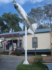 Running Rabbits Military Museum operated by the Upwey Belgrave RSL Sub Branch
Ikara Missile, Maribyrnong Ordinance Factory in Victoria. et al, 1965
During the 1950’s, the growing threat from Submarines, led the Royal Australian Navy to consider a quick reaction, long range ASW torpedo delivery system as an alternative to the USN’s ASROC and the RN’s Match. Full scale research and development began in 1960 using the Turana target drone as the basis for the delivery platform. Shipboard tests began in 1963 and the Government Aircraft Factory (GAF) began production of three variants M3, M4 and M5 in 1965. The M4 variant had a guidance system designed to interface to a full tactical data handling system while the M3 and M5 variants used a simpler system with a dedicated fire control system. The IKARA is an unmanned miniature aircraft with clip on upper and lower stabilizers and wings. The upper stabilizer (SVU) housed and electronic package that transmitted flight data back to the launch platform and received updated target acquisition data during flight. Flight maneuverability was provided by elevons fitted into the trailing edge of each wing, these were operated by an actuator system that received flight correction data transmitted to the autopilot from the fire control system. The payload, either the Mk44 or Mk46 lightweight torpedo was suspended to the underside of the airframe and faired into the body to provide and aerodynamic shape. The forward section of the body housed the autopilot and the thermal battery unit. Propulsion was provided by the MURAWA steel cased, solid propellant rocket motor with a combined boost and sustainer stage. IKARA was capable of engaging a target to the maximum range of the ships sonar, regardless of weather conditions. Target information is fed into the fire control system, which calculated to drop zone for the torpedo taking into account speed and direction of launch platform and target, win speed etc, then tracking the missile to the drop zone where command signals initiate torpedo release. The IKARA is an unmanned miniature aircraft with clip on upper and lower stabilizers and wings. navy, torpedo, rocket, submarine, missile -
 Glen Eira Historical Society
Article - OUTER CIRCLE RAILWAY
This file contains five items: 1/Two copies of a document titled THE OUTER CIRCLE RAILWAY by the Royal Historical Society of Victoria and the Australian Railway Historical Society, Vic div. It details the history of the construction of the Outer Circle Railway and discussed expenses and other factors affecting the construction of the line. Notes compiled by R.K Whitehead, Research and Archives Officer Australian Railway Historical Society Victoria Division. The document includes three maps of the outer circle railway line. 2/Four newspaper articles detailing the history of the Outer Circle Railway Line. They include ten black and white images of various aspects of the railway and three line maps. The first article is titled ‘Rail Link with the Past’. In the COLLINGWOOD COURIER dated 07/10/1970, author unknown. The second article titled ‘Ghost trains of the Outer’ by Kenneth Joachim in the HERALD dated 18/04/1975. The third article is titled ‘Tracks in Time’ by Norman Thompson from NEWS, dated 13/02/1973. The fourth article is titled ‘Our Ghost Railway’ by John Townsley from the HERALD, dated 06/11/1974. 3/A letter from Victorian Railways Chief Estate Officer N.A Wigmore to the Honorary Secretary of the Caulfield Historical Society, dated 19/11/1975 regarding the leasing of land along the Outer Circle Railway Reserve from Dandenong Road to the Hughesdale Station. 4/Two copies of an article titled ‘Outer Circle Railway’ in the CAULFIELD HISTORICAL SOCIETY NEWSLETTER undated detailing the history of the outer circle line. The article includes a map of the section of the line in Caulfield. 5/A Photocopy of two images of train line locations on the Outer Circle Line. One on Warrigal Road, looking south from Ashburton dated 1936. The second is of the Black Bridge over Gardiners Creek dated 1935.outer circle railway, normanby road, caulfield station, outer circle line, rosstown junction railway, monash john, caulfield historical society, poath road, deepdene dasher, ashby dasher, dandenong road, gippsy goods, mallee root mercury, outer circle railway reserve, railway lines, railway stations, steam trains -
Glen Eira Historical Society
Document - History of the City of Caulfield
This file contains 4 items: 1/Typewritten document titled ‘The City of Caulfield’. Author and date unknown. 1 page (back and front), 2 copies. Document covers topics such as origins of the name ‘Caulfield’, early settlement and the Caulfield Cup. 2/Typewritten document titled ‘History of Caulfield Council’. Author and date unknown. 6 pages, 3 copies. Document covers subjects such as early settlement, Aboriginal influence, Caulfield Road Board, Shire of Caulfield, Borough and town boundaries, coat of arms, and Freedom of Entry to the City. 3/Typewritten document (undated + author unknown) titled ‘The Structure of Local Government in Victoria with a history of the City of Caulfield’. 13 pages. Covers the following subjects: Powers, Planning, Public Works, Trading Undertakings, Health Services, Municipalities, Wards Electors or Ratepayers, Voters Roll, Councillors, Officers, Finance, Nature of Soil and Vegetation, Parks and Gardens and Reserves, Coat of Arms, Boundaries, How Did Caulfield get its Name, Aboriginal Influence, Caulfield Road Board, Shire of Caulfield, Borough and Town and the City of Caulfield. Also covered is early settlement. Note at the end of the document mentions that the historical content contained in the last section was based upon a thesis for the Department of Town and Regional Planning, University of Melbourne, 1968 by L. Alwis, P. Rowe, N. Wootten. Melbourne, ‘City of Caulfield: An Illustrated City Report’. 4/Typewritten document (undated) titled ‘The Structure of Local Government in Victoria with notes on the history of the City of Caulfield’. 8 pages, 2 copies. This document also includes a map/diagram of the city with boundaries and wards showing locations of railway stations and parks. Document covers the structure of local government and its functions then goes on to focus on City of Caulfield with subjects similar to those covered in item 3. Document signed off by Deputy Town Clerk.city of caulfield, caulfield john, caulfield baron, caulfield racecourse, elsternwick, ripponlea, st. mary’s church, caulfield council, kooyong road, neerim road, bambra road, greenmeadows house, caulfield park, paddy’s swamp, dandenong road, caulfield grammar school, chisholm institute of technology, murrumbeena, glen eira road, alma road, orrong road, balaclava road, inkerman road, ‘grosmont’, caulfield school room, caulfield road board, caulfield road district, crimean war, victorian amateur turf club, caulfield cup, glenhuntly road, north road, glenhuntly station, ormond station, outer circle railway, local government, gardenvale, carnegie, rosstown, poath road, nepean highway, hotham street, ormond park, princes park, ross william murray, caulfield institute of technology, ‘ross’ folly’, hawthorn road, glenhuntly, ormond, morris t. w., lloyd charles du plan, meals on wheels, shire of caulfield, caulfield railway station, caulfield rsl, bouran road, murrum murrumbeen, kooyong road, great dandenong road, neerim road, trams, prahran and malvern tramways trust, fisher andrew, mackinnon reserve, dover street, ‘glen eira’, blair max cr., insignia, third ordnance services unit, schools, street lighting, lampriere, mr. bevan, the caulfield leader, davies j. henry, curraweena road, st. georges road, o’neill college, hope george, market gardens, koornang reserve, packer reserve, murrumbeena reserve, hopetoun gardens, greenmeadows gardens, mirambeena, caulfield technical college, hart john, langdon h. j., ‘rosecraddock’, judge webb, ‘crotonhurst’, service james, ‘kilwinning’, ricketson henry, grimwade frederick sheppard, airdrie, jenner, st. aubin’s, caulfield john p. t., harlston, lempriere, lord reserve, ‘cantala’ -
 Melbourne Legacy
Letter, Aaron Beattie, 1928
Correspondence between Aaron Beattie Esq from Beattie Physical Culture College Melbourne and E. Hilmer Smith Esq about Girls’ Physical Culture Classes in July 1928. It was intended to aid the Sydney Legacy Club establish classes for girls. Excerpts include the following information: "I would suggest that you form a special C/tee to handle the Physical Culture work. . . . I would suggest that special care be taken to see that none but fully-qualified and trained teachers handle the children - this is all important. . . . We charge every child 5/- per year, payable quarterly. We have been most fortunate here with the girls section. An old friend of mine - Mrs Gillies - is our Hon. Directress. She was - until her marriage - in charge of all Physical Culture training in the State Schools of Victoria, and is a wonderful woman. She takes complete charge, appoints her own staff and so on. We pay some of her assistants from £2.2.0 to £5.5.0 per term of 12 weeks. The class was formed in May last year with 42 girls - we now have 121, and they have left the boys far behind. Enclosed you will find a copy of our measurement chart, which is an important part - every child should be recorded before starting, and again at the end of the year. I am also sending you a copy of our Demonstration Programme. This show was given after the girls had been going for 10 months, and it was a wonderful success - all these things help to bring success, and children seem to want these things to keep them going. . . . We spend about £600 per year on our Children's Work and nearly all of that goes to the Physical Culture side." The correspondence is a good snapshot of the undertaking of Melbourne Legacy running girls' club at that point in time and that Melbourne Legacy was trying to help Sydney Legacy establish a similar program. Legacy was only 5 years old at that time and already the importance of the physical culture classes for girls was underway.Set of three typed and dated handwritten letters on paper between Aaron Beattie Esq, and E Hilmer Smith Esq. 00126.1 on Legacy Club letterhead. 00126.4 on Commonwealth Bank notepaper.girls' club, junior legatee, girls' classes, aaron beattie -
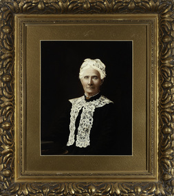
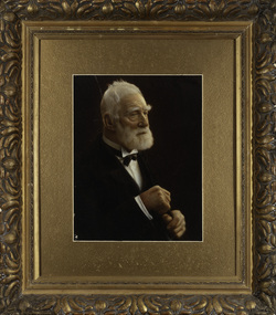 Kew Historical Society Inc
Photograph, James Venn Morgan, c.1905
James Venn Morgan was known affectionately as ‘The Father of Kew’. Born in Somersetshire on February 21, 1823, he sailed to Australia in April, 1851. James V. Morgan, was a member of one of the first parties to leave for the diggings. At Chewton, near Castlemaine his party tried their luck in an abandoned shaft, and in two weeks returned to Melbourne after having won 35lb weight of gold. James Venn Morgan was content with his success, and induced his partners to invest their money with him in land. After obtaining the advice of a friend, the party negotiated with Mr Samuel Watts, of Collingwood, who had recently purchased land from the Crown, and from him they took over at £15 an acre about 32 acres of land in the district that is now known as Kew. This land extended from where the Kew Post-office now stands to the locality of the Boroondara Cemetery. Here it was that Mr Morgan decided to settle, and, after having had the land surveyed, the partners apportioned it by drawing straws for the four sections into which it had been divided. One of them sold his holding later in the year for £100 an acre, and was sorry for it afterwards. In 1853 Mr. Morgan built the first house in Kew, and this house is the one in which he still resides. Here with his wife, he settled down to market gardening and dairying. So successful was the new venture that he induced his father and other members of the family to come out to Australia to assist him. Gradually the district became settled, Mr. Morgan parted with a portion of his holding, and subdivided and built on the remainder, which he still retained. In 1884 he found himself in a position to retire from active business.He celebrated his 100th birthday in 1923. He was later to die in the same year. The Argus, 17 January 1923.Rare and historic hand-tinted framed portrait of one of the founding pioneers of the district.Hand tinted photograph in a gilt frame of the Kew pioneer James Venn Morgan (1823-1923).james venn morgan, kew - pioneer families, kew - landowners -
 Kew Historical Society Inc
Photograph, Anna Morgan, c. 1905
James Venn Morgan was known affectionately as ‘The Father of Kew’. Born in Somersetshire on February 21, 1823, he sailed to Australia in April, 1851. James V. Morgan, was a member of one of the first parties to leave for the diggings. At Chewton, near Castlemaine his party tried their luck in an abandoned shaft, and in two weeks returned to Melbourne after having won 35lb weight of gold. James Venn Morgan was content with his success, and induced his partners to invest their money with him in land. After obtaining the advice of a friend, the party negotiated with Mr Samuel Watts, of Collingwood, who had recently purchased land from the Crown, and from him they took over at £15 an acre about 32 acres of land in the district that is now known as Kew. This land extended from where the Kew Post-office now stands to the locality of the Boroondara Cemetery. Here it was that Mr Morgan decided to settle, and, after having had the land surveyed, the partners apportioned it by drawing straws for the four sections into which it had been divided. One of them sold his holding later in the year for £100 an acre, and was sorry for it afterwards. In 1853 Mr. Morgan built the first house in Kew, and this house is the one in which he still resides. Here with his wife, he settled down to market gardening and dairying. So successful was the new venture that he induced his father and other members of the family to come out to Australia to assist him. Gradually the district became settled, Mr. Morgan parted with a portion of his holding, and subdivided and built on the remainder, which he still retained. In 1884 he found himself in a position to retire from active business. He celebrated his 100th birthday in 1923. He was later to die in the same year. The Argus, 17 January 1923.Rare and-tinted framed photograph af Annie Morgan, the wife of one of the founding pioneers of the district.Hand tinted photograph in a gilt frame of Anna Morgan (nee Chidgey), the wife of James Venn Morgan. Anna Morgan was the wife of one of Kew's earliest pioneers and landowners. She died in 1915.anna morgan, kew - pioneers -
 Surrey Hills Historical Society Collection
Photograph, Grovedale Road Quarry in the 1920s - looking south, c1920
The quarry was part of John Butler Maling's property. He was one of the original settlers of the area and farmed the area between Weybridge Street and Whitehorse Road. Clay was quarried from part of this area and used to make the bricks used in the construction of his home, known as 'Ancyra'. This is still extant at the corner of Weybridge and James Streets. Maling grazed cows and used the quarry as a water source. He was the uncle of John Butler Maling, Mayor of Camberwell. He was married to Kate Conlon in 1882. They had 3 children: Silas Young, Alick and Zillah. Maling was born in c1829 in Shepreth, Cambridgeshire; he died in Surrey Hills on 9 October 1912 and is buried in Box Hill Cemetery - CE-*-0586. Mrs Kate Maling (born c1859 in Co Meath, Ireland) died at the property on 8 March 1921. She is buried in Brighton General Cemetery. Probate was valued at over 10,000 pounds and included other properties in Sandringham, Hawthorn and Macedon. At the time of her death the Surrey Hills property was described as being 23 acres with 2 brick houses, 1 cow, 2 heifers and 40 fowls or chickens. The property was subdivided after her death. The property was subdivided into 110 house blocks in c1923 - see Maling's Estate subdivision flyer on the State Library of Victoria's website. This shows that the Grovedale Park site had been acquired by Camberwell Council by this time. An attached newspaper clipping documents prices realised for a cross-section of blocks. The MMBW map of 1925, also on the SLV website, shows the outline of the clayhole / quarry. The quarry was filled in after several drownings or near drownings and the land is now occupied by a park and playground, known as Grovedale Road Park, maintained by the City of Boroondara. Beckett Park is sited on horizon to the left beyond the trees. This documents the landscape prior to close settlement and is material to early building and farming in the Surrey Hills area.Black and white photo of the quarry between Grovedale Road and James Street taken in the 1920s and looking south. In the foreground is an area of water with reeds in the LH corner. Beyond on the high banks there are single storey houses in the background and (?) some light poles. An object that looks like a tank on posts is in a cutting on the far bank.quarries, grovedale road, james street, clay quarries, farming, kate conlon, kate maling, john butler maling, ancyra -
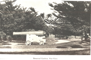 Port Fairy Historical Society Museum and Archives
Photograph, Botanical Gardens Port Fairy
One of the large cannons located in Port Fairy in reply to the threat from foreign invaders. Originally located in the fort on Battery Hill they migrated to various destinations around the town. One of the two originally located at King George Square found its way to the gardens where it occupied several locations before resting at the car entrance to the Gardens - possibly when the Avenue of Honour was planted in Bourne Avenue. A great favorite with the kids of the town, both have now been returned to their original location where they are currently having their carriages refurbished. The Port Fairy Botanical Gardens were formed in 1856 making it one of the earliest gardens in Victoria. The first curator was James Prior, he was paid fifty-two pounds per annum. He was an outstanding curator having been apprenticed to the trade in England at the age of 12, his brother Edward in later years was the Curator of the Koroit Gardens. Prior retired in 1903. During the years of his curatorship Port Fairy was said to have the best gardens outside the city of Melbourne, he was constantly in touch with Baron Von Mueller and later Guilfoyle of the Royal Botanical Gardens of Melbourne. In the early years plants from all over the world were planted here with varying rates of success many of them sent by Baron Von Mueller. In the 1930’ and 40’s the gardens were still very beautiful, and the curator was Roy Manuell. The beautiful iron gates at the entrance were destroyed in the 1946 floods and were replaced in 1989 using some of the material from the original gates. From the 1950’s on the gardens went into a state of decline, much being taken up by the caravan park until in 1986, after a public meeting ‘Friends of the Gardens’ was founded when the entrance section was restored. Black & white photograph of the Large cannon situated in the Botanical GardensBotanical Gardens Port Fairybotanical, garden, cannon -
 Melton City Libraries
Photograph, Melton Railway Bridge, c.1884
"The Melton Viaduct, opened in 1886, is of State heritage significance as a very large and visually distinctive wrought iron, lattice girder trestle bridge over the Werribee River (now Melton Reservoir). It comprises 18.3 and 9.1 metre spans, in a generally alternate arrangement, of total length 375 metres, and standing 38 metres over the Werribee River. Wrought iron small section iron was used to build tension trussed trestle legs, which supported four lines of rivetted wrought-iron deck-type double lattice trusses. It has bluestone abutments and pier bases of coursed rock-faced bluestone with drafted margins. The larger half-piers, now usually submerged in the Melton Reservoir have sharp tapered cutwaters and curved coping at the tops. While designed to carry two rail tracks it has only ever been used as a single track line. Despite several alterations to its deck structure, it remains an outstanding example of a lighter structural design employing open metal trestle supports and metal truss girders. The direct Melbourne to Ballarat railway link of which the Melton viaduct was the major engineering work contributed significantly to the history and development of Victoria. This new link reflected Ballarat’s diversifying economy as well as the commercial and political influence of the metropolis. Construction of the bridge, and the associated large workers camp, were extensively photographed, documenting an important episode in local history. The railway enabled the development of new industries in the Melton area, notably the timber industry and a chaff industry of national importance, greatly facilitated the later transition of the Shire from a pastoral to a farming economy, and struck a major blow to Melton township’s era as a wayside town servicing Ballarat road (especially coach) traffic". Melton Railway Bridge being built across the Werribee Rivertransport -
 Melton City Libraries
Photograph, Denominational Church and School, Unknown
Presbyterian Church Melton Background: A Combined Denominational Church and School was established in Melton by Protestants from the Presbyterian, Episcopalian, Wesleyan and Baptists denominations. A wooden church was built on the flat area east of the Toolam Toolern Creek. A photo of this church shows the buildings with small houses nearby. In the background the bluestone Presbyterian Church built in 1867 can be seen to the north on Yuille and Sherwin street. The flat area beside the road to Ballarat was subject to flooding and the site was eventually abandoned for a settlement. By the latter part of the 1860s the Church of England and Wesleyan bluestone churches were also being erected in the centre of the township of Melton. The commercial centre developed in High Street from Smith to Palmerston Street. Township of Melton Crown Grants Issued Under Common Law refers to the site of the Combined Denominational Church and School on the east side of Sherwin Street on the corner of Pyke Street. Section 4 Allotments 1 and 10 situated on the corner of Pyke, Bryan and Sherwin Street. The early map has the name of Thomas Cridge on this site. The area known Common (flat) remained open level ground with some cottages and buildings and a milk cooler in the 1930s, Granny Watts house “Lynch Cottage was moved in 1964. Sherwin Street was used until the 1960s with the open area being the used for playing golf. Alterations to the flat occurred when the golf course added to the height and removed the Sherwin Street access. The greens were developed and the height of ground altered the vista across Common. The first Presbyterian Minister in the district was the Reverend Alexander McNicol an advanced student and an experienced missionary from Glasgow, arriving in Melbourne in 1850. He was ordained on the 8th of June and was called to the Bacchus Marsh and Mount Macedon district. On the 1st of May 1851 he was called to Geelong and returned to Bacchus Marsh on February 1856 remaining until July 1859. Group of people in front of the church and school.churches, local identities, education -
 Wodonga & District Historical Society Inc
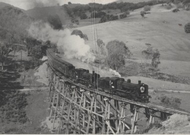
Photograph - Fred Rochow Railways Collection - Cudgewa as it was, 27 January 1989
The Fred Rochow Railways Collection incorporates photos related to the operation of the Wodonga Railway Station including different types of trains and railways staff C. 1930 – 1990. It was donated to the Wodonga Historical Society by Fred Rochow, a railwayman who spent many years based in Wodonga. He joined the Victorian Railways on 17th June l947 and retired in 1988. For some time, he was a member of the Australian Federated Union of Locomotive Enginemen and served a term as a member of the Trades Hall Council. He had an extensive knowledge of the struggles that took place to achieve better conditions for railway workers. Fred worked for many years as a fireman and then worked his way up the ranks to driver, experiencing many changes from the days of steam locomotives through to diesel trains, locomotives and even the modern XPT train. He worked throughout Victoria at different stages of his career, with his final working years focused on the northeast of Victoria and the Albury to Melbourne line. After his retirement, Fred continued to share his love of steam miniature trains with the community. Cudgewa Line -The Cudgewa railway line opened in stages between 1889 and 1921. The first section from Wodonga to Huon opened on 10 September 1889. It was extended to Bolga on 18 July 1890, Tallangatta on 24 July 1891, Shelley on 13 June 1916 (the highest station in Victoria), Beetomba on 10 April 1919 and Cudgewa on 5 May 1921. In 1919, the line was used to carry materials for the construction of Hume Weir, and three years later a spur line connecting Ebden to the weir was opened. In the 1960s, Cudgewa became the railhead of materials for the Snowy Mountains Scheme. The last passenger service from Wodonga to Tallangatta ran on 30 September 1961 The turntable and passenger platform at Cudgewa were abolished in 1976.This collection has local and statewide significance as it captures images of trains, locomotives and personnel who operated the railway services in Wodonga and throughout Northeast Victoria. The railways played a critical role in opening up Victoria and connecting Australia for trade, business, social communication and transport.What remains of the Cudgewa Railway Station taken in January 1989. A disused shed in a paddock is all that remains of a once busy station.railways wodonga, fred rochow, cudgewa station, high country railway line -
 Wodonga & District Historical Society Inc
Photograph - Fred Rochow Railways Collection - Historical Special to Cudgewa, 3 November 1963
The Fred Rochow Railways Collection incorporates photos related to the operation of the Wodonga Railway Station including different types of trains and railways staff C. 1930 – 1990. It was donated to the Wodonga Historical Society by Fred Rochow, a railwayman who spent many years based in Wodonga. He joined the Victorian Railways on 17th June l947 and retired in 1988. For some time, he was a member of the Australian Federated Union of Locomotive Enginemen and served a term as a member of the Trades Hall Council. He had an extensive knowledge of the struggles that took place to achieve better conditions for railway workers. Fred worked for many years as a fireman and then worked his way up the ranks to driver, experiencing many changes from the days of steam locomotives through to diesel trains, locomotives and even the modern XPT train. He worked throughout Victoria at different stages of his career, with his final working years focused on the northeast of Victoria and the Albury to Melbourne line. After his retirement, Fred continued to share his love of steam miniature trains with the community. Cudgewa Line -The Cudgewa railway line opened in stages between 1889 and 1921. The first section from Wodonga to Huon opened on 10 September 1889. It was extended to Bolga on 18 July 1890, Tallangatta on 24 July 1891, Shelley on 13 June 1916 (the highest station in Victoria), Beetomba on 10 April 1919 and Cudgewa on 5 May 1921. In 1919, the line was used to carry materials for the construction of Hume Weir, and three years later a spur line connecting Ebden to the weir was opened. In the 1960s, Cudgewa became the railhead of materials for the Snowy Mountains Scheme. The last passenger service from Wodonga to Tallangatta ran on 30 September 1961 The turntable and passenger platform at Cudgewa were abolished in 1976.This collection has local and statewide significance as it captures images of trains, locomotives and personnel who operated the railway services in Wodonga and throughout Northeast Victoria. The railways played a critical role in opening up Victoria and connecting Australia for trade, business, social communication and transport.Historical Steam locomotive on journey to Cudgewa. Locomotive K184 leading with Driver Noel Strauss and Fireman Barrows. Locomotive K186 is the Banker with Driver Doug West. A banker is railway locomotive that temporarily assists a train that requires additional power or traction to climb a gradient. K Class Locomotives - One of VR's most successful classes of loco they were built over a 24 year period. A general purpose, light lines loco the K class had a very long career in all sorts of service from branch line passenger and goods work to pilot and banker duties and roadside mainline service. The K class is credited with working virtually every line in the VR system and hauling almost every kind of train. The majority of the class lasted into the 60's. K 184 and K186 were built by the Victorian Railways' Newport Workshops in 1945 to the successful K-class 2-8-0 locomotive design for branch-line work. K184 entered service on 9 January 1946. K186 entered service on 19 March 1946. K184 was used on heritage services with Steamrail Victoria through the 1970s. It was withdrawn from service in 1980 and is stored at Newport Workshops. and is now used as a source of spare parts; other Steamrail K Class locomotives occasionally wear its number plates and headlight number boards. K186 was scrapped on 25 October 1967.railways wodonga, fred rochow, cudgewa station, high country railway line, k class locomotives -
 Wodonga & District Historical Society Inc
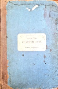
Document - House Creek School 2266 Inspector's Register Book 1881 - 1905
This folder contains the official Inspector's reports for House Creek School Number 2266. Inspections were carried out every six months for all Victorian Government Schools. On 8th October 1879 Mathew Parnaby and others applied for the establishment of a school, between Huon and House Creeks, about four miles southwest of Wodonga. The District Inspector approved and Albert Schlink offered two acres of freehold land as a site, four chains from the southeast corner of Allotment Eight, Section 10, of the Parish of Wodonga in the County of Bogong. A portable classroom, 22ft x14ft, with quarters was erected at a total cost of £192, and SS2266 opened on 1st of June 1880 with Edwin Davis as Head Teacher. In 1883 the average attendance ranged between 12 and 20. Both school and quarters fell into a very bad state of repair. Temporarily closed in 1894, the school reopened as a result of a petition by Ferdinand Godde and others. By 1902 the school had a nett enrolment of 37, the grounds had been fenced, and a shelter shed erected by local effort. By 1907 the nett enrolment had risen to 45 with an average attendance of 37. Ferdinand V. Godde served as Correspondent of the Committee in 1911. House Creek was unstaffed in February 1917 and closed on 8th of November 1917. It reopened on 4th August 1921, but with a nett enrolment of 6, closed on the 24th July 1926. The building was sold for removal. Many of the reports in this Register were written and signed by Henry Finch Rix. He was a pioneer of the Victorian School Inspection System and from 1884 to 1887 worked as a Chief Inspector in the Beechworth Education District. He had previously played with the Carlton Football Club for one season. Henry Rix was a highly regarded educator and a staunch advocate of the establishment of school libraries to teach children of "the rich stores of profitable pleasure to be found in books."This item is significant because it documents progress and recommendations for students at an early government primary school in the Wodonga district.A large bound folder of printed forms. The majority have been completed in handwritten reports including names, notes and statistics. On cover: INSPECTOR'S REGISTER BOOK STATE SCHOOLShenry finch rix, house creek school, victorian school inspectors, school 2266 -
 Eltham District Historical Society Inc
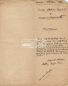
Document, Conveyance, Lot 20 Henry Street, Eltham, Hope of Eltham Tent No. 195 I.O.R. to W.J. Capewell and others, 31 Dec 1926
Indenture between Jack Alfred Harrison, Accountant, Edward Samuel McColl, Council Employee, both of Eltham and William Wilson, Coachbuilder of Research, the Trustees of a certain Friendly Society known as The Hope of Eltham Tent No. 195 Victorian District I.O.R of the one part and William James Capewell, Butcher, Ernest James Andrew, News Agent and George Birchall, Hatter all of Eltham of the other part, Trustees for The Eltham Hall, for the purchase of Lot 20 Henry Street for £750. Witnessed by Hubert James Carter J.P for Jack Alfred Harrison, A.H.C. Price J.P. for Edward Samuel McColl and J. Webster J.P. for William Wilson. Originally purchased in 1856 from Thomas Roberts, Yeoman of Little Eltham, for £10 for use by the Wesleyan Chapel, represented by indentured Trustees, Rev. Barnabas Shaw Walker, Minister of the Pentridge Circuit, Francis Thomas, Farmer of Keelbundora, William Harriman, Blacksmith of Nillumbik, Nicholas Rodda, Farmer of Nillumbik, Aaron Grimshaw, Farmer of Greensborough, Joseph Cooper, Gardener of Keelbundora, Peter Dredge, Scholmaster of Jika Jika and Samuel Jeffrey, Farmer of Jika Jika. Lot 20 of Subdivision of Portion 13, Section 4 of the Parish of Nillumbik in the County of Evelyn was located on the southern side of Henry street in Little Eltham North, where the current Our Lady Help of Christians Catholic Church is situated. It became the location of the Eltham Rechabite Hall. In 1893 a new hall was built and further enlarged in 1919. At the commencement of 1922, the property was purchased from the Independent Order of Rechabites with publicly subscribed funds and a new hall built at a cost of £750 and improved road access constructed to reduce the grade, running from Dudley Street to Henry Street. This hall was eventually replaced with the new Shire Offices and Hall built on the corner of Arthur Street and Main Road, which was opened in 1941. Traces the earliest history of the Eltham Public Hall in Henry Street and the various names, occupations and abodes of the Trustees associated with the property -
 Flagstaff Hill Maritime Museum and Village
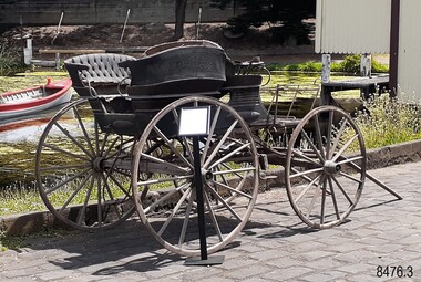
Vehicle - Murweh Carriage, c.1874
This private late-nineteenth-century four-wheeled carriage has been built to transport a family or group of passengers with a coachman in the front seat. It can be pulled by one horse, or by two horses if the T-pole is attached. The button fittings along each side of the carriage indicate that a folding roof or hood was once attached. The frame across the front of the carriagewas likely to have been a ‘dashboard’ with a leather or wood covering to prevent water, mud and other particles from splashing onto the passengers. The rear step between the two side-facing bench seats is adjustable to allow for ladies’ long skirts. These rear seats appear to be removable, in which case the carriage could be converted to a wagon to transport goods and equipment. The carriage could have been illuminated by oil or carbide lamps placed into the lamp holders on the sides. The carriage was kept under cover for many years in an open-front sandstone building that also included living quarters and an area that may have been stable. It was at ‘Murweh’ a Warrnambool property at 203 Liebig Street. The home is now Heritage and National Trust Listed and described as a ‘gentleman’s residence’. It was built by James Wotton Shevill in the 1860s. Shevill was a councillor from 1875 to 1878, serving in 1878 as Mayor of the Borough of Warrnambool. Jeremiah Wade lived at Murweh there from 1879-1880. By 1915 F.B. Whitehead and his family were living there, and by 1930 the address was used by Mr T.J. Rome and his family. Thomas James Rome was still using that address in September 1973 after his 100th birthday. It is believed that one of the property’s owners had been an Obstetrician in Warrnambool. The current owner re-told the story that children used to hide in the back section of the carriage and smoke, hidden from the sight of onlookers. He had heard the story from a previous owner.The well-appointed horse-drawn four-wheeled carriage is likely to have first belonged to a local councillor and past Mayor of the town of Warrnambool, J.W. Shervill, whose 1860s city property was the carriage location for many years. The carriage is a rare local example of a town-based lifestyle befitting a prosperous personality of the late 19th century. It adds to the story of Warrnambool's development as a town influenced by the port, wealth gained from shipping and the home place of prominent local people such as the Councillor and later Mayor. The side-facing rear seating is unusual for a passenger carriage. It has the feature of removable rear bench seats, allowing for the dual purpose of a carriage or wagon.Carriage; the Victorian-era horse-drawn four-wheeled open carriage has a coachman’s bench seat across the front and two side-facing bench seats in the rear. There are steps at the front on each side and a centre adjustable step and the back. It has a hinged shaft, two lamp holders and a separate T-pole. The bench seats have padded backrests upholstered in green leather and each has padded armrests at the ends. A rectangular metal frame, likely to have been a dashboard, is mounted across the front of the carriage. It has two inner vertical bars. The carriage's body is painted dark green with crimson highlights on some of the panelling. Decorative oval panels with hand-painted motifs are mounted along the sides. The side panels of the carriage have metal fastener buttons attached. The iron-rimmed wheels have sixteen wooden spokes and copper cuffs on the outside of the hubs, and the rear wheels are higher than the front wheels. Wooden brake blocks are mounted onto the back wheels and are active by a metal lever at the front right side of the carriage. The undercarriage is fitted with leaf springs on each side, mounted from front to back axles. Included are: (1) The separate T-pole that allows two horses to be harnessed to the carriage (2) Leather horse winkers with metal hardware and oval brass plate on the side of each winkerMotif painted on an oval panel [a musical lyre within a blue floral wreath flanked by scrolls] flagstaff hill maritime museum and village, warrnambool, great ocean road, shipwreck coast, murweh, buggy, cart, carriage, wagon, horse-drawn vehicle, victorian buggy, four-wheeled carriage, coachman’s seat, bench seat, side-facing benches, upholstered seats, victorian decals, heritage vehicle decoration, antique hand painting, hand painted decals, motifs, iron-rimmed wheels, wooden brake blocks, leaf springs, t-pole shaft, rear step, equine carriage, 19th century vehicle, victorian transport, transport, gentleman’s vehicle, james wotton shevill, councillor, mayor, jeremiah wade, f.b. whitehead, thomas james rome, warrnambool obstruction, warrnambool genealogy, warrnambool pioneers, victorian carriage, one horse carriage, two horse carriage, horse drawn carriage -
 Kiewa Valley Historical Society
Photograph - Folder of Photographs – Photocopied set of black and white photographs (pages 39 - 48) from the display folder put together by KVHS to document life on the Kiewa Valley Hydro-electric Scheme
Although the Kiewa Hydro-Electric Scheme was first proposed in 1911, construction did not commence until 1938. As part of the push to cut electricity costs and diversify supply, the Victorian Government (circa 1930) initiated the conversion from primarily brown coal supply to hydro – electricity. Field investigations during the 1940’s resulted in a new proposal for a scheme that had more than double the capacity of the 1938 scheme. The Kiewa Hydroelectric Scheme became the largest scheme of its kind in the State Of Victoria and the second largest scheme in Australia. The number of personnel involved in the planning and construction of the scheme increased dramatically. During the late 1940’s, most activity centered around the construction of the West Kiewa Power Station, Rocky Valley Reservoir, McKay Creek Power Station and the Bogong Creek Aqueduct.A common thread across all the larger hydro scheme constructions was the need for workers, both qualified and unqualified who came from around the world seeking a new life for themselves and their families. New accommodation and facilities were required for the army of workers engaged in construction in often remote and wild areas. The SEC had a high demand for timber, and set up the first of a number of sawmills at Bogong Creek in 1939 and set up the first hardwood logging in the headwaters of the Kiewa River. These new ‘towns’ such as Mt Beauty and Bogong, survived, serving the needs of operational personnel and their families, and expanding with growth of new industries. Mount Beauty, and to a lesser extent Bogong, are among these places. Large A3 size spiral bound display folder containing photocopied black and white photographs of various aspects of the early days of the Kiewa Valley Hydro-electric scheme including equipment, various work sites and photographs of workers and their families. 1-Breakdown in Circuit Breaker (Isolating Contacts) 2-Big Hill Bench- Site of No 5 Devlopment 3-No 1 Power Station 4-No 1 Pipeline, Anchor No 8 5-Push Dozing-RD8 Tractor 6- Tractor and driver at work 7- Workmen in unnamed tunnel 8- Front page of Journal of SECV Vol 15. Photograph of No 1 pipeline viewed from McKay Portal 9-Rocky Valley Dam Core Wall 10-Workmen working inside tunnel loading rocks into a rail truck. 1-Breakdown in (generator) Circuit Breaker (Isolating Contacts) Handwritten underneath (This is not a picture of any part of a generator. It is a circuit breaker Signed Ron White Ron was the Principal Hydro Engineer of the SEC Kiewa Scheme Page number 39 2-Big Hill Bench – Site of No. 5 Development (abandoned) Page number 40 3-No 1 Power Station Page number 41 4-No. 1 Pipeline, Anchor No. 8 Page number 42 5-Push Dozing – RD8 Tractor, 12 cubic yard Carryall and FD Cletrac Tractor Page number 43 6-No marking Page number 44 7-No marking Page number 45 8-Journal of State Electricity Commission of Victoria SEC Vol 15 No… April-May, 19… No 1 Pipeline-A view from McKay Portal G Hempenstall and D Sutton stiffening pipe section for transport during construction (….indicates missing text) Page Number 46 9-Rocky Valley Dam Core Wall Page number 47 10-No markings Page number 48 secv; kiewa hydro electric scheme; construction area; power stations; reservoirs; aqueduct; mt beauty; bogong -
 Bendigo Military Museum
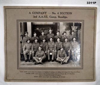
Photograph - PHOTOGRAPH WW2, BENDIGO, c.1940
Black & white photo of a group of 16 Australian Soldiers, taken in Bendigo. Black print identifies company & troops. Mounted on heavy fawn coloured cardboard.In black print above photo: “A COMPANY - NO 4 SECTION 3rd AASC, CAMP, BENDIGO” In black print below photo:BACK ROW L-R: R J Smith, L C Polgaise, H Jobling, L G Gilliam, H C Jones, H H Major, R B Ennis CENTRE ROW L-R: S H Mounsey, H Hore, Cpl F G O'Leary, Sgt O R Hamilton, Cpl P J O'Leary, J Kirby, F L Jeffery FRONT ROW L-R: D J McPherson, W R Larke” On back: Bill LARKE Murphy St Bendigo joined the Army Training Camp at Racecourse Bendigo in June 1940. Started as 3rd Australian Army Supply Service Corp. Changed to 2/32 Training Battalion (a camp was opened at Showgrounds Bendigo but closed down later). 2/32 T Battalion became 2/22 Training Battalion, they marched out of Racecourse Bendigo to Puckapunyal and became 4th Anti Tank Regiment.photography, aasc, bendigo -
 Mt Dandenong & District Historical Society Inc.
Photograph, Jeeves Coach on CRB Road at Foot of Farringdon Road Kalorama, 1920, 1920
Scene looking down Farringdon Road showing Jeeves horse drawn coach going along the CRB road (Mt Dandenong Tourist Road) in 1920. Detailed inscription on the back handwritten by John Lundy-Clarke in 1974.Jeeves Coach on CRB road at foot of Farringdon Road Kalorama (Mt Dandenong North) 1920. Road was formed most of the length from Montrose by contractors Bladin and Dick employing Robert Logan the younger, in 1919 and lay unmetalled till metalled by the contractors in 1922. Mountain ash trees in foreground were on Thomas Hand’s original 23 acre holding. Those beyond coach were on Isaac Jeeves original 160 acre holding Selection Crown Allotment 925(B). This was the area forming part of the inheritance lost by John William Richardson because of the expense of his wife’s illness. Hand enlarged his 23 acres to 305 in 1874. William and his family grew large crops of raspberries on his area, part of which is in the foreground. It had been cleared by his father’s employees before 1877. The section below the Main Road was cultivated by Fred hand, son of William and grandson of Thomas in the twenties before he moved to Redcliffes where he is today (1974). Comment by John Lundy-Clarke 10.5.1974 coach service, jeeves, crb road, farringdon road, kalorama, mt dandenong north, mt dandenong tourist road, john lundy-clarke, coach -
 Eltham District Historical Society Inc
Document - Report, Paul Jerome, Advisory Committee on a Proposed Convenience Centre and an Alternative Shire Proposal - Eltham Gateway Community Precinct Concept Plan - 895 Main Road Eltham, October 1997
On 15 December 1994 the former Shire of Eltham ceased to exist following the Liberal Kennett Government local council amalgamations. A new Nillumbik Shire Council was established with unelected commissioners appointed. That Council sold the former Eltham Shire Council Offices and land at 89S Main Road Eltham to Dallas Price Homes Pty. Ltd. the sale being conditional upon the granting of a planning permit for a petrol station/convenience store, fast food and video outlet. The sale was conditional that if the permit was not granted by 30 August. 1997, the contract could be avoided by either the purchaser or the vendor. The proposed development consisted of a petrol station with undercover fuelling facilities, convenience shopping, a drive through service facility for fast food, an 80 seat cafe, automated banking, a children's play area and retail space. In addition, the proposal included a 200 square metre community facility for Council use, provision of on site carparking over 2 levels for 83 vehicles, and advertising signage. An Advisory Committee consisting of Dimitry Reed and Margaret Pitt was appointed under Section 151 of the Planning and Environment Act 1987 to hear submissions on the proposal to develop the land at 895 Main Road Eltham, the site of the former Eltham Shire Offices. In September 1996, two applications were made by Contour Consultants Australia Pty Ltd on behalf of Dallas Price Homes Ply Ltd, to Nillumbik Shire Council. After extensive notification, the Council received 213 objections and a petition of over 1400 signatures. On October 9, 1996, Nillumbik Shire Council issued Notices of Decision to Grant Permit on Applications number 96/03376 and 96/0377 for the use and development of the land as a convenience Centre consisting of a petrol station, convenience store, cafe/takeaway food premises, a retail facility and a community facility, with associated advertising signs. Objectors to the proposals lodged Planning Appeals number 96/40724 and 96/40812 with the Administrative Appeals Tribunal on November 1, 1996. The grounds of appeal can be summarised as: inappropriate development, insufficient carparking, traffic and access issues, unsatisfactory design, inadequate permit conditions, the proposal being out of character with the area. and being contrary to the purpose and orderly development of the Eltham Town Centre, excessive noise, lack of consultation and unsuitable signage. On November 13, 1996, the Minister for Planning and Local Government directed the Registrar of the Administrative Appeals Tribunal. under Section 41 (1) (a) of the Planning Act 1980, to refer the Appeals to the Governor in Council for determination without a hearing or recommendation by the Tribunal. The Minister for Planning and Local Government called in the Appeals as he considered that they raised major issues of policy relating to the facilitation of development in accordance with the objectives set out in Section 4 of the Planning and Environment Act 1987, and that determination of the Appeals could have a substantial effect on the achievement of these planning objectives. The Minister required the Advisory Committee to consider the planning merits of the proposed use and development, and to address the issues raised in the objections. The Advisory Committee was required to produce a report providing: • The Committee's response to the matters detailed; • Relevant supporting information for the Advisory Committee's recommendation; and • A description of the proceedings conducted by the Advisory Committee and a list of those consulted or heard by the Committee. In March 1997, elections were held in the Shire of Nillumbik and the view of the new Council to this proposal differed from the view held by the earlier Council Hence the Submission made to the Committee by the Shire was against the decision by the Shire of Nillumbik to issue the Notices of Decision to Grant a Permit. The Recommendations of the Advisory Committee were: i. The cafe and take away food premises are as of right uses and are therefore allowable, but that shop and petrol station are unacceptable uses. A community facility is a discretionary use and is acceptable. ii. A development of the type and scale proposed is totally inappropriate for this land and that the Applications number 96/03376 and 96/0377 for the use and development of the land as a convenience Centre consisting of a petrol station, convenience store, café/takeaway food premises, a retail facility and a community facility, with associated advertising signs, be refused. iii. The land should be rezoned for public purposes and should remain in the community's ownership for community use. Following this, the Minister for Planning and Local Government, the Hon. Robert Maclellan, appointed Mr. Paul Jerome as an Advisory Committee under section 151 of the Planning and Environment Act 1987 to consider a Convenience Centre and an alternative proposal by Iha Shire of Nillumbik being the Eltham Gateway Community Precinct Concept Plan for the site of the former Shire of Eltham municipal offices at 895 Main Road, Eltham. In summary, the terms of reference for the Advisory Committee required it to: • consider the merits of the Council proposal • examine the merits of both proposals in terms of net community benefit • address the report of the previous Advisory Committee on the Convenience Centre proposal The Advisory Committee inspected the site and considered all the material before It including submissions made by all parties to the previous Advisory Committee and correspondence received by the Department of Infrastructure both before and after that Committee submltted its report. The Advisory Committee also held discussions with the following people: • Cr. Robert Marshall • Cr. Margaret Jennings • Cr. Lex de Man • Mr. Dallas Howgate of Dallas Price Properties, also Dallas Price Homes • Mr. Barry Rochford, CEO, Shire of Nillumbik • Ms. Yvonne Rust, Planning Officer, Shire of Nillumbik • Mr. Gregory Burgess, Architect of the Eltham Library and of Council’s Community Precinct Concept Plan • Mr. Jim Connor representing Mrs Thelma Barkway of the Eltham Senior Citizens Club Having considered all the material before it, the Committee arrived at two basic conclusions. First, the DPP proposal should be rejected because, on its merits, It does not sufficiently satisfy the requirements of the planning scheme which is a statutory document. The planning scheme requires that, before making a decision on the permit applications for the DPP proposal, a range of matters must be considered. It follows that consideration of these matters should Influence the decision. These matters include local policies relating to character and amenity. In particular, these policies seek • to conserve and enhance the bushland/country atmosphere, artistic heritage and strong sense of community of the Eltham Town Centre by ensuring that the design and height of any new development is sympathetic to existing buildings • to achieve a pleasing physical environment within the Eltham Town Centre by encouraging a high standard of architecture and urban design • to encourage Improvement to pedestrian amenity through such facilities as open and shattered rest areas and meeting places, crossing facilities, pedestrian arcades, pedestrian links to car parks and pedestrian weather protection • to reduce conflict between vehicular traffic and pedestrian flows, and • to encourage pedestrian thoroughfares It is submitted, as set out In the main body of this report, that the DPP proposal fails substantially to meet these policies and In so doing does not merit the exercise of discretion In Its favour with the Issuing of a permit. This finding is not offset by the investment and employment attributes of the proposal. They do not override the need to comply with the planning scheme. Second, the Council proposal, on Its own merits, substantially meets all statutory requirements applicable to this site with a possible reservation about car parking and traffic management which need further definition and assessment as the concept is refined. The Council proposal, however, has a serious weakness in that Its financial viability has not been adequately tested. The Committee refers to 'financial' rather than 'commercial' viability in recognition that Council owns the land and may enter into a range of agreements and partnerships to realise its concept some of which may be truly commercial and some of which may involve an element of subsidy arising from Council's involvement as a public body acting on behalf of its community. The Committee concludes that Council should be given the opportunity, within a reasonable timeframe to establish the financial feasibility of its concept and should develop a strategy for the future of Its land asset at 895 Main Road in the event that Its concept for the site cannot be realised. 895 main road, advisory committee, dallas price homes, eltham, eltham shire office, nillumbik shire council, planning application, administrative appeals tribunal -
Bendigo Military Museum
Uniform - UNIFORM, NURSES WW2, 1939 - 1946
The uniform belonged to CAPT GLADYS MOLE VFX17199 AAMC 2nd AIF. Refer 1901.4 for Service History. Items were all numbered 215.01 from a previous institution. See also Reg No 1899 & 1900.2P.WRANC .1) Jacket. Grey, fine wool tailored jacket & skirt. Jacket has full belt fastened with press studs. Front fastened with military buttons, also pocket flaps & 2 buttons on each sleeve. Shoulder epaulettes of dark brown felt with a button 'Australia' badge & 3 captain's pips. Colour patch on each sleeve - brown square on light grey square with central angled blue bar. Service ribbons on right breast. Upper back section & fronts lined with rayon. Hanging tab centre back neck. .2) Shirt. Long sleeved cream cotton shirt with tail, epaulette tabs on shoulders fastened with a button. Front button fastening semi stiff collar. .3) Skirt. Fastens at side with hooks & eyes & 1 button on waist band. .4) Tie. Made of dark brown crepe with silver Rising Sun badge pinned to it. .5) Hat. Grey/green felt velour with band of brown edged both sides with narrow stripes of pale grey & red. Unlined with petersham sweat band & black hat elastic double chin strap. Signs of wear at inner front. .6) & .7) Gloves. Pair, dark brown leather with stitching detail in 3 decorative lines on backs. Previous number 215.01 has been inked inside. .8) & .9) Shoes. Pair, brown leather lace up with stitched soles by Duncan. .2) Self coloured label: V109 MADE IN AUSTRALIA 1942 Inside back neck in ink: G? HOLLOW .5) On label in black: V558 Made in 1943 Australia Size 6-3/4"uniforms, costumes - female uniform, essential services - hospital, nurses -
 Kiewa Valley Historical Society
Book - Ledger Commercial, "Ledger No. 4", Circa 1895
Historically this ledger not only details the legible hand writing of this era but also the day to day commercial activity in this region(first entry in 1895).The neatness and the diligence of those who were required to pen the information was a requirement by all who were in commercial trade. Emphasis on neatness was ingrained in students at a young age. This era was well before general typewriters and computers. Generally all students of commerce required an accuracy in writing and arithmetic. Neatness and order were a selection requirement. This ledger belonged to a general store, which was a forerunner to supermarkets and specialty stores. The shop provided everything from food, postage stamps, nails, tobacco, boots and Epsom salts. The general store provided nearly every product required to exist in a remote rural area of Australia in the 1800's.This item clearly identifies the Kiewa Valley as having a substantial financial hub to accommodate the various commercial enterprises within a rural environment Circa 1880's. Although Kiewa Valley had mining, agriculture, cattle and sheep it was also composed of a mixed society, encompassing all levels of society at that period. It identifies some the commercial activities(newsagency/general store) undertaken by specific families farming in the Kiewa Valley and relates their history in the pioneer period of the late 1800's. Some of those pioneers still have descendants living on the same home sites provided by the 1847 Land Act.This ledger has a very thick cover of strong compressed cardboard. Originally it had a cloth covering both front and back(Glued on) but due to wear and tear it is only attached to the back cover) and is a faded blue colour. The corners of the opening side of the cover are reinforced by suede cloth,in a triangular shape, and enclose both the front and inside portions of the the ledger. The spine is reinforced by a suede section to provide increased strength and protection. The inside cover (both front and back) has an orange bubbles with red and blue sinuous lines forming shapes in a haphazardous pattern. The grammage of the lined sheets (blue) is approximately 120g/m. Originally the first seven of twelve pages were indented and alphabetically marked with black letters (one letter per page) however this ledger had been modified to cover only the initials of customers and the pages of unused letters were glued to the previous page. The remaining pages are numbered in black print at the top outside edge of each page. There are 890 page numbers. Each page has thirty seven blue horizontal lines and one double red line ( top). Each page has thirteen vertical lines starting from the top horizontal double red lines and ending at the bottom of the page. These lines segregate the page into blocks for the date, the transaction and financial input. There are three double vertical red lines which designate the amount of money of each transaction (in pounds, shillings,and pence).On the suede spine in gold lettering and on a red (port coloured) background "LEDGER"grocery shop, haberdashery, general store -
 Warrnambool RSL Sub Branch
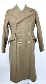
Great Coat, Bradley's Industries N.S.W, 1951
Long khaki coloured heavy coat. Thick, sharp angled collars. Right collar has a hook and eye attached in the lapel split. Collar has zig zag stitching and two plastic buttons on each the left and right sides. Each shoulder has a lapel that is fastened with a plastic button. The coat is double breasted. Three buttons on the right side, held in place by metal loops on the interior rather than stiches; mirrored on the left side. Left interior has oval shaped fabric buttoned to the interior with two brown (possibly bakelite) buttons. A larger brown button sits atop the smaller as a means of closing the jacket from the inside. There are two pockets on the front that are angled with the highest point near the centre and the lowest point near the hips. The arms, underarm and upper back section contains an inside khaki coloured lining of thinner, most likely cotton fabric. Above this there is a thin strip of fabric attached at either short end to use for hanging the coat on a hook. At the back of the coat there is a single pleat stretching from the base of the neck to the base of the coat. Approximately half way down the pleat there is a split in the fabric that is fastened with two plastic buttons. At the waist there are two fabric flaps that fasten together at the back with three buttons, also held in place with metal loops on the reverse.Label on interior back lining reads "REGIMENTAL No./NAME" Label on interior of the right "GREATCOATS. G.S. 1946 Patt/SIZE 1/HEIGHT 5'3"/CHEST 34"-36"/BRADLEY'S INDUSTRIES N.S.W./1951" Handwritten on label, "M J Davis"post war, army uniform, great coat, inter war, uniform, military uniform, wool, greatcoats, bradley's industries -
 Federation University Historical Collection
Book, Machinery for Metalliferous Mines, 1894, 1894
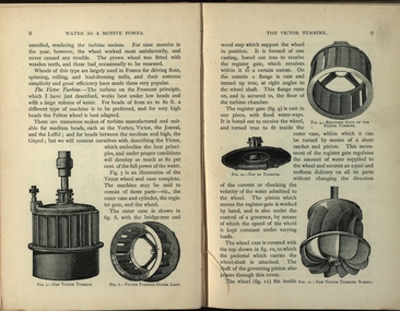
The 1st edition of this famous work, giving an excellent account of the machinery used in late 19th century metal mining in the UK and overseas is very rare. It covers a wide range of equipment - pumps, steam engines, drills, winding engines, stamps & concentration mills, aerial ropeways, tramways and early uses of electricity etc. Brown hard cloth covered book. xvi 564 pages with additional advertisements, with over 300 illustrations and drawings, some fold out. Chapters include Water as a motive power, Wind engines and ventilating machinery, Steam boilers/engines and oil engines, hoisting machinery, draining of Mines, pumping engines, rock drilling machinery, boring machinery, concentration machinery, sizing and classifications trommels, joggers and jigging, fine concentration, milling of gold ores, milling of silver ores, amalgamation plates and machinery, dry and roasting machinery, chlorination and cyandide processes for the extraction of gold, electricity as a motive power for mining, electric lighting and blasting, aerial wire ropeways, transport by rail and road. There a a number of lovely line illustrations in the book including: Poncelot's undershot waterwheel; Fromont furnace;Victor turbine; Pelton waterwheel; Root's positive blower;Cross section and front elevation of Lancashire boiler; Robey's Compound Mill Engine; Portable Winding Plant; Iron Pit Head Gear ; Loading Arrangement in an Incline Shaft; kibble; Worthington Pump; California Pump; Scram's Air Compressor; Rock drill Bits; Special Sharpening tools; Boring tools;Rotating Picking table; Ore Feeder; roller crusher; stamp battery; round buddle; slime table; vanner; amalgamating plant; belt elevator;roasting furnace;splicing wire rope; capel; tipping waggon;mining, cornish pump, linkenbach table, water wheel, ventilation, oil engine, california, america, water, steam boilers, steam engines, oil engines, pumpimg, rock drilling, boring, jiggers, milling, silver, gold, drying and roasting, chlorination, cyaniding, lead, zinc, copper, electricity, electric lighting, wire ropes, transport, wind engine, poppet head -
 City of Moorabbin Historical Society (Operating the Box Cottage Museum)
Photograph - Plateway (Wheelway) Steel, circa 1885
By the later 1800s the dirt roads in the then out-lying areas of the City of Moorabbin became dangerous, and almost impassable due to huge potholes and muddy swampy areas. The heavily laden market gardener’s carts regularly broke axles and wheels, and horses foundered on their way to the Melbourne markets. Even worse, the heavier “iron maidens”, carrying their malodorous loads of sewage from Melbourne’s inner suburbs for dumping in the outlying areas of the City of Moorabbin, also got bogged in the mire. It was decided that a practical solution to this problem was to install a metal plateway on the side of the problematic roads. In about 1887 the Moorabbin Shire Centre Road, in the Brighton East area, two parallel metal rails were installed so that the wheels of carts could run along smoothly, the horse travelled in the filled, middle area between the rails. Point Nepean Road plateway was removed in 1930 and Centre Dandenong Road plateway was removed in 1934-35. The worn plateway along Centre Road, East Brighton (now known as Bentleigh), was gradually taken up in several pieces, commencing in the the1920s, when its condition deteriorated and it caused a hazard to bikes, pedestrians, motor-cycles and the few early cars. The early steel plateway, constructed by David Munro, and opened on 23rd March 1885 by Thomas Bent, was built along Nepean Highway, between Asling St. and Bay St. The Point Nepean Track was subsequently extended into Moorabbin with branches along Centre, Cumins, South, Wickham, and Keys Roads, the total length was 13 miles. In 1908-1909 plates were laid along Centre Dandenong Road to Ross Street Bentleigh This innovative solution proved successful and was used until gradually the main roads were upgraded, and motorised vehicles started to appear. Two parallel metal rails were installed in the right hand side of a few main roads in the Shire of Moorabbin so that the wheels of heavily-loaded market gardener's carts on their way to markets in Melbourne could run along smoothly. The horse pulling the carts travelled in the filled, middle area between the rails. The Steel Plateway was constructed by David Munro, and opened on 23rd March 1885 by Thomas Bent. The wheelway first only ran along Nepean Highway, but it soon extended from Centre Dandenong Road, along Nepean road to its junction with Chapel Street, St Kilda. Later branch lines were built along Centre Road, Bentleigh as far as Warrigal Road and, according to early photographs, along Wickham Road Moorabbin as well. This innovative solution proved successful and was used until gradually the main roads were upgraded, and motorised vehicles started to appear. There was a problem with the wheelway : there was only a single set of rails and this was established on the right-hand side of the Nepean Road, travelling towards the city. Traffic FROM the city travelled on the correct or left-hand side of the road. The exception to this rule was the malodorous iron-clads, heavily riveted iron carts, generally travelling in convoy, carrying several tons of human effluent out of Melbourne to be trenched-in in the sandy soil of the Moorabbin district. Moorabbin City Council donated and installed a small section of Plateway at Box Cottage Museum in 1984melbourne, brighton, moorabbin, roads, plateway, wheelway, transport, st kilda, bent thomas, munro david, market gardens, steelway, carts horse-drawn, iron maidens, point nepean track -
 Bendigo Historical Society Inc.
Clothing - AILEEN AND JOHN ELLISON COLLECTION: TROUSSEAU NIGHT GOWN, 1914
Handmade ivory coloured cotton full length night gown. Front has yoke of diagonal pieces of lace with cut work and floral patterns, squares, embroidered flowers with horizontal lace pieces across shoulders. The top edge of the skirt has an edge of lace with square shapes and centre flowers of cut work across the front and back. The back has five 1cm tucks on either side of centre that extend 5cm below the lace edge. The high front neckline is square and the high back neckline is rounded. The neckline is edged with cotton broderie lace and insert lace with cream coloured satin ribbon threaded through. Below the decorative lace strip at the front is a section of fine pintucking 12cm on either side of centre and 9cm below lace strip. The night dress has a front opening extending 31cm from the throat. It has a placket with two button holes 10cm and 20cm from the throat. Two buttons on other side. No fastening at throat. French side seams. Long set-in sleeves with two rows of lace and three rows of pintucks extending from shoulder down top of sleeve to wrist. A piece of insert lace at wrist. A frilled cuff of broderie lace widening from 9cm at inside seam to 12cm at outside edge, machine stitched.costume, female underwear, nightgown -
 Bendigo Historical Society Inc.
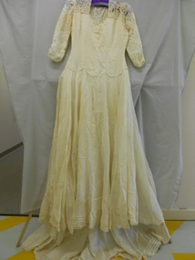
Clothing - HELEN MUSK COLLECTION: CREAM WEDDING DRESS
Full length cream synthetic fabric wedding dress with long sleeves and a train. Front and back have a yoke of lace. Three quarter length sleeves are made of the same lace with roulette trim at hem. Inner and outer edges of sleeves ruched for 3 cm. High round neck at back. V neckline at front. Front of bodice has two side darts and two under bust darts. Bodice at waist line has three decorative scallops at front and back. Synthetic fabric of bodice has woven fabric backing. Side opening on left hand side is fastened with nine press studs. Full length skirt of lighter weight opaque synthetic fabric has centre seams at front and back. Fabric is cut on the bias to form a 360? full circle skirt with a train at centre back. An additional section of fabric is attached at either side to complete the circle. At centre back of the skirt is an inverted pleat to create fullness for the train. Hemline is edged with lace with four rows of tucks above the hem, 1 cm apart. Separate petticoat of heavier woven synthetic fabric attached at waist. Petticoat cut on the bias to create 360? full circle skirt with inverted pleat at centre back to create fullness. Narrow turned over hem. Petticoat skirt dips to a V shape at centre front and back seams. Machine stitched.costume, female ceremonial, wedding dress -
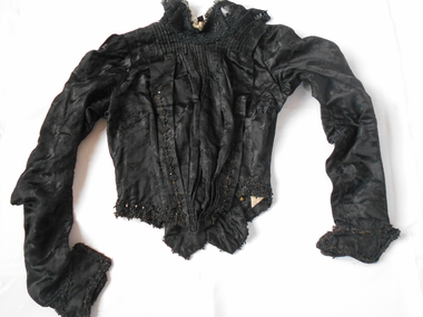 Bendigo Historical Society Inc.
Clothing - GRAYDON COLLECTION: BODICE, 1870-1890
Clothing. Women's black embossed silk bodice. Part of two piece set (skirt 11410.2). Stand up lace collar (7 cm) boned on either side and edged with cream coloured lace. Collar fastened at centre back with three metal hooks and eyes. Front opening left of centre fastened with eight metal hooks and cotton loops and three across the left shoulder. Crossover section at front is pin tucked below the neckline and is tapered into the waist with centre pleats. Both sides of the crossover have decorative beading along the edges. The inner layer of the bodice is fastened at centre front with 15 metal hooks and eyes - alternating directions. The bodice is shaped from the waist with 9 boned casings. The back is shaped in at the waist finishing with two U shaped tails (11cm X 8cm) with V shaped tails (4 cm X 6cm) on either side. The waistline and tails are finished with a double row of decorative black beading. At the waistline at centre back are three metal hooks to attach bodice to skirt. Long sleeves are gathered at the shoulder, shaped at the elbow tapering to the wrist. Below the wrist is a two piece cuff (13cm X 7cm) with decorative black beading. The bodice is fully lined with light brown cotton fabric with grey splash pattern. Historical Notes: This bodice and skirt belonged to Elizabeth Graydon (nee Richardson). Photograph of Elizabeth wearing this outfit (11410.3).costume, female, women's black silk bodice -
Moorabbin Air Museum
Document (item) - Miscellaneous items See list under "Description"
-
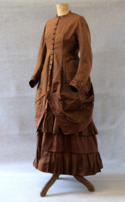 Brighton Historical Society
Clothing - Dress, Day dress, circa 1875-1876
This dress belonged to Ethel Nina Blundell (1876-1949), having been first made for her mother Jane Blundell (nee Burkitt, 1845-1878). Born in Dublin, Jane married James John Blundell Jr at the Black Street Congregational Church in Brighton on 16 March 1874. The Blundells were a socially prominent Brighton family who played an important role in the development of the area. James' father, publisher and bookseller James John Blundell Sr, served as a Brighton Borough Councillor between 1862 and 1867 when the local government was still in its formative years, including holding the position of Mayor in 1864. He was involved in the foundation of the Brighton Volunteer Rifle Corps and was also a strong supporter of the Brighton Ladies Benevolent Society. The Blundell family were active members of the Brighton Congregational Church and supported the construction of the Black Street church, where James Jr served as a deacon for sixty years, in addition to his work in the Crown Land and Survey Department. The dress is believed to have been made for Jane in 1875 or 1876 during her early pregnancy, likely by a local dressmaker. Jane died in 1878 when Ethel was very young, and Ethel was then raised by her father and paternal grandmother. As she never married, Ethel remained living in the family home of 'Eumana', 164 Church Street, and as an adult she assumed the role of hostess whenever she or her father had guests. On these occasions, she reportedly wore her mother's dress. The family home was sold on James Jr’s death in 1924 and Ethel was living at 52 Black Street Brighton when she died in 1949. In the 1930s, Ethel gifted the dress to a close family friend, Dr Jean Kelly. She told Jean that the garment held precious memories, perhaps due to the connection it provided to the mother she had never known. Jean donated the dress to the Merimbula Old School Museum in NSW in 1987, where it was on display for many years. The Museum donated the dress to Brighton Historical Society in 2023.This is a good example of a late nineteenth century day dress, made from two different patterns of russet brown silk brocade and featuring a lobster tail style bustle. The lack of boning combined with waist and hip measurements indicates it may have been made as a maternity dress. It is lined with beige leaf pattern cotton fabric. The princess line fitted bodice of herringbone pattern brocade has a high round neck with small 'mandarin' style collar and buttons down the front to below the waist where it forms an overskirt which is bordered with a band of coffee bean patterned brocade. The overskirt drops down to hem length at the back but from the centre front it is draped up to the back to a point below the waist level. Here it is sewn to the edge of the lobster tail style bustle which is also bordered by the coffee bean fabric. There is a concealed pocket with the opening under the right edge of the bustle. The buttons on the front of the dress have a decorative circlet of small blue flowers around a russet silk covered dome. The long sleeves are set in and slightly full with a contrasting three pleat band of coffee bean fabric with an ornamental turn back from the pleats sewn just above the wrist. The skirt section of the dress is in four 20 cm bands of alternate fabric patterns with the top and third band of coffee bean pattern slightly gathered and the second and fourth bands of herringbone forming pleated ruffles.1870s, ethel nina blundell, jane blundell, jane burkitt, eumana