Showing 9694 items matching "merry-go-round"
-
 Bialik College
Audio (Item) - Born to Shine, 2000
Audio recording created as part of Bialik College's music program, in 2000. Included primary and senior school students. Please contact [email protected] to request access to this record.Bialik College Born to Shine1. Guajira- Funk Band with Amazon Rhythms 2. Old Fashioned- Highly Strung, 3. Az Der Rabbe- Weenyboppers, 4. Tumbalalaika- Weenyboppers, 5. Ostinato- Jungle Juice, 6. For Whom the Bell Tolls, Year 10 Band, 7. Live Wire- Highly Strung, 8. Hello Goodbye- Pipsqueakers, 9. Obladi Oblada- Pipsqueakers, 10. Born to Shine- Year 9 Band (1), 11. Saturn- Amazon Rythms, 12. Gabrielle- Teenyboppers, 13. When eh Sun Goes Down, Senior Band, 14. Foolish Games- Year 9 Band (2), 15. Cherish- Senior Vocal Ensemble, 16. Fade to Black - Year 10 Band, 17. Hard to Say I'm Sorry- Senior Vocal Ensemble, 18. I'm Not Talking to You- Pipsqueakers. 2000s, 2000, primary school, year 10, year 9, music, assessment, bialik college -
 The Beechworth Burke Museum
Audio - Oral History, Jennifer Williams, Mr Albert (Bert) Nankervis, 15th March 2000
Mr Albert (Bert) Nankervis was born at Thougla, in the Upper Murray, in 1903. He had a large family and was one of eight children, four boys and four girls. He and his family moved to a farm in Wooragee named ‘Wattle Grove’ in 1918 after his father returned from serving as a soldier in World War One. The family established ‘Wattle Grove’ as a dairy farm as Beechworth has a high demand for milk and little supply. They had 25 milk cows that were hand milked every morning in order to provide milk for approximately 100 customers in the town, with any extra going to the butter factory at Springhurst. Albert married Floré Lilias Hardy in 1930 and they had two sons, Phillip and Barry. In this oral history, Albert discusses his life as a farmer in Wooragee, including his role in getting electricity to Beechworth, as well as his participation in the Young Farmer’s Association Immigration Scheme, which provided work experience to migrants in order for them to learn how to farm. This oral history recording was part of a project conducted by Jennifer Williams in the year 2000 to capture the everyday life and struggles in Beechworth during the twentieth century. This project involved recording seventy oral histories on cassette tapes of local Beechworth residents which were then published in a book titled: Listen to what they say: voices of twentieth century Beechworth. These cassette tapes were digitised in July 2021 with funds made available by the Friends of the Burke. Mr Albert (Bert) Nankervis’s account of his life in Wooragee and the local area, including Beechworth, during the early 20th century is historically and socially significant to the cultural heritage of the region. He details his life as a farmer and milkman in the early 20th century, particularly the interwar period (1918-1939), but also discusses life after the Second World War, including employing young migrant men to train them as farmers through the Young Farmer’s Association. This oral history account is socially and historically significant as it is a part of a broader collection of interviews conducted by Jennifer Williams which were published in the book 'Listen to what they say: voices of twentieth-century Beechworth.' While the township of Beechworth is known for its history as a gold rush town, these accounts provide a unique insight into the day-to-day life of the town's residents during the 20th century, many of which will have now been lost if they had not been preserved. This is a digital copy of a recording that was originally captured on a cassette tape. The cassette tape is black with a horizontal white strip and is currently stored in a clear flat plastic rectangular container. It holds up 45 minutes of recordings on each side.Mr Albert (Bert) Nankervis / albert nankervis, bert nankervis, nankervis, wattle grove, wooragee, dairy farm beechworth, dairy farm, dairy factories beechworth, dairying, milkman, oral history, springhurst, butter factory, electricity, rural life, farming and agriculture, farm, farm work, cow, cattle, jersey cattle, interwar period, first world war, second world war, wwi, wwii, greatest generation, centenarian, nonagenarian, 1920s, 1930s beechworth, thougla, upper murray, murray, lucyvale, benalla -
 Flagstaff Hill Maritime Museum and Village
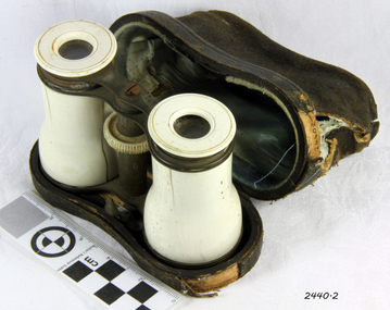
Opera Glasses & case, Early 20th Century
Opera Glasses came into existence as a result of a long line of inventions, and further improvements upon those inventions. The process started in the year 1608 when a Dutch optician by the name of Hans Lipperhey developed the first pair of binoculars with a magnification capability of X3. Less than a year later, a well-known inventor and philosopher by the name of Galileo developed what became known as the Galilean telescope. Advertisements were first found for opera glasses and theatre binoculars in London as early as 1730 in the form of a long collapsible telescope. The "Opera Glass" as it was referred to; was often covered in enamel, gems, ivory, or other art and paintings. For almost 100 years opera glasses existed merely as telescopes. In Vienna, in 1823 the first binocular opera glasses and theatre binoculars began to appear. They were two simple Galilean telescopes with a bridge in the centre, each telescope focused independently from the other by extending or shortening the telescope until the desired focus was achieved, which was useful, yet very cumbersome. Two years later in Paris, Pierre Lemiere improved on this design and created a centre focus wheel. This allowed the focusing of both telescopes together. After this development, opera glasses and theatre binoculars grew in popularity because of the superior view they facilitated in opera and theatre houses. The beautiful design of the glasses themselves also added appeal to the opera-going crowd. By the 1850's opera glasses and theatre, glasses had become a must-have fashion accessory for all opera and theatergoers.Not very significant as not associated with a historic event or person and made during the first half of the 20th Century and many are still available and easily sourced.Vintage Pair of Opera Glasses, with cow bone barrels and eyepieces, both barrel pieces have split in them, both metal end barrels each have a minor dent, optics are pretty clear no mould although have very minor dust spots inside, they look like they were gilded at some point but most of this has rubbed off glasses have a black leather case with blue lining. No markings whatsoever anywhereflagstaff hill, warrnambool, shipwrecked coast, flagstaff hill maritime museum, maritime museum, shipwreck coast, flagstaff hill maritime village, great ocean road, binoculars, opera glasses, theatre glasses, optical instrument, cow bone -
 Flagstaff Hill Maritime Museum and Village
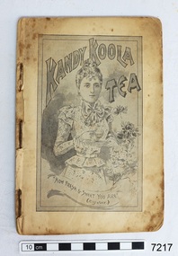
Book - Cookbook, The Kandy Koola Cookery Book, 1898
This is a cookbook of family recipes and promotes products available for purchase at that time. The products include Kandy Koola, Nestle, Usher’s Whiskey and O.K. Kandy Koola ran an advertisement in the West Gippsland Gazette on 2 May 1911 promoting its tea as perfect for a picnic. The text reads “Picnicking. All as hungry as hunters – made a fire of small twigs – put on our billy of fresh spring water – and waited. Soon bubble, bubble, bubble and the billy boiled. In goes the pure Kandy-Koola Tea. Tea! Tea is not the word – it tasted like nectar! One cup, two cups, three cups – then had to make a fresh billy full. Lazed away the rest of the day sipping our Kandy Koola and chatting. How good indeed! “All grocers sell Kandy Koola Tea. It is pure leaf, selected and blended with the greatest care and skill. Ask your grocer for Kandy Koola . Sold in three grades, i.e. red, blue and green packets” A copy of this cookery book is in the Monash University Library’s Rare Books Collection and has a cover with red printing on a cream background. The price stamp on the corner of the cover is “One Shilling” and is under an image of a crown. The book has 71 pages. It is listed as being published in Melbourne, 1898. The comment given is “This is an early example of an Australian cookbook printed as a product promotion, ‘published by the proprietors of Kandy Koola Tea for presentation to the ladies of Victoria, with compliments.’ “ Flagstaff Hill also has a green Kandy Koola Tea tin in our Collection This Kandy Koola Cookery Book is an example of the recipes, foods, manufacturers, advertisements available and used in the late 19th century in Australia’s colonial times. Food types, preparation and cooking methods show those available to housewives in those times.Book, cookbook, The Kandy Koola Cookery Book and Housewife’s Companion. Small book, pages bound with staples, contained in a black card cover (original outer covers is missing). Pages start at number 11, which is an advertisement for Kandy Koola Tea. The book includes a wide variety of recipes promoting products of Kandy Koola, Nestle, Usher’s Whiskey and O.K. There are pages of line drawings of a ‘Chinese Tea Plantation’ and ‘Natural Bridge in Virginia U.S.A.’ Advertisements include a drawing of a kangaroo. flagstaff hill, warrnambool, shipwrecked coast, flagstaff hill maritime museum, maritime museum, shipwreck coast, flagstaff hill maritime village, great ocean road, cookery book, cookbook, australian cookbook, 19th century cookbook, colonial cookbook, domestic, book, promotional cookbook, o.k. preserves manufacturer, nestle, usher’s whiskey, image of chinese tea plantation, image of natural bridge in virginia u.s.a., cook book, kandy koola cookery book -
 Eltham District Historical Society Inc
Postcard - Photograph postcard, The Rapids, Devils' Bank, Eltham, 1907
Devils' Bank was situated some two miles from Eltham. It is probably the section along the Yarra River where there are a series of rapids stretching past Petty's Orchard to Griffiths Park and the confluence with the Diamond Creek. Only three properties existed in this area in 1945 aerial maps, Worlingworth and the adjoining property on the bank of the Diamond Creek in Banoon Road and No. 2 Kent Hughes Road. Devils' Bank. The death of Ann Edwards, 77 years, an old resident of the district was reported who lived in an old hut at Devil's Bank who had been found dead in her bed on 13 May 1897 FOUND DEAD IN BED. (1897, May 28). Evelyn Observer, and South and East Bourke Record (Vic. : 1882 - 1902), p. 2 (MORNING.). Retrieved September 3, 2022, from http://nla.gov.au/nla.news-article60696388 A very similar view was published in the Leader paper in January 1908 - Devil's Bank Falls, Eltham VIEWS ON THE UPPER YARRA. (1908, January 11). Leader (Melbourne, Vic. : 1862 - 1918, 1935), p. 28. Retrieved September 3, 2022, from http://nla.gov.au/nla.news-article198106006 On the reverse of the postcard it appears to be postmarked Eltham, Dec 27, 1907 addressed to Mrs Christie Millmoss of Bull Street, Bendigo "Arrived here 10.45 am - ? ? raining cause of ? - ? till evenings it is lovely - but quite fresh after the (rain - crossed out) great ? - I may assume it all go well"Digital file only Postcards scanned from the collection of Michael Aitken on loan to EDHS, 2 Sep. 2022michael aitken collection, devils bank, eltham, postcards, rapids, yarra river -
 Eltham District Historical Society Inc
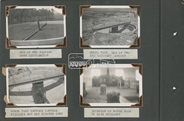
Album - Photograph Album, Alan Gardiner, M.M.B.W Braeside Sewage Treatment Plant Construction, 1939
In April 1928 the MMBW had the land and the plans for what they were to construct but the timing of the actual building did not proceed as planned. Before the construction could commence the Great Depression of the 1930s intervened forcing the shelving of its plans. The new owners then offered the land for lease resulting in Frederick Werrett taking the opportunity to take up the land he formerly owned to continue his market gardening activities of growing potatoes, onions and other crops. The land and improvements made by Syme were leased in 1929 to Harry Telford a trainer from New South Wales. Phar Lap grazed there for a short time. [9] However the population of Melbourne continued to grow and the need for a sewerage treatment plant did not go away. In 1939 when the effects of the Depression had dissipated work on the Sewerage Effluent Treatment Plant commenced and the following year in October the Premier of the State, Albert Dunstan, officially commissioned it. The Sewerage Effluent Treatment Plant at Braeside served the communities of south-east Melbourne for thirty five years until 1975. In that year all the sewers that entered the Braeside plant were diverted to the South Eastern Trunk Sewer complex at Carrum.[10] In 1982 the chairman of the MMBW at that time, Alan Croxford, announced that a substantial part of the property at Braeside would be administered by the Parks and Gardens section of MMBW as a public park. Subsequently the responsibilities were transferred to Parks Victoria, the situation that exists today. It is known as “Braeside Park” now. [Source: Sewerage Treatment Plant at Braeside, Kingston Local History, https://localhistory.kingston.vic.gov.au/articles/407]alan gardiner collection, 1939, braeside sewage treatment plant, construction, melbourne metropolitan board of works, mmbw -
 Eltham District Historical Society Inc
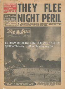
Newspaper - Newspaper articles, Sun News-Pictorial, They Flee Night Peril, The Sun News-Pictorial, Wednesday, January 17, p1, 1962
Various news articles pertaining to the January 1962 Victorian bushfires in the Dandenong and Healesville districts which by the third day had encompassed large areas of the State. Specific Eltham Shire districts mentioned include Panton Hill and Hurstbridge on page 1, Warrandyte on page 2, 3, 4 and 5, Hurstbridge, Smith’s Gully, Kinglake on page 3 and 4, Strathewen, Kangaroo Ground, Panton Hill, St. Andrews, Smith’s Gully on page 4 and Pound Bend, Smith’s Gully and Warrandyte on pages 20-21 • They Flee Night Peril, p1 (Illust.) • Their grim picnic; A flash fire strikes, p2 (Illust.) • Night of terror as towns quitted, p3 • Fought till he dropped, p3 (Illust.) • Rain in fire area, p3 • Wye River town goes, p3 • Black Friday Hero Dies In Fire; with wife, grandsons, p4 • Surrounded!, p4 (Illust.) • Main street houses ablaze, p4 • Hurstbridge is evacuated, p4 • Scores jump in river at Warrandyte, p5 • Hills people leave homes, p5 • “Fire” cry at Parlt., p5 • Blind – he’s safe now, p5 (Illust.) • Police Chief Runs Battle, p7 • From Fire Front: Hospital treats 34, p7 • Firms send help, p7 • Tragedy and Ruin: Third Day; Ferntree Gully; Warrandyte; Pound Bend; Smiths Gully; Escape for 18, pp20-21 (Illust.) • Church was a haven for the hurt, weary, p39 (Illust.) • A home is lost, p40 (Illust.) tom fielding collection, victorian bushfires - 1962, victorian bushfires – 1962, panton hill, hurstbridge, five ways crossroads, warrandyte south, dandenongs, upwey, mt. evelyn, monbulk, olinda, sassafras, st. andrews, warrandyte, christmas hills, yarra river, mitcham, whitehorse roiad, donvale, park orchards, metropolitan fire chief, w.t. aldridge, loughnan’s hill, ringwood, woori yallock, leslie ockwell, linda ockwell, kalorama, healesville, daylesford, fire damage – buildings, wye river, portland, eganstown, ballarat, sherbrooke park forest, forest commission headquarters, kallista, r.t. seaton, montrose, yallourn, central gippsland, smith’s creek, black friday, geoffrey ockwell, ronald ockwell, preston town hall, e.j. tenner, strathewen, kangaroo ground, eric farnsworth, adele farnsworth, robin farnsworth, roy cleland, ann cleland, belgrave, sassfras, kaloramalice commissioner porter, mansfield, box hill hospital, pound bend, ferntree gully, ferntree gully state school, w. carew, ann quinton -
 Eltham District Historical Society Inc
Film - Video (Digital), Geoff Paine, St Margaret's Church, Eltham: Stories of the Nillumbik Shire with Geoff Paine, June 2020
One of a series of videos "Stories from the Nillumbik Shire with Geoff Paine" Geoff Sandy, Parish Historian and Archivist gives a history of the church which was opened 12 December 1861. It is constructed of polychrome bricks (lots of different colours). References a long relationship of over 159 years between the church committee and the Eltham Hotel across the road for refeshments for church events. The land was donated by Henry Dendy, the founder of Brighton where he lived for five years before going bankrupt and moving to Eltham where he bought a steam powered flour mill on the banks of the Diamond Creek at the end of Pitt Street. The church is heritage protected as well as the 1870 parsonage, Dendy House. It was always meant to be a much bigger church and extended along the north wall. This was finally achieved in 2014. Shows views inside of the original section and the extension. Also discusses the original tall windows on the south with gold trimming and other windows with gold trimming. Some original windows have been replaced by stained glass. Discussion about the Patron Saint of the Church, Margaret of Scotland. The original window made for £1 by Yuri and Fergusson in Melbourne and possibly one of the first made in the Colony of Victoria was relocated to the north wall during the 2014 extension. The crucifix was made by Matcham Skipper. Also features the Honour Roll. The walls of the extension are mudbrick, timber from a variety of sources and very much in keeping of the character of Eltham. The bell and bell tower are original. At the end of the First World War the bell was rung so vigorously that the bell broke.MP4 Digital file 00:05:48; 672MBvideo recording, church bell, dendy house, eltham, eltham hotel, flour mill, geoff sandy, henry dendy, honour roll, matcham skipper, mudbrick construction, pitt street, st margaret's anglican church, stained glass -
 Eltham District Historical Society Inc
Booklet - Folder, Raynes Dickson Kiddle & Briggs Solicitors et al, Clintons Road, Christmas Hills, 1934-1938
Correspondence over a four year period (probably an incomplete file) on the behalf of Henry Cairns of Moonee Ponds and property owner at Christmas Hills / Watsons Creek including copy of a survey of his land title in relation to complaint regarding the Shire of Eltham encroaching on his land to make a road and subsequent purchase of land. The road provided acccess to the property of Mr W. Clinton of Heidelberg and other properties at Christmas Hills. Note by H.G. indicates that the property discussed in file is Clintons Road (not stated in file), possibly named after 1938. In December 1937 Eltham Shire Council agreed to purchase a block of land at the intersection of the Christmas Hills -- Smiths Gully roads from Mr Cairns to provide an outlet for the road which ran through the Cairns property. In March 1928 Mr Clinton had previously offered to contribute a sum of money towards the cost of purchasing the Cairns block to permit the road to go into his property was intending to transfer the property to himself. A Councilor was reported as being astounded in The Advertiser, 11 March 1938, as the land was needed for a road. Cr Baird: "The road was only to help his sports" Mr W. E. Clinton (Bill) was one of the founders of the Rob Roy Hill climb which took place at his property at Christmas Hills. He owned a garage in Heidleberg (See: https://cv.vic.gov.au/stories/sporting-life/speed-style-spirit-the-rob-roy-hillclimb/the-rob-roy-hillclimb/)16 pieces of paperraynes dickson kiddle & briggs solicitors, henry cairns, shire of eltham, roadworks, christmas hills, watsons creek, w. e. clinton, clintons road, rob roy climb -
 Eltham District Historical Society Inc
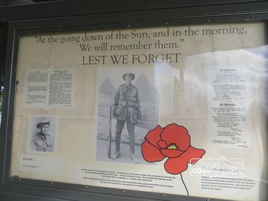
Photograph, Liz Pidgeon, Moor-Rul Viewing Platform Panel: Lest We Forget, 10 August 2016
Includes photograph of WW1 local enlistment John Bell. The Moor-Rul Viewing Platform, part of the Kangaroo Ground War Memorial Park opened in April 2007. Eight double-sided interpretation panels on the Moor-rul viewing platform highlight the area's Aboriginal and European history of the area and also details of local geology, flora and fauna. These panels feature high quality graphic design and professionally written text. The subjects covered are: ''Womin Je Ka" Welcome The Kulin Nation Singing, Dancing, Ceremony, Celebration This Country, My Home The Highland Taken Auld Lang Syne "Same Land Different Views" Working the Land Food from the Earth or "Earth's Harvest" Lest We Forget, "And with the going down of the Sun .... (3 panels) This Black Earth Those other indigenous inhabitants - Kangaroo Ground's Wildlife Silent Witnesses - Kangaroo Ground's White Manna Gums Belonging A Place of Reverence and A Tower of Strength Souce: EDHS Newsletter No 173 March 2007. As part of a program to acknowledge the Anzac Centenary Nillumbik Shire Council partnered with Yarra Plenty Regional Library to provide a bus tour with commentary of local sites of significance: Shire of Nillumbik World War One Memorials tour, 10 August 2016. These included Eltham township, the Shire of Eltham War Memorial at Kangaroo Ground, Christmas Hills war memorial, Hurstbridge memorial recreation park and finshed at Eltham Library to view the Writing the War exhibtion at Eltham Library Community Gallery.Born Digitalworld war 1, war memorials, shire of nillumbik, moor-rul viewing platform, interpretation panel, interpretative signage, lest we forget, shire of eltham war memorial, john bell, display panel -
 Eltham District Historical Society Inc
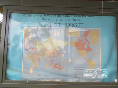
Photograph, Liz Pidgeon, Moor-Rul Viewing Platform Panel: Lest We Forget, 10 August 2016
Coloured map of the world on blue including the words for the "Lest We Forget" lament. The Moor-Rul Viewing Platform, part of the Kangaroo Ground War Memorial Park opened in April 2007. Eight double-sided interpretation panels on the Moor-rul viewing platform highlight the area's Aboriginal and European history of the area and also details of local geology, flora and fauna. These panels feature high quality graphic design and professionally written text. The subjects covered are: ''Womin Je Ka" Welcome The Kulin Nation Singing, Dancing, Ceremony, Celebration This Country, My Home The Highland Taken Auld Lang Syne "Same Land Different Views" Working the Land Food from the Earth or "Earth's Harvest" Lest We Forget, "And with the going down of the Sun .... (3 panels) This Black Earth Those other indigenous inhabitants - Kangaroo Ground's Wildlife Silent Witnesses - Kangaroo Ground's White Manna Gums Belonging A Place of Reverence and A Tower of Strength Souce: EDHS Newsletter No 173 March 2007. As part of a program to acknowledge the Anzac Centenary Nillumbik Shire Council partnered with Yarra Plenty Regional Library to provide a bus tour with commentary of local sites of significance: Shire of Nillumbik World War One Memorials tour, 10 August 2016. These included Eltham township, the Shire of Eltham War Memorial at Kangaroo Ground, Christmas Hills war memorial, Hurstbridge memorial recreation park and finshed at Eltham Library to view the Writing the War exhibtion at Eltham Library Community Gallery. Born Digitalworld war 1, war memorials, shire of nillumbik, moor-rul viewing platform, kangaroo ground, shire of eltham war memorial, interpretative signage, interpretation panel, map, display panel -
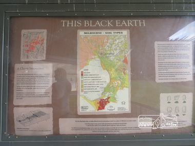 Eltham District Historical Society Inc
Photograph, Liz Pidgeon, Moor-Rul Viewing Platform Panel: This Black Earth, 10 August 2016
"Melbourne soil types" The Moor-Rul Viewing Platform, part of the Kangaroo Ground War Memorial Park opened in April 2007. Eight double-sided interpretation panels on the Moor-rul viewing platform highlight the area's Aboriginal and European history of the area and also details of local geology, flora and fauna. These panels feature high quality graphic design and professionally written text. The subjects covered are: ''Womin Je Ka" Welcome The Kulin Nation Singing, Dancing, Ceremony, Celebration This Country, My Home The Highland Taken Auld Lang Syne "Same Land Different Views" Working the Land Food from the Earth or "Earth's Harvest" Lest We Forget, "And with the going down of the Sun .... (3 panels) This Black Earth Those other indigenous inhabitants - Kangaroo Ground's Wildlife Silent Witnesses - Kangaroo Ground's White Manna Gums Belonging A Place of Reverence and A Tower of Strength Souce: EDHS Newsletter No 173 March 2007. As part of a program to acknowledge the Anzac Centenary Nillumbik Shire Council partnered with Yarra Plenty Regional Library to provide a bus tour with commentary of local sites of significance: Shire of Nillumbik World War One Memorials tour, 10 August 2016. These included Eltham township, the Shire of Eltham War Memorial at Kangaroo Ground, Christmas Hills war memorial, Hurstbridge memorial recreation park and finshed at Eltham Library to view the Writing the War exhibtion at Eltham Library Community Gallery.Born Digitalshire of nillumbik, moor-rul viewing platform, interpretative signage, interpretation panel, display panel -
 Eltham District Historical Society Inc
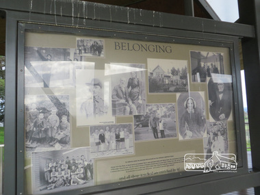
Photograph, Liz Pidgeon, Moor-Rul Viewing Platform Panel: Belonging, 10 August 2016
Collage of black and white historical photographs of people. The Moor-Rul Viewing Platform, part of the Kangaroo Ground War Memorial Park opened in April 2007. Eight double-sided interpretation panels on the Moor-rul viewing platform highlight the area's Aboriginal and European history of the area and also details of local geology, flora and fauna. These panels feature high quality graphic design and professionally written text. The subjects covered are: ''Womin Je Ka" Welcome The Kulin Nation Singing, Dancing, Ceremony, Celebration This Country, My Home The Highland Taken Auld Lang Syne "Same Land Different Views" Working the Land Food from the Earth or "Earth's Harvest" Lest We Forget, "And with the going down of the Sun .... (3 panels) This Black Earth Those other indigenous inhabitants - Kangaroo Ground's Wildlife Silent Witnesses - Kangaroo Ground's White Manna Gums Belonging A Place of Reverence and A Tower of Strength Souce: EDHS Newsletter No 173 March 2007. As part of a program to acknowledge the Anzac Centenary Nillumbik Shire Council partnered with Yarra Plenty Regional Library to provide a bus tour with commentary of local sites of significance: Shire of Nillumbik World War One Memorials tour, 10 August 2016. These included Eltham township, the Shire of Eltham War Memorial at Kangaroo Ground, Christmas Hills war memorial, Hurstbridge memorial recreation park and finshed at Eltham Library to view the Writing the War exhibtion at Eltham Library Community Gallery.Born Digitalshire of nillumbik, moor-rul viewing platform, kangaroo ground, interpretative signage, interpretation panel, display panel -
 Eltham District Historical Society Inc
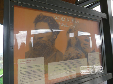
Photograph, Liz Pidgeon, Moor-Rul Viewing Platform Panel: Womin Je Ka "Welcome", 10 August 2016
Welcome panel including information on William Barak. The Moor-Rul Viewing Platform, part of the Kangaroo Ground War Memorial Park opened in April 2007. Eight double-sided interpretation panels on the Moor-rul viewing platform highlight the area's Aboriginal and European history of the area and also details of local geology, flora and fauna. These panels feature high quality graphic design and professionally written text. The subjects covered are: ''Womin Je Ka" Welcome The Kulin Nation Singing, Dancing, Ceremony, Celebration This Country, My Home The Highland Taken Auld Lang Syne "Same Land Different Views" Working the Land Food from the Earth or "Earth's Harvest" Lest We Forget, "And with the going down of the Sun .... (3 panels) This Black Earth Those other indigenous inhabitants - Kangaroo Ground's Wildlife Silent Witnesses - Kangaroo Ground's White Manna Gums Belonging A Place of Reverence and A Tower of Strength Souce: EDHS Newsletter No 173 March 2007. As part of a program to acknowledge the Anzac Centenary Nillumbik Shire Council partnered with Yarra Plenty Regional Library to provide a bus tour with commentary of local sites of significance: Shire of Nillumbik World War One Memorials tour, 10 August 2016. These included Eltham township, the Shire of Eltham War Memorial at Kangaroo Ground, Christmas Hills war memorial, Hurstbridge memorial recreation park and finshed at Eltham Library to view the Writing the War exhibtion at Eltham Library Community Gallery. Born Digitalshire of nillumbik, memorial park, kangaroo ground, interpretative signage, indigenous history, moor-rul viewing platform, william barak, display panel -
 Eltham District Historical Society Inc
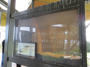
Photograph, Liz Pidgeon, Moor-Rul Viewing Platform Panel: A Place of Reverence and a Tower of Strength, 10 August 2016
The Moor-Rul Viewing Platform, part of the Kangaroo Ground War Memorial Park opened in April 2007. Eight double-sided interpretation panels on the Moor-rul viewing platform highlight the area's Aboriginal and European history of the area and also details of local geology, flora and fauna. These panels feature high quality graphic design and professionally written text. The subjects covered are: ''Womin Je Ka" Welcome The Kulin Nation Singing, Dancing, Ceremony, Celebration This Country, My Home The Highland Taken Auld Lang Syne "Same Land Different Views" Working the Land Food from the Earth or "Earth's Harvest" Lest We Forget, "And with the going down of the Sun .... (3 panels) This Black Earth Those other indigenous inhabitants - Kangaroo Ground's Wildlife Silent Witnesses - Kangaroo Ground's White Manna Gums Belonging A Place of Reverence and A Tower of Strength Souce: EDHS Newsletter No 173 March 2007. This panel includes a frame of an eagle feather. See ID 02224-47 As part of a program to acknowledge the Anzac Centenary Nillumbik Shire Council partnered with Yarra Plenty Regional Library to provide a bus tour with commentary of local sites of significance: Shire of Nillumbik World War One Memorials tour, 10 August 2016. These included Eltham township, the Shire of Eltham War Memorial at Kangaroo Ground, Christmas Hills war memorial, Hurstbridge memorial recreation park and finshed at Eltham Library to view the Writing the War exhibtion at Eltham Library Community Gallery.Born Digitalshire of nillumbik, kangaroo ground, moor-rul viewing platform, interpretative signage, interpetation panel, display panel -
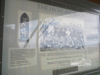 Eltham District Historical Society Inc
Photograph, Liz Pidgeon, Moor-Rul Viewing Platform Panel: The Highland Taken, 10 August 2016
"The Scots were the first Europeans to farm this place". The Moor-Rul Viewing Platform, part of the Kangaroo Ground War Memorial Park opened in April 2007. Eight double-sided interpretation panels on the Moor-rul viewing platform highlight the area's Aboriginal and European history of the area and also details of local geology, flora and fauna. These panels feature high quality graphic design and professionally written text. The subjects covered are: ''Womin Je Ka" Welcome The Kulin Nation Singing, Dancing, Ceremony, Celebration This Country, My Home The Highland Taken Auld Lang Syne "Same Land Different Views" Working the Land Food from the Earth or "Earth's Harvest" Lest We Forget, "And with the going down of the Sun .... (3 panels) This Black Earth Those other indigenous inhabitants - Kangaroo Ground's Wildlife Silent Witnesses - Kangaroo Ground's White Manna Gums Belonging A Place of Reverence and A Tower of Strength Souce: EDHS Newsletter No 173 March 2007. As part of a program to acknowledge the Anzac Centenary Nillumbik Shire Council partnered with Yarra Plenty Regional Library to provide a bus tour with commentary of local sites of significance: Shire of Nillumbik World War One Memorials tour, 10 August 2016. These included Eltham township, the Shire of Eltham War Memorial at Kangaroo Ground, Christmas Hills war memorial, Hurstbridge memorial recreation park and finshed at Eltham Library to view the Writing the War exhibtion at Eltham Library Community Gallery.Born Digitalshire of nillumbik, kangaroo ground, moor-rul viewing platform, interpretative signage, interpretation panel, indigenous history, display panel, early settlers -
 Eltham District Historical Society Inc
Photograph, Main Road, Eltham South, near Eltham Park, flooded by the Diamond Creek, 30 Nov. 1934
Near Eltham Park (now known as Eltham Lower Park), floodwaters from the Diamond Creek cut off the Main road into Eltham at Bremner’s Flats (present day Wingrove Park). In the distance, left of centre, is Mr. Montieth's Ford Wagonette stranded in the floodwater near Wingrove Cottage. “On the Lower Eltham Reserve the water was nearly five feet deep across the reserve and over a mile along the road. All the week-end shops are surrounded. For over 40 years flood waters have not reached this unprecedented level.” - Advertiser, Friday November 30, 1934, p7 "Whilst we were at the shop a "tidal" wave occured . There used to be a Mr. Monteith who ran a Model T Ford bus from the Eltham Railway Station down the main street. The bus would hold seven, six seated in the back, 3 aside a seventh standing on the step on the middle of the back hanging on to two small hand rails. The bus was caught by the flood and was abandoned not far from our shop in the paddocks towards the Higher Elementary School. It was there for days and after the flood waters receded, Mr. Monteith, after removing all the mud and debris gave the engine one turn with the handle and it started first time! So the story goes! " (Doug Orford Reminiscences, 2004) The 1934 flood of the Diamond Creek and Yarra River is the highest recorded flooding in the district and set the standard for the current planning flood plain level.Black and white photograph showing the floodwater from Diamond Creek across Main Road in 1934. Left of centre shows Mr. Montieth's Ford Wagonette in the floodwater in the distancefloods, main road, eltham south, diamond creek (creek), wingrove cottage, wingrove park, bus services, bremner's flat, eltham park, ford wagonette, mr. montieth, floodwater, reminscences -
 Eltham District Historical Society Inc
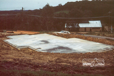
Photograph, Land size highlighted by Tiny and Carla Vermey standing at each corner, 1979
14 Stokes Place (Lot 83) was the home of Peter and Carla Vermey. The land was purchased in May 1979 and construction commenced September 1979. The home was built by Peter and Carla Vermey after the developer, Macquarie Builders went bankrupt. Sold October 2017 by Morrison and Kleeman Real Estate. Stokes Place was part of the Stokes Orchard Estate which was developed from the break-up of the the orchard owned by Frank Stokes who lived on the northeast corner of Nyora Road and Eucalyptus Road. His daughter Beryl advised that the Shire had levied a rate assessment on individual parcels of land within the orchard which became unaffordable resulting in its sub-division and sell off. The Stokes Orchard Estate was developed by Macquarie Builders in two stages starting with stage 1 in 1976. Stokes Place was part of Stage 2 in 1979. The Estate was bounded between Nyora Road, Eucalyptus Road, Diosma Road and Stokes Place. The original orchard only just reached the left most portions of Stokes Place and did not go fully up to Diosma, rather to just beyond the extant of Stokes Place. Stokes Place was known within the family as "The Oats" as that is where they grew oats. Frank Stokes moved to Eltham c.1945 after visiting Harold Bird to view his orchard, located diagonally opposite Stokes Orchard from the intersection of Eucalyptus Road, Pitt Street and Nyora Road. It was on Harold Bird's recommendation that Frank purchased the land.The Stokes Orchard Estate collection is typical of housing developments of the late 1970s and 1980s. It was one of the earliest estates in Eltham following the nearby Woodridge Estate development.Digital fileScanned by EDHS from 49 x 35mm colour transparencies provided on loanstokes place, eltham, stokes orchard, stokes orchard estate, streets, houses, peter and carla vermey -
 Eltham District Historical Society Inc
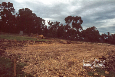
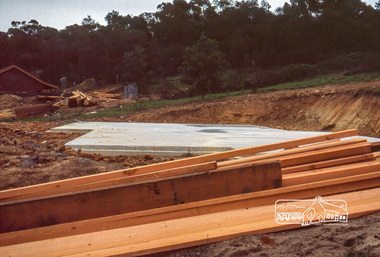
Photograph, Excavation of dwelling, 1979
14 Stokes Place (Lot 83) was the home of Peter and Carla Vermey. The land was purchased in May 1979 and construction commenced September 1979. The home was built by Peter and Carla Vermey after the developer, Macquarie Builders went bankrupt. Sold October 2017 by Morrison and Kleeman Real Estate. Stokes Place was part of the Stokes Orchard Estate which was developed from the break-up of the the orchard owned by Frank Stokes who lived on the northeast corner of Nyora Road and Eucalyptus Road. His daughter Beryl advised that the Shire had levied a rate assessment on individual parcels of land within the orchard which became unaffordable resulting in its sub-division and sell off. The Stokes Orchard Estate was developed by Macquarie Builders in two stages starting with stage 1 in 1976. Stokes Place was part of Stage 2 in 1979. The Estate was bounded between Nyora Road, Eucalyptus Road, Diosma Road and Stokes Place. The original orchard only just reached the left most portions of Stokes Place and did not go fully up to Diosma, rather to just beyond the extant of Stokes Place. Stokes Place was known within the family as "The Oats" as that is where they grew oats. Frank Stokes moved to Eltham c.1945 after visiting Harold Bird to view his orchard, located diagonally opposite Stokes Orchard from the intersection of Eucalyptus Road, Pitt Street and Nyora Road. It was on Harold Bird's recommendation that Frank purchased the land.The Stokes Orchard Estate collection is typical of housing developments of the late 1970s and 1980s. It was one of the earliest estates in Eltham following the nearby Woodridge Estate development.Digital fileScanned by EDHS from 49 x 35mm colour transparencies provided on loanstokes place, eltham, stokes orchard, stokes orchard estate, streets, houses, peter and carla vermey -
 Eltham District Historical Society Inc
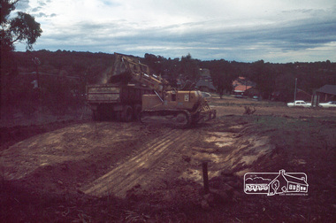
Photograph, Excavation of garage, 1979
14 Stokes Place (Lot 83) was the home of Peter and Carla Vermey. The land was purchased in May 1979 and construction commenced September 1979. The home was built by Peter and Carla Vermey after the developer, Macquarie Builders went bankrupt. Sold October 2017 by Morrison and Kleeman Real Estate. Stokes Place was part of the Stokes Orchard Estate which was developed from the break-up of the the orchard owned by Frank Stokes who lived on the northeast corner of Nyora Road and Eucalyptus Road. His daughter Beryl advised that the Shire had levied a rate assessment on individual parcels of land within the orchard which became unaffordable resulting in its sub-division and sell off. The Stokes Orchard Estate was developed by Macquarie Builders in two stages starting with stage 1 in 1976. Stokes Place was part of Stage 2 in 1979. The Estate was bounded between Nyora Road, Eucalyptus Road, Diosma Road and Stokes Place. The original orchard only just reached the left most portions of Stokes Place and did not go fully up to Diosma, rather to just beyond the extant of Stokes Place. Stokes Place was known within the family as "The Oats" as that is where they grew oats. Frank Stokes moved to Eltham c.1945 after visiting Harold Bird to view his orchard, located diagonally opposite Stokes Orchard from the intersection of Eucalyptus Road, Pitt Street and Nyora Road. It was on Harold Bird's recommendation that Frank purchased the land.The Stokes Orchard Estate collection is typical of housing developments of the late 1970s and 1980s. It was one of the earliest estates in Eltham following the nearby Woodridge Estate development.Digital fileScanned by EDHS from 49 x 35mm colour transparencies provided on loanstokes place, eltham, stokes orchard, stokes orchard estate, streets, houses, peter and carla vermey -
 Eltham District Historical Society Inc
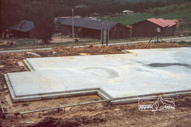
Photograph, Concrete slab from backyard
14 Stokes Place (Lot 83) was the home of Peter and Carla Vermey. The land was purchased in May 1979 and construction commenced September 1979. The home was built by Peter and Carla Vermey after the developer, Macquarie Builders went bankrupt. Sold October 2017 by Morrison and Kleeman Real Estate. Stokes Place was part of the Stokes Orchard Estate which was developed from the break-up of the the orchard owned by Frank Stokes who lived on the northeast corner of Nyora Road and Eucalyptus Road. His daughter Beryl advised that the Shire had levied a rate assessment on individual parcels of land within the orchard which became unaffordable resulting in its sub-division and sell off. The Stokes Orchard Estate was developed by Macquarie Builders in two stages starting with stage 1 in 1976. Stokes Place was part of Stage 2 in 1979. The Estate was bounded between Nyora Road, Eucalyptus Road, Diosma Road and Stokes Place. The original orchard only just reached the left most portions of Stokes Place and did not go fully up to Diosma, rather to just beyond the extant of Stokes Place. Stokes Place was known within the family as "The Oats" as that is where they grew oats. Frank Stokes moved to Eltham c.1945 after visiting Harold Bird to view his orchard, located diagonally opposite Stokes Orchard from the intersection of Eucalyptus Road, Pitt Street and Nyora Road. It was on Harold Bird's recommendation that Frank purchased the land.The Stokes Orchard Estate collection is typical of housing developments of the late 1970s and 1980s. It was one of the earliest estates in Eltham following the nearby Woodridge Estate development.Digital fileScanned by EDHS from 49 x 35mm colour transparencies provided on loanstokes place, eltham, stokes orchard, stokes orchard estate, streets, houses, peter and carla vermey -
 Eltham District Historical Society Inc
Photograph, Concrete slab from driveway
14 Stokes Place (Lot 83) was the home of Peter and Carla Vermey. The land was purchased in May 1979 and construction commenced September 1979. The home was built by Peter and Carla Vermey after the developer, Macquarie Builders went bankrupt. Sold October 2017 by Morrison and Kleeman Real Estate. Stokes Place was part of the Stokes Orchard Estate which was developed from the break-up of the the orchard owned by Frank Stokes who lived on the northeast corner of Nyora Road and Eucalyptus Road. His daughter Beryl advised that the Shire had levied a rate assessment on individual parcels of land within the orchard which became unaffordable resulting in its sub-division and sell off. The Stokes Orchard Estate was developed by Macquarie Builders in two stages starting with stage 1 in 1976. Stokes Place was part of Stage 2 in 1979. The Estate was bounded between Nyora Road, Eucalyptus Road, Diosma Road and Stokes Place. The original orchard only just reached the left most portions of Stokes Place and did not go fully up to Diosma, rather to just beyond the extant of Stokes Place. Stokes Place was known within the family as "The Oats" as that is where they grew oats. Frank Stokes moved to Eltham c.1945 after visiting Harold Bird to view his orchard, located diagonally opposite Stokes Orchard from the intersection of Eucalyptus Road, Pitt Street and Nyora Road. It was on Harold Bird's recommendation that Frank purchased the land.The Stokes Orchard Estate collection is typical of housing developments of the late 1970s and 1980s. It was one of the earliest estates in Eltham following the nearby Woodridge Estate development.Digital fileScanned by EDHS from 49 x 35mm colour transparencies provided on loanstokes place, eltham, stokes orchard, stokes orchard estate, streets, houses, peter and carla vermey -
 Eltham District Historical Society Inc
Photograph, Concrete slab from north elevation
14 Stokes Place (Lot 83) was the home of Peter and Carla Vermey. The land was purchased in May 1979 and construction commenced September 1979. The home was built by Peter and Carla Vermey after the developer, Macquarie Builders went bankrupt. Sold October 2017 by Morrison and Kleeman Real Estate. Stokes Place was part of the Stokes Orchard Estate which was developed from the break-up of the the orchard owned by Frank Stokes who lived on the northeast corner of Nyora Road and Eucalyptus Road. His daughter Beryl advised that the Shire had levied a rate assessment on individual parcels of land within the orchard which became unaffordable resulting in its sub-division and sell off. The Stokes Orchard Estate was developed by Macquarie Builders in two stages starting with stage 1 in 1976. Stokes Place was part of Stage 2 in 1979. The Estate was bounded between Nyora Road, Eucalyptus Road, Diosma Road and Stokes Place. The original orchard only just reached the left most portions of Stokes Place and did not go fully up to Diosma, rather to just beyond the extant of Stokes Place. Stokes Place was known within the family as "The Oats" as that is where they grew oats. Frank Stokes moved to Eltham c.1945 after visiting Harold Bird to view his orchard, located diagonally opposite Stokes Orchard from the intersection of Eucalyptus Road, Pitt Street and Nyora Road. It was on Harold Bird's recommendation that Frank purchased the land.The Stokes Orchard Estate collection is typical of housing developments of the late 1970s and 1980s. It was one of the earliest estates in Eltham following the nearby Woodridge Estate development.Digital fileScanned by EDHS from 49 x 35mm colour transparencies provided on loanstokes place, eltham, stokes orchard, stokes orchard estate, streets, houses, peter and carla vermey -
 Eltham District Historical Society Inc
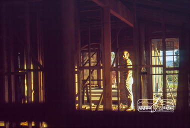
Photograph, Peter Vermey in hall, studs still exposed
14 Stokes Place (Lot 83) was the home of Peter and Carla Vermey. The land was purchased in May 1979 and construction commenced September 1979. The home was built by Peter and Carla Vermey after the developer, Macquarie Builders went bankrupt. Sold October 2017 by Morrison and Kleeman Real Estate. Stokes Place was part of the Stokes Orchard Estate which was developed from the break-up of the the orchard owned by Frank Stokes who lived on the northeast corner of Nyora Road and Eucalyptus Road. His daughter Beryl advised that the Shire had levied a rate assessment on individual parcels of land within the orchard which became unaffordable resulting in its sub-division and sell off. The Stokes Orchard Estate was developed by Macquarie Builders in two stages starting with stage 1 in 1976. Stokes Place was part of Stage 2 in 1979. The Estate was bounded between Nyora Road, Eucalyptus Road, Diosma Road and Stokes Place. The original orchard only just reached the left most portions of Stokes Place and did not go fully up to Diosma, rather to just beyond the extant of Stokes Place. Stokes Place was known within the family as "The Oats" as that is where they grew oats. Frank Stokes moved to Eltham c.1945 after visiting Harold Bird to view his orchard, located diagonally opposite Stokes Orchard from the intersection of Eucalyptus Road, Pitt Street and Nyora Road. It was on Harold Bird's recommendation that Frank purchased the land.The Stokes Orchard Estate collection is typical of housing developments of the late 1970s and 1980s. It was one of the earliest estates in Eltham following the nearby Woodridge Estate development.Digital fileScanned by EDHS from 49 x 35mm colour transparencies provided on loanstokes place, eltham, stokes orchard, stokes orchard estate, streets, houses, peter and carla vermey -
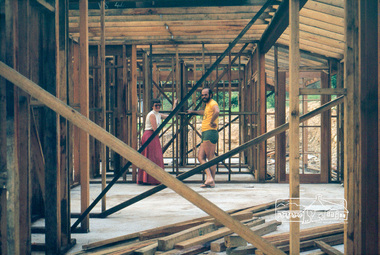 Eltham District Historical Society Inc
Photograph, Peter and Carla Vermey in family area, studs still exposed
14 Stokes Place (Lot 83) was the home of Peter and Carla Vermey. The land was purchased in May 1979 and construction commenced September 1979. The home was built by Peter and Carla Vermey after the developer, Macquarie Builders went bankrupt. Sold October 2017 by Morrison and Kleeman Real Estate. Stokes Place was part of the Stokes Orchard Estate which was developed from the break-up of the the orchard owned by Frank Stokes who lived on the northeast corner of Nyora Road and Eucalyptus Road. His daughter Beryl advised that the Shire had levied a rate assessment on individual parcels of land within the orchard which became unaffordable resulting in its sub-division and sell off. The Stokes Orchard Estate was developed by Macquarie Builders in two stages starting with stage 1 in 1976. Stokes Place was part of Stage 2 in 1979. The Estate was bounded between Nyora Road, Eucalyptus Road, Diosma Road and Stokes Place. The original orchard only just reached the left most portions of Stokes Place and did not go fully up to Diosma, rather to just beyond the extant of Stokes Place. Stokes Place was known within the family as "The Oats" as that is where they grew oats. Frank Stokes moved to Eltham c.1945 after visiting Harold Bird to view his orchard, located diagonally opposite Stokes Orchard from the intersection of Eucalyptus Road, Pitt Street and Nyora Road. It was on Harold Bird's recommendation that Frank purchased the land.The Stokes Orchard Estate collection is typical of housing developments of the late 1970s and 1980s. It was one of the earliest estates in Eltham following the nearby Woodridge Estate development.Digital fileScanned by EDHS from 49 x 35mm colour transparencies provided on loanstokes place, eltham, stokes orchard, stokes orchard estate, streets, houses, peter and carla vermey -
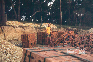 Eltham District Historical Society Inc
Photograph, Peter Vermey in excavation for garage with with stacks of bricks
14 Stokes Place (Lot 83) was the home of Peter and Carla Vermey. The land was purchased in May 1979 and construction commenced September 1979. The home was built by Peter and Carla Vermey after the developer, Macquarie Builders went bankrupt. Sold October 2017 by Morrison and Kleeman Real Estate. Stokes Place was part of the Stokes Orchard Estate which was developed from the break-up of the the orchard owned by Frank Stokes who lived on the northeast corner of Nyora Road and Eucalyptus Road. His daughter Beryl advised that the Shire had levied a rate assessment on individual parcels of land within the orchard which became unaffordable resulting in its sub-division and sell off. The Stokes Orchard Estate was developed by Macquarie Builders in two stages starting with stage 1 in 1976. Stokes Place was part of Stage 2 in 1979. The Estate was bounded between Nyora Road, Eucalyptus Road, Diosma Road and Stokes Place. The original orchard only just reached the left most portions of Stokes Place and did not go fully up to Diosma, rather to just beyond the extant of Stokes Place. Stokes Place was known within the family as "The Oats" as that is where they grew oats. Frank Stokes moved to Eltham c.1945 after visiting Harold Bird to view his orchard, located diagonally opposite Stokes Orchard from the intersection of Eucalyptus Road, Pitt Street and Nyora Road. It was on Harold Bird's recommendation that Frank purchased the land.The Stokes Orchard Estate collection is typical of housing developments of the late 1970s and 1980s. It was one of the earliest estates in Eltham following the nearby Woodridge Estate development.Digital fileScanned by EDHS from 49 x 35mm colour transparencies provided on loanstokes place, eltham, stokes orchard, stokes orchard estate, streets, houses, peter and carla vermey -
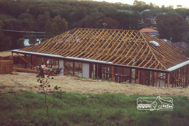 Eltham District Historical Society Inc
Photograph, Carla Vermey in backyard, roof not yet tiled
14 Stokes Place (Lot 83) was the home of Peter and Carla Vermey. The land was purchased in May 1979 and construction commenced September 1979. The home was built by Peter and Carla Vermey after the developer, Macquarie Builders went bankrupt. Sold October 2017 by Morrison and Kleeman Real Estate. Stokes Place was part of the Stokes Orchard Estate which was developed from the break-up of the the orchard owned by Frank Stokes who lived on the northeast corner of Nyora Road and Eucalyptus Road. His daughter Beryl advised that the Shire had levied a rate assessment on individual parcels of land within the orchard which became unaffordable resulting in its sub-division and sell off. The Stokes Orchard Estate was developed by Macquarie Builders in two stages starting with stage 1 in 1976. Stokes Place was part of Stage 2 in 1979. The Estate was bounded between Nyora Road, Eucalyptus Road, Diosma Road and Stokes Place. The original orchard only just reached the left most portions of Stokes Place and did not go fully up to Diosma, rather to just beyond the extant of Stokes Place. Stokes Place was known within the family as "The Oats" as that is where they grew oats. Frank Stokes moved to Eltham c.1945 after visiting Harold Bird to view his orchard, located diagonally opposite Stokes Orchard from the intersection of Eucalyptus Road, Pitt Street and Nyora Road. It was on Harold Bird's recommendation that Frank purchased the land.The Stokes Orchard Estate collection is typical of housing developments of the late 1970s and 1980s. It was one of the earliest estates in Eltham following the nearby Woodridge Estate development.Digital fileScanned by EDHS from 49 x 35mm colour transparencies provided on loanstokes place, eltham, stokes orchard, stokes orchard estate, streets, houses, peter and carla vermey -
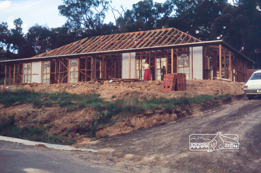 Eltham District Historical Society Inc
Photograph, Carla Vermey on front verandah, framing stage
14 Stokes Place (Lot 83) was the home of Peter and Carla Vermey. The land was purchased in May 1979 and construction commenced September 1979. The home was built by Peter and Carla Vermey after the developer, Macquarie Builders went bankrupt. Sold October 2017 by Morrison and Kleeman Real Estate. Stokes Place was part of the Stokes Orchard Estate which was developed from the break-up of the the orchard owned by Frank Stokes who lived on the northeast corner of Nyora Road and Eucalyptus Road. His daughter Beryl advised that the Shire had levied a rate assessment on individual parcels of land within the orchard which became unaffordable resulting in its sub-division and sell off. The Stokes Orchard Estate was developed by Macquarie Builders in two stages starting with stage 1 in 1976. Stokes Place was part of Stage 2 in 1979. The Estate was bounded between Nyora Road, Eucalyptus Road, Diosma Road and Stokes Place. The original orchard only just reached the left most portions of Stokes Place and did not go fully up to Diosma, rather to just beyond the extant of Stokes Place. Stokes Place was known within the family as "The Oats" as that is where they grew oats. Frank Stokes moved to Eltham c.1945 after visiting Harold Bird to view his orchard, located diagonally opposite Stokes Orchard from the intersection of Eucalyptus Road, Pitt Street and Nyora Road. It was on Harold Bird's recommendation that Frank purchased the land.The Stokes Orchard Estate collection is typical of housing developments of the late 1970s and 1980s. It was one of the earliest estates in Eltham following the nearby Woodridge Estate development.Digital fileScanned by EDHS from 49 x 35mm colour transparencies provided on loanstokes place, eltham, stokes orchard, stokes orchard estate, streets, houses, peter and carla vermey -
 Eltham District Historical Society Inc
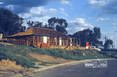
Photograph, House from front, framing stage
14 Stokes Place (Lot 83) was the home of Peter and Carla Vermey. The land was purchased in May 1979 and construction commenced September 1979. The home was built by Peter and Carla Vermey after the developer, Macquarie Builders went bankrupt. Sold October 2017 by Morrison and Kleeman Real Estate. Stokes Place was part of the Stokes Orchard Estate which was developed from the break-up of the the orchard owned by Frank Stokes who lived on the northeast corner of Nyora Road and Eucalyptus Road. His daughter Beryl advised that the Shire had levied a rate assessment on individual parcels of land within the orchard which became unaffordable resulting in its sub-division and sell off. The Stokes Orchard Estate was developed by Macquarie Builders in two stages starting with stage 1 in 1976. Stokes Place was part of Stage 2 in 1979. The Estate was bounded between Nyora Road, Eucalyptus Road, Diosma Road and Stokes Place. The original orchard only just reached the left most portions of Stokes Place and did not go fully up to Diosma, rather to just beyond the extant of Stokes Place. Stokes Place was known within the family as "The Oats" as that is where they grew oats. Frank Stokes moved to Eltham c.1945 after visiting Harold Bird to view his orchard, located diagonally opposite Stokes Orchard from the intersection of Eucalyptus Road, Pitt Street and Nyora Road. It was on Harold Bird's recommendation that Frank purchased the land.The Stokes Orchard Estate collection is typical of housing developments of the late 1970s and 1980s. It was one of the earliest estates in Eltham following the nearby Woodridge Estate development.Digital fileScanned by EDHS from 49 x 35mm colour transparencies provided on loanstokes place, eltham, stokes orchard, stokes orchard estate, streets, houses, peter and carla vermey