Showing 1548 items matching " aerial photographs"
-
 Eltham District Historical Society Inc
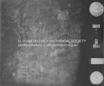
Photograph - Aerial Photograph, Eltham East, Main Road, Zig Zag Rd, 13 Jan. 1968
... Aerial Photograph... Photograph Aerial Photograph ...shire of eltham archives, aerial photo, main road, eltham east, zig zag road -
 Eltham District Historical Society Inc
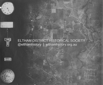
Photograph - Aerial Photograph, St Andrews North, Ninks Rd, and main Heidelberg - Kinglake Road, 13 Jan. 1968
... Aerial Photograph... Heidelberg - Kinglake Road Photograph Aerial Photograph ...Two future house sites marked with blue crossesshire of eltham archives, aerial photo, heidelberg-kinglake road, ninks road, st andrews -
 Eltham District Historical Society Inc
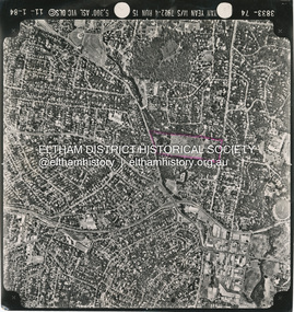
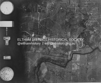
Photograph - Aerial Photograph, Montmorency to Eltham North, 11 Jan. 1984
... Aerial Photograph... to Eltham North Photograph Aerial Photograph ...Area highlighted in purple is the future Nerreman Gateway Estate spanning from Ryans Road to Karingal Driveshire of eltham archives, aerial photo, eltham north, montmorency, nerreman gateway, nerreman park estate, ryans road, karingal drive -
 Eltham District Historical Society Inc
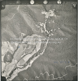
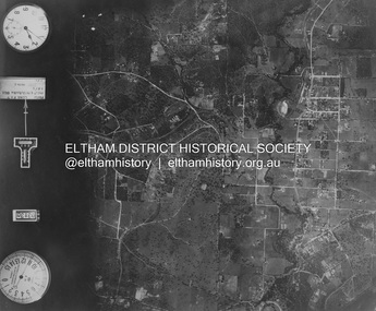
Photograph - Aerial Photograph, Smiths Gully, Christmas Hills, St Andrews, Kinglake National Park, 6 Mar. 1986
... Aerial Photograph... National Park Photograph Aerial Photograph ...Small scale Red arrow indicates Northshire of eltham archives, aerial photo, christmas hills, kinglake national park, smiths gully, st andrews -
 Eltham District Historical Society Inc
Photograph - Aerial Photograph, Landata, Eltham, Main Road; Henry St to Bellevue Rd, Dec. 1945
... Aerial Photograph...; Henry St to Bellevue Rd Photograph Aerial Photograph Landata ...Eltham, Main Road; Henry St to Bellevue Rd, and east along Luck St to present day Eltham East School Historic Aerial Imagery Source: Landata.vic.gov.au Aerial Photo Details: Project No :5 Project : MELBOURNE AND METROPOLITAN AREA PROJECT Run : 36 Frame : 60549 Date : 12/1945 Film Type : B/W Camera : EAG4 Flying Height : 10200 Scale : 6000 Film Number : 228 GDA2020 : 37°42'45"S, 145°08'59"E MGA2020 : 336903, 5824465 (55) Melways : 21 K4 (ed. 42)aerial photo, arthur street, bellevue road, bible street, diamond street, dudley street, elsa court, eltham, eltham east primary school, gahan house, henry street, livingstone road, luck street, main road, pryor street, neil webster collection -
 Eltham District Historical Society Inc
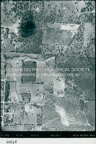
Photograph - Aerial Photograph, Landata, Eltham, Luck St; Bible St to Beard St, Dec. 1945
... Aerial Photograph...; Bible St to Beard St Photograph Aerial Photograph Landata ...Centred on present day Eltham East Primary School, east of Main Rd along Luck St to Beard St Historic Aerial Imagery Source: Landata.vic.gov.au Aerial Photo Details: Project No :5 Project : MELBOURNE AND METROPOLITAN AREA PROJECT Run : 36 Frame : 60548 Date : 12/1945 Film Type : B/W Camera : EAG4 Flying Height : 10200 Scale : 6000 Film Number : 195 GDA2020 : 37°42'46"S, 145°09'18"E MGA2020 : 337371, 5824456 (55) Melways : 22 A4 (ed. 42)aerial photo, eltham, arthur street, beard street, bible street, eltham east primary school, frank street, henry street, luck street, stanley avenue, wycliffe crescent, neil webster collection -
 Eltham District Historical Society Inc
Photograph - Aerial Photograph, Landata, Eltham, Main Rd; Railway Rd to Zig Zag Rd, Dec. 1945
... Aerial Photograph... Eltham, Main Rd; Railway Rd to Zig Zag Rd Photograph Aerial ...Centred on present day Edendale Farm from Glen Park rd to Zig Zag Rd Historic Aerial Imagery Source: Landata.vic.gov.au Aerial Photo Details: Project No :5 Project : MELBOURNE AND METROPOLITAN AREA PROJECT Run : 37 Frame : 60549 Date : 12/1945 Film Type : B/W Camera : EAG4 Flying Height : 10200 Scale : 6000 Film Number : 196 GDA2020 : 37°42'12"S, 145°09'09"E MGA2020 : 337141, 5825486 (55) Melways : 21 K2 (ed. 42)aerial photo, eltham, edendale farm, eltham - yarra glen road, eltham-hurstbridge railway line, gastons homestead, gastons road, glen park road, main road, park road, railway road, wattletree road, zig zag road, neil webster collection -
 Eltham District Historical Society Inc
Photograph - Aerial Photograph, Landata, Eltham, Main Road; Mt Pleasant Rd to Railway Rd, Dec. 1945
... Aerial Photograph... Road; Mt Pleasant Rd to Railway Rd Photograph Aerial Photograph ...Centred on Main Rd and Henry St, Eltham bounded by Railway Road to north, Mount Pleasant Road at Main Road to south, top of the hill in Arthur Street to east and Karingal Drive at Sherbourne Road to west. Historic Aerial Imagery Source: Landata.vic.gov.au Aerial Photo Details: Project No :65 Project : MELBOURNE AND METROPOLITAN PROJECT NO. 2 Run : 8 Frame : 70 Date : 01/1951 Film Type : B/W Camera : EAG9 Flying Height : 12200 Scale : 12000 Film Number : 1419 GDA2020 : 37°43'06"S, 145°08'45"E MGA2020 : 336589, 5823811 (55) Melways : 21 J6 (ed. 42)aerial photo, eltham, main road, henry street, arthur street, bolton street, eltham-yarra glen road, neil webster collection, 1951-01, dave lyon house, ernie andrew house, karingal road, melway 21j6, mount pleasant road, railway road -
 Eltham District Historical Society Inc
Photograph - Aerial Photograph, Landata, Eltham and Lower Plenty, Nov. 1931
... Aerial Photograph... Aerial Photograph Landata ...Centred over present-day Rosehill Road and View Road, Lower Plenty Historic Aerial Imagery Source: Landata.vic.gov.au Aerial Photo Details: Project No :1931 Project : MALDON PRISON Run : 19 Frame : 3129 Date : 11/1931 Film Type : B/W Camera : F8 Flying Height : 11000 Scale : 18860 Film Number : 60 GDA2020 : 37°44'16"S, 145°07'40"E MGA2020 : 335039, 5821622 (55) Melways : 21 E11 (ed. 42)aerial photo, eltham, lower plenty, neil webster collection, rosehill road, view road -
 Eltham District Historical Society Inc
Photograph - Aerial Photograph, Landata, Eltham and Montmorency, Nov. 1931
... Aerial Photograph... and electronic PDF file Eltham and Montmorency Photograph Aerial ...Centred over present-day Belmont Reserve, Montmorency Historic Aerial Imagery Source: Landata.vic.gov.au Aerial Photo Details: Project No :1931 Project : MALDON PRISON Run : 19 Frame : 3130 Date : 11/1931 Film Type : B/W Camera : F8 Flying Height : 11000 Scale : 18860 Film Number : 60 GDA2020 : 37°43'13"S, 145°07'54"E MGA2020 : 335330, 5823576 (55) Melways : 21 F6 (ed. 42)aerial photo, eltham, neil webster collection, belmont reserve, montmorency, rattray road -
 Eltham District Historical Society Inc
Photograph - Aerial Photograph, Landata, Eltham and Eltham North, Nov. 1931
... Aerial Photograph... Aerial Photograph Landata ...Centred over present-day Opal Court and Manning Road, Eltham North Historic Aerial Imagery Source: Landata.vic.gov.au Aerial Photo Details: Project No :1931 Project : MALDON PRISON Run : 19 Frame : 3131 Date : 11/1931 Film Type : B/W Camera : F8 Flying Height : 11000 Scale : 18860 Film Number : 60 GDA2020 : 37°42'10"S, 145°08'07"E MGA2020 : 335621, 5825531 (55) Melways : 21 G2 (ed. 42)aerial photo, eltham, neil webster collection, eltham north, manning road, opal court -
 Eltham District Historical Society Inc
Photograph - Aerial Photograph, Landata, Eltham and Eltham East, Nov. 1931
... Aerial Photograph... Photograph Aerial Photograph Landata ...Centred over present-day Beard Street bewteen Park Road and Main Road, Eltham East Historic Aerial Imagery Source: Landata.vic.gov.au Aerial Photo Details: Project No :1931 Project : MALDON PRISON Run : 20 Frame : 3135 Date : 11/1931 Film Type : B/W Camera : F8 Flying Height : 11000 Scale : 18860 Film Number : 60 GDA2020 : 37°42'16"S, 145°09'41"E MGA2020 : 337912, 5825386 (55) Melways : 22 B2 (ed. 42)aerial photo, eltham, neil webster collection, beard street, eltham east, main road, park road -
 Eltham District Historical Society Inc
Photograph - Aerial Photograph, Landata, Eltham, Nov. 1931
... Aerial Photograph... Digital tif and electronic PDF file Eltham Photograph Aerial ...Centred over present-day Laleham Court between Arthur Street and Hartland Way, Eltham Historic Aerial Imagery Source: Landata.vic.gov.au Aerial Photo Details: Project No :1931 Project : MALDON PRISON Run : 20 Frame : 3136 Date : 11/1931 Film Type : B/W Camera : F8 Flying Height : 11000 Scale : 18860 Film Number : 60 GDA2020 : 37°42'56"S, 145°09'33"E MGA2020 : 337759, 5824139 (55) Melways : 22 B5 (ed. 42) aerial photo, eltham, neil webster collection, arthur street, hartland way, laleham court -
 Eltham District Historical Society Inc
Photograph - Aerial Photograph, Landata, Eltham, Nov. 1931
... Aerial Photograph... tif and electronic PDF file Eltham Photograph Aerial ...Centred over Mount Pleasant Road and Kent Hughes Road, Eltham Historic Aerial Imagery Source: Landata.vic.gov.au Aerial Photo Details: Project No :1931 Project : MALDON PRISON Run : 20 Frame : 3137 Date : 11/1931 Film Type : B/W Camera : F8 Flying Height : 11000 Scale : 18860 Film Number : 60 GDA2020 : 37°43'37"S, 145°09'26"E MGA2020 : 337606, 5822892 (55) Melways : 22 A8 (ed. 42) aerial photo, eltham, neil webster collection, kent hughes road, mount pleasant road -
 Eltham District Historical Society Inc
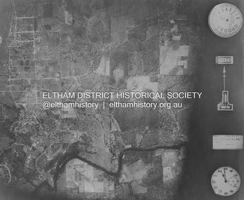
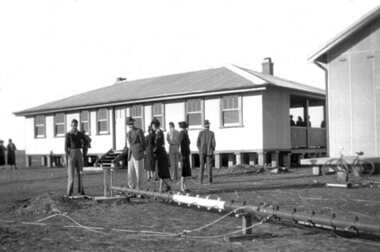
Document - Series Listing, Fraser Faithfull et al, Series 48: Aerial Views of Shire & Newly Completed Library, May 1994, 23 colour photographs, 2000
Series consists of colour prints measuring from 215mm x 150mm up to 255mm x 200mm. Includes views of Sugarloaf Reservoir, Petty's Orchard, Residential Areas, Shire Offices and New Library.shire of eltham archives, series listing -
 Eltham District Historical Society Inc
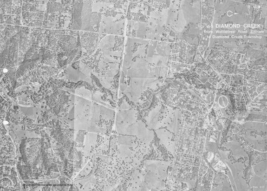
Work on paper (Sub-Item) - Photograph, Diamond Creek from Wattletree Road, Eltham to Diamond Creek township
Black and white aerial view of Diamond Creek from Wattletree Road, Eltham to Diamond Creek Townshipeltham, drain, diamond creek -
 Lara RSL Sub Branch
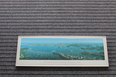
Framed Print of Naval Review,Sydney Harbour, 1st October,1988, Naval Review,Sydney Harbour, 1st October,1988, 12/01/1990
The bicentenary of Australia was celebrated in 1988. It marked 200 years since the arrival of the First Fleet of British convict ships at Sydney in 1788. This aerial photo shows naval and pleasure craft in Sydney Harbour for the bicentennial celebrations.The bicentennial year marked Captain Arthur Phillip's arrival with the 11 ships of the First Fleet in Sydney Harbour in 1788, and the founding of the city of Sydney and the colony of New South Wales. 1988 is considered the official bicentenary year of the founding of Australia. Rectangular shaped glass covered picture frame showing photo of Naval Review, Sydney Harbour, 1st October,1988Naval Review, Sydney Harbour, 1st October,1988 This 140 degree panoramic photograph was taken from a helicopter by Phil Gray. It shows the visiting warships in the harbour including the USS New Jersey, FNS Colbert and HMS Ark Royal in the foreground.This print is the fourth in the Sydney Harbour Panorama series by Phil Gray who uses Kodak film.Printed in Australia.prints, naval photos, hms ships, sydney harbour, lara r.s.l. -
 Nhill Aviation Heritage Centre
Black and white photograph, Local photograph. Original of this scan held by Nhill Historical Society, Aeradio Building c1937
This building is still intact at the Nhill Aerodrome. Some of the infrastructure is also in place or can be evidenced by its foundations.The Aeradio building was built on the present aerodrome in 1937. This was one of only sixteen buildings of this type built across Australia and it housed radio communications and guidance equipment. The building and its equipment were part of a comprehensive system of radio towers, signalling and meteorology equipment aimed at providing safer navigation for aircraft travelling throughout Australia. The facility closed in the 1960sThis photo is significant due to it having been taken soon after the building was constructed. It is the earliest known photograph taken on an open to the public day before the receiver aerials were erected.The Aeradio building was built on the present (2012) aerodrome in 1937 or 1938. This was one of only fifteen buildings of this type built across Australia and it housed radio communications and guidance equipment. The building and its equipment were part of a comprehensive system of radio towers lights and signalling equipment aimed at providing safer navigation for aircraft travelling throughout Australia. The facility closed in the 1960sphoto, aeradio, early, civil aviation, dca, dept of civil aviation -
 Bendigo Military Museum
Photograph - Air Survey Squadron - Army Survey Regiment, Bendigo, c1988
This is a photograph of Air Survey Squadron, one of the Army Survey Regiment’s four squadrons, taken at Fortuna, Bendigo, c1988. Air Survey Squadron’s main functions were aerotriangulation and digital photogrammetric extraction of 3D topographic features from aerial photography, using Wild B8s coupled to the AUTOMAP 2 computer system.This is a photograph of Air Survey Squadron at the Army Survey Regiment, Fortuna, Bendigo, c1988. The photograph was printed on photographic paper and is part of the Army Survey Regiment’s Collection. The photograph was scanned at 300 dpi. .1) - Photo, black & white, c1988: Back Row L to R: SPR Mark Linwood, SPR Trevor Roddam, SPR Noel Brinsmead, CPL Mark Lander, CPL Frank Downie, SPR Sandy Craig 3th Row L to R: SPR Steve Rundle, unidentified, Darren Wilkinson, CPL Dave Longbottom, SPR Max Watson, unidentified, SGT Paul Hopes, unidentified. 2nd Row L to R: SGT John ‘Shep’ Shepherd, SPR Paul Boulton, SPR Stuart Bowd, SPR Paula (Golding) Brinsmead, SPR Jo Otto, CPL Steve Coulson, SPR Steve Linane, CPL Chris ‘Charlie’ Brown. Front Row L to R: SSGT Bruce ‘Hap’ Hammond, WO2 Barry Lutwyche, LT Struan Robinson, SSM WO1 Alan Hancox, OC MAJ Peter Clark, LT Simon Buckpitt, WO2 Neil ‘Ned’ Kelly, SSGT Noel ‘Macca’ McNamara.No personnel are identifiedroyal australian survey corps, rasvy, army survey regiment, army svy regt, fortuna, asr, air survey -
 Bendigo Military Museum
Photograph - Photo Troop, Lithographic Squadron - Army Survey Regiment, Bendigo, 1989
This is a photograph of Photo Troop, Lithographic Squadron; one of the Army Survey Regiment’s four squadrons, at Fortuna, Bendigo, December 1989. The main tasks undertaken by Photo Troop’s technicians were most likely photographic enlargements, reductions and duplication of map reproduction material, and processing of aerial photography.This is a photograph of Photo Troop Lithographic Squadron, Army Survey Regiment at Fortuna, Bendigo, 1989. The colour photograph was printed on photographic paper and is part of the Army Survey Regiment’s Collection. The photograph was scanned at 300 dpi. Back Row L to R: Rob Bogumil, Kevin ‘Chuck’ Berry, Andrew ‘Morrie’ Morrison-Evans, unidentified, Greg Howell, unidentified, Damien Cole, unidentified, Warren ‘Waldo’ Shirley, Steve Burke, Paul Baker, Bob Garritty, Frank Lenane, Bill Jones. Front Row L to R: John Bragg, Ken Peters, Gavin Craggs, Michelle Withers, Penny Knott, Di Chalmers, Geoff Webb, unidentified, Darren ‘Barney’ Maher, Kim Reynolds. No personnel are identified. Annotated on back with ‘Photo Troop Dec 1989’royal australian survey corps, rasvy, army survey regiment, army svy regt, fortuna, asr, litho -
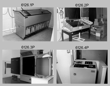
 Bendigo Military Museum
photograph - Orthorectification Equipment - Army Survey Regiment, Fortuna, Bendigo, c1975
Orthophoto mapping provided the Survey Corps with the capability to produce map products quickly in the event of a crisis. These are four photographs of equipment used by the Army Survey Regiment to produce orthophotomaps. The Wild GZ1 orthophoto projector was introduced in 1973 and was the first equipment used to orthorectify colour and monochrome film aerial photography. Height profiles were originally produced on a PEB8 Stereo profiler and later were software generated. Photos of the PEB8 are available in Victorian Collections item 6222.17P, photos .5P and .6P. In the same era the IBM 1130 computer; OMI/Nistri AP/C-3 analytical plotter with coordinatograph, OP/C orthophoto projector and Zeiss Planimat D2 stereoplotters were introduced. Orthorectification is the process of removing geometric distortions and scale errors/variations from images. Images have tilt and relief distortions that make it difficult to compare accurately a map and an image of the same geographic area. Once an image is orthorectified, features on the image are shown in their planimetric locations. These four photographs of orthorectification equipment were taken at the Army Survey Regiment at Fortuna, Bendigo, c1975. Photo .1P and .3P were printed on photographic paper and scanned at 300 dpi. Photos .2P, .4P and .5P were on 35mm negative film and scanned at 96 dpi. They are part of the Army Survey Regiment’s Collection. .1) - Photo, black & white, c1975, Wild GZ1 orthophoto projector operated by CPL Phil Boyle. .2) - Photo, black & white, c1975, Wild GZ1 orthophoto projector. .3) - Photo, black & white, c1975, Wild GZ1 orthophoto projector. .4) - Photo, black & white, c1978, Zeiss D2 Planimat Stereoplotter. .5) - Photo, black & white, c1978, Zeiss D2 Planimat Stereoplotter..1P to .5P No annotations.royal australian survey corps, rasvy, army survey regiment, army svy regt, fortuna, asr -
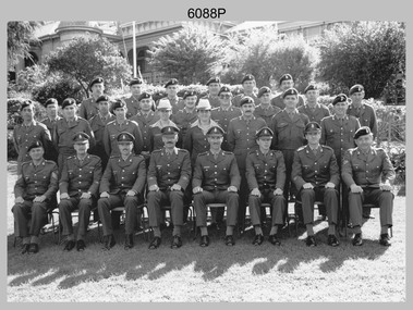
 Bendigo Military Museum
Photograph - Army Survey Regiment’s Officers, Warrant Officers and Sergeants and Squadrons, at Fortuna, Bendigo, 1982
This is a set of six staff photographs of the Army Survey Regiment’s Officers, Warrant Officers and Sergeants, and each of its four Squadrons at Fortuna, Bendigo in December 1982. Note - Air Survey Squadron’s photo was probably taken in July 1982 as they appear in winter dress. Air Survey Squadron was responsible for aerotriangulation, photogrammetric feature extraction and the AUTOMAP 1 system. Typical tasks were flight planning the acquisition of aerial photography, pugging, mensuration and block adjustments, photogrammetric extraction of topographic features from aerial photography, digital feature editing, map compilation, operating the scanner/plotter, operating the AUTOMAP 1 system and computer programming by civilians. Cartographic Squadron was responsible for the production of the following military products: Joint Operation Graphics, small-scale RAAF Air Charts, large-scale topographic line maps and orthophotomaps. Cartographic technician tasks were scribing, compiling, retouching, masking, type setting, type stickup, terrain embossing, correcting and proving quality control. Headquarters Squadron was responsible for the planning and coordination of map production and contracts. It also performed administrative and support functions such as personnel administration, pay, finance, transportation, records, map Library, kitchens, messes and facility maintenance. It was staffed by Army personnel from RASvy, RACT, AACC, RAAOC and RAEME corps. Other supporting staff at this time included the RAAF Liaison Officer, RAN Liaison Officer and several civilians employed in administration, the Q-Store and grounds maintenance. A component of the Army Svy Regt’s cartographic map production was carried out by the Detachment, a sub-unit located at Bonegilla next to the School of Military Survey. Lithographic Squadron was responsible for the reproduction of map materials and printing of military map products. The main tasks undertaken by photographic technicians were photographic enlargements, reductions and duplication of map reproduction material and processing of aerial photography. Printing technician tasks included platemaking, offset printing, map stock despatching and proofing.This is a set of six staff photographs of the Army Survey Regiment’s Officers, Warrant Officers and Sergeants, and its four Squadrons, at Fortuna, Bendigo, 1982. The black and white photographs were printed on photographic paper and are part of the Army Survey Regiment’s Collection. The photograph was scanned at 300 dpi. No personnel are identified. No personnel are identified. .1P – Annotated on front “OFFICERS MESS DEC ’82” .2P – Annotated on back “SGTS MESS DEC ’82” .4P– Annotated on front “CARTO SQN DEC ’82” .5P– Annotated on front “HQ SQN DEC ’82”royal australian survey corps, rasvy, army survey regiment, army svy regt, fortuna, asr, air survey, carto, litho -
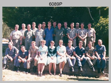
 Bendigo Military Museum
Photograph - Photo Troop, Lithographic Squadron – Army Survey Regiment, Fortuna, Bendigo, 1986
This collection of 18 photos was most likely taken at Lithographic Squadron, Army Survey Regiment, Fortuna, Bendigo in 1986. The main tasks undertaken by technicians in Photo Troop were most likely enlargements, reductions and duplication of map reproduction material, and processing of aerial photography.This is a set of 18 photographs of Photo Troop personnel and equipment from Lithographic Squadron at the Army Survey Regiment, Fortuna, Bendigo, 1986. The photographs were on 35mm negative film and were scanned at 96 dpi. They are part of the Army Survey Regiment’s Collection. .1) - Photo, black & white, 1986, Film developer. .2) - Photo, black & white, 1986, Chromalin Proof equipment. .3) - Photo, black & white, 1986, KLIMSCH Commodore camera. .4) - Photo, black & white, 1986, KLIMSCH Commodore camera operator’s console. .5) - Photo, black & white, 1986, Film contact frame. .6) - Photo, black & white, 1986, Film processing chemicals. .7) - Photo, black & white, 1986, Unidentified technician. .8) - Photo, black & white, 1986, L to R: Unidentified technician, SPR Russell Pajank, SPR Carmel (Butler) Fauth. .9) - Photo, black & white, 1986, SPR Carmel (Butler) Fauth. .10) - Photo, black & white, 1986, SPR Carmel (Butler) Fauth. .11) - Photo, black & white, 1986, L to R: CPL Paul Baker, SGT Rob Bougumil. .12) - Photo, black & white, 1986, CPL Paul Baker. .13) - Photo, black & white, 1986, CPL Paul Baker. .14) - Photo, black & white, 1986, L to R: CPL Paul Baker, CPL Brian Paul. .15) - Photo, black & white, 1986, L to R: CPL Frank Lenane, SGT Rob Bougumil. .16) - Photo, black & white, 1986, CPL Brian Fauth. .17) - Photo, black & white, 1986, WO1 Trevor Osborne. .18) - Photo, black & white, 1986, L to R: SPR Kerron South, SGT Rob Bogumil.No personnel are identifiedroyal australian survey corps, rasvy, army survey regiment, army svy regt, fortuna, asr, litho -
 Bendigo Military Museum
Photograph - Records Hut Personnel – Army Survey Regiment, Fortuna, Bendigo, c1986
These four photos of RaSVY personnel were taken inside the Records Hut, one of Headquarters Squadron’s work areas at the Army Survey Regiment, Fortuna probably in 1986. This building was located near the basketball court and probably at that time, held aerial photography archives, flight planning records, production data folders and final colour separated negatives of published maps.This is a set of two photographs of Records Hut personnel from Headquarters Squadron, Army Survey Regiment, Fortuna, Bendigo, 1986. The photographs were on 35mm negative film and were scanned at 96 dpi. They are part of the Army Survey Regiment’s Collection. .1) - Photo, black & white, 1986, Records Hut – SPR Brett Treneman. .2) - Photo, black & white, 1986, Records Hut – LCPL Bob Sheppard. .3) - Photo, black & white, 1986, Records Hut – L to R: LCPL Bob Sheppard, SPR Brett Treneman. .4) - Photo, black & white, 1986, Records Hut – L to R: LCPL Bob Sheppard, SPR Brett Treneman.No personnel are identifiedroyal australian survey corps, rasvy, army survey regiment, army svy regt, fortuna, asr -
 Bendigo Military Museum
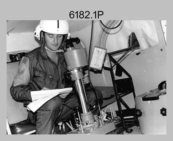
Photograph - Royal Australian Survey Corps Aerial Surveys, c1980
... . Royal Australian Survey Corps Aerial Surveys Photograph Royal ...This is a set of nine photographs of technicians from the Royal Australian Survey Corps operating aerial surveys equipment c1980s. In photo .1P, CPL Steve Gloster was operating a RC10 air survey camera mounted in an Australian Army Pilatus Porter aircraft. The Wild RC10 super wide-angle air survey cameras were first introduced in 1971, were equipped with virtual distortion free lenses for supplementary, spot and special photography. In photo .2P, Roger Rees was operating Air Profile Recorder (APR) equipment. it was possibly taken during OP NERVOSE 84, sometime between June – August 1984 when based in Ngukurr, Northern Territory. The APR was operated at this time in unison with an RC10 camera. In 1963 the Royal Australian Survey Corps introduced the radar airborne profile recorder (Canadian Applied Research Ltd, Mark V, Airborne Profiler Recorder) was introduced for 1:100,000 mapping to replace terrain heighting by aneroid barometry. Later in 1974-1975, the Australian developed WREMAPS II airborne laser terrain profile recorder was introduced. In photo .3P, Neil Jones appears at the door of Airsearch Beechcraft Queen Air aircraft, Registration / Serial VH-MWX. This aircraft was typically used by RA Svy on air survey operations flying mission with Aerodist, APR and RC10 camera equipment. The Australian Army’s Pilatus Porter (short take-off and landing turbo propeller) was also equipped with a Wild RC10 aerial mapping camera for identification photography. The Pilatus Porter was also used on RA Svy’s map field checking operations. Photo .9P was taken at a survey station at an unknown location. In this photo an Australian Army Kiowa Light Observation Helicopter (LOH) is supporting a field survey party undertaking Magnavox AN/PRR-14 portable Doppler satellite observations. The satellite receiver’s antenna is plumbed over the survey ground mark surrounded by white plastic panels. The panels were used to identify the survey station on aerial photography. Introduced in 1974–1975, the Magnavox AN/PRR-14 portable Doppler satellite (US Navy Navigation Satellite System – TRANSIT) receivers and computing system provided independent three-dimensional point positions anywhere in the world, anytime, in any weather accurate to about 1.5metres with precise satellite ephemerides. The Bell OH-58 Kiowa LOH was a family of military helicopters used for observation, utility, and direct fire support. It was identified by RA Svy in the mid-1970s that considerable time was lost in replacing unserviceable remote equipment by road. Therefore Aerodist operations (pre-dating satellite receiver operations) were fully supported by Army’s Kiowa LOH aircraft. This is a set of nine photographs of technicians from the Royal Australian Survey Corps operating aerial surveys equipment c1980s. .1P to .3P, .5P to .9P - Colour and black and white photos on photographic paper and scanned at 300 dpi. .4P - Colour photo on 35mm slide film and scanned at 96 dpi. .1) & .2) - Photo, black & white, c1980s, CPL Steve Gloster operating an RC10 air camera. .3) - Photo, colour, 1984, Roger Rees operating Air Profile Recorder (APR) equipment. .4) - Photo, colour, c1980s, Neil Jones at the door of an Airsearch Beechcraft Queen Air aircraft, typically used by RA Svy on air survey operations. .5) - Photo, colour, c1980s. A Beechcraft King Air aircraft, also used by RA Svy on air survey operations. .6) - Photo, colour, c1980s. An Australian Army Pilatus Porter, used by RA Svy on air survey and map field checking operations. SGT Peter Mustart is possibly in the foreground. .7) to .8) - Photo, colour, c1980s. An Australian Army Pilatus Porter and unidentified personnel, used by RA Svy on air survey and map field checking operations. .9) - Photo, colour, c1980s. An Australian Army Kiowa helicopter supporting a field survey party undertaking Magnavox AN/PRR-14 portable Doppler satellite observations. There are biro marks on photos .4P to .9Proyal australian survey corps, rasvy, army survey regiment, asr, fortuna, aerial surveys -
 Bendigo Military Museum
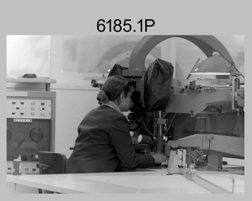
Photograph - Capturing Topographic Features with a Wild B8 – Army Survey Regiment, Fortuna, Bendigo, c1980
These four photographs of SPR Santina (Argetto) Straube capturing topographic features – plotting with a Wild B8 stereo plotter were most likely taken in c1980. Introduced in 1966, the Wild B8 stereo plotter was used for plotting topographic detail and contours. These analogue machines were manually controlled by adjusting the control knobs for the orientation of the 3D image. The B8s used a nine-inch square photo image on a film or glass diapositive which allowed highly accurate extraction of map features. At first, plotting by B8 and B9 equipment was undertaken at the aerial photography scale of 1:80,000 in pencil onto a controlled plotting sheet. Sheets were then inked up and reduced photographically to the 1: 100,000 publication scale for scribe impression production. In these photos SPR Santina (Argetto) Straube was plotting with a pencil or ink pen mounted at the far end of the pantograph arm. The plotting procedure was upgraded to direct plotting in ink with photographic reduction to publication scale. In 1975 four B8s were upgraded with tri-axis locaters as part of the Input Sub-system to enable digital extraction to AUTOMAP 1’s topographic database. When AUTOMAP 2 was introduced in 1982 these B8s were upgraded, and additional machines added to expand the Army Survey Regiment’s digital capture capability. This is a set of four photographs of a technician capturing topographic Features with a Wild B8 stereo plotter in Air Survey Squadron – Army Survey Regiment, Fortuna, Bendigo. 1980. The photographs were on 35mm negative film and were scanned at 96 dpi. They are part of the Army Survey Regiment’s Collection. .1) to .4) Photo, black & white, c1980. SPR Santina (Argetto) Straube operating a Wild B8 stereo plotter..1P to .4P – no annotations.royal australian survey corps, rasvy, army survey regiment, army svy regt, fortuna, asr, air survey, photogrammetry -
 Bendigo Military Museum
Photograph - Multiplex mechanical stereoplotting equipment, Army Survey Regiment, Fortuna Bendigo, c1950s
This is a set of five photographs of Multiplex mechanical stereoplotting equipment at the Army Survey Regiment, Fortuna Bendigo. c1950s. Multiplex equipment was imported from the UK in 1951 and introduced in the following year, to accelerate map production output covering CMF training areas at 1:25,000 map scale. Multiplex plotting was a productive advancement replacing the ‘Arundel’ method of graphical plotting planimetric detail that was expensive and slow, especially in timbered mountainous terrain. Air photos were made into small diapositives and mounted on racks in the exact position relative to when the aerial photos were taken. The technicians operated the Multiplex in a darkened room, with one photo projected with a green filter and the other through a red filter to form a 3D view of the overlapping photos. The 3D model projected onto a platen, which was a small platform that was raised up and down. The technician viewed the 3D image with special glasses fitted with red and green lenses. In the centre of the platen was a small pinhole that served as a floating mark, with a vertical pencil located exactly below the pinhole. This tracing table was moved to follow the topographic feature or contour line and draw it on the paper underneath. The technician raising or lowering the platform’s floating mark to match the height of the 3D terrain. It also replaced the slotted template method of mechanical adjustment of strips of aerial photography, however was restricted to each strip rather than between strips in the block. Although the Multiplex was phased out of production in 1968, it was used in the training of photogrammetry and aero-triangulation at the School of Military Survey located at Bonegilla, Victoria until the early 1990s. The history of the Multiplex is covered in more detail with additional historic photographs, in pages 50 to 51 of Valerie Lovejoy’s book 'Mapmakers of Fortuna – A history of the Army Survey Regiment’ ISBN: 0-646-42120-4.This is a set of five photographs of Multiplex mechanical stereoplotting equipment at the Army Survey Regiment, Fortuna, Bendigo. c1950s. The photographs were printed on photographic paper and are part of the Army Survey Regiment’s Collection. The photographs were scanned at 300 dpi. .1) - Photo, black & white, c1950s, unidentified personnel operating Multiplex equipment. .2) - Photo, black & white, c1950s, Multiplex equipment. .3) - Photo, black & white, c1950s, Multiplex components identified. .4) - Photo, black & white, c1950s, Multiplex optical components. .5) - Photo, black & white, c1950s. Unidentified technician laying down individual Multiplex plots..1P to .2P, .4P – No annotations. .3P annotations identifying Multiplex components on front of photo. .5P annotated on front ‘Lay down of individual Multiplex plots at 1/14000 to framework of master grid to form Composite Compilation Sheet – Material Duralex.’royal australian survey corps, rasvy, army survey regiment, army svy regt, fortuna, asr, photogrammetry -
 Bendigo Military Museum
Photograph - Photographic Technicians performing tasks at the Army Survey Regiment, c1970s
These eleven photographs were most likely taken in the 1970s in Lithographic Squadron at the Army Survey Regiment, Fortuna, Bendigo. Although Photo .1P is not annotated the remainder have the technician’s name written on the back. The equipment operated by the technicians is not identified. The dates are unknown but most of these photos were probably taken the late 1970s. The main tasks undertaken by the technicians were most likely enlargements, reductions and duplication of map reproduction material, and aerial photography.This is a set of photographs of technicians operating photographic reproduction equipment at the Army Survey Regiment, Bendigo c1970s. The photographs were printed on photographic paper and are part of the Army Survey Regiment’s Collection. The photographs were scanned at 300 dpi. .1) - Photo, black & white, c1970s, unidentified, Lithographic Squadron .2) - Photo, black & white, c1970s, Gary Drummond, Lithographic Squadron .3) - Photo, black & white, c1970s, John Scott, Lithographic Squadron .4) - Photo, black & white, c1970s, WILD U4A Diapositive Camera, Bob Chamberlain, Lithographic Squadron. 5) - Photo, black & white, c1970s, WILD U4A Diapositive Camera, Zoe (Lisiewich) Ames, Lithographic Squadron .6) - Photo, black & white, c1970s, Garry Hudson, Lithographic Squadron .7) - Photo, black & white, c1970s, Garry Hudson, Lithographic Squadron .8) - Photo, black & white, c1970s, Garry Hudson, Lithographic Squadron .9) - Photo, black & white, c1970s, Mick Ellis, Lithographic Squadron .10) - Photo, black & white, c1970s, Col Darch, Lithographic Squadron .11) - Photo, black & white, c1970s, Phil Beatty, Lithographic Squadron.1P – no annotation .2 to .11 – personnel names (less rank) annotated on back. royal australian survey corps, rasvy, army survey regiment, army svy regt, fortuna, asr, litho -
 Bendigo Military Museum
Photograph - Photo Troop, Lithographic Squadron – Army Survey Regiment, Fortuna, Bendigo, 1988
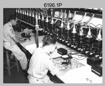
This collection of 10 photos was most likely taken at Lithographic Squadron, Army Survey Regiment, Fortuna, Bendigo in 1988. The main tasks undertaken by technicians in Photo Troop were most likely enlargements, reductions and duplication of map reproduction material, and processing of aerial photography.This is a set of 10 photographs of Photo Troop personnel and equipment from Lithographic Squadron at the Army Survey Regiment, Fortuna, Bendigo, 1988. The photographs were on 35mm negative film and were scanned at 96 dpi. They are part of the Army Survey Regiment’s Collection. .1) - Photo, black & white, 1988, BARCRO work area, SPR Gary Sievers. .2) - Photo, black & white, 1988, KLIMSCH Commodore camera, CPL Mick Gillham. .3) - Photo, black & white, 1988, KLIMSCH Commodore camera, CPL Mick Gillham. .4) - Photo, black & white, 1988, WILD U4A Diapositive Camera, SPR Rob Jones. .5) - Photo, black & white, 1988, WILD U4A Diapositive Camera, SPR Rob Jones. .6) - Photo, black & white, 1988, WILD U4A Diapositive Camera, SPR Rob Jones. .7) - Photo, black & white, 1988, WILD U4A Diapositive Camera, SPR Rob Jones. .8) - Photo, black & white, 1988, WILD U4A Diapositive Camera, SPR Rob Jones. .9) - Photo, black & white, 1988, Photographic camera enlarger, unidentified technician. .10) - Photo, black & white, 1988, SUPER CHROMEGA F Photographic camera enlarger. No personnel are identifiedroyal australian survey corps, rasvy, army survey regiment, army svy regt, fortuna, asr, litho -
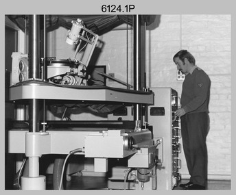
 Bendigo Military Museum
Photograph - Orthophotomap Workstation, Lithographic Squadron – Army Survey Regiment, Fortuna, Bendigo, 1988
This collection of four photos was most likely taken at Lithographic Squadron, Army Survey Regiment, Fortuna, Bendigo in 1988. Orthophoto mapping provided the Survey Corps with the capability to produce map products quickly in the event of a crisis. These are four photographs of equipment used by the Army Survey Regiment to produce orthophotomaps. The OR1 orthophoto projector and workstation was introduced in the mid-1980s. It was the second-generation equipment used to orthorectify colour and monochrome film aerial photography, replacing the system introduced in 1973. Orthorectification is the process of removing geometric distortions and scale errors/variations from images. Images have tilt and relief distortions that make it difficult to compare accurately a map and an image of the same geographic area. Once an image is orthorectified, features on the image are shown in their planimetric locations. These four photographs of orthorectification equipment in operation were taken at the Army Survey Regiment at Fortuna, Bendigo, 1988. The photographs were on 35mm negative film and were scanned at 96 dpi. They are part of the Army Survey Regiment’s Collection. .1) to .4) - Photo, black & white, 1988, WILD OR-1 Orthorectification Workstation, SPR Carmel (Butler) Fauth.No personnel are identifiedroyal australian survey corps, rasvy, army survey regiment, army svy regt, fortuna, asr, litho