Showing 1060 items matching "campus plan"
-
 Bendigo Historical Society Inc.
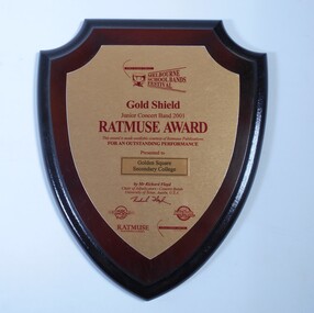
Award - School Sport Shields
Golden Square High School in the city of Bendigo, was established in temporary accommodation at Camp Hill Primary School in central Bendigo in 1960. With the completion of the new school's buildings, it moved to Golden Square in 1962, providing for Forms 1 to 6, now known as years 7 to 12. In 1978 it became a 7–10 school and was one of the original feeder schools to Bendigo Senior High School. In 1986, a Hearing Impaired Unit was established and in 1990 it underwent a name change to become Golden Square Secondary College. The Golden Square Secondary College campus closed on 28 November 2008. It merged with Kangaroo Flat and Flora Hill secondary colleges as part of the implementation of the Bendigo Education Plan. Its buildings were demolished. (Wikipedia https://en.wikipedia.org/wiki/Golden_Square_Secondary_College)Two wooden shields awarded to Golden Square Secondary College at the Melbourne School Bands Festival. Dark wood in the shape of a shield. a. Gold Shield awarded to the Junior Concert Band in 2001. TATMUSE AWARD for Outstanding Performance. Presented by Mr Richard Floyd. Sponsors represented by logos - Music Junction, Billy Hyde, RATMUSE (Music Publishers). Education Trust Vic. b. Yamaha Gold Award won by Golden Square Secondary College Intermediate Concert band 2003 at the Melbourne School Bands Festival. Presented to Symphonic Winds by Mr. K Waterworth. Award sponsored by Yamaha Music Australia, Billy Hyde Music. Blue border around a gold coloured shield.a. Sticker on the back of the Shield. "WINNING EDGE PRESENTATIONS Wholesale Trophy Framing and Giftware level 9 230 Collins Street Melbourne phone 9654 4911 Fax 9650 7106"gssc, sports top, music awards -
 Kew Historical Society Inc
Plan, Melbourne and Metropolitan Board of Works, Borough of Kew : Detail Plan No.1562, 1905
The Melbourne and Metropolitan Board of Works (MMBW) plans were produced from the 1890s to the 1950s. They were crucial to the design and development of Melbourne's sewerage and drainage system. The plans, at a scale of 40 feet to 1 inch (1:480), provide a detailed historical record of Melbourne streetscapes and environmental features. Each plan covers one or two street blocks (roughly six streets), showing details of buildings, including garden layouts and ownership boundaries, and features such as laneways, drains, bridges, parks, municipal boundaries and other prominent landmarks as they existed at the time each plan was produced. (Source: State Library of Victoria). This plan forms part of a large group of MMBW plans and maps that was donated to the Society by the Mr Poulter, City Engineer of the City of Kew in 1989. Within this collection, thirty-five hand-coloured plans, backed with linen, are of statewide significance as they include annotations that provide details of construction materials used in buildings in the first decade of the 20th century as well as additional information about land ownership and usage. The copies in the Public Record Office Victoria and the State Library of Victoria are monochrome versions which do not denote building materials so that the maps in this collection are invaluable and unique tools for researchers and heritage consultants. A number of the plans are not held in the collection of the State Library of Victoria so they have the additional attribute of rarity.Original survey plan, issued by the MMBW to a contractor with responsibility for constructing sewers in the area identified on the plan within the Borough of Kew. The plan was at some stage hand-coloured, possibly by the contractor, but more likely by officers working in the Engineering Department of the Borough and later Town, then City of Kew. The hand-coloured sections of buildings on the plan were used to denote masonry or brick constructions (pink), weatherboard constructions (yellow), and public buildings (grey). MMBW detail plan No.1562, in contrast to No.1561 includes the names of a large number of houses: in Barkers Road: ‘Ashwick’, ‘Owasso’, ‘Anadiha’, ‘Eurobin’, ‘Carlsruhe’, ‘Arlington’ and ‘Altyre’. Unnamed but clearly represented on the plan is what was then known as the ‘Auburn Heights Recreation Club’, which at this stage included a Bowling Green, a Croquet Green and two Tennis Courts. On the plan, Brougham Place, as it was then known, is represented. It was later renamed Daniell Place. The aforementioned Arlington is now the junior campus of Preshil. melbourne and metropolitan board of works, detail plans, mmbw 1562, cartography -
 Federation University Art Collection
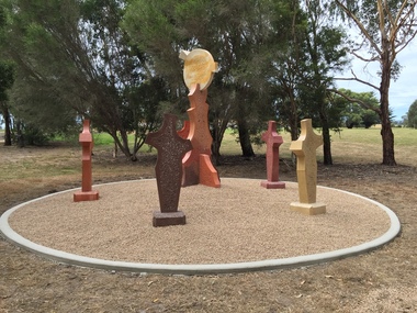
Sculpture, 'Mungo Moon' by Don Barrett, 2015
'Mungo Moon' by Don Barrett is the first sculpture erected on the Churchill Art and Culture Pathway. It was officially unveiled by Professor David Battersby on 15 April 2015 From Churchill & District News 16 October 2014 The Churchill Art and Culture Walking Pathway will have its official public opening on Saturday October 18, with a walk finishing at Federation University Australia’s Switchback Gallery at the Federation University Gippsland Campus. ... An important link on the newly developed pathway was recently completed with a path south of the FedUni Student West Residences. The path now allows walkers to turn off the Eel Hole Creek path before reaching Glendonald Estate and to follow a picturesque, tree lined walkway to join up with the footpath on the Eastern side of Northways Road. From there the footpath joins into Federation University’s network of walking paths that proceeds past the Switchback Art Gallery, down through the pine plantation and along Lake Kretlow and the Churchill Golf Course. Project Manager Mike Answerth, said the opening of the West Residences section of the path means there is now only one short link to complete. “We’re now very close to realising the project’s objective to join up all these walking paths to provide a continuous pathway that encompasses town, campus and parkland. The next stage of the project will be the completion of Latrobe City’s East West Link and the enhancement of the walking path with artistic and cultural features.” said Mr. Answerth. Head of Federation University Australia Gippsland Campus, Dr Harry Ballis, said the project had been made possible through the contributions of the five former Gippsland Education Precinct (GEP) partners. “The Art and Culture Pathway represents another important step in joining the Churchill township and the university campus as a physical and social entity,” Dr Ballis said. “This was an initiative of the GEP and it is pleasing to see it coming to fruition.” The path now reaches as far as the golf driving range but plans are already under way to connect with the Mathison Park board walk and pathway, which surrounds Lake Hyland in Churchill. When the loop is completed, residents and visitors will have an approximately 5km circular walking path which links up the Churchill town centre, Federation University Australia and Mathison Park. There are already art features along this route, including primary schools’ Bug Blitz totems near the Kurnai College school crossing, native vegetation and history panels near the Hare Homestead in Mathison Park, and outdoor sculptures in the pine trees near the Federation University Switchback Gallery. contemporaryA large sculpture in five pieces set in an external location. It is part of the Churchill Art and Culture Walking Pathway. Don Barrett’s work is mainly in concrete with added coloured oxides to portray the feeling of the Australian landscape. Barrett focuses on concepts of Australia’s short history and indigenous history. churchill art and culture pathway, barrett, don barrett, gippsland campus, federation university, churchill, sculpture -
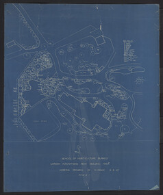
 University of Melbourne, Burnley Campus Archives
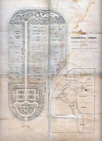
Photograph - Black and white print, Alfred Lynch, Plan of the Experimental Gardens, 1861-1991
Colour and black and white photographs of the original plan for the Ornamental Garden and Orchard in the Survey Paddock by Alfred Lynch in 1860 for the Horticultural Society of Victoria. See B92.630.experimental gardens, alfred lynch, plan, burnley gardens, ornamental garden, orchard, survey paddock, horticultural society of victoria, hsv -
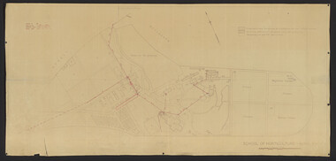
 University of Melbourne, Burnley Campus Archives
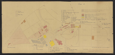
Plan - Coloured plan, Plan of Burnley Gardens, 1929?
Layout of gardens, farm buildings, orchard, etc. overlaid on part of Lands Department map. See paper catalogue for full descriptionPart of larger plan (Lands Department Parish Plan). Partly hand-drawn. Area bounded by Yarra River, Swan St, Glen Iris railway line. Shows Burnley Gardens layout, handwritten amendments and explanation of existing and proposed structures including: Pavilion, sketch of unbuilt Administrative Building, poultry yard, contours of old orchard, sketch for Plant Research Institute, ditch, silo, milking shed, laying pens. See aboveburnley gardens, pavilion, burnley school of horticulture, farm buildings, poultry -
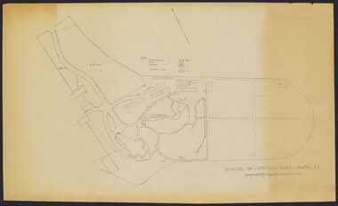
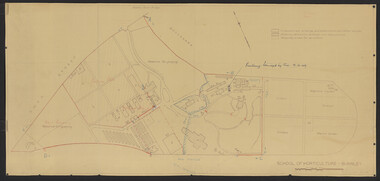
 University of Melbourne, Burnley Campus Archives
Plan - Coloured plan, Thomas H. Kneen, School of Horticulture - Burnley, 1948-1949
Colour-coded to show existing and proposed buildings, numbered and lettered to indicate use of buildings Related documents: B91.476, B91.484Plan with handwritten amendments by T.H. Kneen on 24.10.1949. Extensive explanation of existing and proposed structures at the College. Plan A: area bounded by Swan St., Yarra Boulevard, reserves for grazing, orchard and vegetable gardens along southern boundary. Amended 24/10/49 T.H. Kneent.h. kneen, burnley gardens, burnley school of horticulture, farm buildings -
University of Melbourne, Burnley Campus Archives
Plan - Sketch, Plan of Burnley Gardens, 1970-1980
Plans A and B. 2 identical hand drawn sketch plans of area bounded by manure bins, pumphouse to the east, milking shed and silo to the west: showing all buildings on the site.burnley gardens, buildings, burnley school of horticulture -
University of Melbourne, Burnley Campus Archives
Plan, Department of Public Works, Layout of UG and OM Cables sub-station area - Burnley Gardens, c. 1960
Copy of State of Victoria, Department of Public Works plan of cabling.cabling, department of public works, burnley gardens -
 University of Melbourne, Burnley Campus Archives
Plan - Sketch, School of Horticulture - Burnley, 1957
A,B,C,E paper copies, D, tracing paper copy of plan. Hand drawn sketch of central area of grounds. Figures given for acreage of ornamentals, crops and grazing although only 1 acreage is shown on plan. (E) has further annotation. Scale 1 inch:40 ft.burnley gardens, ornmental, crops, grazing, burnley school of horticulture -
 University of Melbourne, Burnley Campus Archives
Plan, School of Horticulture -Burnley, 1950
Same layout as plan at B91.0471, but showing PMG cables, and buildings existing, proposed and temporary or for demolitionPlan showing layout of PMG cables and PMG plant. Area bounded by Swan St., Yarra Boulevard, orchard, vegetable garden, market garden and S.W. Boundary to Stockman's Cottage. PMG layout handwritten. On same plan as B91.0484 (original) and B11.0383.burnley school of horticulture, orchard, gardens, vegetables, stockman's cottage -
 University of Melbourne, Burnley Campus Archives
Plan, Department of Public Works, Burnley School of Horticulture, c.1951
Department of Public Works, Melbourne, Victoria plan No. 51/66 of extension of grounds. Area bounded by Yarra River to north and south. Additional areas coloured. Position of new buildings and new house shown.burnley school of horticulture -
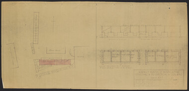
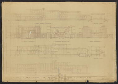 University of Melbourne, Burnley Campus Archives
Plan, New School of Primary Agriculture & Horticulture: Burnley Gardens, 1945
Original and photocopy of detailed architectural drawing and plan of new school by the Department of Public Works, Victoria Chief Architect, P. Everett.burnley school of horticulture, burnley gardens, percy everett -
 University of Melbourne, Burnley Campus Archives
Plan, Hilda Marriott ( Dance), Garden Plans by Hilda Marriott (Dance), 1947-1981
Set of 8 plans, including blue-prints, of various gardens, dated c. 1947 - 1981. See paper catalogue for complete list.Plans by Hilda Marriott Dance (1) Sketch plan and 2 blueprint copies of School of Horticulture Burnley. Garden Alterations New Building Area, Working Drawing by H. Dance, Scale ⅟₂₀"=1', 2/4/47, on reverse handwritten,"Proposed Garden Lay-out for New School Building (H. Dance-plan)." (NB Emily Gibson was also involved in the planning of this site.) (2) Tracing paper, paper and blueprint copies of Ararat & District Hospital Garden Plan - MacDonald Memorial & Court, Landscape Architect - H. Dance, Scale 1 inch=8 feet. Includes handwritten note, "Replacement for Ararat Hospital Nov. 1979," list of plants. (3) Blueprint Proposed Design for Garden Watermill Farm, Newbury for Norman Gadsden Esq., Scale ⅟₄₀"=1 ft. (4) Sketch Plan for Garden, Barcombe, Buangor - January 1981 by Hilda Marriott, Scale - Approximate Only - 1:40. (5) Tracing paper copy of plan of Garden at Plumhill, Templestowe, for Mr. & Mrs. Colin Smith. Hilda Dance, Designer 26/4/47, Scale ⅛"=1'. (6) Blueprint Garden House - Sketch. (7) Tracing paper and paper copies Ararat Medical Centre Courtyard Garden, Landscape Architect - Hilda Marriott, Scale - 1:25, Date 8.5.79. (8) Tracing paper copy National Trust of Australia (Victoria) The Heights, Newtown, Geelong Garden Plan, Scale 1:250, Drawn by - Hilda Marriott, Date 12.10.79.(1): on reverse handwritten,"Proposed Garden Lay-out for New School Building (H. Dance - plan)." (2): Includes handwritten note, "Replacement for Ararat Hospital Nov. 1979," list of plants.hilda marriott ( dance), burnley school of horticulture, students -
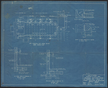 University of Melbourne, Burnley Campus Archives
Plan, K.O. Wood, Mechanical Ventilation System, 1946
Blue print of mechanical ventilation system for Assembly Hall by K.O. Wood, Mechanical Engineer. Dated 9.7.'46.k.o. wood, mechanical engineer, ventilation -
University of Melbourne, Burnley Campus Archives
Plan, Egg Laying Competition
Copy of plan for fencing. Area bounded by potting sheds, vehicle park, tennis court and railway line.fencing, tennis court, vehicle park, egg laying, competition -
 University of Melbourne, Burnley Campus Archives
Plan, Burnley Gardens 1945, 1945
"Plan of School of Horticulture. Burnley Gardens 1945," handwritten on reverse. Also, photocopy of part of it, enlarged.Plan of School of Horticulture. Burnley Gardens 1945, handwritten on reverse.burnley gardens, burnley school of horticulture -
 University of Melbourne, Burnley Campus Archives
Plan, Department of Public Works, Nursery Potting Soil Bins, 1941
Plan for removal and re-erection of soil bins by Dept. of Public Works. P.P.M. Engineer.burnley school of horticulture, nursery -
 University of Melbourne, Burnley Campus Archives
Plan, Burnley Layout: Security Fencing, 1948-1949
Copy of plan by L.H.B. of proposed new buildings, extensions and other works. Exisiting permanent buildings and those due for demolition. Second plan with sketch over showing proposed area for plant breeding, pasture, nursery, new fencing. Indication of building damaged by fire 19.12.1949.burnley school of horticulture, extensions, buildings, demolition, nursery -
 University of Melbourne, Burnley Campus Archives
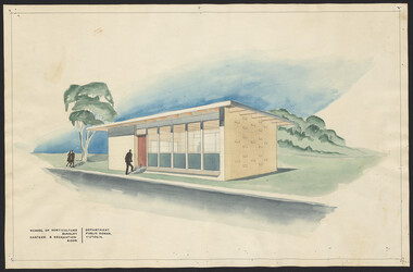
Plan - Sketch, Extension of Canteen and Recreation Room, C. 1961
Original coloured sketch.canteen, recreation room, burnley school of horticulture -
University of Melbourne, Burnley Campus Archives
Plan - Sketch, Widening road for parking. Buildings in College area occupied by other branches, c. 1950
Sketch plan.burnley school of horticulture, roads -
University of Melbourne, Burnley Campus Archives
Plan, Dorothy Kneen, Layout of Ladies' Committee and Refreshment Stalls, 1961
A. Layout of Ladies' Committee Stalls. B. Layout of Refreshment Stalls. For fruit tree pruning demonstration day 01.07.1961. By Dorothy Kneen.ladies' committee, burnley school of horticulture -
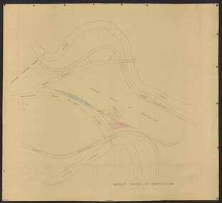
 University of Melbourne, Burnley Campus Archives
Plan, Burnley Gardens. City of Richmond. Parish of Jika Jika - County of Bourke, 1927
Part-coloured plan showing drainage, sewerage drains, taps and waterstops. Area bounded by Swan St. To N, Yarra River on E and Richmond Park on SW side. Contour lines of orchard depicted, laying pens and yards. Coloured area depicts pavilion with surrounding garden and paths layout pencilled in. Photo-Lithograph by Dept. of Lands & Survey, Melbourne by W. Butsonsewerage, drainage, lithograph, pavilion -
University of Melbourne, Burnley Campus Archives
Plan, Burnley Gardens. City of Richmond. Parish of Jika Jika - County of Bourke, 1927
Plan showing Burnley Gardens - bounded by Swan St to N, Yarra River to E, Richmond Park on S and W side. Photo-lithographed at Dept. of Lands & Survey by W.J. Butson. Plan shows old orchard, fowl sheds, coops and yards, milking shed, silo, nursery, glasshouse, fattening pens, dairy, garden, orchards area in S.W. area.burnley gardens, orchards, sheds, nursery -
University of Melbourne, Burnley Campus Archives
Plan, Burnley Gardens. City of Richmond. Parish of Jika Jika - County of Bourke, 1927
Plan showing Burnley Gardens - bounded by Swan St to N, Yarra River to E, Richmond Park on S and W side. Photo-lithographed at Dept of Lands & Survey by W.J. Butson. Plan shows old orchard, fowl sheds, coops and yards, milking shed, silo,nursery, glasshouse, fattening pens, gardens and orchards area in S.W. corner.burnley gardens, orchards, sheds, nursery -
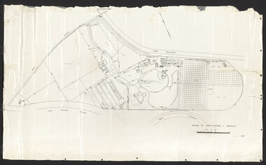
 University of Melbourne, Burnley Campus Archives
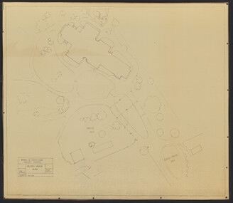
Plan, E.M. Gibson, Revised Roads Plan for Burnley Gardens, 1951
(1) 8 copies Plan by E.M. Gibson. (2) Report to Accompany Master Garden Plan for Burnley Gardens by E.M. Gibson 1.12.1949. Includes all areas around new Administration Building. Refers to help from C.R.T.S. students. Note: Master Garden Plan itself not found.e.m. gibson, burnley gardens, crts, students -
 University of Melbourne, Burnley Campus Archives
Plan, M. Drake et al, Site Location Plan of Incubator Building and Random Sample Laying Test for Burnley Gardens, 1967
Plan by Public Works Dept., Melbourne. M. Drake (draughtsman), R. G. Wilson, Chief Architect.m. drake, g.r. wilson -
 University of Melbourne, Burnley Campus Archives
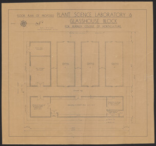
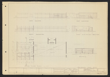
Plan, C.E. Richardson, Plan for Science Laboratory and Glasshouse Block, 1964
1 copy tracing paper, 2 copies paper. Drawn by C.E. Richardson.c.e. richardson, laboratory, glasshouse -
University of Melbourne, Burnley Campus Archives
Plan, Proposed Site for Plant Science Laboratory and Glasshouse Block, 1964
Plan on tracing paper.laboratory, glasshouse -
 University of Melbourne, Burnley Campus Archives
Plan, L.R.B. Simmons, New Soil Science Laboratory, 1973
Plans by Govt. Of Victoria Public Works Dept.: L.R.B. Simmons (Senior Project Architect), D.C. Bradbury (Chief Architect), Drawn by Aldo Bellarmo. A. Proposed addition to existing laboratory. B. Plan of Section and Elevation of proposed new Soil Science laboratory.laboratory, glasshouse, l.r.b. simmons, d.c. bradbury, aldo bellarmo -
University of Melbourne, Burnley Campus Archives
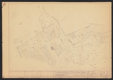
Plan, Road Diversions, 1881-1889
Sketch plan of Burnley College grounds showing road diversions in 1881 and 1889.burnley college