Showing 1234 items matching "crown land"
-
 Ballarat Heritage Services
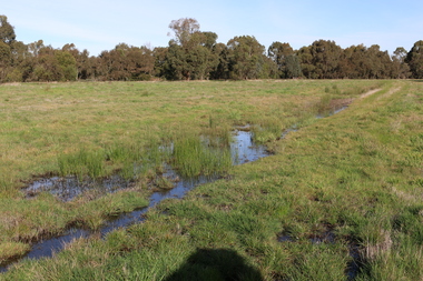
Photograph - Digital photograph, Winter's Swamp surrounds, April 2014
... Swamp was split between 2 separate Crown Land tenures ...The swamp was named after John (Jock) Winter. John Winter (Jock) was born in Berwickshire, Scotland. He married Janet Margaret Irving the daughter of Robert Irving, advocate, Bonshaw, Dumfries, Scotland. Winter died in Ballarat in 1875 and was buried at the Ballaarat Old Cemetery. He took up the run Bonshaw from 1841; Leigh River Buninyong 1842-46; Junction, Delatite, March 1851 to September 1862; with sons: Carag Carag and Corop, April 1857 to September 1872; Colbinabbin and Stewart’s Plains, April 1857 to December 1872; St Germains February 1867 to March 1871. (The name became Winter-Irving in 1890). Mr John Winter, who died on August 22 at the age of 72, was a man of some note it the mining community of Ballarat. He was a self-made man, and one of our oldest colonists, it being over a quarter of a century age since he took up county about Ballarat and settled at Bonshaw. He died very rich. It is calculated that if he had retained an interest in all his runs, his income must have been not less than £10,000 or £50,000 a year. Some eight or ten years ago he sold his Bonshaw pre-emption to the Bonshaw Gold mining Company for £20,000, and a few years later the ground belonging now to Winter's Freehold Company brought him £50,000 more, the payment being made at the requisition of the deceased in sovereigns. In these relations Mr. Winter has been closely identified with the mining industry at Ballarat. The deceased was a native of Lauder, in Berwickshire, and landed in Victoria several years before the gold discovery. BHS were commissioned by Ballarat Environment Network for a project on Winter's Swamp and Skipton Common. Winter's Swamp was part of Ballarat West Common. The principle task of this project was the delivery of a report outlining the history of European settlement in the Skipton and Cardigan/Ballarat districts as pertinent to the use of and impact on the natural environment of the two reserves Skipton Common and Winter Swamp. The report was delivered in digital form only. The report, upon completion, was presented to the Network’s Committee in order to discuss the project. The report identified and described the uses of Skipton Common and Winter Swamp, and their impacts. In particular, this report examined farming/grazing (official and informal), mining, vegetation removal (including the removal of woodlands for timber, grasslands for pasture improvement) & use of riparian areas for access to water and timber removal. Recording the more benign and environmentally friendly uses such as picnicking, community activities, nature walks and the roles of organisations such as Field Naturalists’ and Bird Observers’ clubs, school and scout/guide groups will be relevant in helping to depict overall community attitudes towards the reserves; e.g.: has the Common generally been viewed as little more than a grazing paddock and fire hazard; has Winter Swamp always been the unknown natural asset that seems to have been its lot for at least the past 40 years? In this regard, the more contemporary history of actions surrounding the use and management of the reserves is of particular interest, in view of the extant evidence at both reserves; e.g. the actions of the Shire of Ballarat in the 1980s in establishing Winter Swamp as something of a competitor to Lake Wendouree but with a more environmental bent (although almost none of the plants used are indigenous species, but that is part of the story); the trotting track constructed on Skipton Common in the 1960s following representations to Premier Henry Bolte and the cropping of the western section of the Common to raise funds for the town’s new swimming pool, the fertilizing of the land putting an end to the native grassland vegetation. There are obviously multiple sources of information to source in preparing the report, however sources that the contractor is specifically requested to consult are the Skipton Historical Society, the former Skipton Common managers (specifically Graeme Pett), the Cardigan Windermere Landcare Group and the Learmonth Historical Society (believed to hold many of the former Shire of Ballarat’s records pertaining to the Council’s role as the Committee of Management for both Winter Swamp and the Ballarat West Town Common – Winter Swamp was split between 2 separate Crown Land tenures). The contractor is also encouraged but not required to utilise community newsletters, such as the Skipton Community Newsletter, to publicise and seek information about the project. Skipton Historical Society (Mary Bradshaw) contacted on Thursday 12 June 2.30pm. Mary lived on a farm out of Skipton but is currently living in the township. She remembers walking along the creek of the Common especially in spring and autumn in bare feet and that it was a very pretty place. There were a few snakes around the waterway in summer. People put cows and a couple of horses on the commonage to graze. Graeme Pett has always lived close to the Common and would know a lot about it. Other possible contacts would be Nicole Petress, Secretary of the Progress Association, and the Corangamite Council, Camperdown. Mary can’t remember any photos in the Skipton Historical Society that pertain to the Common. Digital photos of Winter's swamp surrounds, later known as Mullawullah.winter, winter's swamp surrounds, winter's swap, john winter, ballarat environmental network, ballarat, mullawullah -
 Whitehorse Historical Society Inc.
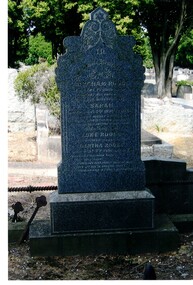
Photograph, Tombstone - Rooks family
The Rooks family emigrated from England in 1857. Abraham Rooks came to Forest Hill in 1862 and leased 79 acres. After 10 years of successful farming he owned the land. Abraham Rooks held the first church meetings in his home and in 1865 was one of the trustees to receive a crown grant to erect a chapel. In 1970 a school was attached to the chapel. Rooks Road is named after him.Coloured photo of the Rooks family tombstone - grave 226, Methodist section|Rooks, Abraham died 1 September 1889, aged 65 years|Rooks, Sarah died 2 January 1898, aged 66 yearsrooks, abraham, rooks, sarah, tombstones, rooks road, vermont -
 Whitehorse Historical Society Inc.
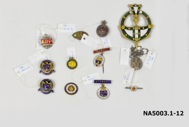
Medal - Badges, Approx 4. 1914 -1918 11. 1928-1929
1. Small circular white badge/red cross - bar pin 'A.N.C.M' 2. Oval medal with bar, long pin- red steward badge Royal Agricultural Show 3. Ditto - blue steward badge/brooch pin 4. AIF batch surmounted by crown 5. Oval Catholic religious medal/long chain 6. Oval badge: inscribed 7. Gold/Red/White/blue enamel badge - Free Trade 1929 8. Silver badge surmounted by crown/AP on red ground 9. Blue & gold badges: Eagle/shield/St John's Mitcham 10 & 11. Blue & gold badges: Eagle/shield/St John's Mitcham 11. Green & yellow circular on ring: Caufield Cricket Club 12. Ornate green/gold/white circular badge + pointed shaft1. Deo et Nomini Servimus A N C M 2. The Royal Agricultural Society of Victoria/Steward 3. The Royal Agricultural Society of Victoria/Steward 4. AIF - rest illegible/reverse: 4B349 5. Mostra TE ISS/Matrim/ Reverse: Congregation Des Enfants De Marie / scratched initials & date: B.Y.M 1891 6. P.J. Markham 678 Whitehorse Rd Mitcham Ringwood WNE 198 7.To promote land value, taxation and free trade. 4th International Conference Edinburgh 1929/Reverse: 50th anniversary of 'Progress & Poverty' by Henry George 8. Victoria ARP AH428 9&10. St John's Mitcham SJM Fide et Amorevinco/Reverse: scratched initials M.M. Millance 11. Caulfield Cricket Club1828-29 ccc/reverse: 20p.j. markham, mitcham post office -
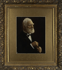
 Old Colonists' Association of Ballarat Inc.
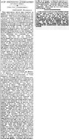
Photograph - Newsclipping, The Old Colonists' Association of Ballarat, 1888, 1888
The Old Colonists' Association Ballarat Inc. is a not for profit charitable organisation providing accommodation for elderly people. It manages a 27 Home retirement village at Charles Anderson Grove Ballarat. Accommodation is offered at significantly below market rates. It has been providing low cost accommodation to the elderly since the 1920s. The Association Council overseas the running of this facility on a voluntary basis. OLD COLONISTS' ASSOCIATION OF BALLARAT. (FROM OUR CORRESPONDENT.) BALLARAT, WEDNESDAY. This association, which was founded in August, 1883, and at first known as the Old Identities' Association, now has a roll of 450 members. The objects of the association are "to aid and assist indigent or suffering old colonists ; to raise a fund, by the voluntary subscriptions of the members and the aid of outside donations, for the purpose of relieving members in sickness and old age; for assisting those in extreme distress, to provide the shelter of a home for old and indigent pioneers of the gold fields, their widows, or anyone connected with the association, and in the event of the death of any member to have his remains decently buried, the association defraying the expenses of the funeral (providing that no funds or property are left by the deceased), and to attend the funeral if so desired by the relatives." The qualifications for member ship are good character and repute, and residence in the colonies for a quarter of a century. For some time the association had no property except the regular subscriptions, but about a year ago they obtained from the Minister of Lands the grant of a very valuable block of land in Lydiard-street, the Crown grant of which they received last week. This block has a frontage of 66ft to Lydiard street, worth at least £100 a foot. The ground was given to the association as a site for them to build a hall upon, and with so valuable an asset they had no difficulty in borrowing at 7 per cent, enough money to construct a hall. For revenue purposes the ground floor of the building has been made into four shops, and the rental from these, judging from the rentals of shops in the vicinity, will not only pay all the interest on the borrowed money, but over £200 a year towards clearing off the principal. The officers of the association are Messrs J. P. Murray, President; J. W. Graham and T. Stoddart, vice presidents; D. Fern, treasurer; and J. Fraser, secretary. The Old Colonists' Hall is an elegant looking building in Lydiard-street, lying between the newly-opened mining exchange and the Commercial Club house, and a few doors north of the Post Office. The style of the facade is classic. The lower portion of the front is constructed of Waurn Ponds stone, forming piers, and the upper portion of brick and cement, the background being tuckpointed. The centre bay is carried by two three quarter columns with Ionic cups, which support a pediment on which is set a cast of the Ballarat coat of arms. The four other bays are supported by pilasters with Corinthian caps mid partly fluted. The entrance is through a spacious circular headed doorway, the keystone of the arch of which bears a sculptured head, in marble, representing that of the president of the Old Colonists' Association here, Mr. John P. Murray. An ample vestibule leads to a wide stone staircase which ends at a spacious landing. The landing has a dome over the centre, with cornice and enrichments, and is lighted from above. The walls round the landing are panelled with marble slabs, which are to be appropriately inscribed in the future. On the first door are the rooms appropriated to the association. The principal of these is a hall 44ft x 33ft and 17ft high. This room is well ventilated and lighted from the back of the building with large windows, and the walls are finished with Keene's cement. The other rooms are committee room, 14ft x 16ft; secretary's, 14ft x 17ft, 6in; kitchen, bedrooms, bathroom, &c. The front portion of the first floor is arranged so that it may be let for offices, or utilised for club purposes. Suitable provision has been made throughout for lighting, ventilation, and means of egress. The architect for the edifice is Mr A. G. Legge, of this city, and the contractors are Messrs. Whitelaw and Atkinson, Irving and Glover, Reynolds, and J. Donaldson. The total cost of the building when completed, which will be in a few weeks, will be about £4,000. (The Argus, 10 May 1888)ballarat old colonists' club, charles anderson grove, old colonists' association -
 Southern Sherbrooke Historical Society Inc.
Map - photocopy
A photocopy taken from the original land sale map provided to the society through Karel Coxell of Stockdale & Leggo. The original maps are stored in large bound account books and were originally the propert of McNally Real Estate. The books are held (in 2A3 photocopy of plan of survey of part of Crown Allotments 20 & 21, section C, parish of Narre Worran, County of Mornington. Clements Ave and environs in Belgrave Heights"Villette Estate" in top LH corner, "Locality Plan" in bottom LH corner, "Not in sale" written on one block and crossed out. All handwritten in pencil on original. "Colby Drive " and "Verona Street" added in pencil to copy.land sales, advertisements, subdivision -
Queenscliffe Maritime Museum
Container - Basket, fisherman's
In July 1862, Victoria’s out-going Inspector of Fisheries and Oyster Beds, James Putwain, wrote a report of his observations of the colony’s commercial fisheries to deputy premier Charles Duffy. Irish-born Duffy was the Commissioner for Public Works, President of the Board of Land and Works, and Commissioner for Crown Lands and Survey, later to become Premier of Victoria. Reckoned to be of public interest, Putwain’s report was published in the Lands Circular of the day. Apart from its general historical interest in describing the fishes, fishing gear and boats of the time, this report remarks on the vulnerability of commercial fishermen to market wholesalers. It also comments on the particular role of Chinese, both as fishermen and as a discrete section of the fish-buying community at the time. FISHERIES OF VICTORIACane woven fisherman's basket for storage of catchfishing in port phillip and hobson's bay -
 Bendigo Historical Society Inc.
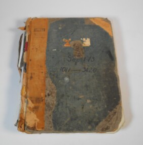
Administrative record - Application for allotments for sale 1908-1974
... , area, local land board schedule, classification, crown grant... Inc. History House 11 Mackenzie Street Bendigo goldfields Land ...Green cover book with brown leather spine. The book lists the applications for allotments of land for sale. The headings in the book are: number of application, date of registry, date of application, surname, Christian name and address, parish, allotment, section, area, local land board schedule, classification, crown grant, references and remarks. It covers the years 1908 -1974.Spine has a red label with gold letters. On the cover the remnants of a label, under in ink Sec.173, 1011-3420. At top left of the cover Sec.171 SHland sales, govrnment -
 Bendigo Historical Society Inc.
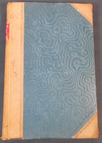
Legal record - Ledger of Reports of Land Sales by Auction
Blue and light brown ledger of land sales reports during 1898 to 1924. Blue water marked cover with light brown spine and corners, with red label on spine noting "12". Contains Crown Lands sales by auction documents, including purchasers' names, land section, allotment numbers and price. Ledger of Land Sales Reports 1915 sample reports of Colbinabbin, Kyabram & Rochester.land sales, auction -
 Bendigo Historical Society Inc.
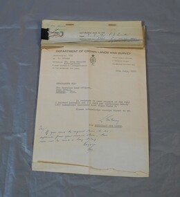
Legal record - Right to occupy a residential area
Four books of stubs. Originally the books had 20 right to occupy residence area forms. The stubs record the date of issue, the replacing right No., the fee paid, the receipt no. and a signature. only one of the books has the original form attached, two of the books have handwritten notes attached. One has a typewritten letter from a Mr. L. Gibney of the department of Crown lands and survey dated 24th July 1972 addressed to the district land officer, Bendigo. In the letter Mr. Gibney tells the officer in Bendigo that a pad containing 20 unnumbered residence area right forms D. The dates on the stubs are 17/04/1961, 16/04/1971, 07/09/1972, 08/05/1975land sales, right to occupy, government -
 Bendigo Historical Society Inc.
Tool - FOOD MINCER
Cast iron food mincer for seeding raisins, with handle & screw attachment for securing to bench or table, black wooden handle. Marked Landers Frary & Clark New Britain Conn. USA. Pat Nov 24.96 Wet the Raisins No 4 Crown.Landers Frary & Clarkdomestic equipment, food preparation, raisin seeder, k195 -
 Bayside Gallery - Bayside City Council Art & Heritage Collection
Map, Department of Crown Lands and Survey et al, Moorabbin, County of Bourke, Government Roads, 1920
The cadastral map of the Parish of Moorabbin in Victoria (L.6104) shows parish boundaries and land ownership 1920 when Sandringham was a Town. The government roads have been coloured in red pencil.moorabbin, county of bourke, map, plan, land subdivision, land titles, foreshores, hampton, beaumaris, highett, cheltenham, department of lands and survey, land owners, cartographic material, brighton, sandringham, town of sandringham, government roads -
 Bayside Gallery - Bayside City Council Art & Heritage Collection
Map, Department of Crown Lands and Survey, Moorabbin, County of Bourke, c. 1918
The cadastral map of the Parish of Moorabbin in Victoria (L.6104) shows parish boundaries and land ownership c. 1918 when Sandringham was a Borough.moorabbin, county of bourke, map, plan, land subdivision, land titles, foreshores, sndringham, hampton, beaumaris, highett, cheltenham, department of lands and survey, land owners, cartographic material, borough of sandringham, brighton -
 Bendigo Historical Society Inc.
Document - NEVILLE KING COLLECTION: OCCUPATION CERTIFICATE HOMESTEAD FARM NO. 15/939 IN THE NAME OF DAVID WILLIAMS AT A COST OF ONE POUND, DATED 25 SEPTEMBER 1897, 1897
Under the Western Australia 'the Homestead act 1893' an Occupation Certificate, Homestead Farm No. 15/939 for David Williams of Bendigo for 160 acres (near Woolkabunning near Bunbury WA); at a cost of one pound. Signed by order of the Commissioner of Crown Lands. Dated 25 September 1897. The land is marked and distinguished in the maps and books of the Department of Lands and Surveys of the said (WA) Colony as Williams Location No. 702. -
 Kew Historical Society Inc
Photograph, James Venn Morgan, c.1905
... , and induced his partners to invest their money with him in land. After..., and induced his partners to invest their money with him in land. After ...James Venn Morgan was known affectionately as ‘The Father of Kew’. Born in Somersetshire on February 21, 1823, he sailed to Australia in April, 1851. James V. Morgan, was a member of one of the first parties to leave for the diggings. At Chewton, near Castlemaine his party tried their luck in an abandoned shaft, and in two weeks returned to Melbourne after having won 35lb weight of gold. James Venn Morgan was content with his success, and induced his partners to invest their money with him in land. After obtaining the advice of a friend, the party negotiated with Mr Samuel Watts, of Collingwood, who had recently purchased land from the Crown, and from him they took over at £15 an acre about 32 acres of land in the district that is now known as Kew. This land extended from where the Kew Post-office now stands to the locality of the Boroondara Cemetery. Here it was that Mr Morgan decided to settle, and, after having had the land surveyed, the partners apportioned it by drawing straws for the four sections into which it had been divided. One of them sold his holding later in the year for £100 an acre, and was sorry for it afterwards. In 1853 Mr. Morgan built the first house in Kew, and this house is the one in which he still resides. Here with his wife, he settled down to market gardening and dairying. So successful was the new venture that he induced his father and other members of the family to come out to Australia to assist him. Gradually the district became settled, Mr. Morgan parted with a portion of his holding, and subdivided and built on the remainder, which he still retained. In 1884 he found himself in a position to retire from active business.He celebrated his 100th birthday in 1923. He was later to die in the same year. The Argus, 17 January 1923.Rare and historic hand-tinted framed portrait of one of the founding pioneers of the district.Hand tinted photograph in a gilt frame of the Kew pioneer James Venn Morgan (1823-1923).james venn morgan, kew - pioneer families, kew - landowners -
 Kew Historical Society Inc
Photograph, Anna Morgan, c. 1905
... , and induced his partners to invest their money with him in land. After..., and induced his partners to invest their money with him in land. After ...James Venn Morgan was known affectionately as ‘The Father of Kew’. Born in Somersetshire on February 21, 1823, he sailed to Australia in April, 1851. James V. Morgan, was a member of one of the first parties to leave for the diggings. At Chewton, near Castlemaine his party tried their luck in an abandoned shaft, and in two weeks returned to Melbourne after having won 35lb weight of gold. James Venn Morgan was content with his success, and induced his partners to invest their money with him in land. After obtaining the advice of a friend, the party negotiated with Mr Samuel Watts, of Collingwood, who had recently purchased land from the Crown, and from him they took over at £15 an acre about 32 acres of land in the district that is now known as Kew. This land extended from where the Kew Post-office now stands to the locality of the Boroondara Cemetery. Here it was that Mr Morgan decided to settle, and, after having had the land surveyed, the partners apportioned it by drawing straws for the four sections into which it had been divided. One of them sold his holding later in the year for £100 an acre, and was sorry for it afterwards. In 1853 Mr. Morgan built the first house in Kew, and this house is the one in which he still resides. Here with his wife, he settled down to market gardening and dairying. So successful was the new venture that he induced his father and other members of the family to come out to Australia to assist him. Gradually the district became settled, Mr. Morgan parted with a portion of his holding, and subdivided and built on the remainder, which he still retained. In 1884 he found himself in a position to retire from active business. He celebrated his 100th birthday in 1923. He was later to die in the same year. The Argus, 17 January 1923.Rare and-tinted framed photograph af Annie Morgan, the wife of one of the founding pioneers of the district.Hand tinted photograph in a gilt frame of Anna Morgan (nee Chidgey), the wife of James Venn Morgan. Anna Morgan was the wife of one of Kew's earliest pioneers and landowners. She died in 1915.anna morgan, kew - pioneers -
 Kew Historical Society Inc
Legal record - The Indenture, Crown Portion 86, otherwise known as 'The Morgan Deed', 1852 (and later)
... of conveyance of the land being all of Crown Portion 86, Kew, purchased... of the land being all of Crown Portion 86, Kew, purchased by John ...This indenture once formed part of the City of Kew's Municipal Collection. Cr. W.D. Vaughan in his history 'Kew's Civic Century' (1960) records on page 194 that: "The original deed of conveyance of the land being all of Crown Portion 86, Kew, purchased by John Quick, James Venn Morgan, Samuel Derrick and William Derrick was presented by the Historical Society of Victoria on behalf of Mrs Fryer, a daughter of the later J.V. Morgan, to the [Kew] Council on August 5, 1941. Crown Portion 86, comprised all the land between Cotham Road and High Street to an alignment opposite the east boundary of Glenferrie Road. On it the first residential house was built by Mr. J.V. Morgan in 1852." Following the donation, the Indenture was surrounded by other original related text and explanatory notes and framed. The resulting framed documents are the largest framed objects in the collection.The Indenture and the accompanying contextual documents are some of the most historically significant manuscripts to have survived since the settlement of Kew in the 1850s. They provide a link to Kew's most famous pioneering families.Framed 1952 Indenture recording the sale of land in Kew to pioneering Kew families.james venn morgan, john quick, william derrick, samuel derrick, kew (vic) - history, kew (vic) - pioneers, samuel watts, kew (vic.) — municipal collection -
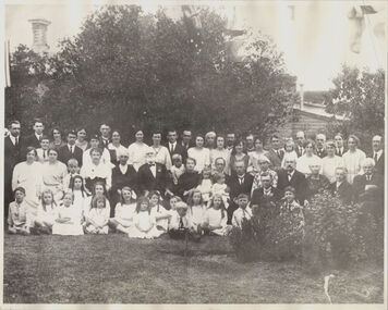 Kew Historical Society Inc
Photograph, James Venn Morgan's 100th Birthday, 1923
... purchased land from the Crown, and from him they took over at £15... purchased land from the Crown, and from him they took over at £15 ...1823-1923.MR. JAMES VENN MORGAN. "FATHER OF" KEW."In a Village in Somersetshire in England on February 21, 1823, a son was born to George and Sarah Morgan. The child was so delicate that his parents feared that he would not live. How little ground the parents parents had for their fears may be judged from the fact that the boy, christened James Venn Morgan is still alive and hale. He is able to exhibit with pride the paper with its faded ink on which a clergyman wrote the certificate of his baptism almost 100 years ago. But for some slight infirmities of sight and hearing, Mr. Morgan, who is within six weeks of completing the 100th year of his life, is in good health, and is well able to attend to his business affairs. His immediate cause for regret is that he is not now able to do a day's work in his garden, as he was 12 months ago. After spending his early life in England, where he learned his trade as shoemaker, Mr Morgan came to Australia in April, 1851. He carried letters of introduction to Mr. Tripp, a solicitor, of Melbourne, who strongly recommended him to begin business as a shoemaker, and accordingly he opened a shop at the corner of Swanston and Bourke streets, where the Leviathan Stores now stand, and was not long in working up a good connection. Among his customers at that time Mr. Morgan recalls Mr. Justice A'Beckett and many leading men in law and medicine of the day. Then the news was flashed through Melbourne of the discovery of gold at Ballarat. Nothing can give a clearer idea of the excitement this news caused in Melbourne than that Mr. Morgan, who was a member of one of the first parties to leave for the diggings, left uncompleted in his workshop one of a pair of riding boots he was making for Mr. J. B. Weir. As the purchase of suitable clothing would have taken time, he set out to make his fortune wearing a top hat. At Ballarat he stayed for five or six weeks, and returned to Melbourne with 10oz. of gold. He remained in the city long enough to finish the second of the two riding boots, and then, with three companions, set out for Chewton, near Castlemaine. Here fortune smiled. The party tried their luck in an abandoned shaft, and in two weeks returned to Melbourne again after having won 35lb. weight of gold. How Kew Was Born. Mr Morgan was content with his success, and induced his partners to invest their money with him in land. After obtaining the advice of a friend, the party negotiated with Mr Samuel Watts, of Collngwood, who had recently purchased land from the Crown, and from him they took over at £15 an acre about 32 acres of land in the district that is now known as Kew. This land extended from where the Kew Post-office now stands to the locality of the Boroondara Cemetery. At that time there was not a house in the district, and there was a fairly large population of aborigines, but no white men. Here it was that Mr Morgan decided to settle, and, after having had the land surveyed, the partners apportioned it by drawing straws for the four sections into which it had been divided. One of them sold his holding later in the year for £100 an acre, and was sorry for it afterwards. In 1853 Mr. Morgan built the first house in Kew, and this house is the one in which he still resides. Here with his wife, he settled down to market gardening and dairying. He tells with a laugh how he was paid 1/ a lb for the first potatoes he grew, and 1/ a quart for milk. So successful was the new venture that he induced his father and other members of the family to come out to Australia to assist him. How different Kew of those days was from the Kew of to-day will be understood from Mr. Morgan's statement that for weeks at a time they never saw a a white face other than those of the family. The blacks, he says, although very noisy, were entirely friendly. Gradually the district became settled, Mr. Morgan parted with a portion of his holding, and subdivided and built on the remainder which he still retains. In 1884 he found himself in a position to retire from active business. Youth in Old Age. In Mr Morgan's garden, which is a large, one trees which he and his father planted more than 60 years ago are still bearing heavy crops of apples. Mr. Morgan has been a widower since 1915. He has three daughters all of whom are married, and numerous grandchildren and great-grandchildren. One of the great-grand children reccntly informed Mr. Morgan that he was about to be married. Perhaps the most striking characteristic of Mr. Morgan to-day is his activity. Not only does he move about with surprising alacrity, but is able to go into the streets and attend to his business affairs with but little fatigue The Argus, 17 January 1923, p.12.This work forms part of the collection assembled by the historian Dorothy Rogers, that was donated to the Kew Historical Society by her son John Rogers in 2015. The manuscripts, photographs, maps, and documents were sourced by her from both family and local collections or produced as references for her print publications. Many were directly used by Rogers in writing ‘Lovely Old Homes of Kew’ (1961) and 'A History of Kew' (1973), or the numerous articles on local history that she produced for suburban newspapers. Most of the photographs in the collection include detailed annotations in her hand. The Rogers Collection provides a comprehensive insight into the working habits of a historian in the 1960s and 1970s. Together it forms the largest privately-donated collection within the archives of the Kew Historical Society.A group portrait on the occasion of the 100th birthday of James Venn Morgan in 1923. Dorothy Rogers used this photograph in 'A History of Kew' (1973). It faces page 17. In the book, the caption reads "JAMES VENN MORGAN'S 100TH BIRTHDAY ANNIVERSARY. The party was held at 'Morganville'. Mr Morgan is shown with a group of descendants."James Morgans 100th Birthday Party. james venn morgan, kew, model dairy, dorothy rogers -
 Kew Historical Society Inc
Plan - Subdivision Plan, St Helliers Estate, Kew, circa 1910, c.1910
Pru Sanderson, in her groundbreaking ‘City of Kew Urban Conservation Study : Volume 2 - Development History’ (1988), summarised the periods of urban development and subdivisions of land in Kew. The periods that she identified included 1845-1880, 1880-1893, 1893-1921, 1921-1933, 1933-1943, and Post-War Development. These periods were selected as they represented periods of rapid growth or decline in urban development. An obvious starting point for Sanderson’s groupings involved population growth and the associated economic cycles. These cycles also highlighted urban expansion onto land that was predominantly rural, although in other cases it represented the decline and breakup of large estates. A number of the plans in the Kew Historical Society’s collection can also be found in other collections, such as those of the State Library of Victoria and the Boroondara Library Service. A number are however unique to the collection.Subdivision plans are historically important documents used as evidence of the growth of suburbs in Australia. They frequently provide information about when the land was sold on which a built structure was subsequently constructed as well as evidence relating to surveyors and real estate and financial agents. The numerous subdivision plans in the Kew Historical Society's collection represent working documents, ranging from the initial sketches made in planning a subdivision to printed plans on which auctioneers or agents listed the prices for which individual lots were sold. In a number of cases, the reverse of a subdivision plan in the collection includes a photograph of a house that was also for sale by the agent. These photographs provide significant heritage information relating house design and decoration, fencing and household gardens.In the subdivision of part of Crown Portion 82, bordered by John and Sackville Streets and Cotham and Burke Roads, over 100 lots were offered for sale. In addition to the designated lots, a number of key locations are also identified. These include the Genazzano Convent to the north of Cotham Road, the Reservoir, St Hilary’s and the land holding of Colonel Parnell on the corner of John Street and Cotham Road. On the Plan, No. 5064, is the handwritten name ‘St. Hellier’s Estate’. St. Helliers, the home of the Dumaresq family is shown beside St. Hilary’s.subdivision plans - kew, st helliers estate -
Kew Historical Society Inc
Journal, Kew Historical Society, Newsletter No.130, March 2020
... Golden Triangle: Crown Land Portion 86 / Margaret Robinson p4 ...Historic Sporting Clubs / Robert Baker p1. History News: Monthly Meetings, 2020 Kew Festival, Australian Heritage Festival p3. Kew's Golden Triangle: Crown Land Portion 86 / Margaret Robinson p4. Woodbury Ladies' College 1903-1920 / Robert Baker p6. John Percy Jones: a socialist in Kew / David White p8. The Humes of Studley Park: 5 Studley Avenue and the Hume Pipe Garden / Julie King p10. Donations to the collection / Robert Baker p11. Membership & Donations p12.Published quarterly since 1977, the newsletters of the Kew Historical Society contain significant research by members exploring relevant aspects of the Victorian and Australian Framework of Historical Themes. Frequently, articles on people, places and artefacts are the only source of information about an aspect of Kew, and Melbourne’s history.non-fictionHistoric Sporting Clubs / Robert Baker p1. History News: Monthly Meetings, 2020 Kew Festival, Australian Heritage Festival p3. Kew's Golden Triangle: Crown Land Portion 86 / Margaret Robinson p4. Woodbury Ladies' College 1903-1920 / Robert Baker p6. John Percy Jones: a socialist in Kew / David White p8. The Humes of Studley Park: 5 Studley Avenue and the Hume Pipe Garden / Julie King p10. Donations to the collection / Robert Baker p11. Membership & Donations p12.kew historical society (vic.) -- periodicals., kew historical society (vic.) -- newsletters, kew historical society (vic.) -- journals -
 Royal District Nursing Service (now known as Bolton Clarke)
Photograph - Photograph, black and white, c.1953
... in the community over the next years. In 1875 J.B.Scott purchased Crown ...Melbourne District Nursing Society (MDNS) moved into 452 St. Kilda Road, in 1953. Seven Ford Prefect cars were purchased by the Society in the early 1950s which became the beginning of a full MDNS, later called Royal District Nursing Service, fleet of cars which would be used by their District nurses to visit patients in the community over the next years.In 1875 J.B.Scott purchased Crown Land on the corner of St Kilda Road and Arthur Street. During the 1890’s an “unpretentious grey building” was built on the site. Known as ‘Airlie’, major additions were carried out during the 1920s and 30s to this historic mansion. From its founding in 1885 until 1891 the Trained nurse (Nurses) of the Melbourne District Nursing Society (MDNS) worked from their own homes which were located in the vicinity of their areas (districts). In November 1891 MDNS was able to rent a two story terraced house at 66 Cardigan Street, Carlton, at £65 a year, which contained accommodation for three Trained nurses (Nurses) and one pupil nurse as well as being used as their Headquarters. The Nurses left from there each morning and returned at the end of their shift to write up their book work before retiring for the day. Three years later they moved into a larger terraced house at 49 Drummond Street Carlton which was rented at ‘a very moderate rental’. There was a Board room, apartments for the Nurses and pupil nurses, a large dispensary which patients could attend each evening to have prescriptions signed and bottles refilled with ‘homely remedies’ and elixirs, which were administered for e.g. Consumptive cases. Doctor’s prescriptions were filled at the Pharmacy. Cupboards containing donated blankets and bedclothes for needy patients were kept in this room, and it was here where the Nurses kept their nursing bags which were refilled at the end of each shift ready for any emergency and for the next day. A list of Doctors the Nurses could call was kept by the telephone. The home also had a kitchen where nourishing soup was made and distributed twice a week to the needy. Milk was also distributed when needed. In 1902 they moved into rented premises at 188 Leicester Street, Carlton and two years later, in 1904, to premises at 5 Royal Terrace, Nicholson Street, Fitzroy. They remained there for ten years. In June 1914 at last the Society had sufficient funding to purchase their own terraced premises, ‘Floraston’ 39 Victoria Parade, Collingwood which was their Headquarters and Nurses Home. In 1926 the After-Care Home for recovering patients, (later called After-Care Hospital) was built by the Society next door to No. 39, running from 41-47 Victoria Parade (became No. 45); the District Trained nurses (Sisters) continued to live at No. 39. In 1953 ‘Airlie’ at 452 St Kilda Road was offered by the Government as part of an agreement to split the management of the Society and the After Care Hospital. On 26th November 1953 the MDNS moved its Headquarters to 452 St Kilda Road. Renovations and alterations were however restricted by limited funds so it was not until 1/12/1954 that the Hon. W. P. Barry, Minister of Health, officially opened the building. MDNS was given Royal patronage in 1966 and became Royal District Nursing Service (RDNS). In January 1983, Headquarters of the Royal District Nursing Service at 452 St Kilda Road was classified by the National Trust. The citation in support of the classification said “The house is of historical interest as the boyhood home of Stanley Melbourne Bruce, later Lord Bruce, Prime Minister of Australia from 1923-1929.” Black and white photograph of Melbourne District Nursing Society Headquarters, 452 St Kilda Road, Melbourne. The photo, taken on the corner of Arthur street, is of a two storey building and several cars and gives a unique view of St Kilda Road in the 1950s (pre high rise buildings) This large grey two storey Italian style building, has four roman column, arched Arcadia to the right of a polygon shaped bay window on the ground floor; an arched Arcade on the second floor, and three long windows above the bay window on Arthur Street. Turning the corner onto St. Kilda Road is a three arched Arcadia running towards the one window seen on the polygon shaped bay window. Arcadia is repeated on the upper storey. A balustrade is in front of the Arcadia on the upper storey and again around the flat roof. Two chimneys can be seen. A spiked metal fence runs in front of the building. To the left of this building are two white double storey buildings and some medium sized trees. On Arthur Street, two Ford Prefect cars, one with the passenger side door partly open, a Vanguard car and another make of car can be seen.royal district nursing service, headquarters, 452 st kilda road melbourne, melbourne district nursing society, mdns, mdns transport, rdns -
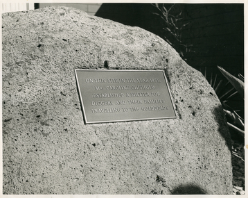 Royal District Nursing Service (now known as Bolton Clarke)
Photograph - Photograph, black and white, 30 08 1967
... Centre which is situated on Crown Land, is in recognition for her ...The rock and attached plaque to Caroline Chisholm stand in front of the Royal District Nursing Service (RDNS) Essendon Centre. It was unveiled at the opening of the Centre on the 30 August 1967.The plaque has a deep silver colour background, light silver colour writing with gold coloured edging.Caroline Chisholm visited the goldfields of Victoria in 1854 and was horrified by the conditions en-route. The Memorial plaque to Caroline Chisholm, in front of the RDNS Essendon Centre which is situated on Crown Land, is in recognition for her work in establishing, with Government assistance, shelter sheds about a days walk apart, to enable the prospectors and their families heading for the goldfields shelter on their way. Caroline Chisholm, a Philanthropist, began her work in Madras in 1834 founding a Female School of Industry for the daughters of European soldiers. They were taught to read, write, cook, keep house and were given instructions in nursing. After coming to Sydney in 1838, she set up accommodation for poor young unemployed migrant women and families. This work was extended when she arranged employment for assisted immigrant women and families into the countryside, many times travelling with groups of young women to check their employment conditions. In seven years she placed 11,000 people in homes and employment. On her return to England she fought for, and won, free passage to Australia for wives and children of former convicts, and for children left behind in England by circumstances, when the family migrated. She established the Family Colonisation Loan Society in 1849, which set up a saving scheme for emigrants, and later loaned them half of their passage to Australia. The Society's Agents found them employment on arrival, and the loan was paid back within two years by a humane payment scheme. At first they used emigrant ships, but then the Society provided ships with much improved conditions, and this led to the upgrading of the passenger Act.. The Chisholm's lived in Kyneton for several years, returning to Sydney for health reasons, before going back to England where Caroline died, aged 68 years, on the 25th of March 1877.Black and white photograph of the Memorial plaque to Caroline Chisholm. The rectangular plaque sits on a rough light grey rock, and has light colour writing and edging, on a dark grey background. The inscription on the plaque is in five lines and reads: "On this site in the year 1855"/, "Mrs Caroline Chisholm"/, "Established a Shelter for"/, "Diggers and their families"/ "Travelling to the Goldfields"/.Photographers stamp. Quote No. GJ 56rdns, royal district nursing service, rdns centre, caroline chisholm, memorial plaque -
 Melton City Libraries
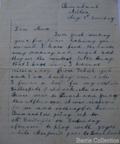
Letter, Letter to Martha Myers, Unknown
Letter was sent to Burnbank, former Ann Dowling (Miers) 1866 Crown Grant. In 1867 she married Henri Miers and their house was located on the site near the Myers Gully part of Ryans Creek. Built in 1867 and later named “Burnbank” by Martha Myers after the Street in Ballarat were she lived before arriving in Melton in 1907. “Burnbank” was vacated by Martha to her new house built on the family land in McKenzie Street. A demolition order imposed by the Housing Commission and it was pulled down by the family in 1969. It was the home of the family and stood for over 100 year.Letter from Edna Barrie and Bruce Myers, children of Martha Myerslocal identities -
 Mont De Lancey
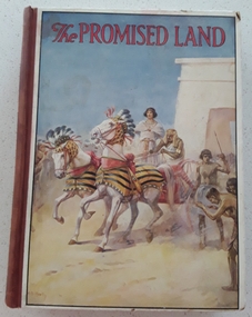
Book, Catherine Shaw et al, The Promised Land, 1928
A collection of Bible stories about The Promised Land retold by Catherine ShawHardcover children's religious instruction book, The Promised land, with picture of an Egyptian chariot race in biblical times with red lettering for title at top of illustration. Brown spine with black printed title, 6 crowns and publisher name. Black and white and coloured illustrations throughout.fictionA collection of Bible stories about The Promised Land retold by Catherine Shaw books, fiction, biblical stories, children's books -
 Melton City Libraries
Pamphlet, Dry Stone Wall Driving Trail, Unknown
"The dry stone walls provide a tangible link to the area’s white settlement, and they remain a symbol of the profound change in land usage from the original Kulin custodians to the European arrivals of the nineteenth century. The bulk of dry stone wall construction in Victoria occurred between the 1850s and 1880s. The gold rush of the early 1850s in particular inspired a flurry of construction. At this time, labour previously available for shepherding livestock dried up, as men gravitated to the goldfields to seek their fortunes. This necessitated the building of fencing to contain the district’s growing number of sheep, cattle and horses. An explosion in surveying, subdivision and the sale of Crown lands also contributed to a boost in construction. Government regulations that punished pastoralists for allowing their livestock to stray provided further incentive to fence-off previously open expanses of land. The major benefit of this type of fencing was that it utilised the materials at hand; the plentiful grey basalt that scattered the landscape. In the case of the dry stone walls built around Melton, the characteristic round or oval shape of the volcanic fieldstones on the western plains inspired some distinctive designs.54 Another advantage of dry stone walls was their ability to withstand the ravages of flood, fire and drought often experienced in the district. This durability accounts for the fact that many of these fences still exist today". Dry Stone Wall trail brochure/pamphlet for visitors provided by Melton Visitor Information Centrecouncil, landscapes of significance -
 Phillip Island Conservation Society Inc.
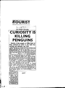
Work on paper - Newspaper cutting, Unknown journalist, the Express newspaper, Wonthaggi, "Tourist Curiosity is killing penguins", 30.01.1964
... management of Crown Land by Phillip Island Shire Council ...Due to increased numbers of tourists in the post-World War Two era, and the increased popularity of the Penguin Parade, without sufficient public education or protection of the penguin habitat, many Little Penguins perished during the 1960s. Trampling, unsupervised interference with the birds, unrestricted access to their dune habitat, plus predation by foxes, cats and dogs, led to most of the rookeries outside of the Summerland patrolled areas - such as on the west and north Phillip Island coasts, and parts of the south coast - being obliterated by the mid 1970s.this article is highly significant as it was published shortly before the establishment of the Phillip Island Conservation Society Inc in 1968, which commenced agitation to make management of Crown Land by Phillip Island Shire Council and government bodies accountable for protection of wildlife habitat on Phillip Island.photocopy of newspaper cutting. Black print on white paper. 3--1-64phillip island, penguin parade, little penguin, habitat destruction, penguin parade committee, shell house, -
 City of Kingston
Photograph - Black and white, 20 December 1945
Cheltenham is a suburb in the City of Kingston that was originally established as a rural market gardening community. The area is bordered by Highett, Mentone and Heatherton. The market gardens, farms and paddocks have gradually been sub-divided into housing and industrial estates. The Southland shopping centre is a major feature of the area.Cheltenham was established as a rural market gardening community. The Le Page family lived in Cheltenham since 1854 when Nicholas Le Page, a tailor from the Channel Island of Guernsey, bought two acres of land on Chesterville Road near Bernard Street to establish a market garden. Over the years the Le Pages purchased more land in the area. In 1875-76 Nicholas' son Frank and his wife Mary built 'Daphne Cottage' near the corner of Bernard and Wilson Streets. n the 1940s Frank's son, Everest Le Page, bought five more lots of land in Chesterville Road from the Tuck family. The Le Pages grazed horses, ponies and cows on this land, and grew pumpkins, carrots, parsnips, onions, potatoes and cabbages. Many buildings and locations within in Cheltenham commemorate the Le Page family's contribution to the Cheltenham community.Aerial photograph taken in 1945 of the Cheltenham district within the City of Kingston. The image includes Chesterville Road, the future site of Turner Road pool (now Waves) and Highett Reserve, (top left), Jellicoe Street, Argus Street, Bernard Street, Wilson Street, the Methodist Children Homes (now Southland), McIvor Street, Goulburn Street, Nepean Highway, Jamieson Street and Barker Street (bottom left), market gardens and paddocks. In the top centre of the image, "Daphne Cottage", the home of Frank T. Le Page is visible on the corner of Bernard and Wilson Streets. Much of the land depicted in this image was owned by the Le Page family. This image is possibly from the collection of aerial photographs commissioned by the Department of Crown Lands and Survey and taken by Adastra Airways.Black and white ink: 57250 White print: VIC-170 57250 20.12.45 Run 6 PROJ. No. 5 MELB. METROP AREA Black type 10200 FTS 30' LENS 20.12.45cheltenham, market gardens, industry, le page family -
 City of Kingston
Photograph - Black and white, 20 December 1945
This aerial photograph depicts the changing landscape of Cheltenham and Highett since WWII. Photographed in 1945, there is a mix of urban dwellings and industrial development and precedes the major transformation of Cheltenham with the development of the Southland shopping centre in the 1960s and expansion in the 1990s.A large part of Cheltenham was originally established as a rural market gardening community. The railway line and station brought urban development to the area and in the north, the Highett area was dominated by the Highett Gas Works. Cheltenham became a major destination for shopping in the 1960s with the opening of Southland.Aerial photograph taken in 1945 of Cheltenham and Highett within the City of Kingston. The image includes the Highett Reserve, (top right), the Methodist Children Homes (now Southland), Nepean Highway and Jamieson Street. Highett Gas Works is visible in the top left and the land now named William Fry Reserve at the intersection of Bay Road and Nepean Highway. A visible large parcel of land on the corner of Bay Road and Nepean Highway was developed in the 1990s as the west side addition to Southland. The densely vegetated area in the upper right sector of the image is now dense with housing. Tulip Grove, Heather Grove and Gilford Street are visible bottom left. This image is possibly from the collection of aerial photographs commissioned by the Department of Crown Lands and Survey and taken by Adastra Airways.Black ink: 57252 White lettering: VIC-10 57252 20.12.45 [lens information indecipherable] PROJ. No.5 MELB. METROP AREA Black pencil: 80highett, cheltenham, highett gas works, urbanisation -
 City of Kingston
Photograph - Black and white, 20 December 1945
This aerial photograph depicts the changing landscape of Cheltenham and Highett since WWII. Photographed in 1945, there is a mix of urban dwellings and industrial development and precedes the major transformation of Cheltenham with the development of the Southland shopping centre in the 1960s and expansion in the 1990s.A large part of Cheltenham was originally established as a rural market gardening community. The railway line and station brought urban development to the area and in the north, the Highett area was dominated by the Highett Gas Works. Cheltenham became a major destination for shopping in the 1960s with the opening of Southland.Aerial photograph taken in 1945 of Cheltenham and Highett within the City of Kingston. The image includes the Highett Reserve, (top right), the Methodist Children Homes (now Southland), Nepean Highway and Jamieson Street. Highett Gas Works is visible in the top left and the land now named William Fry Reserve at the intersection of Bay Road and Nepean Highway. A visible large parcel of land on the corner of Bay Road and Nepean Highway was developed in the 1990s as the west side addition to Southland. The densely vegetated area in the upper right sector of the image is now dense with housing. Tulip Grove, Heather Grove and Gilford Street are visible bottom left. This image is possibly from the collection of aerial photographs commissioned by the Department of Crown Lands and Survey and taken by Adastra Airways.Black type: Reverse lettering VIC-10 57252 20.12.45 [lens information indecipherable] PROJ. No.5 MELB. METROP AREA White lettering: Reverse writing 57252cheltenham, highett, highett gas works, urbanisation -
 Bendigo Historical Society Inc.
Document - LANDS OFFICE REGISTER OF CROWN LANDS SOLD SANDHURST, 1855 - 1869
Journal: black hard cover journal with buff spine and corners. Front cover badly damaged Written on spine ' S.I. Sales 1855 - 1869' '05' written in red ink on top of spine. On front cover 'G.W. Groves' written in blue ink under torn cover. Blue lined pages contain details of crown lands surveyed in district of Sandhurst, town, suburban and country. Details of parish, area, date of sale, price and name of purchaser. Indexed by parish on first page.Lands Officeland sales, lands office, land sales, land surveyed, sandhurst, bendigo -
 Whitehorse Historical Society Inc.
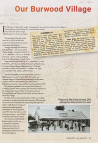
Article - The Bulletin newsletter, The Bulletin Jun - Aug 2022, Our Burwood Village, June 2022
... of Nunawading at the time. The sale of Crown Land in Ballyshanassy 02/05 ...An article about the first settlement surveyed in 1858 in the Burwood area known as Ballyshanassy. It later became Norwood and finally Burwood in 1879.An article about the first settlement surveyed in 1858 in the Burwood area known as Ballyshanassy. It later became Norwood and finally Burwood in 1879.An article about the first settlement surveyed in 1858 in the Burwood area known as Ballyshanassy. It later became Norwood and finally Burwood in 1879.ballyshanassy, albers ernest, boundary road burwood east, dempsey