Showing 13425 items
matching golden-gate-bridge
-
 Linton Mechanics Institute and Free Library Collection
Book, Vare, Daniele, The gate of happy sparrows, [n.d.] [1937?]
xv, 257 p.fictionfiction -
 Healesville Sanctuary Heritage Centre
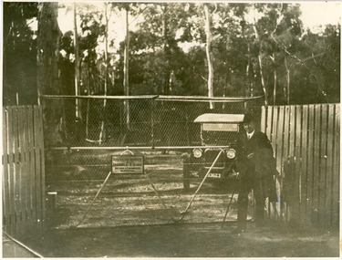
Photograph - Print, Dr Colin MacKenzie at the main gate
Mr Alf Wright, Keeper, presented this photograph to the Sanctuary on 2nd August 1957This is one of a few remaining 1930s photographs of the sanctuary. Only photo in this collection of the front gate. Historically, scientifically and socially important to the State of Victoria.Sepia photograph. Original photograph. Donated.This photograph has an inscription on back donating it to the sanctuary. "'Dr Colin Makenzie, at the Main Entrance. Early 1930s. Australian Institute of Australian Research, Breeding & Experimental Reservation. Presented by Mr. Alf Wright, who was employed here at the time as a keeper. 2.8.57 WRG" - Note: Inscription states 1930s but should be 1920ssir colin mackenzie, 1930s -
 Federation University Historical Collection
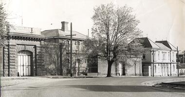
Photograph - Black and White, SMB: Gates of the Ballarat Gaol: Centenary Year, 1970, c1970
Black and white photograph showing the main gates of the gaol - panoramaBoard above the gates: "THE SCHOOL OF MINES - 1870 Centenary Year 1970" -
 Ringwood and District Historical Society
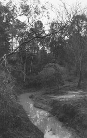
Photograph, Mullum Creek from bridge in Warrandyte Rd. Looking east, 1972
Written on backing sheet, "Mullum Creek from bridge in Warrandyte Rd. Looking east, 1972" -
 Ringwood and District Historical Society
Photograph, Mullum Creek from bridge in Warrandyte Rd. Looking east, 1973
Written on backing sheet, "Mullum Creek from bridge in Warrandyte Rd. Looking east, 1973". -
 Ringwood and District Historical Society
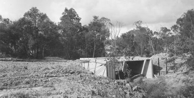
Photograph, Bridge over Mullum Creek under construction, Oliver Street. 1963
2 photographsWritten on back of photograph, "Bridge over Mullum Creek, Oliver Street. 17/11/1963" -
 Ringwood and District Historical Society
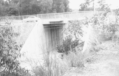
Photograph, Eastfield Road bridge just opened - looking east. Ringwood 1978
Written on back of photograph, "Late 1978. Eastfield Road bridge just opened - looking east." -
 Ringwood and District Historical Society
Photograph, Warrandyte Road Bridge over Mullum Mullum Creek, Ringwood 1986
Written on back of photograph, "3.8.86. Ringwood. Warrandyte Road Bridge over Mullum Mullum Creek". -
 Ringwood and District Historical Society
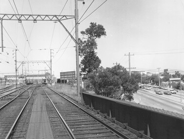
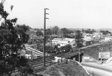
Photograph, Ringwood Railway Station overlooking Maroondah Hwy viewed from bridge over Warrandyte Road in foreground, 1974
Written on back of photograph, "Ringwood Railway Station, 1974 from bridge over Warrandyte Road." -
 Ringwood and District Historical Society
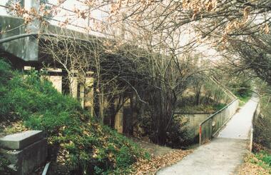
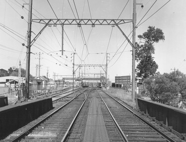
Photograph, View from Ringwood Clocktower overlooking Wantirna Road railway bridge and Thanet Street corner - Dec. 1969
Black and white photographWritten on back of photograph: "Wantirna Rd bridge. from clocktower, 1969". Thanet Street corner. -
 Ringwood and District Historical Society
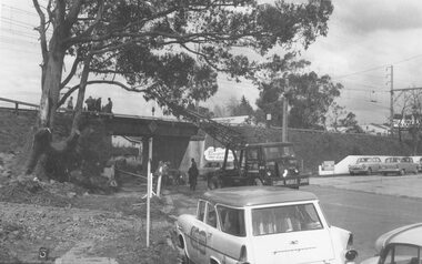
Photograph, Maroondah Highway West, Ringwood- 1965. Wantirna Road bridge widening
Black and white photograph (2 copies)Written below one photograph: "Wantirna Road railway bridge- preparing to widen underpass, 1965. -
 Ringwood and District Historical Society
Photograph, Ringwood Railway Station, 1974, viewed from bridge over Warrandyte Road in foreground, looking west
Black and White photographWritten on back of photograph, "Ringwood Railway Station, 1974. From bridge over Warrandyte Road". -
 Melbourne Tram Museum
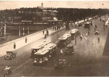
Photograph - Photograph Card, Kelly Collection, View Productions, Princes Bridge / Batman Ave tram terminus, Photo c1920
Photograph Card - folded card, blank inside of Cable Trams, motor cars, pedestrians crossing Princes Bridge over the Yarra River with the Princes Bridge / Batman Ave tram terminus with a shelter in the background. Shows five cable tram sets. Has railway signals and Government House in the view. Produced by View Productions GPO Box 1858 Sydney, from the Kelly Collection, titled "On the Princes Bridge, circa 1920, Melbourne, Victoria, Australia". Has the Publishers logo on the rear.trams, tramways, princes bridge, batman ave, swanston st, cable trams, shelters -
 Orbost & District Historical Society
black and white photographs, Howard D. Bulmer, first half 20th century
This bridge was built in the 1920s as a road and rail bridge, and was partly washed away by flood waters in 1934. After the end of the first World War the Victorian Railways considered an extension of the railhead across the river at Orbost, and in 1922 a new timber and steel girder structure, a joint Country Roads Board — Victorian Railways venture, was built and completed at a cost of £41,000 (the steel girders came from the Flinders Street viaduct reconstruction). Subsequently it was decided not to take the railway across the river, and the bridge has only been used by road traffic. This is a pictorial record of an early bridge across the Snowy River at Orbost.A large black / white photograph of the Orbost Snowy River bridge. There is a large copy as well as a postcard copy in sepia.on front - Snowy River Bridge Orbost H.D. Bulmer - photo - Lake Tyers.snowy-river-bridge-orbost -
 Kew Historical Society Inc
Plan - Subdivision Plan, J Hurrey, Section 115 in the Parish of Boroondara Near Richmond Bridge, 1853
Despite the plans claims that it is a subdivision near the Richmond Bridge, Section 115 was located at what is now Camberwell Junction. While the plan only lists government roads rather than named streets, the section was located on the east side of Burke Road, stretching up the hill from the current Junction. Research on Trove, conducted by Kerry Fairbank, discovered an advertisement for unsold lots in Section 115 which clarifies the extent and location of subsequent land sales in the original section. The original article can be viewed through the link in the catalogue record. The interesting link to Kew is the reference to James Beavan as the purchaser of lots 14 and 15. The historian Gwen McWilliam has notes that a Mr Beavan changed his name from Bevan. The Bevans were descendants of the Derricks family of Kew. This subdivision plan is the earliest original map or plan in the collection which shows parts of what is now the City of Boroondara, dating from circa 1853. It provides important information for researchers on subsequent subdivisions following the original land sales in [Camberwell] Boroondara. The site, on the east side of Burke Road is a highly-significant and historic site. This is believed to be the only extant copy of the subdivision in public collections.A small plan on parchment listing 28 lots, between one and two acres each, for sale in Section 115 in the Parish of Boroondara, dating from 1853 when the portion was subdivided.Obverse: Lot 16 "Joseph Duval", Lots 14 & 15 "James Beavan". Other annotations (measurements) are unreadable. Reverse: "KH-981 / Section 115 in the Parish of Boroondara / Near Richmond Bridge / 1640T. / J Duval / 14-15 J. Beavanparish of boroondara, subdivision plans - camberwell, section 115 - boroondara, subdivision plans -- camberwell (vic), riverscape road, burke road, camberwell junction -
 Orbost & District Historical Society
black and white photograph, c1920-1954
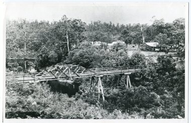
This is a copy of "THE BRIDGE AT BOGGY CREEK, NOWA NOWA, LAKE TYERS." which is a Rose Stereograph Co postcard. Boggy Creek Bridge was built in 1916 as part of the Bairnsdale to Orbost extension to the main Gippsland Railway, and is situated in the middle of the township of Nowa Nowa, crossing a steep-sided and well-timbered creek-valley. This section of the line closed in 1987. This bridge plays a major part in the identity and history of the town of Nowa Nowa, This item is associated with the East Gippsland Railway.A large black / white photograph of a large wooden bridge across a creek. There is a house and outbuildings in the background on the right. It is in a bush setting. on back - "Boggy Creek bridge - Nowa Nowa 1887 LaTrobe Collection"boggy-creek-bridge east-gippsland-railway -
 Eltham District Historical Society Inc
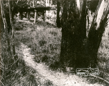
Photograph, Tree and Trestle Bridge, Eltham
Black and white photograph showing a track winding past an old gum tree towards the Trestle Bridge at Eltham in the distancepioneers and painters, bridges, eltham -
 Ringwood and District Historical Society
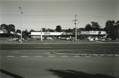
Photograph-B&W, Joan Walker, East Ringwood 2000-Burnt Bridge Shopping Centre, Maroondah Highway, 2000
East Ringwood 2000-Burnt Bridge Shopping Centre, Maroondah Highway- B&W Photo from Album 6501 -
 Federation University Historical Collection
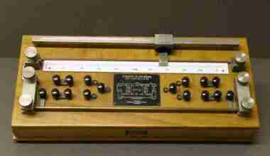
Instrument - Scientific Instrument, J.L. William Instruments, Kelvin Bridge
In 1993 this item was held in the Mt Helen Physics Department Optics Laboratoryc1870 as SMB start date but could be much earlier Student's type Kelvin Bridge Type KB/3R mounted on polished wood, with a range pf 0.000010HM to 0.1 OHM.scientific instruments, kelvin bridge, optics laboratory -
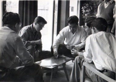 International House, The University of Melbourne
Photograph (Item), Richard Shiell, 10 Ways of Filling in Time at International House - 4: "One Quick Rubber (Bridge was very popular)", 1960
A quiet moment playing cards in the Common Room, this photo illustrates the many benefits International House presented to its residents, giving space for social and everyday interactions with diverse peoples, to the benefit and enjoyment of all. This photograph comes from an 'Album of Student Activities 1960', compiled and presented to International House by Soedjadi Satrosoegito & Richard Shiell.social, card games -
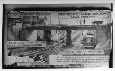 Melbourne Tram Museum
Photograph - Black and White, Epson Road Rail Bridge under construction, Early 1925
Image shows a newspaper photo of the MMTB U Class Tram 203 on temporary track at east side of excavation for underpass in Epson Road Flemington with Racecourse railway line to eliminate level crossing. The road was often closed to all traffic, including trams on race days by the railways. The work was completed in April 1925MMTB U Class trams were built for the former operator NMETL, with the photo showing an early level crossing abolition project. Black and White photo Epson Road Rail Bridge under construction with MMTB U Class tram on temporary track tramways, trams, epson road bridge, u class, flemington, tram 203 -
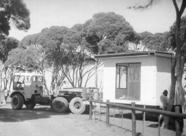 Churchill Island Heritage Farm
Photograph - Photograph of demountable on back of truck
Churchill Island Heritage Farm has a large photograph collection dating from the nineteenth century. This series provides an insight into the early days of Churchill Island as a Conservation site.Black and White photograph of the old Churchill Island ticket booth that used to be located on the bridge. Catalogue number written on reverse in pencil. Handwritten on reverse 'The ticket office at Bridge on loan from Golden Homes Wonthaggi Courtesy Mr Henry Donahue'churchill island -
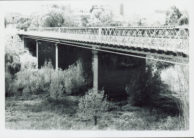 Kew Historical Society Inc
Photograph - Outer Circle Railway Viaduct
The heritage listed Fairfield Bridge was originally constructed for the Outer Circle Railway to bridge the Yarra River between East Kew and Fairfield stations. In the 1930s it was converted for vehicular traffic. In the 2010s a new concrete bridge was erected beside it to increase vehicular capacity.Print copy, enlarged from original snapshot, of the former railway viaduct crossing the Yarra and linking Kew and Fairfield. The original photo predates the conversion of the viaduct into the Chandler Highway Bridge in the 1930s, when the Bridge was adapted to carry vehicular traffic. The date on the reverse indicates the date of donation rather than the date on which the photograph was taken. CHANDLER HIGHWAY BRIDGE OVER RIVER / (ORIGINALLY PART OF OUTER CURCLE RAILWAY) / OCTOBER 1977railway viaduct -- kew (vic.), fairfield bridge, fairfield railway viaduct, outer circle railway, sir john monash -
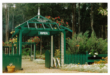 Marysville & District Historical Society
Photograph (Item) - Colour photograph, 1992
A colour photograph of the garden entrance and bridge at Arbor Green Gardens in Marysville. This cottage, along with most of the buildings in the township, was destroyed in the 2009 Black Saturday bushfires.A colour photograph of the garden entrance and bridge at Arbor Green Gardens in Marysville.Garden Entrance & bridge./ Arbor Green Galleries/ 1 Falls Rd. M'sville./ Spring 1992marysville, victoria, australia, photograph, accommodation, arbor green cottage, 2009 black saturday bushfires -
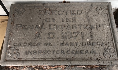 Coburg Historical Society
Artwork, other - Plaque (intended) for Murray Road Bridge, Bluestone Plaque intended for Murray Road Bridge, 1871
The plaque was originally intended for the Murray Road Bridge. The Murray Road Bridge is of state historical and architectural significance. With the Newlands Street Bridge it is one of a pair of bluestone bridges constructed by prison labour in Coburg and is situated within the immediate vicinity of the Pentridge Prison. The bridge has one of five largest spans of stone bridges built in Australia, of which at least three survive. (VHR)BluestoneErected by the Penal Department A.D. 1871 George Oliphant Duncan Inspector General -
 Greensborough Historical Society
Photograph - Digital Image, Plenty Bridge Hotel, Lower Plenty, 1870s
Lower Plenty Hotel. This photograph shows the original Plenty Bridge hotel with Lower Plenty bridge in the foreground. The hotel was built c1858 and the bluestone bridge in the 1860s to replace the earlier toll bridge built in 1858.The close proximity of the hotel to the bridge is an indication of the importance of these river crossings in the mid 19th centuryDigital copy of black and white photographlower plenty, plenty river, plenty bridge hotel, lower plenty bridge, lower plenty hotel -
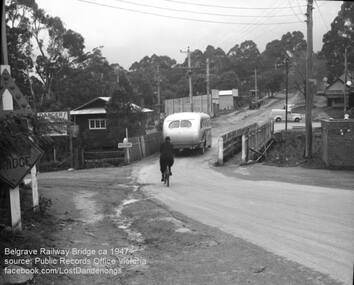 Southern Sherbrooke Historical Society Inc.
Photograph, Belgrave Railway Bridge, 1947
Belgrave railway bridge looking towards Bayview Road from Terrys Ave, 1947. It shows a bus crossing the bridge onto (now) Belgrave-Gembrook Road, followed by a male cyclist wearing a dark overcoat and bowler hat. A man wearing a homburg hat is crossing the footbridge beside the main bridge towards the main street. There is a pale van parked (or driving past) a dairy on the corner of Bayview Rd and Belgrave-Gembrook Road. A brick toilet block is shown with a sign saying 'MEN' on a nearby lamp post. -
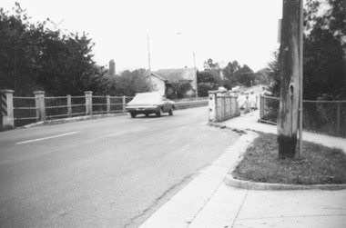 Ringwood and District Historical Society
Photograph, Warrandyte Rd. Bridge, Ringwood. 1978
Written on back of photograph, "Warrandyte Rd. Bridge". Catalogue card dates photograph, "1/5/78" -
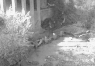 Ringwood and District Historical Society
Photograph, Warrandyte Rd. Bridge over Mullum Creek, Ringwood, showing stumps of old piles (undated)
Poor quality, blurry photographWritten on back of photograph, "Warrandyte Rd. Bridge over Mullum Creek showing stumps of old piles". -
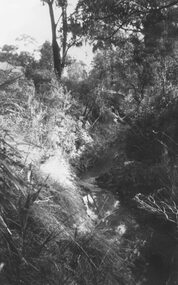 Ringwood and District Historical Society
Photograph, Mullum Creek, 75 yds east of Warrandyte Rd. Bridge 1964
Possibly May 1971 as per item 2979?Typed below photograph, "Mullum Creek, 75 yds east of Warrandyte Rd. Bridge in centre". 1964