Showing 1102 items matching "information map"
-
 Melbourne Tram Museum
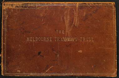
Document - Folder, Kemp & Boyce Printers, "Melbourne Tramways Trust - Cable Tramways", March 1889
Plans and documents prepared by George Duncan for the Melbourne Tramways Trust showing details of the track construction, drainage and costs for the construction of the Melbourne cable tram and horse tram system for the Melbourne and Tramway Omnibus Co. Part 1 - track cross sections for both cable and horse trams and various rail weights - lbs/yard part 2 - details costs and mileages for each liine, report from George Duncan and remnant part of a printed map missing the lower half. part 3 - drainage report detailing the works and cost for each line. part 4 - continuation of drainage report - and last part of the book Map printed on cloth - blue print - showing the various lines. Note the Windsor to St Kilda line shown as a horse tram line, but was built as a cable line - the last to be opened.Yields information about the construction of the cable tram system by the Melbourne Tramway TrustFolder - heavy card leather covered covers with gold lines around the edges and gold blocked title. Has marbled glued end papers, containing 9 cloth backed blue print drawings, 22 printed sheets and two foldout maps. The lower half of the first fold out map has been torn out and lost. The second fold out map, a cloth backed blue print.Date stamped in two places with "The Melbourne Tramways Trust Engineers 9 Mar 89" (1889), in two places.tramways, trams, cable trams, mtt, mtoco, melbourne tramway trust, construction, drainage, maps, george duncan, track work, costs -
 Melbourne Tram Museum
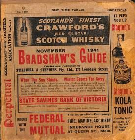
Book - Bradshaws Guide - November 1941, Stillwell & Stephens Pty Ltd
Provides detailed information on Victorian railways country timetables, suburban trains, lists of post offices, Victorian and Commonwealth Government officials and elected representatives, and tramways - all night services, first and last cars, including Sandringham and St Kilda services. Provides a detailed guide to services in Victoria, including public transport.Book - 194 pages, 9 sections stapled paper titled "Bradshaws Guide - November 1941" Priced 8d, No. 1029. Has a fold out map of the VR Country and suburban lines. Includes many advertisements.victoria, tramways, melbourne, timetables, railways, guides, bradshaws guide, advertisements -
 Melbourne Tram Museum
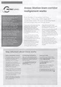
Pamphlet - Metro Tunnel - Anzac Station tram corridor works, Rail Projects Victoria, 11/2022
Provides information about the works planned to realign tram tracks at the Metro Tunnel Anzac station, following the completion of the surface works. Gives timing, tram routes affected, plans of the proposals, contact details. All St Kilda Road routes would be affected from 27/11/2022 to 17/12/2022, tram stops would be closed, bus replacement services. includes works to remove the Glenhuntly Road level crossing at Glenhuntly Station. Yields information about the trackworks for the future Anzac Station interchange and St Kilda Road services.Set of two documents issued by Rail Projects Victoria (Metro Tunnel) and Yarra Trams with regard to the reallignment of tram tracks at Anzac Station Nov. 2022 1 - Metro Tunnel - Works proposed, maps - 6 A4 pages 2 - Yarra Trams - Service Changes St Kilda Road works - 4 A4 pages.anzac station, metro tunnel, tramways, st kilda road, domain road, domain interchange, park street, track work, tram tracks, glenhuntly road, glenhuntly station, level crossings -
 Melbourne Tram Museum
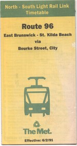
Document - Timetable - Route 96 - East Brunswick - St Kilda Beach, The Met, 2/1991
Timetable dated 6-2-1991 provides information on the East Brunswick to St Kilda Beach via Bourke Street services, including a map, route description, time points, fare secrtions and contact details. Published by The Met. Has the words "North-South Light Rail Link" on the top of the document. Yields information about Route 96 tram services on the St Kilda light rail line.Document - 10 fold sheet - Timetable - Route 96 - East Brunswick - St Kilda Beachtramways, timetable, route 96, east brunswick, st kilda beach, light rail, the met -
 Melbourne Tram Museum
Document, Ministry of Transport, Melbourne Public Transport Map - No. 12, 1982
Map No. 12 - Includes description of tram and bus routes, private bus routes. On the front cover is composite image of Melbourne public transport vehicles. Has contact details for bookings and lost property etc and how to use the map. Priced at 40c, issue No. 12 of c1982. Has details of the then new Travelcard ticket system. Yields information about Melbourne public transport services in 1982.Fold out map (36 sections 9 across x 4 deep), "Public Transport Map", coloured of Melbourne's Tram and Bus routes, route numbers, rail lines, detailed for the central part of Melbourne and the outer Metropolitan services.tramways, melbourne, tram services, bus services, railways, travelcard -
 Melbourne Tram Museum
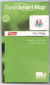
Document, Ministry of Transport, "Travel Smart Map - Port Phillip", 2010
Gives extensive details of walking cycling Public Transport in Port Phillip. Printed 2010. Yields information about Port Phillip transport and other services in 2010Map - pocket - 28 fold - showing walking, cycling and public transport in the City of Port Phillip, using a Melway Map base along with public transport information, Metcard, cycling and walking groups.tramways, melbourne, tram services, bus services, railways, port phillip, cyclists -
 Melbourne Tram Museum
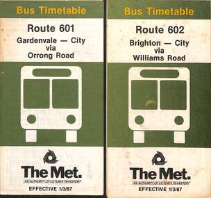
Document - Timetable - bus - Routes 601 and 602, The Met, 3/1987
Timetables dated 1-3-1987 - provides information on ticketing, timing points, with a description of the route and a map. Both routes were privately run for many years prior to The Met taking them over in April 1985. See reference. 1 - Route 601 - Gardenvale - City - via Orrong Road 2 - Route 602 - Brighton - City via Williams RoadYields information about bus services in the Brighton area.Set of two, The Met timetables - both 8 fold folded sheets for routes 601 and 602.timetable, the met, route 601, route 602, buses, brighton, gardenvale -
 Melbourne Tram Museum
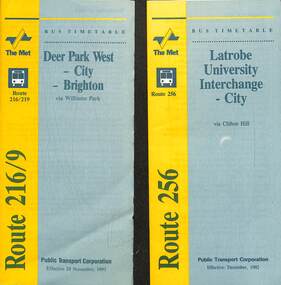
Document - Timetable - bus - Routes 216, 219 and 256, Public Transport Corporation (PTC), 1992
Timetables - provides information on ticketing, timing points, with a description of the route and a map. 1 - Route 216 Deer Park West to Brighton and 219 - Sunshine Park to Brighton. The 216 route was extended to Melton at weekends. Dated 29-11-1993. Route 216 absorbed the former route 601 following the implementation of Swanston Walk during 1992. 2 - Route 256 - Latrobe University Interchange to City, dated Dec 1992. Yields information about bus services in the Brighton, Deer Park, and Latrobe university services.Set of two, PTC timetables - 7 or 8 fold folded sheets for routes 216, 219 and 256.timetable, buses, deer park west, brighton, latrobe university, ptc -
 Melbourne Tram Museum
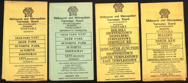
Ephemera - Timetables - MMTB Buses, Melbourne & Metropolitan Tramways Board (MMTB)
Timetables - provide information on ticketing, fares, timing points, with a description of the route and a map. Not all services had been allocated a route number at the time. 1 - Deer Park West - Sunshine - Footscray - City - Jan 1975, including a separate weekend timetable' 2 - Box Hill - Shoppingtown - Templestowe - May 1975 3 - Bulleen - North Kew City - Routes 203, 204, 205, 206, 208 and 209 - August 1972 4 - North Altona - City - route 232 - June 1979 5 - Clifton Hill - Elsternwick route - route 246, Point Ormond - route 247 and 248 - June 1974 6 - La Trobe University - Northland - West Heidelberg - City - routes 256, 251, 253, 254, 252, 255 - August 1974 7 - Warrandyte - Park Orchards - Ringwood - routes 273, 274, 275 - Feb. 1974 8 - Warrandyte - Donvale - Templestowe - Shoppingtown - City - routes 276, 277, 278, 294, 278, 280, 299, 268 - April 1975 9 - East Kew, Box Hill Doncaster, Shoppingtown - routes 284, 285, 270 - May 1974 10 - Box Hill - Mitcham, East Doncaster, Ringwood - routes 287, 286, 288, 282, 283, 272 - March 1974' 11 - Box Hill - North Blackburn - route 290 - March 1974 12 - Fishermans Bend - City - routes 233, 235, 237 - Feb 1979.Yields information about MMTB Bus services during the 1970s.Set of twelve MMTB Bus timetables - multifolded printed on yellow paper, except for Deer Park timetables for Saturdays and Sundays printed on green paper.timetable, the met, buses, box hill, doncaster, templestowe, warrandyte, elsternwick, fishermans bend, deer park, altona, sunshine, footscray, shoppingtown -
 Melbourne Tram Museum
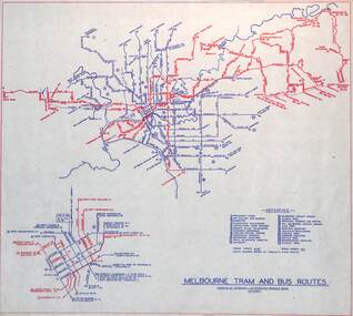
Map, Melbourne & Metropolitan Tramways Board (MMTB), "Melbourne tram and bus routes", c1961
Map showing MMTB tram and bus routes following the closure of the Point Ormond line on 22/10/1960 and before the closure of the Footscray lines on 10/3/1962. Shows route numbers at termini and along the route and points of interest in a reference table. Yields information the MMTB services c1961.Map - printed in two colours on paper. Two copies held.tramways, map, mmtb, tram, bus, routes -
 Melbourne Tram Museum
Map - CD - Sands McDougal Map Melbourne c1906, Sands McDougall
... Reg item 6572 for the actual map. Yields information about ...Detailed scan of the Sands McDougal Map in colour showing Melbourne's cable trams, railways, Essendon Tramways, NMETL and the Victorian Railways line to Brighton from St Kilda. Includes the MTOCo horse tram lines and the Caulfield horse tram lines. See Reg item 6572 for the actual map. Yields information about Melbourne and its tramways in 1906CD in a plastic case - black with clear cover.CD marked "Sands & McDougal Map c1906"cable trams, tramways, map, sands mcdougal, nmetl, vr trams, horse trams -
 Melbourne Tram Museum
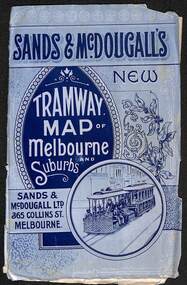
Map, Sands McDougall, "Tramway Map of Melbourne and Suburbs", c1906
Shows railways, cable and electric tram lines c1906. One of a number of maps produced by Sands McDougall of Collins St. Includes the MTOCo horse tram lines and the Caulfield horse tram lines. See items 2885 and 6573 for other editions. Yields information about Melbourne c1906 and its public transport lines. Map - folded sheet of paper 5 sections wide x 4 sections or folds deep contained within a light grey paper cover titled "Tramway Map of Melbourne and Suburbs"maps, melbourne, cable trams, tramways, railways, horse trams, nmetl, vr trams, sands mcdougall -
 Melbourne Tram Museum
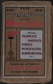
Map, Sands McDougall, Map of Melbourne and Suburbs showing Tramways, Railways, Streets, postal districts, Quarter-Mile Radii etc", c1919
Shows railways, cable and electric tram lines c1919. One of a number of maps produced by Sands McDougall of Collins St. Includes the MTOCo zoo horse tram lines, the PMTT, HTT and MBCTT lines, but not the FNPTT or the FTT lines. See items 2885 and 6573 for other editions. Yields information about Melbourne c1919 and its public transport lines. Produced by Sands and McDougall Pty Ltd of Collins St Melbourne. folded sheet of paper 6 sections wide x 6 sections or folds deep contained within a brown paper cover titled "Map of Melbourne and Suburbs showing Tramways, Railways, Streets, postal districts, Quarter-Mile Radii etc", showing both cable and electric tramways. maps, melbourne, cable trams, tramways, railways, horse trams, nmetl, vr trams, sands mcdougall, mbctt, pmtt, htt, zoo horse tramway -
 Melbourne Tram Museum
Map, Ministry of Transport, Melbourne Public Transport Map - No. 9, 1979
... and how to use the map. Yields information about Melbourne public ...Map No. 9 - Includes description of tram and bus routes, private bus routes. Has contact details for bookings and lost property etc and how to use the map. Yields information about Melbourne public transport services in 1979Fold out map (27 sections 9 across x 3 deep), "Public Transport Map", coloured of Melbourne's Tram and Bus routes, route numbers, rail lines, detailed for the central part of Melbourne and the outer Metropolitan services.tramways, melbourne, tram services, bus services, railways, travelcard, maps -
 Melbourne Tram Museum
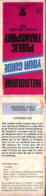
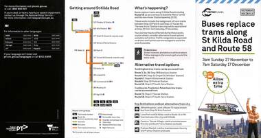
Pamphlet, Public Transport Victoria (PTV), Buses replace trams along St Kilda Road and Route 58, Oct. 2022
Pamphlet - Buses replace trams along St Kilda Road and Route 58 - issued for the track relocation at Domain Junction / Anzac station during the period 27-11-2022 to 17-12-2022. Actual work took a day longer due to weather. Similar pamphlets would have been issued for other routes that used St Kilda Road. Includes maps, alternative routes. Issued by Public Transport Victoria. Part of the Metro tunnel works.Yields information about the reconstruction of Domain Junction for the future Anzac station.Pamphlet - four fold DL - full colour on semi gloss paper. Two copies held.tramways, route 58, anzac station, domain interchange, track work, bus replacement -
 Melbourne Tram Museum
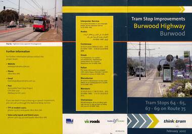
Pamphlet, VicRoads, "Tram stop improvements Burwood Highway Burwood", Feb. 2007
Pamphlet dated Feb. 2007 detailing the installation of platform or super stops in Burwood Highway Burwood in four locations. Has location map. Part of the VicRoads Yarra Trams Think Tram project. Route 75.Yields information about the installation of super stops in Burwood Highway during 2007.Pamphlet - 3 fold DL - full colour.trams, tramways, super stops, platform stops, route 75, burwood highway, burwood -
 Melbourne Tram Museum
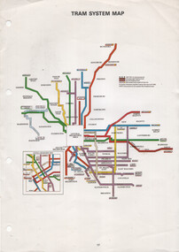
Map, The Met, "Tram System Map", c1990
Tram system map published by The Met to show the various Melbourne tram routes, route numbers, principal road names, suburbs and tram routes within the Central Business District.Provides information about Melbourne tram routes c1990Printed A4 full colour sheet with four punch holes on left hand side.tramways, melbourne, the met, map, tram routes, routes -
 Tatura Irrigation & Wartime Camps Museum
Document, Otto von Drehnen
Otto von Drehnen was a prominent Adelaide citizen from the late 1800s, a successful businessman. He was elected President of the Deutsche Club & appointed the Consul General for Austro-Hungary. He was subsequently interned in Camp 1. Documents relating to Otto von Drehnen, previous Consul General of Austro-Hungary & prominent Adelaide businessman, interned in WWII. Black A3 folder containing newspaper articles, invitations, programmes, etc. from von Drehnen's term as Consul General & some biographical information. Also excerpts from Barbara Winter's book "The Most Dangerous Man in Australia?" in which he is mentioned.|Had to put broadsheet newspaper cartoon & two attached newspaper clippings in large plastic sleeve in map drawer. Wouldn't fit entirely in A3 folder.tatura, internment camps, german consul, documents, newspapers, invitations, programmes -
 Falls Creek Historical Society
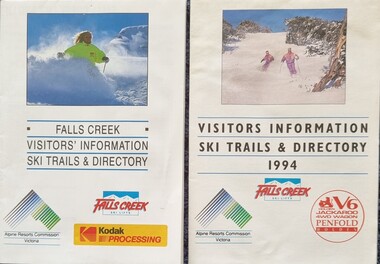
Flyer - Falls Creek Visitors Information 1992 & 1994
... Creek Falls Creek Trail maps Falls Creek Visitor Information Two ...These publications were developed by the Falls Creek Ski Lifts Pty. Ltd. to promote activities and facilities at Falls Creek for the Winter Seasons of 1992 and 1994. They include maps of Falls Creek Village and the surrounding slopes as well as pricing for ski lifts and packages. Advertisements for Frying Pan Inn and Cloud 9 Restaurant are featured.These items are important because they document seasonal activities at Falls Creek Alpine Resort over time.Two glossy coloured flyers featuring images and information about skiing and trails at Falls Creek. Prices for different lift passes, ski gear rental and season passes are included.falls creek marketing, ski packages falls creek, falls creek trail maps, falls creek visitor information -
 Stawell Historical Society Inc
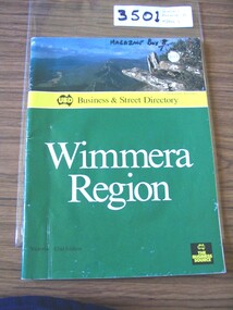
Book, UBD, UBD Business and Street Directory - Wimmera Region, 1992
List of businesses with contact information in the Wimmera Region. as well as maps of Various TownsPaper cover with colour photograph of Boroka Lookout. below a yellow strip with black print and black representation of Australia. below green section with white and black print. black square in lower left with yellow printYellow section, In Map of Australia: UBD Business & Street Directory Green Section: Wimmera Region Victoria 42nd Edition In Black Square: UBD The Business Sourcestawell -
 National Vietnam Veterans Museum (NVVM)
Photograph, Gibbons, Denis, Mekong Delta Operations
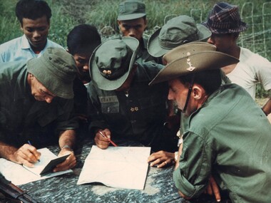
Denis Gibbons (1937 – 2011) Trained with the Australian Army, before travelling to Vietnam in January 1966, Denis stayed with the 1st Australian Task Force in Nui Dat working as a photographer. For almost five years Gibbons toured with nine Australian infantry battalions, posting compelling war images from within many combat zones before being flown out in late November 1970 after sustaining injuries. The images held within the National Vietnam Veterans Museum make up the Gibbons Collection. A colour photograph of two members of the Australian Army Training Team Vietnam (AATTV) operating with the Army Of The Republic Of Vietnam (ARVN), as they check map references and other intelligence information with an ARVN Officer prior to commencing operations in the Mekong Delta of IV Corps.photograph, aattv, mekong delta, army of the republic of north vietnam (arvn), iv corps, gibbons collection catalogue, denis gibbons, photographer, vietnam war, australian army training team vietnam (aattv), intelligence information -
 Falls Creek Historical Society
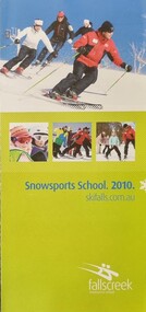
Booklet - Falls Creek Snowsports School Information 2010
Part of yearly marketing and information material promoting the Falls Creek Ski School. This publication includes detailed information about the Falls Creek Snowsport School Program for 2010. An introduction Francis Jackson and the Snowsports team states "Falls Creek Snowsports School is committed to enhancing your skiing and snowboarding experience. Think of our Snowsports School instructors as personal trainers for your snow adventure... they're here ready to elevate you to the next level. With a great attitude, endless patience and always up for fun, our instructors take pride in offering you their very best. From beginner to advanced, whether skiing or boarding, Falls Creek Snowsports School has a program to suit you. Our expert instructors will have you skiing and snowboarding to the best of your ability in no time. Have a great holiday and see you on the slopes!" Corporate Partners in 2010 were Milo, Ten TV and the ANZ Bank.This item is important because it documents seasonal activities at Falls Creek Snowsport School in 2010.A glossy booklet featuring images and information about programs to be offered at Falls Creek in the 2010 winter season. The front cover features a group of downhill skiers and three smaller images. The back cover includes a map showing meeting places, lesson times and contact details.On front cover Snowsport School 2010 skifalls.com.aufalls creek marketing, falls creek snowsport school., francis jackson -
 Bendigo Historical Society Inc.
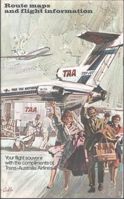
Map - TRANS AUSTRALIAN AIRLINES - ROUTE MAPS, 1950s
... Map. Route maps and flight information for Trans... maps and flight information for Trans Australian Airlines. Fold ...Map. Route maps and flight information for Trans Australian Airlines. Fold out pamphlet includes brief information about major Australian towns and cities.map, flight map, trans australian airlines, taa -
 Bendigo Military Museum
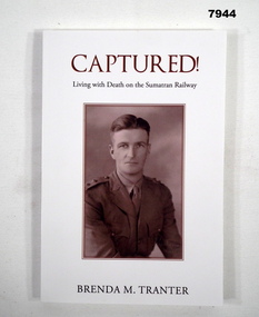
Book - BIOGRAPHY - WW2, Brenda M Tranter, "CAPTURED! LIVING WITH DEATH ON THE SUMATRAN RAILWAY", 2022
'"ARTHUR EDMUND TRANTER" Enlisted on 20/11/1939 Regt No. V50166 in the CMF, posted to 2nd Training Bn Balcombe. Discharged from the CMF 16/12/1940 with the rank of Sergeant in 2/7 Training Battalion. Enlisted in the 2nd AIF 17/12/1940 Regt No. VX52843 in 2/29th Battalion at Darnley Camp, embarked for Singapore 13.9.1941, disembarked 5.10.1941, reported missing 16.2.1942 then classified POW. He was recovered in Sumatra after the surrender. He was hospitalised with Malnutrition then classed Debility. Disembarked Sydney 9.10.1945. Discharged from the 2nd AIF on 20/12/1945 with the rank of Lieutenant. He was awarded a Mention in Despatches and the Efficiency Medal.Soft cover book. Cover - cardboard, white colour background, brown and black colour print on front, spine and back. Front cover illustration - sepia colour, half portrait of "A.E. Tranter". Back cover illustration - colour photograph two wreaths with railway line and sleepers. 168 pages, cut, plain white paper. Illustrated black and white photographs and maps. Attached after page 168 is one A4 sheet of paper, erratum of "Additional Research" information.publications, book, biography, ww2, arthur edmunt tranter -
 Bacchus Marsh & District Historical Society
Map, Allotments in the Village of Rowsley, Parish of Gorrocburkghap, County of Grant c.1856
Rowsley is a locality 11 kilometers south-west of Bacchus Marsh. The date of this map is uncertain. A very similar map held by the State Library of Victoria (SLV) contains slightly more information than this copy and is dated as an 1856 map. SLV reference: 'Allotments in the Village of Rowsley, Parish of Gorrocburkghap, County of Grant', by T. Nixon, Assistant Surveyor, May 1856 ; Surveyor General’s Office, July 18 1856 (lithographed by R. Meikle). (1856). Melbourne: Surveyor General’s Office. MAPS 820 BJE 1837- ROWSLEY 1856. A single page paper map. A cadastral map of the Village of Rowsley in Victoria, showing numbered land allotments. 57 allotments are shown on the map and some areas set aside as reserves. Allotments 8, and 10-16 are outlined in red ink and allotment 9 has a cross in red ink on it. The map is pasted into a bound volume containing 76 maps or plans in total. High resolution digital image stored on BMDHS computer network. rowsley victoria history, rowsley victoria maps -
 Ringwood and District Historical Society
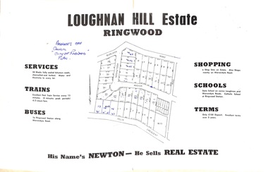
Document - Folder, Subdivision Map - Loughnan Hill Estate, Ringwood, Victoria - circa 1960
Open centre page of land sale brochure glued to manilla folder. Map of residential and shop sites in Burlock Road (later Burlock Avenue), Adolphson Avenue and Felix Crescent, Ringwood, with summary of estate facilities and local services. Agent - T.G. Newton.(Page glued to manilla folder prevents access to front page for further sale information) -
 Melbourne Tram Museum
Book, Metlink, "Information for public transport staff - 2009 Formula 1 Australian Grand Prix", 2008
Forty page full colour publication plus covers with fold out map on the rear cover titled "Information for public transport staff - 2008 Formula 1 Australian Grand Prix". Gives details of event for train, tram and bus crews, event program and transport map, including shunting details, announcements, bus replacement services, electric or automatic points, route alterations. On the back cover has contact telephone numbers and web addresses. 2 copies held.trams, tramways, grand prix, metlink, formula 1, albert park -
 Melbourne Tram Museum
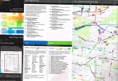
Map, Metlink, "City of Boroondara - Local Travel Guide - July 2008", Jul. 2008
Map, Guide book, Pamphlet, 21 fold, pocket size, titled "City of Boroondara - Local Travel Guide - July 2008" detailing public transport services in the City. Includes map of the tram, train networks, tickets information, tram traction , Connex SMS updates and info on Metlink including contact details. Has a detail map showing services in the city and adjacent overlap area of buses, trams and trains including route numbers. See Reg Item 2283 for Moonee Valley version,trams, tramways, city of boroondara, map, guides, bus services, metlink, connex -
 Melbourne Tram Museum
Ephemera - Tram Route Guides, Metlink, Set of 12 Metlink route maps, c2008?
Set of 12 Metlink route maps, DL, providing a line map with the major stops, roads, approx. times for each section, ticketing zones and on the rear, service frequency and information about Metcards. All the same front styles, but three different styles on rear. Possibly produced before the route maps at Reg item 2443, not dated. Route 3, 5, 6, 8, 16, 19, 57, 59, 64, 67, 72, 78, 79,trams, tramways, metlink, tram services, timetables, route 3, route 5, route 6, route 8, route 16, route 19, route 57, route 59, route 64, route 67, route 72, route 78, route 79 -
 Melbourne Tram Museum
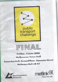
Document - Folder with papers, Metlink, "Public Transport Challenge - Final - Friday 2 June 2006", Jun. 2006
... the Metcard and First Aid. Has a map with checkpoint information... the Metcard and First Aid. Has a map with checkpoint information ...Green plastic binder with a metal clip containing five plastic sheet folders, with notes for "Public Transport Challenge - Final - Friday 2 June 2006", commencing at the Town Hall. Produced by Environment Victoria and Metlink. Contains instructions, how the challenge works, rules, tips, safety, how to use the Metcard and First Aid. Has a map with checkpoint information and questions to be answered while participating.trams, tramways, metlink, public transport, events, competition