Showing 6790 items matching "river"
-
 Eltham District Historical Society Inc
Negative - Photograph, ‘Worlingworth’, Yarra River, Eltham
‘Worlingworth’, Yarra River, Eltham Original homestead on the property ‘Worlingworth’, a large residence and surrounding farm site standing on a knoll above the River Yarra in Banoon Road, Eltham. The present house was built about 1922 and was originally owned by Mr A.R. Read, a stock and station agent and member of the Stock Exchange (who left the district in early 1926 to take up permanent residence at his Warburton property). It became the home of notable anthropologist Prof. Dr. Donald Thomson (1901-1971) and Mrs. Gladys Thomson who were married in 1925 and had twin sons in 1934 and is considered historically and aesthetically significant to the Shire of Nillumbik.This photo forms part of a collection of photographs gathered by the Shire of Eltham for their centenary project book, "Pioneers and Painters: 100 years of the Shire of Eltham" by Alan Marshall (1971). The collection of over 500 images is held in partnership between Eltham District Historical Society and Yarra Plenty Regional Library (Eltham Library) and is now formally known as 'The Shire of Eltham Pioneers Photograph Collection.' It is significant in being the first community sourced collection representing the places and people of the Shire's first one hundred years.Digital image 4 x 5 inch B&W Negshire of eltham pioneers photograph collection, a.r. read, banoon road, donald thomson, eltham, gladys thomson, worlingworth, yarra river -
 Eltham District Historical Society Inc
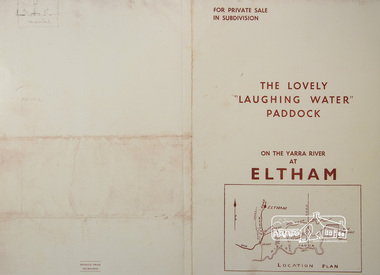
Photograph, For Private Sale in Subdivisions; The Lovely "Laughing Water" Paddock on the Yarra River at Eltham
Private sale of the "Laughing Water" paddock in subdivision; 5 river frontages with weatherboard villa on Lot 8; 6 woodland blocks of 5 and 6 acres. Sole Agent: Edward Haughton, 379 Collins Street, Melbourne Location plan and subdivision mapA3 colour photographic print from digital image of sales brochure and A4 reproduction of price listlaughing waters, edward haughton, real estate agent, eltham -
 Tatura Irrigation & Wartime Camps Museum
Photograph, Pumps on the Goulburn River
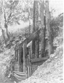
Photo 1. Original suction line entry for water for the pumps on the Goulburn River, south of Murchison. The pumps provided water for the United Echuca Waranga Waterworks Trust Scheme, c. 1880.|Photo 2. Original pump well, still in existance 2003. -
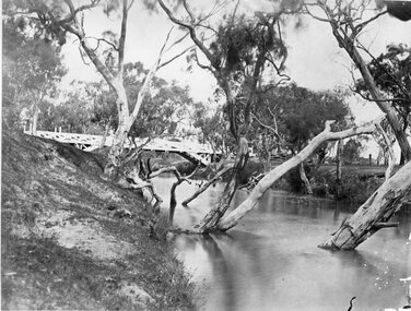
 Greensborough Historical Society
Photograph, Plenty River Bridge Greensborough, 1910c
Early photograph of Main Street bridge over the Plenty River, taken around 1910. Quirk's Tailor shop is seen in the background and a horse and cart coming down the road. The road appears unsealed. Rampant blackberries can be seen growing around the bridge abutments. Part of a collection of photographic enlargements of Greensborough sites.Black and white enlargement of photographic imagemain street bridge, main street greensborough, plenty river greensborough, quirk's tailor shop, blackberry, mckenzie bridge -
 Greensborough Historical Society
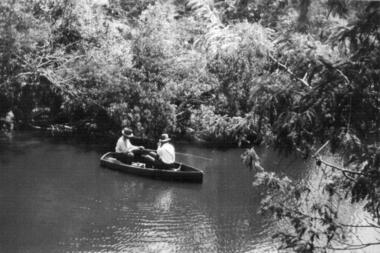
Photograph - Digital image, Two men in fishing boat on the Plenty River in 1937, 1937_
Part of a collection of photographs owned by Dorris McLaughlin who was born in Greensborough, in 1899 to John McLaughlin and Rosalie Ellen Whatmough. The collection contains photographs of friends and relatives from the Greensborough and Eltham areas. This photograph shows two men fishing from a boat on the river.Digital copy of black and white photograph.dorris mclaughlin -
 Greensborough Historical Society
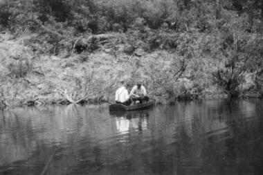
Photograph - Digital image, Two men in a boat fishing on the bank of the Plenty River in 1937, 1937_
Part of a collection of photographs owned by Dorris McLaughlin who was born in Greensborough, in 1899 to John McLaughlin and Rosalie Ellen Whatmough. The collection contains photographs of friends and relatives from the Greensborough and Eltham areas. This photograph shows two men fishing from a boat on a river.Digital copy of black and white photograph.dorris mclaughlin -
 Greensborough Historical Society
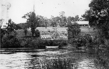
Photograph - Digital image, Outing at Laughing Waters on The Yarra River, 1935, 1935_
Part of a collection of photographs owned by Dorris McLaughlin who was born in Greensborough, in 1899 to John McLaughlin and Rosalie Ellen Whatmough. The collection contains photographs of friends and relatives from the Greensborough and Eltham areas. This photograph shows a large group of people sitting beside the river.Digital copy of black and white photograph.dorris mclaughlin, laughing water -
 Lakes Entrance Historical Society
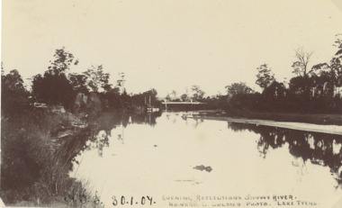
Postcard - Snowy River bridge, H D Bulmer Lake Tyers, Orbost Victoria, 1905 c
Black and white postcard taken of Snowy River with bridge in distance at Orbost VictoriaEvening Reflections Snowy Riverwaterways, bridges, rivers -
 Lakes Entrance Historical Society
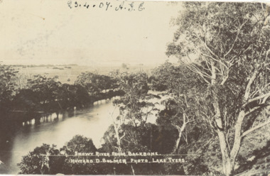
Postcard - Snowy River showing Backbone Point, H D Bulmer, Orbost Victoria, 1905 c
Black and white postcard of Snowy River showing Backbone point Orbost VictoriaSnowy River from Backbonerivers, topography -
 Stawell Historical Society Inc
Photograph, Glenorchy Bridge on the Wimmera River 1866
Glenorchy Bridge Wimmera River. Part of a collection of Photographs by Mr. O.G. Armstrong as commissioned by the Shire of Stawell for the Inter-colonial and Paris Exhibition in Melbourne in 1866. Prior to the construction of this bridge in 1860, there existed two forwards across the Wimmer River at Glenorchy. One was 2 miles on the Stawell side of Glenorchy and 500 metres from the present railway bridge. It was well made, stone floor and can be seen today. The second was located 800 metres downstream of the town and was known as Stuart’s Crossing. These Fords were popular crossing spots for Bullock Drays which were delayed for days during floods before the bridge was built. The original Bridge was built near the site of the present ‘old’ bridge. stawell -
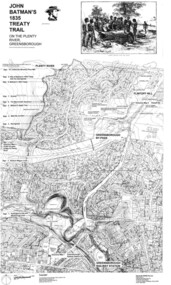 Greensborough Historical Society
Map, Dennis Ward, John Batman's 1835 Treaty Trail on the Plenty River, 2010_
Map of the Plenty River through Greensborough and surrounding areas, annotated with historic places. Prepared by Dennis Ward, this map shows places of interest with historic markers for a proposed Heritage Trail along the Plenty. This was a joint project of Dennis Ward, Rotary Greensborough and Nillumbik Historical Society.This map shows many places of interest along the Plenty River. Large laminated map, including land subdivisions and street names.plenty river heritage trail -
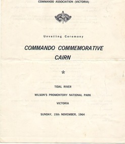 Australian Commando Association - Victoria
Pamphlet, Unknown, Unveiling ceremony Commando Commemorative cairn Tidal River 15 November 1964, 1964
This was the "Order of service" for the inaugural unveiling of the WW2 Commando Cairn at Tidal River, Victoria. Lt General Sir Edmund Herring, Lt Governor of Victoria addressed the assembly, 2 Commando Company soldiers were the Guard of Honour, and the 4/19 PWLH Regt band played. This was the first official memorial to WW2 Commandos, located at Wilsons Promontory where the Commando units were first trained. A memorial ceremony is held in November each year since 1964. Honour rolls of WW2 and post-WW2 Commandos who died in battle or training were added in 2011.2 sheet quarto (four sides) white semi-glossy paper with black type and logo. Order of service.Niltidal river wilsons promontory commando memorial cairn ww2 honour rolls post-ww2 national -
 Port Fairy Historical Society Museum and Archives
Photograph
Aerial view across the Moyne river Black and white photograph of Martins Point, river moyne and the pudney grounds from the air aerial, moyne, river, martin's point, port fairy, barge, dredge, pudney ground, griffith island -
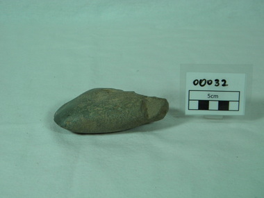
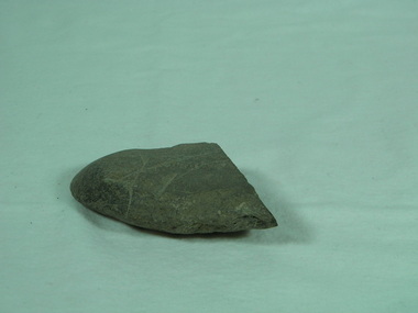 Bright & District Historical Society operating the Bright Museum
Axe Stone
Presence of Aboriginal people and their activities in Buffalo RiverAboriginal axes are relatively uncommon in North East Victoria and provide evidence of presence and exploitation of resourcesground edge stone axe with some edge damage and edge polish on working edge and flat opposite edge. axe, aboriginal artefact, buffalo river -
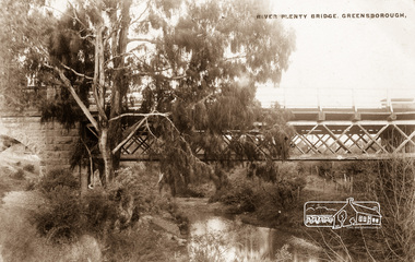 Eltham District Historical Society Inc
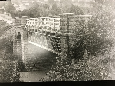
Photograph postcard, River Plenty Bridge, Greensborough
Postcard with view of bluestone bridge over the Plenty River on what is now Main Street, Greensborough. Built in 1860 by a Scottish stonemason, James Neave McKenzie. Most of the bridge was demolished in 1966 with the remaining bluestone arch preserved till 1983 when it was also demolished. This view about 1900.Digital file only Postcards scanned from the collection of Michael Aitken on loan to EDHS, 13 Feb 2018michael aitken collection, postcards, greensborough, plenty river bridge, plenty river -
 Wodonga & District Historical Society Inc
Album - Ringer's River by Des Martin - Plate 4 - O'Day's appointment announced
Back at the station MacLough announces to the assembled men that O'Day is now manager of Gooloora, with absolute power to hire, fire, buy, or sell, until he personally decides otherwise. He then has O'Day drive him to Overton where he repeats this to the bank manager, and arranges ample credit for the 20 year old executive before catching his train to the city.The album and images are significant because they document literature written by a prominent member of the Wodonga community. The presentation of this precis was supported by several significant district families and individuals.Ringer's River Album Coloured photo Plate 4 Back at the station MacLough announces to the assembled men that O'Day is now manager of Gooloora, with absolute power to hire, fire, buy, or sell, until he personally decides otherwise. He then has O'Day drive him to Overton where he repeats this to the bank manager, and arranges ample credit for the 20 year old executive before catching his train to the city.des martin, many a mile, ringer's river, northeast victoria stories -
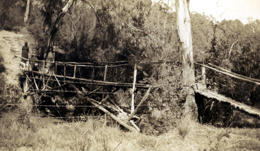 Greensborough Historical Society
Photograph - Digital image, Rose McLaughlin and others - bridge over Plenty River 1935, 1935_
Rose McLaughlin, Frank Oxley (Cousin of John McLaughlin) Myrtle McLaughlin - Bridge over Plenty River 1935. John McLaughlin and Rosalie Ellen Whatmough came to Greensborough in 1840 from Belfast. These photographs from the collection of Myrtle McLaughlin show friends and relatives from the Greensborough and Plenty area.This photograph shows some of the primitive conditions in the area.Digital copy of black and white photograph.myrtle mclaughlin, rosalie mclaughlin, frank oxley -
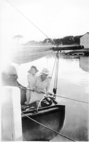 Port Fairy Historical Society Museum and Archives
Photograph
Moyne River Scene January 1944 Subjects unknownBlack and white photograph of Two ladies at stern of boat fishingmoyne river, fishing, port fairy, boat -
 Bendigo Military Museum
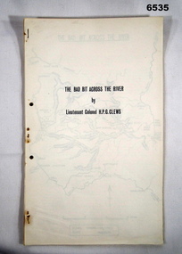
Journal - Royal Australian Survey Corps - The Bad Bit Across the River - LtCol HPG Clews 1934, LTCol HPG Clews RASvy, 1934
This Journal "The bad bit across the River" was written by - LtCol HPG Clews in 1934 and is about his experiences around the Colo River approximately 60 miles NW of Sydney, NSW. LtCol Clews was a remarkable man and his achievements were just as remarkable. He is affectionately known as "The Major." He served in the British Army 1909 - 1911 with the Sherwood Foresters. He then served in the Royal Australian Survey Corps from 1912 - 1949 and then served as the Senior Surveyor with the Snowy Mountains Authority from 1950-1958. A Survey Cairn is errected in Khancoban to record his life 1890 - 1980. This Journal records the field trip to establish Survey Control in very rugged country by a handful of party members on foot. The map shows the routes taken.14 x foolscap pages stapled and two hole punched. The Journal includes a map, 7 x pages of typed text and 4 x Annexesroyal australian survey corps, rasvy, fortuna, army survey regiment, army svy regt, asr, 2nd field survey company -
 Orbost & District Historical Society
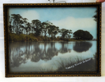
photograph, 1937
The photo was probably taken by Will Herbert and used at the 1937 "Back to Orbost" celebrations. The photo depicts the Snowy River at Orbost when it was at a high level.A coloured photograph in a brown wooden frame which has gold painted decorated edges. A wire hanger is attached. The photo shows reflections of trees along the bank of the Snowy River in 1937.On bottom right of photo - Snowy River Orbost On back of frame - Back to Orbost 1937 from Will Herbertphotography snowy-river orbost-1937 -
 Phillip Island and District Historical Society Inc.
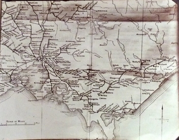
Photograph, Rail Lines of Victoria, Early to mid 20th century
Map showing extensive railway network in Victoria in early C20th.Sepia photo of map of Victoria showing rivers and railway lines and stations.Names of towns, rivers, bays etcsepia photograph, rail transport, victoria, map -
 Orbost & District Historical Society
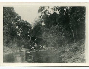
black and white photograph, C1890
This snagging team is on the Brodribb River, east of Orbost. The Brodribb bridge can be seen in the background of the Photograph. The Snowy River was used for commercial navigation after 1880 and extensive de-snagging A shipping company was formed in 1880, poling barges upstream until the removal of large trees and branches that had fallen into the river was carried out to make the river upstream of Marlo easier to navigate. "The snaggers played an important part in making the river free for transport. By 1880 Captain Collins, R McNair engineer, J McNair and the two Winchesters were at work with a punt on the Snowy and Brodribb. Mr. Jim Winchester took charge soon after. Early snaggers were Johnston, J Renton, Nat Lynch, John Drew, Hatton, J Scott and Harry Wilkinson. The system used was to use a tree on the river bank as a lever and with heavy manila ropes, slowly to haul the snags out. They were piled up around a tree and burned when dry. The snaggers lived in a row of cottages in Snaggers’ Lane." (info. John Phillips Newsletter March 2004)The snaggers played an important role in the early settlement of the Orbost / Marlo district helping bto open it up to commercial shipping.Two copies of a black / white photograph of nine men on a snagging boat, a flat-bottom barge. In the background is a bridge.on back - "Snagging boat on Brodribb with R.McNair"snaggers-brodribb-river snagging-east-gippsland transportation -
 Greensborough Historical Society
Map, Heidelberg. Historic River Landscape Assessment. Historical maps: Map C 1851-1863. "The Garden of the colony", 1985c
Geographical area of around 35 sq. kilometres marked with physical features such as major roads, vegetation and properties, with locations and notes of the increasing number of farms, gardens orchards and vineyards which had become established in addition to pastoral runs. Bounded by Shire of Diamond Valley to the North, Darebin Creek to the West and Plenty River to the East.Black and white sketch map on white paperheidelberg, heidelberg - maps -
 Orbost & District Historical Society
black and white photographs, August 21 1987
These photographs are of the final train to leave Orbost railway Station on August 21 1987 signalling the closure of the line. 3105.12 shows Locomotive T408 and on the side is written "LAST TRAIN EX ORBOST 24.8.87". These photographs are associated with the history of the Orbost-Bairnsdale railway line and therefore reflects the role that the rail line played in the social and economic history of Orbost. The closure of the line was a significant event in Orbost's history.Fifteen black / white photographs of the last train to leave Orbost Railway station.3105.1 - on back - "Last Train leaving Orbost Railway Station on Friday August 21. 1987. SRM August 26 1987 Last train from Orbost, Friday last saw the end of an era when the last freight train to pull out of Orbost Station at about 4.co pm. A symbolic wave from engineer, Bill Buckley, was the only ceremony to mark the passing of rail transport for East Gippsland." 3105.2 - on back - " Last train prepares to leave from Orbost on August 21, 1987." 3105.3 - on back - " The Orbost railhead following the departure of the last train on Friday August 21, 1987. Shows spectators who farewelled the last train." 3105.4 - on back - "From Grandview, Newmerella, shows the last train from Orbost crossing the timber Trestle (sic) viaduct across the Snowy River flats on Friday August 21, 1987" 3105.5 - on back - " A pair of Series 3 "T" Class Diesel Electric locomotives which were used to haul the final train from the Orbost Rail Head on Friday, August 21, 1987. Goods shed on right" 3105.6 - on back - " VFTY Timber Wagons at the Orbost Railway Station. 30 of these large wagons were built for the timber traffic between Orbost and Melbourne. Part of last train to leave Orbost on August 1, 1987." 3105.7 - on back - "The Fordson powered Rail Tractor which was used during shunting at the Orbost railway station, hooked up behind the second locomotive for its final journal from Orbost on Friday August 21, 1987." 3105.8 - on back - "Two Series 3 "T" Class Locomotives (Diesel Electric) were used to haul the final train from Orbost - T408 and T347, T408 was the leading locomotive. Orbost Goods Shed is on the left. Last train left on Friday August 27, 1987." 3105.9 - on back - " 3 "T" Class Diesel Electric locomotives often used in pairs to haul the timber trains out of Orbost. This locomotive was used to lead (haul) the final train from Orbost on Friday August 21, 1987" 3105.10 - on back - "The Gantry at the Orbost Railway Yards - capacity 10 tons. The last wagons before being hooked up to the locos for their last trip out of Orbost on Friday August 21, 1987" 3105.11 - on back - " Station Masters Office and Goods Shed at Orbost Railway Station. The two Series 3 "T" Class Diesel Electric locomotives waiting to haul the final train from Orbost on Friday 21 1987" otrbost-bairnsdale-railway east-gippsland-railway orbosr-railway-closure -
 Kew Historical Society Inc
Photograph - Submerged houses in River Avenue, North Kew, 1934
North Kew, now divided between Kew and Kew East, bordered the Yarra River. As such, it was a region subject to flooding in the Yarra Valley. Development beyond this point (ie Kellett Grove) was limited by the City of Kew's planning regulations. Prior to urban development, the area since European settlement and the first land sales in the district in the 1840s, had been used for dairy farming. Vivid photograph contrasting domestic life and relationships with natural disasters such as the flood of 1934.Small sepia snapshot of two submerged houses belonging to local families in River Avenue, North Kew, during the 1934 floods. The view is presumably from near Kellett Grove looking north towards Fairfield.Verso: COES & HYATTS ROOF / RIVER AVENUE / Stamped: 6414yarra river -- north kew, floods -- yarra valley, floods -- north kew, floods -- 1934, natural disasters -- kew -
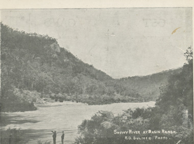 Lakes Entrance Historical Society
Postcard - Snowy River at Basin Ranch, Bulmer, 1930 c
Black and white postcard of Snowy River at Basin Ranch with two men in foreground pointing to high cliff across the river Gippsland VictoriaSnowy River at Basin Ranch H D Bulmer photowaterways, topography -
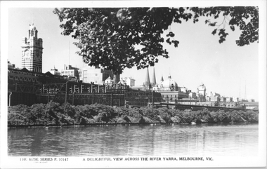 Melbourne Tram Museum
Postcard, Rose Stereograph Co, "A delightful view across the River Yarra, Melbourne"
Rose Series postcard No. P 10147, titled "A delightful view across the River Yarra, Melbourne" showing a view from the south bank of the Yarra across to Flinders St station, the signal gantries at the west end of the platforms, the station buildings and some of the other buildings on the skyline. A St Kilda bound dog box (swing door) set is in platform 10 awaiting departure.Yields information Flinders St station from the south side of the river.Postcard - printed real photograph with Rose Stereograph Co. name on the rear.flinders st station, signals, yarra river, railways, electric trains -
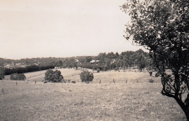 Greensborough Historical Society
Photograph - Digital Image, Cherel Sartori, Looking east from Henry Street to the river 1956, 01/01/1956
Looking from Henry Street east to the Plenty River, 1956. The house was built 1917, at 112 Henry Street Greensborough by William Mitchell on the 60 acre dairy farm owned by Ethel and Walter Kell. This collection of photographs was copied by Cherel Sartori (who owned the house from 1990-2000), following a visit by Claude Amiet who lived in the house as a child in the early 20th century.An indication of the rural aspect of this area in the mid-20th century.Digital copy of black and white photographkell's cottage, claude amiet, cherel sartori -
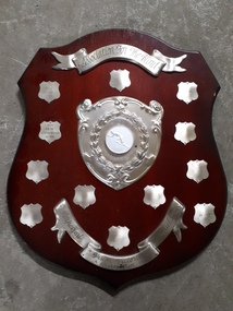 Vision Australia
Photograph - Image, Lifetime, Association for the Blind : Vision Victoria River Run Perpetual Shield
A brown wooden award with a banner engraved 'Association for the Blind' at the top of the shield, a large metal plate with a laurel wreaths and relief of a man starting to run in the middle. At the base is another banner inscribed 'Perpetual Shield Vision Victoria River Run'. 12 smaller shields frame the central plate, with names on two of them: 1990 Mike Hillardt 31.39 and 1991 Amon O'Callaghan 31.49. Wooden shield with 12 mini shields, banner and image of runner in centreassociation for the blind, mike hillardt, amon o'callaghan -
 Bright & District Historical Society operating the Bright Museum
Axe Stone
Evidence of Aboriginal presence and activities in Buffalo River Valley near site of present Buffalo Dam.Evidence of Aboriginal presence and activities in North East and Alpine areas relatively uncommon.quartzite ground edge stone axe with edge damage axe, aboriginal artefact, buffalo river