Showing 1808 items
matching subdivision
-
 Tatura Irrigation & Wartime Camps Museum
Certificate of Title, Subdivisions, 1879 and 1930
Title Deeds for property in Tatura2 certificates of title showing subdivisions made over several years. Vol. 5655:Folio 1130935 dated 16/5/1930 and Vol.1182: Folio 236330 dated 23/12/1869. Lease between Thomas Hogan and W F Bazeley dated 7th July 1911 for land in Hogan Street known as Slaughter Yard Paddock .Also lease dated 1911. In buff coloured legal envelope with number "2678" and "Hogan - Thomas" written in red on outside.tatura, relationship folders, certificate of title, lease, thomas hogan, john hogan, john james hanlon, edward glover, arthur burke, james brady, andrew collie, jean hunter, sydney embling, john maher, arthur goyen, patrick o'toole, philipe dove, george wildon, edwin harden, cuthbert corke, lee chung, hugh barnes, george manning, francis williams, john fawkner, michael walshe, alexander ferguson, rose gullett, john gibb, william taylor, richard casey, anthony grover, arthur grover, charles brady, elizabeth davey, frank williams, honora culkin, alexander park, stephen reville, richard carr, charles grover, henry mccarthy, james bruce, edward hanley, chew yen, ah poy, loo way, ah dick, charles mitchell, lionel martin, douglas forsyth, catherine wilson, mabel heath, patrick mcnamara, micheal cussen, james wilson, bazeley, documents, legal -
 Ringwood and District Historical Society
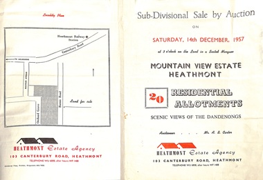
Flyer - Land Sales Brochure, Sub-Divisional Sale by Auction - Mountain View Estate, Heathmont, Victoria - 1957
Bi-fold pamphlet advertising auction of 20 residential allotments on Saturday, 14th December, 1957, with description of services available and finance terms. Subdivision inclues Orchard Grove and Barnic Road. Agent - Heathmont Estate Agency, 103 Canterbury Road, Heathmont, Telephone WU6808, after hours WF1488. Auctioneer Mr. A.B. Carter. Accompanying Parish of Ringwood survey map with cardboard backing - Part of Crown Allotment 14B, includes handwritten price notations for each allotment. -
Glen Eira Historical Society
Document - Lempriere Avenue, 10, St. Kilda East
A brief history of the property at 10 Lempriere Avenue, St. Kilda East, built on a subdivision of the land of William George Lempriere. Includes some information on the Lempriere Family and public park, Greenmeadows Gardens. The document by Rosalind Landells, David Bick and Hilary Bullock of the Brighton Historical Society is dated October 30, 1995. Includes handwritten notes covering mostly same information. Includes bibliography.greenmeadows, lempriere william george, clarke william senior, lempriere john thomson, zimmerman a.k., nelson frank l., greenmeadows gardens, lempriere avenue, nelson m.d., st. kilda east, parks and reserves, zucker a.a., greenmeadows lane, lempriere family, lempriere’s paddock, councillors -
Glen Eira Historical Society
Document - Bertram Street, 37, Elsternwick
A one page copy of correspondence dated 22/04/1988 concerning Bertram Street, 37, Elsternwick, the Gardenvale Railway Station and land sales in the area. Researched by the Brighton Historical Society. The file also includes a one page handwritten excerpt from the publication Sand, Swamp and Heath by Murray and Wells, about the subdivision named Gardenvale and the occupiers of Bertram Street, 37, Elsternwick.bertram street, elsternwick, prowse reginald, watson george j, gardenvale, parnell street, muntz street, muntz edwin parnell, muntz thomas b, surveyors, engineers, gardenvale station, market gardens, small and edwards, land developers, gardenvale on the hill, bullock h, landells rosalind -
 Halls Gap & Grampians Historical Society
Photograph - B/W, 14/04/1931
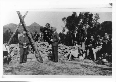
The photo shows the opening ceremony of Henham Township by Lord Stradbroke (the man on the right of the structure). A strip of land 2 kilometres long and half a kilometre wide had been approved as suitable for subdivision into 591 quarter acre blocks valued at 30-35 pounds each. Unfortunately it turned out to be a "fizzer". For further information see Victoria's Wonderland pp 93-95, 103.Photo shows a group of people sitting on and standing behind a low pile of rocks that sweeps around a wooden structure, which is three rough logs standing and lashed together to form a rough pyramid. A pulley is attached to the apex of the pyramid and a large stone block is suspended from it. Two men stand, one in front of and one beside the structure, both wear suits and are holding pieces of paper. A young boy sits in the left foreground in front of one of the poles.events, ceremonies -
 Halls Gap & Grampians Historical Society
Photograph - B/W, 14/04/1931
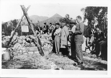
The photo shows the opening ceremony of Henham Township by Lord Stradbroke (the man on the right of the structure). A strip of land 2 kilometres long and half a kilometre wide had been approved as suitable for subdivision into 591 quarter acre blocks valued at 30-35 pounds each. Unfortunately it turned out to be a "fizzer". For further information see Victoria's Wonderland pp 93-95, 103.`Photo shows five men, middle foreground all standing, with others seated and standing in the background. The man stranding closest to the camera is holding a piece of paper in his hand. A rock pile and low stone fence can be seen middle foreground. A pulley is attached to a tripod of tree posts and is holding up a large cut stone. Mountains are visible in the background.events, ceremonies -
 Kew Historical Society Inc
Plan - Subdivision Plan, Central Park Estate, Deepdene - Camberwell, 1923
The Kew Historical Society collection includes almost 100 subdivision plans pertaining to suburbs of the City of Melbourne. Most of these are of Kew, Kew East or Studley Park, although a smaller number are plans of Camberwell, Deepdene, Balwyn and Hawthorn. It is believed that the majority of the plans were gifted to the Society by persons connected with the real estate firm - J. R. Mathers and McMillan, 136 Cotham Road, Kew. The Plans in the collection are rarely in pristine form, being working plans on which the agent would write notes and record lots sold and the prices of these. The subdivision plans are historically significant examples of the growth of urban Melbourne from the beginning of the 20th Century up until the 1980s. A number of the plans are double-sided and often include a photograph on the reverse. A number of the latter are by noted photographers such as J.E. Barnes.An agent’s board on which parts of an advertisement for the Central Park Estate have been pasted. [The State Library of Victoria holds a complete plan]. Whereas the original plan included black and white photographs and effusive prose about the virtues of the Estate, the item in our collection includes only the actual blocks. The agent has annotated particular blocks to indicate that they have been sold.subdivision plans - deepdene - camberwell, central park estate -
 Ringwood and District Historical Society
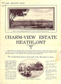
Flyer, Land Sale Brochure, Charm-View Estate, Heathmont, Vic. - c1926
Double sided folded page advertisement highlighting local facilities, services and layout of blocks for sale in Charm-View Estate.Subdivision includes Heathmont Road, Orchid Street, Bennett Avenue, Dickasons Road and Canterbury Road. (Agents) T. Burkitt & Co., Phone Ringwood 157, Overton & Co., 390 Chapel Street South Yarra, Phone Windsor 542. Solicitor A.V. Wischer, 443 Chancery Lane, Melbourne. -
Warrnambool and District Historical Society Inc.
Document (item) - Allansford land purchase document, Land purchase document, 1864
This paper contains details of the purchase of Lot 11 in the Township of Allansford in 1864. The purchaser, Isabella McQueen, was born in Scotland in 1814, married Alexander McQueen in 1850 and with her family migrated to Australia in 1854. After her husband's death in 1860 Isabella purchased the land in Frank Street, Allansford in 1864 and lived in a house there with family members until her death in 1895. She had purchased the land, via an agent, from John Allan who with his brothers were the pioneer European settlers in the Allansford area. John Allan had created the township of Allansford in the mid 1850s by sub-dividing the land he owned there. John Allan moved to the Gippsland area late in 1864. This piece of paper is most significant as it is an original record of an early transaction in the history of Allansford, a town now part of Warrnambool City.Mrs isabella McQueen Bot. of Robert Gregory As agent for J M Allan Esq. Lot no. 11 as marked and described on the Plan of Subdivision of the Township of Allansford. For which I have received the um of five pounds Stg. being the purchase money of same. Robert Gregory 21st October 1864allansford history, john allan, isabella mcqueen -
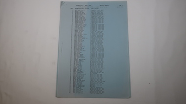 Kiewa Valley Historical Society
Papers - Mt Beauty Voters' Roll, Shire of Bright - Voters' Roll 1985 - Mt Beauty, 4th July 1985
Electoral rolls list people who are registered and eligible to vote at federal, state, territory and local government elections and referenda. Prior to 1990 the rolls list voters in alphabetical order by surnames and first names within each Subdivision of an electoral division of each State or Territory. The roll is useful & interesting for family historians and the study of demographics. Alex McCullough lived in Mt Beauty and was a councillor for the Shire of Bright.Electoral Rolls help to locate the residential address of a person in a particular year or over a period of years. They can be used as a substitute for census records for family historians and the history of a particular place - in this case Mt Beauty.9 pages of firm blue paper with black typed print on one side only. Held at the top left corner with one staple. Each page has columns with 100 people listed up to 864 on page 9. surnames are in alphabetical order followed by given names and then addresses.shire of bright; voters' roll; alex mccullough; mt beauty -
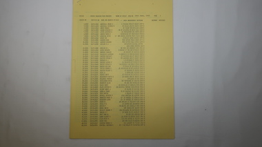 Kiewa Valley Historical Society
Papers - Kiewa Riding Voters' Roll, Shire of Bright - Voters'Rolls 1985 (May and June) - Kiewa Riding, 4th July 1985
Electoral rolls list people who are registered & eligible to vote at federal, state, territory & local government elections & referenda. Prior to 1990 the rolls list voters in alphabetical order by surname & first names within each subdivision of an electoral division of each state or territory. The roll is useful and interesting for family historians & the study of demographics. Alex McCullough lived in Mt Beauty and was a councillor for the Shire of Bright.Electoral Rolls help to locate the residential address of a person in a particular year or over a period of years. They can be used as a substitute for census records for family historians and the history of a particular place - in this case Tawonga, Tawonga South, Falls CreekMay 1985 is 7 pages; June 1985 is 9 pages of firm yellow paper with black typed print on one side only. Held by one staple at the top left hand corner. The May 1985 - Each page has columns with 100 people listed up to 628 on page 7. Surnames are in alphabetical order followed by given names and then address. June 1985 Voters Roll (Non resident) is created from Property & lists Voters No. (up to 406) Property No. Name (alphabetical) & address and are non resident voters.shire of bright; voters' rolls; kiewa riding; tawonga; tawonga south; alex mccullough; falls creek -
 Surrey Hills Historical Society Collection
Book, Medlow Garden Survey and Landscape capability study 1983, Oct-83
Includes: Plan of Subdivision, Detailed plan, map of garden, Auctioneer's plan for 1854 sale, Botanical plan of Medlow & Landscape history notes. Full title : Medlow Garden survey and landscape capability survey. A report for the National Trust of Australia (Victoria) A report giving a detailed landscape survey of Medlow Garden estate. Includes landscape story, cultural significance, particulars about vegetarian, garden, rehabilitation and plans.Copy of a report giving a detailed landscape survey of Medlow Garden estate. Includes landscape story, cultural significance, particulars about vegetarian, garden, rehabilitation and plans. 38 pages with illustrations.land surveys, medlow garden, bismark estate, rosalie estate, warrigal road, surrey hills, bismarck avenue, warwick avenue, t p payne, (mr) hugh glass, boroondara, (mr) (maj) - cairncross, (mrs) mary jane cairncross, (dr) (mr) richard joseph bull, (mrs) catherine grace bull, (miss) norma bull, (mr) ronald richard bull, medlow -
 Surrey Hills Historical Society Collection
Book, Medlow Garden Survey and Landscape capability study 1983, Oct-83
Includes: Plan of Subdivision, Detailed plan, map of garden, Auctioneer's plan for 1854 sale, Botanical plan of Medlow & Landscape history notes. Full title : Medlow Garden survey and landscape capability survey. A report for the National Trust of Australia (Victoria) A report detailing the landscape survey of Medlow Garden estate. Includes landscape history, cultural significance, particulars about vegetarian, garden, rehabilitation and plans.A report detailing the landscape survey of Medlow Garden estate. Includes landscape history, cultural significance, particulars about vegetarian, garden, rehabilitation and plans. 38 p illland surveys, medlow garden, bismark estate, rosalie estate, warrigal road, surrey hills, bismarck avenue, warwick avenue, t p payne, (mr) hugh glass, boroondara, (maj.) (mr) - cairncross, (mrs) mary jane cairncross, (dr)(mr) richard joseph bull, (mrs) catherine grace bull, (miss) norma bull, (mr) ronald richard bull, medlow, house names, (mr) rex swanson, landform australia -
 City of Kingston
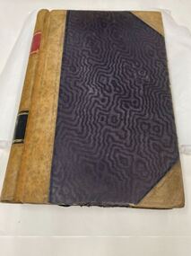
Book - Rates Cash Book, Rates Cash Book Moorabbin Shire, 1919, 1916
Councils use property values to calculate how much each property owner pays in rates. This can give us some insight to property values within the municipalities. Receipts have been recorded by Receipt No, Date, Name and Riding. The subdivisions at that time which were proclaimed by Order-in-Council on 22nd May 1917, were North Riding, Moorabbin Riding, Cheltenham Riding, and South Riding.Brown suede and Black linen bound book with Rates Cash Book Moorabbin Shire in gold text along the spinePrinted on white rectangular sticker in black ink: ARNALL & JACKSON/ Engravers and Lithographers/ PRINTERS/ and/ MANUFACTURING STATIONERS/ 478 Collins Street/ MELBOURNE/ No.B 27676 / 1/8/19rates, ridings, moorabbin, municipality -
 City of Kingston
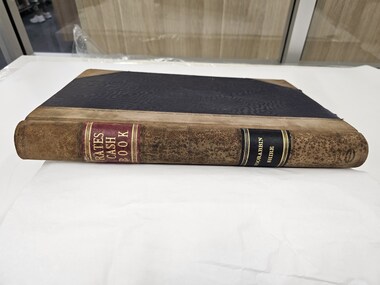
Book - Rates Cash Book, Rates Cash Book Moorabbin Shire, c.1918
Councils use property values to calculate how much each property owner pays in rates. This can give us some insight to property values within the municipalities. Receipts have been recorded by Receipt No, Date, Name and Riding. The subdivisions at that time which which were proclaimed by Order-in-Council on 22nd May 1917, were North Riding, Moorabbin Riding, Cheltenham Riding, and South Riding.Brown suede and Black linen bound book with Rates Cash Book Moorabbin Shire in gold text along the spinePrinted on white rectangular sticker in black ink: ARNALL & JACKSON/ Engravers and Lithographers/ PRINTERS/ and/ MANUFACTURING STATIONERS/ 478 Collins Street/ MELBOURNE/ No.B 33325 / 2/10/18 rates, ridings, moorabbin, municipality -
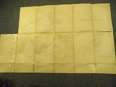 Yarra Glen & District Historical Society
Map, Plan of Yarra Glen Water Area
The map has been used by water supply officers to map the supply of water to properties in the township area of Yarra Glen.The item is significant because it records changes to the supply of water to Yarra Glen over a period of approximately 100 years. It also records property owners and subdivisions.Flat map which folds into 12 pages with a dark red cloth cover. One page in top left corner is missing. Scale of the map is 300 feet to an inch. Cream coloured packing tape has been placed along the back of the folds and is now peeling off.Round stamp in top right corner "Shire of Eltham". Pencil note on top left existing page "Note - includes record of 8 LP's subdivisions. HC". Information has been added to the map over an extended period of time in red ink, black pencil, blue pencil and blue biro.yarra glen/water supply/ -
 Surrey Hills Historical Society Collection
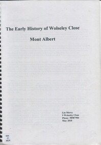
Book, The early history of Wolseley Close, Mont Albert, 2010
Includes copy of will of William Clark. Resident of the property at 9 Wolseley Close in 1910. Includes copy of the Alan Holts home occupier / tenant records - names from 1920 - 1980. Includes photo of Wolseley Close house, taken 1888/1889 plus colour photo of Wolseley Close house taken by Lin Merry, 2010. Land Title information, surveys, subdivision Includes list of occupants of the house, p.17Includes some plans of houses built in Wolseley Close, Mont Albert, Victoria. Outlines details of property at 9 Wolseley Close19p : col illcragg family, windsor crescent, surrey hills, (mr) william ainger, (mr) isaiah ainger, whitehorse road, noorn hill, house names, koonda, d j maloney, (mrs) louisa clara maggs, taramera, union road, st.abbs, york street, (mr) william henry cleverdon, wolseley street, windsor park estate, tarawera, merry family, clinton family, adams family, tel-el-kebir, farrell family, (mr) william clark, trafalgar street, (mr) (sir) matthew davies, (mr) c h james, (mr) james munro, (mrs) elizabeth clark, langdale, (mr) stanley dewar, (mr) john jose, (mrs) emily hampton, potton, (mr) alexander potton, (mr) john atkinson morris, freehold investment & banking co., mont albert, windsor park surrey hills, dalton family, (mr) henry wood, wolseley close -
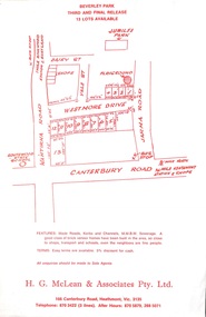 Ringwood and District Historical Society
Flyer, Land Sale Advertisement, Beverley Park, Heathmont - circa late 1970s
Single sided leaflet with red printSubdivision includes Wantirna Road, Daisy Street, Vale Street, Westmore Drive, Jarma Road, Canterbury Road. Sole Agents - H.G. McLean & Associates Pty. Ltd. 166 Canterbury Rioad, Heathmont, Vic. 3135 Telephone 870 3422 (3 lines) After Hours 870 5879, 288 5071 -
 Warrnambool and District Historical Society Inc.
Book, Road register loose binder, 1953
This is an Alphabetical Register of the streets in Warrnambool as listed by Warrnambool City Council officers. It appears to have been a working register used in the 1950s, 60s and 70s and information has been added to the entries as it became available and as Council works were carried out in these streets. It contains information on the locality, wards, allotment numbers, lodged plan numbers, footpaths and printed information from the Victorian Local Government Departments. It sometimes gives the origin of the name of the street and some other miscellaneous information is included. It is presumed that the information contained therein has now been stored electronically. This is a most important ledger as it contains much valuable historical information on Warrnambool streets. It will be of great use to researchers. This is a loose leaf binder with a black leather cover and a black metal and cord binding mechanism. The pages are unnumbered but there is provision for insertion or removal of pages and there are leather alphabetical tabs protruding from the pages. The pages have blue ruled lines with blue lined margins and headings. The streets in Warrnambool are listed alphabetically and the information in the register contains both typed and handwritten material. There are also printed notices from the Victorian Local Government department, extracts from newspapers, copies of letters and plans of street subdivisions. There is one loose page.warrnambool city council, warrnmbool streets register -
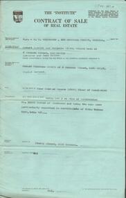
 Bendigo Historical Society Inc.
Document - H.A. & S.R. WILKINSON COLLECTION: CONTRACT OF SALE
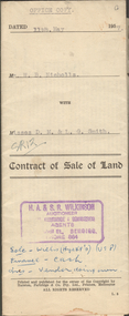
Contract of sale of land dated 11th May, 1957 between Mr. W.B. Nicholls (seller) and Misses D.M. & L.G. Smith. For land being lot 8 on vendor's plan of subdivision by Mr. Surveyor Pritchard, dated 2nd May, 1957 having a frontage of 59 feet to Alamein Court by a depth of 100 feet, being part allotment 7 section 31A land described in Crown grant volume 8113 folio 731. Subject to any registered appurtenant easements. Price 3,600 pounds.organization, business, h.a. & s.r wilkinson real estate -
 Bendigo Historical Society Inc.
Document - H.A. & S.R. WILKINSON COLLECTION: CONTRACT OF SALE
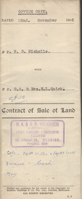
Contract of sale of land dated 22nd November, 1956 between Mr. W.N. Nicholls (seller) and Mr. G.A. & Mrs. M.L. Quirk (buyers) for piece of land being lot 17 of plan of subdivision No. 33303 lodged in the office of titles being part of Crown allotment 16 section 7A, Kangaroo Flat and situate corner Camp and carpenter Streets, Kangaroo Flat, together with brick veneer dwelling and all sundry, also all electric light fittings and shades. Price 4,500 pounds.organization, business, h.a. & s.r wilkinson real estate -
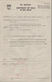
 Bendigo Historical Society Inc.
Document - H.A. & S.R. WILKINSON COLLECTION: CONDITION OF SALE
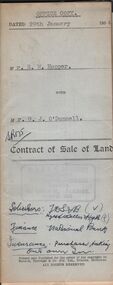
Contract of sale of land dated 29th January 1954 between Mr. E.M. Hopper (seller) and Mr. G.J. O'Donnell (buyer) for land being Lot 2 on plan of subdivision No. 23332 registered in the office of titles, Melbourne and situate in Lindsay Street Kangaroo Flat part of Crown allotment 11 section 23, township of Kangaroo Falt described in Certificate of title volume 7446 folio 423, together with weatherboard dwelling, wood shed-lavatory also fencing on the said land. Price 2,700 pounds.organization, business, h.a. & s.r wilkinson real estate -
 Bendigo Historical Society Inc.
Document - H.A & S.R. WILKINSON COLLECTION: CONDITION OF SALE
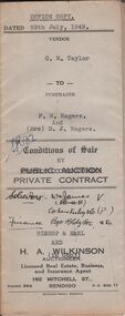
Conditions of sale by private contract issued by Bishop & Earl and H.A. Wilkinson and dated 25th July, 1949 between C.M. Taylor(seller) and F.W. Rogers + D.J. Rogers (buyers) land situate No. 47 Reginald Street Bendigo at present occupied by the purchaser as tenant, being part of Crown allotment 23 section 104C described in Crown grant volume 2052 folio 410334 as per plan of subdivision approved by the Bendigo Council, together with 4-roomed weatherboard dwelling and all sundry. Price 1,100 poundsorganization, business, h.a. & s.r wilkinson real estate -
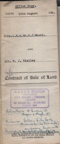 Bendigo Historical Society Inc.
Document - H.A. & S.R. WILKINSON COLLECTION: CONDITION OF SALE
Contract of sale of land issued by H.A. Wilkinson and dated 15th August, 1952 between Mrs. L.M. & Mr. K. J. Monti (sellers) and Mr. W.J. Rielley for land being Lot 3 on plan of subdivision lodged in the office of titles in red ink No. 5062838 and being part of Crown allotment 20A section 16, City of Bendigo, Parish of Sandhurst, County of Bendigo and situate in Napoleon Crescent, White Hills, together with 6-roomed weatherboard dwelling and all sundry. Price 2,850 pounds.organization, business, h.a. & s.r wilkinson real estate -
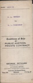 Bendigo Historical Society Inc.
Document - H.A. & S.R. WILKINSON COLLECTION: CONDITION OF SALE
Conditions of sale by private contract dated 20th April 1925 between G. A. Pethard as seller and H. A. Wilkinson as buyer. Contract issued by George Pethard Auctioneer for sale of land situate in Elizabeth Street Nyah West being lot 100 on plan of subdivision No. 6415 lodged in the office of titles and being part of Crown Allotment 11 Parish of TynTynder West County of Tatchera described in certificate of title volume 4642 Folio 928297, together with 4-roomed weatherboard dwelling. Price 518 pounds.organization, business, h.a. & s.r wilkinson real estate -
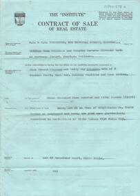
 Bendigo Historical Society Inc.
Document - H. A. & S. R. WILKINSON COLLECTION: CONTRACT OF SALE
Contract of sale of real estate dated 15th April, 1965 between Mrs. E. Keily (vendor) and Mr. A. L. & Mrs. A. K. Stringer (purchaser). Solicitor for vendor: Mr. H. E. Every, Dispensary Walk, Bendigo. Solicitor for purchaser: Messrs. Watson, James & Rogers, View Point, Bendigo. Property lot 18 Collins Court, Kennington being lot 18 on plan of subdivision no. 25138 being part of allotment 129 described in certificate of title volume 8297, folio 335. Price 1,200 pounds.organization, business, h.a. & s.r wilkinson real estate -
 Bendigo Historical Society Inc.
Document - H. A. & S. R. WILKINSON COLLECTION: CONTRACT OF SALE
Contract of sale dated 16th July 1964 between Mr. W. B. & W. B. Nicholls (vendor) and Mr. A. E. & Mrs B. Stephens (purchaser). Solicitor for vendor: Messrs. Macaboy, Taylor & Taylor, Hargreaves Street, Bendigo. Solicitor for purchaser: Mr. H. E. & Mrs. B. M. Stephens. Lot 29 Morsehead Court, White Hills being lot 29 on plan of subdivision No. 60209 land described in certificate of title volumr 8434 folio 603. Price 3950 pounds.organization, business, h.a. & s.r wilkinson real estate -
 Bendigo Historical Society Inc.
Document - H. A. & S. R. WILKINSON COLLECTION: CONTRACT OF SALE
Contract of sale of real estate dated 8th November, 1963 between Mr. R. P. & Mrs. M. O. Miller (vendor) and Mr. E. C. Spence (purchaser). Solicitor for vendor: Watson, James & Rogers, Bull Street, Bendigo. Solicitor for purchaser: Watson, James & Rogers, Bull Street, Bendigo. Property: Sterry Street, West Bendigo being lot 3 on plan of subdivision No. 52992 land described in certificate of title volume 8399 folio 464. Price: 400 pounds.organization, business, h.a. & s.r wilkinson real estate -
 Kew Historical Society Inc
Book, Plan of General Development, Melbourne : Report of the Metropolitan Town Planning Commission
The 1929 report of the Metropolitan Town Planning Commission covering Melbourne and its suburbs. Includes photographs and 15 folding maps (some in rear pocket) This was a planning scheme to prevent 'misuse' of land and protect property values. It highlighted traffic congestion, the distribution of recreational open space and haphazard intermingling of land uses. The plan identified a number of problems, such as the congestion at St Kilda Junction, that were not addressed until decades later. The plan also recognised the value of Melbourne's waterways as an open space network.xii, 308 p., [25] leaves of plates (24 folded) : ill., maps (some col.), ports., plans ; 34 cm. CONTENTS Part 1 Surveys and studies Part II Communications Part III The execution of improvement schemes - a programme of urgent works Part IV Zoning Part V Public Recreation Part VI Public Utilities Part VII Housing and Land Subdivision Part VIII Civic Art and Amenities Part IX Miscellaneous Part X Legislation Part XI Conclusionnon-fictionThe 1929 report of the Metropolitan Town Planning Commission covering Melbourne and its suburbs. Includes photographs and 15 folding maps (some in rear pocket) This was a planning scheme to prevent 'misuse' of land and protect property values. It highlighted traffic congestion, the distribution of recreational open space and haphazard intermingling of land uses. The plan identified a number of problems, such as the congestion at St Kilda Junction, that were not addressed until decades later. The plan also recognised the value of Melbourne's waterways as an open space network.city planning -- victoria. -- maps, city planning -- victoria -- melbourne, city planning -- victoria, civic improvement -- victoria -- melbourne, melbourne -- (vic.), cartography -
 Eltham District Historical Society Inc
Photograph - Colour Print, Belle Vue, Livingstone Road, Eltham, c.2015
Belle Vue property in Livingstone Road, Eltham was once owned by Society member Jo McCormick. Jo was a valued member of our committee and dear friend of many of our members until her death in 2009. Belle Vue is the farmhouse of a property that is now a significant part of suburban Eltham, just a short distance north of the town centre. Originally purchased by pioneer Eltham farmer Henry Stooke, the present-day old farmhouse sits within an extensive suburban residential area. The history of the property is largely based on a heritage assessment prepared by consultant Lorraine Huddle for Nillumbik Shire Council. Additional information from our Society records reveals Belle Vue farm comprised about 56 ha (140 acres) extending northerly from the northern boundary of Holloway’s 1851 Little Eltham subdivision. On the present day map the southern boundary was just north of Elsa Court and Grove Street. The western boundary was the Diamond Creek and extended northerly to Main Road where it turns easterly towards Research. It was traversed by the main road to Kangaroo Ground and beyond and from 1912 by the railway to Hurstbridge. From 1895 the farm was owned by William Williams and his wife Mary Ann. In 1914 -15 they built a new house now known as Belle Vue. They sold the land in 1920 and residential subdivision began soon after that. Belle Vue remains today on a substantially subdivided and very much reduced size residential lot in Livingstone Road. The house and many old trees on the site were subject to a heritage overlay under the Nillumbik Planning Scheme. Despite that overlay, the development and subdivision of the original land resulted in most of the heritage listed trees being removed. belle vue, eltham, livingstone road