Showing 112998 items
matching tracks/roads
-
 Hawthorn Historical Society
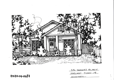
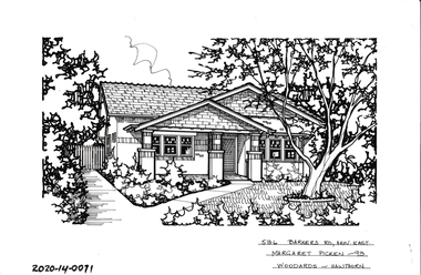
Drawing - Property Illustration, 546 Barkers Road, Hawthorn East
'After training as a Cartographic Draftsman within the mining industry, I worked as a property illustrator for real estate firms in the eastern suburbs of Melbourne for 23 years from 1983. I initially photographed houses with a Polaroid camera and made a 'thumbnail' sketch while there. The photos were used to scale off a sketch in pencil and then that sketch was overlaid with drafting film and the 'pen and ink' completed. The pens I used were the Rotring ‘Rapidigraph’ drafting pens. The ink was also made by Rotring (German).The film was ‘Rapidraw’, polyester drafting film, double matte. It takes a very fine line and doesn’t bleed. As well as house sketches, there were often floor plans and site plans ordered. Aerial sketches were ordered when the property needed an overall view.' (Margaret Picken, 2020)This property illustration is one of a series created by Margaret Picken for a range of real estate agents in Melbourne between c. 1983 and c. 2006. Each work is signed and dated by the artist.Gift of Margaret Picken, 2020Pen and ink property illustration on drafting film of 546 Barkers Road, Hawthorn East by Margaret Picken.546 Barkers Road, Haw E, Margaret Picken '98. Woodards.artist - margaret picken 1950- -
 Glen Eira Historical Society
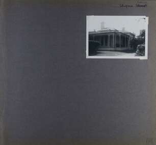
Album - Album page, Ulupna Road, Circa 1972
This album was created in approximately 1972 as part of a project by the Caulfield Historical Society to assist in identifying buildings worthy of preservation. The album is related to a Survey the Caulfield Historical Society developed in collaboration with the National Trust of Australia (Victoria) and Caulfield City Council to identify historic buildings within the City of Caulfield that warranted the protection of a National Trust Classification. Principal photographer thought to be Trevor Hart, member of Caulfield Historical Society. Most photographs were taken between 1966-1972 with a small number of photographs being older and from unknown sources. All photographs are black and white except where stated, with 386 photographs over 198 pages. Page 196 of Photograph Album with one photograph of a Victorian house on Ulupna RoadHandwritten: Ulupna Street (crossed out) Road [ top right] / 196 [bottom right]trevor hart, chimneys, porch, garden, single storey, return verandah, ulupna road, ormond, decorative brackets, cast iron frieze, cast iron columns, full length windows, villa residence, cast iron work, victorian period -
 Port Melbourne Historical & Preservation Society
Plan - Williamstown Road from Salmon Street to Prohasky Street, Engineering Department, Town of Port Melbourne, 1893 - 1919
Plan of Williamstown Road (Reconstruction of pitched portion). From Salmon Street to Prohasky Street. 1893 Loan Number 5.Reverse side - Williamstown Road, west of Salmon (Pitcher Construction).engineering - roads streets lanes and footpaths -
 Melbourne Tram Museum
Photograph - Black and White - demolishing cable tram track Swanston St 1925-1926
The photograph shows the demolition or removal of cable tram track in Swanston St Melbourne. The reference notes that work commenced 27/12/1925 and that conversion was completed by 24/1/1926. Given the worksite it would be most likely late December 1925. Note the large unsilenced air compressor, the large crowd of on-lookers and that Swanston St northbound seems to remain open for traffic. In the background are the Royal Hotel Arcade entrance and the Melbourne Town Hall. This photograph is Public Records Office photo H109 in the Victorian Railways collection. There are at least three similar photos in the PROV Collection.Yields information about the extent of work need to quickly convert the Swanston Street cable tram track to electric trams in about a month.Photograph - Black and White of the demolition of the cable tram track in Swanston St near Bourke St 1925-1926trams, tramways, cable trams, workmen, mmtb, swanston street, demolition, track work, air compressor, royal hotel arcade, conversion -
 Orbost & District Historical Society
programs, 1961
The Snowy River Shire was a local government area in the Australian Alps region of New South Wales, Australia from 1939 until May 2016. It was named after the Snowy River that runs through it. Prior to 1936, it had been named as Dalgety Shire since establishment in 1906. This opening of the Monaro - Gippsland Road took place on 4th May 1961. There had long been a movement in Monaro for the construction of a road to connect Monaro and Gippsland, via Inglebyra and Black Mountain. The only track was for stock, made by pioneers many years ago, and it was very circuitous. It was stated at a meeting at Dalgety that the road would open up large areas for settlement for grazing, and for timber suitable for bridgé building. The road would assist stock deal ing between Monaro and Gippsland. It would also considerably shorten the distance from Victoria for tourists visiting Canberra and Kosciusko. A committee was formed to put the proposal before the Dalgety Shire Council in the 1930s.This item is a useful research tool.Four copies of a road opening program. It has black print on white. There are black / white photographs, historical details and details of the official opening.program monaro-road snowy-river-shire -
 Ballarat Tramway Museum
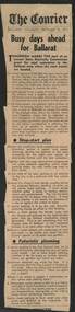
Newspaper, The Courier Ballarat, "Busy days ahead for Ballarat", 18/12/1971 12:00:00 AM
Newspaper clipping from the Ballarat Courier Editorial of 18/12/1971 about the reconstruction of Sturt St. to remove the tram tracks and the debate about whether cars should park along the central median strip. Dec 19 was the start of the annual SEC grant for road restoration in the Ballarat area where tram track are located. Discussion over whether there should be centre of the road parking.trams, tramways, road works, track removal, sturt st, city of ballaarat -
 Kew Historical Society Inc
Plan - Subdivision Plan, J R Mathers & McMillan, Normanby Estate, c.1913
The Kew Historical Society's map collection includes a substantial number of real estate subdivision plans, mainly of Kew but also of surrounding suburbs in Melbourne. Most of the subdivision plans date from the 1920s and 1930s when the districts old homes and local farmland were being split up to accommodate residential growth in the postwar period. These early plans were assembled by a local firm, Jas R Mather & McMillan, which had an office in Cotham Road. Many of the plans, and sometimes photos, were annotated by the agents.Subdivision plans are historically important documents used as evidence for the growth of suburbs in Australia. They frequently provide information about when the land was sold as well as evidence relating to surveyors and real estate and financial agents. The numerous subdivision plans in the Kew Historical Society's collection represent working documents, ranging from the initial sketches made in planning a subdivision to printed plans on which auctioneers or agents listed the prices for which individual lots were sold. In a number of cases, the reverse of a subdivision plan in the collection includes a photograph of a house that was also for sale by the agent. These photographs provide significant heritage information relating house design and decoration, fencing and household gardens.The photograph may also be aesthetically significant depending on the importance of the photographic atelier.The Normanby Estate, which was adjacent to Normanby Road, Kew East, included thirty-one lots for sale. Streets on the subdivision plan include Adeney Avenue, Park Hill Road, Normanby Road, Weir Street and Wharton Street. Cotham Road and its tramway are shown nearby. The plan is interesting as it shows Wharton Street, named after the architect and town planner George Wharton, who was the first chairman of the Municipality of Kew. The street was to later be renamed Cecil Street. Also shown are proposed ‘Municipal Gardens’ where Parkhill Drive is now located."D" in top left corner. Stamped auctioneers contact details: "Jas. R. Mathers & Son & McMillan / Auctioneer & Land Salesmen, / 271 Collins Street / Melbourne" and Jas. R. Mathers / Estate & Financial Agent / Cotham Road / Kew".weir street - kew, wharton street - kew, normanby road - kew, cotham road - kew, municipal gardens - kew, park hill parkhill road - kew, braemar - kew, subdivision plans - kew -
 Glen Eira Historical Society
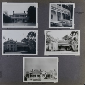
Album - Album page, Balaclava Road, Circa 1972
This photograph is part of the Caulfield Historical Album 1972. This album was created in approximately 1972 as part of a project by the Caulfield Historical Society to assist in identifying buildings worthy of preservation. The album is related to a Survey the Caulfield Historical Society developed in collaboration with the National Trust of Australia (Victoria) and Caulfield City Council to identify historic buildings within the City of Caulfield that warranted the protection of a National Trust Classification. Principal photographer thought to be Trevor Hart, member of Caulfield Historical Society. Most photographs were taken between 1966-1972 with a small number of photographs being older and from unknown sources. All photographs are black and white except where stated, with 386 photographs over 198 pages.Page 22 of Photograph Album - five black and white photographs of different styles of houses (2 photos for 2 houses and 1 for the last) with addresses written under each photograph and Balaclava Road written on the top right hand side.Hand written Balaclava Road [top right of page] / 6 BALACLAVA ROAD [under top left photo] / 6 BALACVAVA ROAD [ beside top right photo] / 73 BALACVAVA ROAD [under middle left photo] / 73 BALACVAVA ROAD [on top of middle right photo] / 239 BALACVAVA ROAD [under bottom photo] / 22 [bottom right]trevor hart, caulfield north, balaclava road, cars, mansions, houses, verandahs, cast iron work, balconies -
 Hawthorn Historical Society
Drawing - Property Illustration, 536 Barkers Road, Hawthorn
'After training as a Cartographic Draftsman within the mining industry, I worked as a property illustrator for real estate firms in the eastern suburbs of Melbourne for 23 years from 1983. I initially photographed houses with a Polaroid camera and made a 'thumbnail' sketch while there. The photos were used to scale off a sketch in pencil and then that sketch was overlaid with drafting film and the 'pen and ink' completed. The pens I used were the Rotring ‘Rapidigraph’ drafting pens. The ink was also made by Rotring (German).The film was ‘Rapidraw’, polyester drafting film, double matte. It takes a very fine line and doesn’t bleed. As well as house sketches, there were often floor plans and site plans ordered. Aerial sketches were ordered when the property needed an overall view.' (Margaret Picken, 2020)This property illustration is one of a series created by Margaret Picken for a range of real estate agents in Melbourne between c. 1983 and c. 2006. Each work is signed and dated by the artist.Gift of Margaret Picken, 2020Pen and ink property illustration on drafting film of 536 Barkers Road, Hawthorn by Margaret Picken.536 Barkers Road, Haw East, Margaret Picken '93. Woodards - Hawthorn.artist - margaret picken 1950- -
 Hawthorn Historical Society
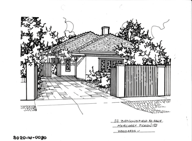
Drawing - Property Illustration, 22 Beaconsfield Road, Hawthorn
'After training as a Cartographic Draftsman within the mining industry, I worked as a property illustrator for real estate firms in the eastern suburbs of Melbourne for 23 years from 1983. I initially photographed houses with a Polaroid camera and made a 'thumbnail' sketch while there. The photos were used to scale off a sketch in pencil and then that sketch was overlaid with drafting film and the 'pen and ink' completed. The pens I used were the Rotring ‘Rapidigraph’ drafting pens. The ink was also made by Rotring (German).The film was ‘Rapidraw’, polyester drafting film, double matte. It takes a very fine line and doesn’t bleed. As well as house sketches, there were often floor plans and site plans ordered. Aerial sketches were ordered when the property needed an overall view.' (Margaret Picken, 2020)This property illustration is one of a series created by Margaret Picken for a range of real estate agents in Melbourne between c. 1983 and c. 2006. Each work is signed and dated by the artist.Gift of Margaret Picken, 2020Pen and ink property illustration on drafting film of 22 Beaconsfield Road, Hawthorn by Margaret Picken.22 Beaconsfield Road, Haw E, Margaret Picken '93. Woodards - Hawthorn.artist - margaret picken 1950- -
 Hawthorn Historical Society
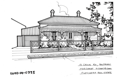
Drawing - Property Illustration, 13 Grove Road, Hawthorn
'After training as a Cartographic Draftsman within the mining industry, I worked as a property illustrator for real estate firms in the eastern suburbs of Melbourne for 23 years from 1983. I initially photographed houses with a Polaroid camera and made a 'thumbnail' sketch while there. The photos were used to scale off a sketch in pencil and then that sketch was overlaid with drafting film and the 'pen and ink' completed. The pens I used were the Rotring ‘Rapidigraph’ drafting pens. The ink was also made by Rotring (German).The film was ‘Rapidraw’, polyester drafting film, double matte. It takes a very fine line and doesn’t bleed. As well as house sketches, there were often floor plans and site plans ordered. Aerial sketches were ordered when the property needed an overall view.' (Margaret Picken, 2020)This property illustration is one of a series created by Margaret Picken for a range of real estate agents in Melbourne between c. 1983 and c. 2006. Each work is signed and dated by the artist.Gift of Margaret Picken, 2020Pen and ink property illustration on drafting film of 13 Grove Road, Hawthorn by Margaret Picken.13 Grove Road, Hawthorn, Margaret Picken c2001. Fletchers Real Estate. artist - margaret picken 1950- -
 Hume City Civic Collection
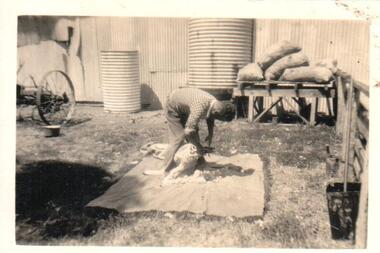
Photograph
A black and white photograph of a man shearing a sheep with shears in a farmyard with water tanks in the background with a stack of feed bags. The property if Bayview Farm, Davis Road, Diggers Rest.on back: BAYVIEW / DAVIS ROAD / DIGGERS RESTcullinan, uraina, eileen, diggers rest, bayview farm, chris, davis road, farmers, shearers, george evans collection -
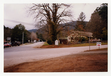 Marysville & District Historical Society
Photograph (Item) - Colour photograph, Unknown
A colour photograph taken of the corner of Pack Road and Falls Road in Marysville in Victoria.A colour photograph taken of the corner of Pack Road and Falls Road in Marysville in Victoria.pack road, falls road, marysville, victoria, photograph -
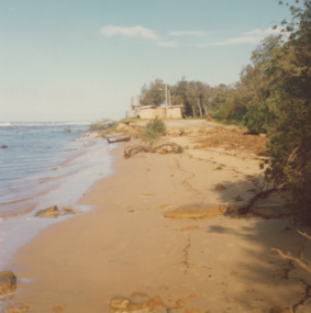 Lakes Entrance Historical Society
Photograph - Lake Tyers, Marie Fish, 1978
Two other colour photographs taken of damage from storms June/July 1978 showing that sand dune between lake and ocean was swept away, road and toilet block undermined numbers 03831.1 and 3831.2 size 9 x 8.5 cmColour photograph showing damage to shore and track to entrance at Lake Tyers Beach Victoriabeaches, waterways -
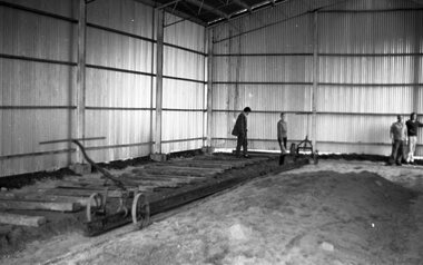 Ballarat Tramway Museum
Negative - Set of 4, Warren Doubleday, May or June 1972
Black and white negative - 4 scanned images - of the laying of the first track inside the BTPS depot - placing sleepers and rail on No. 3 road. May or June 1972,trams, tramways, btps, trackwork, depot -
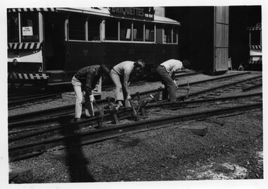 Ballarat Tramway Museum
Photograph - Black & White Photograph/s, c1974
Black and White photograph of BTPS volunteers (3) packing track - No. 1 and 2 road points, with No. 26 in the background. Photo taken c1974 as No. 26 in use as the "Museum". tramways, trams, btps, depot, trackwork, tram 26 -
 Melbourne Tram Museum
Photograph - Digital Image, Melbourne & Metropolitan Tramways Board (MMTB), Preston Workshops Office block and "Cameron Hall", c1940's
Digital Image of the Preston Workshops Office block and "Cameron Hall" from Miller St Preston or Northcote. Shows the track layout and road condition in front of the offices.trams, tramways, preston workshops, miller st -
 Melbourne Tram Museum
Slide, Melbourne & Metropolitan Tramways Board (MMTB), c1926
35mm colour slide TMSV copy slide of trackwork at St Kilda Junction, possibly soon after a change over to the new track in St Kilda Road. Has W 366 (St Kilda Beach) on the temporary or new track pending the construction of a road surface and the link to Wellington St. Photo may be from a photo held in the Public Records Office series. On the corner of Punt and St Kilda Road is s building advertising Schweppes Junction Motor service station."MP 30" in pencil on the side.trams, tramways, st kilda junction, trackwork, new tramways, w class, road works, tram 366 -
 Whitehorse Historical Society Inc.
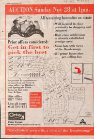
Newspaper - Article, Tally Ho Greens, 17/11/1993
Advertisement in the Post for auction of 81 home sites on the Tally Ho Estate.Advertisement in the Post for auction of 81 home sites on the Tally Ho Estate bordered by Springvale Road and Highbury Road, 28-11-1993.Advertisement in the Post for auction of 81 home sites on the Tally Ho Estate. auctions, springvale road, burwood east, highbury road, robinson drive, hoadley crescent, betts way, trainor place, sutton court, cole close, mcclelland way, kennard place, vision drive -
 Hawthorn Historical Society
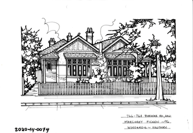
Drawing - Property Illustration, 766-768 Barkers Road, Hawthorn East
'After training as a Cartographic Draftsman within the mining industry, I worked as a property illustrator for real estate firms in the eastern suburbs of Melbourne for 23 years from 1983. I initially photographed houses with a Polaroid camera and made a 'thumbnail' sketch while there. The photos were used to scale off a sketch in pencil and then that sketch was overlaid with drafting film and the 'pen and ink' completed. The pens I used were the Rotring ‘Rapidigraph’ drafting pens. The ink was also made by Rotring (German).The film was ‘Rapidraw’, polyester drafting film, double matte. It takes a very fine line and doesn’t bleed. As well as house sketches, there were often floor plans and site plans ordered. Aerial sketches were ordered when the property needed an overall view.' (Margaret Picken, 2020)This property illustration is one of a series created by Margaret Picken for a range of real estate agents in Melbourne between c. 1983 and c. 2006. Each work is signed and dated by the artist.Gift of Margaret Picken, 2020Pen and ink property illustration on drafting film of 766-768 Barkers Road, Hawthorn East by Margaret Picken.766-768 Barkers Road, Haw, Margaret Picken '96. Woodards.artist - margaret picken 1950- -
 Otway Districts Historical Society
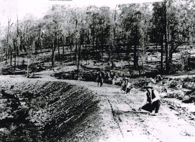
Photograph, Knox Collection, Surveying construction near Barongarook, 1900, 1900
In 1898 a recommendation for a railway of 2 ft 6 in gauge was handed down by the Parliamentary Standing Committee on Railways, to cost $138,000. Construction of the Colac-Beech Forest railway line began in 1900. About 100 men were employed in laying and ballasting the track while others formed the earthworks and the building of culverts and bridges. The earthworks of gravel ballast 150 mm deep were formed by horse and scoop or by shovel. Once the bed had been laid surveyors went along to check the layout, particularly all check rail curves and all 100 metre curves which the surveyors in the picture are doing.B/W. Three men surveying the construction of a curved bed on which track will be laid, near Barongarook, Victoria.colac; beech forest; barongarook; railways; -
 Melbourne Tram Museum
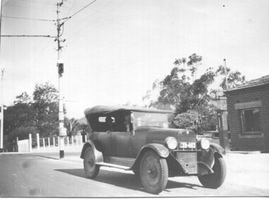
Photograph - 1926 Hudson Super 6 - Riversdale and Warragul Roads, Ray Pearson, 1930s
Photograph of a 1926 Hudson Super 6 parked at the tea room/kiosk on the intersection of Riversdale Road and Warragul Road. Distinguishing features of the car include the triangular badge on the radiator and the unusual disc wheels. The 1926 Hudson also had horizontal radiator shutters. On this vehicle, a finer mesh has been attached in front of the shutters. This is normal practice when insects such as locusts are in plague. At the time, Warragul Road was known as East Boundary Road. Behind the car on the tramway pole is a colour light tramway signal for the single-line section between Warragul Road and the terminus. On 1 July 1928, the Wattle Park line was extended from Boundary Road via Riversdale Road to Elgar Road. It was built as a single track with a passing loop about halfway along, plus a passing loop at the former Boundary Road terminus. The tramway pole has a stop sign and a telephone box as well. In a box of negatives received is an envelope noting the car was owned by Ray Pearson and photo taken during the 1930s. Inside the motor car are two people, the driver, and a lady. In the background is part of the tea rooms located at this corner with a Shell gravity-fed petrol bowser. At the time, petrol was not sold at Service Stations on a Sunday - Sunday trading laws, but they allowed Tea Rooms or kiosks to be open.Yields information the intersection of Warragul and Riversdale Road and MMTB single line signals.Black and white photograph on Velox paper.On rear in pencil "Colour light signal Wattle Park Route, down end loop line, corner of Riversdale and East Boundary Roads".trams, tramways, riversdale road, wattle park, warragul road, motor cars, hudson super 6, shell fuel, signalling, single line, ray pearson -
 Ringwood and District Historical Society
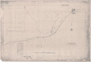
Map, Road Plan 108 - Gipps-land Road, Parishes of Bulleen and Warrandyte (Ringwood, Victoria) - 1855
Surveyor's map of the part of the main road from Melbourne to Gippsland following "Barker's Track" south of Mullum Mullum or Deep Creek. Map references include Roman numerals marking distances measured in Links between trees at turns in the road.Submitted to the Surveyor General (Signed) July 2nd 1855. -
4th/19th Prince of Wales's Light Horse Regiment Unit History Room
DVD, 1. Presentation of Guidon Oct 1963. 2. Farewell Parade M113 2006
DVD of the two title tracks. Track 1 has no sound4/19 PWLH badgedv, guidon, farewell m113 -
 Surrey Hills Historical Society Collection
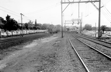
Photograph, Surrey Hills Station and car park
There are 3 tracks; the third track was built in 1971, which gives an approximate date for the photo. At this time the original station buildings were demolished and replaced by buildings constructed from concrete bricks and a second subway replaced the overhead footbridge. According to Roderick Smith, a local railway enthusiast, originally there had been 3 railway houses at the Mont Albert end of the northern car park. These were demolished to extend the car park. Certainly 8 Bedford Avenue, built as the station master's house was demolished at this time. The palm tree had been planted in the station master's front garden and was retained in a small garden bed within the car park. A black and white photograph of a station with cars parked on both sides of the 3 tracks. A Harris train is departing the station heading towards Mont Albert. A palm tree is prominent in the station car park to the north.1971, surrey hills station, railway stations, car parks, public transport, trains, railway lines, palm tree -
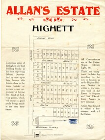 City of Kingston
Pamphlet - Colour, Allan's Estate Highett, 1930s
Sales plan for land in the suburb of Highett, bounded by Spring Road, Highett Road and Worthing Terrace.The developing urban area of Highett within the City of Kingston. This land sale pamphlet illustrates the subdivision of land within the municipality and the changing demographic of the district as new houses are constructed.Colour pamphlet advertising Allan's Estate, Highett. Incorporates a map of the estate bordered by Spring Road, Highett Road and Worthing Terrace.Handwritten in grey pencil on reverse: Allan's Estate / Highett Crossed out in blue pencil on front: Name and address of what appears to be a solicitorhighett, land sales, estate -
 Glen Eira Historical Society
Album - Album page, St Stephen's Presbyterian Church, Balaclava Road, Circa 1972
This photograph is part of the Caulfield Historical Album 1972. This album was created in approximately 1972 as part of a project by the Caulfield Historical Society to assist in identifying buildings worthy of preservation. The album is related to a Survey the Caulfield Historical Society developed in collaboration with the National Trust of Australia (Victoria) and Caulfield City Council to identify historic buildings within the City of Caulfield that warranted the protection of a National Trust Classification. Principal photographer thought to be Trevor Hart, member of Caulfield Historical Society. Most photographs were taken between 1966-1972 with a small number of photographs being older and from unknown sources. All photographs are black and white except where stated, with 386 photographs over 198 pages. From: Glen Eira Heritage Management Plan (1996) by Andrew Ward and Associates: In 1905, the land was vacant in Balaclava Road, north side, from Kooyong Road east to the right of way, except for one house. A block of this land was acquired by the Presbyterian community and a timber church erected there in 1910. In time, a larger church was required. After several years of fund raising led by George Kinross, a new red brick St Stephen's church was built in 1926 to the design of architects Haddon and Henderson. George Currie was the builder and the cost of construction was £5,100.Glen Eira Heritage Management Plan 1996 by Andrew Ward St Stephens has architectural importance as a noteworthy example of a Gothic Transitional design in the Arts and Crafts eclectic manner (see Stylistic Typology in National Trust's Historic Church's Study}. The facade treatment successfully combines Christian symbols with Gothic forms in the Arts and Crafts mode (comparable with Haddon's Presbyterian Church, Malvern (1906) and Haddon and Henderson's Oakleigh Church (1928). It is locally important as an example of Robert Haddon's work in Caulfield, where he also lived (4 Glenferrie St q.v.).Page 24 of Photograph Album with four black and white photographs of St Stephen's Presbyterian Church, with Balaclava Road written on the top right hand side. Three photos are of the exterior and one is a wide view of the inside towards the altar.Hand written: St Stephen's Presbyterian Church Balaclava Road [top right of page] / 24 [bottom right]trevor hart, caulfield north, balaclava road, george kinross, haddon and henderson, george currie, st stephen's, 1900's, 1920's, gothic transitional, christian symbols, arts and crafts, robert haddon, stylistic typology, gothic, presbyterian church, architects, red bricks, entrances -
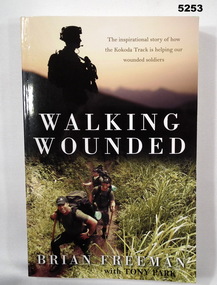 Bendigo Military Museum
Book - BOOK, THE KOKODA TRACK & WOUNDED SOLDIERS, Brian FREEMAN with Tony PARK, "Walking Wounded", 2013
"Walking Wounded/ The Inspirational Story of how/ the Kokoda Track is helping our/ wounded soldiers"Soft cover book. Soft cover - cardboard, white, gold and black print on front, spine and back. Illustrated in colour photographs - front top silhouette of soldier. Bottom - a group walking along a track. Back - a group crossing a water course. 265 pages - paper, - cut, plain, off white. Illustrated colour photographs.books, history, ww2, new guinea -
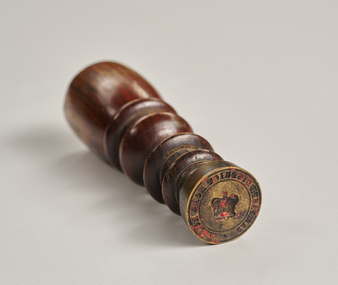 City of Greater Bendigo - Civic Collection
Ceremonial object - Common Seal, Campaspe District Road Board Seal
Wax seals have been used since the Middle Ages and are primarily used for legitimising and authenticating official documents. This wax seal was used by the Campaspe Road Board (later the Huntly Council). The first president of the Campaspe Road Board was Sir James Joseph Casey who was a member of the municipal council of Sandhurst prior to holding this position in 1861.Circular, brass seal with wooden handle. Remnants of red wax remain in seal. Campaspe District Road Boardhuntly shire (1866-1994), city of greater bendigo administration item -
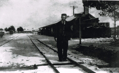 Otway Districts Historical Society
Photograph, Beech Forest Railway Station: Laurie McCabe in charge, 1920s
Laurie McCabe was in charge of Beech Forest Station until October 1929. When the timber industry went into decline because of poor markets and the crippling effects of the 1929 strike, and when road haulage signalled the beginning of a new transport era it was the beginning of the end. As a result staffing levels were severely cut over the period 1927/29 with the two station masters at Beech Forest and Gellibrand replaced by caretakers in October 1929. The line was then supervised by travelling station masters of whom Laurie McCabe was one of two.B/W. Laurie McCabe in charge of Beech Forest Railway Station in the 1920s, pictured on track one just down from the station buildings. Note the slight snow covering on the tracks.beech forest; railways; laurie mccabe;