Showing 1054 items matching "trail"
-
 Flagstaff Hill Maritime Museum and Village
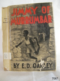
Book, Jimmy of Murrumbar, circa 1938
This novel, Jimmy of 'Murrumbar' by E.D. Oakley (Edward Daniel Oakley 1877-1962), is a children’s adventure story about an Australian indigenous boy who was educated in a mission and worked as a 'black tracker’ for the police to hunt down criminals in the bush and mountain region of the Grampian Ranges of Victoria. Oakely's parents, Thomas and Eliza, had a farm in Warrnambool called 'Oakbank'. Oakley worked at various jobs in the local district and later had his own wheat farms. When he returned to Warrnambool to build commercial premises and work in the retail industry. His influence encouraged Fletcher Jones to open a shop in Warrnambool. His novel - Jimmy of 'Murrumbar' - was written after he retired. The copy of the book in our collection does not have a publication date. The National Library of Australia lists two editions of this book, one dated 1938, the other is undetermined. It was published as part of a series called the Marcie Muir Collection of Australian children's books. No reference has been found to the author or any further works by him/her. The novel was reprinted as a reproduction in 2017 as a paperback and a leather bound edition 'Classic Reprint' by Forgotten Books. WARRNAMBOOL MECHANICS’ INSTITUTE Warrnambool's Mechanics' Institute (or Institution as it was sometimes called) was one of the earliest in Victoria. On 17th October 1853, a meeting was held where it was resolved to request the Lieutenant Governor of the Colony to grant land for the erection of a Mechanics' Institutes building. A committee was formed at the meeting and Richard Osburne chaired the first meeting of this committee. The land on the North West corner of Banyan and Merri Streets was granted but there were no funds to erect the building. The Formal Rights of the Warrnambool Mechanics' Institute's encompassed its aims and these were officially adopted in1859; "This Institution has for its object the diffusion of literary, scientific, and other useful knowledge amongst its members, excluding all controversial subjects, religious or political. These objects are sought to be obtained by means of a circulating library, a reading room, the establishment of classes, debates, and the occasional delivery of lectures on natural and experimental philosophy, mechanics, astronomy, chemistry, natural history, literature, and the useful and ornamental arts, particularly those which have a more immediate reference to the colony." The Warrnambool Mechanics' Institute opened its first reading room in November 1884 in the National School building at the corner of Banyan and Timor Streets. The Institute was funded by member subscription, payable on a quarterly, half-yearly or yearly basis. Samuel Hannaford, the Manager of the Warrnambool Bank of Australasia, was the first Honorary Secretary of the Mechanics' Institutes, and an early President and Vice-President. He also gave several of the early lectures in the Reading Room. Another early Secretary, Librarian and lecturer was Marmaduke Fisher, the teacher at the National School. Lecture topics included The Poets and Poetry of Ireland', 'The Birth and Development of the Earth', 'The Vertebrae - with Remarks on the pleasures resulting from the study of Natural History' and 'Architecture'. In 1856 the Reading Room was moved to James Hider's shop in Timor Street, and by 1864 it was located in the bookshop of Davies and Read. In the 1860's the Mechanics' Institute struggled as membership waned but in 1866, after a series of fundraising efforts, the committee was able to purchase land in Liebig Street, on a site then called Market Square, between the weighbridge and the fire station. A Mechanics' Institute building was opened at this site in August 1871. The following year four more rooms were added to the main Reading Room and in 1873 the Artisan School of Design was incorporated into the Institute. The same year Joseph Archibald established a Museum; however, it deteriorated when he was transferred to Bendigo in 1877. In 1880, with Archibald's return to Warrnambool, the Museum was re-established, and in 1885 a new building was built at the back of the Institute to accommodate the re-created School of Design, the Art Gallery and the Museum. In 1887 the Museum section was moved to the former courthouse in Timor Street (for some time the walls of the building formed part of the TAFE cafeteria but all is now demolished)). In 1911 the Museum was transferred back to the original building and the management of the Mechanics' Institute was handed over to the Warrnambool City Council. The Museum and Art Gallery became one and housed many fine works of art, and the Library continued to grow. The building was well patronised, with records showing that at the beginning of the 20th century there were between 500 and 800 visitors. During World War One the monthly figures were in the thousands, with 3,400 people visiting in January 1915. The Museum was a much loved Institution in Warrnambool until the contents of the Museum and Art Gallery were removed to make room for the Warrnambool City Council Engineers' Department. The contents were stored but many of the items were scattered or lost. When the original building was demolished the site became occupied by the Civic Centre, which included the new City Library. (The library was temporarily located in the old Palais building in Koroit Street.) In the process of reorganisation the Collection was distributed amongst the community groups: -The new City Library took some of the historical books and some important documents, historic photographs and newspapers. -The Art Gallery kept the 19th Century art collection and some of the artefacts from the museum. -The Historical Society has some items -The State Museum has some items -Some items were destroyed -Flagstaff Hill Maritime Village has old newspapers, Government Gazettes, most of the Mechanics' Institute Library, ledgers and documents connected to the Mechanics' Institute Library, some framed and unframed artworks and some photographs. The Warrnambool Mechanics' Institute Library book collection is deemed to be of great importance because it is one of the few collections in an almost intact state, and many of the books are now very rare and of great value. This novel is historically significant for its story, representing the changes to Australian Indigenous culture and life after colonisation. The book appears to be that this is the only work written by E.D. Oakley. It is locally significant for being written by an early prominent Warrnambool family member. Jimmy of Murrumbar : A Story of the Amazing Ability and Fidelity of an Australian Black Tracker Author: E D Oakley (Edward Daniel Oakley) Publisher: Osboldstone & Co, Pty Ltd, Melbourne, Australia The label on the spine with typed text R.A. 823 OAK The front loose endpaper has a sticker from Warrnambool Children’s Library shipwrecked-coast, flagstaff-hill, flagstaff-hill-maritime-museum, warrnambool, maritime-museum, shipwreck-coast, flagstaff-hill-maritime-village, shipwrecked-artefact, book, pattison collection, warrnambool library, warrnambool mechanics’ institute, ralph eric pattison, corangamite regional library service, warrnambool city librarian, mechanics’ institute library, victorian library board, warrnambool books and records, warrnambool children’s library, jimmy of murrumbar, e d oakley, edward daniel oakley, novel, young adult novel, juvenile fiction, australian black tracker, law enforcement - police trackers, tracking and trailing in australia, australian bush, grampian ranges in victoria, warrnambool history, fletcher jones, oakbank, thomas and eliza oakley, indigenous literature, indigenous australians -
 Kiewa Valley Historical Society
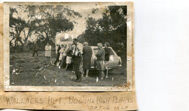
Photographs x 2- Bus tour of Wallaces Hut, 20/02/1970
Wallace's hut was built in 1889 and is probably the oldest surviving hut on the high plains of north-east Victoria. It was built in six weeks by Irish immigrant brothers Arthur, William and Stewart Wallace among old snow gums on a grassy plain above the snowline. The brothers held grazing leases on the High Plains and the hut was built to provide shelter for the cattlemen working there. It is probably the oldest hut on the Victorian high plains. It is part of the early history of hydroelectricity in the state and has links with early SEC meteorological data recording in the area Apart from its historical significance, Wallace’s Hut is a popular stop for tourists and photographers and is the starting point for the Wallace’s Heritage trail, which is a popular and well used hiking track, by locals and visitors alike.2 black and white photographs mounted on buff card. Photos taken during a bus trip to Wallace's Hut on Feb. 20, 1970 1. Group of local Kiewa Valley residents on a bus tour to Wallace's hut 2. Group of adults and children pictured outside Wallace's hut1. Handwritten in black ink on bottom of photo 'Wallace's Hut, Bogong High Plains, 20 Feb, 1970 2. No markingswallace's hut, bogong high plains, bush walking, cattlemen -
 Eltham District Historical Society Inc
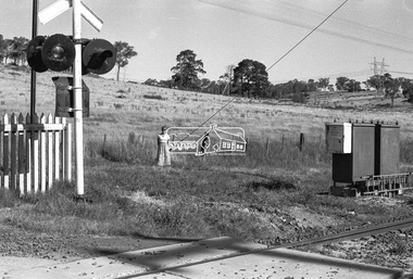
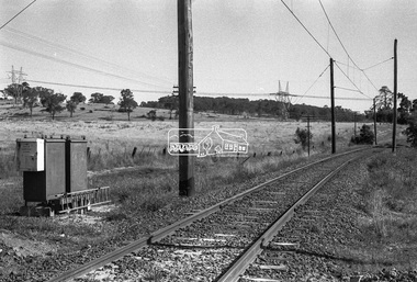
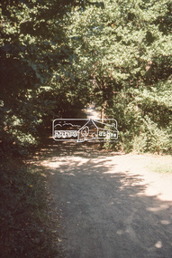
Negative - Photograph, Shire of Eltham, Allendale Road level crossing, Eltham, Jan. 1980
allendale road, diamond creek trail, hurstbridge railway line, level crossing, power transmission lines, railway crossing -
 Eltham District Historical Society Inc
Negative - Photograph, Shire of Eltham, Allendale Road level crossing, Eltham, Jan. 1980
allendale road, diamond creek trail, hurstbridge railway line, level crossing, power transmission lines, railway crossing -
 Eltham District Historical Society Inc
Photograph, Fay Bridge, Centenary celebration, Monash Bridge, Hurstbridge, 7 November 2017
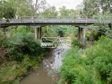
The area of Hurstbridge was originally known as Hurst’s-bridge after the timber bridge built over the Diamond Creek near Hurst’s station in late 1881/early 1882. It was replaced by a new concrete bridge designed by Sir John Monash over the Diamond Creek near Hurst's home of 'Mia Mia' at Hurstbridge. The official opening of the new Monash bridge at Hurstbridge was held 3 November 1917.fay bridge collection, 2017-11-07, hurstbridge, hurstbridge heritage trail, monash bridge, ruins -
 Eltham District Historical Society Inc
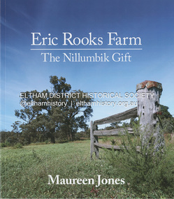
Book, Maureen Jones, Eric Rooks Farm: the Nillumbik gift, 2022
History of the Rooks family and farm, located at 167 Allendale Road, Diamond Creek. The property was first settled in 1865 and held by four generations of the family always retaining its rural landscape. Family archives and historical newspaper reports supplemented with photographs from the collection of Nillumbik Historical Society have contributed to the telling of this family history and history of the property. Hailing from Cambridgeshire England, the Diamond Creek pioneer settler was Isaac Rooks. He, his brothers and descendants are all profiled. The story of the Maroondah Aqueduct which passed through the property is also discussed including the recent development of the Aqueduct trail. More recently managed by Eric Rooks whose story is also represented, Eric donated the property to the National Trust upon his death in 2020 with the condition that a Reserve would be established.93 pagesnon-fictionHistory of the Rooks family and farm, located at 167 Allendale Road, Diamond Creek. The property was first settled in 1865 and held by four generations of the family always retaining its rural landscape. Family archives and historical newspaper reports supplemented with photographs from the collection of Nillumbik Historical Society have contributed to the telling of this family history and history of the property. Hailing from Cambridgeshire England, the Diamond Creek pioneer settler was Isaac Rooks. He, his brothers and descendants are all profiled. The story of the Maroondah Aqueduct which passed through the property is also discussed including the recent development of the Aqueduct trail. More recently managed by Eric Rooks whose story is also represented, Eric donated the property to the National Trust upon his death in 2020 with the condition that a Reserve would be established.diamond creek, rooks family, isaac rooks, maroondah aqueduct, maroondah aqueduct trail -
 Eltham District Historical Society Inc
Album - Photograph Album, J.A. McDonald, Bridge and Road Reconstruction Works, Shire of Eltham, 1952-1962
J.A. McDonald produced this record in the course of his responsibilities as Shire Engineer for Eltham Shire Council.Record of various Shire of Eltham infrastructure works undertaken during the period of 1952-1962 involving bridge and road reconstruction projects, sometimes with Eltham Shire Council Project Reference numbers quoted. It was during this period that a number of significant improvements were made to roads and new bridges constructed within the shire that remain in place as of present day (2022). In many situations, the photos provide a tangible visible record of infrastructure that existed throughout the early days of the Shire. The album was put together by or under the direction of the Shire Engineer, J.A. McDonald.a. gillies, alistair knox park, benchmark studies, bend of islands, blease road, box hill state school, box hill teachers college, box hill tip, bridge construction, bridge street bridge, bridge, brisbane street, brougham steet, bulldozer, cecil street, charis pelling, cherry tree road, city of preston, cr. a. brinkkotter, cr. charis pelling, cranes, cromwell street, diamond creek (creek), diamond street, dixons creek bridge, dixon's creek road, drott, eltham leisure centre, eltham north, eltham police station, eltham, eltham-yarra glen road, f. wood, fitzsimons lane bridge, flat rock road, flood damage, floods, floodwater, footpaths and gutters, ford service garage, g. blair, garden hill, glen park bridge, glenauburn road, grand hotel, haldane road, healesville, healesville-yarra glen road, heidelberg-kinglake road, henley road bridge, henley road, hill property, hurstbridge water scheme, hurstbridge, hurstbridge-arthurs creek road, infrastructure, j. jolly, kangaroo ground, kangaroo ground-queenstown road, kangaroo ground-st andrews road, lilydale shire office, long gully bridge, long gully creek, long gully road, long gully, lower plenty bridge, lower plenty footbridge, lower plenty oval, lower plenty road, lower plenty, main road, methodist church, montmorency, mount pleasant road, new holland, old healesville road, opening ceremony, oxley bridge, para road, paul creek bridge, paul creek road, paul krafeznk, pinnacle lane, plaques, plenty river trail, plenty river, presbyterian church, prof donald thomson, pryor street, railway crossing, railway parade, rattray road, reconstruction works, reichelt avenue, research (vic.), research oval, road construction, rymers corner, shire of eltham, shire of whittlesea, silvan road bridge, silver street bridge, silver street, sir dallas brooks, smedley property, st andrews, steels creek, susan street, tarrawarra, tony carberry, uniting church, upper yarra dam, upper yarra reservoir, w.e. wolf, waterfall property, watsons creek, wattletree road bridge, wattletree road, wattletree road bridge, worlingworth, yarra glen, york street, yow yow creek -
 Eltham District Historical Society Inc
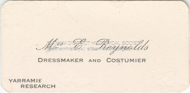
Business Card, Mrs E. Reynolds, Dressmaker and Costumer, Yarramie, Research, Vic
The Reynolds family were early settlers in Research. The Reynolds/ Prior collection of photographs were taken by Tom Prior, the maternal uncle of Ivy Reynolds, around 1900 and the 60 photos in the album give a fine overview of many of the landmarks of Research and Eltham over 100 years ago. lvy lived in the family home for many years at 106 Thompson Cres Research. Ivy's father, Ernst Richard Reynolds and grandfather, Richard Reynolds, lived at the same address. Ivy's father Richard worked for Mr. Trail on his property in Research. Reynolds Road is named after the family. Mr Tom Prior (wife Eva) worked at the Melbourne zoo. He was very innovative and made his own camera, using the black cloth hood to exclude the light. The photographs are a reminder of the rural nature of Research and Eltham and its rich heritage. Buisness card, manilla coloured cardreynolds prior collection, research (vic.), e. reynolds, dressmaker shop -
 Eltham District Historical Society Inc
Photograph (Item) - Negative, Mathew Wakefield, Eltham Community Photographic Survey Entry, 1988
Mathew Wakefield 1988 Entrant No. 40 Ref: Series 34, Items 87, 88 The images in this record were not selected for inclusion. SHIRE OF ELTHAM COMMUNITY PHOTOGRAPHIC SURVEY Photography is an artform which many of us practice, sometimes purely for artistic pursuit, sometimes to record the people and events in our lives. In 1988, as part of a local Bicentennial project, the Shire of Eltham conducted the Eltham Community Photographic Survey. Up to 100 entries were to be selected by a panel of photographers for entry into the Eltham Photographic Survey Exhibition. Entries had to be submitted by May 13, 1988. Entrants whose images were selected for the exhibition were contacted and requested to further submit an entry form providing entrant’s name, area of residence, age, and proposed captions. These details were then used to produce labels for the exhibition mounts. Where negatives had not been supplied, these were requested to support the display of printed enlargements mounted on 10” x 8” cardboard. The mounted prints were made available post exhibition for sale at $8.50 each for colour prints and $7.00 for B&W prints. Residents in the Shire were invited to collect a free roll of film and take a photograph of what they either liked or did not like about the area. A total of 160 entrants submitted multiple entries for the exhibition. Of those selected for exhibition, entrants ranged in age from 9 to 70 years. All custom colour and black and white printing for the exhibition was completed by Wattle Studios of Eltham. The Eltham Photographic Survey was jointly auspiced by the Shire of Eltham and Wattle Studios, of 953 Main Road, Eltham. The project was greatly assisted by: • David McRitchie, Media Studies Lecturer Victoria College, Rusden Campus. • Ian and Annette Toohill of Wattle Studios • Tracy Naughton, Eltham Community Arts Officer • Neville Emerson Pty. Ltd. • Superior Press, Eltham • Kodak Australasia Pty. Ltd. • Agfa Gevaert Ltd. • Townsend Colourtech Pty. Ltd. • The Australian Bicentennial Authority • Eleanor Bowers, Secretary, Eltham Arts Council The exhibition was placed on display in the Woolworths Arcade, Eltham between Monday June 6th and Saturday June 11, 1988. It was also intended to hold the exhibition at a venue in the Shire’s North Riding from Monday, June 20 to Friday June 24. It was then displayed at the Were Street Theatre, Montmorency from Friday, June 24 to Thursday, July 7. Series 34: Eltham Community Photographic Survey 1988 - Prints & Documentation Series consists of 117 photographs of Shire scenes taken by members of the community. Items I - 41 are larger photographs mounted on card, which were exhibited. Items 42 - 117 are unmounted copies, alternative takes and other entries. Corresponding negatives contained in Series 35: Eltham Community Photographic Survey 1988 – Negatives which consists of 267 colour and B&W negatives and one colour slide of Shire scenes taken by members of the community. The negatives are arranged by the entrant number of the photographer. The Eltham Community Photographic Survey collection is significant to the local community as it was curated by the local community - ordinary people of all ages - representing what they liked and did not like in the area where they lived. It represents an unfiltered representation of the Shire of Eltham as it was in 1988. It also represents one of many projects as part of the national programme of events and celebrations to commemorate the bicentenary. It is a time capsule of life in the 1980s of this urban and rural municipality in Melbourne's north. shire of eltham archives, bicentennial project, eltham community photographic survey, dalton street, eltham, film - fuji 100, main road, mathew wakefield, scan - 35mm negative, series 35, wiingrove park trail, yarra river, beard street, food plus service station -
 Glen Eira Historical Society
Document - Cantala
Various documents and correspondence detailing the history of the house and land on the corner of Dandenong and Waiora Roads, Caulfield, known as Cantala before being demolished and the land subdivided. The first document is a typed 3 page history from Caulfield Historical Society dated 02/1974, describing the owner of the property, Septimus Miller, as well as architectural features of the house Cantala. The second document is one page of typed correspondence from T J Hart to the editor of Southern Cross, dated 01/11/1973, describing the architectural features and history of Cantala. The file also includes a copy of a typed letter from Brighton Historical Society concerning research conducted about Cantala and the subdivision and detailing the owners and occupiers of flats erected where Cantala stood. Accompanying this document is a one page handwritten note providing the same details. Finally, the file includes a one page photocopy, undated, of an entry in Who’s Who in the World of Women of Mrs Septimus Miller (Muriel), the second wife and widow of Septimus Miller.miller septimus, miller henry money, mattinson elizabeth, bell clara johnstone, stewart gwendoline, henderson helen muriel, miller ronald nevil damian, salway william, hart t j, miller helen, pirera m t, fetter a, bullock hilary, landells rosalind, redleap, cantala, caulfield, caulfiled north, dandenong road, wiora, waiora road, alma road, brighton cemetery, caulfield racecourse, findon avenue, cantala avenue, olgita, rivoli, caulfield historical society, victoria racing club, horse racing, italianate style, art deco, architectural styles, architectural features, balconies, towers, stairs, bay windows, mansions, stables, land subdivisions, monuments and memorials, gothic (revival) architecture, drawing rooms, walking trails, parks and reserves, gardens, flats -
 Eltham District Historical Society Inc
Calendar, Nillumbik Community Calendar 1996: Nillumbik The Places and the People, 1995
Community Project. One of a series of calendars which the Shire of Eltham and the Shire of Nillumbik published annually Photography by Graham Hosking Photography. Monthly calendar printed in landscape mode, with feature photograph and template of dates for each of the 12 months presented. Includes advertisements. Back of the calendar includes a list of emergency numbers.calendar,1996,shire of nillumbik,research primary school,eltham north adventure playground,edendale gateway,tony trembath,eltham leisure centre,diamond valley railway,kangaroo ground pony club,eltham community and reception centre,eltham community centre,shire of nillumbik,swimming pool,yarra river,, diamond creek trail,yarrambat golf course,sugar loaf reservoir,map -
 Eltham District Historical Society Inc
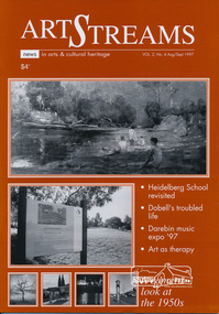
Journal, Peter Doughtery, ArtStreams: News in arts and cultural heritage; Vol. 2, No. 4, Aug-Sep 1997, 1997
Vol. 2, No. 4, Aug-Sep 1997 CONTENTS A PAINTER'S PROGRESS ARRESTED William Dobell's battle for artistic survival 3 WALK WITH THE HEIDELBERG SCHOOL A chance to revisit the sites of Australia's best-loved paintings 4 A DREAM REVISITED Once more Eltham has a real bookshop 8 THE ART OF RECYCLING Painter Baz Blakeney creates his own materials from the scrap heap 10 POETRY Sandy Jeffs 12 MOTHER AND CHILD The concept of arts therapy 13 IMAGES OF THE '50s A Czech migrant's view of Melbourne 16 SHORT STORY Helen Lucas 18 BOOK REVIEWS The life of Clem and Nine Christensen 21 Music theatre of Melbourne 23 THE CHINA QUESTION Exhibition of modern Chinese art 24 THEATRE REVIEWS 26 Music 27 CD REVIEW 28 SHORT STORY 29 EXHIBITIONS 30 "Peter Dougherty has been involved in the local art scene for many years. As publisher and editor of the arts magazine Artstreams, his comments on the various branches of the arts are widely respected. His "The Arts" column in the Diamond Valley Leader presents a brief summary for a much wider cross section of the local community. Peter also operates his own gallery and the Artstreams Cafe at the St Andrews market. Peter has a wealth of knowledge about present day and historical aspects of local art and artists." - Eltham District Historical Society Newsletter No. 161, March 2005Colour front and back cover with feature articles and literary pieces with photographs and advertisements printed in black and white. 36 pages, 30 cm. Vol. 1, no. 1 (Nov. 1996) - Vol. 10, no. 5 (summer ed. 2005/06) art streams, heidelberg artists' trail, heidelberg school artists' trail, 1950s, william dobell, eltham bookshop, meera govil, baz blakeney, junk art, found objects, sandy jeffs, art therapy, michelle lonsdale, eltham community health centre, kath armour, raddie sindelka, helen lucas, sandon mcleod, clem christesen, nina christesen, judith armstrong, llobex picture framing, john jenkins, rainer linz, harriet dance, chinese art, bulleen art & garden centre, studio framing eltham, eltham little theartre, great darebin music expo, judy jacques, lucinda mcknight, les kossatz, barry dickens, diamond valley singers, eltham community orchestras, helen o'grady children's drama academy, alan marshall short story award -
 Eltham District Historical Society Inc
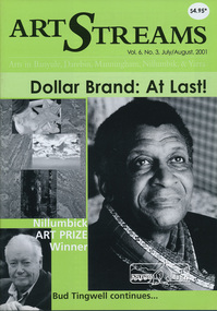
Journal, Peter Doughtery, ArtStreams: Arts in Banyule, Darebin, Manningham, Nillumbik & Yarra; Vol. 6, No. 3, Jul-Aug 2001, 2001
Vol. 6, No. 3, Jul-Aug 2001 CONTENTS Vale Robert Klippel 1920 – 2001 2 John Young Making sense of the spirit of our times 3 Bud Tingwell's magnificent obsession 18 Winter Dreaming A concert for reconciliation 6 Short Story A mop of gardens by Gillion Mears 8 The Celts invade Brunswick Folk music at the East 12 Book Review John Jenkins on Les Murray 14 Abdullah Ibrahim and the Dollar Brand Trio 21 Heidelberg to Heide Streeton and Nolan: the common ground 22 Australian classical music Elizabeth Scarlet 23 Art Therapy Possibilities for change 24 Artin' about 26 Wining & Dining 30 Artists' Services and Teaching 32 "Peter Dougherty has been involved in the local art scene for many years. As publisher and editor of the arts magazine Artstreams, his comments on the various branches of the arts are widely respected. His "The Arts" column in the Diamond Valley Leader presents a brief summary for a much wider cross section of the local community. Peter also operates his own gallery and the Artstreams Cafe at the St Andrews market. Peter has a wealth of knowledge about present day and historical aspects of local art and artists." - Eltham District Historical Society Newsletter No. 161, March 2005Colour front and back cover with feature articles and literary pieces with photographs and advertisements printed in black and white. 36 pages, 30 cm. Vol. 1, no. 1 (Nov. 1996) - Vol. 10, no. 5 (summer ed. 2005/06) art streams, winter in banyule, john young, aboriginal reconciliation, the great darebin music feast, gilian mears, montsalvat, st andrews hotel, kinglake hotel, folk song & dance society of victoria, bulleen art & garden centre, plenty views golf park, dynamic vegies, bud tingwell, eltham wiregrass gallery, abdullah ibrahim, willy wonka's ice cream gourmet food, heide museum of modern art, heidelberg artists' trail, heidelberg school artists' trail, heidelberg school, art therapy, jody kernutt, thompson's pharmacy -
 Eltham District Historical Society Inc
Photograph, Peter Pidgeon, Manna Gums, Main Road Bridge, Eltham South, 8 Sep. 2021
The original timber bridge over the Diamond Creek was built around 1840. It was destroyed by floodwaters in October 1923. A temporary bridge was rigged up but further damaged in April 1924. A new concrete bridge was built and opened in October 1926. The bridge decking was widened along with Main Road to Dalton Street by the Road Construction Authority in 1984., The uygraded bridge was opened in October 1984, 78 years after its original opening.These trees are not only significant for the natural environment but also present a navigational beacon back in time as the environmental landscape is developed around them.Born Digitaleltham south, main road bridge, manna gum, diamond creek trail -
 Eltham District Historical Society Inc
Photograph, Peter Pidgeon, Diamond Creek near Main Road Bridge, Eltham South, 8 Sep. 2021
Evidence of flooding from recent winter and early spring rainBorn Digitaleltham south, diamond creek trail, diamond creek (creek), floods -
 Eltham District Historical Society Inc
Photograph, Peter Pidgeon, Diamond Creek near Main Road Bridge, Eltham South, 8 Sep. 2021
Evidence of flooding from recent winter and early spring rainBorn Digitaleltham south, diamond creek trail, diamond creek (creek), floods -
 Eltham District Historical Society Inc
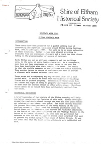
Document, Russell Yeoman, Tour of Historic Buildings and Locations, 1978
Self guided heritage tour information produced by the Shire of Eltham Historical Society for 1978 Eltham Community Festival of 36 locations each numbered on accompanying map. Locations and detail provided current to 1978: 1. ELTHAM SHOPPING CENTRE Whilst very little remains in the centre of historical importance, this area has interest as the "village" which developed over many years following the opening of the railway from Melbourne in 1902. Previously the shopping centre had been spread out over a long length of Main Road to the south. Shops have been continuously demolished or remodelled and the majority of buildings date from the 1950's or later. The recently erected Post Office replaced the "old" Post Office opened on the same site only in 1958. 2. WOOLWORTHS ELTHAM VILLAGE Part of the site of this modern shopping development was occupied by the former Eltham Shire Offices and Hall. The hall was paid for by public subscription whilst the Council raised a loan for the offices. The combined building was opened in 1941. It served as office and Council meeting place until 1965 and as the hall until its demolition in 1970. 3. ELTHAM WAR MEMORIAL The complex of buildings adjoining the present Shire Offices were financed by public subscription as a Memorial following World War II. Their construction and for many years their operation was organised by the now disbanded Eltham War Memorial Committee. The original buildings were the; Infant Welfare Centre, Children’s Library (now War Memorial Hall and Dental Clinic) and Kindergarten. In later years the Elderly Citizens Club was built at the rear. 4. ELTHAM SHIRE OFFICES These offices were opened in 1965 and extended in 1971 to provide additional office accommodation and the Eltham Library. They represent the last of a long line of offices and meeting places of the Eltham Shire Council and its predecessor the Eltham District Road Board. The building occupies the former site of Shillinglaw Cottage. The three tall cypress trees which stood in front of the Cottage have been retained as a feature of the office surrounds. 5. OUR LADY'S CHURCH AND SCHOOL The Catholic Church and School complex opposite the Shires Offices shows a number of stages in the development of Eltham township. The recently constructed church adjoins its predecessor (now the parish centre). Many years ago the Catholic Church was located opposite Wingrove Park and the present central site follows the northerly drift of the township. 6. SHILLINGLAW COTTAGE The Cottage was built in 1859 by George Stebbing, a local builder who was responsible for a number of other prominent buildings in the area. Its removal from the site of the Shire Offices and re-erection on the present site was financed by public subscription. It is built of handmade bricks laid in Flemish Bond with an unusual design featuring burnt "leader" bricks over the whole facade. The Cottage is occupied by Eltham Fleececrafts and will be open during the Festival and at other times during weekends. It is classified by the National Trust. 7. RAILWAY BRIDGE The timber trestle bridge over the Diamond Creek was built in 1901. Whilst all of its timbers have been replaced at various times over the years the only change to its character has been the addition of pylons and wiring for electric trains in 1923. It is one of very few similar bridges remaining in the metropolitan area. In 1976 a proposal to replace the bridge with an earth embankment and large culvert pipes was abandoned following community protests. The bridge, however, remains under threat because of the necessity for future deuplication of the railway line. 8. ELTHAM CENTPAL PARK The area between the railway and the creek has for many years been used as a park which included Eltham' s main football oval. The access road, Panther Place is named after Eltham's team playing in the Diamond Valley League. In recent years a large area extending to Bridge Street and locally known as the Town Park has been landscaped and added to the area. The excellent blending of the park with the natural landscape of the creek valley has earned a National Trust Landscape Classification. 9. OLD BAKERY On the southern corner of York Street and Main Road is an old house with a shop front which was for many years the local baker's shop. The brick bakery at the rear is of somewhat later vintage than the house. 10. BRIDGE STREET CUTTING Before reconstruction of Main Road this intersection had deep cutting embankments on all four corners, forming a distinctive feature of the entrance to Eltham. Roadworks and private development have levelled the land on the low side of the road. A memorial to the Eltham soldiers of World War I which was located at the north-western corner is now situated at the Eltham R.S.L. 11. HILLTOP MILK BAR For many years this was the site of the Eltham Post Office under the control of the Hunniford family and later their descendants the Burgoynes. It was transferred to this site in 1855, although at that time the building apparently fronted Bridge Str e et. The site contained Eltham's first telephone exchange. The post office was relocated in 1954 but the shop was operated until recently by the Burgoyne family who still own the surrounding land. 12. UNITING CHURCH and former C.B.A. BANK The former Methodist Church was built in 1880 by George Stebbing. The Sunday School extension was built in 1929 and there have been more recent extensions. The adjoining opportunity shop was built as a bank in 1874 and purchased by the Methodist Church in 1954. 13. R.S.L. HALL, TELEPHONE EXCHANGE These relatively recent buildings occupy the site of a row of shops forming part of the early ribbon of business development along Main Road. In front of the R.S.L. building is the World War I Memorial relocated from the corner of Bridge Street and Main Road. 14. ELTHAM COMMUNITY CENTRE Australia's first mudbrick "community building" was opened in April this year. Part of the site of the building was purchased in 1856 by Henry Dendy (of Brighton fame). At the rear of the land near the creek was a steam flour mill whilst Dendy's house was at the Main Road frontage of the land. His purchase totalled about 2 Ha (5 acres) and included land on the opposite side of Maria Street (Main Road). Dendy became a prominent member of the Eltham community and served one term as President of the Eltham District Road Board. In 1867 Dendy sold his land and business to William Ford of Malmsbury and shifted to Walhalla. The avenue of trees leading past the Community Centre to the creek may well have bordered the track to the mill. 15. ELTHAM HOTEL The original part of this hotel was built in 1927 following the burning of the former Watson's Eltham Hotel on the same site. The car park on the opposite side of Main Road was also the site of a hotel variously known over the years as; the Fountain of Friendship, the Fountain and the Evelyn Arms. As the Fountain of Friendship it was the first meeting place of the Eltham District Road Board in 1856. 16. ST. MARGARET'S CHURCH, PITT STREET In 1860 Henry Dendy was appointed Chairman of a committee to establish a church of England in Eltham. He donated part of his land in Pitt Street and in 1861 the church was opened. It was built by George Stebbing and remains in a well preserved state today. Th adjoining old vicarage is now named Dendy Hou se. A new mudbrick church hall is under construction on the site. The church and Dendy House are now listed on the Register of Historic Buildings. 17. NO. 86 PITT STREET Cottage built by George Stebbing and believed to be his home for some years in the 1850s. 18. LIVING AND LEARNING CENTRE The house was built in the 1850s with the kitchen at the front being added about 40 years later. By the creek below the house a number of early Eltham industries were located. These included a tannery and a brewery. 19. ELTHAM COURT HOUSE A Court of Petty Sessions was established in Eltham in 1858 and the present building dates from 1860. It is the oldest public building remaining in Eltham. In its early days the building was used as the meeting place and office of the Eltham District Road Board and as an overflow classroom for the local school. The Court House has been classified by the National Trust. The citation states that it is an example of the simple form of early brick Court House with gabled roof and porch. 20. LANDS DEPARTMENT OFFICE This building is the former police station and is probably of about the same age as the Court House. The lockup at the rear has been demolished but the old stables remain as garages. A licence was first granted for a police station at Eltham in 1856. 21. JARROLD COTTAGE The old Cottage opposite Dalton Street was formerly owned by the Jarrold family. Early records indicate that this was the building leased from the Jarrolds as a temporary police station prior to construction of the building on the corner of Brougham Street. The small building on the corner of the property was used as a boot repairer's shop. The elevated studio at the rear is a more recent construction by the present owners. 22. STATE SCHOOL RESIDENCE Erected in 1891 23. WINGROVE COTTAGE This building fills an important place in the history of Eltham and is now used as a medical clinic. It was built in 1858 for Charles S. Wingrove who was Secretary to the Eltham District Road Board and Shire Council from 1858 to 1904. During part of this period he was also Shire Engineer and was Secretary to the Heidelberg Road Board. The house was used as the office of the Board and Council for many years. Wingrove is buried in the cemetery at St. Helena. 24. WINGROVE PARK The parkland opposite Wingrove Cottage has been named after Charles Wingrove. The old Manna Gums are an outstanding feature of the park. 25. ELTHAM FRI.MARY SCHOOL NO. 209 The school first opened in the slab building in 1855 and operated from the present site since 1857. The oldest part of the present school is the stone building erected in 1876. The first school teacher, David Clark remained at the school until 1888. This school is the government township and has always been known as the Eltham School. An earlier school (no.371) known as Little Eltham School operated in Swan Street from 1853 to 1872. 26. "SHOESTRING" This house was built for school teacher David Clark. It has been extensively extended in recent years but the extensions do not detract from the character of the older part of the building. 27. ELTHAM CEMETERY The cemetery contains the graves of many of the district's pioneers . 28. MONTSALVAT This unique complex of buildings was commenced in 1935 by the late Justus Jorgensen and its development has extended over many years. Montsalvat has exerted a significant impact on Eltham The earth and stone construction of many of the buildings has influenced local architecture to a great extent and it has served as a "nerve centre" of the local artistic community. Montsalvat is open to the public for a small charge. 29. MAIN ROAD BRIDGE This location has been the main crossing of Diamond Creek since the earliest days of settlement. The present concrete bridge was erected in 1925 .and was preceded by a number of timber bridges. 30. ELTHAM LOWER PARK This park, being an unusually large flat area for Eltham, was originally the local racecourse. Horse races were held here from 1855 and the area was gazetted as a reserve for a racecourse and recreation reserve in 1857. The park is well known as a venue for school "bird days" and more recently as the site of the Diamond Valley Railway. This miniature railway features scale models of modern and old locomotives and rolling stock and has operated on this site since 1961 . Before that the railway operated at Chelsworth Park, Ivanhoe. 31. FALKINER HOUSE Frederick Falkiner was one of the earliest settlers in the Eltham township area and occupied a substantial leasehold prior to the first land sales. Early records show that Falkiner was the subject of a number of complaints from his neighbours but he has nevertheless been considered a prominent enough citizen to have a street named for him. This house was the home of Evelyn (Ely) Falkiner a member of Frederick's family. 32. WEST HOUSE Behind the large house on the hill is an early house built by the West family. This was relocated from a site near the front of the land by the present owner Mr. Fabbro. 33. FALKINER HOUSE This very old house is believed to have been the home of Frederick and may have been Eltham's first post office. Falkiner was the first post master for a short period. in 1854/55. 34. WITHERS HOUSE This house was the home of famous artist Walter Withers who shifted here from Heidelberg in 1903. 35. ELTHAM HIGH SCHOOL This school celebrated its jubilee this year, having commenced as the Eltham Higher Elementary School 50 years ago. 36. DIAMOND CREEK FOOTWAY If returning from the High School to the town centre the footpath by the bank of the Diamond Creek provides a pleasant route to finish your walk. The creek is a major tributary of the Yarra River. Together with its own major tributaries Arthurs Creek and Running Creek it commences on the southern slopes of the Dividing Range at Kinglake. It gives the name Diamond Valley to an area extending well beyond its actual drainage catchment.Recognition of the significance of various landmarks to the history of the Eltham community as of 1978‘shoestring’, 1978, bridge street cutting, burgoyne store, c.b.a. bank, diamond creek trail, eltham cemetery, eltham central park, eltham community centre, eltham community festival, eltham court house, eltham festival, eltham high school, eltham hotel, eltham lower park, eltham primary school, eltham railway trestle bridge, eltham shire offices, eltham shopping centre, eltham state school no. 209, eltham village, eltham war memorial, falkiner house, heritage trail, hilltop milk bar, jarrold cottage, lands department office, living, living and learning centre, main road bridge, montsalvat, old bakery, our eltham artistic recollections, our lady help of christian’s church, our lady help of christian’s primary school, pitt street, post office, r.s.l. hall, shillinglaw cottage, st margaret’s church, state school residence, stebbing cottage, telephone exchange, uniting church, west house, wingrove cottage, wingrove park, withers house, woolworths -
 Eltham District Historical Society Inc
Photograph, Jim Connor, Main Road, Eltham, 14 Jan 2017
Eltham Gateway, Main Road Bridge, Eltham over the Diamond CreekTomorrow's history documented todayeltham, jim connor collection, main road, eltham gateway, main road bridge, wingrove park trail, diamond creek -
 Eltham District Historical Society Inc
Photograph, Jim Connor, Avenue of Honour, Main Road, Eltham, 14 Jan 2017
Eltham Gateway, The old Bootmaker's Cottage adjacent to Whitecloud Cottage, 701 Main Road, Eltham The bootmaker's shop was operated by John Henry (Harry) Clark from about 1930. Clark was originally a photographer along with his brothers William (Will) Charles Clark and Clement Kent Clark. They operated as Clark Bros Photographers based at 25 Thomas Street, Windsor (Prahran) from about 1895 to 1915 at which point the premises was demolished.. Brother Clement died in 1912. By 1916 Harry was living and working as a photographer in Eltham and was recorded on the electoral rolls as a photographer up to and incliiding at least 1928. By 1931 he had changed proession to Bootmake and again continued on Main Road, Eltham South as a Bootmake at least until 1954. He died at St Vincent'e Hospital in Dec 1956. It is believed non of the brothers married. Whilst very little public record exists og Harry in the papers either as a photographer or bootmaker, one incident was reported in 1935 when he witnessed a girl on a bike come crashing down Main Road and into the pond next to his shop.Tomorrow's history documented todayeltham, jim connor collection, main road, eltham gateway, avenue of honour, dalton street, wingrove park trail, bootmakers cottage -
 Eltham District Historical Society Inc
Slide - Photograph, Dalton Street Lane, Eltham, c. Feb. 1989
35mm colour positive transparency (1 of 8) Mount - Agfa CS System grey 8 dotsdalton street, diamond creek trail, eltham -
 Eltham District Historical Society Inc
Slide - Photograph, Dalton Street Lane, Eltham, c.Mar. 1989
35mm colour positive transparency (1 of 28) Mount - Kodak KodachromeProcess Date MAR 89Meltham, dalton street, diamond creek trail -
 Eltham District Historical Society Inc
Folder, Eltham Heritage Walks, 2006
Copy of notes for the Eltham Heritage Walk, 1989 compiled by Russell Yeoman and Heritage Mile, 2006 compiled by Ken Eckersall12 pagesHG Booklet 53harry gilham collection, heritage trail, heritage walk -
 Eltham District Historical Society Inc
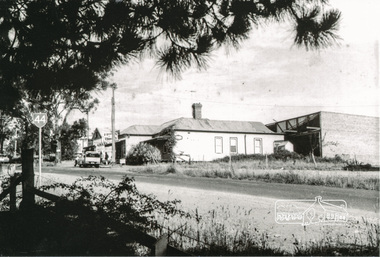
Photograph, Tom Prior, Doney's Store, Research
A much updated version of the store and house just prior to its removal.The Reynolds family were early settlers in Research. The Reynolds/ Prior collection of photographs were taken by Tom Prior, the maternal uncle of Ivy Reynolds, around 1900 and the 60 photos in the album give a fine overview of many of the landmarks of Research and Eltham over 100 years ago. lvy lived in the family home for many years at 106 Thompson Cres Research. Ivy's father, Ernst Richard Reynolds and grandfather, Richard Reynolds, lived at the same address. Ivy's father Richard worked for Mr. Trail on his property in Research. Reynolds Road is named after the family. Mr Tom Prior (wife Eva) worked at the Melbourne zoo. He was very innovative and made his own camera, using the black cloth hood to exclude the light. The photographs are a reminder of the rural nature of Research and Eltham and its rich heritage. Black and white photograph mounted in an album, the Reynolds/Prior Photograph Collection, this being one of 53 reproduced black and white images of early Eltham.The Reynolds/Prior Photograph Collection, Presented to the Eltham District Historical Society, 14 June 2006 by Ross McDonald. A second copy was also presented to the Andrew Ross Museum, Kangaroo Grounddoney property, eltham south, general store, ingrams road, main road, research (vic.), reynolds prior collection, shops, state route 44 -
 Eltham District Historical Society Inc
Photograph, Tom Prior, Blashik family home, Ingrams Road, Research
The Blashiks were a German family and friends of the Brinkkotters. The son was Len Blashik. The family had a rough time during the First World War. They made tanks.The Reynolds family were early settlers in Research. The Reynolds/ Prior collection of photographs were taken by Tom Prior, the maternal uncle of Ivy Reynolds, around 1900 and the 60 photos in the album give a fine overview of many of the landmarks of Research and Eltham over 100 years ago. lvy lived in the family home for many years at 106 Thompson Cres Research. Ivy's father, Ernst Richard Reynolds and grandfather, Richard Reynolds, lived at the same address. Ivy's father Richard worked for Mr. Trail on his property in Research. Reynolds Road is named after the family. Mr Tom Prior (wife Eva) worked at the Melbourne zoo. He was very innovative and made his own camera, using the black cloth hood to exclude the light. The photographs are a reminder of the rural nature of Research and Eltham and its rich heritage. Black and white photograph mounted in an album, the Reynolds/Prior Photograph Collection, this being one of 53 reproduced black and white images of early Eltham.The Reynolds/Prior Photograph Collection, Presented to the Eltham District Historical Society, 14 June 2006 by Ross McDonald. A second copy was also presented to the Andrew Ross Museum, Kangaroo Groundblashik family home, houses, ingrams road, len blashik, research (vic.), reynolds prior collection -
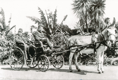 Eltham District Historical Society Inc
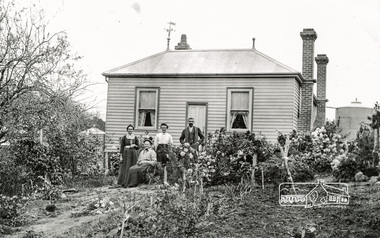
Photograph, Tom Prior, The Mosleys with donkey and cart, Ingrams Road, Research
At the top of the hill on Ingrams Road.The Reynolds family were early settlers in Research. The Reynolds/ Prior collection of photographs were taken by Tom Prior, the maternal uncle of Ivy Reynolds, around 1900 and the 60 photos in the album give a fine overview of many of the landmarks of Research and Eltham over 100 years ago. lvy lived in the family home for many years at 106 Thompson Cres Research. Ivy's father, Ernst Richard Reynolds and grandfather, Richard Reynolds, lived at the same address. Ivy's father Richard worked for Mr. Trail on his property in Research. Reynolds Road is named after the family. Mr Tom Prior (wife Eva) worked at the Melbourne zoo. He was very innovative and made his own camera, using the black cloth hood to exclude the light. The photographs are a reminder of the rural nature of Research and Eltham and its rich heritage. Black and white photograph mounted in an album, the Reynolds/Prior Photograph Collection, this being one of 53 reproduced black and white images of early Eltham.The Reynolds/Prior Photograph Collection, Presented to the Eltham District Historical Society, 14 June 2006 by Ross McDonald. A second copy was also presented to the Andrew Ross Museum, Kangaroo Grounddonkey, ingrams road, mosley family, research (vic.), reynolds prior collection -
 Eltham District Historical Society Inc
Photograph, Tom Prior, The two houses built by Richard Reynolds, Research
Ivy Reynolds' grandfather, Richard Reynolds built these two houses at Research. The house on the left remained in tact for many years. The Masons lived in the house at top right.The Reynolds family were early settlers in Research. The Reynolds/ Prior collection of photographs were taken by Tom Prior, the maternal uncle of Ivy Reynolds, around 1900 and the 60 photos in the album give a fine overview of many of the landmarks of Research and Eltham over 100 years ago. lvy lived in the family home for many years at 106 Thompson Cres Research. Ivy's father, Ernst Richard Reynolds and grandfather, Richard Reynolds, lived at the same address. Ivy's father Richard worked for Mr. Trail on his property in Research. Reynolds Road is named after the family. Mr Tom Prior (wife Eva) worked at the Melbourne zoo. He was very innovative and made his own camera, using the black cloth hood to exclude the light. The photographs are a reminder of the rural nature of Research and Eltham and its rich heritage. Black and white photograph mounted in an album, the Reynolds/Prior Photograph Collection, this being one of 53 reproduced black and white images of early Eltham.The Reynolds/Prior Photograph Collection, Presented to the Eltham District Historical Society, 14 June 2006 by Ross McDonald. A second copy was also presented to the Andrew Ross Museum, Kangaroo Groundhouses, mason family, research (vic.), reynolds prior collection, richard reynolds