Showing 1028 items matching "water river"
-
 Kew Historical Society Inc
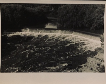
Photograph - Dight's Falls, 1920s
... on the Kew side of the river, which pumped water uphill... on the Kew side of the river, which pumped water uphill ...Dight’s Falls in Studley Park is an artificial weir built on a natural rock bar across the Yarra. The weir was built in the 1840s to provide water to the ‘Ceres’ flour-mill, one of the first in Victoria. The falls were later to become known as Dight’s Falls after the owners of the mill. Later, a pumping station was built on the Kew side of the river, which pumped water uphill to a reservoir in Walmer Street that provided water to the Melbourne Botanical Gardens and to Albert Park Lake. The area around Dight’s Falls was and is frequently used for recreational activities.One of a series of photographs, probably taken by Henry Christian of the Yarra River in Kew. An item from an outstanding and diverse photographic collection, assembled by members of the Christian and Washfold families of Kew.River Yarra at Dight’s Falls, Kew/Fairfield photographed from Kew bank.dight's falls, river yarra, christian-washfold collection -
 Kew Historical Society Inc
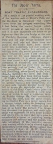
Newspaper - Article, The Upper Yarra: boat traffic endangered, 1918-20
An item of ephemera relating to tourism and recreation on the Yarra River in Melbourne in the first half of the twentieth century.An item from a large collection assembled by the Christian and Washfold families of Kew, including photographs, postcards, and ephemera. Many of the items in the Christian-Washfold Collection relate to the Yarra River and its use as as a recreational resource. Numerous items in the collection are historically important in that they are rare and often unique records of vanished locations or past recreational activities.Article describing the effects of the partial collapse of the weir at Dight’s Falls and its impact on water levels between Kew, Fairfield, and Heidelberg. The article is undated however as it describes Cr Harry Tompkins as Mayor of Kew it must date to the years 1918-20.christian-washfold collection, river yarra -- recreation, dight's falls -
 Kew Historical Society Inc
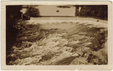
Photograph - The Race at Dight's Falls, 1925
... on the Kew side of the river, which pumped water uphill... on the Kew side of the river, which pumped water uphill ...Dight’s Falls in Studley Park is an artificial weir built on a natural rock bar across the Yarra. The weir was built in the 1840s to provide water to the ‘Ceres’ flour-mill, one of the first in Victoria. The falls were later to become known as Dight’s Falls after the owners of the mill. Later, a pumping station was built on the Kew side of the river, which pumped water uphill to a reservoir in Walmer Street that provided water to the Melbourne Botanical Gardens and to Albert Park Lake. The area around Dight’s Falls was and is frequently used for recreational activities.Original, black and white positive of water flowing over the 'Race' at Dight's Falls in MelbourneInscribed verso: "The Race at Dight's Falls / River Yarra Melbourne / 1.3.25" "Kodak Print"dight's falls, river yarra, yarra -- kew (vic.) -
 Kew Historical Society Inc
Photograph - Flooding of the Yarra Valley at Kew East, 1974
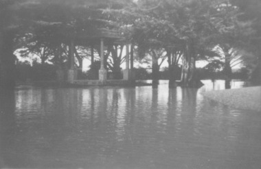
Flooding of the Yarra Valley, including that section of the Yarra bordering Kew and Kew East in the north and west of the municipality, was a regular occurrence. Extreme flood events of the Yarra River are recorded to have occurred in 1891, 1901, 1916, 1923 and 1934. The Municipality of Kew's response to these floods was to enact planning decisions restricting residential development in flood prone areas following the floods of 1916, 1921 and 1934. While floods continued after the development of the Upper Yarra Reservoir (construction 1948-57), the regularity and extent of these inundations diminished. During the nineteenth century, the land abutting the south side of the Yarra in Kew was devoted to dairy farming. In the twentieth century, before and after the construction of the Eastern Freeway, much of this low-lying area was used as golf courses and public parks.Late example of the capacity of the Yarra Valley at Kew to flood, even though drainage works and the Upper Yarra Reservoir had reduced their regularity.Original black and white print photograph of the low-lying land at East Kew under floodwater on 16 May 1974. The vantage point of the photographer is Lister Street. In the photo, the fences of the Kilby Farm can be seen. Flooding was caused by overflowing water in Glass' Creek and the River Yarra. Annotation verso: "Hay's Paddock op No.30 Lister Street / 16 May 1974 11.50am / R.L. 46.04"hays paddock, floods, yarra river, glass' creek, lister street -
 Kew Historical Society Inc
Photograph - Flooding of the Yarra Valley at Kew East, 1974
Flooding of the Yarra Valley, including that section of the Yarra bordering Kew and Kew East in the north and west of the municipality, was a regular occurrence. Extreme flood events of the Yarra River are recorded to have occurred in 1891, 1901, 1916, 1923 and 1934. The Municipality of Kew's response to these floods was to enact planning decisions restricting residential development in flood prone areas following the floods of 1916, 1921 and 1934. While floods continued after the development of the Upper Yarra Reservoir (construction 1948-57), the regularity and extent of these inundations diminished. During the nineteenth century, the land abutting the south side of the Yarra in Kew was devoted to dairy farming. In the twentieth century, before and after the construction of the Eastern Freeway, much of this low-lying area was used as golf courses and public parks.Late example of the capacity of the Yarra Valley at Kew to flood, even though drainage works and the Upper Yarra Reservoir had reduced their regularity.Original black and white print photograph of the low-lying land at East Kew under floodwater on 16 May 1974. The vantage point of the photographer is Lister Street. Flooding was caused by overflowing water in Glass' Creek and the River Yarra. Annotation verso: "Lister Street looking north / Flood level / 16 May 1974 11.30am / R.L. 46.04"hays paddock, floods, yarra river, glass' creek, lister street -
 Kew Historical Society Inc
Photograph - Flooding of the Yarra Valley at Kew East, 1974
Flooding of the Yarra Valley, including that section of the Yarra bordering Kew and Kew East in the north and west of the municipality, was a regular occurrence. Extreme flood events of the Yarra River are recorded to have occurred in 1891, 1901, 1916, 1923 and 1934. The Municipality of Kew's response to these floods was to enact planning decisions restricting residential development in flood prone areas following the floods of 1916, 1921 and 1934. While floods continued after the development of the Upper Yarra Reservoir (construction 1948-57), the regularity and extent of these inundations diminished. During the nineteenth century, the land abutting the south side of the Yarra in Kew was devoted to dairy farming. In the twentieth century, before and after the construction of the Eastern Freeway, much of this low-lying area was used as golf courses and public parks.Late example of the capacity of the Yarra Valley at Kew to flood, even though drainage works and the Upper Yarra Reservoir had reduced their regularity.Original black and white print photograph of Hay's Paddock under floodwater on 16 May 1974. The vantage point of the photographer is Keystone Crescent looking east. Flooding was caused by overflowing water in Glass' Creek and the River Yarra. Annotation verso: "Keystone Cr looking east / 16 May 1974 11.50am"hays paddock, floods, yarra river, glass' creek -
 Kew Historical Society Inc
Photograph - Flooding of the Yarra Valley at Kew East, 1974
Flooding of the Yarra Valley, including that section of the Yarra bordering Kew and Kew East in the north and west of the municipality, was a regular occurrence. Extreme flood events of the Yarra River are recorded to have occurred in 1891, 1901, 1916, 1923 and 1934. The Municipality of Kew's response to these floods was to enact planning decisions restricting residential development in flood prone areas following the floods of 1916, 1921 and 1934. While floods continued after the development of the Upper Yarra Reservoir (construction 1948-57), the regularity and extent of these inundations diminished. During the nineteenth century, the land abutting the south side of the Yarra in Kew was devoted to dairy farming. In the twentieth century, before and after the construction of the Eastern Freeway, much of this low-lying area was used as golf courses and public parks.Late example of the capacity of the Yarra Valley at Kew to flood, even though drainage works and the Upper Yarra Reservoir had reduced their regularity.Original black and white print photograph of the low-lying land at East Kew under floodwater on 16 May 1974. The vantage point of the photographer is Lister Street. Flooding was caused by overflowing water in Glass' Creek and the River Yarra. Annotation verso: "Lister St looking same as No.3 / 16 May 1974 11.30"floods, yarra river, glass' creek, lister street -
 City of Warrnambool Rowing Club
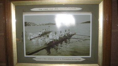
Photograph, The Final for Mrs Rolfe's Trophy
Mrs George Rolfe was the wife of the owner of Lyndoch. He was a Melbourne tea merchant, who owned 216 acres of the Shipley estate further up the Hopkins River. In the late 1870s he bought 2 acres of land and house along the Hopkins near the bridge and developed into Lyndoch. By 1883 he increased to 50 acres. He resoiled the land, put in a water supply reservoir, water tanks and pumps, a reticulation system and a windmill- 50 feet high with four sails 18 feet high and 4 1/2 wide. George Rolfe died in 1919 and the present Lyndoch House was built in 1925. Source: By These We Flourish, A History of Warrnambool by C.E. Sayers and P.L. Yule Edition 1 A4 landscape black and white photograph of a mens rowing four on the Hopkins River, Warrnambool.The Final for Mrs Rolfe's Trophy Presented by Mrs George Rolfe by W.R.C.lyndoch, lyndoch warrnambool, city of warrnambool rowing club, warrnambool rowing club, george rolfe -
 8th/13th Victorian Mounted Rifles Regimental Collection
Photograph
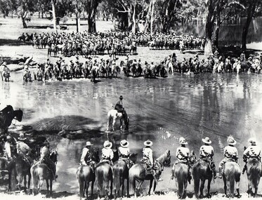
A rare photograph of massed Light Horse in Victoria shortly before mechanisation consigned the horse to history.Black and white photograph of large group of horsemen in ranks waiting in the process of watering horses at a lagoon. One copy of the image claims it to be 8th Light Horse Regiment watering horses at a Murray River lagoon, South Corowa NSW, September 1939; Wahgunyah Troop, C Squadron - this side of lagoon, Lieutenant J. Nott on grey horse in water. A second copy (Cat No 0690) asserts it is 4 regiments of light horse being 8th, 13th, 20th and 4th watering horses near Torquay Victoria, March 1940.On a label on reverse of 0690: "Picture taken about March 1940 when the 13th Light Horse from Gippsland, the 8th Light Horse from Upper Murray, the 4th Light Horse from the Western Districts and the 20th Light Horse from the Goulburn Valley were in camp near Torquay. Mr Cappur Webb of Glendoxey, Seymour, a member of the 20th said the picture must have been taken during and exercise about five miles north of Torquay. “We used to water our horses in that lake”, he said." -
 8th/13th Victorian Mounted Rifles Regimental Collection
Photograph
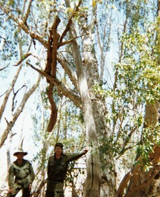
In 1988, as part of a Defence of Mainland Australian policy, defence of facilities of strategic importance in northern Australia were allocated to Army Reserve units. ‘A’ Squadron was allocated the defence of Tindal Air Force base located 15 KM outside Katherine in Northern Territory. Consequently the Squadron deployed on Exercise ‘Northern Explorer’ to gain first-hand knowledge of operating conditions for mounted and dismounted patrolling in the area.Colour photograph of Captain C. Carrington, earing hat, and Sergeant Koschel of ' A ' Squadron 8/13 VMR during Exercise " Northern Explorer." Flood debris caught high in tree branches indicate water level during wet season on Ferguson River, Northern Territory. -
 Sunbury Family History and Heritage Society Inc.
Photograph, River studies
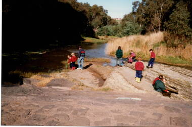
... to study some of the river life inn the local water course. Bulla ...Students from Bulla Primary school were taken to the nearby Deep Creek to study some of the river life inn the local water course.Bulla township is situated in the Deep Creek valley and was an ideal place to take students to study river life close to their school.A coloured photograph of eight children with two adults standing on a rocky outcrop beside a river and looking at the riverlife in the water.rivers, deep creek, river studies, bulla, bulla primary school -
 Sunbury Family History and Heritage Society Inc.
Photograph
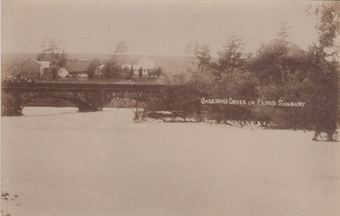
The post card is a record of a time when the Jacksons Creek flooded and the water almost reached the two arches on the Macedon Street Bridge. The Goonawarra Winery buildings can be seen in the back ground.A sepia photograph in post card format of a river in flood with the water almost reaching the two arches on the stone bridge. Farm buildings can be seen in the middle distance.JACKSON'S CREEK IN FLOOD SUNBURYmacedon street bridge, jacksons creek, goonawarra winery -
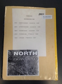 Stawell Historical Society Inc
Book, Stawell Historical Society, North to Nowhere - The Wimmera River, 2002
stawell water -
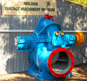 Maldon Vintage Machinery Museum Inc
Pump - Centrifugal, Approximately 1954
... water from the Murray river to irrigate the fruit blocks ...This pump was situated at Mildura Victoria and pumped water from the Murray river to irrigate the fruit blocks.Large double suction centrifugal pump with 36" suction and discharge branches weighing 7500 kg. Cast iron baseplate for the pump measuring 154 x 185 x 22 cm. The pump is fitted with a spring grid coupling. The pump and baseplate are painted pale blue. The pump identification plate has been removed and there are no markings cast on it. The baseplate has Thompsons cast in relief on the top surface. The coupling has a brass nameplate with Richardson Spring Grid Coupling engraved on it.machinery - pumps; metalwork -
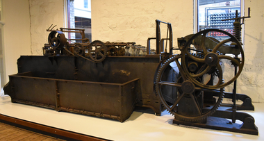 National Wool Museum
Machine - Scouring Bowl, J Dyson & Sons Pty Ltd, c.1890
Scouring is the process that removes wool wax and other unwanted products from wool. Wool is washed in a hot detergent solution. It moves through a series of scouring bowls and is then rinsed and dried. Careful handling and washing preserves the strength and softness of wool. If the wool contains lots of seeds and other vegetable matter, it must be cabonized. This means it is treated with a solution of sulpheric acid and then baked at high temperature to remove impurities. The disused scouring water left-over from this process was often let drain into rivers and watercourses causing pollution. Many of Geelong's wool scours along the Barwon River were closed due to environmental damage. The race system on this bowl is not the original it has been modified with a variation of the harrow system. Used at E.P. Robinson South Geelong from c.1890-1970.Scouring bowl.J. Dyson & Sons Pty Ltd, Geelongsouring bowl, j dyson & sons, geelong, wool processing, e. p. robinson, textile industry, factory, mill -
 Montsalvat
Photograph, Untitled (Indigenous Man), 1960
Black and white photograph of an indigenous man seated on the river bank with his image reflected in the water. Signed in pencil (Ll) '1/10' (Lc) 'Matcham Skipper' and dated (Lr) 'circa 1960' on matt boardmatcham skipper, photograph, indigenous, male -
 Federation University Art Collection
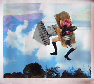
Work on paper - Photocollage, 'Being Ultra Light' by Rochelle Summerfield
Rochelle SUMMERFEILD Born Sydney, Australia This item is part of the Federation University Art Collection. The Art Collection features over 2000 works and was listed as a 'Ballarat Treasure' in 2007.Artists Statement: I am based in Northern NSW. My art practice is deeply influenced by my connections and experiences with the rivers and habitat where I live. Through drawing, paint, collage and digital media my work explores human relationships with riparian environments. Every day I see the undeniable beauty of our rivers as well as the ecological suffering of these riparian landscapes. Historical practices of land clearing, water politics and weed infestation put tremendous pressure on the Australian ecology. Disrupting traditional art forms, I combine them with new technologies to reveal some of the complexities behind human relationships with nature. With bold collagist experimentation, I combine numerous mediums to expose the small revelations between media. These juxtapositions open up the possibilities of reinventing different ways of being with the natural environment. Like the layers in my work, the issues surrounding our riverine environments are multifaceted and complex and begin with individual choices. I want to direct people’s attention to our rivers, to love, appreciate and reconnect with the natural environment. Human experience with nature is a fundamental part of our sense of self, health and well-being as well as community connection. (https://rochellesummerfield.com/about/, accessed 10 June 2020)art, artwork, rochell summerfield, printmaking, print council of australia -
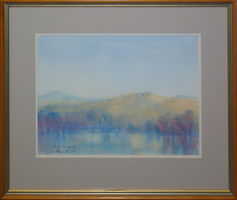 Federation University Art Collection
Painting, 'Murray River Flood Plain', by David Alexander, 2004
David ALEXANDERFramed watercolour landscape depicting water in the foreground and mountains in the mid-ground.Signed and dated in ink lower left "DA Alexander '04"art, artist, david alexander, murray river, gippsland campus, landscape, watercolour, churchill -
 Port Fairy Historical Society Museum and Archives
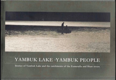
Book, Glenelg-Hopkins Catchment Management Authority, Yambuk Lake Yambuk people : stories of Yambuk Lake and the catchments of Eumeralla and Shaw Rivers, 2008
This title explores the complex relationships between the people and the place of Yambuk; the value of local knowledge and tells the stories of the Yambuk Lake, wetlands, rivers and catchment. Historic records and photographs are combined with the recollections of more than 20 people who know the lake.vi, 207 pages : colour illustrations, maps. ; 21 x 30 cm. Includes bibliographic references. non-fictionThis title explores the complex relationships between the people and the place of Yambuk; the value of local knowledge and tells the stories of the Yambuk Lake, wetlands, rivers and catchment. Historic records and photographs are combined with the recollections of more than 20 people who know the lake.baxter, annie maria, 1816-1905., water quality management -- victoria -- yambuk lake., settlement and contacts - settlers., animals - fish - eels., gunditjmara / gurndidy / dhaurwurd-wurrung people (s20) (vic sj54-11), yambuk (vic.) -- social conditions., yambuk (vic.) -- history., yambuk lake (vic.), yambuk (w vic sj54-11), deen maar / lady julia percy island (w vic sj54-11), eumeralla (w vic sj54-11), peek wurrung people, book -
 Port Fairy Historical Society Museum and Archives
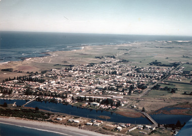
Photograph
... moyne river douglas house railway water tower traffic bridge ...Aerial-Port Fairy 1972Coloured aerial photograph aerial, moyne river, douglas house, railway, water tower, traffic bridge, pedestrian bridge -
 Port Fairy Historical Society Museum and Archives
Photograph
1946 was the year of the biggest flood experienced in Port Fairy. This photograph shows evidence of the inundation at the Port Fairy Cemetery situated at the West of the townBlack and white photograph of headstones surrounded by waterflood, river, 1946, headstone -
 Port Fairy Historical Society Museum and Archives
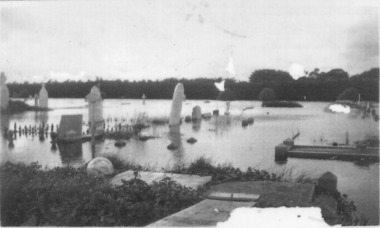
Photograph
Showing the flood waters of 1946 around the Band Rotunda in the botanical gardens. Funding for the construction of the Rotunda was bequeathed in the Will of local resident Mrs Annie Williams, who was born in Daylesford in 1872 and died in Kew in 1930. Annie’s Will stipulated that the remaining value of her Estate be spent on erecting a Bandstand in the Port Fairy Botanical Gardens dedicated to the memory of her brother Hugh, a stretcher bearer in WW1 and who died in 1921 after being discharged with health issues, her husband Henry, and herself naturally. There is a plaque dedicated to Annie on the Bandstand She requested that the Bandstand be a replica of the one at Daylesford but by 1933 the value of her Estate had diminished to £76.4/8 which was insufficient to cover a similar design and the Borough Councillors felt it would be too extravagant for the Port Fairy Botanical Gardens. Local builder J.J.McLaren’s tender of £71.15/- was accepted and the octagonal concrete pillared construction was completed with the use of sustenance labour the following year. The Bandstand was opened in December, 1934 with a performance by the Port Fairy Band and local residents enjoying the entertainment and a picnic. In 1934 it was reported that there was some fuss in Council because of the whereabouts of the sum of approximately £3/- , being the amount left over from the build. After some months of debate, in which the Councillors suggested that the Engineer had used the money inappropriately, and to which he responded that the build had cost more than the quote, the matter seems to have ended there An image of the flood waters in the botanical gardens in 1946Black and white photograph of Flood water around rotunda in the gardensflood, river, botanical gardens, port fairy, moyne river, rotunda, bandstand -
 National Communication Museum
Photograph (item) - Floodwater pole repair, Sydney Press, June 1952
Postmaster-General's Department telegraph linesman, Chris Byrnes, received a British Empire Medal for bravery and devotion to duty for his response to the flooding at Darlington Point, New South Wales, in June 1952. As E Henderson, then Acting Director of Posts and Telegraphs recalled, the town's "communication lines were menaced by floodwaters" when the nearby Murrumbidgee River flooded. In order to retain communication to the town, Chris Byrnes, a Postmaster-General's Department employee of over 13 years, acted in the "best traditions of the service" (E Henderson). An eye witness, recorded in the Murrumbidgee Irrigator newspaper on June 27 1952, described Byrne’s efforts: "An interesting incident was witnessed when a Leeton post office linesman swam through flood waters to reach a telegraph post which had been washed out by the flood…With a rope tied around his waist, one end of which was held by other members of the linesmen's gang, Chris Byrne swam through the flood water…to release the trunk lines from the post." An eye witness, recorded in the Murrumbidgee Irrigator newspaper on June 27 1952, described Byrne’s efforts: "An interesting incident was witnessed when a Leeton post office linesman swam through flood waters to reach a telegraph post which had been washed out by the flood…With a rope tied around his waist, one end of which was held by other members of the linesmen's gang, Chris Byrne swam through the flood water…to release the trunk lines from the post."darlington point, murrumbidgee river, pmg, postmaster-general, linesman, flooding, natural disaster, emergency -
Mansfield Historical Society
bottle, F Wheeler
This item was found on the site of F Wheeler's cordial factory in Chenery Street Mansfield which was in operation in 1891.Water was carted from Devil's River and stored in a 28,000 gallon tank. Mr Keane was the manager.As cordial factories are no longer in use in Mansfield this broken bottle has historic significance and it is aesthetically pleasing because of the many colours which can been seen in the green glass'Green glass cordial bottle with torpedo base - broken -
 Port Fairy Historical Society Museum and Archives
Photograph, Cr J Ritchie Shire of Belfast President1866-67 1869-70
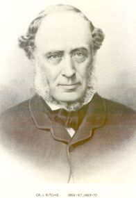
Cr J Ritchie came from Scotland at Hobart in 1833 having been 9 months on the outward journey. he took up land at South Esk and remained there for 6 years.later on advice of the Henry brothers he came to Victoria and after a preliminary inspection of the land charted the brig “William” and with all of his possessions, including 2000 sheep and two servants he arrived in Portland Bay in January 1840 and as he already held a squatting licence No 230 became a settler in the district. he moved along the coast toward Goose Lagoon but due to a drought the water had dried up and forced him to move further eastward to the Upeer Hopkins but the lack of any but brackish water he was forced to return to Aringa. Aringa comprised of 26,000 acres between the Shaw and Moyne Rivers, 640 acres became freehold at one pound and acre with the right to take up leasehold at a low rate according to the number of stock. At Aringa he designed and built his first home part of which still stands today. He married Sarah Elizabeth Davis in 1852 at Weerongurt Station (Mr John Cox’s property). Mrs Ritchie died in 1920. he was elected Shire of Belfast President for the periods of 1866-67 and 1869-70 John had originally chosen to practice law as his vocation in Scotland but abandoned law for the open air life and died at the age of 86 years in 1887 elected Shire of Belfast President for the periods of 1866-67 and 1869-70Black and white portrait photograph Cr J Ritchie 1866-67 1869-70belfast, president, council, portrait, government, shire, municipal, local-government -
 Melton City Libraries
Newspaper, James Pinkerton, 1991
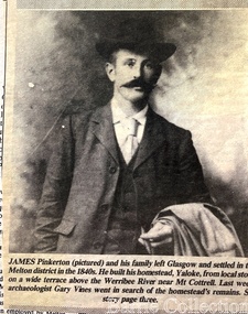
"James Pinkerton, described by fellow settler Isaac Batey as ‘a fine old Scotish [sic] gentleman’, and his wife Margaret established ‘Chamois Ponds’ on Kororoit Creek in the Keilor district in 1840.44 After a fire in 1848, the Pinkerton family moved further west to a holding called Yaloke, on the Werribee River in the Melton district.45 Today, the Surbiton Park water treatment plant operates on part of the Yaloke run. The Pinkerton family is remembered in Melton in part due to the historic graves of the original settler, Margaret Pinkerton, and four of her grandchildren, which were marked by a memorial cairn in 1931. Changes to sewage flood zoning in the area in the 1990s necessitated that these burials be relocated. Members of the Melton & District Historical Society oversaw a project to relocate the Pinkerton graves and cairn 200 metres from their original site to their current resting place at Mount Cottrell. This relocation ceremony took place on 8 November 1992, with the participation of local school students and with Pinkerton descendants playing a central role. This occasion also marked the opening of the Pinkerton Forest Project, which saw 50 hectares of degraded woodland in Surbiton Park protected for regeneration".Photograph of Jame Pinkerton featured in the the Telegraphlocal identities, pioneer families -
 Melbourne Legacy
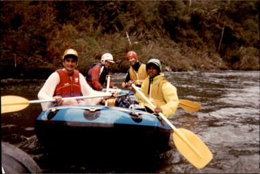
Photograph - Junior legatee outing, Rafting the Thomson River, 1993
Legacy have many programs to send young junior legatees on activities, camps and outings. The photos shows junior legatees on a white water rafting trip on the Thomson River in 1993. It was stored with other photos of Junior Legatees from the 1980s and 1990s. A record of a Legacy providing experiences for the junior legatees.Colour photo x 5 of junior legatees white water rafting in the Thomson River.Hand written on back in blue ink: 'Junior Legacy Thomson River Rafting. Nov 13/14 1993'junior legatee outing, rafting, river -
 Melbourne Legacy
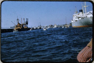
Slide, Operation Float 1957, 1957
A colour slide small boats on the Yarra River or Port Philip alongside larger moored boats in 1957. Operation Float was an event run by Melbourne Legacy to take Junior legatees on an outing. It could have been to naval boats such as HMAS Cerberus or to a Yacht club. It gave the junior legatees the opportunity to see a naval boat in action, spend time on the water or try sailing. In 1957 it appears to be several smaller boats taking small groups of children out on the bay. Was with many other slides taken in the 1950s and 1960s. The slides have been photographed to make digital images and moved to archive quality sleeves. In many cases the original images were not well focussed and the digital image the best available.A record of outings being organised for children.Colour slide of 5 or 6 small boats on the Yarra or bay in a red edged Kodachrome cardboard mount.Printed on reverse in red ink 'Kodachrome Transparency / Processed by Kodak'. Handwritten in blue ink 'A new view of Melb / 24 / 1957'. Imprinted in black ink '18'operation float, junior legatee outings -
 Melbourne Legacy
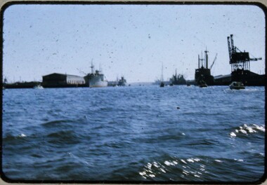
Slide, Operation Float 1957, 1957
A colour slide small boats on the Yarra River or Port Philip alongside larger moored boats in 1957. Operation Float was an event run by Melbourne Legacy to take Junior legatees on an outing. It could have been to naval boats such as HMAS Cerberus or to a Yacht club. It gave the junior legatees the opportunity to see a naval boat in action, spend time on the water or try sailing. In 1957 it appears to be several smaller boats taking small groups of children out on the bay. Was with many other slides taken in the 1950s and 1960s. The slides have been photographed to make digital images and moved to archive quality sleeves. In many cases the original images were not well focussed and the digital image the best available.A record of outings being organised for children.Colour slide of small boats on the Yarra or bay in a red edged Kodachrome cardboard mount.Printed on reverse in red ink 'Kodachrome Transparency / Processed by Kodak'. Handwritten in blue ink 'Heading up river / 22 / 1957'. Imprinted in black ink '19'operation float, junior legatee outings -
 Melbourne Legacy
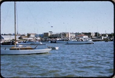
Slide, Operation Float 1957, 1957
A colour slide small boats on the Yarra River or Port Philip in 1957. Operation Float was an event run by Melbourne Legacy to take Junior legatees on an outing. It could have been to naval boats such as HMAS Cerberus or to a Yacht club. It gave the junior legatees the opportunity to see a naval boat in action, spend time on the water or try sailing. In 1957 it appears to be The Royal Victorian Motor Yacht Squadron using several smaller boats taking small groups of children out on the bay. Was with many other slides taken in the 1950s and 1960s. The slides have been photographed to make digital images and moved to archive quality sleeves. In many cases the original images were not well focussed and the digital image the best available.A record of outings being organised for children.Colour slide of small boats on the Yarra or bay in a red edged Kodachrome cardboard mount.Printed on reverse in red ink 'Kodachrome Transparency / Processed by Kodak'. Handwritten in blue ink 'RVMYC who gave us Operation Float / 26 / 1957'. Imprinted in black ink '20'.operation float, junior legatee outings