Showing 25228 items matching " north"
-
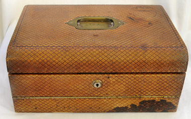
 8th/13th Victorian Mounted Rifles Regimental Collection
Photograph - Born digital image
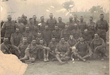
8th Australian Light Horse Regiment was raised following Federation from companies of the Victorian Mounted Rifles in North East Victoria. It was an all volunteer force of citizen soldiers. The annual encampment, usually conducted over the Easter break, was the culmination of training conducted in local areas throughout the year. Study of citizen soldiers in first decade following FederationDamaged black and white photograph of group of soldiers of the 8th Light horse Regiment at Seymour 1908.Seymour 1908. / Sgt W Luscombe 2nd right centre row. / Holder of the Local Forces Victoria Long Service and / Good Conduct Medal, also holder of the Colonial Forces / Long Service Medal. / Donated by I Errey Baddaginnie.seymour, light horse, luscombe -
 Melbourne Legacy
Letter - Document, letter, 1943
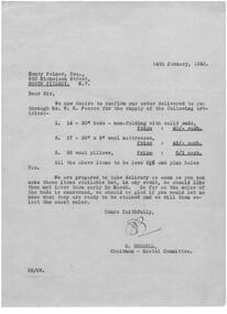
Letter dated 14 January 1943 to Henry Palmer of 650 Nicholson St, North Fitzroy to place an order for 14 beds, 17 mattresses and 36 pillows for the hostel. It states the costs and that the items were to be discounted 2.5% and plus Sales Tax. Delivery was to be no later than the end of March.A record of prices and quantities of furniture and items required for the first hostel established by Legacy in 1943 during the war.Green quarto copy paper, black type, two hole punched.Initialled for E. Russell, Hostel Chairman.holmbush administration, residences -
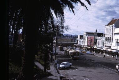
 Ballarat Tramway Museum
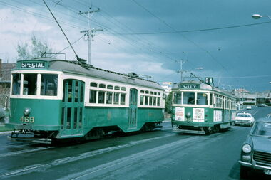
Photograph - Digital Image, Greg Triplett, Tramway signage at Lydiard St Nth terminus, 19-9-1971
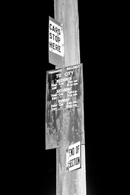
Tram stop signs on a pole at the Lydiard St North terminus - comprising a "Cars Stop Here", timetable board giving first and last cars for Weekdays, Saturdays and Sundays and an End of Section sign. Taken on the last day of operation of the SEC Ballarat tramway system - 19-9-1971. Yields information about tram stop signage at Lydiard St North.Digital image - 120 negative tramways, tramcars, ballarat, last day, closure, lydiard st north, tram stops, signs -
 Sunbury Family History and Heritage Society Inc.
Photograph, 25th July 1986
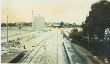
Heavy snow fell across Melbourne and surrounding suburbs, including Sunbury, on 25th July 1985. The photograph taken from the pedestrian bridge at Sunbury Railway Station is looking north to the historic Macedon Street bridge. The widespread snow across the metropolitan area on that day caused much chaos.A coloured photograph of widespread snow across a railway line and the surrounding area.sunbury railway station, extreme weather events, snow storms -
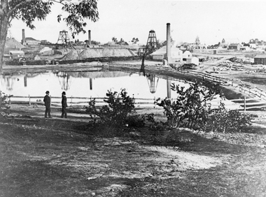 Stawell Historical Society Inc
Photograph, The Pleasant Creek Cross Reef No1 Shaft Panorama of a Mining Scene in the Duke Sands area c1875
Mining Scene Duke Sands area c1875 Behind the tree on left is Extended Cross Mine and on the right is the Oriental Mine. In the centre is the North Cross Mine No1 shaft. In the foreground is one of the Moonlight dams. St Peters Lutheran Church in Scallan Street can be seen on the right horizon. Two mines and workings on other side of Moonies settling dam. Two Gentlemen lower left cornerstawell mining -
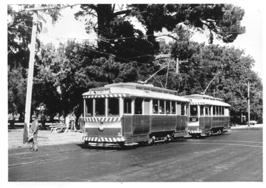
 Ballarat Tramway Museum
Photograph - Bendigo tram 12, 1950s
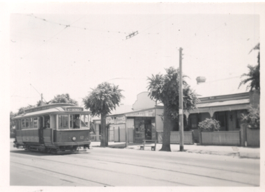
Photograph of Bendigo Tram 12 with a North Bendigo destination, leaving at a tram stop. Has a shop in the background. Photographer unknown, 1950s given the colour scheme. Tram ex Melbourne No. 107 sold to SEC in 1935, as Ballarat 19, swapped with Bendigo during 1960 and became Bendigo 12. Yields information about Bendigo tram 12.Photograph, black and white on plain paper.tramways, trams, bendigo, tram 12, north bendigo -
 Eltham District Historical Society Inc
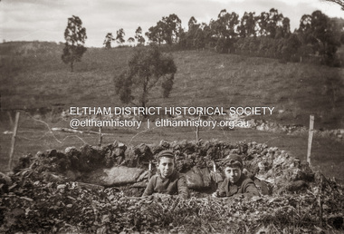
Photograph, Charles Withers (aka Bill) and his friend Mervyn Britain (right) in their trench at Southernwood, Eltham, 1916
Charles Withers (aka Bill) with his good friend from school, Mervyn Britain with mock trenches and rifles at the Withers family home, Southernwood, Eltham. The view is possibly looking to the north [Charles son, John Withers explained that his father and friend liked to play war games.]Many items in this collection have suffered from significant water damage and black mouldjohn withers collection, eltham, 1916, southernwood, trenches, scan - 620 format 6x9 negative, charles meynell pitt withers, mervyn britain -
 Sunbury Family History and Heritage Society Inc.
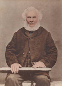
Photograph, John Cruikshank Studios, George Evans
George Evans is the man in the photograph. He arrived in Hobart from England on 1st September 1825 and later came to Victoria in 1836.With a flock of sheep he squatted on land along the Jacksons Creek valley north of Sunbury and built his homestead (known as Emu Bottom) on his holding.George Evans was one of the first European Settlers to take up land along the Jacksons Creek in Sunbury.A non-digital sepia studio photograph of a bearded man sitting on a chair and holding a telescope across his lap.The photograph is mounted on cream cardboard.george evans, emu bottom, squatters -
 Ballarat Tramway Museum
Photograph - BTPS trams at Gardens Loop, late 1970s
The photograph shows BTPS-operated tram No. 14 and possibly No. 27 at Gardens Loop heading north to St Aidans Drive. The second tram is carrying a "Tram Rides" sign. Photo the mid to late 1970s given the large trees behind which were later removed. Photographer unknown. Yields information about BTPS operations in the late 1970s and Gardens Loop.Black and white print - plain back. Two copies held.tramcars, tramways, btps, tram 14, gardens loop, wendouree parade -
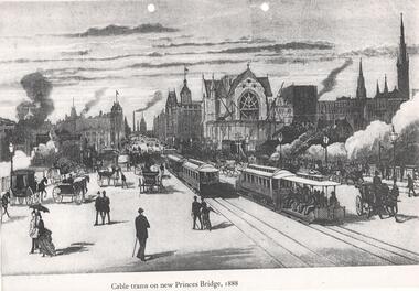 Melbourne Tram Museum
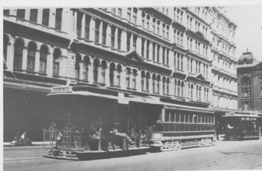
Photograph, "Cable trams on new Princes Bridge, 1888", 1885
Illustration on an A4 sheet of cable trams and other vehicles travelling over Princes Bridge, 1888. Has St Paul's Cathedral under construction and extensive smoke from steam locomotives travelling under the bridge. Looks north along Swanston St. Photo print also held.Demonstrates an artists view of a busy scene of Princes Bridge.Photocopy and black and white print. Two copies held.trams, tramways, princes bridge, swanston st, cable trams -
 Melbourne Tram Museum
Postcard, "Collins Street West", c1905
Image shows a view of Collins St West from ? street. Has a Victoria Bridge cable tram in the view. Buildings marked are Baylee & Co, Life Insurance Co., North British & Mercantile Insurance Co, Hicks Atk? Moubray - Draper. Based on date on the rear of the card 1905.Yields information about Collins St West c1905 and the nature of dress of the many men in the photo.Colour postcard - Divided back, titled "Collins Street West" with a tape boarder on the rear with pencil notes.In pencil "SPF/Melbourne - Streets - Collins Street West c1905". price of 6E and rubber stamp imprint in one corner.collins st, postcards, victoria bridge, cable trams -
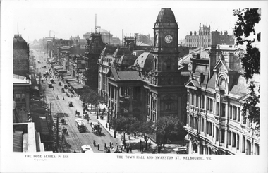 Melbourne Tram Museum
Postcard, Rose Stereograph Co, "The Town Hall Swanston Street Melbourne", c1900
Rose Series postcard No. P 588 titled "The Town Hall Swanston Street Melbourne", looking north along Swanston St. Has at least eight cable tams in the view, along with many horse-drawn vehicles. The building on the right is the Queen Victoria Building on the corner of Collins Street. Yields information about Swanston St and the Melbourne Town Hall, c1900Postcard - printed real photograph with Rose Stereograph Co. name on the rear.trams, tramways, swanston st, cable trams, melbourne town hall, collins st -
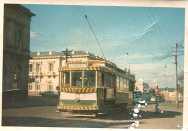 Ballarat Tramway Museum
Photograph - Tram 33 City Centre, Maureen van Rooy, c1971
Photograph shows Ballarat No. 33 at the City Centre stop, c1971. Tram has the destination of Lydiard St North and has a one man sign in the back cabin. The short tram stop pole is alongside. In the background is the ANZ bank, the Post Office and in the far distance the Big W store.Yields infomation about tram 33 and the City Centre stop.Colour print with plain back.tramcars, tramways, sturt st, lydiard st, tram 33, post office, city centre -
 Melbourne Tram Museum
Slide - Y 469 & SW6 965 Hawthorn Road, Warren Doubleday, 2-10-1971
Set of two photos of Y class 469 on a tour in Hawthorn Road, East Brighton. The first is taken near the terminus of route 64, with SW6 965 northbound, and the second at the intersection with North Road, with a Post Office and a milkbar in the view, advertising Cambridge cigarettes. Dated 2-10-1971.Yields information about the use of Y469 on tours and Hawthorn Road.Set of two Kodachrome cardboard mounted slides.tramways, tramcars, y class, tram 469, sw6 class, tram 965, hawthorn road, east brighton -
 Melbourne Tram Museum
Photograph - Departing Elizabeth Street Terminus, c1928
Photograph shows a Dummy and bogie trailer car departing Flinders Street terminus in Elizabeth Street while a North Melbourne Dummy is shunted in the background. Several multi storey buildings along Elizabeth Street and a glimpse of Flinders Street Railway Station are also shown. D O'Brien CollectionYields information about Elizabeth Street terminusBlack and white photograph with note on rearIn ink "19" and "K McC"tramcars, tramways, cable trams, dummy, grip car, terminus, elizabeth street, flinders street, flinders street station, north melbourne, shunt -
 Bendigo Military Museum
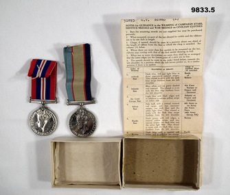
Award - MEDALS, BOXED WW2, Post 1945
"Charles Thomas Biggs" No. 51893 RAAF. Enlisted 16/3/42 aged 31. Discharged 8/11/45 at rank of Sgt in HQ North Eastern Area. Born 1911. Died 1 Dec 1962, at Quarry Hill, Vic, aged 51. Buried at Bendigo Cemetery.1. War Medal 1939-1945. 2. Australian Service Medal 1939 - 45. 3. Instructions on Guidance of how medals are to be worn on civilian clothes. 4. White box bottom. 5. White medal box top.1. Inscribed with George VI and Lion over a fallen Eagle. 2. Inscribed Aust. Service Medal 1939-45 with Commonwealth Emblem and George VI on other side. 3. Stamped 1966 & RAAF medal Section, Vic Barracks, Melbourne.charles thomas biggs, raaf, ww2, australia service medal, war medal 1939-45 -
 Sunbury Family History and Heritage Society Inc.
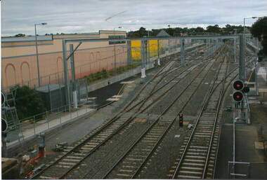
Photograph, Sunbury Railway Station, 2012
This is a photograph of the Sunbury Railway Terminal, looking north, taken shortly after the rail service became electrified in 2012. Prior to this date, Sunbury residents relied on the V Line service for their commute to Melbourne. The commercial development on either side of the rail tracks gradually took place from 2000.A coloured photograph of a railway yard with extra rail tracks lines and the overhead electric lines. There is commercial development on either side of the rail tracks.sunbury railway station, electricity, metro train service, sunbury -
 The Beechworth Burke Museum
Geological specimen - Chalcopyrite
This specimen originated from Mount Lyell on the west coast of Tasmania, where a large group of open cut and underground copper-silver-gold mines began operating in 1883. Between 1893-1994, the Mt Lyell Mining and Railway Company were responsible for operations. The Mt Lyell copper-gold mines produce some excellent crystallised specimens of chalcopyrite and other minerals. The deposits are generally considered to be of Cambrian volcanic origin, but there are indications of Devonian granitic influence on the ores, plus local remobilisation during Devonian deformation. Over 120 million tonnes of ore was produced from several workings, including the main Prince Lyell mine and the North Lyell mine, which was also of great importance. The Mount Lyell mines have a long history of human and environmental disasters, including the 1912 North Lyell fire that killed 42 miners, and two separate incidents in 2013 in which three people lost their lives. The environmental impacts from this complex of mines are extensive, with waste tailings and heavy metal contamination flowing directly into the King and Queen River catchments. In 1954, the eminent Australian historian, Geoffrey Blainey, published 'The Peaks of Lyell' which delves into the history of the 1912 North Mount Lyell Disaster.Chalcopyrite does not contain the most copper in its structure relative to other minerals, but it is the most important copper ore since it can be found in many localities and occurs in a variety of ore types. The brassy-yellow colours in Chalcopyrite mean it is often confused with pyrites and gold, leading to use of the term, "fool's gold." Chalcopyrite has been the primary ore of copper since smelting began five thousand years ago. This specimen is part of a larger collection of geological and mineral specimens collected from around Australia (and some parts of the world) and donated to the Burke Museum between 1868-1880. A large percentage of these specimens were collected in Victoria as part of the Geological Survey of Victoria that begun in 1852 (in response to the Gold Rush) to study and map the geology of Victoria. Collecting geological specimens was an important part of mapping and understanding the scientific makeup of the earth. Many of these specimens were sent to research and collecting organisations across Australia, including the Burke Museum, to educate and encourage further study.This hand sized solid mineral specimen has shades of brass-yellow with spots of iridescent green-black tarnish. Chalcopyrite is a copper iron sulphide mineral and a major ore of copper common in sulphide veins and disseminated in igneous rocks. Chalcopyrite has a hardness of 3.5-4 on the Mohs Scale. It is a member of the tetragonal crystal system and has metallic lustre and opaque transparency.burke museum, beechworth, indigo shire, beechworth museum, geology, geological specimen, chalcopyrite, copper pyrites, copper mining, tasmanian geology, mount lyell, mount lyell mines, fools gold, mohs scale, crystals, minerals, historical geological collection, victorian geological survey, a.r.c selwyn, gold rush, van diemans land -
 Orbost & District Historical Society
black and white photographs, 1980s? (winter months)
All photographs seem to have been takenfrom the Telecom tower on the corner of Browning and Wolseley Streets in Orbost 3259.1 is a view of the Orbost township looking north-east. The swimming pool and bowling club can be seen in the foreground. 3259.2 is aview looking north-west and showing the tennis courts and clubhouse, the Recreation Reserve oval, the Youth Centre, Historical Museum, Municipal Offices, Senior Citizens clubrooms with the fire station in the foreground. 3259.3 is a view looking south with the Shire of Orbost Municipal offices and Ruskin Street in the foreground. Munro Street can be seen running from Ruskin Street to St Joseph's School in the middle distance. Lochiel Park oval, Lochiel House, the Snowy River and highway bridge are in the background. 3259.4 is a view looking south showing the Club Hotel, C.B.C. Bank in the middle distance and Hoffman's paddock (Forest Park) and the Snowy River beyond. 3259.5 is a view looking north-east over houses. 3259.6 is aview over the main street, Nicholson Street.showing the main shopping precinct. Shop signs for Permewans, Williams Shoes, F.B. Dicken and Orbost Bakery can be seen. 3259.7 is a view looking south west and shows Forest park and beyond towards Bete Bolong.These photographs are detailed pictorial records of the township of Orbost.Seven black / white photographs taken from above a township. Chimney smoke can be seen in the photographs.orbost-township-1980s aerial-photograph-orbost -
 Ballarat Tramway Museum
Slide - Set of 9, Warren Doubleday, Ballarat - last weekday of full operations, 20/8/1971
Photos taken on the last weekday of full operations by the SECV in Ballarat prior to the first closure of the Victoria St line on 22/8/1971. 1 - trams 33, 13, 30, and 12 in the City loop. Has the Dickins food store, Thomas Jewellers, Gear Chemist, Patersons stores in the view. 2 - tram 37 running a Special passing the trams above in the City Loop. Also has the Hartley's and the T& G buildings in the view. 3 - tram 27 descending the Lydiard St hill about to pass the Titanic Bandstand. 4 - tram 35 turns from Sturt St into Lydiard St north with the Town Hall in the background. 5 - tram 27, Victoria St inbound in Wendouree Parade near Haddon St. Has the tram stop shelter in the view. 6 - tram 39 climbing the Lydiard St North hill. 7 - tram 32 in bound in Sturt St west passing a 40mph speed limit sign. 8 - trams 21 and 34 crossing at the Grant St loop on the Mt Pleasant line. 9 - tram 37 inbound in Lydiard St North with the Ballarat Station building in the background and the signal gantry.Yields information about the last full week day of SEC Tramway operations in Ballarat and has a strong association with the archivist. Set of 9 Kodachrome colour slides - cardboard mountsHave the photographer's slide numbers written on them.trams, tramways, closure, sturt st, lydiard st, tram 13, tram 30, tram 12, tram 37, tram 43 -
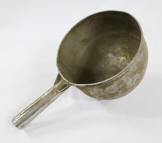 Wodonga & District Historical Society Inc
Functional object - Sand Scoop, North East Region Water Authority, Wodonga
The large aluminium sand scoop was used by Wodonga Waterworks Trust and it is part of the North East Region Water Authority collection in the Wodonga Historical Society. Wodonga's drinking water and wastewater were originally managed by the Wodonga Waterworks Trust, which was established in 1897, after Wodonga became a separate shire in 1876. In 1923 a Wodonga Waterworks Trust referendum to provide funding for new infrastructure to supply more water of better quality to Wodonga was passed. This included building the Wodonga Water Tower and it was completed in 1924. It supplied water to Wodonga until 1959, when it was drained and decommissioned after the No 1 Basin on Huon Hill was completed in 1958. In 1983 the Wodonga Waterworks Trust and the Wodonga Sewerage Authority became part of the Wodonga Council, and by 1989 a filtration plant at Huon Hill was completed, which provided filtered water of improved quality to Wodonga, in accordance with the World Health Organisation’s guidelines. In 1994 the Kiewa Murray Region Water Authority took over the Wodonga Council’s water and wastewater operations, and then in 1999 the Kiewa Murray Region Water Authority combined with the Ovens Region Water Authority and became the North East Region Water Authority or NERWA. NERWA then became known as North East Water. The sand scoop has local significance as part of the North East Region Water Authority collection donated to the Wodonga Historical Society. It also has wider state significance as a rare example of the equipment used in water management in Wodonga.Large aluminium scoop with a handle soldered on one side edge. Two holes and one indent in the end of the handle.north east region water authority, nerwa, wodonga waterworks trust, north east water, n.e. water, kiewa murray region water authority, sand scoop, metal scoop -
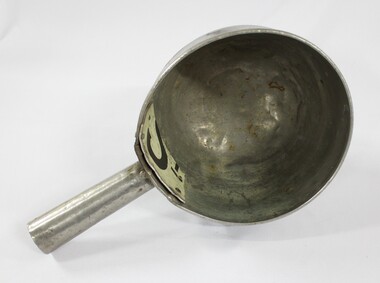 Wodonga & District Historical Society Inc
Functional object - Sand Scoop, North East Region Water Authority, Wodonga
The large aluminium sand scoop was used by Wodonga Waterworks Trust and it is part of the North East Region Water Authority collection in the Wodonga Historical Society. Wodonga's drinking water and wastewater operations were originally managed by the Wodonga Waterworks Trust, which was established in 1897, after Wodonga became a separate shire in 1876. In 1923 a Wodonga Waterworks Trust referendum to provide funding for new infrastructure to supply more water of better quality to Wodonga was passed. This included building the Wodonga Water Tower and it was completed in 1924. It supplied water to Wodonga until 1959, when it was drained and decommissioned after the No 1 Basin on Huon Hill was completed in 1958. In 1983 the Wodonga Waterworks Trust and the Wodonga Sewerage Authority became part of the Wodonga Council. And by 1989 a filtration plant at Huon Hill was completed, which provided filtered water of improved quality to Wodonga, in accordance with the World Health Organisation’s guidelines. In 1994 the Kiewa Murray Region Water Authority took over the Wodonga Council’s water and wastewater operations, and then in 1999 the Kiewa Murray Region Water Authority combined with the Ovens Region Water Authority and became the North East Region Water Authority or NERWA. NERWA then became known as North East Water. The sand scoop has local significance as part of the North East Region Water Authority collection donated to the Wodonga Historical Society. It also has wider state significance as a rare example of the equipment used in water management in Wodonga.Large aluminium scoop with a handle soldered on one side edge and a repair riveted to the interior surface of the scoop where the handle is located. The repair is a piece of sheet metal, with what looks like the lower part of the letter 'S' on it.Lower part of the letter "S" on the repair riveted to the interior surface of the scoop.north east region water authority, nerwa, wodonga waterworks trust, north east water, n.e. water, kiewa murray region water authority, metal scoop, sand scoop -
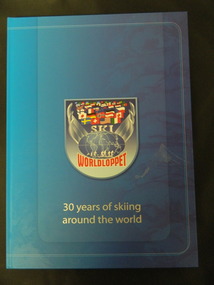 Kiewa Valley Historical Society
Book - Cross Country Skiing x2, Worldloppet - 30 Years of Skiing Around the World, 2007
The Worldloppet is a skiing race held throughout the world for cross country skiers. American Tony Wise conceived the idea of bringing together long distance skiers together. 14 ski marathons held in 4 continents (Europe, North America, Australia and Asia) with over 90,000 skiers each year.Falls Creek is on the Bogong High Plains at the top of the Kiewa Valley. Falls Creek held the first Kangaroo Hoppet in 1979 over a distance of 21 km with 80 participants. In 1995 a record 1588 participants took part. They received membership of the Worldloppet in 1991 holding the event on the last Saturday of August and haven't had to cancel the event. Two copies of a blue hard covered book with 167 pages consisting of an index (Kangaroo Hoppet page 54), information on 30 years of (cross country) skiing around the world with colored photos. cross country skiing; worldloppet; falls creek -
 Eltham District Historical Society Inc
Slide - Photograph, Bridge Street, Eltham, c.June 1990
Intersection of Main Road and Bridge Streets, Eltham. Before reconstruction of Main Road, this intersection had deep cutting embankments on all four corners. Roadworks and private development have levelled the land on the low side of the road. The Eltham War Memorial was originally located on the north western corner. in 1919. 35mm colour positive transparency (1 of 36) Mount - Agfa CS System grey 8 dotsroads, bridge street, eltham -
 Lara RSL Sub Branch
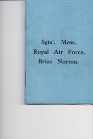
Booklet, Sgts' Mess Royal Air Force Brize Norton, R.A.F. Station, Oxfordshire, U.K, circ 1939
Sargent's, Mess Royal Air Force, Brize Norton Royal Air Force Brize Norton or RAF Brize Norton in Oxfordshire, about 65 mi (105 km) west north-west of London, is the largest station of the Royal Air Force. It is close to the settlements of Brize Norton, Carterton and Witney.Sgt's Mess Royal Air Force Brize Norton, R.A.F. Station, Oxfordshire, U.K. - Rules of Sergeant's Mess -
 Greensborough Historical Society
Photograph - Digital Image, Willis Vale site, 2014_
Photograph of the site of the 'Willis Vale' homestead, home of the Partington family. The derelict Willis Vale house was destroyed in 1964 when a fire originating from North Plenty Gorge - Kurrak Road - was lit by two teenage boys and made its way several kilometres down to Partington's Flat Greensborough.Digital copy of colour photograph."This house is where Willis Vale homestead was on Partingtons Flat"partington family, willis vale -
 Greensborough Historical Society
Report, Examining Draughtsman's Report - Watts River Aqueduct, 20/07/1897
This Field Survey was commissioned by the Melbourne Board of Works and was used to position the Maroondah Aqueduct bridge north of Greensborough at its crossing point on the Plenty River. It incorporated the use of wrought iron water pipes and therefore is of lighter construction than other similar bridges in the district. It features a traverse of the Plenty RiverThe Maroondah Aqueduct bridge is a significant example of late 19th century engineering. A 4 page reproduction of an Office of Titles document. Copy of handwritten report includes maps.maroondah aqueduct, watts river aqueduct, bridge, greensborough, office of titles, 1897, wrought iron water pipes, plenty river, melbourne board of works -
 Orbost & District Historical Society
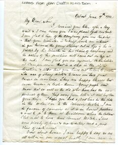
Document - letters and newspaper 'Death Notice', 1912
These letters were written and sent by John Draffin to his son. John Draffin came to Australia as a child with his parents from the north of Ireland . He came to Orbost in 1894 and was Shire Secretary from then until 1910 His children were Andrina, Eva, George, Maggie, Sally and Nellie.John Draffin was a prominent Orbost citizen involved in many community activities. This item is a useful research tool.Hand-written correspondence, on ruled paper. Central horizontal fold, some foxing on edges.draffin family, john draffin, george draffin, east gippsland shire councillor, northern ireland heritage, c.1900s -
 Orbost & District Historical Society
writing desk, before 1888
This was presented to Mr A.D. Munro by the residents of Orbost on his retirement as postmaster in 1888. In 1883 the mail terminus was at Newmerella. In July 1883 it was extended to the north side of the river and Archie Munroe became Acting Post Master. He was Post Master until 1885 when the telegraph line came to Orbost.Archie Munro was a well-known Orbost identity who first operated a boot shop in Cameron's barn. He was also active in the promotion of the first brass band in Orbost. He was the son of Hector Munro.A large brown leather portable writing desk. It has a brass handle on the top. Inside are copies of some Munro family documents in a document folder.On a brass plate-Presented to Mr A.B. Munro by the RESIDENTS OF ORBOST on his retirement as Post Master. A.D. 1888munro-archie writing-desk post-office -
 Orbost & District Historical Society
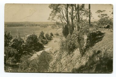
black and white postcards, Sherwood, Herbert, first half 20th century
3185.1 is a view from Hofen's Bluff at Bete Bolong. 3185.2 is a view taken from Mt Raymond looking west at swampland. 3185.3 was taken from Warrens Road, Newmerella looking over the flats towards Orbost, north-east. 3185.4 was taken at Cameron's Lagoon / Lochiel Lagoon in Orbost.These postcards are pictorial records of Orbost in the first half of the 20th century.Four black / white postcards of views around Orbost. postcards-orbost hofen's-bluff newmerella lochiel-lagoon cameron's-lagoon