Showing 4483 items
matching cities and towns
-
 Flagstaff Hill Maritime Museum and Village
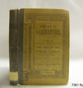
Book - Historical, Richard Osburne, The History of Warrnambool, 1887
This little book is one of only 1000 books published of the original Queen's Jubilee Edition. It spans fifty years of the history of Warrnambool from the time that the first Government Land Sales commenced. It also deliberately coincides with the 1887 celebrations of Queen Victoria's Jubilee Year of her ascension to the British Throne. The book is an invaluable reference for researchers of local Warrnambool history and has been used as a text book and reference book for local students. The book had two owners before it became part of the Warrnambool Public Library, and when the library closed down, the book was held by the Warrnambool City Council until, in 1974, it was transferred to the newly established Flagstaff Hill Maritime Museum and Village. The author, Richard Osburne, (1825-1895) was born in Australia. He moved to Warrnambool in 1847 as the first local Journalist. In 1851 he founded the Warrnambool Examiner newspaper which he operated until the end of 1880. Osburne was much involved in civic and community affairs of the town, and he set himself the task of recording the history of the city's early pioneers. In the introductory pages of the book the author refers to himself as "The Father of the Warrnambool Press". Only 1,000 copies of this edition of the book were printed. In September 1980 a facsimile edition was printed with the addition of illustrations from the period, an index and relevant annotations by local historian T.A. Wicking (Tom Wicking). This later book was named the Premier Town Edition, due to Warrnambool being awarded the title of Premier Town in Victoria in 1979-82 by the Premier of Victoria; it also received the inaugural award in 1959 and a later award in 1988-91. This book is rare. It is one of only 1000 copies printed, and one of three in the Collection of Flagstaff Hill Maritime Museum and Village. The book was dedicated to the early colonists as well as to the new arrivals by the writer, Richard Osburne, who entitles himself as "The father of the Warrnambool Press". The content of the book is invaluable as a reference for Warrnambool and District's local history in its early colonial and pioneering days. It provides the information that helps in an understanding the foundation that the city was built on, connecting the people of today to the pioneers of the past. The inscriptions of two previous owners of the book, at least one of whom was a local resident, gives additional significance to this copy. The History of Warrnambool: Capital of the Western Ports of Victoria From1847 (when the first Government Land Sales took place) up to the end of 1886, By Richard Osburne, Proprietor of the Warrnambool Examiner from 1851 to the close of 1880. Author: Richard Osburne Publisher: Prahran: The Chronicle Printing & Publishing Company Limited Date: 1887 (MDCCCLXXXVII) Edition: Original: Queen's Jubilee Edition Small book with hard cover and reinforced spine. Dust jacket front has been pasted over front hard cover. The hardcovers are covered with clear adhesive plastic covering. Inscriptions include a typed label on the spine, a stamp at base of the fly page, on the loose page inside front cover, on inside back cover, and two hand written names on the second fly page; Jackson Giblett and G. M. Potter. The first fly page has a message to the readers, as shown in the Inscriptions of this record.Label on spine "R.A. 994.57 OSB" Inscriptions on second fly page: "Jackson Giblett / 1886" and "G.M. Potter, 70 Japan Street" Printed on fly page: "PRICE, FIVE SHILLINGS" Stamp of front end paper: WARRNAMBOOL / PUBLIC LIBRARY", "000336" and in a rectangular border " - - - - - - / WARRNAMBOOL / PUBLIC LIBRARY" First fly page: "THE QUEEN'S JUBILEE EDITION. TO OLD COLONISTS AND YOUNG AUSTRALIANS, OR NEW ARRIVALS, THIS HISTORY OF THE RISE AND PROGRESS OF THE CAPITAL OF WESTERN VICTORIA, IS DEDICATED AS INTERESTING AND USEFUL, BY "THE FATHER OF THE WARRNAMBOOL PRESS" RICHARD OSBURNE." Stamp inside back cover: "WARRNAMBOOL LIBRARY/ Liebig Street / Warrnambool 3280 / (055) 6- 2258"warrnambool, shipwreck coast, flagstaff hill, maritime museum, maritime village, the history of warrnambool, richard osburne, osturne's history of warrnambool, queen's jubilee edition, 1847-1887, warrnambool history, the chronicle printing and publishing company, capital of the western ports of victoria, first government land sales, warrnambool examiner, five shillings, warrnambool's first reporter, warrnambool public library, 1887, 1979, premier town, premier edition, queen's jubliee, queen victoria's jubilee, western ports of victoria, 1847, government land sales, chronicle publishing and printing co., g m potter, 1000 copies, t a wicking, jackson giblett, 1886, japan street, old colonists, young australians, new arrivals, rise and progress, capital of western victoria, interesting and useful, the father of the warrnambool press -
 Warrnambool and District Historical Society Inc.
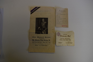
Memorabilia - Two articles of civic events in Warrnambool, Kaye & Son, Warrnambool Printers, mid 20th century
The card relates to the Official Centenary Ball held in the Warrnambool Town Hall in March 1947 to celebrate the city's Centenary in 1947. Warrnambool was founded as a port settlement to service the farming interests in the area, with the first land sales held in Melbourne in July 1847. The leaflet is a programme of the Civic Memorial Service held in the Botanic Gardens in Warrnambool in February1952 on the occasion of the death of King George VI of England. Both items came from memorabilia held by the Bamford family of 8 Monash Avenue Warrnambool and it is presumed that one or more members of that family attended the events.These items are of minor significance as mementoes of events in Warrnambool mid 20th century.1 A white card with black printing and a logo .2 A sheet of white paper folded to make four pages with black printing and a photograph of King George VI of Englandwarrnambool memorabilia -
 Kew Historical Society Inc
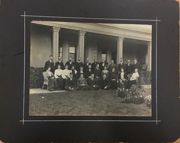
Photograph, Kew Congregational Church members at South Esk, circa 1900, c.1900
Ordsall, renamed Southesk in the 20th century was built for John Halfey in or before 1865. The house was rebuilt in the 1870s to designs by architect Michael Hennessy. In 1882 the house was redecorated by the firm of Culls Hill & Co., who hired the artists 'Mr Vandenbrandt' and 'Signor Rizzi" to paint the ceilings of the ballroom and the drawingroom. The artistic triumph was described in detail in The Argus, 30 October, 1882. In 1947, Southesk was purchased by the Kew City Council. For 23 years it was used as a meeting place for community groups. The house was then demolished in 1970 to make way for a new Town Hall.This is the earliest known photograph of Ordsall / South Esk, a significant mansion in Kew, built for John Halfey and now demolishedMembers of the Kew Congregational Church in front of one of the verandas of Southesk, circa 1900.congregational church - kew (vic), south esk - south esk - ordsall - kew (vic) -
![Section of mural from the ballroom of 'Ordsall' [Southesk], Cotham Road](/media/collectors/550653872162f11fb04854aa/items/57295b902162f108e8d6367a/item-media/614c29d34739c077d925ddc5/item-fit-380x285.jpg) Kew Historical Society Inc
Kew Historical Society IncPainting - Section of mural from the ballroom of 'Ordsall' [Southesk], Cotham Road, Cullis Hill & Co, 1882
Ordsall, renamed Southesk in the 20th century was built for John Halfey in or before 1865. The house was rebuilt in the 1870s to designs by architect Michael Hennessy. In 1882 the house was redecorated by the firm of Culls Hill & Co., who hired the artists 'Mr Vandenbrandt' and 'Signor Rizzi" to paint the ceilings of the ballroom and the drawingroom. The artistic triumph was described in detail in The Argus, 30 October, 1882. In 1947, Southesk was purchased by the Kew City Council. For 23 years it was used as a meeting place for community groups. The house was then demolished in 1970 to make way for a new Town Hall.The interiors of the two main reception rooms at Ordsall included some of the most outstanding domestic frescos painted in Australia in the late Victorian period. These frescos were executed by artists hired by the firm of Cullis Hill & Co. While a number of photographs were taken of the interiors prior to the house's demolition in 1970, this small fragment of the fresco is one of only three extant. The fresco allows conservators to examine and evaluate fresco techniques of the period.One of only two fragments of the painted domed ceiling of the ballroom of Ordsall (later renamed Southesk) which once stood at the corner of Cotham Road and Charles Street, Kew. This triangular piece of the fresco is of a cherub's face.Label: 'This is from the "Southesk" ballroom 14-7-70'ordsall, southesk, cullis hill & co. -
![Section of mural from the ballroom of 'Ordsall' [Southesk], Cotham Road](/media/collectors/550653872162f11fb04854aa/items/5729628d2162f108e8d6d03f/item-media/614c29204739c077d925d5a8/item-fit-380x285.jpg) Kew Historical Society Inc
Kew Historical Society IncPainting - Section of mural from the ballroom of 'Ordsall' [Southesk], Cotham Road, Cullis Hill & Co, 1882
Ordsall, renamed Southesk in the 20th century was built for John Halfey in or before 1865. The house was rebuilt in the 1870s to designs by architect Michael Hennessy. In 1882 the house was redecorated by the firm of Culls Hill & Co., who hired the artists 'Mr Vandenbrandt' and 'Signor Rizzi" to paint the ceilings of the ballroom and the drawingroom. The artistic triumph was described in detail in The Argus, 30 October, 1882. In 1947, Southesk was purchased by the Kew City Council. For 23 years it was used as a meeting place for community groups. The house was then demolished in 1970 to make way for a new Town Hall.The interiors of the two main reception rooms at Ordsall included some of the most outstanding domestic frescos painted in Australia in the late Victorian period. These frescos were executed by artists hired by the firm of Cullis Hill & Co. While a number of photographs were taken of the interiors prior to the house's demolition in 1970, this small fragment of the fresco is one of only three extant. The fresco allows conservators to examine and evaluate fresco techniques of the period.One of only two fragments of the painted domed ceiling of the ballroom of Ordsall (later renamed Southesk) which once stood at the corner of Cotham Road and Charles Street, Kew. This roughly square piece of the plasterwork shows a woman's head. Given the size of the face, it is believed that this section of the fresco represents one of the four 'geographic depictions of the earth including the seasons, night and morning'.Label: 'This is from the Southesk Ballroom 14-7-70'cullis hill & co., fresco, ordsall, southesk -
![Section of mural from the Drawingroom of 'Ordsall' [Southesk], Cotham Road](/media/collectors/550653872162f11fb04854aa/items/572965572162f108e8d71dfd/item-media/614c29844739c077d925d8ef/item-fit-380x285.jpg) Kew Historical Society Inc
Kew Historical Society IncPainting - Section of mural from the Drawingroom of 'Ordsall' [Southesk], Cotham Road, Cullis Hill & Co, 1882
Ordsall, renamed Southesk in the 20th century was built for John Halfey in or before 1865. The house was rebuilt in the 1870s to designs by architect Michael Hennessy. In 1882 the house was redecorated by the firm of Cullis Hill & Co., who hired the artists 'Mr Vandenbrandt' and 'Signor Rizzi" to paint the ceilings of the ballroom and the drawingroom. The artistic triumph was described in detail in The Argus, 30 October, 1882. In 1947, Southesk was purchased by the Kew City Council. For 23 years it was used as a meeting place for community groups. The house was then demolished in 1970 to make way for a new Town Hall.The interiors of the two main reception rooms at Ordsall included some of the most outstanding domestic frescos painted in Australia in the late Victorian period. These frescos were executed by artists hired by the firm of Cullis Hill & Co. While a number of photographs were taken of the interiors prior to the house's demolition in 1970, this small fragment of the fresco is one of only three extant. The fresco allows conservators to examine and evaluate fresco techniques of the period.A fragment of the painted domed ceiling of the drawingroom of Ordsall (later renamed Southesk) which once stood at the corner of Cotham Road and Charles Street, Kew. This rectangular fragment of painted plaster is a small section of the rectangular frieze of neo-gothic scenes that were a feature of the drawingroom ceiling. The fragment differs from those remaining from the ballroom in that it includes a section of gold leaf.Label: 'This is from "Southesk" drawing room'ordsall, southesk, cullis hill & co., halfey, john -
 Bayside Gallery - Bayside City Council Art & Heritage Collection
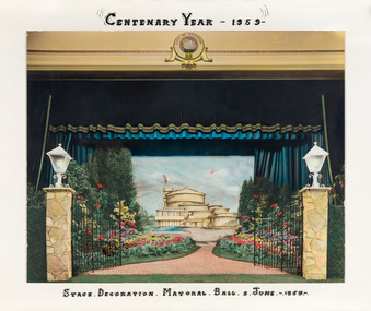
Photograph - hand-coloured photograph, Brighton Centenary Year, Stage decoration, Mayoral Ball, c. 1959
This work was presented to The Mayor and Mayoress, Cr. and Mrs R.G. Ward, by the citizens of Brighton to commemorate the Brighton Centenary in 1959. Brighton was first incorporated as a borough on 18 January 1859, it became a town on 18 March 1887 and was proclaimed a city on 12 March 1919. The new Brighton Municipal Offices were designed by Kevin Knight of Oakley and Parkes with the engineers John Connell and Associates and were erected by Prentice Builders Pty Ltd. The foundation stone was laid on 13 February 1959 and the building was opened on 21 July 1961. The interior decoration and furniture was by Grant Featherston.brighton centenary, brighton town hall, stage decoration, mayoral ball, brighton municipal offices, civic centre, oakley and parkes, kevin knight, r.g. ward, mayor -
 Glen Eira Historical Society
Letter - MARRIOTT FAMILY
This file contains three items of this family’s correspondence 1/A Carbon copy page giving details of Robert and John Marriott and John Long, from their arrival in Victoria. Includes brief history of their lives becoming councillors for the city of Caulfield. Also Robert’s early market garden business in the area, and how he established Camden Town Methodist Church. 2/A handwritten letter to Mr. Murray from Catherine Marriott dated 29th Oct (no year) 3/A Two handwritten pages of working notes in Peter Murray’s writing, author for ‘Sand, Swamp and Heath’.marriot robert, long john, gold, caulfield, councillors, st. kilda, hawthorn road, alexandra hospital, hospitals, flowers street, laura street, glen huntly road, marriot john, bambra road, field street, goe street, market gardeners, bentleigh, marriott thomas, methodist church, sunday schools, camden, hawthorn road, indoor bowling club, sporting clubs, lewis bobby, jockeys, marriott catherine, marriott arthur, hughes d, blanche mrs., stables, kooyong road, ricketson h, mallinson j, kunney m, evans john, grange road, millar w, nyora road, rate book -
 Glen Eira Historical Society
Letter - Orrong Crescent, 84, Caulfield North
Two items abut this property: 1/Copy of letter from S R Birch of National Trust Of Australia that acknowledges 84 Orrong Crescent Caulfield North built 1889 has been recorded by the National Trust. Letter sent to owner H C Chesterfield dated 30/01/1974 with cc's to the Town Clerk, City Of Caulfield and Trevor Hart. Address was formerly numbered 120. 2/Data image of one of two black and white photos for GEHS-held photo album 'Historical Caulfield to 1972' p152. Hand noted as 'Bonhurst'.chesterfield hc, north caulfield, cast iron work, birch s r, architectural styles, city of caulfield, orrong crescent, architectural features, hart trevor, houses, filbert street, verandahs, house names, 'bonhurst', 'historical caulfield to 1972' -
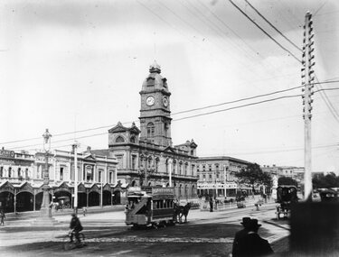 Ballarat Tramway Museum
Photograph - Black & White Photograph/s, Horse Tram Sturt St, c1890
Photograph of a horse tram (possibly No. 7), with a Havelock Tobacco advertisement, travelling westbound in Sturt St. on the north side with the City of Ballaarat Town Hall (clock showing 905). Traffic in Sturt St was two-way on either side of the median strip which at the time did not extend fully between Lydiard St and Armstrong St. The photograph includes the gas street lamp in the middle of the Sturt and Lydiard Streets intersection and a telephone/telegraph pole on the right side. Several horse-drawn cabs in the photograph, along with some men. In the background are shops for Cameo Cigarettes, Tea Merchants, C Ekans? Chemist, J T Marsh Hatter, the Town Hall and Snows department store promoting a clearing sale. The photo has been taken from the Post Office Steps, c1890. State Library Multimedia Source Catalogue does not give the name of the photographer and the date of the photo. Acknowledgement of the source of the photograph is required.Yields information about Sturt St and horse trams c1890 and the use of the street in the early morning.Black and white print from the State Library of Victoria.On rear in pencil in bottom left hand corner "Copy of H92 320/106" and in centre along bottom edge "Reproduction Rights Reserved - Copied by State Library of Victoria".trams, tramways, sturt st, lydiard st. north, horse trams, ballarat town hall, two way traffic, tram 7 -
 Federation University Historical Collection
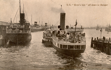
Postcard, S.S. "Erin's Isle" off down to Bangor, 1912
Erin's Isle was a paddle steamer built in 1912 by Messrs. A. & J. Inglis Pointhouse, Glasgow, for the Belfast and County Down Railway Company. It provided a regular service between Belfast Lough and Bangor, County Down in the summer season. In November 1915 it was requisitioned by the Admiralty, initially for transport purposes, and later as an auxiliary mine sweeper. Surviving World War One, this vessel as lost on 7 February 1919 after hitting a stray mine at the entrance of the Thames Estuary and immediately sank. There were 23 lives lost, and 28 survivors. Bangor is a city in Gwynedd Unitary Authority, north west Wales, and one of the smallest cities in Britain. This postcard was sent home to Australia by a six bob a day tourist, and member of the Australian AIF on active service. During leave soldiers often visited tourists sites, family, or towns important to their ancestral heritage.A view of paddle steamer with three moored mail steamers are visible to the left, and a pier and lamp on right. A ship can be seen iin distance on right. S.S Erin's Isle off down to Bangorchatham-holmes family collection, bangor, belfast, mail ships, steam ship, six bob a day tourist -
 Kew Historical Society Inc
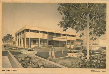
Drawing, AK Lines, Macfarlane & Marshall, Kew Civic Centre, c.1970
The Kew Civic Centre (A K Lines, MacFarlane & Marshall, 1972) was built next to the Kew Civic Hall (A C Leith & Bartlett, 1960) on the site of the former mansion Ordsall (later renamed South Esk). Whereas the entrance to the Civic Hall was positioned off Civic Drive, the main entrance to the Civic Centre faced Cotham Road, as shown in the undated perspective drawing of the proposed building. The Civic Hall was used for public functions and performances, while the Civic Centre was used for civic offices. It also contained the Council Chamber. The building opened in 1972, following the relocation of the councillors and council officers from the former Town Hall in Walpole Street (now a Woolworth's supermarket). Following the amalgamation of the former City of Kew into the City of Boroondara in 1994, the Civic Centre was sold to Trinity Grammar School. The exterior of the Centre has been modified by Trinity Grammar.A report for Heritage Victoria (date) describes how two architectural firms dominated the designs for new civic buildings in Victoria during the post war period. The report claims that: "An interesting sub-theme in the erection of post-war municipal offices in Victoria is that a considerable proportion were designed by the same three or four Melbourne-based architectural firms, who established themselves as the leading specialists in this type of work. The two most prolific firms in this regard were A K Lines, MacFarlane & Marshall, and A C Leith & Bartlett; both, in fact, had made names for themselves as designers of local government offices prior to the Second World War. Lines' office, for example had designed the Eltham Shire Offices in 1941, while Leith's firm had been responsible for the celebrated Heidelberg Town Hall in 1937). Both practices parleyed this early experience into a lucrative post-war career, designing numerous municipals offices well into the 1970s." (Survey of Post-War Built Heritage in Victoria, Built Heritage Pty Ltd, 2010.) The perspective drawing importantly captures the original design and function of the exterior of the building and its public entrance.Hand-coloured perspective sketch of the new Kew Civic Centre, completed in 1972 to designs by A K Lines, MacFarlane & Marshall; and located on the corner of Charles Street and Cotham Road, Kew. The sketch represents the front elevation of the building and its relation to the preexisting Kew Civic Hall at right. The three storey building features strong vertical concrete buttresses that extend across the three levels. KEW CIVIC CENTRE / A K LINES, MACFARLANE & MARSHALLkew civic centre, a.k. lines, macfarlane & marshall, architectural drawings, civic buildings -- kew (vic.), town hall -- kew (vic) -
 Mission to Seafarers Victoria
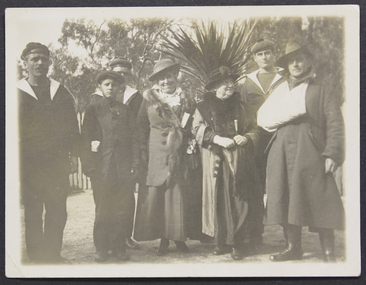
Photograph, French sailors at zoo - Madame Lion & Miss Godfrey, 1917
Marie Lion migrated with her sister, Berthe Mouchette and her husband in 1885. Berthe established an art school in the city. After the death of her husband the sisters purchased a school, Oberwyl, in St Kilda in 1885. The school was later one of the LHLG schools. Berthe was the founder of the Alliance Française of Melbourne in 1890. With the Great Depression, the sisters had to sell Oberwyl and moved to Adelaide. They returned to France during WWI to nurse wounded soldiers. And returned to Adelaide in 1916 after Marie contracted an infection. She was the South Australia representative of the "Société d’assistance maternelle et infantile". After the end of the war a number of French villages were ‘adopted’ by cities in Australia. Dernancourt, a small village in the Somme was adopted by Adelaide, and Mme Mouchette and Mme Lion worked to raise funds to help in the rebuilding of the almost completely destroyed town.The picture shows the link with the French community. Ethel and her sister Frederica Godfrey could speak French and were well acquainted with the members of this community: Charlotte Crivelli for example. Frederica was secretary of the Alliance Française of Melbourne in the early 1900, in 1917 she also became Honorary Secretary of the French Red Cross, funded by Charlotte Crivelli.Portait of two ladies standing in the middle with 3 soldiers from the French Navy, a wounded digger and a young man.French sailors at zoo / Madame Leon (Lion is the correct spelling) & Miss Godfreylion, marie (1855–1922), mouchette, berthe (1846–1928) nee lion, alliance française of melbourne, société d’assistance maternelle et infantile, france, french, zoo, french red cross, crivelli, charlotte (1863–1956), anzac, french navy, oberwyl, ethel augusta godfrey 1861-1935, frederica godfrey -
 Glen Eira Historical Society
Album - Album page, Neerim Road, Circa 1972
This photograph is part of the Caulfield Historical Album 1972. This album was created in approximately 1972 as part of a project by the Caulfield Historical Society to assist in identifying buildings worthy of preservation. The album is related to a Survey the Caulfield Historical Society developed in collaboration with the National Trust of Australia (Victoria) and Caulfield City Council to identify historic buildings within the City of Caulfield that warranted the protection of a National Trust Classification. Principal photographer thought to be Trevor Hart, member of Caulfield Historical Society. Most photographs were taken between 1966-1972 with a small number of photographs being older and from unknown sources. All photographs are black and white except where stated, with 386 photographs over 198 pages. "Edenkillie" was the home of Frederick Jowett, Caulfield's shire secretary and town clerk from 1887 to 1921. The Outer Circle Railway's Oakleigh section opened 1890 and closed 1895. Victorian Heritage database (as of 26/10/2021) HO45 Edenkillie https://vhd.heritagecouncil.vic.gov.au/places/35545 "Edenkillie" at 37 Neerim Road, Glenhuntly, is a substantial two storeyed polychrome brick villa, built for Frederick Jowett, municipal secretary, in 1890. It has aesthetic, historical and social significance. "Edenkillie's" aesthetic value derives from its survival as a substantially intact example of a common villa form expressed in polychrome brickwork. Its historical significance lies in its association with Frederick Jowett, Shire of Caulfield secretary and town clerk for over three decades. Its social significance is derived from the building's ability to demonstrate the kind of lifestyle which a local government administrator could enjoy during the Land Boom.Page 145 of Photograph Album with four landscape photographs from Neerim Road: two photographs of No 37 and two of the Outer Circle Railway Reserve.Handwritten: Neerim Road [top left] / 37 NEERIM ROAD 1OCT 1972 [under top left photo] / 37 NEERIM RD 1 OCT 1972 [under top right photo] / OUTER CIRCLE RAILWAY RESERVE MURRUMBEENA [under bottom left photo] / 145 [bottom left]trevor hart, neerim road, murrumbeena, caulfield, edenkillie, glen huntly, polychrome brick, mansions, frederick jowett, town clerks, shire of caulfield, outer circle railway, railways, parks and reserves, outer circle railway reserve, cast iron work, verandahs, balconies -
 Ballarat Heritage Services
Photograph - Photograph - Colour, Sunnyside Mill Bridge over the Yarrowee, Hill Street, Ballarat, 2016, 17/09/2016
"A joint meeting of city and town ratepayers, convened by Messrs Francis Jago and Henry Johns, interested in the formation of a cart bridge in Hill street, over the Yarrowee Creek, was held on Saturday evening, in the Societies Hall, corner of Skipton and South streets, with the view of taking united action in the matter. Mr Morris was voted to the chair, : and about 60 persons were present. The chairman stated that the object of the meeting was that united influence should be brought to bear upon the City and Town Councils, so that a cartbridge should be erected. He said that Mount Pleasant would no doubt be thickly populated in a few years, and the bridge would prove a great boon to the inhabitants of the locality. By means of a cart bridge drays, would be enabled to save on their journeys to and fro between the mount and the batteries, at least a mile and a half each time. He hoped that the councillors for the south ward would assist them in this matter. Mr Jago, as one of the conveners of the meeting, said that united action on the part of both eastern and western ratepayers was requisite, so as to exert a strong pressure upon the City and Town Councils, in order that the work should be carried but. Mr Grainger moved the first resolution as follows;—“ That the construction of a cart bridge over the Yarrowee Creek at Sunnyside, to facilitate communication between the residents of the city and town, is urgently necessary, and that in the interests of both municipalities the two councils be asked to at once jointly carry out the work. In doing so he said that the necessity of a cart-bridge for the residents of Mount Pleasant would be apparent when the number of batteries, tanneries, and also the Woollen Mill, in the district were considered. The place was of growing import ance, and ready communication should at once be established. Another reason was that an immense saving in time would be effected. It was quite a common occurrence to see one, two, or three drays stuck in the bed of the creek which had gone that way to make a short cut. Now, what with the horses floundering about and breaking their harness, it seemed a wonder to him that life had not been destroyed before now, just through the want of a cartbridge. Mr Johns seconded the resolution. Mr Robert Calvert supported the resolution, and said that it was disgraceful action on the part of the representatives of the south ward that the work had not been executed long ago. They should come together like men and demand that the work should be done, and if not done they should not pay rates until it was. (A voice—“But they’ll make us.” Laughter.) The wooden footbridge across the creek was “only a wooden fabric, not fit for a Christian to walk across, and steps should be taken to remedy this also. Mr Blight, a resident of Mount Pleasant, said that, in common with others, he had been opposed to the erection of the bridge two years ago, but his views had since been altered. Cr. Morrison, who was present, said that the fault of the cartbridge not being erected over the Yarrowee at Hill street lay not with the City Council, but with their neighbors, who had always been opposed to its erection there. In 1874 a motion was carried at a meeting of ‘the City Council" by which the sum of £5OO had been voted to carry but the work. As the bridges over the Yarrowee were joint undertakings of the city and town, they had, by the provisions of an act of Parliament, called upon the Town Council to assist them in the erection of the bridge. In consequence, a conference of the two corporate bodies had taken place, when a motion was moved by Cr Howard, the representative of the south ward, and seconded by Cr Turpie, of Ballarat East—“ That the bridge should be erected at Hill street.” The motion was rejected, principally through the eastern representatives, who wanted the bridge lower down. Since then the two councils had often met to consider, the question of bridges over the Yarrowee Creek, but nothing had been done at the meetings, as the Eastern Council wanted the bridge in one place and the City Council in another. He had himself, when first elected to the council, given notice of motion affirming the desirability of a bridge, at the place now fixed upon. The Woollen Company was growing in importance, and a direct, road to its works would greatly advance its interests. For the working, expenses of each ward £400 was annually, appropriated; and this amount would not be sufficient carry out the work. They would have to obtain a special grant of about £900, as Hill street would require a culvert to be erected therein, as now it was virtually an open drain which carried the drainage of the western plateau to the Yarrowee. He advised that strong pressure should be exerted, specially upon the Eastern Council, and then the work might be carried out. He thought that if the foot bridge was repaired, and large stones thrown into the creek, it would do until the bridge could be erected. The chairman then put the resolution, and it was unanimously carried. Mr Hamilton moved the second resolution— “That Messrs Fern, Greenwood, Peirce, and Jago be deputed by the meeting to wait upon the City and Town Councils and present the first resolution; also that petitions in its favor be signed by all ratepayers interested.” Mr Haigh seconded the resolution, which was carried. Votes of thanks to Cr Morrison for his attendance, and to the chairman for presiding, were passed, and the proceedings terminated." (Ballarat Star, 9 August 1881, page 3) "WOOLLEN MILL BRIDGE YARROWEE IMPROVEMENTS Though brief the official ceremony of opening the bridge across the Yarrowee Creek, near the Sunnyside Woollen Mills, was of an interesting character. It took place at noon yesterday in the presence of the Mayors and councillors of the City and Town. Hon. F. Hagel thorn (Minister of Agriculture).Hon Brawn. M.L.C., Lt-Col Morton (Acting City Clerk). Mr J. Gent (Town Clerk of Ballarat East), Mr A. Farrer (City Engineer), Lt. L. Finch (who is about to leave for the Front, and who assisted Messrs A. Farrer and G. Maughan in carrying out the project, Mr W. Hurdsfield (Clerk of Works) and others. An apology was received from Mr J. McClelland, contractor for the work. Mayor Hill expressed pleasure in Introducing Mr Hagelthorn, who had at great personal sacrifice and inconvenience come from Melbourne to perform the opening ceremony of that beautiful bridge, which was of great improvements that had been effected.When Mr Hagelthorn was Minister of Pubic works he visited Ballarat specially to see the condition of the creek, which at that time was in a disgusting state from a sanitary standpoint. After viewing the position, and realising the justice of the claim. Mr Hagelthorn made strong representations to the Government of which the was a member with the result that it voted £17,000 for the work. That action had been the means of turning a plague spot into a thing of beauty. They therefore owed a deep debt of gratitude to Mr Hagelthorn and the Government of which he was a member, and they were particular grateful to Mr Hagelthorn for coming to Ballarat to perform the open ceremony. Mayor Levy said he could bear testimony to the good work Mr Hagelthorn had always done for Ballarat. In him Ballarat and district always had a good friend. He thought Mr Hagelthorn would feel amply gratified at seeing the good work that had been done. It would serve as some reward for the expenditure, on behalf of the residents of Bal larat, of the amount of money made available through Mr Hagelthorn's instrumentality for the two municipalities. Otherwise the City and Town councils would not have been able to carry out so necessary and so beneficial a work. There was a great amount of work yet to be done, and when the financial market became low stringent Mr Hagelthorn would no doubt be pleased to take the necessary steps to have money provided for further works which could not be undertaken at the present time. The adjacent woollen mill was a standing monument to what was being done in Ballarat, and what ever the City and Town Councils or the Government could do to encourage such manufacturing enterprise should be done, and he was glad to be able to say that was being done as far as finances would permit. He concluded by presenting Mr Hagelthorn with a gold mounted pocket-knife with which to cut the ribbon stretched across the centre of the structure as a bar to traffic. The Hon. F. Hagelthorn, who was greeted with applause said before him was a good work well done in the interests of the public. Real prosperity could only be achieved by a movement carried out by the people to increase natural productiveness. Most of them had been made aware, on account of the war par tiularly, that the people who were best equipped, the industries that were best organised, and the Governments that were most intelligently controlled would get the most of this world's goods and some of its luxuries that Would be denied other people less efficient. Any thing the Government could do to promote industry and to increase the reward of those engaged in it, both employer and employee, would be done. Most Governments would do but little in that regard. ... " (Ballarat Courier, 13 September 1916, page 4)Bluestone and iron bridge over the Yarrowee River at Hill Street, Ballarat.sunnyside mill, sunnyside woollen mill, ballarat woollen mill, bridge, yarrowee creek, francis jago, mount pleasant, yarrowee river, robert calvert -
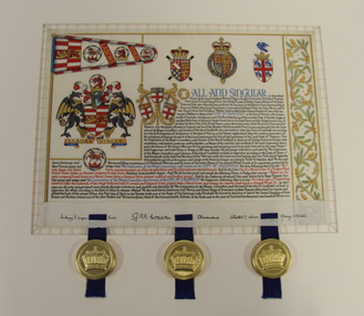 Glen Eira City Council History and Heritage Collection
Letters Patent, Letters Patent for the Grant of Arms to the City of Caulfield presented on 1st May, 1977, 01/05/1977
Glen Eira has a long history of association with various heraldic forms. From its early years the municipality of Caulfield had used the armorial bearings of the Caulfield Family (the Charlemonts of Castle Caulfield) to represent the roads board and later the town and city. In 1969 Caulfield City Council began planning to apply for an official coat of arms for the City. In 1974 Horace Hall, a Balwyn North resident and member of the Heraldry Society in London advised Council that the current usage was illegal, and that the Houston family, current owners of the Caulfield Arms could take legal action against Council for 'usurping their arms'. Mr Hall was commissioned to develop new heraldry for the City, and in conjunction with J. P. Brooke Little at the College of Arms, London, he prepared an acceptable design for Caulfield's Coat of Arms. The Council paid an additional sum to have a standard painted on the Letters Patent and the municipality's new coat of arms was drawn up in June 1975. The Coat of Arms retains a number of heraldic elements from the original Caulfield family insignia, including the dragons, the colours and the elements of the shield. The newly registered coat of arms and Letters Patent document for the granting of arms was presented at a civic service to mark the granting of armorial ensigns and the city banner to the City of Caulfield on the 1st May 1977. Significant elements of the coat of arms granted by these Letters Patent are as follows: The motto 'Labore Vinces' translates to 'By our labours we will conquer'. The helmet represents the rank of the owner. Public authorities are granted an esquire's helmet. The brickwork on the crest is a recognised emblem of local government. The Letters Patent also display a banner and a badge, both official symbols of the City of Caulfield. The badge, which is displayed on the banner as well as on its own, features a bridled horse. This represents the importance of racing, the Caulfield racecourse and the Caulfield cup to the municipality. These letters patent officially proclaim the granting of the coat of arms to the City of Caulfield. They are highly significant to the City of Glen Eira as they are the primary document that signifies the official and ceremonial heraldic powers of the Coat of Arms of the City of Caulfield. Mounted Letters Patent illuminated document for the Grant of Arms to the City of Caulfield presented on 1st May, 1977. Hand written and hand painted on cream coloured parchment using different coloured inks, mainly black, blue, red and gouache and gold paint. The bottom edge is folded up over itself approx. 45mm revealing the flesh side of the parchment, which displays black ink signatures and three sets of two horizontal slits that hold three blue ribbon. The ribbons support three wax seals in round, gold coloured metal cases held by the wax through slots in the casing. Although covered by the cap top, each wax seal within displays a different flag emblem with a crown on top, surrounded by a ring of text (difficult to read), noted when the cases were opened during conservation treatment. See attached transcription.arms, symbol, heraldry, glen eira, council, caulfield -
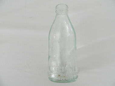 Kiewa Valley Historical Society
Bottle Milk, mid to late 1900's
This glass milk bottle was manufactured and used mid to late 1900's (1834 Victorian dairy industry was founded), until the time that cheaper containers were invented(plastic bottles and polyethylene plastic lined cardboard cartons). In 1909 the supply of pure bottled milk was required for babies to overcome infant mortality due to unhygienic milk sources (unclean containers and unpasteurized milk). Due to the volume of milk being processed and hand milking could not keep up with demand, dairy farms introduced milking machines in the late 1930's. The great increases in dairy herds from the average of 18 cows per heard in 1950's to 142 cows per herd in 1996 required milk tankers to pick up the regions milk supply. This bottle was so constructed to be easily moved within the milk processing plants from the delivery vats/holding tanks to the final corking/sealing of the bottles for eventual distribution. From 1958 the milk bottle slowly became phased out of production. At this point in time Melbourne was drawing 160,000 bottles per week from the two major glass bottle works companies, e.g. Melbourne Glass Bottle Works Co.Victoria was the major state supplier of cows milk in the history of Australian milk production from the early 1800's. The Kiewa Valley and its region was a major contributor to meet that demand. Each bottle was "branded" during manufacturing to show the contents (pasteurized milk) and where it originated from (region and supplier). This method of recycling the bottles back to specific dairy farms was a good control method but an uneconomical "on cost" which was replaced by the "throw away" less costly plastic and cardboard containers. Kiewa Valley dairy herds had marked bottles bearing "90/9", "6/18", "6/33", "6/35" and "6/36" Found under the house at 1 Beauty Ave., Mt BeautyThis heavy gauged glass milk bottle has a rim and a distinctive head at the top. This head has been manufactured to facilitate the movement of the bottled along the milk production line. The method of pouring milk into the bottle has been part of the "production line". This bottle has a one pint capacity and is made from "light green" coloured glass(a protection against light penetration). There are other milk bottles that do not have a "green" tint in them. This thick glass bottle, to contain milk, required its thickness because of the extensive handling (man and machine) before final consumption. Milk was delivered by the "milk man" direct to the homes of consumers. During this period delivery to homes in cities and towns was made initially by horse and cart and later by truck.On the bottom end of this bottle is a circle within it "6/35" and next to this "MILK" and opposite "ONE PINT". Below this "THIS BOTTLE BELONGS TO MILK BOTTLE RECOVERY LTD" and below this "AND CANNOT BE USED WITHOUT WRITTEN PERMISSION" on the base "M" underneath this "20"milk, dairy, glass bottle -
 Kew Historical Society Inc
Plan, Melbourne & Metropolitan Board of Works : Borough of Kew : Detail Plan No.1561, 1905
The Melbourne and Metropolitan Board of Works (MMBW) plans were produced from the 1890s to the 1950s. They were crucial to the design and development of Melbourne's sewerage and drainage system. The plans, at a scale of 40 feet to 1 inch (1:480), provide a detailed historical record of Melbourne streetscapes and environmental features. Each plan covers one or two street blocks (roughly six streets), showing details of buildings, including garden layouts and ownership boundaries, and features such as laneways, drains, bridges, parks, municipal boundaries and other prominent landmarks as they existed at the time each plan was produced. (Source: State Library of Victoria). This plan forms part of a large group of MMBW plans and maps that was donated to the Society by Mr Poulter, City Engineer of the City of Kew in 1989. Within this collection, thirty-five hand-coloured plans, backed with linen, are of statewide significance as they include annotations that provide details of construction materials used in buildings in the first decade of the 20th century as well as additional information about land ownership and usage. The copies in the Public Record Office Victoria and the State Library of Victoria are monochrome versions which do not denote building materials so that the maps in this collection are invaluable and unique tools for researchers and heritage consultants. A number of the plans are not held in the collection of the State Library of Victoria so they have the additional attribute of rarity.Original survey plan, issued by the MMBW to a contractor with responsibility for constructing sewers in the area identified on the plan within the Borough of Kew. The plan was at some stage hand-coloured, possibly by the contractor, but more likely by officers working in the Engineering Department of the Borough and later Town, then City of Kew. The hand-coloured sections of buildings on the plan were used to denote masonry or brick constructions (pink), weatherboard constructions (yellow), and public buildings (grey). MMBW Detail Plan 1561 outlines those residences in the area bordered by Burke Road, Loxton Street, Mount Street and Barkers Road that had been constructed by 1905 when the land was surveyed. At this time, the area nearest Burke Road had been subdivided and developed whereas the lands to the west were as yet undeveloped. The houses represented are not named on the Plan.melbourne and metropolitan board of works, detail plans, mmbw 1561, cartography -
 Kew Historical Society Inc
Plan, Melbourne & Metropolitan Board of Works : Borough of Kew : Detail Plan No.1592, 1905
The Melbourne and Metropolitan Board of Works (MMBW) plans were produced from the 1890s to the 1950s. They were crucial to the design and development of Melbourne's sewerage and drainage system. The plans, at a scale of 40 feet to 1 inch (1:480), provide a detailed historical record of Melbourne streetscapes and environmental features. Each plan covers one or two street blocks (roughly six streets), showing details of buildings, including garden layouts and ownership boundaries, and features such as laneways, drains, bridges, parks, municipal boundaries and other prominent landmarks as they existed at the time each plan was produced. (Source: State Library of Victoria). This plan forms part of a large group of MMBW plans and maps that was donated to the Society by the Mr Poulter, City Engineer of the City of Kew in 1989. Within this collection, thirty-five hand-coloured plans, backed with linen, are of statewide significance as they include annotations that provide details of construction materials used in buildings in the first decade of the 20th century as well as additional information about land ownership and usage. The copies in the Public Record Office Victoria and the State Library of Victoria are monochrome versions which do not denote building materials so that the maps in this collection are invaluable and unique tools for researchers and heritage consultants. A number of the plans are not held in the collection of the State Library of Victoria so they have the additional attribute of rarity.Original survey plan, issued by the MMBW to a contractor with responsibility for constructing sewers in the area identified on the plan within the Borough of Kew. The plan was at some stage hand-coloured, possibly by the contractor, but more likely by officers working in the Engineering Department of the Borough and later Town, then City of Kew. The hand-coloured sections of buildings on the plan were used to denote masonry or brick constructions (pink), weatherboard constructions (yellow), and public buildings (grey). In MMBW Plan No.1592, the pink line indicates that area of the plan for which the contracting engineer was responsible. Included in the Plan are a number of primarily brick villas in a section of Belmont Avenue off Cotham Road. The house ‘Uvadale’ north of Belmont Avenue, and facing Cotham Road is also included in the contract. Excluded from the contract but shown on the Plan are ‘Glendonald’, ‘Mont Belmont’ and ‘Gilden’.melbourne and metropolitan board of works, detail plans, survey plans - borough of kew, mmbw 1592, cartography -
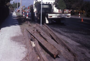 Ballarat Tramway Museum
Slide - 35mm slide/s - set of 11, May 1979c
Set of eleven colour slides (Kodak) showing the removal of tram track in Geelong, c May 1979. All in Pakington St., Newtown, ex Newtown route. 2268.1 - slide 29 - look south from the north of Retreat Road. .2 - 30 - No. 276 in background, looking south .3 - 31 - City of Newtown Town Hall in background. .4 - 32 - opposite to that of No. 29. .5 - 33 - Looking south .6 - 34 - looking south with Aphrasia St. in the background. .7 - 35 - as for .2 .8 - 36 - Opposite No. 278, looking south .9 - 1 - opposite No. 276/278. .10 - 2 - ditto .11 - 3 - Outside No. 278, looking south. Bus stop still in position. See Letter to Dave O'Neil and responses.tramways, trams, geelong, track removal, pakington st, newtown -
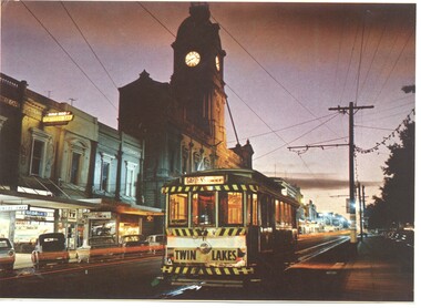 Ballarat Tramway Museum
Photograph - Illustration/s, Ballarat 11 with Town Hall
Illustration that yields information about a Ballarat tram and streetscape mid 1960's - evening photograph and a Ballarat tourist attraction at the time - the shell house.Illustrator with a printed photograph of Ballarat tram No. 11 at dusk in Sturt St, just west of Lydiard St. with Town Hall in background. Tram has destination of "GARDENS via Drummond Nth", with a "TWIN LAKES" sign on rear driver's apron of tram. On pole in front of tram is tram stop sign and a section sign. Pole painted with tram stop sign as well. On rear , printed in dark green ink is the card details etc. "Ballarat, Victoria, Looking to the City Hall, Sturt Street at sunset." See also Reg Item 669 - Nucolorvue car, BT 65 for the same photographs. On rear is a photo of the crown at the Shell house - see also Reg Item 2143 and 3079 for the same photograph. Possibly cut from a Nu-colour-vue publication.trams, tramways, sturt st, town hall -
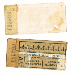 Melbourne Tram Museum
Ephemera - Ticket/s, Set of three MMTB transfer tickets, 1940's?
Set of three MMTB transfer tickets. .1 - printed in red on off white paper, with black number (A153864) for transfer to the Burwood Route, Malvern Town Hall, Esplanade or the City. Has been punched for the Burwood route. Has the conditions on the front of the ticket. .2 - printed in blue on off white paper, with black number - A EHF, 064305, for Elizabeth St and Flinders St with fares along the bottom edge ranging from 1d to 9d. Has the conditions on the rear. Has been punched for Elizabeth St and 8d. .3 - printed in green on off white paper, with black number D MCG, 948461 - has 14 different destinations on the ticket, has been punched for Gardens? Has the conditions on the rear. Could be related to the cable tram era.trams, tramways, mmtb, tickets, transfer tickets -
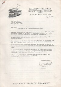 Ballarat Tramway Museum
Document - Letter/s, Ballarat Tramway Preservation Society (BTPS), "Restoration of A Double-deck Horse Tram", 1985
Copy of a letter and associated documents written to the Town Clerk, City of Ballaarat, dated Aug 1, 1985 seeking the support of the Council in attaining the body of the tramcar in Ballarat East. (Tram was actually obtained in December). Signed by the Secretary, Richard Gilbert. Mentions Frank Hanrahan as President for further information. Enclosed within letter is a two page note on BTPS Letter head outlining the history of the tramcar, its restoration, current condition, possible operation and value of the restoration. Attached as well is a folded drawing out an Adelaide double deck horse tram (Reference Reg. Item No. 706.1 ) and a photocopy of the builders of the first horse tram at the depot in 1887 (Reference Reg. Item No. 765 ). See Reg item No. 821 re date of acquiring the tramcar.trams, tramways, horse trams, collection, horse tram no. 1, city of ballaarat -
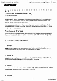 Melbourne Tram Museum
Ephemera - Timetable, Public Transport Victoria (PTV), "Disruption to trams in the City", 17/09/2021 12:00:00 AM
Set of four documents associated with a planned major Demonstration over COVID-19 lockdowns planned to be held in the city on Saturday 18/9/2021. The actual event took place outside Richmond Town Hall and then in Barkers Road Hawthorn. News stories of the night did show some trams were caught up in the event. .1 - set of 5 pages printed from the Yarra Trams website showing changes route by route and a map. .2 - set of 6 sheets from the PTV website including Metro Trains and regional services. Note many VLine crews were impacted by a COVID outbreak and were isolating. .3 - Yarra Trams Employee Notice Y21653 - digital image copy only .4 - Map of the event - digital image.trams, tramways, covid-19, timetables, tram services, events -
 Bendigo Historical Society Inc.
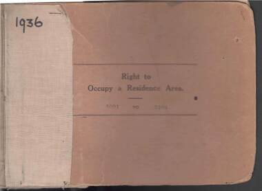
Book - RIGHT TO OCCUPY RESIDENCE AREA COLLECTION: REGISTER 1936
COLLECTION OF RIGHT TO OCCUPY A RESIDENCE AREA -LAND (RESIDENCE AREAS ) Act 1935 / thick cardboard book -cloth and string binding / written on front in texter '1936' / numbers 5001 to 5100 / inside - stubs of documents showing Granted to , of, period, Date of Right , Description of Land , Allotment, Section, City, Town , Borough , Township of , Parish of , Authorised Person . Rubber stamps show The interest of this Right has been transferred to /one stub shows Department of Lands and Survey note on Bendigo Historical Society Catalogue Sheet dated 12.6.2008 All buts completed and original application forms removed. Note -forms were originally in triplicate on one page with serrations for removal of two parts; butts remain .Residence areas in Central Goldfields.Bendigo City Council - Acquisition 1990organization, government, official -
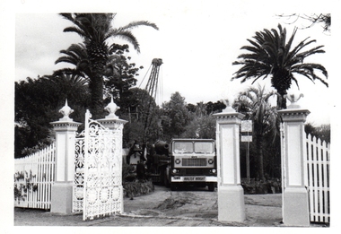 Williamstown Botanic Gardens- Hobsons Bay City Council
Photos - Cannons, 1970
The Armstrong Cannons were originally placed at Fort Gellibrand, located at the southernmost tip of the Williamstown peninsula. The Fort was developed during the 1850s as part of a defensive system for the city and port of Melbourne. The importance of the Fort batteries declined from the 1890s, when they were effectively replaced by new facilities at Queenscliff and Point Nepean, but they were still used for gunnery practice. Local residents, through the Williamstown Town Council, complained to the Acting Minister for Defence that the concussion from the guns damaged windows, walls and foundations of buildings. The Armstrong Cannons were moved from Fort Gellibrand to the Gardens in 1906. A primary source of evidence of the cannons being in the Gardens. The cannons are remembered fondly as play equipment for the local children. Many tales have been told of climbing over them and pretending to be shot out of them A collection of seven black and white photographs documenting the removal of the cannons from the Gardens Photo 1 (a) Black and white landscape image. View is looking through the main gates looking at the front of the truck, which has the name Walter Wright across the front bumper, the crane and canon. The gates and fence are painted a light colour, probably white. Photo 2 (b) Black and white landscape image. Back of loader with cannon on it. Man standing on top of the cannon bending over either tying or untying ropes. Trunk of a palm tree is on the left side of the photo with a top of a palm tree in the background. Photo 3 (c) Black and portrait white image. A cannon being loaded by the crane on to trailer. Palm tree is in the background and fronds from a palm tree can be seen in the right top corner. Photo 4 (d) Black and white landscape image. Side on view of a cannon on the truck parked outside the grounds of the Gardens. The logo of the name of the trucking company is on the door of the truck above the words ‘WALTER H WRIGHT / TRANSPORT PTY LTD / S SCHULZ ST WEST MELB’. A second cannon can be seen in the background. A bus is in the background on the middle right side of the image. Photo 5 (e) Black and white landscape image. Truck with cannon on the back leaving the ground of the Gardens. Tree on the right side of the image and power pole is behind the truck. The logo of the name of the trucking company is on the door of the truck above the words ‘WALTER H WRIGHT / TRANSPORT PTY LTD / S SCHULZ ST WEST MELB’. ‘WALTER WRIGHT’ is on the front bumper Photo 6 (f) Black and white landscape image. Cannon tied down on the back of the truck as it is being driven across the street. Three houses in the background and two cars, one is a Volkswagen Photo 7 (g) Black and white landscape image. Cannon on the back of the truck which is parked over the street from the Gardens. Three houses are in the background. Two trees bare of leaves. The front of a car in in the foreground – it has a sun visor and the steering wheel is a light colour.armstrong cannons, williamstown botanic gardens, hobsons bay city council, 1970, walter h wright / transport pty ltd -
 Bayside Gallery - Bayside City Council Art & Heritage Collection
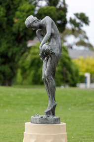
Sculpture, Charles Douglas Richardson, The Cloud, 1900 (cast 1987)
Inspired by the opening lines of Percy Bysshe Shelley’s 1820 poem of the same title, The Cloud has grace of line that epitomises the model of classically informed beauty. Richardson’s figure successfully follows the serpentine line of Art Nouveau sculpture while also echoing the influence of British New Sculpture with its focused attention to bodily detail and surface articulation. This bronze version of The Cloud was cast in 1987 from the original patinated plaster version from 1900 which is also in Bayside City Council's Collection. This work can be seen in the formal garden between the Brighton Town Hall and the Brighton Library.Art NouveauCharles Douglas Richardson, The Cloud 1900 (cast 1987), bronze, 190 x 40 x 40 cm. Bayside City Council Art and Heritage Collection. Commissioned 1987Bonze sculpture of a classical female figure looking downwards with a vessel in her hand. The sculpture sits on a rendered pedestal within a pond.sculpture, female figure, charles douglas richardson, the cloud, cd richardson, c douglas richardson, percy bysshe shelley, poem, art nouveau, new sculpture, flowers, public art, brighton -
Warrnambool and District Historical Society Inc.
Document (collection) - Henri Worland Historical Records, 1930s and 1940s
Henri Worland writings collected by the Warrnambool City CouncilPreservation of important historical recordsThe collection is in folders in a containerWritings on Warrnambool history by Henri Worland - radio talks, lectures, letters and notes, hand written and typed.henri worland, warrnambool historyhenri worland, warrnambool history -
 Warrnambool and District Historical Society Inc.
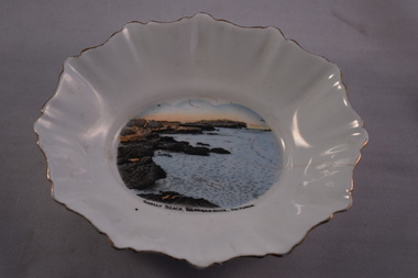
Dish, Souvenir Dish, Mid 20th century
This item is one that was sold to tourists in Warrnambool in the mid to late 20th century. The dish has been mass produced in England and the image of Shelly Beach in Warrnambool added later, probably in Australia. As it is a Royal Stafford china piece it would have been a relatively costly item. It could have been bought for use in the buyer’s home or as a present for another person. Souvenir dishes such as this one have been popular souvenir items for tourists for over 100 years. Warrnambool, as a coastal location, has always been a tourist town and it remains today an important industry for the city. This dish is of interest as an example of the items sold to tourists in the mid 20th century. It will be useful for display.This is an oval-shaped china dish with fluted sides and a fluted edge and gold paint around the edge. The gold edging is partly worn off. The dish is white with a multi-coloured image set into the base of the dish. There is a crack on one side of the dish. On the base of the dish is a crown symbol and details of the manufacturer. ‘Shelly Beach, Warrnambool, Victoria’ “Royal Stafford China Made in England” tourism in warrnambool, history of warrnambool -
Glenelg Shire Council Cultural Collection
Medal - Medal, Royal Visit of Queen Elizabeth II, c. 1954
Commemorative medal commissioned by the Victorian state government as a souvenir of the Royal Visit by Queen Elizabeth II and the Duke of Edinburgh to Victoria in 1954. The medal was presented to all Victorian school children. It was struck by Stokes & Sons of Melbourne. The Queen and Prince Philip visited Victoria from 24 February to 9 March 1954. The first reigning monarch to tour Australia, she arrived in Sydney on 3 February 1954 and departed the country from Fremantle on 1 April 1954. The Royal party visited all the capital cities apart from Darwin, and over 70 country towns.Bronze medal, hanging from a rectangular bar. The obverse of the medal features profile portraits of the Queen and Prince Philip. Presented to children of Victoria on Royal Visit, 1954Obverse: bust of Elizabeth II and Duke of Edinburgh Reverse: E II R Royal Visit/ 1954/ Victoriamedal, queen elizabeth ii, 1954, royal visit, victoria, numismatics, celebrations, schools