Showing 958 items matching " parker "
-
 City of Kingston
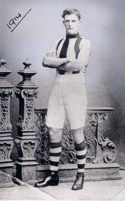
Photograph - Black and white, c.1914
This image is of Arthur Dawson, a well-known local footballer who played for the Fitzroy, St Kilda, Brighton and Moorabbin Football Clubs. As the villages of the Moorabbin area continued to grow and establish, sporting teams for both men and women were created and competitions played. Arthur Dawson went on to play for St. Kilda Football Club in the VFL in 1918, 1919 and 1921. His jumper numbers were 30 and 20. Black and white photograph of a young man wearing a striped football jersey, white shorts, striped knee-high socks and boots. He has his arms crossed and is standing in front of an ornate fence. The date 1914 is underlined in the top lefthand cornerHandwritten in red ink: 30%football, moorabbin, leisure, sport -
 City of Kingston
Photograph - Digital image, c.1918
Roderick William Mills, known as Saltbush Bill, was the inspiration for several poems by A.B. Paterson. Born at Balnarring in 1869, Mills earned the title of Saltbush Bill whilst working on a cattle station in Queensland. On these long droving trips, he learnt the art of cracking stock whips of many different lengths and sizes, a skill that earnt him £100 after a Melbourne saddler, J.K. Jennings, suggested that no man could crack a 65-foot stock whip in three tries. Saltbush Bill succeeded on his first attempt and decided to make a career in entertainment with his skill. Over his career he performed for royalty, travelled and performed extensively overseas and lent his skill to fundraising efforts, particularly during the war. His last concert was given in the Boomerang Hall in Dandenong in 1926.A local resident of the City of Moorabbin, Saltbush Bill was an ambassador for Australia and a literary inspiration to A.B. (Banjo) Paterson. Saltbush Bill, his wife Hannah Louise Porter and their 11 children lived in Old Dandenong Road, Heatherton, where Saltbush Bill and Hannah conducted a market garden for many years. Saltbush Bill is buried in Cheltenham's Pioneer Cemetery.Black and white digital imageheatherton, banjo paterson, saltbush bill, stock whip, entertainment -
 City of Kingston
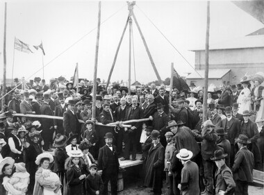
Photograph - Black and white, 1909
In 1880, the Melbourne Benevolent Asylum launched an appeal to raise funds to relocate away from the inner city. The location in North Melbourne was considered a great risk for the residents, particularly the 'old and feeble', in the event of an epidemic. In 1887, the secretary to the Premier of Victoria wrote to the Asylum, suggesting Frankston as a possible alternative to North Melbourne. The Asylum committee considered Frankston to be too far away. The Royal Commission into Charitable Organisations (1890) strongly recommended Cheltenham as the preferred location but the government failed to act on that recommendation. Former Asylum committee member, Mr James Hingston, bequeathed £25,000 to the Asylum on his death in 1902. After many more years of toing and froing, the foundation stone for the new asylum at Cheltenham was laid in 1909. It was almost two years later that the transfer of residents from North Melbourne to Cheltenham began. The move happened in stages over three days, with the first group of residents to move to Cheltenham being 125 women from the invalid wards. The Asylum continued to operate throughout the 20th Century and, in 1970, was renamed the Kingston Centre. The focus of services also changed. This photograph captures the laying of the foundation stone in 1909.Black and white image depicting a large group of citizens gathered to watch the laying of the foundation stone for the Benevolent Asylum in Cheltenham. There is a raised platform with a group of men dressed in suits standing on it. These appear to be the dignitaries for the day. There are flags flying in the background, others standing on poles at the corners of the raised platform. Handwritten in red ink on reverse: 50%cheltenham, charity, north melbourne, welfare -
 City of Kingston
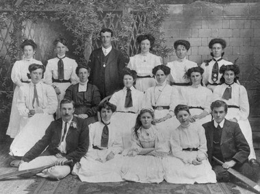
Photograph - Black and white
Black and white image of thirteen (13) women dressed in white blouses and skirts, in three rows. The front row of women are sitting on the floor and flanked by men dressed in suits, holding cricket bats across their knees. The middle row are seated and a woman dressed in dark clothes is seated second from left. The back row are standing and man dressed in a suit is standing, third from left. Four women have been identified in the back row (L - R): M Howard, L Ward, G Parry and R Gays.cricket, sport, women, team -
 City of Kingston
Photograph - Black and white, c.1917
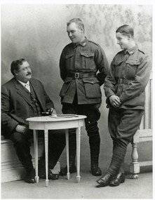
Roderick William Mills, known as Saltbush Bill (left) with his sons, James Charles Mills (centre) and John James Mills (right), in London. In 1917 Saltbush Bill travelled from America to London after giving shows in various cities of the US, to spend time with his sons. James and John Mills were serving with the AIF and on leave from the French front in London. Saltbush Bill remained in London for the rest of the war as he was unable to return to Australia. Saltbush Bill, was the inspiration for several poems by A.B. Paterson. Born at Balnarring in 1869, Mills earned the title of Saltbush Bill whilst working on a cattle station in Queensland. On these long droving trips, he learnt the art of cracking stock whips of many different lengths and sizes, a skill that earnt him £100 after a Melbourne saddler, J.K. Jennings, suggested that no man could crack a 65-foot stock whip in three tries. Saltbush Bill succeeded on his first attempt and decided to make a career in entertainment with his skill. Over his career he performed for royalty, travelled and performed extensively overseas and lent his skill to fundraising efforts, particularly during the war. His last concert was given in the Boomerang Hall in Dandenong in 1926.A local resident of the City of Moorabbin, Saltbush Bill was an ambassador for Australia and a literary inspiration to A.B. (Banjo) Paterson. Saltbush Bill, his wife Hannah Louise Porter and their 11 children lived in Old Dandenong Road, Heatherton, where Saltbush Bill and Hannah conducted a market garden for many years. Saltbush Bill is buried in Cheltenham's Pioneer Cemetery.Black and white photograph of three men, one seated behind a table and two standing. The two standing are in military uniformsHandwritten in blue ink: K000733saltbush bill, stock whip, entertainment, heatherton -
 City of Kingston
Photograph - Black and white, 1962
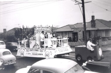
Crofts Stores (a chain of grocery stores) entered this float in the City of Moorabbin centenary procession held in 1962. Crofts had several stores in the City of MoorabbinCrofts Stores was established by Archibald Crofts with a single grocers store in South Melbourne. It eventually expanded to include 137 branches throughout Victoria, trading as Crofts Stores. Several Crofts stores existed in the City of Moorabbin and the chain pioneered self-service food stores in Australia. In 1962 the City of Moorabbin celebrated its centenary, which was marked with a procession through the streetsBlack and white photograph of a float being driven down a busy street. There are five people aboard the float, three behind a counter, and two at the rear. There are small flags reading Crofts (the business name) all around the float. Signage along the long edge of the float reads 'Crofts Stores congratulates the City of Moorabbin 1962'. Signage along the front shorter side reads 'Famous for fine foods', and signage above the counter reads 'Your grocer 1962'. There are people visible on the front porch of a house in the background, watching the float pass. Cars are parked along either side of the road and are also travelling in the opposite direction to the float.Handwritten in red ink: 60%grocery, centenary, city of moorabbin -
 City of Kingston
Photograph - Black and white, c.1960
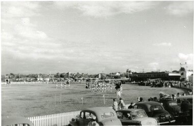
This photograph shows the Linton Street oval in Moorabbin in the early 1960's before it was redeveloped to become the home ground and club headquarters of the St Kilda Football ClubThe arrival of the St Kilda Football Club to Moorabbin was a significant event in the social and commercial development of Moorabbin. The presence of a VFL football team in the community created a sense of identity and belonging for many. Black and white photograph of a sporting oval. There are people on the field and more people lining the outside edge of the field. A row of parked cars is visible across the foreground.Handwritten in red ink: 60%city of moorabbin, moorabbin, st kilda football club, linton street oval -
 City of Kingston
Photograph - Digital image, July 1939
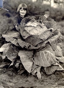
Kathleen Gartside with a cabbage grown by her father Jack Gartside on their property located on Centre Dandenong Road, Dingley. The Gartside family home was located opposite the Kingswood Golf Club in Dingley. The cabbage has a circumference of 12 feet, whilst the cabbage heart has a circumference of four feet. The Gartside family were a prominent local Dingley family, owning large market gardens and operating Gartside Bros Pty Ltd, a straight vegetable cannery employing large numbers of people. They were also keen golfers and around 1937, they leased 126 acres of their land to the Kingswood Golf Club. Jack Gartside moved his family home to the other side of Centre Dandenong Road, so that the Kingswood Clubhouse could be built. The first official games were played at Kingswood in March 1937. Black and white image of a young girl standing behind a large cabbagemarket garden, dingley, kingswood golf club -
 City of Kingston
Photograph - Black and white, c.1945
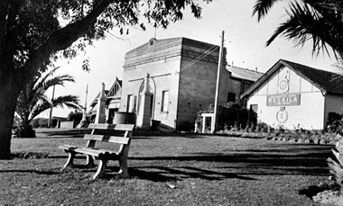
This photograph shows the Protestant Hall on Nepean Highway Cheltenham, which at the time of the photograph was used by the Returned Sailors' Soldiers' and Aimen's Imperial Leage of Australia (RSSAILA). The building facade, World War I memorials, fire station building and road plantation are also in view. The Protestants Hall was built by the Cheltenham Protestant Hall Company Limited in 1886. The hall has been used for a wide variety of purposes; in earlier times it served as the Sunday School for the Methodist Home for Children, and later as a schoolhouse when the Beaumaris School (now Cheltenham State School) No 84 met with overcrowding problems. It was also a popular venue for annual balls and regular dances held by church groups and sporting organisations. The City of Moorabbin purchased the building in the 1920's for use by the Returned Soldiers and Sailors League, in whose hands it remained until the late 1970s when it was taken over by a catering firm. During the 1920s, and right up to the late 1950s, it also served as Cheltenham's picture theatre. The three memorial columns, one from the South African War, one from World War I and one from World War II previously located in front of the hall were relocated when Nepean Highway was widened. The Protestant Hall still stands at 1261 Nepean Highway CheltenhamBlack and white digital image depicting three buildings. The right hand building bears a sign that reads RSSAILA. There are trees and a bench seat in the foreground. There is a World War I memorial pictured. world war i, world war ii, protestant hall, cheltenham, returned sailors' soldiers' and aimen's imperial leage of australia (rssaila), returned and service's league (rsl) -
 City of Kingston
Photograph - Digital image, c. 1900
Aged 17, Edwin Thomas Penny took over the 10 acres of freehold land held by his deceased father, Thomas Penny. Edwin Penny developed a reputation as an innovative orchardist and market gardener who grew apples, plums, passion fruit, peaches, pears, and lemons, and between the trees he planted potatoes, rhubarb and other vegetables.Sepia toned digital image of the Penny family. Back row left to right: Clifford Penny, Reubin Penny, Edwin Penny. Front row left to right: Albert Penny, Edwin Thomas Penny, Hilda Penny and Lytton Pennymarket garden, orchards, fruit, vegetables, moorabbin, cheltenham -
 City of Kingston
Pamphlet - Black and white, Robert McCamish & John Gilpin (Vendors), For Private Sale Station Entrance Estate, Highett, 1930s
Sales plan for land in the suburb of Highett, bounded by Wickham Road, Railway Parade, Highett Road and Point Nepean Street. The developing urban area of Highett within the City of Kingston. This land sale pamphlet illustrates the subdivision of land within the municipality and the changing demographic of the district as new houses are constructed. The extension of the railway line from the city to Mordialloc opened up the land for development.Black and white pamphlet advertising for private sale the Station Entrance Estate, Highett. Incorporates a map of the estate bordered by Wickham Road, Railway Parade, Highett Road and Point Nepean Road. Handwritten in black ink on reverse: Station Entrance / Estate / Late [indecipherable]highett, land sales, estate -
 City of Kingston
Pamphlet - Colour, Stillwell and Co, The Hill Estate Highett Great Subdivisional Auction Sale, 1917
Sales plan for land in the suburb of Highett, bounded by Point Nepean Road and incorporating Sandford Street, Turner Road, Alfred Street, Peace Street and Tennyson Street. .The developing urban area of Highett within the City of Kingston. This land sale pamphlet illustrates the subdivision of land within the municipality and the changing demographic of the district as new houses are constructed.Colour pamphlet advertising subdivisional auction sale of the Hill Estate Highett. Incorporates a map of the estate bordered by Point Nepean Road and encompassing Sandford Street, Turner Road, Alfred Street, Peace Street and Tennyson St. Handwritten in grey pencil on reverse: Hill Street / Jamieson Handwritten in blue pencil on reverse: The Hill Estate Handwritten in blue pencil on subdivision map: [tick] [on majority of properties marked on map]highett, land sales, estate -
 City of Kingston
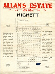
Pamphlet - Colour, Allan's Estate Highett, 1930s
Sales plan for land in the suburb of Highett, bounded by Spring Road, Highett Road and Worthing Terrace.The developing urban area of Highett within the City of Kingston. This land sale pamphlet illustrates the subdivision of land within the municipality and the changing demographic of the district as new houses are constructed.Colour pamphlet advertising Allan's Estate, Highett. Incorporates a map of the estate bordered by Spring Road, Highett Road and Worthing Terrace.Handwritten in grey pencil on reverse: Allan's Estate / Highett Crossed out in blue pencil on front: Name and address of what appears to be a solicitorhighett, land sales, estate -
 City of Kingston
Pamphlet - Colour, R. Malcolm Estate Agents et al, Last Chance Land Sale Heritage Estate Cheltenham, c.1994
Sales plan for land in the suburb of Cheltenham, bounded by Chesterville Road and Bernard Street, and incorporating Clendon Court, Tintern Grove and Tintern MewsThis land sale pamphlet illustrates one of the last subdivisions of the century in Cheltenham, incorporating house and land packages. It shows that land sales and subdivision for the area had slowed considerably by the end of the 1900s and that the infrastructure was significantly developed. Colour pamphlet advertising last chance land sale of Heritage Estate Cheltenham. Incorporates a map of the estate bordered by Chesterville Road and Bernard Street, and including Clenton Court, Tintern Grove and Tintern Mews.cheltenham, land sales, estate -
 City of Kingston
Pamphlet - Colour, W. H. Wood Estate Agent, Subdivisional Land Auction Barker's Estate Cheltenham, 1919
Sales plan for land in the suburb of Cheltenham, along Barker StreetThe developing urban area of Cheltenham within the City of Kingston. This land sale pamphlet illustrates the subdivision of land within the municipality and the changing demographic of the district as new houses are constructed.Colour pamphlet advertising subdivisional land auction of Barker's estate, on Barker Street Cheltenham.Handwritten in grey pencil on the subdivision map: a series of numbers on each block possibly indicating the sale price. Handwritten in grey pencil on the subdivision map: Roy- joined to subdivision 6 Handwritten in grey pencil on the subdivision map: x on the border between subdivision 17 and 16, and again on the border between subdivision 12 and 11.cheltenham, land sales, estate -
 City of Kingston
Photograph - Digital image, Colour, City of Kingston (Graham Whitehead)
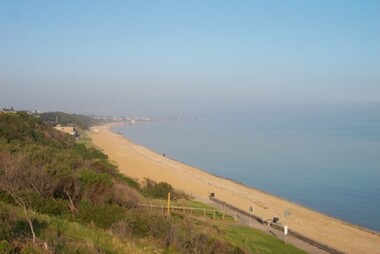
Colour image of Mentone foreshore looking towards Mordialloc. The natural environment of Kingston significantly impacted its development. The bay was a source of food and income, as well as a holiday destination. Colour image of Mentone beach looking towards Mordialloc, with Mentone life saving club in distance.mentone, beach, environment -
 City of Kingston
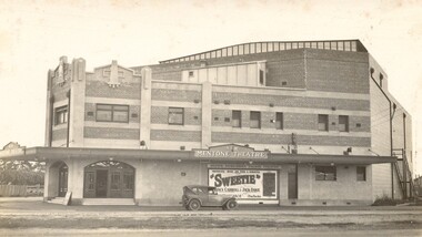
Photograph - Digital image, Black and white, c.1928
Image of the newly opened Mentone Picture Theatre located on Point Nepean Road in Mentone. Local picture theatres abounded in the in the suburbs of Kingston from the 1920s through to the late 1950s. The New Mentone Picture Theatre was dreamt up and developed by Albert Lydford who along with other promoters, formed a company that provided the finance for the erection of a large cinema right at the junction of Balcombe Road and Point Nepean Road. The New Mentone Picture Theatre operated in competition with a council owned facility on Brindisi Street and within three years of opening, the council theatre was closed. The New Mentone Theatre flourished until the late 1950s. It offered three changes of program each week. Two movies screened on Mondays and Tuesdays. On Wednesday a new bill went on for just one night, and then the main feature of the week, a movie the likes of Casablanca, was shown from Thursday through to Saturday. During its heyday there were full houses almost weekly. Saturday night shows were often booked out in advance and some families had permanent bookings at weekends. Locals treated the place as a centre of social activity, a venue for an enjoyable night out that did not involve great expense or long travel times. The advent of television in the 1950's, saw the theatre close forever in 1960.Sepia toned image of the New Mentone Picture Theatre, located on Point Nepean Road, Mentone.theatre, movies, mentone, entertainment -
 City of Kingston
Photograph - Digital image, Black and white, c. 1910
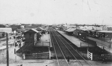
Black and white image of Chelsea Railway Station showing the impact of the railways on the development of the area. Shops and shoppers can be seen behind the station buildings.The extension of the railway line from Mordialloc to Frankston influenced the development of the villages along the train line. Shops and community buildings were built in proximity to the station, along with the subdivision of land for houses. Black and white image of Chelsea Railway Station showing platforms and local shopschelsea, railway station, railway, shopping strip, public transport -
 City of Kingston
Photograph - Digital image, Black and white, c. 1950
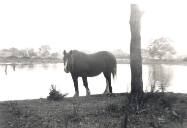
Horse standing by a lake on the property of the Methodist Children's Homes, Cheltenham. The photograph is taken from Tennyson Street, looking towards Point Nepean Road.This image shows the land in Cheltenham, that later became Southland Shopping Centre. The land originally belonged to the Methodist Church, who operated a Children's Home on the property.Black and white image of a horse standing next to a tree trunk by a lake. cheltenham, methodist children's homes, southland, environment -
 City of Kingston
Pamphlet - Black and white, Stott & Burke, Highland Estate Bentleigh, c.1915
Sales plan for land in the suburb of Bentleigh, along Collins and Ross Streets, bounded by Jasper Road.The developing urban area of Bentleigh within the City of Kingston. This land sale pamphlet illustrates the subdivision of land within the municipality and the changing demographic of the district as new houses are constructed.Black and white pamphlet advertising for private sale the Highland Estate, Bentleigh. Incorporates a map of the estate between Collins St and Ross St, bordered by Japser Road. Handwritten in grey pencil on map: additional subdivisions numbered 15-19 drawn along Ross St Handwritten in grey pencil on map: indecipherable annotations to subdivisions 1, 3 and 14land sales, bentleigh, estate -
 City of Kingston
Pamphlet - Colour, Ozone Hill Estate, Cheltenham, 1923
Sales plan for land in the suburb of Cheltenham, along both sides of Victori Avenue, off Weatherall Road.The developing urban area of Cheltenham within the City of Kingston. This land sale pamphlet illustrates the subdivision of land within the municipality and the changing demographic of the district as new houses are constructed.Colour pamphlet advertising for sale the Ozone Hill Estate, Cheltenham. Incorporates a map of the estate on either side of Victor Avenue, off Weatherall Road. Handwritten in blue ink on the subdivision map: 'Sold' is written on subdivisions 1-4, 8, 11, 13, 16-26, 28, 29, 33, 39-41 Handwritten in blue ink on the subdivision map: 'House being erected' is written on subdivisions 22 and 33. Handwrittten in grey pencil adjacent to subdivisions 21 and 22: Tennis / Courts / being / constructed / here Handwritten in grey pencil at bottom of page: Revised to 30/1/24 Handwritten in grey pencil on subdivision map: assumed land sale price is recorded on subdivisions 5-9, 9-10, 12, 14-15, 27, 30-32, 34-38. land sales, cheltenham, estate -
 City of Kingston
Pamphlet - Colour, H. R. Hill & Co, Walker's Estate, Cheltenham for sale by public auction, c. 1923
Sales plan for land in the suburb of Cheltenham, encompassing both sides of Walker Grove, a section of Centre Dandenong Rd and Axelton St. The developing urban area of Cheltenham within the City of Kingston. This land sale pamphlet illustrates the subdivision of land within the municipality and the changing demographic of the district as new houses are constructed.Black and white pamphlet advertising for private sale the Station Entrance Estate, Highett. Incorporates a map of the estate bordered by Wickham Road, Railway Parade, Highett Road and Point Nepean Road.Handwritten in black pen on subdivision map: 'x' written on subdivisions 2, 3, 8-11, 15-17, 19. Potentially indicating that these properties did not sell at auction. Handwritten in black pen on subdivision map: assumed sale price on subdivisions 1, 4-7, 12-14, 18, 20-31. land sales, cheltenham, estate -
 City of Kingston
Pamphlet - Colour, Stillwell and Co, Cheltenham Charman Estate Realising Auction, 1921
Sales plan for land in the suburb of Cheltenham, along Charman Road and Weatherall Street.The developing urban area of Cheltenham within the City of Kingston. This land sale pamphlet illustrates the subdivision of land within the municipality and the changing demographic of the district as new houses are constructed.Colour pamphlet advertising realising auction of the Charman Estate, Cheltenham. Incorporates a map of the estate, showing subdivisions along Charman Road and Weatherall Street.land sales, cheltenham, estate -
 City of Kingston
Pamphlet - Colour, Duffus Bros, Railway Reserve Highett, c. 1923
Sales plan for land in the suburb of Highett, titled Railway Reserve, incorporating properties along Wolseley Street, Livingston Street, Highett Road and Worthing Road. The developing urban area of Highett within the City of Kingston. This land sale pamphlet illustrates the subdivision of land within the municipality and the changing demographic of the district as new houses and shops are constructed close to infrastructure.Colour pamphlet advertising thirty eight shop and villa sites for sale at the Railway Reserve, Highett. Incorporates a map of the reserve with properties available on Wolseley Street, Livingston Street, Highett Road and Worthing Road. Handwritten in grey pencil: assumed sale price recorded on subdivisions 1-7, 10, 22, 23 and 34 Handwritten in grey pencil on subdivision 4: C. Nevill / City of Melbourne bank Handwritten in grey pencil across subdivision 7: 49' Handwritten in grey pencil across subdivision 21 and 22: 134' Handwritten in grey pencil across subdivision 25 and 26: 200' Handwritten in grey pencil across subdivision 36 and 37 and both top and bottom: 120' Hand drawn in blue pencil: outline of subdivision 4 Hand drawn in blue pencil: outline of subdivisions 7, 23, 28, 37, 38 along left hand side, subdivisions 38, 37 and 36 on Wolseley Street, subdivisions 30 and 29 along Wolseley Street, subdivisions 29 and 24 along the middle of the plan, subdivisions 24 and half of 25 along Livingston Street, half of subdivision 20 along the middle of the plan, subdivisions 21 and 22 along the Right of Way between Livingston Street and Highett Road, and along the right hand border of subdivision 7. Handwritten in ink adjacent to the subdivision plan, updside down, in the bottom right hand corner: 276 / 54 / 280 / 45 / 320 / 202 / 200 / 134 / horizontal line / 11/14 Handwritten in ink adjacent to the subdivision plan, updside down, in the bottom right hand corner: 1714)2200(15 / 1714 / horizontal line / 486land sales, highett -
 City of Kingston
Pamphlet - Colour, Roy Dunn Pty. Ltd, Central Corner Estate Moorabbin and Highett, c. 1923
Sales plan for land in the suburbs of Highett and Moorabbin, bordered by Point Nepean Road and Wickham Road East incorporating William StreetThe developing urban area of Highett and Moorabbin within the City of Kingston. This land sale pamphlet illustrates the subdivision of land within the municipality and the changing demographic of the district as new houses are constructed close to infrastructure.Colour pamphlet advertising for private sale land in the Central Corner Estate in Moorabbin and Highett. Incorporates a map of the estate bordered by Point Nepean Road and Wickham Road East, with subdivisions also available on both sides of William Street. Handwritten in blue pencil on subdivision plan: a tick is drawn on subdivisions 2-18 Handwritten in blue pencil on subdivision 6: a box with an x inside Handwritten in blue pencil on subdivisions 10 and 12: S Handwritten in black ink on front page: [indecipherable] / McKittricks Handwritten in grey pencil on rear page: McKilhick / Nepean Rd Handwritten in grey pencil on rear page upside down: 160000 / 15 8300 [crossed out] land sales, estate, highett, moorabbin -
 City of Kingston
Pamphlet - Colour, Roy Dunn Pty. Ltd, Subdivisional auction of Highett Station Estate, c.1924
Sales plan for land in the suburb of Highett, bounded by Worthing Road, and the Melbourne to Frankston Electric Railway Line, including LePage Street. The developing urban area of Highett within the City of Kingston. This land sale pamphlet illustrates the subdivision of land within the municipality and the changing demographic of the district as new houses are constructed close to infrastructure.Colour pamphlet advertising a subdivisional auction of the Highett Station Estate. Incorporates a map of the estate bordered by Worthing Road and the Melbourne to Frankston Electric Railway, and including LePage Street. Handwritten in black ink on front cover: Late LePage / Wickham Rdland sales, estate, highett -
 City of Kingston
Pamphlet - Colour, W. H. Wood Estate Agent, Realising sub-divisional auction sale Bentleigh Park Estate, Bentleigh, 1920
Sales plan for land in the suburb of Bentleigh, bounded by Centre Road, and incorporating subdivisions on either side of Elizabeth Street (Wheatley Road), Oak Street and Beech Street.The developing urban area of Bentleigh within the City of Kingston. This land sale pamphlet illustrates the subdivision of land within the municipality and the changing demographic of the district as new houses are constructed close to infrastructure.Colour pamphlet advertising a realising sub-divisional auction sale of the Bentleigh Park Estate, Bentleigh. Incorporates a map of the estate bordered by Centre Road, and including Elizabeth Street (Wheatley Road), Oak Street and Beech Street.Hand drawn in grey pencil: a small square on subdivision 33 Hand drawn in grey pencil: a small square incorporating a cross on subdivision 24 Hand written in black ink on reverse: Bentleigh Park / Estate / Ward late Andersonsland sales, estate, bentleigh -
 City of Kingston
Pamphlet - Colour, T. H. Ould Publishing Co, The Ridge Estate, Cheltenham, c. 1930
Sales plan for land in the suburb of Cheltenham, bounded by Johnston Street, Silver Street and Cavanagh Street, incorporating lots on either side of Sunray Avenue.The developing urban area of Cheltenham within the City of Kingston. This land sale pamphlet illustrates the subdivision of land within the municipality and the changing demographic of the district as new houses are constructed close to infrastructure.Colour pamphlet advertising for sale lots in The Ridge Entrance Estate, Cheltenham. Incorporates a map of the estate bordered by Johnston Street, Silver Street and Cavanagh Street, including subdivision lots on either side of Sunray Avenueland sales, estate, cheltenham -
 City of Kingston
Pamphlet - Colour, S. M. Reynolds, Estate Agent, Moorabbin Shire Hall Estate Second Section, c. 1930
Sales plan for land in the suburb of Moorabbin, bounded by South Road and Highbury Street, including Prince Street, Charming Street, Thomas Avenue and Keith Road.The developing urban area of Moorabbin within the City of Kingston. This land sale pamphlet illustrates the subdivision of land within the municipality and the changing demographic of the district as new houses are constructed close to infrastructure.Colour pamphlet advertising for private sale the Moorabbin Shire Hall Estate, Moorabbin. Incorporates a map of the estate bordered by South Road and Highbury Street, including Prince Street, Charming Street, Keith Road and Thomas Avenue.Handwritten in grey pencil on subdivision map below subdivision 63: £4 Handwritten in grey pencil on subdivision map below subdivision 66: 4 Handwritten in grey pencil on subdivision map below subdivision 80: 3. Handwritten in grey pencil on subdivision map below subdivision 81: 4 Handwritten in grey pencil on subdivision map below subdivision 83: 2 Handwritten in grey pencil on subdivision map below subdivision 96: £3 Handwritten in grey pencil on subdivision map below subdivision 97: 3 Handwritten in grey pencil on subdivision map to the left of subdivision 102: 3 Handwritten in grey pencil on subdivision map on the corner of Thomas Avenue and Highbury Street: vertical line next to a square with a cross in it.land sales, estate, moorabbin -
 City of Kingston
Pamphlet - Colour, Fergusson & Mitchell Lith, Sandringham Rises, c. 1888
Sales plan for land in the suburb of Sandringham, bounded by Bluff Road, Bay Road and William Street, and incorporating Frances Street.The developing urban area of Highett (then called Sandringham) within the City of Kingston. This land sale pamphlet illustrates the subdivision of land within the municipality and the changing demographic of the district as new houses are constructed close to infrastructure.Colour pamphlet advertising for sale 35 lots in Sandringham Rises, Sandringham. Incorporates a map of the estate bordered by Bluff Road, Bay Road and William Street, including Frances Street.Handwritten in grey pencil next to the words 'THREE O'CLOCK': 1888 Handwritten in blue ben next to the words '& BUSINESS SITES': 1888land sales, sandringham, highett