Showing 1526 items
matching aerial photograph
-
 Lakes Entrance Historical Society
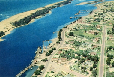
Photograph - Lakes Entrance, 1960c
... Colour photograph aerial view of the township, shows also... photograph aerial view of the township, shows also Cunninghame Arm ...Copied from postcardColour photograph aerial view of the township, shows also Cunninghame Arm, the hummocks and distant view of Bullock Island and the entrance. Lakes Entrance Victoria hotels, township, waterways -
 Sunshine and District Historical Society Incorporated
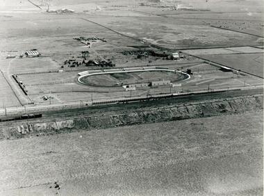
Photographs - WHITE CITY, Pratt, Charles Daniel, (1892 - 1968)
... Two low aerial photographs of the White City Coursing.... We do not hold a copy of these. Two low aerial photographs ...The White City Greyhound racing stadium was built at Tottenham in 1927, with the intention that mechanical lures and not live hares be used as pacemakers. The first meeting was held on 10 December 1927 but within 3 days, after strong lobbying by other sports bodies, the Victorian Government banned betting on greyhound racing if mechanical lures were used instead of live hares. This caused some financial problems to the shareholders. For a time the average weekly attendances were 9000, and races were held on Mondays, Wednesdays, and Saturdays. Whippet Races, Goat Races, Monkeys on greyhounds, and Professional Foot racing were also tried to attract attendances. After 28 years of bureaucratic interference, and using live hares as greyhound pacemakers, the White City stadium held its last meeting on 29 December 1955. On 31 December the Victorian Government finally allowed betting on greyhound races that used mechanical lures. Manufacturing industry (Olex Cables) took over the White City site. Transport to the White City stadium was provided by train, with only a single platform available on the Down side of Tottenham, even though double train lines existed. Special train services were run from Flinders Street to the White City platform, and for a while a parcels coach was provided for the transport of dogs. As industry developed in the area some trains also stopped at the White City platform in the mornings and late afternoons to transport workers. In 1981 when the grade separation at Ashley Street next to the Tottenham station was completed, the new train lines on the Upper Level came into operation, and so the White City platform was closed down and eventually demolished. The above historical information was sourced from the booklet "GOING TO THE DOGS" by Tom Rigg.Greyhound racing has always been popular in Melbourne's western suburbs. The White City stadium in Tottenham was a major centre for the sport until 1955, enabling those who could not afford race horses to take part in an animal racing sport. The demolition of first the stadium and years later the railway platform, has relegated the name White City and its past relevance to the western suburbs, into history.Two low aerial photographs of the White City Coursing stadium (Greyhound racing), plus a CD containing the same two images as well as a few other local images. The Coursing stadium was located about 500 metres from the Tottenham railway station on the down line towards Sunshine station. The photographs are thought to be from circa late 1920's to early 1930's, and one shows the view from the north facing south, while the other from the west facing east. The latter also shows built up areas of West Footscray and beyond.Only on the negatives at the State Library. We do not hold a copy of these.white city, greyhound racing stadium, coursing track, white city station, tottenham, whippet, gambling, live hare, mechanical lure -
 Bendigo Military Museum
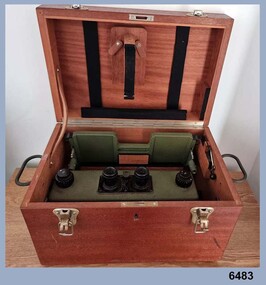
Instrument - Old Delft Scanning Stereoscope ODSS III, C. 1956
... the aerial photographs. In the public and private sector it was also... the aerial photographs. In the public and private sector it was also ...This is a superbly crafted cartographic mapping instrument. It is housed in its own high-quality purpose-built oak box. Made in the Netherlands from 1950 onwards. This instrument is from c 1956. it is a very high-quality military grade stereoscope that was generally used by photographic interpreters such as intelligence analysts but was equally useful for mapping activities. The stereoscope was used to examine 3D aerial photographic images. This instrument has a particularly useful capability to scan over the 3D stereo model using X and Y movement knobs, rather than having to physically move the aerial photographs. In the public and private sector it was also useful for photogrammetric interpretation for Forestry and Agricultural purposes. See also Bendigo RSL Collections Victoria item Number 6205.6P that shows the Old Deft Stereoscope in use at the Army Survey Regiment, Bendigo.This is an "Old Delft" scanning stereoscope with its reflecting carriage and legs. The Stereoscope is housed in its own purpose built wooden oak box that has dovetail joints, 2 x securing clips, 2 x handles and a lock (without key). The instrument is assembled by inserting colour coded legs into their matching slots."OLD DELFT SCANNING STEREOSCOPE ODSS III" "Patents Applied for" "OLD DELFT C4790" "MADE IN THE NETHERLANDS"royal australian survey corps, rasvy, fortuna, army survey regiment, army svy regt, asr -
 National Vietnam Veterans Museum (NVVM)
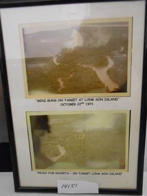
Photograph, Air Attack at Long Son Island, 22/10/1971 12:00:00 AM
... Two Black Framed colour Photograph of Aerial attack on Long... Island Aerial attack Two Black Framed colour Photograph of Aerial ...Two Black Framed colour Photograph of Aerial attack on Long Son Island on October 22 1971photograph, long son island, aerial attack -
 Port Fairy Historical Society Museum and Archives
Photograph
... Black and white photograph of aerial view Caledonian... victoria hotel Black and white photograph of aerial view Caledonian ...SE view from St Johns Tower 1973Black and white photograph of aerial view Caledonian & Victoria Hotels centre. Reardon theatre far leftst john's tower, tower, st johns, town, aerial, caledonian, victoria, hotel -
 Ringwood and District Historical Society
Article - Newspaper Clipping, Land Sale Advertisements, Golden Hill Estate, Ringwood - 1965, 1966, and Plan of Survey of Lot 8, Mullum Mullum Road Ringwood, 1970
... - Golden Hill Estate, Ringwood, with summary of features and aerial..., Ringwood, with summary of features and aerial photograph including ...Newspaper clippings from Melbourne Sun newspaper (11th December 1965 and 15th January 1966) advertising sale of land - Golden Hill Estate, Ringwood, with summary of features and aerial photograph including artistic representation of street layout. Subdivision includes Mullum Mullum Road, Sonia Street, Jill Court, Linda Drive, Eve Court, Alma Court, and Jacynthe Court. Attachments include reference to Lot 46 as site of original Peter Vergers' orchard residence and subsequent 1970 surveyor's Plan of Survey of Lot 8 Mullum Mullum Road Ringwood, LP 67513, Cert of Title 8581/429.Agent - Aaron, King & Co., Suite 2, 33 Queens Road, Melbourne. (Phone) 26-2443, A.H. 850-2195. Plan of Survey signed on 25.7.1970 by Roger M. Gamble, Land Surveyor, 28 Summit Crescent, Ringwood 3134. -
 Federation University Historical Collection
Booklet, Ballarat School of Mines, Ballarat School Of Mines Agenda for meeting with Chairman of the TAFE Board, 07/1985
... * Uncertainties Re Blackburn The booklet also includes an aerial... The booklet also includes an aerial photograph of the Ballarat School ...Yellow covered A$ booklet bound with plastic. The book as in agenda for a meeting with I. Predl, acting Chairman of the TAFE Board. Items for discussion were: * L.F.J. Hillman Recreation Building * Maintenance of Buildings * Campus titles and future development * Quality Improvements * College Management Study * Uncertainties Re Blackburn The booklet also includes an aerial photograph of the Ballarat School of Mines campus, including dates each building was erected. The image shows the site of the newly demolished Ballarat Gao, and still has a tennis court and Mining laboratory onsite. The book also show allotment plans of the Ballarat School of Mines site. -
City of Kingston
Photograph - Colour, 29 January 1993
... Laminated colour aerial photograph of the suburb... Laminated colour aerial photograph of the suburb of Bonbeach ...Bonbeach is a small beachside suburb located between Chelsea and Carrum. The station was opened in 1926 and was the last to be established in the group from Aspendale to Carrum. Urban growth began after World War II. State primary and high schools were opened in 1958 on land in Breeze Street that was once occupied by The Australian Glass Manufacturers. Immediately east of the school sites is the Patterson River Golf Club. The Bonbeach sports reserve has five ovals and is home to the Bonbeach football and baseball clubs. The suburb borders the Edithvale-Seaford Wetlands which is the remnant site of the Carrum Carrum swamp, once the home of the Bunurong people.Bonbeach was originally a seaside destination for holidaymakers and the housing comprised of holiday homes and gradually more permanent residents. It was not until 1926 that Bonbeach had its own railway station. From 1906 until the late 1940s sand was quarried on the east side of the railway line and used in the manufacture of glass. The Australian Glass Manufacturers sold this land in residential blocks and Bonbeach's permanent population spread from the coastal strip across to the other side of the railway line. Laminated colour aerial photograph of the suburb of Bonbeach and also the southern section of neighbouring Chelsea within the City of Kingston. The extent of this 1993 aerial image includes: Top left - Maury Road at the south end of the Chelsea shopping Centre; Top right - Scotch Parade Chelsea Bottom left - Monica Avenue in Bonbeach; Bottom right - Patterson River Golf Club. Landmarks include St Joseph's Church and Primary School, Chelsea Primary School, Bonbeach Station, Bonbeach Fotball Club sports playing fields and Bonbeach Life Saving Club. The Edithvale Wetlands is featured prominently to the right-hand side of the image. Black typed writing on white adhesive label: No. 6662 Black typed writing on white adhesive label: 26E/6662, 29/1/93, 4.25 pm Black typed writing on white adhesive label: 29-1-93 Black typed writing on white adhesive label: P000109 Circular yellow adhesive sticker bonbeach, chelsea -
Glenelg Shire Council Cultural Collection
Photograph, View of Portland Harbour, c. 1974
... Black and white photograph. Aerial view taken from the west...) Black and white photograph. Aerial view taken from the west ...Port of Portland Authority archives.Front: (no inscriptions) Back: (no inscriptions) -
Glenelg Shire Council Cultural Collection
Photograph, View of Portland Harbour, c. 1974
... Black and white photograph. Aerial view taken from the west...: (no inscriptions) Back: (no inscriptions) Black and white photograph ...Port of Portland Authority archives.Front: (no inscriptions) Back: (no inscriptions)port of portland, henty park, fishing fleet -
Glenelg Shire Council Cultural Collection
Photograph - Photograph - View of Portland Harbour, c. 1974
... Black and white photograph. Aerial view taken from the west...: (no inscriptions) Back: (no inscriptions) Black and white photograph ...Port of Portland Authority archives.Front: (no inscriptions) Back: (no inscriptions)port of portland archives, portland harbour -
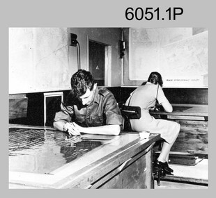 Bendigo Military Museum
Photograph - Retouching Reproduction Material at the Army Survey Regiment, c1960s, c1970s
... projecting a scaled projected aerial photograph as a positional... projecting a scaled projected aerial photograph as a positional ...The first four photographs were most likely taken in the 1960 and the fifth in the 1970s at the Army Survey Regiment, Fortuna, Bendigo. As there are no annotations with the photos, the exact dates, locations and names of personnel are unknown. SGT Bob Scaddan appears in the fifth photo taken in the 1970s Photos .1P and .2P. could have been taken in Lithographic Squadron’s retouching room and Photos .3P, .4P and .5P. were probably taken in Cartographic Squadron’s Correcting Section, located in the Attic. Retouching mainly entailed the application of liquid opaque (Plumtree), commonly known as “duff” to cover blemishes such as scratches and spots on film negatives before photographic exposure. Retouching technicians also used specialised techniques such as “needling” to repair faults on the emulsion of map reproduction material. The technician in photo .4P is needling a hydrographic feature on a drainage negative, with a zoom transfer scope projecting a scaled projected aerial photograph as a positional reference. This is a set of five photographs of technicians retouching reproduction material at the Army Survey Regiment, Bendigo. The photographs were printed on photographic paper and are part of the Army Survey Regiment’s Collection. The photographs were scanned at 300 dpi. .1) - Photo, black & white, c1960s. unidentified personnel in Lithographic Squadron. .2) - Photo, black & white, c1960s. unidentified personnel in Lithographic Squadron. .3) - Photo, black & white, c1960s. unidentified personnel in Cartographic Squadron Attic. .4) - Photo, black & white, c1960s. unidentified personnel in Cartographic Squadron Attic. .5) - Photo, black & white, c1970s. SGT Bob Scaddan in Cartographic Squadron..1P to .3P, .5P - annotated “Retouching”royal australian survey corps, rasvy, army survey regiment, army svy regt, fortuna, asr, litho, carto -
Port Melbourne Historical & Preservation Society
Photograph - Aerial view of cruise ships at Port Melbourne piers, 13 Feb 2001
... Aerial colour photograph taken by The Age, showing from... Silver Cloud Aerial colour photograph taken by The Age, showing ...This photograph records the concurrent visit to Station Pier of three cruise ships - the peak of the Cruising Victoria strategy aimed at encouraging cruise shipping to Melbourne. Also the Devil Cat was berthed at Station Pier on this day but not in the photo (4 ships in one day)Aerial colour photograph taken by The Age, showing from left to right, cruise ships Regal Princess, QE2 and Silver Cloud, all at Station Pier on 13 February 2001. An unusual persective showing the rear of 'The Anchorage', formerly Swallow and Ariell, also Stokes and Princes Streetspiers and wharves - station pier, transport - shipping, rms queen elizabeth 2, qe2, swallow & ariell ltd, regal princess, silver cloud -
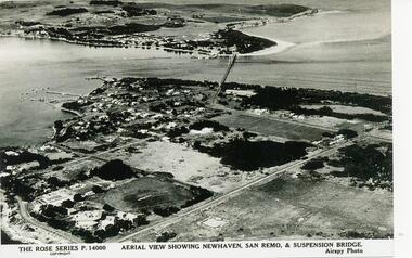 Phillip Island and District Historical Society Inc.
Photograph - Post Card, 1954
... Black & White photograph of aerial view over water and land... photograph of aerial view over water and land. Newhaven in foreground ...One of a collection of photographs donated by Daryl JohnsBlack & White photograph of aerial view over water and land. Newhaven in foreground and San Remo at rear of suspension bridge."The Rose Series P.14000. Aerial view showing Newhaven, San Remo & Suspension Bridge." Airspy Photo.phillip island, newhaven, san remo, daryl johns -
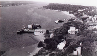
Glenelg Shire Council Cultural Collection
Photograph, c. 1967
... Unframed aerial black and white photograph, taken from...: Aerial view of section of Port and its surrounds Unframed aerial ...Port of Portland Authority archives On 19 November 1960, the Portland Harbour Trust was officially opened by His Excellency, The Governor of Victoria, Sir Dallas Brooks, in front of thousands of onlookers. It was one of the largest concentration of Premiers, Statesmen, industrial and civic leaders ever to attend an event outside of an Australian capital city. Today, Port of Portland is a busy modern port, handling in excess of $2 billion in trade. One of Victoria’s four major shipping ports, it handles bulk cargoes such as plantation woodchips and logs, grain, aluminium products, mineral sands, fertiliser, livestock and wind tower components.This forms part of the archives of the Port of Portland which were donated to the Glenelg Shire Cultural Collection by the Port of Portland. The collection documents the growth and significance of the Port of Portland.Back: Aerial view of section of Port and its surroundsport of portland, henty park, portland botanic gardens -
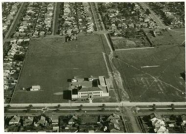 NMIT (Northern Melbourne Institute of TAFE)
Photographs: PTS Admin Building c1940s aerial view, Photographs: Preston Technical School Administration Building c1940s aerial view
... Two black and white photographs of aerial view of Building... Photographs: PTS Admin Building c1940s aerial view ...Two black and white photographs of aerial view of Building A (Administration Building) Preston campus of Preston Technical School c1940s. preston technical school, buildings, nmit -
 Ringwood and District Historical Society
Map - State Aerial Survey, Dandenong Ranges Area, Parishes of Warrandyte and Ringwood - 1956
... , July 1956, from aerial photographs and Cadastral Survey... aerial photographs and Cadastral Survey information. Subsequent ...Map of central and southern areas of Ringwood and part of Ringwood East and Heathmont compiled by Dept of Lands and Survey, July 1956, from aerial photographs and Cadastral Survey information. Subsequent hand-drawn addition of streets showing layout of "Township of Ballyduffy Estate 1858-60", an earlier proposed subdivision that did not eventuate. (See attached 5009b Ballyshanassy_ Melbourne’s lost suburb.pdf for Ballyduffy historical naming relevance). Ballyduffy Estate streets include City Road, West Prussia Road, Duffy Street, Ireland Street, Evans Street, Victoria Street, Regina Street, Short Road, Prussia Road, Duffy Street East, Ireland Street East, Evans Street East, Chapman Street. Misc Topo 93 Sheet 22, Ringwood A4B2. Scale: 4 chains to 1 inch. Contour interval 20 feet. -
Port Melbourne Historical & Preservation Society
Photograph - Photograph board, Seven aerial views of J Kitchen & Sons site, Port Melbourne, J Kitchen & Sons Pty Ltd. Port Melbourne 1951, 1951
... Photograph board, Seven aerial views of J Kitchen & Sons...Large brown cardboard with seven (7) B&W aerial photographs... Photograph Photograph board, Seven aerial views of J Kitchen & Sons ...Large brown cardboard with seven (7) B&W aerial photographs pasted on it. Taken in 1951. Photo 1 - South East direction with Boundary Street in foreground, Kitchens buildings and Football Ground (cricket being played) Photo 2 - South West direction towards the Bay showing Station and Princes Piers, with ships in the distance. Photo 3 - almost directly above Kitchens Photo 4 - directly above kitchens Photo 5 - looking West including the Yarra River Photo 6 - looking North with Kitchen's storage and football ground in foreground Photo 7 - looking north east with football ground in foregrpound left and Yarra River top right.industry - manufacturing, built environment - industrial, piers and wharves - princes pier, piers and wharves - station pier, sport - australian rules football, sport - cricket, sport - recreational grounds, j kitchen & sons pty ltd, port melbourne football and cricket ground, north port oval -
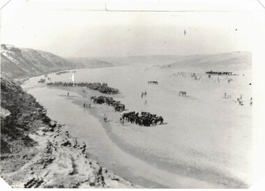 8th/13th Victorian Mounted Rifles Regimental Collection
Photograph - 8th LH in desert
... Aerial black and white photograph of light horse regiment... middle east Aerial black and white photograph of light horse ...The 8th Light Horse Regiment AIF was raised at Broadmeadows Victoria in September 1914 under the command of Lieutenant Colonel Alexander White and formed part of the 3rd Light Horse Brigade. The regiment served at Gallipoli where in a courageous but ill-fated charge at the Nek on 7 August 1915 it suffered horrendous casualties including Lieutenant Colonel White. Rebuilt in Egypt under the command of Lieutenant Colonel Leslie Maygar VC the regiment went on the serve throughout the Middle East Campaign. Colonel Maygar died of wounds at Beersheba when the regiment was attacked by enemy aircraft while waiting to follow up the successful charge of the 4th LH Brigade on 30 October 1917. The 8th Light Horse AIF was disbanded in 1919, but soon after re-raised as the 8th (Indi) Light Horse in the Citizen Military Forces, superseding 16th (Indi) Light Horse. Aerial black and white photograph of light horse regiment in desert. Thought to be 8th Australian Light Horse (AIF) c.1917.8th, light horse, world war one, wwi, middle east -
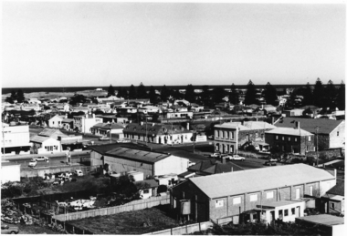
 Lakes Entrance Historical Society
Photograph - New Works
... Black and white photograph showing aerial view of Works... Black and white photograph showing aerial view of Works ...Black and white photograph showing aerial view of Works buildings and cottages near man-made entrance to Gippsland Lakes Victoria boats and boating, topography, settlement, historic buildings -
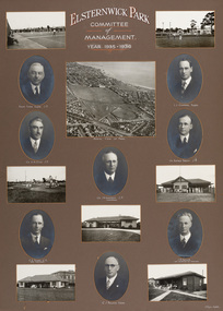 Bayside Gallery - Bayside City Council Art & Heritage Collection
Photograph - gelatin silver photograph, H. Singer, Elsternwick Park Committee of Management 1935-36, 1936
... to Elsternwick Park. One larger rectangular aerial photograph... photographs related to Elsternwick Park. One larger rectangular aerial ...elsternwick park, tennis, football, hockey, playground, sports pavilion, club, ralph tyner, l.l. chapman, cr. g.a. giles, cr. eustace tracey, cr. j.a. kennedy, chairman, cricket, c.e. tuxen, engineer, j.h. taylor, town clerk, treasurer, c.j. pollock, councillor, aerial view, golf, croquet, club house -
Kew Historical Society Inc
Booklet - Old Kew Golf Links Estate, 1926
... of Melbourne. The brochure is notable as it includes photographs of Kew... Chipperfield's Boat House). The aerial photograph, overlaid with names ...Subdivision plans and real estate flyers/brochures reveal a number of aspects of urban development and history. The Kew Historical Society's collection of these plans, as well as advertisements extracted from magazines, cover key aspects of community development and architectural history of Kew and Kew Eat as well as surrounding suburbs. While most of the plans in the collection were gifted to the Society by the former City of Kew, a number of other plans and advertisements have been donated by individuals, of which this is an example.8-page brochure advertising 80 residential home sites for sale in a subdivision called the 'Old Kew Golf Links Estate'. These sites had historic importance in Kew's history as they had previously belonged to Kodak Pty Ltd who were refused permission by Kew Council to use the land for industrial development. The estate, advertised was advertised as being within five miles of Melbourne. The brochure is notable as it includes photographs of Kew East Primary School, the former Kew Golf Club clubhouse, and 'The Moorings' Boathouse (aka Chipperfield's Boat House). The aerial photograph, overlaid with names of notable sites, on the final page is of interest as it shows the area before the intrusion of the Eastern Freeway, which resulted in changing the course of a section of the Yarra River. old kew golf links estate, subdivision -- kew (vic.), subdivisions -- kew east (vic), chipperfield's boathouse, kew east primary school, kew golf club -
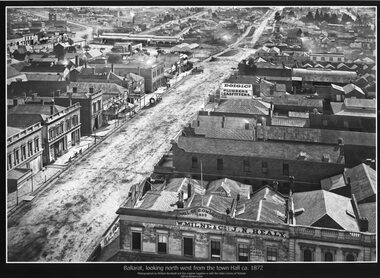 Ballarat Tramway Museum
Photograph - Black & White copy, William Bardell, "Ballarat looking north west from the Town Hall ca 1872"
... Black & White copy photograph aerial view A4 size, titled... copy photograph aerial view A4 size, titled ""Ballarat looking ...Original photograph by William Bardwell, with the original image held by the State Library of Victoria. Edited by Richard Conn. Purchased by the Museum.Provides information about the appearance of Armstrong St from the Town Hall. Shows the topography of the area, along with many buildings, including W Milne & Cp and J N Healy in the Hall of Commerce and Doig & Co, Plumbers and Gasfitters.Black & White copy photograph aerial view A4 size, titled ""Ballarat looking north west from the Town Hall ca 1872" looking along Armstrong St. Original photo by William Bardwell.ballarat, armstrong st, w milne & co, doig&co, j n healy -
Glenelg Shire Council Cultural Collection
Photograph - Photograph - View of Portland and foreshore, 21/03/1972
... Unframed aerial black and white photograph from W...: (no inscriptions) Back: (no inscriptions) Unframed aerial black and white ...Port of Portland Authority archives.Front: (no inscriptions) Back: (no inscriptions)port of portland archives -
Glenelg Shire Council Cultural Collection
Photograph - Photograph - view of Portland and foreshore, 21/03/1972
... Black and white photograph, unframed. Aerial view from west... photograph, unframed. Aerial view from west Portland CBD and Portland ...Port of Portland Authority archives.Front: (no inscriptions) Back: 21/3/1972port of portland archives, aerial view of portland -
 University of Melbourne, Burnley Campus Archives
Photograph - Black and white print, Aerial View of Burnley Campus c.1965, c. 1965
... Black and white photograph. Enlarged photograph of aerial... Black and white photograph. Enlarged photograph of aerial view ...Black and white photograph. Enlarged photograph of aerial view of Burnley College encompassed by the Yarra River and showing the surrounding suburban areas. Mounted on cardboard.aerial view, burnley college, yarra river -
Glen Eira Historical Society
Document - GLEN HUNTLY
... photograph of the Glen Huntly Park Estate and Cypress Plantation.... 3/1 black and white aerial photograph (undated ...This file contains 3 items about land subdivision and development in Glen Huntly: 1/1 colour real estate advertisement (undated) for the auction of lots of land in Glen Huntly Park Estate, Glen Huntly to be held 06/12/1930. The poster includes1 black and white photograph (85mm x 201mm) of the Shopping Centre on Glen Huntly Road and a colour map (95mm x 107mm) of the Estate and surrounding locality. Also included on the poster is 1 black and white photograph of the Glen Huntly Park Estate and Cypress Plantation of the Glen Huntly Park. 2/1 undated advertisement for an auction of land in Glen Huntly Park to be held 19/03/1938 pursuant to an order to an order for sale made by the Supreme Court of Victoria. It includes 1 black and white photograph (52mm x 375mm) of shops along Koornang Road and 1 black and white photograph (52mm x 375mm) of shops along Glen Huntly Road. 3/1 black and white aerial photograph (undated and unattributed) (164mm x 272mm) of Glen Huntly Park Estate and surrounding area, with street names added, which indicates the second section of the Estate for sale.glen huntly, grange road, glen huntly road, watson crescent, garden avenue, wattle avenue, park avenue, mckay avenue, neville street, miller street, morgan street, truganini road, koornang road, glen huntly park and recreation reserve, glen huntly park estate, royal avenue, glen huntly railway station, tram depots, lyons street, moira avenue, katandra road, ormond, mimosa road, glen huntly park pty ltd, city of caulfield, lord h, land sales, auctions, parks and reserves, shops, elsternwick, caulfield -
City of Kingston
Photograph - Colour, 1993
... Laminated aerial colour photograph of Carrum and Patterson...] Yellow circular adhesive sticker Laminated aerial colour ...Carrum is a suburb in the City of Kingston bordered by the Patterson River in the north and Kananook Creek in the south. To the east the suburb is adjacent to Patterson Lakes. The Carrum Station was opened in 1882, when the railway line from Mordialloc was extended to Frankston. In the early 20th century, it was a destination for holidaymakers occupying tents and cabins. The area now consists of older housing and over time there have been many new housing developments.Carrum is located in the area that was originally part of the Carrum Carrum Swamp. The district had originally been the home of the Bunerong people who fished, gathered food and found refuge in the sand dunes. The Swamp was drained in 1879 when the Patterson Cut was formed and became known as Patterson River. Apart from local farmers, fishermen and hotel-keepers, there were few permanent residents until the early 20th century when it had become popular as a beach resort. In the 1920s and 1930s the area became occupied by more permanent residents.Laminated aerial colour photograph of Carrum and Patterson Lakes in the City of Kingston. The photograph also includes Kananook Creek and the northern section of Seaford. Prominent features include Roy Dore Reserve, Carrum Primary School, Patterson River Secondary College, Keast Park Seaford, the Seaford Swamp Drain and a section of Downs Estate situated on the traditional lands of the Bunurong people.Black type on white adhesive sticker: No. 7140 Black type of white adhesive sticker: 31-1-93 Black handwritten ink (marker): * [an asterisk] Yellow circular adhesive stickerpatterson lakes, seaford, carrum carrum swamp -
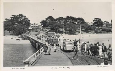 Phillip Island and District Historical Society Inc.
Photograph - Post Cards, A. J. Murray et al, c 1940
... . Black & White aerial photograph of "Broadwater" Guesthouse... in background. Sheds at end. Photograph 228-02. Black & White aerial ...A collection of 6 postcards and 1 photograph taken around Phillip Island. Donated by Julie Barnett.Photograph 228-01. Black & White photograph of the Cowes Pier with vehicles and pedestrians. Rail tracks on pier. Isle of Wight Hotel in background. Sheds at end. Photograph 228-02. Black & White aerial photograph of "Broadwater" Guesthouse, Cowes. Photograph 228-03. Black & White photograph of Cowes Pier with Steamer coming in. Shed at end of Jetty and Cenotaph in the foreground. Looking north. Photograph 228-04. Black & White photograph of a Koala and her young. Photograph 228-05. Black & White photograph looking over the Cowes shoreline near Lover's Walk. Photograph 228-06. Black & White photograph of a group of penguins coming home at dusk at the "Penguin Parade". Photograph 228-07. Black & White photograph of Bert West holding a Shearwater (Mutton Bird) with it's wings outstretched.Photo 01. "Photo Shop Series". "Cowes from the Jetty". Photo 02. Aerial view of "Broadwater" Cowes, Phillip Island. No. 146 Photo 03. "Photo Shop Series". The Jetty. Cowes. Photo 04. "Photo Shop Series". "Koala Bear". Phillip Island Photo 05. "The Rose Series P3416". "Near the Lovers' Walk, Cowes, Phillip Is., Vic. Photo 06. "Penguins, Phillip Island." No. 82. Valentines Series. Photo 07. On Back: Mr West with Mutton bird at Phillip Island.wildlife - koalas, wildlife - penguins, penguin parade, bert west, wildlife - mutton birds, mutton birds, shearwaters, cowes pier phillip island, cowes jetty, lover's walk cowes, broadwater guesthouse cowes phillip island, guesthouses cowes phillip island, julie barnett -
Bendigo Historical Society Inc.
Photograph - Aerial shots of parts of Bendigo 1934, 1934
... This document contains scans of a unique set of aerial photographs... of aerial photographs that were taken over the City of Bendigo ...AERIAL SHOTS OF PARTS OF BENDIGO 1934 Catalogue No.10584 This document contains scans of a unique set of aerial photographs that were taken over the City of Bendigo on Friday 12th January 1934, at about midday. The photographs were commissioned by Bendigo Mines Limited during their exploration and mining program designed to revitalize the Bendigo Goldfield. The photographs were given to the Victorian Mines Department sometime in the 1950s. The photographs were taken at a relatively low level of about 4000 feet. This gives a very detailed picture of Bendigo as it was in the 1930s. The photos cover the City Centre and are mainly of the goldfields on the south side of the city; the extent of which covers approximately the four corners of Myers Flat, Maiden Gully, Mandurang and One Tree Hill. Streets, roads and places of interest have been identified as best as possible in December 2023. There are 44 maps, and each references the adjoining maps.Typed Notes with CD The CD is one of two and contains a set of 46 images: The folder named "High_Resolution_800dpi" contains the original digital files that were produced by scanning the photographic prints (About A3 size) at 800 dpi using a high quality, large pformat, roll scanner. These files may be too large for some computers. A second CD contains a direstory called "Low_Resolution_300dep" The images in the folder names "Low_Reolution_300dpr" have a lower resolution (300 dpi) and have been rotated 90 degrees clockwise so that the Northern margin of each image is a the top of the screen. Clive Willman Senior Geologist Geological Survey of Victoriahistory, bendigo, bendigo mines, bendigo maps, bendigo aerial photos