Showing 3043 items
matching corner houses
-
 Glen Eira Historical Society
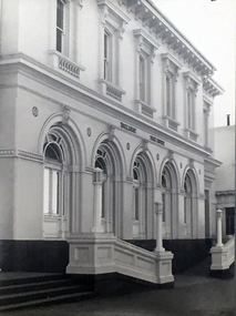
Album - Album page, Booran Road, 30, Circa 1972
This photograph is part of the Caulfield Historical Album 1972. This album was created in approximately 1972 as part of a project by the Caulfield Historical Society to assist in identifying buildings worthy of preservation. The album is related to a Survey the Caulfield Historical Society developed in collaboration with the National Trust of Australia (Victoria) and Caulfield City Council to identify historic buildings within the City of Caulfield that warranted the protection of a National Trust Classification. Principal photographer thought to be Trevor Hart, member of Caulfield Historical Society. Most photographs were taken between 1966-1972 with a small number of photographs being older and from unknown sources. All photographs are black and white except where stated, with 386 photographs over 198 pages. From Glen Eira Heritage Management Plan 1996 by Andrew Ward: In 1888, John Leek, a trainer, owned Lot 15, measuring one and three quarter acres, in Booran Road, north side between Glen Eira and Neerim Roads. The land backed onto the Caulfield Racecourse Reserve. NAV was £45. In 1890 Leek built for his residence, a ten roomed brick house on the site. NAV was £200. Leek was the owner/trainer of "Ingliston" who won the Caulfield Cup in 1900. Upon the horse's death in 1901, Leek is understood to have defied tradition by spending £20 on boots for the "ragged urchins in Bourke Street" instead of "shouting" at the bar. By 1899, the property was owned and occupied by Alfred Merrill, a dentist and was known as "Andover". NA V had decreased to £ll0. By 1910, Leslie Macdonald, a gentleman had purchased the property and renamed it "Moidart". In 1910-11 Macdonald sold it to John Robertson. The property had extensive wood stables on its north-east boundary and several other outbuildings. The house continued to be described as "Brick, ten rooms" as it was in 1926 when it was owned and occupied by John Arthur, a managing director. The land measured la.2r.31p. and had a NAV of £235. Nine people lived there. In 1926, Arthur also owned the adjoining Lot 16. Other racehorses of note, known to have been stabled here include Sobar, Havelock, Proud, Future and Lord.Victorian Heritage Register https://vhd.heritagecouncil.vic.gov.au/places/13532 What is significant? Lord Lodge is a thoroughbred racehorse training complex adjacent to Caulfield Racecourse, established in 1890. The area immediately around the racecourse has been associated with horse racing activities and businesses servicing the industry since the development of the racecourse in late the 19th century. Lord Lodge was named by the present occupants after the champion racehorse Lord who was stabled there in the 1950s. In the early 20th century the property was known as 'Andover' and subsequently 'Moidart'. The site consists of a single storey brick Italianate villa, jockeys' quarters, stables and open day yards with direct access to Caulfield racecourse from the rear of the property. The villa of 10 rooms on bluestone foundations was constructed in 1890 by John Leek, a horse trainer who purchased the newly subdivided land in 1888. The house has many Victorian Italianate or Boom Style features although it is more modest than many villas of its style. It has an asymmetrical facade with a faceted bay window and a prominent central tower with low pitch pyramidal roof that provides a clear view of the racecourse. Other characteristic features include stilted segmented arches, bracketed eaves, stucco wall finish and cast cement ornamentation. A room has been added on the north-facing verandah in sympathetic style and finish. Internally the rooms are substantially intact with original marble fireplaces and intricate ceiling roses and cornices. An entrance toward the rear of the southern side of the house is said to be where the stable hands, jockeys and other staff lined up for their meals. In the southeast corner of the property, backing directly on to Caulfield racecourse, is a substantial late Victorian timber stable, probably constructed in the 1890s but first appearing on the property title in 1910. The stable has 12 stalls, a loft and brick pavement and jerkin head roof form with varnished pine-lined ceiling carried on a chamfered timber frame. It has an original roof lantern. The doors of the stalls are not the original sliding doors but swing doors obtained from a barn at Epsom Racecourse in Mordialloc prior to demolition. Outside the gambrel roof has fretted barges but the building is otherwise utilitarian. Timber throughout the stalls has been worn by chewing and rubbing of horses over the century of its use. In the southern half of the property are open day yards where the racehorses are kept during the day. The red brick, single storey jockeys' quarters to the rear of the villa were probably built around 1950. A small brick, possibly late Victorian structure on the eastern boundary thought to have originally been a gardening shed, has been converted to a stable of two stalls. Modern concrete brick stables fill the northeast portion of the property. At the front of the property two Moreton Bay Figs (Ficus macrophylla), probably planted in the late 19th century, provide shade for horses in the day yards. In the 1890s John Leek sold the property, relocating his training facility to one of the newly established racecourses at Mentone or Mordialloc (Epsom). By 1899, the property was owned and occupied by Alfred Merrill, a dentist, who named the property 'Andover'. In 1910 it was purchased by Leslie McDonald, a gentleman, and renamed 'Moidart'; sold in 1910-1911 to John Robertson; and again in 1926 to John Arthur, a racehorse owner. The Victorian Amateur Turf Club purchased the property in the late 1930s and since this time has been leased to racehorse trainers. It is unclear whether the property operated as a training facility between 1899 - 1926. Several notable trainers and jockeys are associated with Lord Lodge. The best known is Arthur 'Scobie' Breasley, Australia's most successful jockey who was apprenticed to trainer Pat Quinlan at Lord Lodge (then 'Moidart') from 1928 - 1935. Breasley rode winners of the Caulfield Cup in four successive years 1942-45 and again in 1952. John Leek, the original owner of Lord Lodge trained Ingliston, the 1900 Caulfield Cup winner. Along with 'Lord' a number of well known racehorses including Sobar, Havelock, Proud and Future were trained at Lord Lodge .....Page 40 of Photograph Album with three landscape photographs of the exterior of this house.Handwritten: 30 Booran Road [top right hand corner] / 40 [bottom right]trevor hart, jenny o'donnell, booran road, mansion, caulfield east, ingliston, sobar, havelock, proud, future, lord, andover, moidart, lord lodge, grace darling, caulfield racecourse reserve, victorian amateur turf club, historic buildings register, national estate register, caulfield cup, horses, stables, horse racing, racehorses, outbuildings, racehorse trainers, depression, 1890s, brick houses, mansions, towers, verandahs, stained glass, italianate style, victorian style, architectural features, architectural styles, john leek, leslie macdonald, john arthur, john robertson, alfred merrill, jenny odonnell -
 Glen Eira Historical Society
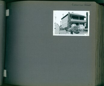
Album - Album page, Carnarvon Road, Circa 1972
This photograph is part of the Caulfield Historical Album 1972. This album was created in approximately 1972 as part of a project by the Caulfield Historical Society to assist in identifying buildings worthy of preservation. The album is related to a Survey the Caulfield Historical Society developed in collaboration with the National Trust of Australia (Victoria) and Caulfield City Council to identify historic buildings within the City of Caulfield that warranted the protection of a National Trust Classification. Principal photographer thought to be Trevor Hart, member of Caulfield Historical Society. Most photographs were taken between 1966-1972 with a small number of photographs being older and from unknown sources. All photographs are black and white except where stated, with 386 photographs over 198 pages. This house is part of HO14 Caulfield North and Environs - Heritage Overlay as a contributing property.Page 42 of Photograph Album with one photograph of a double-storey house on Carnarvon Road.Handwritten: Carnarvon Road [top right hand corner] / 42 [bottom right]trevor hart, caulfield north, carnarvon road, houses, verandahs, balconies, gardens -
 Glen Eira Historical Society
Album - Album page, Clarinda Street, Circa 1972
This photograph is part of the Caulfield Historical Album 1972. This album was created in approximately 1972 as part of a project by the Caulfield Historical Society to assist in identifying buildings worthy of preservation. The album is related to a Survey the Caulfield Historical Society developed in collaboration with the National Trust of Australia (Victoria) and Caulfield City Council to identify historic buildings within the City of Caulfield that warranted the protection of a National Trust Classification. Principal photographer thought to be Trevor Hart, member of Caulfield Historical Society. Most photographs were taken between 1966-1972 with a small number of photographs being older and from unknown sources. All photographs are black and white except where stated, with 386 photographs over 198 pages. Page 44 of Photograph Album with one photograph of a house at 14 Clarinda Street.Handwritten: Clarinda Street [top right hand corner] / 14 Clarinda Street Elsternwick with Caulfield South written in different pen underneath / 44 [bottom right]trevor hart, caulfield south, clarinda street, verandahs, cast iron work, slate roofs -
 Glen Eira Historical Society
Newsletter - CAULFIELD RSL
This file contains one item about the Caulfield RSL’s newsletter: 1/Five issues (nos. 26, 33, 35, 42, and 44) of Furfs, the official newsletter of the Caulfield RSL, dated 12/2000, 05/2004, 10/2005, 12/2007, and 11/2009 respectively. The issues vary in size (numbering 12, 6, 1, 8, and 8 pages, respectively) and consequently, in terms of breadth of content. Most, however, report on the Club’s recent activities, list the current administrative staff, eulogise recently deceased members, and contain advertisements for goods and services of interest to members. All except the shortest also contain numerous black-and-white photographs of members participating in various events. No. 42 also has an article on the progress of the Club history including mention of a 1963 ABC Four Corners episode with footage inside and outside the Club as well as interviews with members.furfs, advertisements, gould tony, moore hedley, frances ken, stewart r. k, whybrow john, mclean tom, elsternwick, canfield bill, anzac day, remembrance day, middlemiss glenys, middlemiss brian, sayers john, rodda alby, st. george’s road, remembrance day service, president’s dinner, annett michael colonel, dejussing clive, stacey carole, white thomas sir, fuller joan, edwards m. t., greer j., warburton jimmy, decker john, mcbean j., mclean s. mrs., gibson ray, rigby jack, oakley trevor, paul’s steak house, wear well dry cleaners, mclean susan, caulfield lions clubs, glen eira district lions, ‘my brother jack’ short story award, ‘glenmore’, everett kevin, lee kenneth c., sneddon bruce n., perignon george j., bradley john m., kennedy colin j., waratah cellars, glenhuntly road, glen huntly road, taverna john, taverna robyn, gaylard bernie, auhl ron, yob loretta, muir frank, morris tony, blaney matt, james bob, kevin brennan, davey kathleen, wreath laying ceremonies, may carl, one petroleum co., ager michelle major, taus joe, geier noel, blore peter, creaney john, wadley geoffrey, oliver mavis i., browne donald d., ross john, kidd william, rea alan m., pollock rob, pollock florence, sell patricia miss, fidler n., dew d., mayell w., booth vincent, booth lois, johnson carl, ‘the ole tin hat’, centre road, bentleigh, rigby pat, eade charles, howell davie, blore jeff, russell paul, kesoglidis kon, morse r. e., long bridford f. r., harkensee keith r., collins williams h., daniels albert e., stephani detleef p. von, walton alan l., canfield william g., barclay henry i., rose frank w., sherriff william g., may donald c., fergus mark l., sorel peter a., chivers keith, scarffe richard a., dalgleish maggie, sampson stan, jacobs frank, ware les, powell massey, merlo harry, perini leo, milnes ‘bluey’, carmody jack, edwards michael terrence, orrock george, lyon stan, raines barbara, raines laurie, hall ron, metherall murray, blore geoff, walker keith, davis max, doyle tom, reece jim, jewell bill, o’neill roe, ferrari ron, fogarty des, sinclair bill, mitchell j., harris l., boughton h. ms., townsend d. mrs., decker j., larkin r., elder g., sell p., clarke john, mclean t., kean phyllis m., booth geoffrey e., donoghue clifton s., durham leonard c., ford john w., nitsche neil h., davidson kelvin r., werba adele, pleydell max, price colin, taberner laurie, condron neil, leech gail, green barry rev’d, veteran’s lunch, devlin joseph h., murray mark blodwen, jackman david d., hall erica d., hackman james f., thompson pauline l., gassick betty m. le, logan george, wilson tony, slater bob, cobby a. h. (harry) air commodore, steinberg alison mrs., astill bob, reed donald, niewland hans, bodelier berry, little harold, hawkes stewart, limbue ram bahadur, kirkwood robert, rai bharansher, mclean susan, mcbean jon, white michael sgt., caspar freddie -
 Federation University Historical Collection
Photograph - Photograph Album, Photographs of Ballarat Buildings, 1967, 1967
When these photos were taken Geoffrey Biddington was highly involved with the Ballarat Branch of the National Trust. At one time Her Majesty's Theatre was known as the Memorial Theatre. Lenaghan of Tourello "Master Dan Lenaghan, eldest son of Mr. and Mrs. R. Lenaghan, of Tourello, has been successful in obtaining a Government scholarship, tenable for four years at St. Patrick's College, Ballarat.(Melbourne Advocate, 02 March 1939) Two Black folders of Ballarat photographs as follows: .1) Interior of Ballarat Railway Station .2) Interior of Ballarat Railway Station .3) Craig's Hotel .4) Craig's Hotel .5) Craig's Hotel .6) Craig's Hotel .7) Ballarat Fine Art Gallery later Art Gallery of Ballarat .8) Cuthberts, corner Lydiard and Mair Streets .9) Golden City Hotel (GCs) .10) Golden City Hotel (GCs) .11) Reid's Coffee Palace .12) Alexandria Tea Rooms, neighbouring Old Colonists' Club, Ballarat, Lydiard Street North .13) ? .14 Caste iron drink fountain, corner of Strurt and Drummond Streets, October 1967 .15) Lal Lal Blast Furnace .16) Ballarat Botanical Garden Gates .17) Ballaarat Old Cemetery Gates .18) Novar gate .19) Ballaarat Old Cemetery Gates .20) ? .21) Webster Street .22) Doveton Street South .23) ? .24) ? .25) .26) .27) Iron hitching Rail .28) Iron hitching Rail .30) Postal Box, Corner or Armstrong Street South and Eyre Street, October 1967 .31) Iron Drinking Fountain in the Ballarat Botanical Gardens .32) Iron Drinking Fountain in the Ballarat Botanical Gardens .33) Killarney, Warrenheip .34) Killarney, Warrenheip .35) Killarney, Warrenheip .36) Killarney, Warrenheip .37) Bailey's Mansion, Drummond Street .38) Bailey's Mansion, Drummond Street .39) Beaufort House .40) Beaufort House .41) ? .42) ? .43) ? .44) ? .45) ? .46) ? .47) ? .48) Lenaghan's Tourello, February 1968 .49) Lenaghan's Tourello, February 1968 .50) ? .51) ? .52) ? .53) ? .54) ? .55) ? .56) ? .57) ? .58) ? .59) ? .70) Her Majesty's Theatre, Lydiard Street .71) Her Majesty's Theatre, Lydiard Street .72) Dana Street Primary School, September 1967 .73) Ballarat School of Mines Administration Building, September 1967 .74) Eureka Street Primary School ? .75) Selkirk Brick Chimney? .76) Grigsby's Foundry, Mair Street, September 1967 .77) Pratt's Warehouse, Camp Street .78) Premises of R. And R.A. Williams, Mair Street, September 1967 .79) City Oval Grandstand, with fire training tower in the background, .80) City Oval Grandstand .81) City Oval Grandstand .82) Smythesdale Post Office, October 1967 .83) Court House Hotel. Smythesdale, October 1967 .84) Smythesdale, October 1967ballarat, buildings, bluestone, iron, architecture, biddington, geoff biddington, railway, old colonists, lal lal blast furnace, beaufort house, her majesty's theatre, craig's hotel, botanical gardens, bailey, cuthbert, lenaghan, tourello, smythesdale post office, court house hotel, smythesdale, smythesdale, alexandria tea rooms, cast iron, eureka street primary school, dana street primary school, ballarat school of mines administration building, grigsby brass founder, foundry, pratt's warehouse, selkirk bricks, grandstand, court house hotel -
Federation University Historical Collection
Booklet - Program, Booklet, Newspaper Cuttings, Map, Quad Sports B.T.C., S.M.B., F.S 1961 and magazine, 4 October 1961
The Diploma Course at the Ballarat School of Mines usually took four years to complete hence the title of the booklet "Your Four Years with Us".Program: Cream card, A4 size, folded in half to make 4 page program. Booklet: 8 cream pages plus cover with image of Ballarat School of Mines on front 7 small newspaper articles Map of SMB in black ink on cream paperProgram: Front: 1961, "Quad" Sports, B.T.C, S.M.B., F.S. printed in black ink. "Michael Whiteside SMB" handwritten on top right hand corner. Inside: Starting time, Event, Records, First, Second, Third, Time or Distance typed with three handwritten names, Michael Whiteside SMB, Philip Lockyer SMB, Judith Christensen BTC and time handwritten 2 Min 8.2 Sec for Men, 880 yards event. Back: Signatures handwritten on back. A KING & Sons Ballarat logo bottom at back Booklet: Michael N Whiteside SMB signature in blue ink on top right hand corner of cover. Inside cover: "This book was stolen from Michael N Whiteside handwritten in blue ink Map has lines drawn from building 3 to 10 to 15 to 14 to 7 with various numbers in circles hand drawn. ballarat teachers' college, school of mines ballarat, ballarat school of mines, quad sports, 1961, philip lockyer, michael whiteside, judith christensen, sports program, program, sports, lake relays, city oval, stewart house, barry house, track events, bob norton, technical schools' regatta, lake wendouree, geelong technical college, gordon institute of technology -
 Federation University Historical Collection
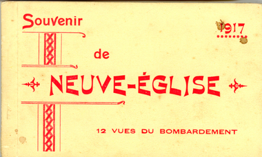
Postcard Booklet, Souvenir de Neuve-Englise - 12 Vues du Bombardement, 1917
Views of places before and after bombardment during World War One.Small cream covered postcard booklet containing 12 postcards. The cover has red printing on the front. Tissue separates each individual postcard. The views shows scenes after the Bombardment of august 1916Front cover: In red print with border down LHS - Souvenir de NEUVE-ENGLISE 12 vues du bombardement "1917" in red print on top right hand corner Verso individual postcards: "Carte Postale" at top Correspondence (LHS top) and Adresse (RHS top) separated by a line in the middle of page LHS bottom corner "Vise Paris 850. Names of scenes on each postcard.postcard, 1917, views, wwi, world war one, first world war, 1st ww, 1916, bombarded church, steenwerck street, ypres, old council house, estaminet de la tete d'argent, "welcome" public house, boarding school for girls, la chapelle, rue de bailleul, bailleul, moulin, windmill, route de dranoutre, mill, brasserie "glorie" au borg, "glorie", brewery, carte postale, postcard, 1917, views, wwi, world war one, first world war, 1st ww, 1916, bombarded church, steenwerck street, ypres, old council house, estaminet de la tete d'argent, "welcome" public house, boarding school for girls, la chapelle, rue de bailleul, bailleul, moulin, windmill, route de dranoutre, mill, brasserie "glorie" au borg, "glorie", brewery, carte postale -
 Federation University Historical Collection
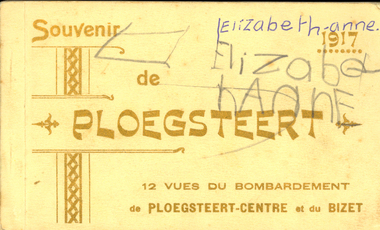
Postcard Booklet, Souvenir de Ploegsteert, 12 vues du bombardement de Ploegsteert-Centre et du Bizet, 1917
Images of places before and after bombardment during World War OneSmall cream covered postcard booklet containing 12 postcards of Ploegsteert with gold printing on front cover.In gold print - Souvenir de PLOEGSTEERT 12 vues du bombardement de PLOEGSTEERT-CENTRE et du BIZET on front cover. "1917" on right hand side front cover in gold print. "Elizabeth-anne in blue biro and pencil on RHS top corner" handwrittenworld war one, wwi, 1st ww, 1917, ploegsteert, postcards, souvenir, bizet, bombardment, 1915, church, 1916, soldiers, post office, the armentieres, armentieres, therry, burgomaster, doctor, rectory, "marshal" public house, bombarded church, le bizet, convent, girls school, school, world war, flanders, world war one, wwi, 1st ww, 1917, ploegsteert, postcards, souvenir, bizet, bombardment, 1915, church, 1916, soldiers, post office, the armentieres, armentieres, therry, burgomaster, doctor, rectory, "marshal" public house, bombarded church, le bizet, convent, girls school, school, world war, flanders -
 Federation University Historical Collection
Photograph, Ballarat photographs by Geoff Biddington, 1967, 1967
.6) Australian Catholic University Ballarat Campus (Aquinas) is set in the historic gardens of Carn Brea, formerly the property of Cornish miner Cyrus Retallack. The property includes a two-storey mansion, which he built as his family home in 1881. Carn Brea, a castle in Cornwall, was built in the 1500s. After the Queen's Church of England Girls' Grammar School acquired the property in 1919, the mansion was renamed Manifold House. Manifold House now accommodates administrative facilities of the campus and staff offices. (http://www.acu.edu.au/about_acu/campuses/ballarat/history_of_ballarat_campus, accesses 21 August 2014)Nine black and white images by Geoff Biddington. .1) Burke and Wills Monument, corner Sturt Street and Lydiard Street, with the MLS Building and Allan Brothers in the background. .2) Former Ballarat Post Office (later Federation University Post Office Gallery) .3) Tram in Sturt Street .4) Geelong ? shopping centre .5) Geelong Waterworks and Sewerage Trust .6) Carn Brae / Retallacks / Queen's / Australian Catholic University, 1200 Mair Street .7) Former Ballarat Post OFfice, Lydiard Street .8) Perseus Statue, Camp Street (removed for conservation in 2008) .9 McDonald Printer, 48 Lydiard Stgeoff biddington, ballarat, ballarat post office, geelong waterworks, perseus, mcdonald, acu, carn brae, australian catholic university ballarat, burk and wills monument, mlc building ballarat, allan brothers ballarat, lydiard street, sturt street -
 Federation University Historical Collection
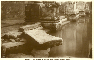
Postcard - Sepia, The Diving Stone in the Great Roman Bath, Bath, Somerset
The Great Bath is a massive pool, lined with 45 sheets of lead, and filled with hot spa water. It once stood in an enormous barrel-vaulted hall that rose to a height of 40 metres. For many Roman visitors this may have been the largest building they had ever entered in their life. The bath is 1.6 metres deep, which was ideal for bathing, and it has steps leading down on all sides. Niches around the baths would have held benches for bathers and possibly small tables for drinks or snacks. A large flat slab of stone is set across the point where hot water flows into the bath. It is known today as the diving stone. The Roman Baths complex is a site of historical interest in the English city of Bath. The house is a well-preserved Roman site for public bathing. The Roman Baths themselves are below the modern street level. There are four main features: the Sacred Spring, the Roman Temple, the Roman Bath House and the Museum, holding finds from Roman Bath. The buildings above street level date from the 19th century. Sepia postcard of a section of the Great Roman Bath at Bath, Somerset featuring the Diving Stone.printed verso: The Diving Stone in the great roman bath. The Diving stone, at the north-west corner of the great Roman Bath, still shows where the feet of bygone bathers wore away its surface. The hot mineral waters flowed into the bath through a channel under this stone. chatham-holmes family collection, bath, great roman bath, swimming pool -
 Federation University Historical Collection
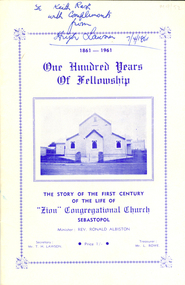
Booklet, Alex. King & sons, Printer, The Story of the First Century of the Life of "Zion" Congregational Church, Sebastopol, 1961, 1961
The former "Zion" Congregational Church was on the corner of Walker Street and Beverin Street in Sebastopol. Its origins began as 'Zion" Welsh Independent Church in Albert Street, Sebastopol. The Uniting Church in Australia was inaugurated in June 1977, at which time the Sebastopol Methodist Church joined with the Zion Congregational Church on Walker Street, Sebastopol and became Sebastopol Uniting Church. The block to the south of the church was purchased in 1982, the occupying house demolished and the area cleared and later sealed for parking. In 1984 the interior of the church was renovated and plans were drawn up for further additions and alterations to the Sunday school, which were carried out in 1989, adding a kitchen and toilet built by Jeff Menhennett & SonsWhite soft covered booklet of 20 pages with blue printing. Written in biro on front cover "To Keith Rash with compliments from Hugh Lawson 7/4/1961"zion congregational church, sebastopol, carmel welsh church, zion hall, hugh lawson, sebastopol unitng church -
 Federation University Historical Collection
Work on paper - Artwork, Ballarat East Main Road Joss House Rubbings
A number of rubbings of calligraphic carvings thought to be from the Ballarat East Joss House in Main Road. .1) Blue and brown crayon. Translation: Erected on an auspicious day in winter 1859. Think of his loyalty (Quan Yu, now can canonised as the god of war to whom this temple is dedicated) (AD1084) to his sworn lover their sworn botherhood pledged in the peach garden as has been praised for thousands of years. .2) Rubbing in blue crayon of Chinese calligraphy from pole on right hand side of Joss House Door. (Larger) his great graciousness spreads to other (us here in foreign lands) kingdoms, and his virtue guards our gold miners everywhere. (Smaller) Dedicated to his disciples the Chu Pei-Huo family .3) Rubbing on litho paper. translation - One who knows the nature of things (in the world) will thus understand human nature. .4) Rubbing on litho paper. Translation of middle calligraphy - We all behold the wisdom of the gods in the heavens, earth and man. .5) Rubbing on litho paper - translation - The grace of god flows to all corners of the earth. .6) Charcoal rubbing - translation - Temple of the god of war. .7) Crayon rubbing of calligraphy on litho paper. Translation - Dedicated by the Ma Chu-Feng family. Emperor's virtue spreads far and wide. Grace in Abundance. Erected in winter, 1859. .8) Crayon rubbing of calligraphy on litho paper. Translation: Respectfully dedicated by the Ts'Ai Chi-Yang family. Grace in abundance. Erected in winter of 1859. .9) Crayon rubbing .10) Outline of calligraphy on copy paper .11) Rubbings of calligraphy on copy paper. Translation: The Holy God of War. Exhibited in 1862. Your respectful disciples. .12) List of 11 disciples chinese, joss house, keith rash, chu pei-huo, quan yu, ma chu-feng, ts'ai chi-yang, lee chua-yeh, hwong tien-jyue, wa perg-nan, liu chin-chuson, an lee factory, lice hsue-chiere, lee mei-tzy, lee pas-chi, lui lih-nie, wir hon-fu, li hsi-yang -
 Federation University Historical Collection
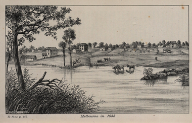
Image, John Helder Wedge, Melbourne in 1838, 1938
... House — on the corner of William and Flinders Streets — stands... to where the Immigration Museum at the Old Customs House ...The following information is from http://melbourneday.com.au/about.html, accessed 30 August 2016 Melbourne was founded on 30 August 1835 by settlers who sailed from Van Diemen’s Land (Tasmania) aboard the schooner Enterprize. They landed on the north bank of the Yarra River and established the first permanent settlement, close to where the Immigration Museum at the Old Customs House — on the corner of William and Flinders Streets — stands and the place today known as Enterprize Park. Melbourne Day Committee was established to help correct the record about the founding of Melbourne and celebrate its anniversaries. The settlers came from Launceston in search of sheep-grazing land. Land had become expensive and there had long been stories told by whalers and sealers working in Bass Strait of fertile land to the north. This was the southern part of the colony of New South Wales, which the Colonial Government did not want settled at that time. After the Henty family crossed Bass Strait and settled at Portland in 1834 others quickly followed. The north bank was chosen because a small waterfall, or rapids, stopped further progress up the river. The waterfall also separated the tidal movement, providing a vital supply of fresh water. The site had previously been noted by the colony of New South Wales' surveyor, Charles Grimes, in 1803. The north bank also offered more stable, suitable ground. The people of the Kulin nation are the traditional owners of the land that became Melbourne — including the Boonwurrung, Woiwurrung, Taungurung and Djadjawurrung people, who gathered in this place for ceremonies and cultural activities. The topsail schooner Enterprize you see today is a full-size replica of the one that brought the settlers and has become a symbol of Melbourne Day. Her keel was laid at Polly Woodside Maritime Museum in 1991, and the $2.5 million, 27m vessel was launched by Felicity Kennett on 30 August, 1997, at Hobsons Bay. The original ship was bought by John Pascoe Fawkner in April 1835 specifically to search for a suitable place for a settlement in the Port Phillip District. After helping establish Melbourne, the original Enterprize continued operating as a coastal trading vessel for a number of years. She eventually disappeared off the shipping register in 1847, having been wrecked on a sand bar in the Richmond River in northern NSW, with the loss of two lives. The replica is managed by the Enterprize Ship Trust, a not-for-profit organisation. The first settlers were those on board the Enterprize — her crew and passengers. They were John Lancey , master mariner and Fawkner’s representative; Enterprize's captain, Peter Hunter; George Evans, plasterer/builder; carpenters William Jackson and Robert Hay Marr; Evan Evans, George Evans’ servant; and Fawkner’s servants ploughman Charles Wise, general servant Thomas Morgan, blacksmith James Gilbert and his pregnant wife, Mary. And Mary's cat! Enterprize set sail on her historic voyage from Launceston on July 21, 1835, stopping at George Town in northern Tasmania where creditors detained Fawkner. He was therefore not part of the first trip to Melbourne. Enterprize then left on August 1 under the command of captain Hunter. The expedition was led by Lancey, Fawkner's delegate. The party first considered Western Port and the eastern side of Port Phillip for a place to settle, before deciding on the Yarra’s north bank — known today as Enterprize Park. On Sunday, August 30, they disembarked and began to erect shelter, build a store and clear land to grow food, thus starting the permanent European settlement of Melbourne.Image of the fledgling town of Melbourne on the banks of the Yarra River. melbourne, yarra river, john helder wedge -
Federation University Historical Collection
Photograph - Black and White, Former Ballarat Library, c1960
First known development on this site was the establishment of the Government Camp from the early 1850s. It was established to accommodate officials, troopers and police who were needed to administer the goldfields. Some permanent buildings were constructed. Lack of materials and bad weather prolonged the building of more permanent buildings and most men were still living in tents. Area was known as Camp Reserve. In 1864 a subdivision map shows the reserve be used for Public Buildings. Library applied for land on corner of Sturt and Camp Streets in 1878. 1880s plans show section of the reserve be used for a Free Library and Reading Room. Lease was granted and the old mining boardroom was initially used. Land for additional building to house a Museum and Art Gallery sought and agreement reached in 1882-3. Compensation paid to owners and library granted the land. Plans for a new library building with tower and lantern roof abandoned due to lack of funds. It wasn't until 1895 that a solution to funding was found and the library was able to begin constructing the complex of buildings on the Free Library Reserve. A number of changes have occurred since 1910s - the Classical Revival facade replaced with an angled facade in a stripped Classical style with Art Deco features and high parapet. Building is now part of Federation UniversityPhotograph of former library. Shows a two-storey rendered brick building in a Classical style. Some Art Deco features. Central pair of double windows with single window either side. High parapet above.government camp, goldfields, camp reserve, free library, reading room, sturt street, camp street, museum, art gallery, troopers, police, barracks, camp street -
 Federation University Historical Collection
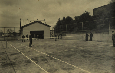
Photograph - Photograph - Black and White, Richards & Co, Ballarat Junior Technical School Tennis Court - 1956, 1956
When Ballarat Junior Technical School building was opened in 1921, there was little cleared space for the students to use for sporting activities. The area known as Battery Paddock was used for dodge-ball and football. Gradually the slope area was cleared and planted. In November 1922 a tennis court was opened in the Battery Paddock. It was designed and built by two former students of the Ballarat School of Mines. The old Mount Doran school house was moved to the area as a students' common room. A new tennis court was built in the same vicinity in 1934. This area was on the corner of Grant and Albert Streets. Area is where the Corbould Building and the Automotive Skills Centre of School of Mines Ballarat Grant Street Campus now stand. Black and white photograph of the tennis court built in 1934 at Ballarat Junior Technical School. Gaol wall to the left and the old Mount Doran school house that was moved to the school grounds in 1922 and used as a Students' common room. Four students playing tennis with others watching.Stamp on back indicating photographer - "Richards & Co - Ballarat"ballarat junior technical school, student, 1921, battery paddock, ballarat school of mines, ballarat school of mines tennis court, mount doran, students' common room, 1934, grant street, albert street, corbould building, automotive skills centre, student activities -
 Federation University Historical Collection
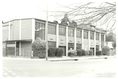
Photograph, Ballarat School of Mines Corbould Building, 1986, 1996
The Corbould Building is located on the corner of Grant Street and Albert Street, Ballarat.Black and white photography of a double storey brick building known as the Ballarat School of Mines Corbould Building. It houses automotive studies. ballarat school of mines, corbould, corbould building, automotive, corbould recreation hall -
 Federation University Historical Collection
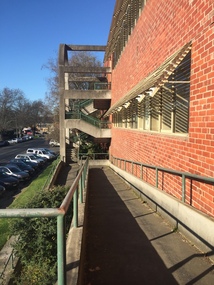
Photograph - black and white, Clare Gervasoni, Ballarat School of Mines M.B. John Buildings, 2016, 08/09/2016
The M.B. John Building (Building K), a three storey, face red brick, restrained Late Twentieth Century International styled building with an elongated, cuboid form (defined by the parapeted facades) that is offset by projecting exposed concrete framed, round‐arched entrance and stair wells on the east (Albert Street) elevation (the centrally located entrance breaking the brick façade with glazing). The facades are also characterised by banks of aluminium framed, horizontal ribbon windows, which wrap around the building corners. Metal shades project beyond the windows, while post‐supported bullnosed verandahs and hoods and projecting concrete stairs are other features. On the west elevation, the cuboid façade is punctuated by projecting curved concrete and glazed, elongated bays at first floor level. (David Rowe/Wendy Jacobs)Colour photograph of a red brick building on Albert Street. It was build to house trade workshops and Ceramics at the Ballarat School of Mines. m.b. john, m.b. john building, ballarat school of mines -
 Flagstaff Hill Maritime Museum and Village
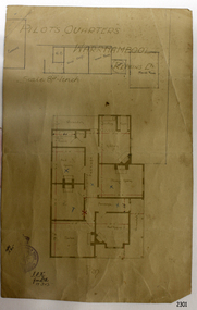
Document - Plan, Pilots Quarters Warrnambool
Warrnambool was officially made a Port of Entry in 1855 and by the 1870s had became the dominant port in the Western District. Sadly, due to an increasing problem with silting in the harbour, by the 1890s only small vessels could navigate the harbour. Men with the position of Pilot and Harbourmaster in Warrnambool were employed by the government to enforce government regulations and to help guide vessels safely into the port of Lady Bay, which was difficult to navigate. Some of the Pilots and Harbour Masters of Warrnambool were – - Captain Christopher Gwatkin, the first Harbourmaster for Warrnambool (1857 - his death in 1859). - Captain Helpman was Warrnambool’s second Harbourmaster 1859-1869 - James Nicol was Harbourmaster in Warrnambool for a time, including 1906 (b. 1840 – d. 1926) - Thomas Smith Drewett (1853 - 15-3-1905) past Captain of the Helen Nicoll, Pilot and Harbourmaster of Warrnambool. Warrnambool’s Tourist Guide of 1888 advises that “At the Port of Warrnambool there are two Leading Lighthouses. A licensed sea pilot, Captain Drewett, is stationed at the Port.” In 1915 plans for the Pilot’s Quarters were drawn up for the Department of Public Work. It was at that time, when personnel was short due to the First World War, that apparently the Pilot and Harbourmaster was also responsible for maintaining the light (lighthouse). The new Pilot and Harbourmaster’s house would be built on the site at 88 Merri Street, overlooking Lady Bay and right beside the Flagstaff and the Lady Bay Upper Lighthouse. Other Pilot and Harbourmasters were - - James Menzies was the Pilot and Harbourmaster at Warrnambool in 1929 . In 1932, he was appointed to the position of Acting Secretary to the Warrnambool Harbour Board. A hundred or so years later Flagstaff Hill Maritime Village has fully renovated the former Harbourmaster’s quarters, changed the name to Lighthouse Lodge, and is now allowing guests to stay in the home, which is still neighbour to the operational Lady Bay Lighthouses, now over 150 years old. The association of the old Pilot and Harbourmaster’s Quarters (currently renamed as Lighthouse Lodge) with the Port of Warrnambool, and its maritime activities, is historically significant. The Pilot’s quarters are connected to a time when access to Warrnambool’s Port was important to the colonial settlers for income and supplies. Plan of Pilots Quarters, Warrnambool. Printed and handwritten plan shows house, garage, out buildings and maid's room. The plan's lower left corner has an official stamp and text beside the stamp. Department of Public Works, Melbourne, Victoria, March 11th, 1915. "PILOTS QUARTERS WARRNAMBOOL" "Department of Public works, Melbourne, Victoria I.P.K. , 11.3.15"flagstaff hill, warrnambool, shipwrecked-coast, flagstaff-hill, flagstaff-hill-maritime-museum, maritime-museum, shipwreck-coast, flagstaff-hill-maritime-village, plan, pilot's quarters warrnambool, pilot and harbourmaster's quarters warrnambool, pilot and harbour master's quarters warrnambool, port of warrnambool, department of public works victoria, lady bay lighthouses, warrnambool ports and harbours -
 Flagstaff Hill Maritime Museum and Village
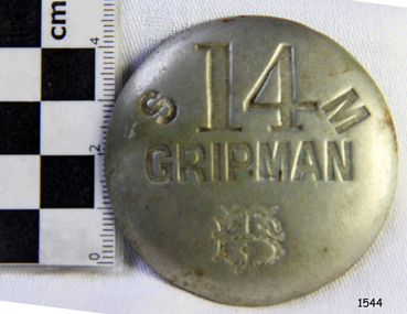
Badge - Gripman Badge, Stokes & Sons, Jul 1916 - Nov. 1919
This cable tram Gripman’s badge, or driver’s badge, was part of a tram driver’s uniform. The inscriptions on the front of the badge identify it as belonging to Gripman number 14, at the South Melbourne Car House depot of the Tramways Board. The Gripman Badge would be re-issued whenever another Gripman takes over the position. Cable trams were invented in America in 1873. In Melbourne, cable trams were in use from 1885 until 1940, with a network of up to 1200 cable cars or 'dummies' and trailers travelling at around 9.5 miles (15km) per hour along 46 miles (74km) of double tracks. The Gripman drove the dummy car, operating the heavy levers to connect the gripping gears to the cable installed in a slot in the road. To turn at intersections he would skilfully disconnect, freewheel around the corner and carefully reconnect to the continuously operating steel cable. Large winding gears in an Engine House along the line pulled the cable along, powered by steam engines and later electric engines. The gripping gears were in the centre of the car's floor with seating all around the sides, a dangerous place for curious children. , whose worried parents would guide them into the tram that was towed behind the dummy car. The Melbourne Tramways Board operated the cable trams between July 1916 and November 1919 after taking over from the privately operated Melbourne Tramway and Omnibus Company. In 1919, the Melbourne and Metropolitan Tramways Board (MMTB) took over the Tramways Board. Stokes & Sons: - The maker of the badge, Thomas Stokes, migrated to Melbourne from Birmingham in 1854 and set up business in Mincer Lane as a die-sinker, producing medals, tokens, buttons and silverware, and an engraving service. He moved to Flinders Lane in 1856. After a time, in 1894, the business became Stokes & Sons Pty: Ltd, electroplates and badge makers at Post Office Place in Melbourne. The maker's mark 'Stokes & Sons' was made on badges until 1962. LOCAL CONNECTION: -t was common practice to recycle the used cables from the tramway. For example, the Wollaston Bridge in Warrnambool, Victoria, is suspended by recycled cable tram Melbourne. (Other recycled cables were used for fencing wire.) -Portland's cable tram is an example of the cable trams used in Melbourne from 1885 to 1940.This badge was used to identify a Gripman who operated a cable car tram's dummy car for the Tramways Board in Melbourne between 1916 and 1919. It represents the need for people to be able to identify workers in the service industry, a need still addressed today by staff ID badges and digital identification. The badge also represents the period in Melbourne's history when cable cars were used for public transport for over four decades, gradually changing from steam to electric power. Trams still have an important role in Melbourne's public transport. Badge, round hollow metal dome with two open metal guides on the back. A cable tram Gripman (driver) badge with embossed inscriptions on the front and stamped on the back. There is a logo of entwined letters T and B on the front. It identifies Gripman number 14, South Melbourne, Tramway Board. It was made by Stokes & Sons of Melbourne. Impressed into the front: "S / 14 / M" "GRIPMAN" Logo intertwined "T" and "B" Embossed on reverse "STOKES &o SONS"flagstaff hill, flagstaff hill maritime museum and village, warrnambool, maritime museum, maritime village, great ocean road, shipwreck coast, badge, gripman, stokes & sons, numesmatics, tramway, tram, tram driver, uniform, cable tram, identification, cable car driver, tramway board, south melbourne, melbourne tramways board, tb, mtb, mmtb, melbourne and metropolitan tramways board, tramway button, gripman button, id, identification badg, staff badge, name badge, employee, grip car, dummy car -
 Yarra Glen & District Historical Society
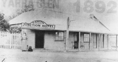
Black and white photographs, Junction Hotel, Yarra Glen
The Junction Hotel was built before 1875. It was located on the corner of the Yarra Glen-Eltham and Steels Creek Roads opposite the cemetery. The building was burnt down in August 1935. Samuel Smith was the licensee from 1895 until 1905Black and white photograph of the Junction Hotel, Yarra Glen copied from newspaper. The words "YARRA GLEN 1892" appear above the building. Sign on building "S.SMITH JUNCTION HOTEL LICENSED VICTUALLER". A woman wearing an ankle-length dress and boots is standing near main entrance. Weatherboard and iron roof, picket fence. Two bentwood chairs on brick-floored verandah. A light pole is attached to the verandah post. picket fence, nineteenth century, 19th century, hotel, bentwood chair, public house, sam smith, samuel smith, weatherboard, iron roof, tin roof, woman, junction hotel -
 Yarra Glen & District Historical Society
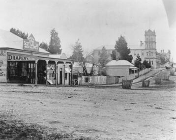
Black and white photographs, Bell Street Yarra Glen
Photograph taken from the corner of King Street and Bell Streets Yarra Glen with a view of buildings on the western side of Bell Street from Scott & Allen's General Store to the Colonial Bank building. Other buildings include the house of Charles Bath and the Grand Hotel. Tree guards line the street.grand hotel, bell street, tree guards, charles bath, general store, scott allen s general store, colonial bank, bank building, hotels -
Federation University Historical Collection
Handbook, The School Paper Grades V and VI Victoria Education Department, 1964-1966
Three handbooks with green patterns on recto and verso. Linen tape is on the spine. Paper is bound by string, connected at the top and bottom. .1)This handbook is a collection of The School Paper for grades V and VI, by the Victorian Education Department for 1964. It's contents are including by not limited to poetry and short stories submitted to the paper from a variety of authors such as "Beside the Road" by Louis H. Clark, information regarding the events of the time such as Air Force Commemoration Week, writings such as piece regarding self-control while using alcohol. and sheet music for various songs, such as "God save the queen". A history of Port Melbourne is included on page 2. A history of Australia's cattle trade is included on pages 11-12. In addition, A biography of Sid Kidman, Australia's "cattle king" is included between pages 36-37. .2)This handbook is a collection of The School Paper for grades V and VI, by the Victorian Education Department for 1965. It's contents are including by not limited to poetry and short stories submitted to the paper from a variety of authors, such as "Pit-Pony" by S.A. Bainbridge, information regarding the events of the time such as the Fig Harvest at El-Flaye, and sheet music for various songs, such as "Old John Braddleum". The short story "The ANZACS at Gallipoli" includes a photograph of James Simpson Kirkpatrick with his donkey, bearing a wounded soldier (Page 33). A piece titled "A good-bye and a welcome" on pages 50-51 details the farewell to Alex McDonell, the director of Education for Victoria from 1960 to 1965, and the welcoming of Frederick H. Brooks as the new Director of Education in Victoria. A supplement is included in regards to "Scholarships and Allowances available for further education" for July 1965. A biography of Rudyard Kipling is on pages 103-105. A monthly series titled "The Seed from which they grew" detailed the history of some of Victoria's historical institutions: Victoria's Government House, The Royal Botanic Gardens, Victorian Railways, School Broadcasts, (Victorian) Public Libraries, The Forests Commission of Victoria, The Correspondence School, The Royal Mint, Her Majesty's Mail, Victoria Police, and Fire brigades. .3)This handbook is a collection of The School Paper for grades V and VI, by the Victorian Education Department for 1966. It's contents are including by not limited to poetry and short stories submitted to the paper from a variety of authors such as "The Emu" by Joan Wise, information regarding the events of the time such as Australian Literature Week, and sheet music for various songs, such as "Potatoes"'. "The Nation Builders" was a monthy series serialised in the paper about explorers who helped to found Australia, such as Matthew Flinders, Baron Sir Ferdinand Von Mueller, Patrick ("Paddy") Hannan, Charles Yelverton O'Connor, John Ridley, Thomas Sutcliffe Mort, Sir Sidney Kidman, Hugh Victor McKay,Robert Hoddle, and Charles Kingsford Smith. A supplement is included in regards to "Scholarships and Allowances available for further education" for July 1966..1) , "Grade 5 Classroom Copy" and "1964" recto. Pages 17, 32, 81, 97,113, 129 features the text "A.J. Mathieson".Page 49 has the text "Grades 5/6 Staff Copy A.J. Mathieson". Page 17 has tick marks on lower right hand corner. Registration number written on verso bounding as "11735.1" in pencil. .2)"Grade 5 Classroom Copy" and "1965" recto.Registration number written on verso bounding as "11735.2" in pencil. .3)"Classroom Copy", "1966", "5" and a black curved line in the middle of the page recto. Page 1 has "A.J. Mathieson" on the top right hand side in red marker. In the middle of Page 35, there is some text underlined, and the comment "Quote Governor King" in green ink.Registration number written on verso bounding as "11735.3" in pencil.1964, handbook, alex ball, victorian education department, school paper, grade v and vi, hymns, poetry, songs, short story, charles kingsford smith, 1965, 1966, matthew flinders, baron sir ferdinand von mueller, patrick hannan, paddy hannan, charles yelverton o'connor, john ridley, thomas sutcliffe mort, sir sidney kidman, hugh victor mckay, robert hoddle, james simpson kirkpatrick, alex mcdonell, frederick h. brooks, rudyard kipling, victorian government house,, royal botanic gardens, victorian railways, school broadcasts,, victorian public libraries, forests commission of victoria, correspondence school, royal mint, her majesty's mail, victoria police, fire brigades, port melbourne, sid kidman, cattle king, cattle trade -
 Flagstaff Hill Maritime Museum and Village
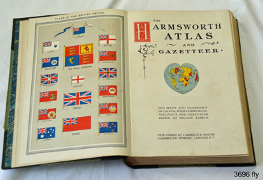
Book, Harmsworth Atlas and Gazetteer, 1908
This Harmsworth Atlas and Gazetteer was inherited by one of the donors, a gift from her father who was Tasmanian.Large hard covered book with maps, charts and tables. The cover is green linen with green leather, gilt trimmed corners and decorative spine, It includes 500 maps and diagrams in colour, with commercial statistics and gazetteer index of 105,000 names. Jan 1908. Also inserted between the pages of the book were 2 folded sheets of waxed paper, each with carefully placed flowers pressed between them; native orchids and wattle. Published at Carmelite House, Carmelite Road, London flagstaff hill, warrnambool, shipwrecked coast, flagstaff hill maritime museum, maritime museum, shipwreck coast, flagstaff hill maritime village, great ocean road, harmsworth atlas and gazetteer, atlas 1908, maps 1908, gazetteer 1908, book 1908, pressed australian native flowers, pressed wattle, pressed orchid -
 Federation University Historical Collection
Photograph - Black and White, Chatham-Holmes Collection: House (location unknown)
... Unknown house on the corner of an intersection. Location... house on the corner of an intersection. Location appears ...Unknown house on the corner of an intersection. Location appears to be in a built-up or city area.chatham-holmes collection, house -
Glenelg Shire Council Cultural Collection
Photograph, n.d
Port of Portland Authority ArchivesBack: top left - PHT - Black Pen fd004 - pencil "Present-day view of the Port of Portland from the "London" corner provides a vivid contrast to a picture taken almost a century ago (P.H.T. l-)" typed on paper, stuck to back of photo.port of portland -
Glenelg Shire Council Cultural Collection
Administrative record - Ledger, General Ledger Transfer No.2, 1914-1947
Donated by abattoir staff during cleanup prior to demolition in 1996. Company at that time owned by Australian Meat Holdings.borthwicks, thomas borthwick and sons, abattoir, portland, accounts -
Glenelg Shire Council Cultural Collection
Photograph - Photograph - front view of "Al-Qurain" live sheep transport ship, n.d
Port of Portland Authority archives. The Al Qurain is a livestock carrier registered under the flag of Kuwait. On the afternoon of Thursday 28 July 1988, while berthing in Portland harbour, Victoria, the Kuwait-registered livestock carrier Al Qurain struck a wharf knuckle heavily and ruptured a ship's side fuel tank. An estimated 184 tonnes of bunker C fuel escaped into the harbour. The port authority boomed off the entrance using oil spill boom. Fortunately the wind also helped to keep the oil in the south-east corner of the harbour.Front: (no inscriptions) Back: (no inscriptions)port of portland archives, al-qurain, live sheep transport, livestock, livestock carrier -
Glenelg Shire Council Cultural Collection
Photograph - Photograph - Silo Construction, n.d
Port of Portland Authority Archives.Back: June 26th (Top left corner, pencil)port of portland archives, portland harbour, silo construction -
Glenelg Shire Council Cultural Collection
Book (Collection) - Portland Lighthouse Circulars - Volume I, 1892-1913
port of portland archivesport of portland archives -
Glenelg Shire Council Cultural Collection
Administrative record - Ledger - chemist account book, January 1922 - March 1934, 1922-1934
Local ChemistFront: n/achemist, accounts, ledger