Showing 1088 items matching "falls creek"
-
 Federation University Historical Collection
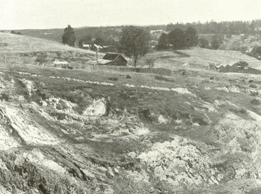
Photograph - Booklet with plans and sections, H.S. Whitelaw, The Daylesford Goldfield, 1923, 1923
... stony creek falls... daylesford hepburn springs cornish mine stony creek falls jim crow ...The Daylesford goldfield was originally known as Jim Crow. Salmon pink soft covered book with a number of plates showing images relating to the Dayelsford goldfieldcornish, mining, daylesford, hepburn springs, cornish mine, stony creek falls, jim crow, wombat -
 Kiewa Valley Historical Society
Leaflet - Kiewa, Welcome to Kiewa
... a popular tourist destination with Falls Creek Ski field within its... destination with Falls Creek Ski field within its boundaries ...The State Electricity Commission of Victoria constructed the Kiewa Hydro Electric Scheme from 1938 to 1961. The Scheme included three power stations, dams, tunnels and was becoming a popular tourist destination with Falls Creek Ski field within its boundaries.This leaflet was published by the SECV to ensure all visitors to the Kiewa Hydro Electric Scheme were made aware of safety measures with regard to their driving and to bush fires. These were necessary as the area was unique with driving on mountainous roads, changeable and extreme weather and the threat of bush fires. The gatehouse existed during construction, when the SECV was in charge, as a restriction to entry to the Scheme for SECV workers and those with permission to enter. The SECV controlled the area so in case of accident, the SECV was the body to contact not eg. the police.Small white and green leaflet made from one sheet of glossy paper and folded in half. Front cover has the title in the middle, the SECV emblem at the centre top and across the bottom is a message to read the inside pages which are safety messages for driving and bush fires. The back cover has a RACV road map of Kiewa and its 'works' including the Gatehouse which was the entrance to the scheme.The map also has an insert of the main roads & nearby cities. state electricity commission of victoria; kiewa hydro electric scheme; gatehouse; safety rules; kiewa -
 Falls Creek Historical Society
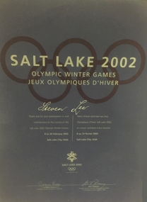
Certificate - Steve Lee participation at Salt Lake Winter Olympics 2002
... Steve Lee grew up in Falls Creek and had skis on his feet...Falls Creek Historical Society Slalom Street Falls Creek ...Steve Lee grew up in Falls Creek and had skis on his feet when he was just two years old. He later became a member of the Falls Creek Race Club and at the age of 14 won State and National Junior titles. After repeated success, Steve was selected to race overseas in the Australian Junior team. He won the Australian Open Championship at the age of 17. For 10 years, Steve never missed a race in the World Cup Circuit. Overall, he claimed 20 top 15 finishes in Downhill, Super-G and combined events. Towards the end of his career Lee swapped the World Cup circuit for the World Pro Tour in the USA, winning the Pro Downhill Tour ‘King of the Mountain’ title. He was also running a photography business in Falls Creek and was also involved in sports commentating on Australian television. This included commentating Alpine Freestyle events at four Winter Olympics and several World Championships. One of these events was the Winter Olympics at Salt Lake City in 2002 for which this certificate was awarded.A certificate featuring the Olympic Rings and text on a dark blue background.SALT LAKE 2002 OLYMPIC WINTER GAMES JEUX OLYMPIQUES D'HIVER Steven Lee Thank you for your participation in and contributions to the success of the Salt Lake 2002 Olympic Winter Games 8 to 24 February 2002 Salt Lake City, Utahsteve lee, australian olympians, sport commentator -
 Falls Creek Historical Society
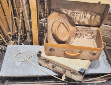
Memorabilia - VIntage Sledge and suitcase
... stakeholder in Falls Creek, first building and owning Koki Lodge...Falls Creek Historical Society Slalom Street Falls Creek ...These items were donated by George Shirling, a long-term stakeholder in Falls Creek, first building and owning Koki Lodge and later owning and operating the Red Onion Lodge. The metal sledge was at Red Onion when George bought the lodge from Lauriston GIrls' School in 1974. Lauriston had owned the Red Onion for about three years. The sledge was most likely made or acquired by the Australian Alpine Club who had built there in 1963 and owned the Lodge until 1970. The suitcases belonged to George Shirling's parents who arrived in Australia from Austria in 1938. George then used this suitcase when he travelled to Falls Creek in the early 1960s.These items are significant because they were donated to the Falls Creek Historical Society by a long-standing and highly regarded member of the Falls Creek community.A sledge made from a metal frame and base plate with a rope lead attached. A leather suitcase with a silk lining and leather handles. A variety of travel stickers have been attached.george shirling, koki lodge, red onion -
 Falls Creek Historical Society
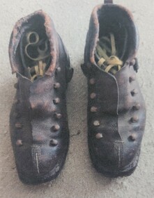
Footwear - Ski Boots 1952
... and then at Falls Creek, Victoria. Mr Smith used the boots until he joined...Falls Creek Historical Society Slalom Street Falls Creek ...These boots were purchased in at "Sports House" in Salzberg, Austria by the donor, Gordon Smith. They were used in Austria and then at Falls Creek, Victoria. Mr Smith used the boots until he joined the Ski Patrol for the SEC when he was provided with new boots. These boots are significant because they are representative of skiing footwear in the early years of skiing at Falls Creek.A pair of leather ski boots from the 1950s. The boots have been resoled by the owner. There are metal hooks to secure the laces which are yellow.ski boots 1950s, ski clothing, gordon smith -
 Falls Creek Historical Society
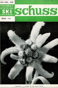
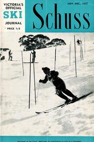
Journal - Schuss Vol. 25. No 8 November - December 1959
... . Page 305 included a photo of Bob Scott of Falls Creek competing... the development of the ski facilities at Falls Creek. Schuss journal Bob ...Schuss was advertised as Victoria’s Official Ski Journal It was issued monthly from 1935 to 1961 except during the war when summer issues covered two months. This continued after the war, but it averaged 10 issues annually over its 25 year life. Schuss was published by the Ski Club of Victoria which had a membership of 38 Ski Clubs and demanded to be recognised as the prime authority on skiing in the state. The other 30 ski clubs with 85% of the members disagreed and the politics of skiing became heated. These clubs formed the Federation of Victorian Ski Clubs with their own journal, Ski Horizon. With the establishment of the Victorian Ski Association, Ski-Horizon published its last issue in Nov - Dec. 1955 and the role of the official journal was fully taken over by “Schuss”. This item is significant because it contains stories, images and information documenting the development of the ski facilities at Falls Creek.The journal includes stories and events chronicling developments in Victoria and internationally. The cover features a photo of an Edelweiss flower. On page 292 the skiers selected for the Olympic Team to compete at the 1960 Winter Olympics were announced. Page 305 included a photo of Bob Scott of Falls Creek competing in the Downhill Championships, whilst page 309 had a short note of congratulations to Cecil Dobson and Mildred Northcote on their engagement.schuss journal, bob scott, cecil dobson -
 Falls Creek Historical Society
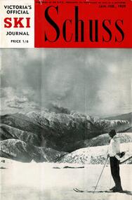
Journal - Schuss Vol. 25. No1 January - February 1959
... at Falls Creek during the holiday period, including Bob Hymans... the development of the ski facilities at Falls Creek. Schuss journal Keith ...Schuss was advertised as Victoria’s Official Ski Journal It was issued monthly from 1935 to 1961 except during the war when summer issues covered two months. This continued after the war, but it averaged 10 issues annually over its 25 year life. Schuss was published by the Ski Club of Victoria which had a membership of 38 Ski Clubs and demanded to be recognised as the prime authority on skiing in the state. The other 30 ski clubs with 85% of the members disagreed and the politics of skiing became heated. These clubs formed the Federation of Victorian Ski Clubs with their own journal, Ski Horizon. With the establishment of the Victorian Ski Association, Ski-Horizon published its last issue in Nov - Dec. 1955 and the role of the official journal was fully taken over by “Schuss”. This item is significant because it contains stories, images and information documenting the development of the ski facilities at Falls Creek.The journal features stories and events chronicling developments in Victoria and internationally. The cover features an Eric Burt photo of a skier on the slopes at Hotham. Page 23 gave an outline of some of the activities that had taken place at Falls Creek during the holiday period, including Bob Hymans operating the tow for tourists. Page 29 announces that a new ski club, St Cuthberts is to be formed for the coming season by Keith Hyland.schuss journal, keith hyland., bob hymans, st cuthberts -
 Lakes Entrance Historical Society
Photograph, 1935
... and Graeme Stony Creek Falls Victoria... (nee Wills) Alexander and Graeme Stony Creek Falls Victoria ...Black and white photograph of Rita (nee Wills) Alexander and Graeme Stony Creek Falls Victoriagenealogy -
 Falls Creek Historical Society
Newspaper - Australia's Playground of the Future
... article about Falls Creek and the Bogong High Plains on 24th...Falls Creek Historical Society Slalom Street Falls Creek ...Australian Magazine (A.M.) published a special three page article about Falls Creek and the Bogong High Plains on 24th August 1954. The article was titled "Australia's playground of the future". Written by Muir Maclaren, it referred to the Bogong High Plains as a comparatively new and unexploited winter playground which could be one of the best snow resorts in the world. There were 13 huts which were at Falls Creek which were there due to "hard work, the grace of God, and the permission of the Victorian State Electricity Commission". A brief history of the Albury Ski Club Lodge was included. In 1954 the Lodge was run byLes Meikle and had the Club had a membership of 200 people. Lodges with accommodation established at this time, with the ability to house a total of 280 people, included Albury, Skyline, Bogong, Myrtleford, Hymans, Dawn, Galleon, Kiewa Valley, Snowden, Nelse, Moroma, Trowalla, St, Trinian's, Bowna and Nissen. Fred Griffith, as a member of the Albury Ski Club and owner of Bowna Lodge escorted the reporter and explained the potential of Falls Creek and the surrounding area to become a year-round playground, a paradise for tourists and a great income-earner for the State.This article and accompanying images are significant because they capture early information about the Bogong High Plains, Falls Creek and its pioneers.A centre spread from a monthly publication featuring text and colour imagesBelow photo Johnny Robertson points out the route of a long, downhill follow-my-leader to expert skiers Bob Howe, Norm Douglas (Albury dentist and President of the Albury Ski Club) and Dick Walpole.albury ski club, bob howe, dick walpole -
 Kiewa Valley Historical Society
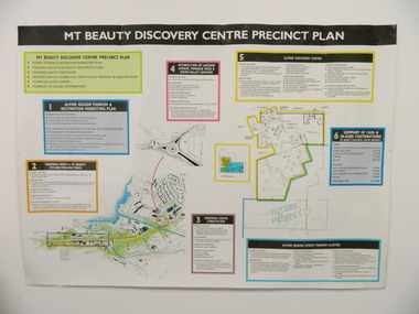
Poster - Mt Beauty Discovery Centre Precinct Plan
... the Government and the Alpine Shire with 'In Kind' assistance from Falls... and the Alpine Shire with 'In Kind' assistance from Falls Creek Resort ...The current (2015) Mt Beauty Tourist Centre site was to be upgraded into a 'Sports Tourism Cluster' with funding from the Government and the Alpine Shire with 'In Kind' assistance from Falls Creek Resort management Board, Parks Victoria and the Local Community & Tourism Industry. This project didn't go ahead.The Mt Beauty town was handed over to the Alpine Shire in the 1960's after completion of the Kiewa Hydro Electric Scheme. Plans for up dating facilities are on-going but are rarely completed. This poster is an example of this.Very large laminated poster depicting 6 points for the Alpine Region Sports Tourism Cluster. Each point has a coloured border and background to black writing. There are 3 maps.mt beauty. tourism. discovery centre. sports cluster. -
 Kiewa Valley Historical Society
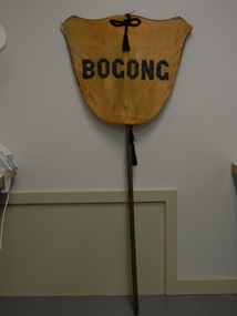
Banner - Bogong
... and Falls Creek and was established by the State Electricity... and/or the team. Bogong is a local town between Mt Beauty and Falls Creek ...Banners were used at schools on sports days to identify the school and/or the team. Bogong is a local town between Mt Beauty and Falls Creek and was established by the State Electricity Commission of Victoria during the construction of the Kiewa Hydro Electric Scheme. The school was opened on 28th Jan. 1941 and closed c1986. The banner probably belonged to the Bogong school and was used for sport carnivals and other events that included mixing with other schools.Wooden pole with yellow/orange satin shield cover on top. Black satin cord with tassels on top and bottom front and back. Black satin letters hand stitched on to form 'Bogong'. Fine black cord around outer edge also hand sewn.Bogongbanner; bogong state school; sport carnivals -
 Lakes Entrance Historical Society
Photograph - Rita (nee Wills) Alexander and baby Graeme, 1938
... and baby Graeme at Stony Creek Falls Victoria... (nee Wills) Alexander and baby Graeme at Stony Creek Falls ...Black and white photograph of Rita (nee Wills) Alexander and baby Graeme at Stony Creek Falls Victoriagenealogy, recreation -
 Falls Creek Historical Society
Journal - Schuss Vol. 23. No.8 November - December 1957
... to stay at Skyline are the only references to Falls Creek .... the development of the ski facilities at Falls Creek. Schuss journal ...Schuss was advertised as Victoria’s Official Ski Journal It was issued monthly from 1935 to 1961 except during the war when summer issues covered two months. This continued after the war, but it averaged 10 issues annually over its 25 year life. Schuss was published by the Ski Club of Victoria which had a membership of 38 Ski Clubs and demanded to be recognised as the prime authority on skiing in the state. The other 30 ski clubs with 85% of the members disagreed and the politics of skiing became heated. These clubs formed the Federation of Victorian Ski Clubs with their own journal, Ski Horizon. With the establishment of the Victorian Ski Association, Ski-Horizon published its last issue in Nov - Dec. 1955 and the role of the official journal was fully taken over by “Schuss”. This item is significant because it contains stories, images and information documenting the development of the ski facilities at Falls Creek.The journal features stories and events chronicling developments in Victoria and internationally. The cover of this issue features a photo by Eric Burt of Nan Dixon, the Victorian Women's Team Captain on the slalom at Buller. Page 255 reveals plans to develop a Community Ski Tow for beginners to be located near Snow Crystal Inn. Page 301 explains the requirement to obtain a permit from the State Electricity Commission and a recommendation to stay at Skyline are the only references to Falls Creek .schuss journal, the ski club of victoria, snow crystal inn, nan dixon -
 Falls Creek Historical Society
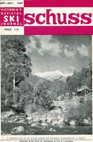
Journal - Schuss Vol. 25. No 7 September - October 1959
... . Skiers in resident at Falls Creek also held a "snow-making... the development of the ski facilities at Falls Creek. Schuss journal ...Schuss was advertised as Victoria’s Official Ski Journal It was issued monthly from 1935 to 1961 except during the war when summer issues covered two months. This continued after the war, but it averaged 10 issues annually over its 25 year life. Schuss was published by the Ski Club of Victoria which had a membership of 38 Ski Clubs and demanded to be recognised as the prime authority on skiing in the state. The other 30 ski clubs with 85% of the members disagreed and the politics of skiing became heated. These clubs formed the Federation of Victorian Ski Clubs with their own journal, Ski Horizon. With the establishment of the Victorian Ski Association, Ski-Horizon published its last issue in Nov - Dec. 1955 and the role of the official journal was fully taken over by “Schuss”. This item is significant because it contains stories, images and information documenting the development of the ski facilities at Falls Creek.The journal includes stories and events chronicling developments in Victoria and internationally. The cover features a photo Mt Buller taken during the National Championships in August 1959.. Page 263 includes an announcement of the birth of a son to Bernhard Plohberger and his wife Trudi. Their son, Gerhardt was the first child born on the Victorian snow fields. Skiers in resident at Falls Creek also held a "snow-making" ceremony on 18th July, led by Julian Brown.schuss journal, bernard plohberger, julian brown -
 Falls Creek Historical Society
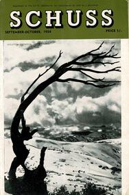
Journal - Schuss Vol. 20. No. 7 September - October 1954
... to the Falls Creek Area in this issue include:- Cover - Features... and internationally. Items related to the Falls Creek Area in this issue ...Schuss was advertised as Victoria’s Official Ski Journal It was issued monthly from 1935 to 1961 except during the war when summer issues covered two months. This continued after the war, but it averaged 10 issues annually over its 25 year life. Schuss was published by the Ski Club of Victoria which had a membership of 38 Ski Clubs and demanded to be recognised as the prime authority on skiing in the state. The other 30 ski clubs with 85% of the members disagreed and the politics of skiing became heated. These clubs formed the Federation of Victorian Ski Clubs with their own journal, Ski Horizon. With the establishment of the Victorian Ski Association, Ski-Horizon published its last issue in Nov - Dec. 1955 and the role of the official journal was fully taken over by “Schuss”. This item is significant because it contains stories, images and information documenting the development of the ski industry in Victoria.The journal features stories and events chronicling developments in Victoria and internationally. Items related to the Falls Creek Area in this issue include:- Cover - Features a photo of Skeleton Snowgum at Mt. Hotham Page 233 - Lower image taken by W. L. Godfrey "On the slope of Mt. McKay, Bogong High Plains, showing Mt. Bogong in the background." Page 234 Top image Photo: H. S. Gibbs On the road to Falls Creek, Mt. Arthur in the background. Lower image: Photo- L. Coote SYDNEY HARBOUR BRIDGE, ROCKEY VALLEY, BOGONG HIGH PLAINS. This structure, well known to skiers who frequent the Plains, has now collapsed, having succumbed to the ravages of many years of use. The structure was erected by Joe Holston with the aid of a few simple tools. It's rustic craftsmanship has always been admired and served to remind skiers of the kindliness and good nature of Joe, who befriended many skiers who visited the High Plains in past years.schuss journal, the ski club of victoria, mt kckay, bogong high plains -
 Falls Creek Historical Society
Photograph - Patsy Finlayson - Australian Downhill Skier
... of Red Onion, Falls Creek. George Shirling arrived in Falls... of Red Onion, Falls Creek. George Shirling arrived in Falls ...This item is from the private collection of George Shirling of Red Onion, Falls Creek. George Shirling arrived in Falls Creek in 1962. He engaged Phil Nowell to build the original Koki Alpine Lodge which opened in 1965 with 14 beds. George operated the lodge with Michael “Baldy” Blackwell as manager. In 1981 he graduated in sport psychology and was invited to become team psychologist for the Australian Winter Olympic team which went to Albertville, France, in 1992. He later owned the Red Onion Chalet. George Shirling passed away on 27th February 2023. He had remained actively involved in Falls Creek and was generous with his time and knowledge, always an amazing supporter of The Falls Creek Museum and Falls Creek Village. Patricia “Patsy” Sydney Russell Finlayson was born on 17 March 1915. In 1935 she was selected for the NSW Ski team and competed at the Australian Championships. Patsy was runner-up in the individual slalom and giant slalom and became the Australian combined champion. In that year she also won the Summit Ski Race at Mount Kosciusko with a time of 9 hours and 37 minutes, breaking the women's record by 1½ hours. In 1936 Finlayson earned national selection for the first Inter Dominion Championship between Australia & New Zealand. She was then selected to represent Australia at the 1939 Nordic World Ski Championship at Zakopane, Poland but was injured during training. She returned to Australia in August 1938 and had to compete in the men's event (placing 4th) as the women's event had been cancelled. In 1969 Finlayson won all her events in the Australian Ski Championships. In 1941, Finlayson was appointed Australia's first female ski instructor. However, she had to resign from the Australian Women's Ski Club as she was no longer considered to be an amateur. This made her ineligible for the Australian or NSW ski championships and the Olympic Games. In 1949, the International Ski Federation (FIS) changed the rules governing amateur standing and Finlayson was allowed to compete at the NSW and Australian Championships. She went on to win all events in both 1949 and 1950. She retired from competitive skiing in October 1950.This item is significant because it features a pioneer of women's skiing in Australia.A black and white image of Patsy Finlayson with her skis and poles. george shirling, red onion, patsy finlayson, women's skiing pioneer -
 Kiewa Valley Historical Society
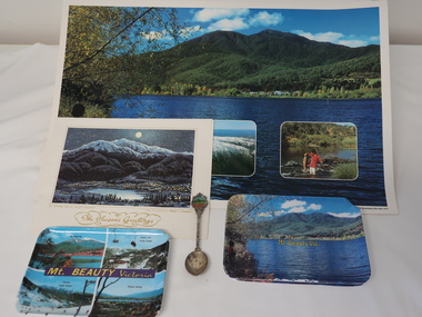
Souvenirs - Mt Beauty
... and Mt Beauty Victoria (4 photos including Mt Bogong, Falls Creek... Victoria (4 photos including Mt Bogong, Falls Creek x2, Kiewa ...Originally an SEC town built for workers on the Kiewa Hydro Electric Scheme. It became a tourist centre from the 1960s.Examples made to increase tourism with historical photos, historical items no longer used or sought after. Items such as these are a different way of advertising to on-line methods used today1. Coloured shiny poster with photos of mountains, river and fishing backed on to orange & white pattern. 2. Christmas card "Mt Bogong and Mr Beauty Township" on the back in gold Markdon Prints, Porpunkah ..."" 3. Plastic coloured trays x3 - Mt Beauty Vic. x2 and Mt Beauty Victoria (4 photos including Mt Bogong, Falls Creek x2, Kiewa Valley.) 4.Silver plated spoon "Mt Beauty Vic." 1. Printed bottom left hand corner "Mount Beauty, Victoria" 2.Centre front "The Seasons Greetings" with title written under painting also "From the painting by Marcus L. O'Donnell" 3. On the back of the tray with 4 photos - embossed "A Starlite Product ..." 4. Embossed on back of handle "Stuart / Silver plated"mt beauty tourism -
 Falls Creek Historical Society
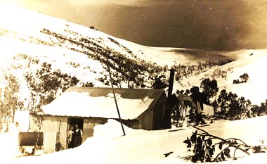
Photograph - SEC hut - home to Skippy and Toni St. Elmo
... to become responsible for early developments at the Falls Creek...Falls Creek Historical Society Slalom Street Falls Creek ...Mavis Grace Lindsay born in 1917 and married Toni St. Elmo in Ballarat on 18 December 1944. She was known as “Skippy” from childhood. They moved from Melbourne in 1945 and spent the year living in Wallace’s Hut. Toni was employed by the State Electricity Commission to record weather-related data. They were to become responsible for early developments at the Falls Creek resort and for promoting a love of skiing. Toni taught Skippy to ski and she practised on the High Plains where she and her husband lived. Toni entering her in the first club championships held by the Bogong Ski Club at Rocky Valley, which he had established. Skippy St Elmo won many ski races during the 1950s and represented Australia in New Zealand. In 1947, the first ski lodge was built by six SEC employees including Toni St Elmo. The lodge was named “Skyline”. In 1957, Toni was involved in building the first rope tow at Falls Creek, called Nissen. He also established the Nissen Ski School. In 1949, Skippy won the Downhill and Combined State Championship held at Mt Buller. In 1950, Skippy was selected to compete in New Zealand with the Victorian team. Skippy trained with the men at the Bogong Ski Club which became a talking point in 1953 when the Albury Ski Club held an Open Championship and Skippy won in the Giant Slalom and Downhill. She went on to win many more races. In 1960, Skippy and Toni said farewell to Falls Creek. Skippy passed away in Queensland in July 2005 and Toni passed away in September of the same year. In November 2006 they were honoured at the Alpine Village at Falls Creek by the spreading of their ashes over Eagle Rock.A black and white photograph of Skippy and Toni St. Elmo standing in the doorway of their hut on the Bogong High Plains. A line of washing stretches behind the hut connected to the outside toilet.skippy st. elmo, toni st. elmo, sec hut skippy and toni st. elmo -
 Falls Creek Historical Society
Photograph - Skippy St Elmo and the Ski Club of Victoria Junior Test
... to become responsible for early developments at the Falls Creek...Falls Creek Historical Society Slalom Street Falls Creek ...Mavis Grace Lindsay born in 1917 and married Tony St. Elmo in Ballarat on 18 December 1944. She was known as “Skippy” from childhood. They moved from Melbourne in 1945 and spent the year living in Wallace’s Hut. Toni was employed by the State Electricity Commission to record weather-related data. They were to become responsible for early developments at the Falls Creek resort and for promoting a love of skiing. Toni taught Skippy to ski and she practised on the High Plains where she and her husband lived. entering her in the first club championships held by the Bogong Ski Club at Rocky Valley, which he had established. Skippy St Elmo won many ski races during the 1950’s and represented Australia in New Zealand. In 1947, the first ski lodge was built by six SEC employees including Toni St Elmo. The lodge was named “Skyline”. In 1957, Toni was involved in building the first rope tow at Falls Creek, called Nissen. He also established the Nissen Ski School. In 1949, Skippy won the Downhill and Combined State Championship held at Mt Buller. In 1950, Skippy was selected to compete in New Zealand with the Victorian team to compete in New Zealand Skippy trained with the men at the Bogong Ski Club and that fact became a talking point in 1953 when the Albury Ski Club held an Open Championship and Skippy won in giant slalom and downhill. She went on to win many more races. In 1960, Skippy and Toni said farewell to Falls Creek. Skippy passed away in Queensland in July 2005 and Toni passed away in the September of the same year. In November 2006 the pair was honoured at the Alpine Village at Falls Creek by the spreading of their ashes over Eagle Rock.Photograph of Ms Skippy Elmo and man at Bogong High Plains on August 25 1945 as well as a framed receipt for the Ski Club of Victoria Junior Test for Ski Instructorsskippy st elmo, skyline lodge, bogong high plains, ski instructor test -
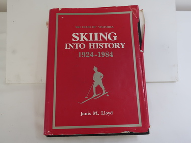 Kiewa Valley Historical Society
Book - Skiing Into History x2, Skiing Into History 1924 - 1984 by Janis M. Lloyd
... chapter 8 "Falls Creek", chapter 9 "Bogong High Plains... 8 "Falls Creek", chapter 9 "Bogong High Plains" and chapter ...The history of the Ski Club of Victoria is also a history of skiing in Victoria. The Club was founded in 1924 when most of the skiing was done on Mt Buffalo. Members of the Ski Club of Victoria fostered and developed Victorian skiing. The book includes chapter 8 "Falls Creek", chapter 9 "Bogong High Plains" and chapter 10 "Mount Bogong"Historical account of skiing in Victoria and in particular the Bogong High Plains, Mt Bogong and Falls Creek all of which are part of the Kiewa Valley and its history. "Cecil Dobson" lived in Mt Beauty.Thick hard covered black book with a bright pink dust cover.731 pages with index and lists, mostly black and white photos and a Contents page including all Victorian Skiing resorts. Published by the Ski Club of Victoria."Many Happy / Birthday / from Cecil Dobson"snow skiing, ski club of victoria, bogong high plains, ski resorts -
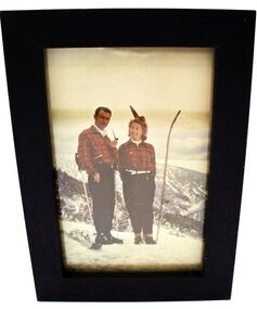
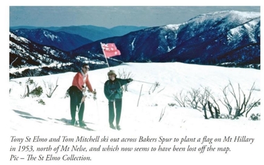 Falls Creek Historical Society
Photograph - Tom Mitchell and Toni St. Elmo plant flag at Mt. Hillary
... common. In 1953 a team from New Zealand visited Falls Creek...Falls Creek Historical Society Slalom Street Falls Creek ...Tom Mitchell was a strong supporter of trans-Tasman ski competitions and in the early 1950s visits between local clubs became common. In 1953 a team from New Zealand visited Falls Creek for the first time. This was only a few months after Edmund Hillary and Nepalese Sherpa Tenzig Norgay became the first climbers confirmed to have reached the summit of Mount Everest. Toni St. Elmo, supported by Tom Mitchell proposed that a peak on the Bogong High Plains northwest of Mt. Nelse should be named Mt. Hillary in honour of the New Zealander's success. He also suggested a ceremony should be held during the visit of members of the New Zealand Ski team to Australia in September 1953. This image from the St. Elimo Collection held by the Falls Creek Historical Society, represents the planting of a New Zealand flag on the mountain during the ceremony.This image is significant because it is part of the St. Elmo Collection which documents early pioneers of Falls Creek and their outstanding contribution to skiing in Australia.A coloured image of two skiers carrying a New Zealand flag across the High Plains.Beneath the image: Tony St Elmo and Tom Mitchell ski out across Bakers Spur to plant a flag on Mt Hillary in 1953, north of Mt Nelse, and which now seems to have been lost off the map. Pic - The St Elmo Collection.tom mitchell, st. elmo collection, toni st. elmo, sir edmund hillary -
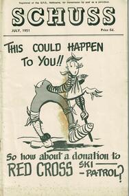 Falls Creek Historical Society
Journal - Schuss Vol. 17. No. 7 July 1951
... to the Falls Creek Area in this issue include:- Page 256 - Explanation...Falls Creek Historical Society Slalom Street Falls Creek ...Schuss was advertised as Victoria’s Official Ski Journal It was issued monthly from 1935 to 1961 except during the war when summer issues covered two months. This continued after the war, but it averaged 10 issues annually over its 25 year life. Schuss was published by the Ski Club of Victoria which had a membership of 38 Ski Clubs and demanded to be recognised as the prime authority on skiing in the state. The other 30 ski clubs with 85% of the members disagreed and the politics of skiing became heated. These clubs formed the Federation of Victorian Ski Clubs with their own journal, Ski Horizon. With the establishment of the Victorian Ski Association, Ski-Horizon published its last issue in Nov - Dec. 1955 and the role of the official journal was fully taken over by “Schuss”. This item is significant because it contains stories, images and information documenting the development of the ski industry in Victoria.The journal features stories and events chronicling developments in Victoria and internationally. Items related to the Falls Creek Area in this issue include:- Page 256 - Explanation of the A.N.S.F. tests and results. Instructions for Test Judges are also included. Mrs. S. St. Elmo is listed as a judge. Page 263 - All skiers visiting Bogong High Plains must comply strictly with the requirements of the State Electricity Commission in regard to transport and general activities in the area. The detailed regulations were set out in the following page.schuss journal, the ski club of victoria, skippy st. elmo, sec regulations -
 Kiewa Valley Historical Society
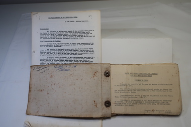
A) Document - The Field Welding of No. 1 Pipeline - Kiewa. B) Book - SECV, Kiewa Hydro Electric Works, Foreman's Guide, A) by J. M. Scott, Welding Inspector B) by State Electricity Commission of Victoria
... the Falls Creek Rd.. The pipeline is 1635m long. It was built... (the Kiewa Hydro Electric Scheme) and can be seen from the Falls ...No. 1 Pipeline heads down the mountain from McKay Power Station (the Kiewa Hydro Electric Scheme) and can be seen from the Falls Creek Rd.. The pipeline is 1635m long. It was built on the mountain rather than as a tunnel inside the mountain - "It was argued that a pressure pipeline on the surface, while not actually cheaper than the tunnel could possibly save one year in construction time.'The document is a report on the welding involved on the No. 1 pipeline. J. M. Scott was the welding inspector for the SECV on the Kiewa Hydro Electric Scheme. The book is produced by the SECV and is the 'Foremen's Guide' and includes rules and regulations across all areas.A) 10 pages of a 'field record' all pages typed on one side. Stapled on top left corner B) Small, fat book c190 pages plus appendix. Thick and 'tattered looking'. Bound by flexible 'cloth?'(linen?) and fastened with 2 rusty fasteners.B) Cover - F/M J. Scott and red SEC stamp. Inside cover: "checked ... 22-8-55" and "checked 18-11-55"j.m. scott welding inspector, no 1 pipeline mckay power station, kiewa hydro electric scheme -
 Falls Creek Historical Society
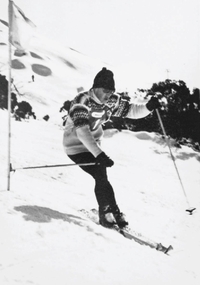
Photograph - Ross Milne
... in Myrtleford, and began skiing at Falls Creek at an early age...Falls Creek Historical Society Slalom Street Falls Creek ...Ross and Malcolm grew up on their family's tobacco property in Myrtleford, and began skiing at Falls Creek at an early age. They were both taught by Austrian Sigi Haberzettl, who was chief coach at Falls Creek for 17 years. Ross went on to win the North-Eastern District Ski Association (NEDSA) Junior Championships for three years in a row. In 1961 Ross was a member of the Australian team which competed against New Zealand in the Inter-Dominion Championships. In 1963, he won the Downhill and Alpine Combined title at the Australian Championships, while placing second in the Grand Slalom event. Ross Milne was selected in the Australian team that participated in the 1964 Olympic Winter Games at Innsbruck, Austria. A few days before the opening of the Games, on 25 January 1964, he tragically lost his life when he crashed into a tree during a training run for the Men's Downhill. He was only 19 years of age.This image is significant because it captures an image of Ross Milne in action.A black and white image of Ross Milne on a downhill run.ross milne, australian olympians, milne brothers -
 Falls Creek Historical Society
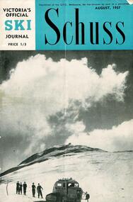
Journal - Schuss Vol. 23. No. 6 August 1957
... a detailed report on Australia's first Ski Chair-Lift at Falls Creek... the development of the ski facilities at Falls Creek. Schuss journal ...Schuss was advertised as Victoria’s Official Ski Journal It was issued monthly from 1935 to 1961 except during the war when summer issues covered two months. This continued after the war, but it averaged 10 issues annually over its 25 year life. Schuss was published by the Ski Club of Victoria which had a membership of 38 Ski Clubs and demanded to be recognised as the prime authority on skiing in the state. The other 30 ski clubs with 85% of the members disagreed and the politics of skiing became heated. These clubs formed the Federation of Victorian Ski Clubs with their own journal, Ski Horizon. With the establishment of the Victorian Ski Association, Ski-Horizon published its last issue in Nov - Dec. 1955 and the role of the official journal was fully taken over by “Schuss”. This item is significant because it contains stories, images and information documenting the development of the ski facilities at Falls Creek.The journal features stories and events chronicling developments in Victoria and internationally. In this issue:- Front Cover features a photo of John Hilton Wood's Snow Cat below the summit of Mt Buller taken by Eric Burt. Page 211 - Stop Press Items including recent Ski event results Page 217 features a detailed report on Australia's first Ski Chair-Lift at Falls Creek, Victoria which began operation on Saturday 27th July. It was built by Bob Hymans to the design of Dr V Hajek.schuss journal, the ski club of victoria, bob hymans -
 Falls Creek Historical Society
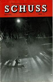
Journal - Schuss Vol. 19. No. 5 July 1953
... to the Falls Creek Area in this issue include:- Page 153... and internationally. Items related to the Falls Creek Area in this issue ...Schuss was advertised as Victoria’s Official Ski Journal It was issued monthly from 1935 to 1961 except during the war when summer issues covered two months. This continued after the war, but it averaged 10 issues annually over its 25 year life. Schuss was published by the Ski Club of Victoria which had a membership of 38 Ski Clubs and demanded to be recognised as the prime authority on skiing in the state. The other 30 ski clubs with 85% of the members disagreed and the politics of skiing became heated. These clubs formed the Federation of Victorian Ski Clubs with their own journal, Ski Horizon. With the establishment of the Victorian Ski Association, Ski-Horizon published its last issue in Nov - Dec. 1955 and the role of the official journal was fully taken over by “Schuss”. This item is significant because it contains stories, images and information documenting the development of the ski industry in Victoria.The journal features stories and events chronicling developments in Victoria and internationally. Items related to the Falls Creek Area in this issue include:- Page 153 - an advertisement for ski lessons, tours and accommodation for skiers with Bob Hymans. A second advertisement for Pearce Bros., General Merchants at Tawonga stated they could arrange for food supplies for clubs or ski parties to be delivered into lodges at city prices. Page 168 feature a photo by H. Gibbs - On the road to Falls Creek, beyond Howman's Gap, showing slopes of of Spion Kopje in the background. Page 177 - The Galleon Ski Club had opened its books to a limited number of Associate Members and offered its Members use of the "GALLEON" Lodge. Associate Membership fee was set at £1/1/- per annum. Lodge fees were 12/6 per day per member. Page 182 announced ALBURY Ski Club's Annual Ball will be held this year on November 28th. The event promised to live up to the reputation of the previous year's very happy "do" at Toonallook Woolshed, and it should be worth going a long way to be in it, even to devoting the whole weekend to a visit. Note the date now.schuss journal, bob hymans, h. gibbs photos, galleon ski club, albury ski club -
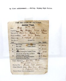 Falls Creek Historical Society
Document - Junior Test Sheet, The Ski Club of Victoria Junior Test
... the first rope tow at Falls Creek, called Nissen. He also...Falls Creek Historical Society Slalom Street Falls Creek ...This is a framed receipt in the name of Skippy St. Elmo for completion of the Ski Club of Victoria Junior test for ski instructor. The test was completed on 25 August 1945 at the Scout Hall, Bogong High Plains. The receipt was found inside the cover of a typed manuscript. Mavis Grace Lindsay (Skippy) born in 1917 and married Tony St. Elmo in Ballarat on 18 December 1944. She was known as “Skippy” from childhood. They moved from Melbourne in 1945 and spent the year living in Wallace’s Hut. Toni was employed by the State Electricity Commission to record weather-related data. They were to become responsible for early developments at the Falls Creek resort and for promoting a love of skiing. Toni taught Skippy to ski and she practised on the High Plains where she and her husband lived. entering her in the first club championships held by the Bogong Ski Club at Rocky Valley, which he had established. Skippy St Elmo won many ski races during the 1950’s and represented Australia in New Zealand. In 1947, the first ski lodge was built by six SEC employees including Toni St Elmo. The lodge was named “Skyline”. In 1957, Toni was involved in building the first rope tow at Falls Creek, called Nissen. He also established the Nissen Ski School. In 1949, Skippy won the Downhill and Combined State Championship held at Mt Buller. In 1950, Skippy was selected to compete in New Zealand with the Victorian team to compete in New Zealand Skippy trained with the men at the Bogong Ski Club and that fact became a talking point in 1953 when the Albury Ski Club held an Open Championship and Skippy won in giant slalom and downhill. She went on to win many more races. In 1960, Skippy and Toni said farewell to Falls Creek. Skippy passed away in Queensland in July 2005 and Toni passed away in the September of the same year. In November 2006 the pair was honoured at the Alpine Village at Falls Creek by the spreading of their ashes over Eagle Rock.This certificate is an early document belonging to Skippy St Elmo, a pioneer of Falls Creek.Framed marking sheet for a Junior ski test for Ms Skippy Elmo at Bogong High Plains on August 25 1945. The test sheet is attached to a white backing paper which has 'My First achievement....skiing. Bogong High Plains' typed on it. The sheet has been framed for displau.skippy st elmo, ski instructor test, ski club of victoria, bogong high plains -
 Kiewa Valley Historical Society
Photographs – Kiewa Cres Mt Beauty. Circa 1993. Set of 12 colour photographs
... of the Mount Beauty, the Kiewa Valley and Falls Creek. The Bright... of the Mount Beauty, the Kiewa Valley and Falls Creek. The Bright ...Established in 1946, during the construction of the Kiewa Hydro Electric Scheme, the township of Mt Beauty was developed by the State Electricity Commission of Victoria to provide additional accommodation for the thousands of workers during the construction of the country’s second largest hydro-electricity scheme. Although these towns were built as temporary accommodation for the workers and their families, many stayed after the scheme finished. Combined with the influx of European migrants, with their rich cultural backgrounds, all played a major part in shaping the future character of the Mount Beauty, the Kiewa Valley and Falls Creek. The Bright Council, now the Alpine Shire took over the control of the township in 1960. This relatively young town of Mount Beauty, along with the surrounding townships of Falls Creek, Bogong, Tawonga South and Tawonga, are all part of a prospering tourist area with excellent services, accommodation, food and a wide range of recreational activities available for all ages. According to Shire records, the population of Mt Beauty has grown from 1,500 in 1981 to 1,800 in 2016 with a projected increase to 2,000 in 2013The photographs taken around 1993 show a prosperous commercial centre catering for both locals and the needs of visitors. It provides a pictorial history of the changes which have occurred in the retail/commercial district of Mt Beauty over the years. It also demonstrates the attention paid by Alpine Shire towards providing accessible recreational green space around the town centre.Set of 12 colour photographs of Kiewa Cres Mt Beauty. Circa 1993 showing retail services and streetscape of the time. No markingskiewa cres mt beauty, mt beauty -
 Kiewa Valley Historical Society
Photographs – Lakeside Avenue, Mt Beauty. Circa 1993. Set of 7 colour photographs
... of the Mount Beauty, the Kiewa Valley and Falls Creek. The Bright... of the Mount Beauty, the Kiewa Valley and Falls Creek. The Bright ...Established in 1946, during the construction of the Kiewa Hydro Electric Scheme, the township of Mt Beauty was developed by the State Electricity Commission of Victoria to provide additional accommodation for the thousands of workers during the construction of the country’s second largest hydro-electricity scheme. Although these towns were built as temporary accommodation for the workers and their families, many stayed after the scheme finished. Combined with the influx of European migrants, with their rich cultural backgrounds, all played a major part in shaping the future character of the Mount Beauty, the Kiewa Valley and Falls Creek. The Bright Council, now the Alpine Shire took over the control of the township in 1960. This relatively young town of Mount Beauty, along with the surrounding townships of Falls Creek, Bogong, Tawonga South and Tawonga, are all part of a prospering tourist area with excellent services, accommodation, food and a wide range of recreational activities available for all ages. According to Shire records, the population of Mt Beauty has grown from 1,500 in 1981 to 1,800 in 2016 with a projected increase to 2,000 in 2013The photographs taken around 1993 show a prosperous commercial centre catering for both locals and the needs of visitors. It provides a pictorial history of the changes which have occurred in the retail/commercial district of Mt Beauty over the years. It also demonstrates the attention paid by Alpine Shire towards providing accessible recreational green space around the town centre.Set of 7 colour photographs of Lakeside Avenue, Mt Beauty. Circa 1993 showing retail services and streetscape of the time. No markingsmt beauty, lakeside ave mt beauty -
 Kiewa Valley Historical Society
Photographs – Tawonga Cres., Mt Beauty. Circa 1993. Set of 4 colour photographs
... of the Mount Beauty, the Kiewa Valley and Falls Creek. The Bright... of the Mount Beauty, the Kiewa Valley and Falls Creek. The Bright ...Established in 1946, during the construction of the Kiewa Hydro Electric Scheme, the township of Mt Beauty was developed by the State Electricity Commission of Victoria to provide additional accommodation for the thousands of workers during the construction of the country’s second largest hydro-electricity scheme. Although these towns were built as temporary accommodation for the workers and their families, many stayed after the scheme finished. Combined with the influx of European migrants, with their rich cultural backgrounds, all played a major part in shaping the future character of the Mount Beauty, the Kiewa Valley and Falls Creek. The Bright Council, now the Alpine Shire took over the control of the township in 1960. This relatively young town of Mount Beauty, along with the surrounding townships of Falls Creek, Bogong, Tawonga South and Tawonga, are all part of a prospering tourist area with excellent services, accommodation, food and a wide range of recreational activities available for all ages. According to Shire records, the population of Mt Beauty has grown from 1,500 in 1981 to 1,800 in 2016 with a projected increase to 2,000 in 2013The photographs taken around 1993 show a prosperous commercial centre catering for both locals and the needs of visitors. It provides a pictorial history of the changes which have occurred in the retail/commercial district of Mt Beauty over the years. It also demonstrates the attention paid by Alpine Shire towards providing accessible recreational green space around the town centre.Set of 4 colour photographs Tawonga Crescent, Mt Beauty. Circa 1993 showing retail services and streetscape of the time No markingstawonga cres mt beauty