Showing 1939 items matching " flood"
-
![Studley Park [Toll] Bridge, Kew](/media/collectors/550653872162f11fb04854aa/items/579ebf04d0cdd117c4c0815f/item-media/579ebf3ad0cdd117c4c0953e/item-fit-380x285.jpg) Kew Historical Society Inc
Kew Historical Society IncPhotograph, Studley Park [Toll] Bridge, Kew, 1870s
‘Studley Park Bridge’ or ‘penny bridge’ linked Church Street in Abbotsford and what is now Yarra Bend Park. The privately constructed bridge opened in 1857, gaining its popular name from the toll charged at the Abbotsford end. The engineer of the 485ft wide bridge was Mr. Austin and the builder was ‘Mr Grant, who threw the bridge over the Niagara’. Following the opening of Johnston Street Bridge, declining tolls led to the Bridge falling into disrepair. Badly damaged by the flood of 1891, the Bridge was compulsorily acquired by the Government in 1899, and later dismantled and sold for firewood.This work forms part of the collection assembled by the historian Dorothy Rogers, that was donated to the Kew Historical Society by her son John Rogers in 2015. The manuscripts, photographs, maps, and documents were sourced by her from both family and local collections or produced as references for her print publications. Many were directly used by Rogers in writing ‘Lovely Old Homes of Kew’ (1961) and 'A History of Kew' (1973), or the numerous articles on local history that she produced for suburban newspapers. Most of the photographs in the collection include detailed annotations in her hand. The Rogers Collection provides a comprehensive insight into the working habits of a historian in the 1960s and 1970s. Together it forms the largest privately-donated collection within the archives of the Kew Historical Society.A print, taken in the 1960s by Dorothy Rogers, from an original albumen silver photograph now in the collection of the Kew Historical Society. The photograph shows the toll bridge (also known as the Penny Bridge) from the northern end."P[enny] Toll Bridge - built 1857. from old photo"studley park bridge, penny bridge, bridge, timber bridge, toll bridge -
 Tarnagulla History Archive
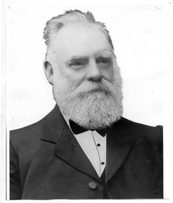
Photograph of John Shields Simpson, circa 1880s
Murray Comrie Collection. Information written by Murray Comrie: John Shields Simpson was born in Scotland in 1831, came to Victoria in 1853 and after mining for a time took up land at what was later to be the Nick O'Time Lead at Poseidon. He took up a store at Newbridge and in 1905 built a hotel alongside the store. Both were severely damaged in floods of the Loddon River in 1909. He was elected to the Tarnagulla Borough Council in 1882 and retained his seat until 1915 when he resigned. He was Mayor of the Borough on five occasions. Monochrome photographic portrait of a bearded man.Accompanying note identifies subject as John Shields Simpson.borough of tarnagulla, john shields simpson, mayor, council, local government, local people, newbridge, store, hotel -
 Bendigo Historical Society Inc.
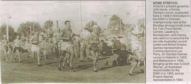
Newspaper - JENNY FOLEY COLLECTION: HOME STRETCH
0 Bendigo Advertiser "The way we were" from Wednesday, June 2, 2004. Home stretch: Victoria's present governor, John Landy, a former Olympic runner, is pictured here in 1948 in third place in the 5,000 mt Victorian championship race at the Bendigo showgrounds (now the Tom Flood Sports Centre). Leading is Bendigonian Jack Davey, who went on to become the six mile Australian record holder and British Empire representative. Coming second is Les Perry, an Olympic games runner in Helsinki in 1952 and Melbourne in 1956. Bringing up the rear is Geoff Warren, an Australian record holder for the 5,000 mt in 1955 and an Empire Games representative in 1954.newspaper, bendigo advertiser, the way we were -
 Kew Historical Society Inc
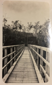
Photograph - Zig-Zag Bridge, 1924
Henry Beater Christian (1886-1962) , was a descendant of one of the earliest settler families in Kew. Employed at the Kew Asylum as a 'public servant', he was a skilled amateur photographer, photographing numerous scenes in Kew and on his travels around Victoria. The majority of his photographs date from 1916 to 1929. His finest photographs are housed in two photograph albums. Digital copy of a photograph from page 8 of the 47-page photograph album containing 261 gelatinous silver images, loaned by Diane Washfold with permission given to digitise and hold a copy in our collection. The Zig-Zag Bridge linked the grounds of the Yarra Bend and Kew Asylums. The wooden bridge was constructed in the 1870s and lasted through numerous floods until its destruction in 1929. A horizontal structure, the walkway was reached via a wooden staircase on the Kew bank of the river. The steps were required due to the different levels of the banks on this stretch of the river. The photo is taken from the Kew side of the river and shows clearly the width of the walkway on top of the bridge. "Zig-Zag Bridge"henry beater christian (1886-1962), landscape photography, kew (vic.) — yarra river, christian-washfold collection, photograph albums, zig-zag bridge -
 Ballarat Heritage Services
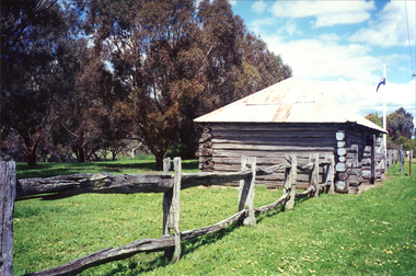
Photograph - Photograph - Colour, Clare Gervasoni, Carisbrook Police Lockup, c1998, c1998
The Logs at Carisbrook was the major gaol in the extensive Carisbrook Police District until 1858, and remained Carisbrook's gaol for low key offenders until about 1900. The lockup was registered by the National Trust on 22/10/1964.Colour photograph of the Carisbrook Police Lockup The Police staton was originally known as the Loddon Punt opening in 1851. The lock up was completed in October 1854 by James Corbet at a cost of 380 pounds. Standing in the park beside Bucknall Street it is the town's one significant historic building. It was originally built on the police paddock adjacent to the primary school and moved to its present site in 1886. The walls are made of interlocking horizontally-laid logs. The shingle roof has been replaced with corrugated iron. The lockup was built on site from local materials, and opened in 1851. It was moved to its current position ofter the original locationn flooded. The police station was closed in 1941. carisbrook, carisbrook lockup, carisbrook police lockup, log cabin, police, police paddock, the logs -
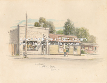 Eltham District Historical Society Inc
Artwork, other - Sketch, E. Foreman, Old property at Eltham Station, c.1980
Situated at 965 Main Road adjacent to the Eltham Railway Station, the Country Art Store was originally a hairdresser and Tattersalls agency In 1968 Pam Robinson and Caroline Shenton opened a small shop on the corner of Main Road and Napoleon Street. Four months later a damaged fire hyrdant flooded the store and ruined all their stock. The pair moved to the former hardresser shop at 965 Main Road, adjacent to the Eltham Railway Station, opposite the Stationmaster's house and opened the Country Art Store and adjacent gallery. At the time the only other shop selling pottery was the Potters Cottage in Warrandyte. During the 1970s the gallery was the Wiregrass Gallery. In 1993, after 25 years operating the Country Art Store, the pair decided to sell up and move to warmer climates. During the course of their business a number of craft shops and galleries opened and closed in Eltham. One such shop was Bimbadeen, next to Ansell and Muir's chicken shop opposite Eltham Lower Park. That business run by Don Brown, then a local artist was taken over as River Clay run by Leo Haanappel and Coeny Dommers but ultimately sat in a flood plain and was demolished. When the Country Art Store became available in 1993, Leo Haanappel and Coeny Dommers took it over. The premises became Platform 3095 cafe around 2015.Old Property at Eltha Station E. Foremanart store, country art store, country art store (eltham), eltham railway station, platform 3095, restaurants, shops, wiregrass gallery -
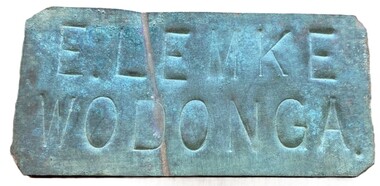 Wodonga & District Historical Society Inc
Sign - Name Plate E. Lemke Wodonga
The dairy farm of Eric Lemke and family was located on the Wodonga flats on the Murray River flood plain, west of the Union Bridge. The property was named "Waterford". They ran a large dairy herd (250 cows) and ran five milk carts to Albury to service their customers. The family bought a second property at Wodonga West, on Felltimber Creek, where herds could be rested before calving, and also as an emergency location for milking during times of flood, which sometimes lasted for several weeks at a time. At other times when the cows finished their lactation period at "Waterford" they would be walked to the Lemke property at Wodonga West, for a rest before calving. When the calves were drafted it was a matter of gathering the cows and calves and walking them back home which was an all day job. During the Depression Mr. Lemke took milk to the out-of-work men who slept under the bridges on the causeway and Mrs Lemke would make bread for them. The men would often work on the farm without wages in return for the Lemke's kindness. The Lemke Family are ranked amongst the top early settlers of the district for their perseverance during the hardships of the early days and during the Great Depression. Lemke Road on Gateway Island, Wodonga is named in their honour.This item has local significance because it came from a prominent Wodonga family business.A small metal tag used to label dairy cans on the property of Eric Lemke.E. LEMKE WODONGAe. lemke wodonga, lemke family, wodonga dairy industry, ernie lemke -
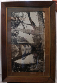 Orbost & District Historical Society
black and white photograph, first half 20th century
This is a bridge across the Snowy River at Orbost. This bridge was built in the 1920s as a road and rail bridge, and was partly washed away by flood waters in 1934. After the end of the first World War the Victorian Railways considered an extension of the railhead across the river at Orbost, and in 1922 a new timber and steel girder structure, a joint Country Roads Board — Victorian Railways venture, was built and completed at a cost of £41,000 (the steel girders came from the Flinders Street viaduct reconstruction). Subsequently it was decided not to take the railway across the river, and the bridge has only been used by road traffic.This is a pictorial record of an early bridge across the Snowy River at Orbost.A very large black / white photograph under glass in a timber frame. It is of a bridge across a river and is framed by trees.bridge snowy-river-bridge road-transport-orbost -
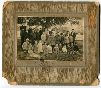 Orbost & District Historical Society
Photograph - Jarrahmond School & pupils c.1914
The Jarrahmond State School No. 2745 near Orbost was one of the earliest in this district. It opened in 1886 at the same time as Orbost and shared a teacher (Campbell McKay who was shortly afterwards replaced by John Rowe who stayed in this position until 1908). The building was financed and built by local farmers on the Stapley property. After a large and damaging flood in the nearby Snowy River in 1893 , the building was shifted to a new location. In 1926, a new building was constructed by the Vic Ed Dept. where it remained until the school was closed in 1948 and children from the Jarrahmond area were then bused to Orbost. Historical significance as one of the earliest photos of Jarrahmond School students.A b/w photo of a group of children and one adult in front of a tree. Children in the front are sitting on the ground, others are standing behind. Photo is mounted onto brown cardboard. On back of photo: Jarrahmond School c.1914. Sally Cole, Angus Cole.education, jarrahmond school, orbost -
 Bendigo Military Museum
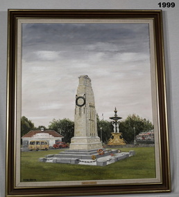
Painting - BENDIGO CENOTAPH, FRAMED, 1988
Bendigo's Cenotaph by Dacre Smyth 1988. Bendigo's War Memorial in the city centre is a half size replica of the famous Cenotaph in London. Some 4-1/2 metres high, the Bendigo RSL President described it as the best country Memorial in Australia during its rededication just before ANZAC Day 1988 following its extensive refurbishment. It had first been dedicated in June 1957 and it is normally flood lit at night. It is not known for sure when the painting was donated to the Bendigo RSL but it was hanging in the Foyer years before the Soldiers Memorial Institute became a Museum in 1998. Frame - Light timber, gold trim, no glass. Original coloured oil painting of the Cenotaph, Bendigo in foreground with Charing Cross buildings & fountain in the background. Label black print on gold bottom centre: "Bendigo's Cenotaph" Rear of painting hand written in black felt pen & black ink: "History of the Cenotaph by Dacre Smyth, 1988" cenotaph, bendigo, painting, brsl, smirsl -
 Orbost & District Historical Society
pamphlets, Princes Freeway - Orbost Section, 1976
Opened by the Hon. J A Rafferty, Minister for Transport, 25 November 1976, the bridge was the first of four bridges to be built as part of the freeway bypass of Orbost. Construction cost $2.4 million. This construction was an important development along the Princes Highway corridor through East Gippsland. The original highway approached the Snowy River at a very poor alignment, and several serious accidents had occurred at the Orbost end. In times of heavy flood, the highway on both sides of the river had been cut by floodwaters and during the 1971 floods, the highest ever recorded, the river was a mile wide at the crossing. Construction of the bridges commenced in January 1975, with an expectation to open the bridge across the Snowy River as soon as possible. Less than two years later, on 25 November 1976, the bridge across the Snowy River was opened to traffic, allowing the old bridge to be demolished. The remainder of the Orbost Bypass, both the floodplain crossings and the eastern section around the township itself, was declared ‘Princes Freeway’ and opened to traffic in December 1977. (ref http://mrv.ozroads.com.au) The Country Roads Board was the government authority for the construction and maintenance of main roads in Victoria between 1913 and 1983. It was succeeded by the Road Construction authority on 1 July 1983 and later merged with the Road Traffic Authority on July 1 1989 to form the Roads Corporation. James Cameron, an Orbost farming pioneer and Member of the Legislative Assembly, fathered the Country Roads Board. The opening of this Snowy River Bridge was an important development in the accessibility to the township of Orbost.Three coloured Country Roads pamphlets for the 'Princes Freeway - Orbost Section". On the front is a coloured photograph of the new construction over the Snowy River at Orbost. Inside is a program for a ceremony for the opening of the new Snowy River Bridge. There is also a black print map of the project. -
 Eltham District Historical Society Inc
Film - Video (Digital), Geoff Paine, Skipper Cottage: Stories of the Nillumbik Shire with Geoff Paine, June 2020
One of a series of videos "Stories from the Nillumbik Shire with Geoff Paine" A brief overview of the Skipper Cottage or Whitecloud and the Bootmakers cottage (mid 1850s) with Sue Thomas, partner of Adam Skipper who have lived there for about 40 years. Includes a view inside the Bootmaker's cottage. Discusses the flood plain and how the house was moved to its present site on high ground due to flooding. The high ground came about due to dumping of rubble from the quarry where the school car park is which was used to source stone to build the schoolhouse across the road. It was moved on horse and wagon approximately 200 metres. The cottage was previously a Cobb and Co stopping station for mail. When Montsalvat was being built in the 1940s, Lena Skipper who was originally from Sydney invested her money into buying Whitecloud rather than putting money into Montsalvat like many others. Upon her death, Matcham Skipper inherited the house. Seaweed was used as insulation in the ceiling and after Matcham owned it a spark from the fireplace set the seaweed on fire and gutted the front of the house which is now all one big room. Also illustrates some of the changes to the house over the years and its construction. The Elm forest has grown naturally from suckers spread from one tree.MP4 Digital file 00:05:50; 674MBvideo recording, bootmakers cottage, lena skipper, lena thomas, matcham skipper, school residence, skipper house, whitecloud cottage -
 Bendigo Historical Society Inc.
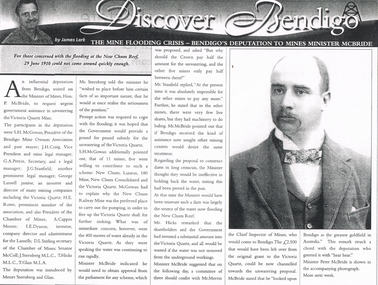
Newspaper - LONG GULLY HISTORY GROUP COLLECTION: THE MINE FLOODING CRISIS - BENDIGO'S DEPUTATION TO THE MINES MINISTER MCBRIDE
Copy of an article from the Bendigo Weekly 25/6/2000 titled The Mine Flooding Crisis - Bendigo's Deputation to Mines Minister McBride by James Lerk. The participants in the deputation were S H McGowan, J H Craig, G A Petrie, J G Stanfield, George Lansell Junior, H E Rowe, A Capper Moore, I E Dyason, S L Stirling, Senator McColl, J Sternberg, T Hicks and T Glass. It was hoped the Government would provide a pound for pound subsidy for the unwatering of the Victoria Quartz. Of the 11 mines, 5 were willing to contribute. The Minister thought dams would be ineffective. There is an accompanying photo of Minister Peter McBride.bendigo, history, long gully history group, the long gully history group - the mine flooding crisis - bendigo's deputation to mines minister mcbride, bendigo weekly 25/6/2000, james lerk, hon p mcbride, victoria quartz mine, s h mcgowan, bendigo mine owners association, j h craig, g a petrie, j g stanfield, george lansell junior, h e rowe, chamber of mines, a capper moore, i e dyason, d l stirling, senator mccoll, j sternberg, t hicks, t glass, new chum, lazarus, 180 mine, new chum consolidated, new chum railway mine, mr merrin, peter mcbride -
 Melbourne Tram Museum
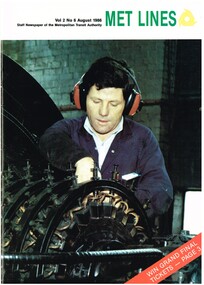
Magazine, Metropolitan Transit Authority (MTA), "Met lines - Vol. 2, No. 6", Aug. 1986
Met lines - Vol. 2, No. 6, August 1986, staff newspaper of the Metropolitan Transit Authority - 20 pages, A4 size when centre stapled, printed on gloss paper. Has tramway related items on: 1 - Cover photo of fitter Saviour Axixa working on a rotary converter at Carlton substation. 2 - Doncaster Bus depot - 25 years of service 3 - The days the rains came - Elizabeth St flooding 1972 - photos by Ray Marsh 4 - Substations power tram network - article on tram substations. 5 - Tram art of a different kind - Stewart Merrett 6 - First new painted tram on line - Transporting Art by Michael Leunigtrams, tramways, transporting art, decorated trams, the met, mta, doncaster, substation, rotary converters, carlton control, elizabeth st, flooding -
 Orbost & District Historical Society
black and white photograph, Howard D. Bulmer, first half 20th century
A new bridge over the Snowy River at Orbost was opened for traffic on June 20th 1922. It was intended as a road and rail bridge, and was again partly washed away by flood waters in 1934. After the end of the first World War the Victorian Railways considered an extension of the railhead across the river at Orbost, and in 1922 a new timber and steel girder structure, a joint Country Roads Board — Victorian Railways venture, was built and completed at a cost of £41,000 (the steel girders came from the Flinders Street viaduct reconstruction). Subsequently it was decided decided not to take the railway across the river, and the bridge was only used by road traffic. This is a pictorial record of an early bridge over the Snowy River at Orbost.A black / white postcard photograph of a bridge across a shallow river with men on horseback underneath.snowy-river-bridge -
 Greensborough Historical Society
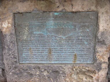
Photograph - Digital image, Dennis Ward, Bridge Plaque - Pioneer Park Greensborough, 27/03/2010
Plaque at Pioneer Reserve Greensborough: "Shire of Diamond Valley. The bluestones used in the construction of this viewing platform and in the carpark entry structure and retaining wall are from the northern arch of Greensborough's first Plenty River Bridge built in the 1860s adjacent to this site. The centre span of the original bridge was removed in 1865 when the western half of the existing bridge was constructed leaving the northern and southern stone arches. The southern arch was retained until floods in 1874 necessitated its removal. The picnic shelter in this reserve was constructed using stone from this abutment. The northern arch was removed in 1983 when widening of the existing bridge commenced."Digital copy of colour photograph.plenty river, pioneer reserve greensborough -
 Eltham District Historical Society Inc
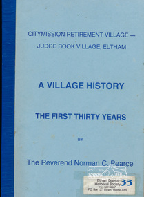
Book, Citymission Retirement Village - Judge Book Village, Eltham: A Village History; the first thirty years / The Reverend Norman C. Pearce, 1986
CityMission Retirement Village, also known as Eltham Retirement Centre, also formerly known as Judge Book Memorial Village, was officially opened on Sunday 28 October 1956. This history documents the first thirty years through to 1986. Founded by the Melbourne City Mission, the significant early history of the "village for the aged" is documented including the various challenges faced including ongoing expansions and building develoment needs and impacts of flooding from the nearby Diamond Creek. It mentions some people associated with the organisation with reference to the Eltham Auxillary which was a group of Eltham residents formed to support the organisation and its residents through activity and fundraising efforts.Softcover; 60p.judge book village, retirement village, melbourne citymission, eltham, aged care, seniors, social service, older people, housing -
 Orbost & District Historical Society
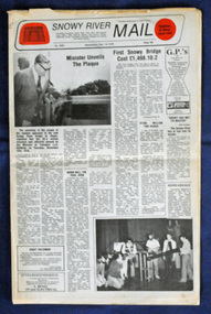
newspaper, Snowy River Mail, 1.12.1976
In early 1974, as an Engineer with the Country Roads Board, David came to Orbost as the Supervising Engineer for the construction of the new bridges which were part of an 8.4km Orbost bypass road design. This was a major project involving not only a new bridge over the Snowy River (including Lochiel Lagoon), but other bridges over Ashby’s Gulch and Watt’s Gulch. These new bridges were opened in November 1976 with the unveiling of a plaque on the eastern end of the $2.4M Snowy River Bridge. The new bridge, built by the CRB at a cost of $2.4 million, is 1.6 metres above the record flood levels of 1971. (ref. May Leatch) This newspaper contains contemporary reports of a significant event in Orbost.A Snowy River Mail newspaper, dated 1.12.1976. It contains news articles, photographs and advertisements. The main article relates to the official opening of the Snowy River Bridge and the unveiling of a plaque on the eastern approach. It also contains a history of the first Snowy River Bridge.snowy-river-bridge orbost-bridges snowy-river-mail -
 Federation University Historical Collection
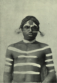
Image - black and white, Barwon River Man (New South Wales)
Digitised directly from 'The Native Races of the British Empire: Victoria' The Barwon River in New South Wales is formed through the confluence of the Macintyre River and Weir River (part of the Border Rivers system), north of Mungindi, in the Southern Downs region of Queensland. The Barwon River generally flows south and west, joined by 36 tributaries, including major inflows from the Boomi, Moonie, Gwydir, Mehi, Namoi, Macquarie, Bokhara and Bogan rivers. During major flooding, overflow from the Narran Lakes and the Narran River also flows into the Barwon. The confluence of the Barwon and Culgoa rivers, between Brewarrina and Bourke, marks the start of the Darling River.Black and white Image of an Aboriginal man from Barwon River, New South Wales. Aboriginal people from six language groups originally occupied the area of the Barwon River wetlands. These were the Ngemba, the Baranbinja, the Murrawari, the Ualayai, the Weilwan, and the Kamilaroi peoples. The Aboriginal people generally used the wetlands for hunting, fishing, and gathering uses, and for cultural association.(Wikipedia) The name "barwon" is derived from the Australian Aboriginal words of barwum or bawon, meaning great, wide, awful river of muddy water; and also baawan, a Ngiyambaa name for both the Barwon and Darling rivers. The history, culture and livelihoods of the local Aboriginal people are closely intertwined with the Barwon River and its associated tributaries and downstream flows. (Wikipedia)aborigine, aboriginal, barwon river -
 Kew Historical Society Inc
Photograph - Willsmere [Kew] Billabong, 1993
Willsmere Park is bounded by the the Yarra River, Green Acres Golf Club, Willow Grove and the Eastern Freeway. The land on which the park is now situated was bought by Thomas Wills at the Crown Land Sales of 1846 (Section 56). From the 1840s to the 1940s it was intensively farmed. The park is dominated by very large playing fields, while planting to the southern boundary was undertaken when the Eastern Freeway was built. It is only along the banks of the Yarra that there is any remnant native vegetation. Willsmere Park is of significance as an area of open land that remains from the flood plain that once dominated northern Kew. (Source: Kew Conservation Study, 1988)Original colour small format polaroid photograph of the 'Kew Billabong' in the Willsmere Park, taken on 16 September 1993."Willsmere Billabong 16.9.93"kew billabong, willsmere park, yarra river -- billabongs -
 Kew Historical Society Inc
Photograph - Willsmere [Kew] Billabong, 1993
Willsmere Park is bounded by the the Yarra River, Green Acres Golf Club, Willow Grove and the Eastern Freeway. The land on which the park is now situated was bought by Thomas Wills at the Crown Land Sales of 1846 (Section 56). From the 1840s to the 1940s it was intensively farmed. The park is dominated by very large playing fields, while planting to the southern boundary was undertaken when the Eastern Freeway was built. It is only along the banks of the Yarra that there is any remnant native vegetation. Willsmere Park is of significance as an area of open land that remains from the flood plain that once dominated northern Kew. (Source: Kew Conservation Study, 1988)Original colour small format polaroid photograph of Willsmere [Kew] Billabong on September 1993."Willsmere Billabong 16.9.93"yarra river -- floods -- kew (vic.), willsmere park -
 City of Greater Bendigo - Civic Collection
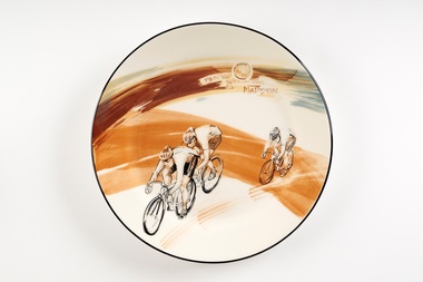
Souvenir - Ceramic platter, Bendigo Pottery, Bendigo International Madison, 2009
First held in 1972 the Bendigo International Madison is an athletics and cycling carvial which takes place in Bendigo ove the March Labour Day long weekend. Events include 400m footraces and the largest outdoor Madison event in the world. The madison is a track cycling race in which 17 pairs of riders race over a hectic 200 laps of the Tom Flood Sports Centre in Bendigo. Riders firstly try to gain a lap advantage over other teams or score sprint points during the 34 sprints dotted throughout the race. At any one time, there are riders sprinting, changing or attacking in this frantic event.Large ceramic plate with hand painted design in underglaze depicting three men bicycle racing.Front; 2009 / Bendigo International Madison Reverse; Signed Faye Brady / 09. Stamped; Bendigo Pottery / 1858 / Australiabendigo pottery, city of greater bendigo sport, city of greater bendigo tourism -
 Stawell Historical Society Inc
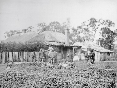
Photograph, Swinton Family Home Station in Glenorchy 1866
Swinton Home Station. Part of a collection of Photographs by Mr. O.G. Armstrong as commissioned by the Shire of Stawell for the Inter-colonial and Paris Exhibition in Melbourne in 1866. Swinton was a family name of John Carfrae, whose father was Thomas Swinton Carfrae of Edinburgh. When John Carfrae came to Ledcourt in 1848 he divided it into three runs, Ledcourt, Swinton and Newington. John Holt occupied Ledcourt and Swindon before 1865, at which time Marcus Clarke was a jackaroo. Alexander Gray came to Swinton in 1881. The Grey family still live at Swinton. The present home was built in 1911 after severe floods in 1909 destroyed the original homestead. Wooden cottage with outbuildings in front of trees. A number of men women and First Nations people standing and sitting in front.stawell aborigional -
 Eltham District Historical Society Inc
Photograph - Digital Photograph, Jim Connor, 21 Brougham Street, Eltham, 18 March 2012
This building at 21 Brougham Street, Eltham, known previously as The Light Factory, now Second Home restaurant, was designed by Alistair Knox and is one of the few commercial buildings he designed. It was a combined residential (rear) and factory (front) development. The Light Factory Gallery; OnlyMelbourne "The Light Factory Gallery was built in 1973 and is a classic example of his design. Exposed soaring six metre Oregon beams, handmade bricks, clerestory windows flood the building with natural daylight giving treetop views of the eucalypts that he designed the building around." The Light Factory Gallery. (2024, March 31). Retrieved from https://www.onlymelbourne.com.au/the-light-factory-galleryjim connor collection, brougham steet, eltham, alistair knox design, industries, restaurants, second home, the light factory gallery -
 Wodonga & District Historical Society Inc
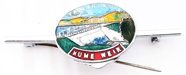
Souvenir - Tallangatta - Hume Weir Tiepin, 1980s
A wide range of items have been created as souvenirs to represent the Hume Weir on the Murray River. Work on Hume Dam started in 1919 and took 17 years to complete. Souvenir items have included chinaware, ashtrays, placemats and small jewellery items such as this tie pin. This tie pin was created as a souvenir for the town of Tallangatta. In the 1950s, the height of the Hume Weir wall was increased, resulting in a nine metre rise in the level of the water in Lake Hume. This necessitated the moving of most of the town of Old Tallangatta due to flooding. The transfer of the township by the State Rivers and Waters Supply Commission to a new site approximately 8 kilometres to the west was completed on 29 June 1956.This item is representative of many items commemorating the Hume Weir and the township of Tallangatta.A small metal and enamelled oval tie pin. It features and image of the Hume Weir.Around top edge in white: TALLANGATTA Around bottom edge" HUME WEIR"hume weir australia, tallangatta, tallangatta - the town that moved -
 Bendigo Historical Society Inc.
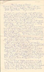
Document - EXTRACT FROM'' WEEKLY TIMES'' RE BOORT AND COPY OF NOTES RE DURHAM OX, 19/04/1941
Handwritten 3-page extract from'' Weekly Times'' (19/4/1941) re early days of Boort - ''Things were tough in Fifty -one (1851) - drought, fire and flood offset Gold''. By E M Webb. On third page is 1/2 page is description of an incident of early days of Gladfield told by Mrs Clarricoates Snr in 1946 - re bogging of beer cargo in creek;. B. copy of notes re early days of Durham Ox, originally written by Charlotte A Ault, Durham Ox and extract from a letter published in the Australian (sic) Post, written by Mr Wm F Sheridan. Reference to the decay of the town due to the railway line going through Pyramid Hill instead of Durham Ox (due to ''private pressure').document, newspaper, weekly times, broot. mrs clarricoates. charlotte a ault. -
 Ballarat Tramway Museum
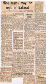
Newspaper, The Courier Ballarat, "Nine trams may be kept in Ballarat", Aug. 1971
Yields information about the closure of the SEC operated Ballarat system - presented in an unorganised manner and without newspaper dates.Set of about 5 newspaper clippings glued to a sheet of lined paper. Main cutting titled "Nine trams may be kept in Ballarat", from The Courier Ballarat, 18/8/1971 (can read date through the back paper), about the number of trams to be kept in Ballarat, the BTPS, removal of the overhead. Other cuttings note the provision of bus stops in Ballarat, a hail storm the previous day (Friday 17/8/2005), floods, the derailment of a tram while on a tour for the Ballarat North Technical School, employment of those employees who had been retrenched and two letters re the replacement of the trams, including the aims of the BTPS to operate in Wendouree Parade. Letter re the BTPS signed by John Anderson. See also Reg item 3165 and 6665 for similar presentations of cuttings.secv, closure, employment, btps, disposal, storms -
 Warrnambool and District Historical Society Inc.
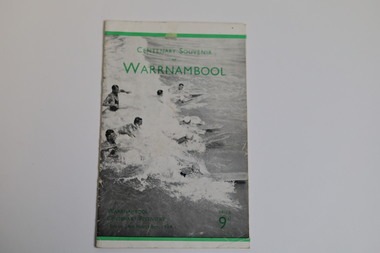
Booklet - Centenary Souvenir of Warrnambool, H. J. Paynter, 1934
In 1934, Victoria and Melbourne celebrated their centenaries. Realising how impossible it would be for the majority of Warrnambool residents to participate in the Victorian celebrations, the organising committee of the Warrnambool Centenary celebrations devised a week long comprehensive programme of activities including exhibitions, a pageant re-enactment at the breakwater and a mass children's display at the showgrounds. Sir Harold Gengoult Smith officially opened the Warrnambool Centenary Exhibition of Arts, Crafts, Antiques and Historical Relics. This booklet was designed and written in 1934 for the Warrnambool Centenary festivities by Frank H. Ford, Lava Street, Warrnambool. The souvenir booklet contains a brief history of Warrnambool, a map and description of Warrnambool and its facilities in 1934.The last three pages include a business directory which would be useful for research.A twenty page booklet printed on shiny paper. The front cover has a black and white photo of nine swimmers in the water (five male & four female) some with surfboards. There is a 4mm green line printed 12mm from the upper edge and a 3mm green line printed 6mm from the lower edge of the cover. There is green printing over the photograph on the front cover. On the rear cover there are two small black and white photographs of an aerial view of the city of Warrnambool and the Hopkins Falls in flood. The green line extend across the rear cover and are intersected by a perpendicular 4mm green line running from the upper to the lower edge 18mm to the left of the spine. Words are printed in black on the rear cover and the printer details are printed in green at the bottom edge.Front cover: Centenary Souvenir of Warrnambool Warrnambool Centenary Festivities 13th to 24th November 1934 Price 9d Rear Cover: Beautiful Warrnambool "City of the West" Victoria Australiawarrnambool, frank h. ford, foyle photos, a. wilkins photos, warrnambool centenary festivities 1934, warrnambool souvenir, warrnambool business directory -
 Bendigo Historical Society Inc.
Newspaper - JENNY FOLEY COLLECTION: SMILES
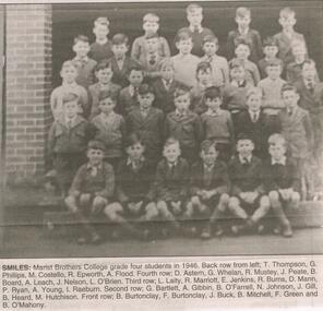
The Marist Brothers arrived in Bendigo in 1893 and began classes for boys in makeshift classrooms at St Killians. By the next year they had moved to a permanent school in McCrae Street. In 1983 Marist amalgamated with St Mary's to form a co-educational school, "Catholic College.Bendigo Advertiser ''The way we were'' from 2003. Smiles: Marist Brothers College grade four students in 1946. Back row from left: T. Thompson, G. Phillips, M. Costello, R. Epworth, A. Flood. Fourth row: D. Astern, G. Whelan, R. Mustey, J. Peate, B. Board, A. Leach, J. Nelson, L. O'Brien. Third row: L. Laity, R. Marriott, E. Jenkins, R. Burns, D. Mann, P. Ryan, A. Young, I. Raeburn. Second row: G. Bartlett, A. Gibbin, B. O'Farrell, N. Johnson, J. Gill, B. Heard, M. Hutchinson. Front row: B. Burtonclay, F Burtonclay, J. Buck, B. Mitchell, F. Green and B. O'Mahony. The clip is in a folder.newspaper, bendigo advertiser, the way we were -
 Bendigo Historical Society Inc.
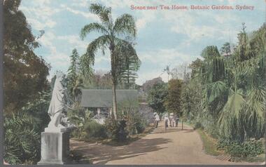
Postcard - Australia, Elliot Collection, 1895 - 1914
Thought to have originated in Austria in 1869, postcards first gained popularity in Australia in the 1890s.They were used to send short messages to friends and family. This collection was generated by Mary Emma Elliot of Talgarno. Talgarno is a rural locality in Victoria, Australia, situated on the southern shoreline of Lake Hume, about 23 km east of Albury-Wodonga. The collection contains postcards from across the world. Mary Emma Sibley was born in Ironbark, Bendigo in 1859. She married James Elliot in 1893 and they settled at “Kelso”, Talgarno. They had two children – Mona and Sibley. Mary Emma Elliot died in Melbourne in 1944, aged 84 years. Australian postcards collected by Mrs James Elliot between 1898 and 1915. 1405.001 Botanic Gardens Sydney 1405.002 Yass 1405.003 Dead Beat 1405.004 Clifton Cliffs, Illawarra 1405.005 The Bridal Veil Falls, Leura 1405.006 Path to Bell Fall, Leura 1405.007 Fern Grotto, Leura 1405.008 Marguerite Cascades, Leura 1405.009 The Botanic Gardens and Harbour, Sydney 1405.010 Botanical Gardens - Sydney 1405.011 National Park, Sydney N.S.W. 1405.012 Caves House, Jenolan Caves, N.S.W. 1405.013 Coast scene, Wattamolla 1405.014 Looking-glass Rock, Hawkesbury River 1405.015 The Harbour, Kiama 1405.016 River Scene, National Park N. S. Wales. 1405.017 Church of England, Cootamundra 1405.018 Flood, 1917 1405.019 Murray River 1405.020 Bathurst postcards, collecting, collections, talgarno