Showing 11430 items
matching map
-
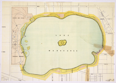 Friends of Ballarat Botanical Gardens History Group
Map - Lake Wendouree Map
Colour photocopy showing some tears in original lake wendouree, ballarat city council -
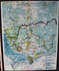 Ringwood RSL Sub-Branch
Map - Vietnam map, 1969-1972 map Vietnam on hard backing
-
 Merbein District Historical Society
Map, Mildura and District Map, After 1954
merbein, yelta, merbein south, the lake, merbein west, birdwoodton -
Merbein District Historical Society
Map, Whitehead's Map of Victoria with Alphabetical Key, 1869
merbein -
University of Melbourne, Burnley Campus Archives
Map, Map of Showgrounds, c. 1970
Tracing paper plan with grid lines. Student project? -
Whitehorse Historical Society Inc.
Map - WW1 Trench map, Belgium collected by C H Honybun, Belgium WW1 map, Aug 1917
WW1 map of Belgium Edition 1. Sheet 28 S.W. and S.E. with trenches in red around the towns of Comines and Warnetonnon-fictionWW1 map of Belgium Edition 1. Sheet 28 S.W. and S.E. with trenches in red around the towns of Comines and Warnetonworld war 1914 - 1918, maps -
Whitehorse Historical Society Inc.
Map - WW1 Trench map, Belgium collected by C H Honybun, Belgium WW1 map Edition 3, Nov 1917
WW1 map of Belgium Edition 3 Sheet 28 S.W. and S.E. Trenches in rednon-fictionWW1 map of Belgium Edition 3 Sheet 28 S.W. and S.E. Trenches in redworld war 1914 - 1918, maps -
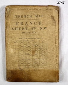 Bendigo Military Museum
Map - TRENCH MAP, FRANCE WW1, 1917
Main Australian areas on this map include “Grevillers, Bapaume and Fremicourt” Item re W.A Alexander No 502 AIF. Refer Cat No 3746.3 for his service details.Trench map, France, sheet No 57N.W. Edition6A, scale 1:20,000, trenches corrected to 7.2.1917, German trenches in red, on rear glossary of terms French to English.map, trench, france -
Whitehorse Historical Society Inc.
Map, Applied for the Roman Catholic Church, 1848
Photocopy of manuscript map inscribed 'Reserve 40 Parish of Nunawading'.Photocopy of manuscript map inscribed 'Reserve 40 Parish of Nunawading'. Streets not named. Note on verso: Site reserved for Roman Catholic Church in Nunawading c1848 (Cr Riversdale and Warrigal Roads)Photocopy of manuscript map inscribed 'Reserve 40 Parish of Nunawading'. churches, catholic church, riversdale road, surrey hills, warrigal road, surrey hills -
Whitehorse Historical Society Inc.
Map, Mitcham, 1880s?
Hand drawn map of area north and south of Whitehorse Road and South of Canterbury Road c.1880-1900.Hand drawn map of area north and south of Whitehorse Road and South of Canterbury Road c.1880-1900. Probably sketched by a McClare descendant. Includes locations and names of settlers of that time.Hand drawn map of area north and south of Whitehorse Road and South of Canterbury Road c.1880-1900. whitehorse road, mitcham, mitcham road, mitcham, l l vale road, vermont, canterbury road, mitcham -
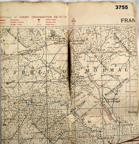 Bendigo Military Museum
Map - FIELD SURVEY MAP, FRANCE WW1, 1918
Area of map shows the River Sambre running from corner left to top corner right, Landrecies, Hachette, Petit Paris to Leval. Item re William Alexander No 502 AIF. refer cat No 3746.3 for his service details.Map, Enemy rear Organization France, Edition 3a, sheet 57A N.W, scale 1:20,000, Field Survey to 24.10.1918.Hand written on rear in black, “57A N.W”map, france, trench -
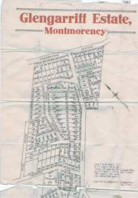 Greensborough Historical Society
Map, Glengarriff Estate Montmorency, 1938c
Estate Agent's plan of Glengarriff Estate, Montmorency, covering LPs 11334 and 11451. Bordered by Sherbourne Avenue, Calrossie Avenue, Montmorency Station and Price AvenueColour photocopy of subdivision map, on two A3 sheets glengarriff estate montmorency, sherbourne avenue montmorency, calrossie avenue montmorency, price avenue montmorency, montmorency station -
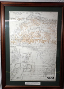 Bendigo Military Museum
Map - MAP, NEW GUINEA FRAMED, 1941 onwards
Map of Western section of New Guinea. Black print on white background with mountain ridges in tan. Mounted with green border & brown wooden frame, glass front & white cardboard backing with wire hanging strap on back. Inset LHS bottom: A: Aroe Island B: KIA Island C: Taniimba IslandPrinted in black at top centre: “NEW GUINEA WESTERN’ Printed on border under map: “These escape maps were carried in the zip pockets of life jackets by fighter pilots in WW2. This map was presented to A.S.R. on the 12/7/79 by Councillor Ian McKenzie, Mayor of Eaglehawk, who served as a fighter pilot in 78th SQN in S.W. Pacific area during 1943-44.”map, new guinea, western, raaf -
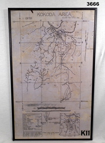 Bendigo Military Museum
Map - MAP, KOKODA MOUNTED, 2nd Aust Field Survey Section, 4.9.1942
Map was compiled from aerial photos without ground control or inspection & with information received from Major CAMERON.Laminated map of Kokoda area on board backing with black border. Black printing on cream / fawn background. White hanging strap on back. Information ledger bottom LHS. Kokoda inset bottom RHS.Printed at top: “KOKODA AREA” Printed at bottom “RHS: K11”map, kokoda, mounted -
Clunes Museum
Map, 1890
Features location of Club Hotel, Union Bank, Engine rooms, Port Phillip Hotel, Pyrites furnace, Battery, Office, Smith Shop,Surface Tramway to BatteryPhotocopy of map/plan of Dixon's New North Clunes, Central Clunes Co. and South Clunes utd showing various shafts and pre-emptive rights. Scale 1 inch = 100 feetOn front in red ink; "drawn in 1890"mine shafts, hotels, plans -
Clunes Museum
Map, CHARLES FENTON, TRADERS OF FRASER STREET CLUNES
4 X SHETS OF PAPER COMMECTED WITH STICKY TAPE SHOWING SHOPS OF FRASER STREET CLUNES WITH THE NAMES OF TRADERS AT EACH SHOP LOCATION. ALTHOUGH UNDATED IT IS EXPECTED THAT THIS MAP DATES TO APPROX 1870C1870fraser street, traders of clunes -
Whitehorse Historical Society Inc.
Map, Ringwood, c1922
Victoria Ringwood Survey map 1 inch to 1 mile.Victoria Ringwood Survey map 1 inch to 1 mile. Covers Eastern suburbs of Melbourne from Richmond to Macclesfield, Heidelberg / Lilydale to Dandenong. Prepared by Commonwealth Section, Imperial General Staff.Victoria Ringwood Survey map 1 inch to 1 mile. eastern suburbs, melbourne, maps -
Whitehorse Historical Society Inc.
Map, Melbourne and suburbs, 1923
Section of map 'Melbourne and Suburbs' compiled at the Department of Lands and Survey, Melbourne by E. S. Hilcke, March 1923, reprinted 1940.Section of map 'Melbourne and Suburbs' compiled at the Department of Lands and Survey, Melbourne by E. S. Hilcke, March 1923, reprinted 1940. Scale 40 chains: 1 inch. - Shire of Blackburn and MitchamSection of map 'Melbourne and Suburbs' compiled at the Department of Lands and Survey, Melbourne by E. S. Hilcke, March 1923, reprinted 1940.department of lands and surve, melbourne and suburbs -
Whitehorse Historical Society Inc.
Map, Parishes of Bulleen, Boroondara, Prahran and Nunawading, 1850
Photocopy of map and tables of corners of allotments.Photocopy of map and tables of corners of allotments. Note on verso: Nunawading, Boroondara, Prahran. Allotments in the Parish surveyed by Lindsay Clarke 1850 (note by Robert Hoddle, surveys by Unwin, Elgar and Dendy indicated)Photocopy of map and tables of corners of allotments. maps, parish of bulleen, parish of boroondara, parish of prahran, parish of nunawading, clarke, lindsay, hoddle, robert -
Whitehorse Historical Society Inc.
Map, City of Whitehorse, 1/03/1995 12:00:00 AM
Map showing streets of the City of Whitehorse from Mullum Mullum Creek to the north to Highbury Road and Warrigal Road in the west, to Heatherdale Road in the east.Map showing streets of the City of Whitehorse from Mullum Mullum Creek to the north to Highbury Road and Warrigal Road in the west, to Heatherdale Road in the east. Prep. by Richard Meloni. Scale 1:15,000Map showing streets of the City of Whitehorse from Mullum Mullum Creek to the north to Highbury Road and Warrigal Road in the west, to Heatherdale Road in the east. city of whitehorse, mullum mullum creek -
Whitehorse Historical Society Inc.
Map, M.M.B.W - Schwerkolt Cottage, 30/04/1968
Extract from M.M.B.W. map No 79 showing proposed main road, open space, residential zones C & D and location of Schwerkolt Cottage. Approved 40/04/1968. 2 copiesschwerkolt cottage, melbourne and metropolitan board of works, eastern freeway -
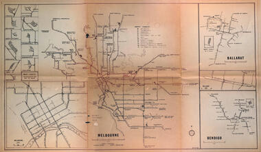 Melbourne Tram Museum
Map - Melbourne - Ballarat - Bendigo Tramways, 23-9-1969
Provides a detailed map of Melbourne, Ballarat and Bendigo tram lines - dated 23-9-1969. Shows street names, depot locations, depot layouts, track details including an insert for Sturt St Ballarat and destination locations. Provides a scale for each system. Not known who prepared the drawing.Yields information about the three operable Victorian systems at the date of preparation.Printed - dyeline? map on a folded sheet of papermap, melbourne, ballarat, bendigo, tramways, diagram -
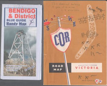 Bendigo Historical Society Inc.
Map - Road maps
BHS CollectionTwo road maps. On, Bendigo & District blue guide handy map the other a road map of Victoria. On the back of the Bendigo map the date October 2000. On the Victoria map the words in pen "This doesn't belong to you, it is mine". L.J. Ellison and a blue stamp of Axedale service station. Aileen and John Ellison Collection.road map, victoria, bendigo -
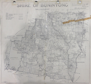 Federation University Historical Collection
Map, Shire of Buninyong, c1970
The Shire of Buninyong was located on the southern side of Ballarat.Two maps of the Shire of Buninyong. .1) Map showing the County divisions, township boundaries, Railway line, State Forest boundary, riding boundary and shire boundary. Identifying words have been added in red and green texta. .2) Shire of Buninyong Parish Plan. Includes Buninyong, Clarendon, Narmbool, Enfield, Lychfield, SCotchman's, Navigators, Warrenheip, Scotsburn, mr Doran, Durham Lead, Cambrian Hill, Napoleons, Garibaldi, Mt Clear, Lal Lal, Bonshaw.1) B.I.A.E., St Martin's, cemetery, mt Buninyong, mt Innes, rly stn shire of buninyong, buninyong, clarendon, narmbool, enfield, lychfield, scotchman's, navigators, warrenheip, scotsburn, mt doran, durham lead, cambrian hill, napoleons, garibaldi, mt clear, lal lal, bonshaw, state forest, elaine, elaine north, cargerie, grenville, mt mercer, millbrook, wallace, yendon, canadian, kaolin deposits, mount helen campus -
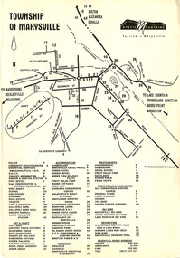 Marysville & District Historical Society
Flyer (Item) - Town map, Mystic Mountains Tourism, TOWNSHIP OF MARYSVILLE, Unknown
A map of the township of Marysville published by Mystic Mountains Tourism in Marysville. The map shows a legend of various services, accommodation sites, shops restaurants and recreation spots in the township.A map of the township of Marysville published by Mystic Mountains Tourism in Marysville.marysville, victoria, australia, mystic mountains tourism, map -
 Bendigo Military Museum
Map - TRENCH MAP, FRANCE WW1, 1918
Areas covered on this map, “Ribemont, Morlancourt, Dernacourt, Fricourt, Mericourt, Saily Le Sec” Item re William Alexander No 502 AIF. Refer Cat No 3746.3 for his service details.Trench map, France, Edition 2 E, sheet 62D N.E, scale 1:20,000, trenches corrected to 28.5.1918, German trenches in red, British in blue.map, france, trench -
University of Melbourne, Burnley Campus Archives
geological survey - Map, Maps of Geelong and Portarlington areas, 1963
A. Coloured geological survey map of Geelong area: showing sedimentary and igneous rock formations and contours. B. Coloured geological survey map of Portarlington, Victoria. By Dept. Of Mines, Melbourne.geological survey, geelong, portarlington -
Beechworth Honey Archive
Map- Eldorado
Compiled from 1971 aerial photography. Printed in 1978.Map shows Eldorado town, Reedy Creek, abandoned gold dredge and Monument Hill. Scale 1:25,000. Printed colour on paper.Map labelled Eldorado. No. 8225-3-4map, eldorado, reedy creek, dredge, monument hill, aerial photography, paper, beechworth honey -
Frankston RSL Sub Branch
Map, SECRET LANDING GROUNDS AUSTRALIA
Large map of aircraft landing grounds located in Australia and some nearby Islands. This map shows landing grounds in use during the latter years of World War 2. The map is in Mercator Projection to the Equatorial Scale 1:4,000,000. The scale is statute miles. Each landing ground location is shown by a symbol indicating category and name. The legend explains the landing ground categories: RAAF Main Landing Grounds, RAAF Emergency Landing Grounds, Seaplane Anchorages, Civil Main Landing Grounds, Civil Emergency Landing Grounds and Cancelled Landing Grounds. The map was revised 4th September, 1945. The map is printed on paper which is attached to a linen backing, The map is quite faded and in a fragile condition. -
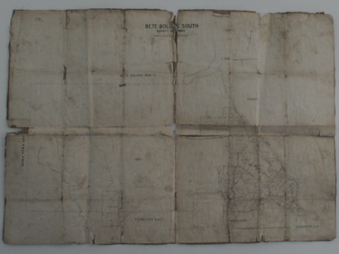 Orbost & District Historical Society
map, Bete Bolong South, March 8 1910
Orbost was at first included in the Bairnsdale Shire from 1882 and was later part of the Tambo Shire. This is a useful research toolA paper shire map of Bete Bolong South, County of Tambo.documents-map-bete-bolong tambo-shire