Showing 10962 items matching " plan"
-
 Tatura Irrigation & Wartime Camps Museum
Document, Sketch plan of Tatura
Sketch plan of Tatura showing names of occupiers of buildings 1n 1904. Possibly drawn by James Reilly from memory.Ink outlines on white paper. -
University of Melbourne, Burnley Campus Archives
Booklet, Kenneth J. Polakowski, Marybyrnong Valley Metropolitan Park Master Development Plan, 1977
parks, melbourne and metropolitan board of works, kenneth j polakowski, centre for environmental studies, university of melbourne -
Federation University Historical Collection
Book, University of Ballarat - Assessment Task: Group Project Assignment, Community & Organisational Plan, 2006
University of Ballarat - Assessment Task: Group Project Assignment, Community & Organisational Plan. Hepburn Shire Council. Student Research Project.White bound book of 30 pages.university of ballarat, mary hollick, hepburn shire council, casey nelson, ash hardy, erin ward, melissa russell, josh wood, importance of tourism to the local economy, assessment of local community issues, attitudes and involvement, assessment of organisational structures and relationships, assessment of the role and effectiveness of the local and regional tourism associations, identification of strategies to achieve better co-ordination of all stakeholders in tourism, conclusion, references, daylesford regional tourism association, hepburn regional tourism association, local tourism assocation, macedon ranges regional tourism association, regional tourism association, judith bedford -
 Bendigo Historical Society Inc.
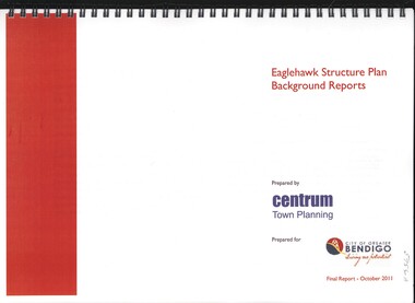
Book - EAGLEHAWK STRUCTURE PLAN BACKGROUND REPORTS, 2011
Eaglehawk Structure Plan Background Reports, 5 reports in 2 volumes identifying a broad range of findings to guide future strategis planning in Eaglehawk, with maps photographs and graphs. Prepared for City of Greater Bendigo: Reports 1 & 2 prepared by Centrum Town Planning (5756a) Reports 3, 4 & 5 prepared by Traffic Works (5756b)Centrum Town Planningbendigo, council, eaglehawk structure plan -
Port Melbourne Historical & Preservation Society
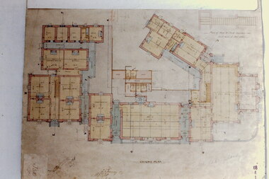
Plan - Additions, Port Melbourne Town Hall, City of Port Melbourne, 8 Jun 1936
Handrawn and coloured plan included with specifications for additions etc. to supper room at Town Hall, Port Melbourne, 1936.Both notes and plan signed by F.C. Cook, City Engineer - 3rd page of notes, top left hand corner of plan.port melbourne town hall, city engineers, fred cook -
 Kew Historical Society Inc
Slide - Architectural Drawing, Kew Public Offices, 1887
A civic campaign for new public offices developed in Kew in the 1880s. After much deliberation, the location chosen was the junction of Bulleen and Cotham Roads. The buildings were designed by George Watson and John Henry Harvey, architects within the Department of Public Works (Victoria). Building was commenced in 1887, and after one year, the buildings were opened. The Post Office was transferred to the new Commonwealth Government in 1901. The Police Station and Court House, sold by the Victorian Government to the City of Boroondara in 2007, are now a community cultural centre and performing arts venue.The buildings were listed on the Victorian Heritage Register Register (HO885) in 1991. They are historically and architecturally significant to the State Of Victoria because Watson and Harvey's designs exhibit diversity in integrating civil offices, they accommodate the apex of road junctions, and they demonstrate a departure from the contemporaneously favoured High Victorian Classical to the Queen Anne style in the design of civic buildings. 35mm colour transparency of an original plan by George Watson and John Henry Harvey, architects of the Department of Public Works (Victoria), in 1887 for New Public Offices at Kew. This plan was copied by the donor from an original held at the Commonwealth Archives in Brighton (Vic). The copy was made to illustrate a report that the donor made on ‘The functional planning design, building materials and construction methods of the Kew Post Office’ as part of course work at RMIT.GROUND PLANkew court house, kew police station, kew post office, architectural drawings, khs - slides, new public offices — kew (vic.), architecture — queen anne style -
Federation University Historical Collection
Plan, University of Ballarat Camp Street Precinct, 2000, c2000
The university aspect of the Camp Street Precinct was named the arts AcademyFramed plans of the Univesity of Ballarat (later Federation University) Camp Street Precinct. .1) Drawing of elevations for the university of Ballarat and the City of Ballarat Camp Street Precinct elevations including a new performing arts Building, Mining Exchange, Visual Arts Building, and Alfred Deakin Place. .2) Camp Street Precinct elevations including the Ballarat Post Office, State Offices and Old Courthouse. camp street, camp street precinct, plans, daryl jackson, arts academy -
 Greensborough Historical Society
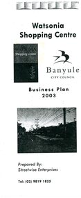
Pamphlet - Leaflet, Banyule City Council, Watsonia Shopping Centre: Business plan 2003, 2003
Watsonia Traders Association approached Banyule Council regarding improvements to the shopping strip. This business plan was prepared by Streetwise Enterprises for Banyule Council.Leaflet, black textwatsonia, watsonia traders, watsonia shopping centre, banyule council, streetwise enterprises -
 Greensborough Historical Society
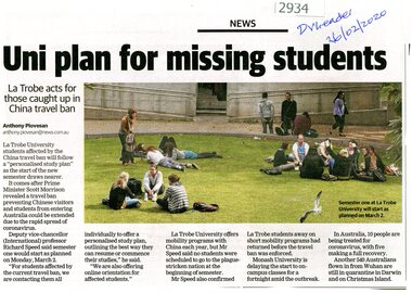
Article - Newspaper Clipping, Anthony Piovesan, Uni plan for missing students, 26/02/2020
Means of providing study plans for Chinese students unable to enter Australia owing to coronavirus restrictions are being provided by La Trobe UniversityNewspaper clipping, text with colour photograph, by Anthony Piovesanla trobe university, international students, covid pandemic -
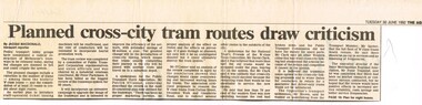 Melbourne Tram Museum
Newspaper, The Age, "Planned cross - city tram routes draw criticism", "Coalition pledges efficiency review of tramways plan", "System hit by years of Neglect" "A new tramway game of nought's and crosses", 14/06/1992 12:00:00 AM
Set of three Newspaper clippings about the proposed cross linking of Melbourne tram routes, written by Jacqui Macdonald and Claude Forrell. .1 - The Age, 30/6/1992 - by Jacqui Macdonald, titled "Planned cross - city tram routes draw criticism", PTC review, W class trams, conductors, PTUA Patrick O'Connor, National Trust David Clark, Opposition Alan Brown and Peter Spyker all commented. Noted by one body a lack of research and surveys. .2 - The Age 1/7/1992 - two items - "Coalition pledges efficiency review of tramways plan", about the plan prepared by the Strategic Review Committee chaired by Peter Parkinson, workplace reforms, cross linking of tram routes, release of the review report the previous day by Peter Spyker. Also quotes Union Secretary Lou DiGregorio and PTUA. The second item - "System hit by years of Neglect" - comments about the report and The Met ticket dispute. Item has a map showing the proposed routes. .3 - The Age 1/7/1992 - "A new tramway game of nought's and crosses" - Claude Forrell - looking at the savings of the plan, conductors, union consent, Government and Coalition attitudes to the proposal of cross linking routes. finances.trams, tramways, operations, transport, public transport, unions, finances, maps, tram routes, w class, national trust, ptua, conductors -
Stawell Historical Society Inc
Plan, Wiring Plans Stawell Hospital, 1933
Blueprint Plans of Wiring for Stawell Hospital 1933. Sheets 1 & 2. Plus Specifications of work to be done in rusted metal Cylinder. Specifications in brown paper folder containing seven (7) typed semi-transparent pagesHospital Plans Healthhospital, plans, health -
Moorabbin Air Museum
Book - Recounting training scheme development as well various personal stories, AIRCREW UNLIMITED The Commonwealth Air Training Plan during World War 2, John Golley, AIRCREW UNLIMITED The Commonwealth Air Training Plan during World War 2, 1993
Recounting training scheme development as well various personal stories, AIRCREW UNLIMITED The Commonwealth Air Training Plan during World War 2Cover jacket showing black outline drawing of pilots scrambling to aircraft, Tiger Moth in background, Harvard passing over, dark brown / blue background, white/yellow writing.non-fictionRecounting training scheme development as well various personal stories, AIRCREW UNLIMITED The Commonwealth Air Training Plan during World War 2 -
Glenelg Shire Council Cultural Collection
Administrative record - Plans, Glenelg Shire Council Plan 2009 - 2013, n.d
Glenelg Shire Council Plan 2009-2013. Full colour booklet. Matt, full-coloured card covers, shiny full colour pages. front cover: Cape Nelson Lighthouse, shire logo. Back cover: Shire logo, contacts.Front: 'Embracing the Future 2009-2013' Printed in whiteglenelg shire, administrative record, local government, planning, strategy -
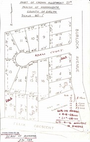 Ringwood and District Historical Society
Map, Subdivision Plan - Adam Court area, North Ringwood, Vic. - circa 1960s
Single page plan printed showing allotments included in un-named subdivision layout surrounding Adam Court, Ringwood North. Subdivision includes Adam Court, Burlock Avenue, and Felix Crescent. Sold allotmenets marked in red, with price notations.Page heading - Part of Crown Allotment 27B Parish of Warrandyte County of Evelyn Scale 60'-1". Rubber stamp imprint and handwritten address at bottom of page - "Binburra Estates Pty. Ltd. 23 Pitt St., Ringwood, 870-1184". -
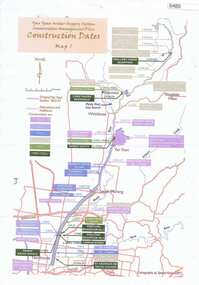 Greensborough Historical Society
Maps, Yan Yean Water Supply System Conservation Management Plan: Construction dates Map 1, 2007_
Plan of Yan Yean Water Supply System, showing natural and constructed features from 1850s to 1930s from Silver Creek Weirs to Eastern Freeway.Printed in colour one side. 3 copieswater supply, yan yean reservoir, plenty river -
 Federation University Historical Collection
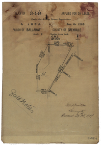
Plan, Parish Of Ballarat Mining Lease applied for by J.H. Dill, 1907, 24/10/1907
Removed from Catalogue No 3601.Lease, plan and field notes showing the survey for the New Kohinoor Comapny Lease No 1205. Scale: 8 chains to 1 inch (1:6336)new kohinoor, survey, robert davidson, j.h. dill, dill, mining, ballarat, new koh-i-nor -
Federation University Historical Collection
Plan, Lease Application Field Notes No. 676. James Richardson, 28 January 1893
Foolscap size hand drawn ink plan near Morgan St and along Yarrowee Creek with State School and Weslyan Church central on page.Titled 'Correct Copy of Fieldnotes Lease Application No 676 JAMES RICHARDSON' also handwritten below this is 'Robert Davidson Surveyor 28th Jany/93' -
 Melbourne Tram Museum
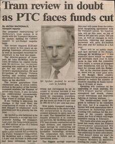
Newspaper, The Age, "Tram review in doubt as PTC faces funds cut", "Tramway plan offers reform at a price", "Report criticises run-down trams", 1992
.1 - Newspaper clipping, The Age 3/8/1992, titled "Tram review in doubt as PTC faces funds cut", written by Jacqui Macdonald Transport Reporter, with a photo of Mr Spyker, Transport Minister. Quotes Mr John McMillan, DG of Transport, re issues of getting cabinet support for planned upgrades, storage of W class trams, unions, conductors, work practices, cross linking of tram routes, rail and buses. .2 - Editorial, The Age, 2/7/1992 - titled "Tramway plan offers reform at a price" - about the proposed plan to restructure the public transport system, W class trams, operations and the revolt against scratch tickets. .3 - Newspaper clipping - The Age - 3/4/1992 titled "Report criticises run-down trams" abort the report by Workshops director John Barry, the condition of W class trams, stored B class trams, sub-stations and maintenance.trams, tramways, budgets, ptc, unions, w class, b class, public transport, funding, operations, scratch tickets -
 Melbourne Tram Museum
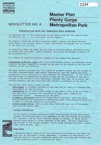
Document - Report, Yan Gaoulil, Conservation Management Plan for The Tramway Signal Cabin, Apr. 2017
Report - 28 A4 pages, double sided stapled in the top left hand corner titled "Conservation Management Plan for The Tramway Signal Cabin, Waiting Shelter and Conveniences at Swanston Street and Victoria Street Melbourne". Prepared by Yan Gaoulil as part of an assignment when undertaking Conservation Management Plan studies. Provides a introduction to the study, history, description, significance, Key Issues, Policy, implementation for the conservation of the building. Includes a Bibliography and Appendices. A second set of documents, five pages stapled in top left hand comer, lists correspondence between the Author and the Museum commencing Dec. 2016.trams, tramways, waiting shelters, franklin st, conservation planning, signal box, swanston st -
 Greensborough Historical Society
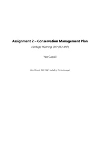
Newsletter, Melbourne & Metropolitan Board of Works, Master Plan Plenty Gorge Metropolitan Park, 1991_06
The Parks Division of the Board was responsible for the preparation of a Master Plan for the management of the Plenty Gorge Metropolitan Park, comprising privately owned land and land owned by the Board and councils.The creation of the park by the Victorian government, to be managed by the Board of Works, guaranteed public access to a large area of land adjacent to the Plenty River Gorge.2p. newsletter, black ink on blue paperNewsletter No. 6plenty gorge park, plenty river -
 Surrey Hills Historical Society Collection
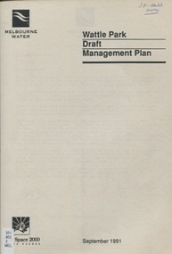
book, Wattle Park Draft Management Plan, Sept 1991
This draft management plan has been developed after consultation with park users, and specific interest groups. It takes into account the findings of market research and community liaison.An A4 sized bookletOn top RH corner of cover: "JF Hall/own"wattle park (box hill, vic) - planning, parks - victoria- box hill- management, gardiner's creek, anniversary trails, vegetation, wattle park chalet, wattle park golf course, land use, melbourne water, riversdale golf course, national trust, riversdale road, surrey hills -
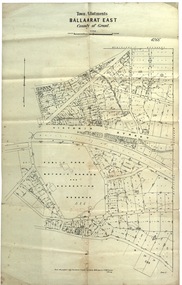 Federation University Historical Collection
Plan, Ballaarat East Town Allotments, 1891, 18/09/1891
Ballarat East was historically a separate municipality than Ballaarat. The streets developed along gold leads and early tracks. The Public Park Botanic Gardens and Recreation Reserve is now Mount Xavier Golf Course, and Ballarat Secondary College Eastern Campus. The section with Bettle's Private Property is now Saint Francis Xavier Primary School. Elford Street now appears to be the continuation of Eureka Street.Plan of Town Allotments for a portion of Ballarat East in the County of Grant. It shows Victoria Street, Clifford Street, Finlay Street, Ryan Street, Bradbury Street, Elford Street, Fussell Street, Jones Street, Park Parade, Ballarat -Geelong Railway, Eureka Street, Ballarat East Public Park Botanic Garden and Recreation Reserve. The only allotment names is Bettle's Private Property. Gift of the Squire Family, 2014ballarat east, ballaarat east, victoria street, ballarat east botanical gardens, richard squire, squire, ryan street, jones street, bradbury street, humffray steet, fussell street, elford street -
National Wool Museum
Book, A brief description of the New Zealand wool selling system and of the New Zealand wool commission and the floor price plan for wool
"A brief description of the New Zealand wool selling system and of the New Zealand wool commission and the floor price plan for wool" - The New Zealand Wool Commission, June 1963wool sales wool marketing wool brokering, new zealand wool commission, wool sales, wool marketing, wool brokering -
 Heidelberg Golf Club
Book, Melbourne Parks and Waterways, Lower Plenty River concept plan: Maroondah Pipe Track to Yarra River, 1994
Lower Plenty River concept plan: Maroondah Pipe Track to Yarra River. Includes suggestion of Plenty River Trail along the west boundary of the Heidelberg Golf Club.66 p., illus., colour map. Also, Draft copy of document.plenty river trail, lower plenty river, heidelberg golf club, mmbw, melbourne parks and waterways -
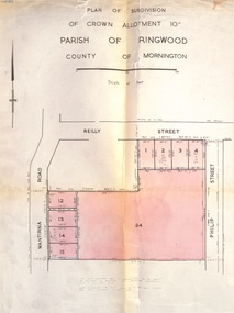 Ringwood and District Historical Society
Document, Plan of Subdivision - Part of Crown Allotment 10A, Parish of Ringwood, County of Mornington - 1957
Map of residential allotments in Wantirna Road and Reilly Street, Ringwood, and Philip Street, Heathmont, Vic.Footnote includes "Lots numbered 5 to 11 and 16 to 23 both inclusive are not included in this plan. Signature of Consulting Engineer - Alan J. Brown BCE, LS, MVIS, Licensed Surveyor, Dillons Buildings, 1 Riversdale Road, Camberwell (Phone) WF3528 dated 1-4-1957. -
Port Melbourne Historical & Preservation Society
Plan - US Military use of Port Melbourne Cricket Ground, Sverdup & Parcel, Architects and Engineers, 1940s
American military plan of Port Melbourne Cricket Ground, alterations to grandstand and rooms during WWII, 1940s.Plan drawn up by Sverdup & Parcel, Architects and Engineers.war - world war ii, sport - australian rules football, sport - cricket, sport - recreational grounds -
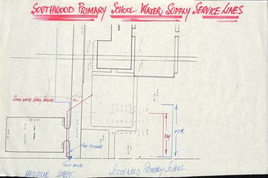 Ringwood and District Historical Society
Plan - Plans, Southwood Primary School, Ringwood, Collection of plans for water supply, sewerage and drainage
folder of paper plansSouthwood P.S. Water Supply, Sewerage & Drainage Plans. Permanent File. To be archived at P.R.O. when no longer required. -
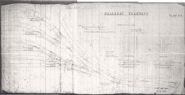 Ballarat Tramway Museum
Drawing, Original by Hadfield's and print by Warren Doubleday, "Ballarat Plan 6", 1995
Yields information about a new depot for Ballarat - the track plan proposed but not followed through for ESCo. Gives the layout and the proposed manufacturer Hadfield's.Print made from a microfilm using a microfilm printer, of "Ballarat Plan 6", a drawing showing trackwork for a new tram depot proposed for the ESCo owned property near the power house. Shows an 8 track tram depot in association with existing Wendouree Parade trackwork. Prepared by Hadfield's Sheffield, drawing No. 6745 as Plan No. 6. Gives details of the proposed rail weights - 90lb and 83lb and location details. Drawing held as one complete assembled print and two part prints. The assembled print was scanned. Note not printed at full size. See Alan Bradley article on the Power Station and power supply to Ballarat.depot, trackwork, ballarat, esco, hadfield's -
 Melbourne Tram Museum
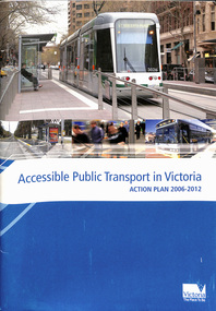
Document - Report, Victorian Government, "Accessible Public Transport in Victoria - Action Plan 2006 - 2012", 2006
.1 - 54 pages, A4 card cover centre stapled titled "Accessible Public Transport in Victoria Action Plan 2006-2012", with a Forward by the Minister for Transport, Peter Batchelor, detailing the context, progress, system wide initiatives, trains, trams, buses, regional trains and coaches and taxis and a summary of actions. Has a table of contents. .2 - 16 pages, A4 card cover, centre stapled titled "Accessible Public Transport in Victoria - Action Plan 2006 - 2012 - Summary" giving a summary of actions, progress chart, and a list of useful contacts. See Reg Item 4592 for the 2013 to 2017 document.trams, tramways, ptv, reports, transport, disability services, public transport -
 Melbourne Tram Museum
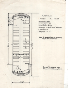
Drawing, Chris Andrews, "Floor plan X class 217", 10/1967
Drawing of the floor plan showing seats, controls, dimensions and technical data for the Birney X class tram No. 217. Drawn by C Andrews 10/1967 and based on MMTB drawing R2462.Yields information about the MMTB Birney X 217Drawing - ink on mylar sheet.tramways, tramcars, x class, tram 217, drawings, birney