Showing 1209 items matching " railway place"
-
 Ballarat Tramway Museum
Document - Guide Book/notes, Tramway Museum Society of Victoria (TMSV), "Guide for Delegates interested in trams", 1970
... Railway Modellers, Melb. 1970. Index, history of TMSV, map of Malvern depot, model trams, exhibition notes, place of Melb. ...Railway Modellers, Melb. 1970. Index, history of TMSV, map of Malvern depot, model trams, exhibition notes, place of Melb. ...Demonstrates notes prepared by the TMSV for tours of the Ballarat and Melbourne systems and the nature of the notes.Five page spirit duplicated notes to act as a guide to visitors to the International Convention of Railway Modellers, Melb. 1970. Index, history of TMSV, map of Malvern depot, model trams, exhibition notes, place of Melb. Tram interest, notes and map on Ballaarat. Missing is pages 6, 7, and 8 - noted in index on page 1. Pdf image of document added 31/10/2013.trams, tramways, melbourne, ballarat, tmsv, model tramways -
 Ballarat Tramway Museum
Photograph - Digital image, Electric Street Railway Journal, "Improved one-man Operation in Australia", "The Principals of Differential Wages in Awards", "One Man cars in Australia"
... Railway Journal about one-man tram operations and wages in Ballarat, written by the ESCo Manager, Mr P J Pringle, Chief Engineer and General Manager. Images i1 and i2 - pages 172 and 173 - letter titled "Improved one-man Operation in Australia", Vol 47 No. 4, 22/1/1916 - describing the operation, and how it operates. Reference to the use in other places...Railway Journal about one-man tram operations and wages in Ballarat, written by the ESCo Manager, Mr P J Pringle, Chief Engineer and General Manager. Images i1 and i2 - pages 172 and 173 - letter titled "Improved one-man Operation in Australia", Vol 47 No. 4, 22/1/1916 - describing the operation, and how it operates. Reference to the use in other places ...Yields information about the operation of one man trams in Ballarat and Bendigo and the provision of information to the American tramway or Street car press. Has a strong association with the Author - Mr Pringle.Series of five digital images of items from the Electric Street Railway Journal about one-man tram operations and wages in Ballarat, written by the ESCo Manager, Mr P J Pringle, Chief Engineer and General Manager. Images i1 and i2 - pages 172 and 173 - letter titled "Improved one-man Operation in Australia", Vol 47 No. 4, 22/1/1916 - describing the operation, and how it operates. Reference to the use in other places in made by the author and the magazine. image i3 - general comment making possible reference to a UK magazine - and how one man tram are worked and their routes, including tickets and wages. From Vol 46, page 23, 4/12/1915. image i4 - "The Principals of Differential Wages in Awards" - Vol 56, No. 19., 6/11/1920 page 965, looking at wages based on locations, arbitration, over WW1, including cost of living and renting. image i5 - "One Man cars in Australia" - Vol 55, No. 24, 12/6/2020 - page 1206, looking at the accident rates between one and two man cars.trams, tramways, one man trams, electric street railway journal, ballarat, bendigo, esco, wages, fares, accidents -
 Sunshine and District Historical Society Incorporated
Document - Public Records Office Victoria Information Sheets, Public Records Office Victoria
... Sheet 8 - Online Catalogue and ordering inquest records Sheet 9 - Service Information Ballarat Archives Centre Sheet 12 - Online Catalogue registering and maintaining a government user account Sheet 13 - Copy and publishing public records Sheet 14 - Records information special access Sheet 15 - Research organisations and search agents Sheet 16 - Research organisations Melbourne Centre for family research Sheet 17 - Research organisations State and Territory Archives, Libraries and BDM Registers Sheet 18 -Research organisations Registry of Births, Deaths and Marriages Sheet 19 - Online Catalogue Registering and maintaining a public user account Sheet 20 - Online Catalogue Searching for records online Sheet 21 - Online Catalogue Ordering records Sheet 22 - Service information PROV records access service charter Sheet 23 - Online Catalogue PROV's digitised records and online indexes Sheet 24 - Copying and publishing public records use of digital camera in PROV reading rooms Sheet 25 - Copying and publishing public records copyright for researchers Sheet 26 - Family history using births, deaths and marriage indexes Sheet 27 - Service information PROV reading room conditions Sheet 49 - Transport Ship's crew Sheet 50 - Transport locating and copying ships passenger lists Sheet 51 - Family history research at PROV Sheet 52 - Transport immigration records Sheet 53 - Transport British post war II immigration Sheet 54 - Transport Ships and shipping movements Sheet 55 - Land, places and local history land records Sheet 56 - Education, health and welfare education records Sheet 57 - Courts and criminal justice convict records Sheet 58 - Courts and criminal justice prison records Sheet 59 - Education, health and welfare mental health records Sheet 60 - Education, health and welfare adoption, wardship and related records Sheet 61 - Courts and criminal justice divorce records Sheet 62 - Transport public transport railways Sheet 64 - Land, places and local history City of Melbourne Sheet 65 - Koorie heritage Koorie family history research at PROV Sheet 66 - Records information PROV's archival control model Sheet 67 - Koorie heritage Aboriginal records at PROV Sheet 68 - Online catalogue ordering wills and probate records Sheet 70 - Courts and criminal justice wills and probate records Sheet 71 - Courts and criminal justice inquest records Sheet 72 - Records information PROV guides numerical list Sheet 73 - Records information PROV guides subject list...Sheet 8 - Online Catalogue and ordering inquest records Sheet 9 - Service Information Ballarat Archives Centre Sheet 12 - Online Catalogue registering and maintaining a government user account Sheet 13 - Copy and publishing public records Sheet 14 - Records information special access Sheet 15 - Research organisations and search agents Sheet 16 - Research organisations Melbourne Centre for family research Sheet 17 - Research organisations State and Territory Archives, Libraries and BDM Registers Sheet 18 -Research organisations Registry of Births, Deaths and Marriages Sheet 19 - Online Catalogue Registering and maintaining a public user account Sheet 20 - Online Catalogue Searching for records online Sheet 21 - Online Catalogue Ordering records Sheet 22 - Service information PROV records access service charter Sheet 23 - Online Catalogue PROV's digitised records and online indexes Sheet 24 - Copying and publishing public records use of digital camera in PROV reading rooms Sheet 25 - Copying and publishing public records copyright for researchers Sheet 26 - Family history using births, deaths and marriage indexes Sheet 27 - Service information PROV reading room conditions Sheet 49 - Transport Ship's crew Sheet 50 - Transport locating and copying ships passenger lists Sheet 51 - Family history research at PROV Sheet 52 - Transport immigration records Sheet 53 - Transport British post war II immigration Sheet 54 - Transport Ships and shipping movements Sheet 55 - Land, places and local history land records Sheet 56 - Education, health and welfare education records Sheet 57 - Courts and criminal justice convict records Sheet 58 - Courts and criminal justice prison records Sheet 59 - Education, health and welfare mental health records Sheet 60 - Education, health and welfare adoption, wardship and related records Sheet 61 - Courts and criminal justice divorce records Sheet 62 - Transport public transport railways Sheet 64 - Land, places and local history City of Melbourne Sheet 65 - Koorie heritage Koorie family history research at PROV Sheet 66 - Records information PROV's archival control model Sheet 67 - Koorie heritage Aboriginal records at PROV Sheet 68 - Online catalogue ordering wills and probate records Sheet 70 - Courts and criminal justice wills and probate records Sheet 71 - Courts and criminal justice inquest records Sheet 72 - Records information PROV guides numerical list Sheet 73 - Records information PROV guides subject list Collection of information sheets on the operation of Public Records Office Victoria (PROV). ...This document came from a workshop that was held by the PROV which members from the Sunshine and District Historical Society attended.Sheet 8 - Online Catalogue and ordering inquest records Sheet 9 - Service Information Ballarat Archives Centre Sheet 12 - Online Catalogue registering and maintaining a government user account Sheet 13 - Copy and publishing public records Sheet 14 - Records information special access Sheet 15 - Research organisations and search agents Sheet 16 - Research organisations Melbourne Centre for family research Sheet 17 - Research organisations State and Territory Archives, Libraries and BDM Registers Sheet 18 -Research organisations Registry of Births, Deaths and Marriages Sheet 19 - Online Catalogue Registering and maintaining a public user account Sheet 20 - Online Catalogue Searching for records online Sheet 21 - Online Catalogue Ordering records Sheet 22 - Service information PROV records access service charter Sheet 23 - Online Catalogue PROV's digitised records and online indexes Sheet 24 - Copying and publishing public records use of digital camera in PROV reading rooms Sheet 25 - Copying and publishing public records copyright for researchers Sheet 26 - Family history using births, deaths and marriage indexes Sheet 27 - Service information PROV reading room conditions Sheet 49 - Transport Ship's crew Sheet 50 - Transport locating and copying ships passenger lists Sheet 51 - Family history research at PROV Sheet 52 - Transport immigration records Sheet 53 - Transport British post war II immigration Sheet 54 - Transport Ships and shipping movements Sheet 55 - Land, places and local history land records Sheet 56 - Education, health and welfare education records Sheet 57 - Courts and criminal justice convict records Sheet 58 - Courts and criminal justice prison records Sheet 59 - Education, health and welfare mental health records Sheet 60 - Education, health and welfare adoption, wardship and related records Sheet 61 - Courts and criminal justice divorce records Sheet 62 - Transport public transport railways Sheet 64 - Land, places and local history City of Melbourne Sheet 65 - Koorie heritage Koorie family history research at PROV Sheet 66 - Records information PROV's archival control model Sheet 67 - Koorie heritage Aboriginal records at PROV Sheet 68 - Online catalogue ordering wills and probate records Sheet 70 - Courts and criminal justice wills and probate records Sheet 71 - Courts and criminal justice inquest records Sheet 72 - Records information PROV guides numerical list Sheet 73 - Records information PROV guides subject list -
 Sunshine and District Historical Society Incorporated
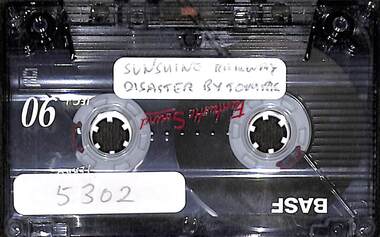
Audio - Sunshine Railway Disaster By Tom Rigg Audio Tape, Tom Rigg, 1998
... Sunshine Rail Disaster Sunshine Railway Disaster Sunshine Station Tom Rigg April 1998 Sunshine Rail Disaster Tom Rigg Audio tape This audio tape has been digitised. Note there is gap in the recording near the start of the tape. This audio tape has been transcribed. No editing of the recording has taken place ...The Sunshine Railway Disaster was a catastrophic rear‑end collision at Sunshine Station on 20 April 1908, killing 44 people and injuring more than 400, the worst rail accident in Victoria’s history. The official inquiry found the Bendigo train passed a signal at danger, likely due to brake failure, and could not stop in time. This accident led to major reforms in Victorian railway safety, including: - Stronger steel‑framed carriages. - Improved braking systems. - Better signalling and traffic control. - The disaster remains a defining moment in Sunshine’s early 20th‑century history. April 1998 Sunshine Rail Disaster Tom Riggsunshine rail disaster, sunshine railway disaster, sunshine station, tom rigg -
 Sunshine and District Historical Society Incorporated
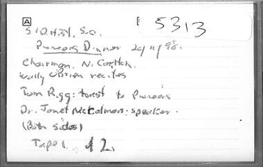
Audio - Sunshine And District Historical Society Pioneers Dinner 1998 Audio Tape, Guest speakers Wally O'Brien, Tom Rigg, Dr Janet McCalmon
... Railway Disaster 1908" detailing all the events before, during and after the accident. Dr Janet McCalman, an Australian social historian, population researcher and author was the guest speaker at the dinner. Tom Rigg Wally O'Brien Dr Janet McCalman Pioneers Dinner Audio Tape This audio tape has been digitised. This audio tape has been transcribed. No editing of the recording has taken place ...The Sunshine and District Historical Society Pioneers’ Lunch / Dinner is an annual event. It’s a commemorative gathering that honours the early settlers, people, community leaders of Sunshine and the surrounding district, events, achievements, etc. At the Pioneers’ Lunch / Dinner, a toast is a ritual and a dedicated moment to honour the original settlers and their contributions, and a guest speaker talks about an interesting subject. Tom Rigg has written a book "Sunshine Railway Disaster 1908" detailing all the events before, during and after the accident. Dr Janet McCalman, an Australian social historian, population researcher and author was the guest speaker at the dinner. Audio Tape This audio tape has been digitised. This audio tape has been transcribed. No editing of the recording has taken place, except where the speaker(s) can be identified.tom rigg, wally o'brien, dr janet mccalman, pioneers dinner -
 Sunshine and District Historical Society Incorporated
Photograph - Sunshine Photographs, Melchior Bajada
... Railway Line works that created additional and longer platforms, pedestrian overpass with lifts for disability access. The City of Brimbank Sunshine Branch Library and Customer Service Centre was built on the former H.V. McKay Massey Ferguson Site. Eventually this complex was demolished to make way for the new Brimbank Community & Civic Centre. Sunshine Library Sunshine Customer Service Centre Hampshire Road Sunshine Millennium Man Village Cinemas Sunshine Market Place ...The Millennium Man was a large metal sculpture commissioned by Village Cinemas Sunshine in the 1990s. Created by BIGFish in Footscray, he was designed as a playful, larger‑than‑life movie mascot. He was a muscular figure holding a globe wrapped in a strip of film, symbolising movies around the world The sculpture and was built from metal, with a bold, comic‑book aesthetic and was only intended originally to last only five years, but he became a local icon instead. The Sunshine Marketplace redevelopment in 2016 included a significant refurbishment of Millennium Man but by 2020, he had deteriorated badly with rust and structural issues, and the fact that people loved climbing on him made him a public liability. The Millennium Man was removed sometime after 2020 and has not returned to the site. The wooden buildings of Sunshine Railway Station were demolished as part of the Region Railway Line works that created additional and longer platforms, pedestrian overpass with lifts for disability access. The City of Brimbank Sunshine Branch Library and Customer Service Centre was built on the former H.V. McKay Massey Ferguson Site. Eventually this complex was demolished to make way for the new Brimbank Community & Civic Centre. 5809.01 - Village Cinemas Sunshine Millennium Man.jpg 5809.02 - Village Cinemas Sunshine Millennium Man.jpg 5809.03 - Sunshine Railway Station Construction During Region Railway Line Works.jpg 5809.04 - Sunshine Branch Library And Customer Service Centre.jpg 5809.05 - Sunshine Branch Library And Customer Service Centre.jpg 5809.06 - Sunshine Branch Library And Customer Service Centre.jpg 5809.07 - Sunshine Branch Library And Customer Service Centre.jpg 5809.08 - Sunshine Branch Library And Customer Service Centre.jpg 5809.09 - Sunshine Branch Library And Customer Service Centre.jpg 5809.10 - Sunshine Branch Library And Customer Service Centre Demolition.jpg sunshine library, sunshine customer service centre, hampshire road, sunshine, millennium man, village cinemas, sunshine market place -
 Canterbury History Group
Photograph - Bronze Plaque in the ground in Theatre Place noting the original railway station entrance off Maling Road, Canterbury, Jan Pigot, 1994
... Bronze Plaque in the ground in Theatre Place noting the original railway station entrance off Maling Road, Canterbury...Place... Signs... Canterbury Railway Station...Coloured photograph of Bronze Plaque in the ground in Theatre Place noting the original railway station entrance off Maling Road, Canterbury...Canterbury Maling Road Theatre Place Signs Canterbury Railway Station Coloured photograph of Bronze Plaque in the ground in Theatre Place noting the original railway station entrance off Maling Road, Canterbury Photograph Bronze Plaque in the ground in Theatre Place noting the original railway station entrance off Maling Road, Canterbury Jan Pigot ...Coloured photograph of Bronze Plaque in the ground in Theatre Place noting the original railway station entrance off Maling Road, Canterburycanterbury, maling road, theatre place, signs, canterbury railway station -
 Ballarat Tramway Museum
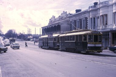
Slide - 35mm slide/s, Peter Moses, 21/08/1971 12:00:00 AM
... place the following day. Has Reid's Coffee Palace building in the background and other buildings on the east side of Lydiard St. North. Two other single truck cars in the photo as are the railway gates at the station. ...Railway Crossing tram 14 tram 42 On back of slide in light black ink "N14 Ballarat / ARHS / 4 trams special Lydiard St" and "P. Moses" in black ink in the upper right hand side of the slide. Photo of SEC Ballarat No. 14 and possibly No. 42 (Briquette roof advertisement and features on the same special trams in Reg. item 2064) waiting in Lydiard St. North for the arrival of the ARHS special on Saturday 21/8/1971 to undertake the last tour of Ballarat Tramways, prior to the closure of the system. The first line closure (Victoria St.) took place ...Photo of SEC Ballarat No. 14 and possibly No. 42 (Briquette roof advertisement and features on the same special trams in Reg. item 2064) waiting in Lydiard St. North for the arrival of the ARHS special on Saturday 21/8/1971 to undertake the last tour of Ballarat Tramways, prior to the closure of the system. The first line closure (Victoria St.) took place the following day. Has Reid's Coffee Palace building in the background and other buildings on the east side of Lydiard St. North. Two other single truck cars in the photo as are the railway gates at the station. Kodak cardboard mount slide, taken by Peter Moses 21 August 1971.On back of slide in light black ink "N14 Ballarat / ARHS / 4 trams special Lydiard St" and "P. Moses" in black ink in the upper right hand side of the slide.tramways, trams, arhs, lydiard st north, railway crossing, tram 14, tram 42 -
 Sunshine and District Historical Society Incorporated
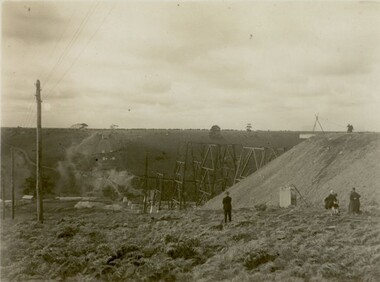
Photograph - Maribyrnong railway bridge construction, 1928
... railway network. Initially the bridge was for goods trains but during the Second World War it was also used by troop trains. When the standard gauge line was built in 1962 all trains to Albury and Sydney have used this route, thus avoiding travelling through Essendon and Pascoe Vale on the suburban tracks. The standard gauge track across the bridge took the place...railway network. Initially the bridge was for goods trains but during the Second World War it was also used by troop trains. When the standard gauge line was built in 1962 all trains to Albury and Sydney have used this route, thus avoiding travelling through Essendon and Pascoe Vale on the suburban tracks. The standard gauge track across the bridge took the place ...One man lost his life during the building of this bridge. The bridge was constructed by the Victorian Railways between 1927 to 1929 to carry a new double track goods line. This enabled trains from all parts of the state except Gippsland to have direct access to the Tottenham marshalling and sorting yards. These yards were constructed in the 1920's to relieve congestion in the Melbourne Yard near Spencer Street station. The congestion was being caused by the construction of suburban passenger platforms associated with the electrification of the suburban railway network. Initially the bridge was for goods trains but during the Second World War it was also used by troop trains. When the standard gauge line was built in 1962 all trains to Albury and Sydney have used this route, thus avoiding travelling through Essendon and Pascoe Vale on the suburban tracks. The standard gauge track across the bridge took the place of one of the broad gauge tracks so broad gauge trains crossing the bridge in either direction have to now use the same track. The bridge is 1,257 feet (383.13 metres) long and 180 feet (54.86 metres) above the water level. It is just 63 feet (19.2 metres) short of a quarter mile in length between abutments. There is a similar bridge on the same railway line crossing the Moonee Ponds Creek between Gowenbrae and Glenroy, however it is smaller at 1060 feet (323.08 metres) length and 115 feet (35.05) height.The bridge is now Victorian Heritage Registered under Number: H1197, and Heritage Overlay Numbers HO5, and HO107. On the Heritage Register it is named RAIL BRIDGE (ALBION VIADUCT). According to the Heritage Report the bridge is scientifically and architecturally important because of its large size, and because of the cost effective design features such as two girders per span (one for each track), the K bracing in the towers, and the broad flange beams as columns. When it was being built it was the largest trestle bridge in Australia, and until the Sydney Harbour bridge was constructed it was the highest railway bridge.449.01 - Maribyrnong railway bridge construction.jpg 449.02 - Maribyrnong railway bridge construction.jpg 449.03 - Maribyrnong railway bridge construction.jpg 449.04 - Maribyrnong railway bridge construction.jpg 449.05 - Maribyrnong railway bridge construction.jpgmaribyrnong river, bridge, quarter mile bridge, trestle bridge -
 Sunshine and District Historical Society Incorporated
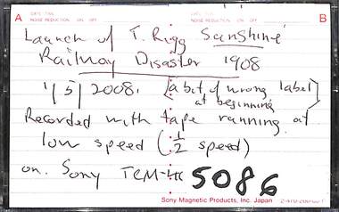
Audio - Launch of Tom Rigg Sunshine Railway Disaster 1908 Book Audio Tape, 11/5/2008
... Railway Disaster 1908 1/5/2008 Audio tape This audio tape has been digitised. This tape was recorded at 1/2 speed. This audio tape has been transcribed. No editing of the recording has taken place ...In April 1908 at the Sunshine Railway Station, a train travelling to Melbourne from Ballarat was struck by a train from Bendigo, resulting in 44 deaths and over 400 injured passengers. Tom Rigg was a former station master at St Albans station and author of a book on the Sunshine Train disaster.Launch of T. Rigg Sunshine Railway Disaster 1908 1/5/2008tom rigg, sunshine train disaster -
 Sunshine and District Historical Society Incorporated
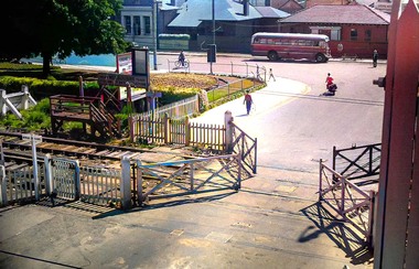
Photograph - Sunshine Station Railway Gates Photograph
... Sunshine had traditional railway gates on Hampshire Road for decades and as traffic increased and Sunshine grew into a major industrial hub, the crossing became a bottleneck. In 1961, the Hampshire Road overpass opened, taking road traffic over the rail line and pedestrians using an underpass. With the bridge and underpass in place...Brimbank Library, 301 Hampshire Road, Sunshine 3020. melbourne Sunshine had traditional railway gates on Hampshire Road for decades and as traffic increased and Sunshine grew into a major industrial hub, the crossing became a bottleneck. In 1961, the Hampshire Road overpass opened, taking road traffic over the rail line and pedestrians using an underpass. With the bridge and underpass in place ...Sunshine had traditional railway gates on Hampshire Road for decades and as traffic increased and Sunshine grew into a major industrial hub, the crossing became a bottleneck. In 1961, the Hampshire Road overpass opened, taking road traffic over the rail line and pedestrians using an underpass. With the bridge and underpass in place, the old railway gates were removed the same year.sunshine railway station, hampshire road, sunshine, sunshine post office, cinderella gardens -
 Marysville & District Historical Society
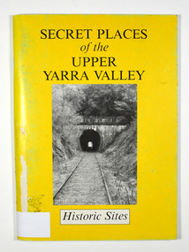
Book, Secret Places of the Upper Yarra Valley-Historic Sites, 1994
... places within the Upper Yarra/ Valley significant to the understanding of our/ heritage./ Aborigines, white explorers, pastoralists, gold/ miners and timber cutters have all left their mark./ These are sites which, despite modern/ development and urbanisation of our valley, are/ still able to give us an insight to an eventful past. Stamp of Marysville & District / Historical Society Inc / P.O. Box 22 / Marysville 3779 Paperback. Front cover has a black and white photograph of a railway ...A book describing historic sites in the Upper Yarra ValleyPaperback. Front cover has a black and white photograph of a railway tunnel at Healesville.A collection of places within the Upper Yarra/ Valley significant to the understanding of our/ heritage./ Aborigines, white explorers, pastoralists, gold/ miners and timber cutters have all left their mark./ These are sites which, despite modern/ development and urbanisation of our valley, are/ still able to give us an insight to an eventful past. Stamp of Marysville & District / Historical Society Inc / P.O. Box 22 / Marysville 3779upper yarra valley, history, historic sites -
 Sunshine and District Historical Society Incorporated
Album - Sunshine Advocate and Brimbank Messenger Newspaper Cuttings 1998 - 2010 Scrapbook, 1998-2001
... Peters Channel Catholic Church|Terry Muscat|Smithy|Norman & Geoff Pomeroy|Sunshine disaster recalled|Sydneham Railway Station|Sunshine Baseball Club|Albert Evans|Sunshine Pool anger|Albion car crash|Jackson School to loose portables|Black Powder Mill|John Kontek|Harvester basic wage case|Sushine Harvester & Offices complex|Deer Park Primary School|Sunshine underpass / subway shame|Albion Railway Station Rolando & Lilia Antonio|Furlong Road tragery|Anita Ciancio & baby Montana kidnapping|Harricks Cottage|Fence to keep out snakes|Shire of Braybrook Financial & Rate records donated to S&DHS|Bikini protest in Council Chambers|Talintyre Reserve name change from Tallintyre Reserve|Peter Somerville and the Blackbird|Keith Miller|Gerald Griggs|St. Albans Hume & Hovell cairn in the move|Iramoo Committee|Shopping bags ban|Harvester City, the making of Multicultural Sunshine book grant|Susan Jennison|Melchior Bajada|Ray Carlton book donation to Sunshine Library|Hampshire Road connection the Market Place...Peters Channel Catholic Church|Terry Muscat|Smithy|Norman & Geoff Pomeroy|Sunshine disaster recalled|Sydneham Railway Station|Sunshine Baseball Club|Albert Evans|Sunshine Pool anger|Albion car crash|Jackson School to loose portables|Black Powder Mill|John Kontek|Harvester basic wage case|Sushine Harvester & Offices complex|Deer Park Primary School|Sunshine underpass / subway shame|Albion Railway Station Rolando & Lilia Antonio|Furlong Road tragery|Anita Ciancio & baby Montana kidnapping|Harricks Cottage|Fence to keep out snakes|Shire of Braybrook Financial & Rate records donated to S&DHS|Bikini protest in Council Chambers|Talintyre Reserve name change from Tallintyre Reserve|Peter Somerville and the Blackbird|Keith Miller|Gerald Griggs|St. Albans Hume & Hovell cairn in the move|Iramoo Committee|Shopping bags ban|Harvester City, the making of Multicultural Sunshine book grant|Susan Jennison|Melchior Bajada|Ray Carlton book donation to Sunshine Library|Hampshire Road connection the Market Place ...These scrap books were put together by Tom Riggs, a past St. Albans Train Station Master, St. Albans Centenary Committee & Sunshine & District Historical Society member and they record a history of a wide range of subjects referring to the Sunshine & District. The following list is only a brief description of each scrapbook. 663.01 - People in official postions 1908|H.V. McKay Factory Gates|Part layout in vicinity of Sunshine Railway Station map 1910|Sunshine Station Signal Box|Harvester Museum|H.V. McKay|H.V. McKay Bulk Store|Sunshine's colorful history|Family of Nathaniel & Mary McKay family tree|Sunshine Smithy|Braybrook residents 1903 & 1906 Sands & McDougal listing|Nat & Joyce Wright|Sunshine Market Palce|Sunshine new police station|Sunshine new post office|S&DHS newspaper articles|Black Powder Mill|Deer Park St. John's Anglican Church|Robert Eric Parsons|Rubblish dumping issue|Bob & Cyril Parsons|Deer Park Bypass|Sunshine Leisure Centre|Sunshine Station Interchange|Dorothy Price|Sunshine Hospital expansion|Albert & Amy Russell|Wally O'Brien|Hospital pedestrain crossing|Our Lady's Primary School reunion|Mytle Baylis|Darling Albion Flour Mill|Pokie machines|Harricks Cottage|Jack Tighe|Cr Brooke Gujinovic New Brimank Mayor|Jack Collins|Isabella Williams Reserve|Cairnlea developement|Albert Holden|Old Sunsine Police Station Sun Crescent|Big bins|Phyllis Vance|Sunshine Pipe Band|Dick & Elsie Whiting|Historic house denmiolition|Boom gate deley|Brian & Doreen Duffy|Beth Argyle|Sunshine Railway Disaster|Les Hunter|Sunshine Pool closure protest|Clare Brennan|Mickey Vautier|Jack Sheridan|Balam Balam Reserve|Gwen Goedecke|Derrimut Hotel & licensee Wal Elms|Jimmy Gaylor|John & Leone Hawking|Centrelink move|Joan Carstairs|Hampshire Road roadworks|Lloyd McCallum postman retires|Mavis Kittelty & Sunshine Croquet Club closes|Frank O'Connor|Beth Argyle, Don Deeble, Shirley Wallace & Jack Sheridan|Sunshine Anglican Church & Father Stuart Soley|Ian Baker|Morris Street proposed flat development protest|Brimbank's rich cultural history|Church of Christ|Doreen Foster & Albion Tennis Club|Francis & Lillian Allen|Sunshine Wesleyan Methodist Churst|3LO-3AR radio transmitter|George & Gloria Hales|H.V. McKay Medal Trade Wing|Lorna Cameron|Noala Flynn|St. Ablans Baptist Church & Ralph Phillips|Apostolic Christian Church|Keilor Christian City Church|Sunshine City Band|Maidstone Our Ladys of Perpetual Church|Waterways|Ron & Margaret Craker 663.02 - Black Powder Mill|St. Albans Greek Orthodox Church of St. Paraskeve|Western Ring Road traffic|Joseph & Frances Testa|Sydneham Kimgdom Hall of Jehovah's Witnesses|Sydenham The Assemblies of God|Michael & Rosalia Skok|Werribee's State Rose Gardens|Tom & Maria Diele|Tom Rigg and the origin of the district's street names|Sunshine & St. Albans Baptist Church|ICI Estate protest|Sunshine Salvation Army Church|Macedonian Orthodox Church|Anita-Marie Neumann|Albanvale path of recongnition|Sunshine Pool action group|Minnie Gorsuch|State Election 2000|Jean Folry & Ilma Weir|Brimbank Uniting Church|Harvester Town book launch - Olwen Ford|Brooke Jujinovic|Keilor Cemetery grave stones|John Howard ignores Braybrook|Norman & Joan Wales|Clare Brennan Drive named after Clare Brennan|Fosseys Sunshine closure|Commonwealth Bank (CBA) Glengala Road closuer|James Frederick McKay|A history of Sunshine|H.V. McKay's Russell Street gates|Barry McMahon|Sunshine Swimming Pool Aquatic centre sale|Keith Buckley|Migrants' move to brave new world|Vasilos & Eugenia Karaoglandis|William Hyett|Darryl Myers|Kathleen Inkster|Sunshine RSL Kevin Keegan, Kevin Bryar & Fred Russell|Barney & Renee Cater|Mona Malouf|George Carter|Sunshine Pottery memorabilia & reunion|Des Johnson Duke Street Aborigine artifacts|Albert Drayton|Two pools planned|Sunshine Pool repairs approved|Olympic Tooch journey through Brimbank|Maurice & Kathleen Sanders|Paul & Suzanna Vicek|Deer Park By Pass Road|Bert & Noreen Craddock|St. Albans Legless Lizards under fire|Sunshine rare orchid scare|St. Albans Road black spot|Viet name for Burke street|Russell Street gates unveiling ceremony|Don & Val Byrnes|Emily Hall|Sunshine Swim centre|Water action plans|Melton Highway sugar gum tree removal by Vicroads|Sunshine Police Station Olympic Rings Brick|Emmaus Catholic School Sydenham opening|Black Powder Mill|Stevens Farm House fire|Yvonne Flack|Frank Gathercole|Commonwealth Bank closurer|Marion Martin|Deer Park State School|Tom & Flo Beagley|Call for railway land buffer|Clarrie Salvador|Braybrook Hotel|Sunshine Harvester Smithy|2000, A year to remember|Bus Re-route hits traders|Sunshine Swimming Pool end of life|Pam Chapman|Prune Goldrick - When the Whistle Blew|Wally O'Brien recalls Deer Park during his childhood|Western Highway / Ballarat Road traffic|Tom Rigg confusing St. Albans bus signs|Rubbish in Deer Park|Phyllis Frost|Basil Morcos|Allan "Titch" Williams|George Thoms|Clarrie Salvator|Tom Dile|Igor Balabin|John McArdie|Sam & Rita Attard|Jack & Dorothy Roberts|Joe De Gabriele|Beth Argyle|John Refshauge surgeon|Bill Fogarity|Brimbank Heritage Listing in peril|Museum of Victoria virtually tour of H.V. McHarvester Factory|Jock McLeod|John & lorna Stainer|Rita Shimmin|Smithy|Nettlefolds - Len Duxon, Betty Scott, Frank Richards, Thelma Burnett, Reg Ratcliffe & Frank Farrugia|Emma Broadhead|Bill Bunting|Gwen Goedecke|Ron Dorre|Sunshine Hospital Redevelopment|Braybrook Squash Centre|Megan Blair|Harvester Town book launch|Tom Rigg rail safty activist|Lloyd & Gislaine Simpson|Sunshine's past revealed|Legless Lizards site Jones Creek|Wetlands|St. Albans time capsule|Cainlea suburb name causing a stir|Agnes Clark|Norman de Pomeroy|Ern & Dot Nicholls|Anton & Maria Gerber|Peter & Margaret McManus|H.V. McKay Offices heritage listing|Cr. Chris Evans out|Two historial walks in Sunshine|Brink Back the H.V. McKay Smithy opening invite|Counicl destroys old files|Harricks Cottage|Special Exhibution Models of Sunshine made farn implements exhibition invite 663.03 - Wally O'Brien|Cr. Chris Evans|Sunshine pool debate|Black Powder Mill|Sydnenham / Hillside Primary School name changes|Say goodbye to Sydnenham, Watergardens|Spalding Reuion|Harry Unger|Gwen Goedecke|Frances Fitzgerald|Preerving Brimbank's significant landmarks|Bernard Reilly kindergarten train|Albert Holden|St. Peters Channel Catholic Church|Terry Muscat|Smithy|Norman & Geoff Pomeroy|Sunshine disaster recalled|Sydneham Railway Station|Sunshine Baseball Club|Albert Evans|Sunshine Pool anger|Albion car crash|Jackson School to loose portables|Black Powder Mill|John Kontek|Harvester basic wage case|Sushine Harvester & Offices complex|Deer Park Primary School|Sunshine underpass / subway shame|Albion Railway Station Rolando & Lilia Antonio|Furlong Road tragery|Anita Ciancio & baby Montana kidnapping|Harricks Cottage|Fence to keep out snakes|Shire of Braybrook Financial & Rate records donated to S&DHS|Bikini protest in Council Chambers|Talintyre Reserve name change from Tallintyre Reserve|Peter Somerville and the Blackbird|Keith Miller|Gerald Griggs|St. Albans Hume & Hovell cairn in the move|Iramoo Committee|Shopping bags ban|Harvester City, the making of Multicultural Sunshine book grant|Susan Jennison|Melchior Bajada|Ray Carlton book donation to Sunshine Library|Hampshire Road connection the Market Place with the Plaza|Girls should be girlsSunshine & Districtsunshine advocate, brimbank messenger, newspaper -
 Victorian Railway History Library
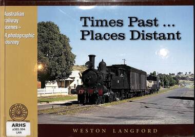
Book, Dare, John, Times Past... Places Distant, 2009
... Railway services. Personal observations. Collections. A photographic journey from the collection of Weston Langford. ill, p.48. Times Past... Places ...A photographic journey from the collection of Weston Langford.ill, p.48.non-fictionA photographic journey from the collection of Weston Langford.photography - weston langford, australian folklore. special subjects: railway services. personal observations. collections. -
 City of Melbourne Libraries
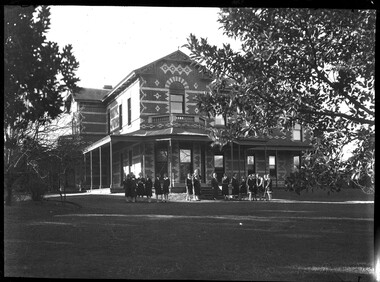
Photograph, Bull, Hugh Jones, 1897-1993, Ruyton Girls School 1933
... railways. The Dictionary of Biography summarises: “As settlers the Henty men were notable not merely for being the first to settle in Victoria but also for their number and quality: a father and seven educated sons experienced in farming and trading, occupations of prime importance to a new colony, and importers of unusually substantial capital in money, skilled workers and thoroughbred stock.” As well as Tarring, the Henty family Melbourne residences included Findon (in Kew, overlooking Studley Park), Offington (St Kilda Road overlooking Albert Park) and Field Place...railways. The Dictionary of Biography summarises: “As settlers the Henty men were notable not merely for being the first to settle in Victoria but also for their number and quality: a father and seven educated sons experienced in farming and trading, occupations of prime importance to a new colony, and importers of unusually substantial capital in money, skilled workers and thoroughbred stock.” As well as Tarring, the Henty family Melbourne residences included Findon (in Kew, overlooking Studley Park), Offington (St Kilda Road overlooking Albert Park) and Field Place ...Published: Age (Melbourne, Vic.: 1854- ), 4 August 1933, page 3 Published title: GIRLS’ SCHOOLS – MODEL YACHTING - FOOTBALL Published caption: The headmistress, Miss H. Daniell, and girls at Ruyton, Selbourne Road, Kew, snapped after school hours. Trove article identifier: http://nla.gov.au/nla.news-article204381763 Research by Project Volunteer, Louise McKenzie: Rather than the people, this charming building takes the eye! Originally named “Tarring”, it was built in 1872 by Mr Henry Henty and his wife Mrs Marion Anne Henty (nee McKellar) for their family. Located at 82 Selbourne Road, Kew, it is described by Melbourne’s Open House organisation as “… a two-storey, polychrome brick mansion built for them by prominent Melbourne architect Albert Purchas. The house and nearly four acres of grounds served as their family home until the death of Marian Henty in 1919. “ (See below for further information on Albert Purchas.) In 1920 it was sold to Ruyton Girls School. Ruyton was established in 1878 by its first principal, Charlotte Anderson (1838-1906), who named it in honour of the parish in Shropshire, England, Ruyton-XI-Towns, where her great-great-grandfather David Evans had been vicar. Its motto is Recte et Fideliter, meaning "Upright and Faithful", which is also the name of the school song. The original school, one of Victoria’s oldest independent schools for girls, was located at the home of Mrs Anderson at 63 High Street South, Kew. In 1882 she moved the school to Edgecombe in Studley Park Road. Mrs Anderson retired due to ill health and sold the school to her friend Miss Eliza Bromby. One of Ruyton's four Houses, Anderson, is named for Charlotte Anderson. When Ruyton Girls School was moved to the site in 1920 it established the building as a Boarding House, and renamed the building “Henty House” in honour of its original owners. Today the school remains an all girls’ school, and pays tribute to its founder and the historic significance of Henty House and its magnificent Moreton Bay Fig tree, which still stands today. The building retains many original, Victorian-era features, while also showing the layers of change, made over the decades in order to meet the evolving needs of one of Melbourne’s leading schools. The headmistress mentioned in the caption for MCK016 is Miss Hilda Daniell, shown standing in front of Henty House in the midst of a group of Ruyton girls in their school uniforms, some holding hockey sticks. Miss Daniell was the longest serving Principal of Ruyton 1913-1952. She was originally a student in 1893, then joined the teaching staff in 1898. It was under her leadership that the School purchased and moved to “Tarring”. The boarding house included a flat for Hilda to live onsite. An article in the Ruyton Heritage Collection – Bedford Series, dated 21 May 2021 cites that Miss Daniell “was affectionately known as “Dream” by Ruytonians of her era” apparently due to a tendency to quiet reflection. The article continues, “After her retirement in 1952 Miss Daniell was awarded an Order of the British Empire for her many services to education, an award she received from the hands of the Queen during the 1954 Royal Tour. Also in 1952, the Kew Council honoured her by renaming Brougham Place as ‘Daniell Place’.” Arthur Purchas, architect: The architect responsible for the design of “Tarring”. Arthur Purchas, was extremely active and highly regarded at this time. Born in Wales in 1825, he emigrated to Melbourne in 1851 and soon established a private practice as a surveyor and architect, with offices variously in Little Collins, Queen Street, Chancery Lane, and finally 462 Little Collins Street. Wikipedia notes in an early reference to Purchas that “An early story is that one of his first jobs, when he would have been about 25 years old, was a position under Surveyor-General Robert Hoddle, and disagreeing with him over the line for St Kilda Road, appealed to Governor La Trobe, and successfully got the road diverted around the hill which eventually became the site of the Shrine of Remembrance. There may not be much truth to this, since by 1851 St Kilda Road was already a well worn track running around the hill, the top of which La Trobe had reserved for a Government House in 1840.” The timing of Purchas’s arrival in Melbourne was perfect. The Victorian gold rush of the 1850’s generated enormous wealth in Melbourne, and a building boom followed. The Wikipedia entry continues … that alone, or with his brother in law Charles R Swyer, “Purchas is said to have designed over 140 houses, offices, churches, banks and cemetery buildings in Victoria in his long career. Berkely Hall, St Kilda dating from 1854 is one of his first buildings, and still exists, though the original house is obscured by an early C20th verandah. Another notable early design was the head office of the Melbourne Savings Bank, built on the corner Flinders Lane and Market Street in 1857-58, in an elaborately detailed Renaissance Revival style. His churches were mostly Gothic Revival, built for the Anglican Church, along with some parsonages, while most of the bank buildings were Renaissance Revival designs for the Bank of Australasia. He also designed city buildings in the 1860s and 70s, such as the Mutual Insurance Co, Northern Insurance Co, and the first premises for George & George, destroyed by fire in 1889. One of his most outstanding designs is St George's Presbyterian Church in Chapel Street, St Kilda (1877–80), in a striking polychrome brick Gothic Revival style, unusually carried on through to the interior. Purchas produced one of the few published maps and compilations of the early pastoral settlers runs in Victoria in 1853. In the same year he designed the layout of the Melbourne General Cemetery, the first 'garden' cemetery in Victoria, a curvilinear layout with extensive plantings, as well as the gate lodge and gates (the gates lodge were demolished and the gates relocated to their present position in the 1930s). He was a long time member of the Cemetery Trust, serving as secretary from 1876-1886. He was also Chairman of the Boroondara General Cemetery Board of Trustees 1867 to 1909, and designed many aspects of the cemetery, including the landscape, the cast iron entrance gates (1889), the rotunda (1890) and the surrounding brick wall (1895–6). Purchas was a keen inventor having applied for a patent for an invention for lighting a railway carriage with gas in 1861, and won a competition for a model farm complex, in 1862. This unusual design had the dairy either underground or half underground, to keep it cool, with a 'dry lining' around the outside of the sunken portions. In 1883, with fellow architect Alfred Smith, he took out a patent for fire-proof floors, arches, staircases and other parts of buildings.” Purchas died in his home in Kew in 1909 and, not surprisingly, was buried at Boroondara Cemetery. Henty family history in Australia: Henry Henty (b.1833-d.1912) was a successful businessman, and briefly a MLA for the seat of Grenville, Victoria in 1866. He was one of three sons of James Henty, and nephew of Edward Henty who is considered to be the first permanent European colonist to take up residence in Victoria. The Australian Dictionary of Biography provides a riveting overview of the complex and enthusiastic activities of the Henty family, and its entanglement in the development of mercantile life in WA, Tasmania, SA and Victoria from 1828 onwards. The family had a focussed commitment to creating thriving businesses in Australia, despite being regularly thwarted by legislative pushbacks and law changes, instigated in Britain as the Australian colony developed. Areas of greatest influence were merino sheep, beef and horse breeding, whaling, farm establishment, membership of the legal and political fraternities, sporting prowess, and board directorships in banking and railways. The Dictionary of Biography summarises: “As settlers the Henty men were notable not merely for being the first to settle in Victoria but also for their number and quality: a father and seven educated sons experienced in farming and trading, occupations of prime importance to a new colony, and importers of unusually substantial capital in money, skilled workers and thoroughbred stock.” As well as Tarring, the Henty family Melbourne residences included Findon (in Kew, overlooking Studley Park), Offington (St Kilda Road overlooking Albert Park) and Field Place (Henty Court, Kew), and descriptions of the houses in Wikipedia –Melbourne Architecture 1870s - reflect the development of Melbourne society. References RUYTON (1934, December 15). The Argus (Melbourne, Vic. : 1848 - 1957), p. 18. Retrieved March 12, 2025, from http://nla.gov.au/nla.news-article11001092 https://en.wikipedia.org/wiki/Ruyton_Girls%27_School#:~:text=Ruyton%20Girls'%20School%2C%20commonly%20referred,of%20Melbourne%2C%20Victoria%2C%20Australia. https://www.ruyton.vic.edu.au/our-school#:~:text=With%20an%20international%20reputation%20as,opportunity%20and%20challenge%20for%20girls. https://victoriancollections.net.au/items/5bea06b121ea690bf4eb08ed https://www.ruyton.vic.edu.au/our-school/campus-and-facilities Biography of Edward Henty and family: https://adb.anu.edu.au/biography/henty-edward-2247 Article on Offington House: http://nla.gov.au/nla.news-article196554993 Article on Field Place House : https://vhd.heritagecouncil.vic.gov.au/places/64881 Article on Findon: https://www.facebook.com/KewHistoryGroup/posts/in-the-book-jubilee-history-of-kew-1803-1910-by-fga-barnard-there-is-a-photo-of-/4389837914376555/ Charlotte Anderson/Ruyton: https://victoriancollections.net.au/items/5be4b8c821ea6a039c7a13e3 https://victoriancollections.net.au/items/6179e90da912eb195970bdf8 https://victoriancollections.net.au/items/5bea06b121ea690bf4eb08ed https://victoriancollections.net.au/items/65d3e05c5b5e5c61346420a2 Photo of Charlotte Anderson: https://viewer.slv.vic.gov.au/?entity=IE1515776&mode=browse Photo of Charlotte Anderson: https://victoriancollections.net.au/items/6179e90da912eb195970bdf8 https://victoriancollections.net.au/items/5be4b8c821ea6a039c7a13e3 Wikipedia: Architecture of Melbourne: https://en.wikipedia.org/wiki/Architecture_of_Melbourne Open House Melbourne: Henty House: https://www.universe.com/events/henty-house-ruyton-girls-school-tickets-Z45LYH Albert Purchas: https://en.wikipedia.org/wiki/Albert_Purchas Leader (Melbourne, Vic. : 1862 - 1918, 1935), Saturday 3 June 1876, page 9 – Article on Offington http://www.ohta.org.au/organs/organs/BoxHillUC.html Melb Architecture 1870s - Wikipedia Victorian Collections: Letters of Hilda Daniell https://victoriancollections.net.au/items/65d3e05c5b5e5c61346420a2 Photographer notations on slide: "Ruyton Girls School 1933".schools, 1930-1939, architecture, victorian architecture, trees, architects -
 City of Melbourne Libraries
Photograph, Bull, Hugh Jones, 1897-1993, Princes Bridge Centenary pylons under construction
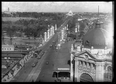
... The building of the bridge reflected the boom period of Melbourne, including the Victorian gold rush 1851- late 1860s, and its contractor, David Munro, was also responsible for the construction of Queens Bridge and Sandridge Railway Bridge. The Centenary pylons are no longer in place, but today this intersection still plays a major part in Melbourne’s daily life: people still meet “under the clocks” at Flinders Street station, and the route in and out of the city along St Kilda Road is often a feature of parades such as Moomba, the Grand Final Parade, and of course the Anzac Day Parade which commences at the Princes Bridge intersection and finishes at the Shrine of Remembrance. ...The building of the bridge reflected the boom period of Melbourne, including the Victorian gold rush 1851- late 1860s, and its contractor, David Munro, was also responsible for the construction of Queens Bridge and Sandridge Railway Bridge. The Centenary pylons are no longer in place, but today this intersection still plays a major part in Melbourne’s daily life: people still meet “under the clocks” at Flinders Street station, and the route in and out of the city along St Kilda Road is often a feature of parades such as Moomba, the Grand Final Parade, and of course the Anzac Day Parade which commences at the Princes Bridge intersection and finishes at the Shrine of Remembrance. ...Princes Bridge Centenary pylons under construction Possibly taken from Young and Jacksons Hotel (formerly Princes Bridge Hotel) on the corner of Flinders and Swanston streets, Flinders Street Station’s clocks and main entrance dominate, along with its distinctive copper dome and decorative façade. The time on the main clock is 1.40pm, and the sign underneath, reflecting Melbourne’s upcoming Centenary reads, “We must accommodate our Centenary visitors! Citizens! Do your share by taking paying guests.” At left is the original Princes Bridge Station, today the site of Federation Square. The riverside tram terminus advertises a Café/Tobacconist/Refreshment Room selling cigars & cigarettes, fountain drinks & confectionery, and in smaller text: “Leave your boot repairs here”. Nearly everyone is dressed in dark suits, coats and hats. The footpaths are wide and there are no traffic lights. The roadway stretches towards the Shrine of Remembrance, not yet dedicated but very dominant on the skyline. Government House is clearly visible across the wide parkland that would come to be known as Kings Domain and that is an area of deep importance to the people of the Eastern Kulin. Originally, Birrarung was part of a network of swamps and lagoons linked to the course of the river. From 1896, Public Works Department engineer Carlo Catani, oversaw a new channel to straighten the river and the swamps and lagoons were filled with spoil from the channel works. From the same vantage point today, only the top of the tower of Government House would be visible. The photo captures the pylons along Princes Bridge, mid-construction and being installed to mark Melbourne’s Centenary. The pylons were not without controversy. Both The Argus and The Age bemoaned them for being “made almost entirely of imported softwood timber”, denying work to native hardwood timber workers and sawmillers, and leading visitors to think Australia did not have its own exceptional native hardwoods. The pylons were also variously described in their incomplete state, as unimaginative and resembling an oilfield. Published: The Age 5 September 1934 Featured in "Newsworthy: Melbourne in photographs 1933-1936" exhibition at East Melbourne Library, October to December 2023. Exhibition caption by project volunteer, Louise McKenzie Photographer notations on slide: "Pylons + St Kilda Rd C57" Published: Age (Melbourne, Vic. : 1854 - 1954), Wednesday 5 September 1934, page 11 Published title: DECORATIONS -- THEN AND NOW. Published caption: "Although not completed yet, some impression of the effect of the decorations on Princes-bridge may be obtained from the first picture which shows the majestic sweep of St Kilda road with the Shrine of Remembrance and Government House dominating the horizon. The area to the left of St. Kilda-road and in front of Government House is portion of the area which it is proposed to call the King's Domain, which extends to Domain-road and Anderson-street..." Description: East-facing, elevated view of Flinders Street Station and Princes Bridge, featuring partially completed pylons erected for Melbourne's Centenary celebrations. The Shrine of Remembrance and Government House can be seen in the distance. In the foreground are trams, cars and trucks, pedestrians, Batman Avenue tram terminus and refreshment rooms. Signage on Flinders Street Station encourages citizens to accommodate Centenary visitors. The Melbourne Centenary was held 1934-35 in celebration John Batman's proclamation that Melbourne "the place for a village". Centenary events included a visit by Prince Henry, Duke of Gloucester. A Centenary Cake measuring 50 feet in height and ten tons in weight was cut into 250,000 pieces and sold at 1 shilling per piece for charity. Spectacular floodlighting of city landmarks, the creation of the Pioneer Women's Memorial Garden, and the MacRobertson Air Race from London, were other notable activities. Research by project volunteer, Louise McKenzie: The photo in The Age collage of 5 September 1934 has a slightly cropped foreground. The original photo has been taken from an elevated vantage point, most probably the roof of the Nicholas Building on the corner of Flinders and Swanston streets. The right foreground is dominated by the main “clocks” entrance to Flinders Street Station, showing its distinctive copper dome and decorative façade. The time on the main clock is 1.40 pm. The main sign on the front of the Station reads, "We Must Accommodate our Centenary Visitors! Citizens! Do your share by taking paying guests. Write to The Official Centenary Accommodation Bureau, 436 Collins St. City. Tel M 4671”. Another sign at eye level at the main entrance says: “Cheap Trips on Sundays”. The sign on the end of the roof along the eastern side of the station reads, “The Babies Need Your Help! Support Broadmeadows Foundling Hospital Appeal. July and August”. Run by the Sisters of St Joseph of the Sacred Heart, St Joseph’s Foundling Hospital was a purpose built infants’ home for up to 300 babies, plus accommodation for expectant mothers, mainly single women. In the early 1930s, the department (Victorian Children’s Welfare Department) contracted St Joseph’s Foundling Hospital to care for an additional 60 infant state wards, and up to 175 non wards at any given time. In 1931 it also operated a mothercraft training school. The centre foreground shows the commencement of Princes Bridge. Beneath the left side of the bridge was the site of the original Princes Bridge Station, by this time incorporated into Flinders Street Station, and today the area is the site of Federation Square. It was linked to Flinders Street station by the railway tracks that ran underneath the northern approach to the bridge. This photo shows a tram terminus which has a Café/Tobacconist/Refreshment Room, selling cigars & cigarettes, fountain drinks & confectionary, and a sign: Leave your boot repairs here. In the foreground is a wide roadway running south/north, comprising two vehicle lanes each heading north/south, and a central section containing two sets of tram tracks. There are cars, buses and delivery vans on the roadway. The trams visible are Glen Iris (Route No. 6; tram no. 448), Toorak (Route No. 8, tram no. 333), ? (No. 7), ? (No. 1), and ? (No. 2A). The footpaths are extremely wide. There is a square newspaper/magazine stand on the eastern side footpath. And also a “Ferry” sign. There are no traffic lights, but a policeman is visible on the roadway. There are pedestrians – men, women, children, a porter with trolley, women with prams. Clothing comprises dark suits, coats and hats for nearly everyone. There are double headed “Collins Street” lights along the side of the roadway, and along the northern riverbank. The roadway in the foreground is an extension of Swanston Street, which becomes Princes Bridge, then St Kilda Road, stretching towards the Shrine of Remembrance, and diverting past it. The Shrine had not yet been officially dedicated, and looks very white and dominant on the skyline. On the LHS of St Kilda Road, Government House is clearly visible across the wide parkland to be known as Kings Domain. The Kings Domain area is important to the people of the Eastern Kulin nation, and also has historical importance for its association with the early settlement of Melbourne and the foundation of British colonial administration in Victoria. On the southern side of the Yarra River (Birrarung) an historic rowing boathouse is visible, located adjacent to the Alexandra Gardens. Originally Birrarung was part of a network of swamps and lagoons linked to the course of the river. From 1896, under the guidance of engineer Carlo Catani* a new channel to straighten the river was created and the swamps and lagoons were filled with spoil from the channel works. The gardens were then created and completed in time for a Royal visit by the Duke of York in May 1901. The gardens are named after Alexandra of Denmark, the wife of King Edward VII. Both these areas, plus the Royal Botanic Gardens Victoria, Shrine of Remembrance Reserve, Sidney Myer Music Bowl, Government House, and the Queen Victoria Gardens together form the Domain Parklands. The extent of the subsequent plantings is evident today, where from the same vantage point only the top of the tower of Government House would be visible. *Catani was born in Florence in 1852, but after arriving in Melbourne worked as a civil engineer for the Victorian Government. His last major project was the reclamation of the foreshore of St Kilda, envisaged in the style of a European resort, complete with a split level esplanade, bathing pavilions, dance halls, amusements and a French-Italian style of landscape complete with palms. The gardens at the end of Fitzroy Street, St Kilda, now bear his name. The historic boathouse visible across the Yarra is another glimpse into Melbourne’s past. “Boathouse Row” comprises 7 amateur rowing clubs, the first established in 1859 (Melbourne University Boat Club). Other Clubs were Richmond, Melbourne, Banks, Melbourne Grammar School, Yarra Yarra and Mercantile. South of the river and west of the bridge is an area today developed into the Melbourne arts precinct of Hamer Hall and the Arts Centre. But at this time it was the home of Wirths Olympia Circus, which comprised Wirths Pleasure Park (an amusement park), a 5,000 seat auditorium – Hippodrome, a roller skating rink, a glaciarium, a cinema, and the Green Mill Dance Hall. Dog shows were also held at Olympia. The Green Mill Dance Hall closed in 1950, and the remainder of the Wirth buildings on site were destroyed by fire in December 1953. The feature of the photo is the pylons erected along Princes Bridge to mark Melbourne’s Centenary in 1934. The sixteen plastered pylons were designed by Roy Prentice, the second person to qualify as an architect at The University of Melbourne’s Bachelor of Architecture degree, in 1933, aged 27. Simon Reeves in his article marking the 100th birthday of Roy Prentice on 20 June 2006 reports that the State Electricity Commission sponsored this work, and the Argus reported that “… the pylons were “illuminated from within to give the effect of soft radiance”. Australia Home Beautiful 1 Oct 1934 reports in a very detailed and comprehensive article: The 10 taller pylons, including flagpole, were 48 ft, with a base of 8 ft. Timber-framed and faced with fibrous plaster and galvanised sheet iron, each structure was securely bolted to a concrete foundation three feet in depth. Panels of glass let into the shaft of each pylon were indirectly lit by 40, 100 watt lamps, and the upper bank of internal lamps were dyed so as to flood the panels with a deep red light. The decorative painted shields and flagpoles/pennants were illuminated by three 200 watt projectors concealed in the roof of each pylon, and were part of an electric night light decoration scheme involving 28 miles of wire to supply more than 20,000 lights. An article in the Argus on 18 October 1934 provided minute detail of the lighting erected in Melbourne for the Centenary, converting it “… into a coloured fairyland by night.” The estimated cost of 10 pounds per hour the lights were on. The display included 800 standard light poles 30 feet high which were tiered with electric bulbs concealed in inverted cones, 138 specially designed “Venetian poles” draped in flags trophies and streamers. The streets included in the electric night light decoration scheme were Bourke Street from Spring to William, the entire length of Collins Street, Flinders Street from Elizabeth to Spring, Lonsdale Street from Elizabeth to Swanston, Swanston and Elizabeth Streets from Flinders to Lonsdale, and parts of Springs and Spencer Streets. Together with the Princes Bridge pylons, approximately 28 miles of wire was required to supply power to the more than 20,000 lights. And that is just in the city of Melbourne. It was estimated the same amount of lighting was duplicated among other local councils. The pylons were not without controversy. The Argus on 28 August 1934 in an article headed “Imported Timber in Pylons” reported that the Princes Bridge pylons are “made almost entirely of imported softwood timber”, and have therefore denied work to native hardwood timber workers and sawmillers. The same day the Melbourne Age ran a similar story, bemoaning the fact that foreign oregon had been used which may lead tourists to think Australia did not have its own exceptional native hardwoods. A Camberwell City Councillor described the pylons as unimaginative, and the Herald reported that skeletons of pylons for the Centenary decorations in their present form led the area to resemble an oilfield! The Yarra River and Princes Bridge have long been a focal point of Melbourne life. In the early days of European settlement in Melbourne a rope-hauled punt carried people across the Yarra River. A surge in population and increased shipping traffic created a need for a bridge. There was difficulty in agreeing on a suitable site for the bridge (options were crossing at Elizabeth, Swanston, Queen or Market Streets), but the NSW Government favoured Swanston Street and the Melbourne Town Council decided on a temporary bridge across the Yarra spanning from the foot of Swanston Street. This first bridge was a single span timber toll bridge designed by Scottish born bridge designer David Lennox, and completed in 1845. It was 120 feet long, had a roadway of 17 feet wide, and a footpath on one side of 4 feet. It was leased to the Melbourne Bridge Company in the name of Robert A Balbirnie. The tollhouse was on the north side of the river and the toll keeper, Patrick Doherty, was credited with saving nine lives during the four years he was in charge of the toll station. The second bridge was stone (completed 1850), and named Prince’s Bridge after the HRH Prince of Wales, later Edward VII. It was designed with an elliptical single arc and an exceedingly small rise in proportion to the span. However, this design created an obstacle for flood waters, and together with Melbourne’s increasing population it was quickly apparent that a new bridge was required. At its opening on 15 November 1850 coincided with the imminent declaration of Victoria as a separate colony, it provided a moment of great celebration for Melbournians and “The opening ceremony was described as the grandest processional display witnessed in the colony.” (ToMelbourne.com.au) Princes Bridge in its present form, as depicted in this photograph, was designed by Jenkins, D’Ebro and Grainger, and constructed in 1886-88 by David Munro. John Grainger (father of Australian composer Percy Grainger) did the majority of the design work for the bridge. The structure was to have three arches each 96 feet wide measured across the river, and the banks on both sides were raised to allow more space for floodwater to flow. St Kilda Road was originally many feet below the current level. The bridge is of architectural significance for its substantial size, giant half columns, extensive use of wrought and cast iron, decorative elements (cast-iron lamps) and the skilled stonemasonry in the construction of the abutments and piers. Its main design features are similar to those of Blackfriars Bridge in London (1870). The bluestones were quarried from Footscray, the Malmsbury stones were from quarries at Kyneton, and the granite from Harcourt. The cost was met by the State of Victoria, City of Melbourne, and six out of seven of its municipalities, and their coats of arms feature on the bridge. The building of the bridge reflected the boom period of Melbourne, including the Victorian gold rush 1851- late 1860s, and its contractor, David Munro, was also responsible for the construction of Queens Bridge and Sandridge Railway Bridge. The Centenary pylons are no longer in place, but today this intersection still plays a major part in Melbourne’s daily life: people still meet “under the clocks” at Flinders Street station, and the route in and out of the city along St Kilda Road is often a feature of parades such as Moomba, the Grand Final Parade, and of course the Anzac Day Parade which commences at the Princes Bridge intersection and finishes at the Shrine of Remembrance. There are many tram routes, which cross the Bridge, and it directs pedestrians towards the Arts Precinct, the various components of Domain Park, plus the Southbank restaurant and rowing precincts. Even though this is a street scene, it feels very intimate; the viewer is instantly immersed in the activity of a Melbourne afternoon, looking down St Kilda Road from a viewpoint near today’s Federation Square. References: DECORATIONS -- THEN AND NOW. (1934, September 5). The Age (Melbourne, Vic. : 1854 - 1954), p. 11. Retrieved September 21, 2023, from http://nla.gov.au/nla.news-article205880269 'Flinders Street railway station', Wikipedia, https://en.wikipedia.org/wiki/Flinders_Street_railway_station 'St Joseph’s Foundling Hospital (1901-75)', Finding Records, Department of Health and Human Services, State of Victoria, https://www.findingrecords.dhhs.vic.gov.au/collectionresultspage/St-JosephsFoundling-Hospital-Babies-Home#departmental-administration 'Alexandra Gardens', City of Melbourne, https://www.melbourne.vic.gov.au/community/parks-open-spaces/major-parks-gardens/Pages/alexandra-gardens.aspx 'Wirths Circus', Wikipedia, https://en.wikipedia.org/wiki/Wirth's_Circus 'Roy Prentice: Centenary Architect', Built Heritage Pty Ltd, Simon Reeves, https://www.builtheritage.com.au/downloads/prentice.pdf 'Princes Bridge', Heritage Council Victoria, https://vhd.heritagecouncil.vic.gov.au/places/817 PORT PHILLIP. (1846, April 1). The Sydney Morning Herald (NSW : 1842 - 1954), p. 3. Retrieved September 21, 2023, from http://nla.gov.au/nla.news-article12886251 'Edward VII', Wikipedia, https://en.wikipedia.org/wiki/Edward_VII 'Princes Bridge', ToMelbourne.com, https://tomelbourne.com.au/princes-bridge/ 'Princes Bridge', eMelbourne, https://www.emelbourne.net.au/biogs/EM01189b.htm 'Princes Bridge', Australia for everyone, http://australiaforeveryone.com.au/files/melbourne/princes-bridge.html 'Victorian gold rush', Wikipedia, https://en.wikipedia.org/wiki/Victorian_gold_rush IMPORTED TIMBER IN PYLONS (1934, August 28). The Argus (Melbourne, Vic. : 1848 - 1957), p. 9. Retrieved September 21, 2023, from http://nla.gov.au/nla.news-article10952507 Princes-Bridge Pylons. (1934, August 28). The Age (Melbourne, Vic. : 1854 - 1954), p. 7. Retrieved September 21, 2023, from http://nla.gov.au/nla.news-article205532235 Pylons Appear Near Princes Bridge (1934, August 18). The Herald (Melbourne, Vic. : 1861 - 1954), p. 1. Retrieved September 21, 2023, from http://nla.gov.au/nla.news-article243104375 PRINCES-BRIDGE PYLONS. (1934, September 20). The Age (Melbourne, Vic. : 1854 - 1954), p. 10. Retrieved September 21, 2023, from http://nla.gov.au/nla.news-article205873535 28 Miles of Wire (1934, October 18). The Argus (Melbourne, Vic. : 1848 - 1957), p. 1 (The Junior Argus). Retrieved September 21, 2023, from http://nla.gov.au/nla.news-article10977836 'Historical references for Boathouse Row, Melbourne', http://boathouserowmelbourne.com.au/history/ 'ITALIAN DELEGATION TO HONOUR CARLO CATANI, DESIGNER OF THE ST KILDA FORESHORE, St Kilda Historical Society, 2001, https://web.archive.org/web/20070928061938/http://www.skhs.org.au/~SKHSarticles/articles/Carlo_Catani.html# HISTORY IN LIGHTS (1934, July 12). The Herald (Melbourne, Vic. : 1861 - 1954), p. 16. Retrieved September 21, 2023, from http://nla.gov.au/nla.news-article243172436 'Dressing Melbourne for the Duke', The Australian home beautiful: a journal for the home builder. Vol 12 No. 10 (1 October 1934), page 21, 58. Retrieved September 14, 2023, from http://nla.gov.au/nla.obj-2950922209Photographer notations on slide: "Pylons + St Kilda Rd C57".centenaries, bridges, lighting, flinders street railway station -
 Melbourne Tram Museum
Photograph - MMTB Traffic Congestion Spencer St. - set of 2, Melbourne & Metropolitan Tramways Board (MMTB), c1978
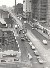
... The photo is dated by the construction of the MMBW building on the corner of Little Collins and Spencer St which took place between 1976 and 1979 - see reference. 1 - Looking north from Victorian Railways building on the corner of Collins and Spencer Sts - showing two trams (routes 41 and 74) with heavy northbound traffic, light southbound traffic. ...The photo is dated by the construction of the MMBW building on the corner of Little Collins and Spencer St which took place between 1976 and 1979 - see reference. 1 - Looking north from Victorian Railways building on the corner of Collins and Spencer Sts - showing two trams (routes 41 and 74) with heavy northbound traffic, light southbound traffic. ...Set of 2 photos showing traffic congestion in Spencer St during the late 1970s. See also items 9169, 4519 & 4520. The photo is dated by the construction of the MMBW building on the corner of Little Collins and Spencer St which took place between 1976 and 1979 - see reference. 1 - Looking north from Victorian Railways building on the corner of Collins and Spencer Sts - showing two trams (routes 41 and 74) with heavy northbound traffic, light southbound traffic. A policeman is on point duty. On the left is the Railways Parcels office and the main station building. In the far distance, the Sands McDougal building. On the right is The Age, the City of Melbourne power station chimney, Mail Exchange, a vacant building block which became the Savoy Tavern, the Savoy Plaza Hotel, the MMBW building under construction, and a row of single-storey shops, including one advertising Cadbury's Chocolates. 2 - View from the Victorian Railways Head Office building looking south at the intersection of Flinders Lane and Spencer St. The building on the left is the Great Southern Hotel. Since this photo, Flinders Lane has been widened and the car park built on. The northbound traffic has drifted over the solid white line and blocked four trams (routes 76, 47, & 74)Demonstrates the work of the MMTB in understanding traffic that affected trams.Black and white print - with MMTB Stamp on the rear.in ink "P2571/1037" on both photos.tramways, spencer st, traffic control, traffic -
 Sunshine and District Historical Society Incorporated
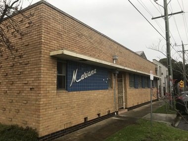
Photograph - Sunshine Photographs 2021 Part 4, John Alchin, 2021
... Place...Durham Road...Mariana Hall...R.T. Pollard Reserve...Railway...Pollard Reserve Sunshine 2021 Photo 01.JPG 5618.08 - Railway Bridge Forrest St Sunshine 2021 Photo 08.JPG 5618.09 - Ritchie Crt 2A Sunshine 2021 Photo 01.JPG 5618.10 - Road Bridge Kororoit Creek Sunshine 2021 Photo 02.JPG 5618.11 - Second Ave 14 Sunshine 2021 Photo 01.JPG 5618.12 - Second Ave 14 Sunshine 2021 Photo 03.JPG 5618.13 - Selwyn Park 2021 Photo 02.JPG 5618.14 - Selwyn Park 2021 Photo 04.JPG 5618.15 - Selwyn Park 2021 Photo 06.JPG 5618.16 - Service St 10 - Chus Hue Quang Temple 2021 Photo 01.JPG 5618.17 - Station Place 42 Sunshine 2021 Photo 01.JPG 5618.18 - Station Place 48 Sunshine - Early 20th Century House 2021 Photo 01.JPG 5618.19 - Station Place Sunshine 56 - 66 2021 Photo 01.JPG 5618.20 - Station Place Sunshine 2021 Photo 01.JPG 5618.21 - Stony Creek Sunshine 2021 Photo 01.JPG 5618.22 - Sun Cres 2A - 8A Sunshine 2021 Photo 01.JPG 5618.23 - Sun Cres 11 - 13 Sunshine 2021 Photo 01.JPG 5618.24 - Sun Cres 12 Sunshine (Former State Bank) 2021 Photo 01.JPG 5618.25 - Sun Cres 25 - 27 Sunshine 2021 Photo 01.JPG 5618.26 - Sun Cres 27 Rear - Self Service Grocer 2021 Photo 01.JPG 5618.27 - Sun Cres 29 Rear - U.F.S. ...Sunshine Monash Street Patterson Avenue Pizzey Street Forrest Street Second Avenue Service Street Station Place Sun Crescent City Place Durham Road Mariana Hall R.T. Pollard Reserve Railway Bridge Ritchie Court Selwyn Park Chus Hue Quang Temple Royal Antediluvian Order of Buffaloes Stony Creek Watt Street Sunshine Bus Exchange Sunshine Eldery Citizen's Club Sunshine Market Sunshine Municipal Offices Sunshine Ultimate Care Clinic 5618.01 - Monash St Sunshine - Mariana Hall 2021 Photo 01.JPG 5618.02 - Monash St Sunshine - Mariana Hall 2021 Photo 02.JPG 5618.03 - Parsons Reserve Sunshine 2021 Photo 01.JPG 5618.04 - Patterson Ave 14 - 16 Sunshine 2021 Photo 01.JPG 5618.05 - Pizzey St 12 Sunshine 2021 Photo 01.JPG 5618.06 - Pizzey St 12 Sunshine 2021 Photo 02.JPG 5618.07 - R.T. ...These photographs provide a visual record of assorted buildings, street views, and notable locations throughout Sunshine in 2021.This collection of photographs preserves a visual record of Sunshine 2021.5618.01 - Monash St Sunshine - Mariana Hall 2021 Photo 01.JPG 5618.02 - Monash St Sunshine - Mariana Hall 2021 Photo 02.JPG 5618.03 - Parsons Reserve Sunshine 2021 Photo 01.JPG 5618.04 - Patterson Ave 14 - 16 Sunshine 2021 Photo 01.JPG 5618.05 - Pizzey St 12 Sunshine 2021 Photo 01.JPG 5618.06 - Pizzey St 12 Sunshine 2021 Photo 02.JPG 5618.07 - R.T. Pollard Reserve Sunshine 2021 Photo 01.JPG 5618.08 - Railway Bridge Forrest St Sunshine 2021 Photo 08.JPG 5618.09 - Ritchie Crt 2A Sunshine 2021 Photo 01.JPG 5618.10 - Road Bridge Kororoit Creek Sunshine 2021 Photo 02.JPG 5618.11 - Second Ave 14 Sunshine 2021 Photo 01.JPG 5618.12 - Second Ave 14 Sunshine 2021 Photo 03.JPG 5618.13 - Selwyn Park 2021 Photo 02.JPG 5618.14 - Selwyn Park 2021 Photo 04.JPG 5618.15 - Selwyn Park 2021 Photo 06.JPG 5618.16 - Service St 10 - Chus Hue Quang Temple 2021 Photo 01.JPG 5618.17 - Station Place 42 Sunshine 2021 Photo 01.JPG 5618.18 - Station Place 48 Sunshine - Early 20th Century House 2021 Photo 01.JPG 5618.19 - Station Place Sunshine 56 - 66 2021 Photo 01.JPG 5618.20 - Station Place Sunshine 2021 Photo 01.JPG 5618.21 - Stony Creek Sunshine 2021 Photo 01.JPG 5618.22 - Sun Cres 2A - 8A Sunshine 2021 Photo 01.JPG 5618.23 - Sun Cres 11 - 13 Sunshine 2021 Photo 01.JPG 5618.24 - Sun Cres 12 Sunshine (Former State Bank) 2021 Photo 01.JPG 5618.25 - Sun Cres 25 - 27 Sunshine 2021 Photo 01.JPG 5618.26 - Sun Cres 27 Rear - Self Service Grocer 2021 Photo 01.JPG 5618.27 - Sun Cres 29 Rear - U.F.S. Dispensary 2021 Photo 01.JPG 5618.28 - Sun Cres 29A - Royal Antediluvian Order of Buffaloes (R.A.O.B.) 2021 Photo 01.JPG 5618.29 - Sun Cres 29A - Royal Antediluvian Order of Buffaloes (R.A.O.B.) 2021 Photo 02.JPG 5618.30 - Sun Cres 29A - Royal Antediluvian Order of Buffaloes (R.A.O.B.) 2021 Photo 05.JPG 5618.31 - Sun Cres 2021 Photo 01.JPG 5618.32 - Sun Crescent 31A Lane to 22-Watt St Sunshine 2021 Photo 01.JPG 5618.33 - Sun Cres 47 Sunshine - Former Miss Alma Pattinson Private Hospital 2021 Photo 01.JPG 5618.34 - Sunshine Corner of Durham Rd and City Place Sunshine 2021 Photo 01.JPG 5618.35 - Sunshine Bus Exchange Station Place Sunshine 2021 Photo 01.JPG 5618.36 - Sunshine Bus Interchange 2021 Photo 01.JPG 5618.37 - Sunshine Elderly Citizens Club Sign 2021 Photo 01.JPG 5618.38 - Sunshine Market City Place 2021 Photo 01.JPG 5618.39 - Sunshine Municipal Offices 2021 Photo 02.JPG 5618.40 - Sunshine Ultimate Care Clinic 127 Durham Rd Sunshine 2021 Photo 01.JPG 5618.41 - Station Place 40 And 42 Sunshine 2021 Photo 01.JPG sunshine, monash street, patterson avenue, pizzey street, forrest street, second avenue, service street, station place, sun crescent, city place, durham road, mariana hall, r.t. pollard reserve, railway bridge, ritchie court, selwyn park, chus hue quang temple, royal antediluvian order of buffaloes, stony creek, watt street, sunshine bus exchange, sunshine eldery citizen's club, sunshine market, sunshine municipal offices, sunshine ultimate care clinic -
 Sunshine and District Historical Society Incorporated
Photograph - Sunshine Photographs 2021 Part 5, John Alchin, 2021
... Railway Station...Sunshine Primary School...Sunshine RSL...Derby Road...Sunshine Secondary College...Sunshine Swimming Pool...Sunshine Uniting Church...Sunshine Wesleyan Methodist Church...Salvation Army...Visy Cares Hub...Tobin Brothers...Voice of Christ Full Gospel...Sunshine Meeting Place...Sunshine Watt Street Corio Street Wright Street Devonshire Road Sunshine Harvester Primary School Sunshine Railway Station Sunshine Primary School Sunshine RSL Derby Road Sunshine Secondary College Sunshine Swimming Pool Sunshine Uniting Church Sunshine Wesleyan Methodist Church Salvation Army Visy Cares Hub Tobin Brothers Voice of Christ Full Gospel Sunshine Meeting Place Massey Ferguson 5619.01 - Sunshine Harvester Primary School 2021 Photo 02.JPG 5619.02 - Sunshine Harvester Primary School 2021 Photo 04.JPG 5619.03 - Sunshine Harvester Primary School 2021 Photo 05.JPG 5619.04 - Sunshine Harvester Primary School 2021 Photo 03.JPG 5619.05 - Sunshine Harvester Primary School 2021 Photo 07.JPG 5619.06 - Sunshine Primary School 2021 Photo 01.JPG 5619.07 - Sunshine Primary School Hampshire Rd Sunshine 2021 Photo 01.JPG 5619.08 - Sunshine Railway Station 2021 Photo 01.JPG 5619.09 - Sunshine Railway Station Indigenous Vegetation Sign 2021 Photo 01.JPG 5619.10 - Sunshine RSL 2021 Photo 02.JPG 5619.11 - Sunshine RSL 2021 Photo 01.JPG 5619.12 - Sunshine RSL 2021 Photo 04.JPG 5619.13 - Sunshine RSL 2021 Photo 06.JPG 5619.14 - Sunshine RSL 2021 Photo 07.JPG 5619.15 - Sunshine Secondary College 2021 Photo 10.JPG 5619.16 - Sunshine Secondary College 2021 Photo 14.JPG 5619.17 - Sunshine Secondary College 2021 Photo 17.JPG 5619.18 - Sunshine Swimming Pool 2021 Photo 01.JPG 5619.19 - Sunshine Swimming Pool 2021 Photo 02.JPG 5619.20 - Sunshine Uniting Church Devonshire Rd 2021 Photo 01.JPG 5619.21 - Sunshine Wesleyan Methodist Church Monash St Sunshine 2021 Photo 01.JPG 5619.22 - Sunvale Comunity Park 2021 Photo 01.JPG 5619.23 - Tennis Courts 115A Devonshire Rd Sunshine 2021 Photo 01.JPG 5619.24 - Tennis Courts 115A Devonshire Rd Sunshine 2021 Photo 02.JPG 5619.25 - The Salvation Army Devonshire Rd Cnr Martin St Sunshine 2021 Photo 01.JPG 5619.26 - Tobin Brothers Hampshire Rd Sunshine 2021 Photo 01.JPG 5619.27 - Visy Cares Hub Sunshine 2021 Photo 01.JPG 5619.28 - Watt St 14 - 16A Sunshine 2021 Photo 01.JPG 5619.29 - Voice of Christ Full Gospel Church Corio St Sunshine 2021 Photo 01.JPG 5619.30 - Watt St 22 Dentist 2021 Photo 01.JPG 5619.31 - Watt St 22 Dentist 2021 Photo 03.JPG 5619.32 - Watt St 22 Sunshine - Dentist 2021 Photo 01.JPG 5619.33 - Watt St 22 Sunshine - Dentist 2021 Photo 02.JPG 5619.34 - Wilkinson St 29 - Sunshine Meeting Place 2021 Photo 02.JPG 5619.35 - Wright St 66 Sunshine 2021 Photo 01.JPG 5619.36 - Wright St 91 Sunshine - Former Shop 2021 Photo 01.JPG 5619.37 - Massey Ferguson Devonshire Rd 2021 Photo 05.JPG 5619.38 - Massey Ferguson Devonshire Rd 2021 Photo 08.JPG 5619.39 - Massey Ferguson Devonshire Rd 2021 Photo 11.JPG 5619.40 - Massey Ferguson Devonshire Rd 2021 Photo 10.JPG 5619.41 - Massey Ferguson Devonshire Rd 2021 Photo 13.JPG 5619.42 - Massey Ferguson Devonshire Rd 2021 Photo 14.JPG 5619.43 - Massey Ferguson Devonshire Rd 2021 Photo 15.JPG 5619.44 - Massey Ferguson Devonshire Rd 2021 Photo 16.JPG 5619.45 - Massey Ferguson Devonshire Rd 2021 Photo 17.JPG Large collection of digital photographs that have be split over five identification numbers. ...These photographs provide a visual record of assorted buildings, street views, and notable locations throughout Sunshine in 2021.This collection of photographs preserves a visual record of Sunshine 2021.5619.01 - Sunshine Harvester Primary School 2021 Photo 02.JPG 5619.02 - Sunshine Harvester Primary School 2021 Photo 04.JPG 5619.03 - Sunshine Harvester Primary School 2021 Photo 05.JPG 5619.04 - Sunshine Harvester Primary School 2021 Photo 03.JPG 5619.05 - Sunshine Harvester Primary School 2021 Photo 07.JPG 5619.06 - Sunshine Primary School 2021 Photo 01.JPG 5619.07 - Sunshine Primary School Hampshire Rd Sunshine 2021 Photo 01.JPG 5619.08 - Sunshine Railway Station 2021 Photo 01.JPG 5619.09 - Sunshine Railway Station Indigenous Vegetation Sign 2021 Photo 01.JPG 5619.10 - Sunshine RSL 2021 Photo 02.JPG 5619.11 - Sunshine RSL 2021 Photo 01.JPG 5619.12 - Sunshine RSL 2021 Photo 04.JPG 5619.13 - Sunshine RSL 2021 Photo 06.JPG 5619.14 - Sunshine RSL 2021 Photo 07.JPG 5619.15 - Sunshine Secondary College 2021 Photo 10.JPG 5619.16 - Sunshine Secondary College 2021 Photo 14.JPG 5619.17 - Sunshine Secondary College 2021 Photo 17.JPG 5619.18 - Sunshine Swimming Pool 2021 Photo 01.JPG 5619.19 - Sunshine Swimming Pool 2021 Photo 02.JPG 5619.20 - Sunshine Uniting Church Devonshire Rd 2021 Photo 01.JPG 5619.21 - Sunshine Wesleyan Methodist Church Monash St Sunshine 2021 Photo 01.JPG 5619.22 - Sunvale Comunity Park 2021 Photo 01.JPG 5619.23 - Tennis Courts 115A Devonshire Rd Sunshine 2021 Photo 01.JPG 5619.24 - Tennis Courts 115A Devonshire Rd Sunshine 2021 Photo 02.JPG 5619.25 - The Salvation Army Devonshire Rd Cnr Martin St Sunshine 2021 Photo 01.JPG 5619.26 - Tobin Brothers Hampshire Rd Sunshine 2021 Photo 01.JPG 5619.27 - Visy Cares Hub Sunshine 2021 Photo 01.JPG 5619.28 - Watt St 14 - 16A Sunshine 2021 Photo 01.JPG 5619.29 - Voice of Christ Full Gospel Church Corio St Sunshine 2021 Photo 01.JPG 5619.30 - Watt St 22 Dentist 2021 Photo 01.JPG 5619.31 - Watt St 22 Dentist 2021 Photo 03.JPG 5619.32 - Watt St 22 Sunshine - Dentist 2021 Photo 01.JPG 5619.33 - Watt St 22 Sunshine - Dentist 2021 Photo 02.JPG 5619.34 - Wilkinson St 29 - Sunshine Meeting Place 2021 Photo 02.JPG 5619.35 - Wright St 66 Sunshine 2021 Photo 01.JPG 5619.36 - Wright St 91 Sunshine - Former Shop 2021 Photo 01.JPG 5619.37 - Massey Ferguson Devonshire Rd 2021 Photo 05.JPG 5619.38 - Massey Ferguson Devonshire Rd 2021 Photo 08.JPG 5619.39 - Massey Ferguson Devonshire Rd 2021 Photo 11.JPG 5619.40 - Massey Ferguson Devonshire Rd 2021 Photo 10.JPG 5619.41 - Massey Ferguson Devonshire Rd 2021 Photo 13.JPG 5619.42 - Massey Ferguson Devonshire Rd 2021 Photo 14.JPG 5619.43 - Massey Ferguson Devonshire Rd 2021 Photo 15.JPG 5619.44 - Massey Ferguson Devonshire Rd 2021 Photo 16.JPG 5619.45 - Massey Ferguson Devonshire Rd 2021 Photo 17.JPG sunshine, watt street, corio street, wright street, devonshire road, sunshine harvester primary school, sunshine railway station, sunshine primary school, sunshine rsl, derby road, sunshine secondary college, sunshine swimming pool, sunshine uniting church, sunshine wesleyan methodist church, salvation army, visy cares hub, tobin brothers, voice of christ full gospel, sunshine meeting place, massey ferguson -
 Sunshine and District Historical Society Incorporated
Photograph - Sunshine Photographs 2022 Part 1, John Alchin, 2022
... 5627.01 - Alexandra Ave Sunshine - Sunshine Muncipal Offices 2022 Photo 01.JPG 5627.02 - Alexandra Ave Sunshine - Sunshine Muncipal Offices 2022 Photo 02.JPG 5627.03 - Alexandra Ave Sunshine - Sunshine Muncipal Offices 2022 Photo 05.JPG 5627.04 - Anderson Rd - Sunshine Vietnamese Baptist Church.JPG 5627.05 - Anderson Rd 79 - Andy's Service Station Sign 2022 Photo 02.JPG 5627.06 - Anderson Rd 79 Sunshine - Andy's Service Station Sign 2022 Photo 01.JPG 5627.07 - Anderson Rd 126 Sunshine - Sunhine Presbyterian Church Manse 2022 Photo 01.JPG 5627.08 - Andersons Rd 101 - 103 Sunshine 2022 Photo 01.JPG 5627.09 - Ballarat Rd 503 Sunshine - StoreLocal 2022 Photo 01.JPG 5627.10 - Ballarat Rd 505 Sunshine - Former AMF Ten Pin Bowling Centre 2022.JPG 5627.11 - Ballarat Rd 505 Sunshine - Melbourne Airport Rail Construction Support Facility Sign 2022 Photo 02.JPG 5627.12 - Ballarat Service Rd Sunshine - Stony Creek Culvert 2022 Photo 01.JPG 5627.13 - City Place 2 -4 Sunshine 2022 Photo 01.JPG 5627.14 - City Place 8 - 12 Sunshine 2022 Photo 01.JPG 5627.15 - City Place 22 Sunshine 2022 Photo 01.JPG 5627.16 - City Place 24 Sunshine 2022 Photo 01.JPG 5627.17 - City Place Sunshine - Reflexio Qualis 2022 Photo 02.JPG 5627.18 - Clarke St 6 Sunshine 2022 Photo 01.JPG 5627.19 - Derby Rd Sunshine - Kororoit Creek Bridge 2022 Photo 02.JPG 5627.20 - Derby St 105 Sunshine 2022 Photo 01.JPG 5627.21 - Devonshire Rd 5 Sunshine 2020 Photo 01.JPG 5627.22 - Dickson St 9 - 15 Sunshine 2022 Photo 01.JPG 5627.23 - Dickson St Sunshine - Reflexio Qualis 2022 Photo 02.JPG 5627.24 - Durham Rd 113 Sunshine 2022 Photo 01.JPG 5627.25 - Durham St 115 Sunshine - Former Bank 2022 Photo 01.JPG 5627.26 - Forrest St Railway Bridge Kororoit Creek 2022 Photo 01.JPG 5627.27 - Fraser St 75 Sunshine - Wilfred Clayton's House 2022 Photo 01.JPG 5627.28 - Fraser St Sunshine - Legenda's Garden 2022 Photo 01.JPG 5627.29 - Fraser St Sunshine - Legenda's Garden 2022 Photo 04.JPG 5627.30 - H.V. ...McKay Memorial Gardens Sunshine Pedestrian Bridge Hampshire Road 5627.01 - Alexandra Ave Sunshine - Sunshine Muncipal Offices 2022 Photo 01.JPG 5627.02 - Alexandra Ave Sunshine - Sunshine Muncipal Offices 2022 Photo 02.JPG 5627.03 - Alexandra Ave Sunshine - Sunshine Muncipal Offices 2022 Photo 05.JPG 5627.04 - Anderson Rd - Sunshine Vietnamese Baptist Church.JPG 5627.05 - Anderson Rd 79 - Andy's Service Station Sign 2022 Photo 02.JPG 5627.06 - Anderson Rd 79 Sunshine - Andy's Service Station Sign 2022 Photo 01.JPG 5627.07 - Anderson Rd 126 Sunshine - Sunhine Presbyterian Church Manse 2022 Photo 01.JPG 5627.08 - Andersons Rd 101 - 103 Sunshine 2022 Photo 01.JPG 5627.09 - Ballarat Rd 503 Sunshine - StoreLocal 2022 Photo 01.JPG 5627.10 - Ballarat Rd 505 Sunshine - Former AMF Ten Pin Bowling Centre 2022.JPG 5627.11 - Ballarat Rd 505 Sunshine - Melbourne Airport Rail Construction Support Facility Sign 2022 Photo 02.JPG 5627.12 - Ballarat Service Rd Sunshine - Stony Creek Culvert 2022 Photo 01.JPG 5627.13 - City Place 2 -4 Sunshine 2022 Photo 01.JPG 5627.14 - City Place 8 - 12 Sunshine 2022 Photo 01.JPG 5627.15 - City Place 22 Sunshine 2022 Photo 01.JPG 5627.16 - City Place 24 Sunshine 2022 Photo 01.JPG 5627.17 - City Place Sunshine - Reflexio Qualis 2022 Photo 02.JPG 5627.18 - Clarke St 6 Sunshine 2022 Photo 01.JPG 5627.19 - Derby Rd Sunshine - Kororoit Creek Bridge 2022 Photo 02.JPG 5627.20 - Derby St 105 Sunshine 2022 Photo 01.JPG 5627.21 - Devonshire Rd 5 Sunshine 2020 Photo 01.JPG 5627.22 - Dickson St 9 - 15 Sunshine 2022 Photo 01.JPG 5627.23 - Dickson St Sunshine - Reflexio Qualis 2022 Photo 02.JPG 5627.24 - Durham Rd 113 Sunshine 2022 Photo 01.JPG 5627.25 - Durham St 115 Sunshine - Former Bank 2022 Photo 01.JPG 5627.26 - Forrest St Railway Bridge Kororoit Creek 2022 Photo 01.JPG 5627.27 - Fraser St 75 Sunshine - Wilfred Clayton's House 2022 Photo 01.JPG 5627.28 - Fraser St Sunshine - Legenda's Garden 2022 Photo 01.JPG 5627.29 - Fraser St Sunshine - Legenda's Garden 2022 Photo 04.JPG 5627.30 - H.V. ...These photographs provide a visual record of assorted buildings, street views, and notable locations throughout Sunshine in 2022.This collection of photographs preserves a visual record of Sunshine 2022.5627.01 - Alexandra Ave Sunshine - Sunshine Muncipal Offices 2022 Photo 01.JPG 5627.02 - Alexandra Ave Sunshine - Sunshine Muncipal Offices 2022 Photo 02.JPG 5627.03 - Alexandra Ave Sunshine - Sunshine Muncipal Offices 2022 Photo 05.JPG 5627.04 - Anderson Rd - Sunshine Vietnamese Baptist Church.JPG 5627.05 - Anderson Rd 79 - Andy's Service Station Sign 2022 Photo 02.JPG 5627.06 - Anderson Rd 79 Sunshine - Andy's Service Station Sign 2022 Photo 01.JPG 5627.07 - Anderson Rd 126 Sunshine - Sunhine Presbyterian Church Manse 2022 Photo 01.JPG 5627.08 - Andersons Rd 101 - 103 Sunshine 2022 Photo 01.JPG 5627.09 - Ballarat Rd 503 Sunshine - StoreLocal 2022 Photo 01.JPG 5627.10 - Ballarat Rd 505 Sunshine - Former AMF Ten Pin Bowling Centre 2022.JPG 5627.11 - Ballarat Rd 505 Sunshine - Melbourne Airport Rail Construction Support Facility Sign 2022 Photo 02.JPG 5627.12 - Ballarat Service Rd Sunshine - Stony Creek Culvert 2022 Photo 01.JPG 5627.13 - City Place 2 -4 Sunshine 2022 Photo 01.JPG 5627.14 - City Place 8 - 12 Sunshine 2022 Photo 01.JPG 5627.15 - City Place 22 Sunshine 2022 Photo 01.JPG 5627.16 - City Place 24 Sunshine 2022 Photo 01.JPG 5627.17 - City Place Sunshine - Reflexio Qualis 2022 Photo 02.JPG 5627.18 - Clarke St 6 Sunshine 2022 Photo 01.JPG 5627.19 - Derby Rd Sunshine - Kororoit Creek Bridge 2022 Photo 02.JPG 5627.20 - Derby St 105 Sunshine 2022 Photo 01.JPG 5627.21 - Devonshire Rd 5 Sunshine 2020 Photo 01.JPG 5627.22 - Dickson St 9 - 15 Sunshine 2022 Photo 01.JPG 5627.23 - Dickson St Sunshine - Reflexio Qualis 2022 Photo 02.JPG 5627.24 - Durham Rd 113 Sunshine 2022 Photo 01.JPG 5627.25 - Durham St 115 Sunshine - Former Bank 2022 Photo 01.JPG 5627.26 - Forrest St Railway Bridge Kororoit Creek 2022 Photo 01.JPG 5627.27 - Fraser St 75 Sunshine - Wilfred Clayton's House 2022 Photo 01.JPG 5627.28 - Fraser St Sunshine - Legenda's Garden 2022 Photo 01.JPG 5627.29 - Fraser St Sunshine - Legenda's Garden 2022 Photo 04.JPG 5627.30 - H.V. McKay Memorial Gardens 2022 Photo 02.JPG 5627.31 - H.V. McKay Memorial Gardens 2022 Photo 03.JPG 5627.32 - H.V. McKay Memorial Gardens 2022 Photo 04.JPG 5627.33 - H.V. McKay Pedestrian Bridge 2022 Photo 01.JPG 5627.34 - Hampshire Rd 36 Sunshine 2022 Photo 01.JPG 5627.35 - Hampshire Rd 42 Sunshine 2022 Photo 01.JPG 5627.36 - Hampshire Rd 44 Sunshine 2022 Photo 01.JPG 5627.37 - Hampshire Rd 68 - 70 Sunshine 2022 Photo 01.JPG 5627.38 - Hampshire Rd 74 - 76 Sunshine - Shops 2022 Photo 01.JPG 5627.39 - Hampshire Rd 74 - 76 Sunshine 2022 Photo 01.JPG 5627.40 - Hampshire Rd 74 - 76 Sunshine 2022 Photo 02.JPG 5627.41 - Hampshire Rd 74 - 76 Sunshine 2022 Photo 04.JPG 5627.42 - Hampshire Rd 86 - 88 Sunshine - Shops 2022 Photo 02.JPG sunshine municipal offices, alexandra avenue, sunshine, sunshine presbyterian church, anderson road, andy's service station, service station, sunshine presbyterian church manse, hot springs spa, storelocal, ten pin bowling centre, ballarat road service road, stony creek, stony creek drain, sun crescent, city place, reflexio qualis, clarke street, derby road bridge, derby road, devonshire road, dickson street, durham road, glengala road bridge, fraser street, legenda's garden, h.v. mckay memorial gardens, sunshine pedestrian bridge, hampshire road -
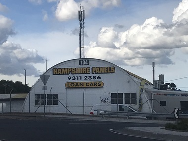 Sunshine and District Historical Society Incorporated
Photograph - Sunshine Photographs 2022 Part 2, John Alchin, 2022
... 5628.01 - Hampshire Rd 134 - Sunshine Panels 2022 Photo 01.JPG 5628.02 - Hampshire Rd 221A Sunshine - NNB Dessert House 2022 Photo 01.JPG 5628.03 - Hampshire Rd 234 - 246 Sunshine 2022 Photo 01.JPG 5628.04 - Hampshire Rd 254 2022 Sunshine Photo 01.JPG 5628.05 - Hampshire Rd 277 (Rear) Sunshine - Ruby's Club 2022 Photo 01.JPG 5628.06 - Hampshire Rd 324 - 328 Sunshine - Sunshine Plaza 2022 Photo 01.JPG 5628.07 - Hampshire Rd Sunshine Looking North from Railway Line 2022 Photo 01.JPG 5628.08 - Hampshire Rd Sunshine S-E Cnr Devonshire Rd 2022 Photo 01.JPG 5628.09 - Hampshire Rd Sunshine - Sunshine Primary School 2022 Photo 01.JPG 5628.10 - Sunshine Rifle Club Site Kororoit Creek Ford between the Shooting And Target Butts 2022 Photo 01.JPG 5628.11 - Sunshine Rifle Club Site Kororoit Creek Approx Site of Former Sunshine Rifle Range Target Butt Site 2022 Photo 01.JPG 5628.12 - Sunshine Rifle Club Site Kororoit Creek Approx Site of Former Sunshine Rifle Range Target Butt Site 2022 Photo 02.JPG 5628.13 - Kororoit Creek Fraser St Stony Creek Outlet 2022 Photo 01.JPG 5628.14 - Market Rd 6 Sunshine 2022 Photo 01.JPG 5628.15 - Market Rd 6 Sunshine 2022 Photo 02.JPG 5628.16 - Market Rd Sunshine 16 2022 Photo 01.JPG 5628.17 - McIntyre Rd Looking Toward Bendigo Railway Line Underpass 2022 Photo 01.JPG 5628.18 - McKay's Pedestrian Bridge 2022 Photo 01.JPG 5628.19 - Ormond Ave 31 Sunshine - United Pumps 2022 Photo 01.JPG 5628.20 - Second Ave 12 Sunshine 2022 Photo 02.JPG 5628.22 - Second Ave 23 - 25 Sunshine - Former Cabinet Works 2022 Photo 01.JPG 5628.21 - Man Lifting Cow Hampshire Rd 2020 Photo 01.JPG 5628.23 - Service St 5 Sunshine 2022 Photo 01.JPG 5628.24 - Service St 15 - 19 Sunshine - Building Under Construction 2022 Photo 01.JPG 5628.25 - St. Albans Rd Sunshine North - Former Albion Station Site (1859 - 1861) 2022 Photo 04.JPG 5628.26 - Station Place...Albans Road Sun Crescent Sunshine North 5628.01 - Hampshire Rd 134 - Sunshine Panels 2022 Photo 01.JPG 5628.02 - Hampshire Rd 221A Sunshine - NNB Dessert House 2022 Photo 01.JPG 5628.03 - Hampshire Rd 234 - 246 Sunshine 2022 Photo 01.JPG 5628.04 - Hampshire Rd 254 2022 Sunshine Photo 01.JPG 5628.05 - Hampshire Rd 277 (Rear) Sunshine - Ruby's Club 2022 Photo 01.JPG 5628.06 - Hampshire Rd 324 - 328 Sunshine - Sunshine Plaza 2022 Photo 01.JPG 5628.07 - Hampshire Rd Sunshine Looking North from Railway Line 2022 Photo 01.JPG 5628.08 - Hampshire Rd Sunshine S-E Cnr Devonshire Rd 2022 Photo 01.JPG 5628.09 - Hampshire Rd Sunshine - Sunshine Primary School 2022 Photo 01.JPG 5628.10 - Sunshine Rifle Club Site Kororoit Creek Ford between the Shooting And Target Butts 2022 Photo 01.JPG 5628.11 - Sunshine Rifle Club Site Kororoit Creek Approx Site of Former Sunshine Rifle Range Target Butt Site 2022 Photo 01.JPG 5628.12 - Sunshine Rifle Club Site Kororoit Creek Approx Site of Former Sunshine Rifle Range Target Butt Site 2022 Photo 02.JPG 5628.13 - Kororoit Creek Fraser St Stony Creek Outlet 2022 Photo 01.JPG 5628.14 - Market Rd 6 Sunshine 2022 Photo 01.JPG 5628.15 - Market Rd 6 Sunshine 2022 Photo 02.JPG 5628.16 - Market Rd Sunshine 16 2022 Photo 01.JPG 5628.17 - McIntyre Rd Looking Toward Bendigo Railway Line Underpass 2022 Photo 01.JPG 5628.18 - McKay's Pedestrian Bridge 2022 Photo 01.JPG 5628.19 - Ormond Ave 31 Sunshine - United Pumps 2022 Photo 01.JPG 5628.20 - Second Ave 12 Sunshine 2022 Photo 02.JPG 5628.22 - Second Ave 23 - 25 Sunshine - Former Cabinet Works 2022 Photo 01.JPG 5628.21 - Man Lifting Cow Hampshire Rd 2020 Photo 01.JPG 5628.23 - Service St 5 Sunshine 2022 Photo 01.JPG 5628.24 - Service St 15 - 19 Sunshine - Building Under Construction 2022 Photo 01.JPG 5628.25 - St. Albans Rd Sunshine North - Former Albion Station Site (1859 - 1861) 2022 Photo 04.JPG 5628.26 - Station Place ...These photographs provide a visual record of assorted buildings, street views, and notable locations throughout Sunshine in 2022.This collection of photographs preserves a visual record of Sunshine 2022.5628.01 - Hampshire Rd 134 - Sunshine Panels 2022 Photo 01.JPG 5628.02 - Hampshire Rd 221A Sunshine - NNB Dessert House 2022 Photo 01.JPG 5628.03 - Hampshire Rd 234 - 246 Sunshine 2022 Photo 01.JPG 5628.04 - Hampshire Rd 254 2022 Sunshine Photo 01.JPG 5628.05 - Hampshire Rd 277 (Rear) Sunshine - Ruby's Club 2022 Photo 01.JPG 5628.06 - Hampshire Rd 324 - 328 Sunshine - Sunshine Plaza 2022 Photo 01.JPG 5628.07 - Hampshire Rd Sunshine Looking North from Railway Line 2022 Photo 01.JPG 5628.08 - Hampshire Rd Sunshine S-E Cnr Devonshire Rd 2022 Photo 01.JPG 5628.09 - Hampshire Rd Sunshine - Sunshine Primary School 2022 Photo 01.JPG 5628.10 - Sunshine Rifle Club Site Kororoit Creek Ford between the Shooting And Target Butts 2022 Photo 01.JPG 5628.11 - Sunshine Rifle Club Site Kororoit Creek Approx Site of Former Sunshine Rifle Range Target Butt Site 2022 Photo 01.JPG 5628.12 - Sunshine Rifle Club Site Kororoit Creek Approx Site of Former Sunshine Rifle Range Target Butt Site 2022 Photo 02.JPG 5628.13 - Kororoit Creek Fraser St Stony Creek Outlet 2022 Photo 01.JPG 5628.14 - Market Rd 6 Sunshine 2022 Photo 01.JPG 5628.15 - Market Rd 6 Sunshine 2022 Photo 02.JPG 5628.16 - Market Rd Sunshine 16 2022 Photo 01.JPG 5628.17 - McIntyre Rd Looking Toward Bendigo Railway Line Underpass 2022 Photo 01.JPG 5628.18 - McKay's Pedestrian Bridge 2022 Photo 01.JPG 5628.19 - Ormond Ave 31 Sunshine - United Pumps 2022 Photo 01.JPG 5628.20 - Second Ave 12 Sunshine 2022 Photo 02.JPG 5628.22 - Second Ave 23 - 25 Sunshine - Former Cabinet Works 2022 Photo 01.JPG 5628.21 - Man Lifting Cow Hampshire Rd 2020 Photo 01.JPG 5628.23 - Service St 5 Sunshine 2022 Photo 01.JPG 5628.24 - Service St 15 - 19 Sunshine - Building Under Construction 2022 Photo 01.JPG 5628.25 - St. Albans Rd Sunshine North - Former Albion Station Site (1859 - 1861) 2022 Photo 04.JPG 5628.26 - Station Place 66 Sunshine 2022 Photo 01.JPG 5628.27 - Sun Cres 5 - 7 Sunshine 2022 Photo 01.JPG 5628.28 - Sun Cres 5 - 9 Sunshine 2022 Photo 01.JPG 5628.29 - Sun Cres 9 Sunshine 2022 Photo 01.JPG 5628.30 - Sun Cres 11 - 17 Sunshine 2022 Photo 01.JPG 5628.31 - Sun Cres 15 - 21 Sunshine 2022 Photo 01.JPG 5628.32 - Sun Cres 29 Sunshine - Sun Cres Medical Centre 2022 Photo 01.JPG 5628.33 - Sun Cres 33 Sunshine 2022 Photo 01 (2).JPG 5628.34 - Sun Cres 33 Sunshine 2022 Photo 01.JPG 5628.35 - Sun Cres 202 Sunshine Photo 01.JPG 5628.36 - Sun Cres 2022 Sunshine Photo 02.JPG 5628.37 - Sun Cres 2022 Sunshine Photo 08.JPG 5628.38 - Sun Cres And Durham Rd Sunshine Intersection Looking South 2022 Photo 01.JPG 5628.39 - Sun Cres Sunshine 2022 Photo 03.JPG 5628.40 - Sun Cres Sunshine 2022 Photo 05.JPG 5628.41 - Sun Cres Sunshine 2022 Photo 06.JPG 5628.42 - Sun Cres Sunshine 2022 Photo 07.JPG 5628.43 - Sun Cres Sunshine 2022 Photo 09.JPG 5628.44 - Sun Cres Sunshine 2022 Photo 10.JPG 5628.45 - Sun Cres Sunshine Looking West 2022 Photo 01.JPG 5628.46 - Suns Cres Sunshine 31 2022 Photo 01.JPG 5628.47 - Suns Cres 32 - 36 Sunshine 2022 Photo 01.JPG hampshire road, sunshine, dickson street, sunshine plaza, sunshine primary school, kororoit creek, market road, mcintyre road, ormond avenue, second avenue, man lifting cow, service street, st. albans road, sun crescent, sunshine north -
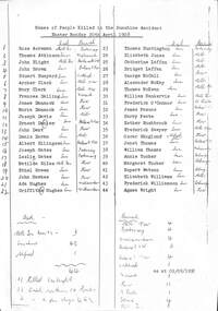 Sunshine and District Historical Society Incorporated
Certificate - Sunshine Rail Disaster death certificates, 1908
... Sunshine Rail Disaster death certificates Death certificates listing the 44 people who died as a result of the railway disaster at Sunshine Station 20th April 1908 Also lists names of those who did at Sunshine Melbourne and Alfred Hospital and place of burial Findings by coroner May and July inquest...Sunshine Railway Disaster Disaster Railways Sunshine Railway Station Printed List of Names of People killed in the Sunshine Accident Easter Monday 20 April 1908 Rose Acreman died Melbourne General Queen Vic Buried Footscray Thomas Atkinson died Sunshine Buried Williamstown John Blight died Melbourne General Queen Vic Buried Ballarat Old John Brown died Sunshine Buried Ballarat Old Stuart Bunyard died Sunshine Buried Oakleigh Archer Clark died Sunshine Buried Melbourne New Mary Clark died Sunshine Buried Melbourne New Frances Dalling died Sunshine Buried Warrick James Dannock died Sunshine Buried Kew Maria Dannock died Sunshine Buried Kew Joseph David died Sunshine Buried Melbourne New Ernest Denier died Sunshine Buried Ballarat New John Dent died Sunshine Buried Kew Denis Doran died Sunshine Buried Melbourne Albert Ellingsen died Sunshine Buried Ballarat New Joseph Gates died Sunshine Buried Footscray Leslie Gates died Sunshine Buried Footscray Matilda Giles died Melbourne General Queen Vic Buried Kew Ethel Green died Sunshine Buried Kew John Haekes died Sunshine Buried Kew Ada Hughes died Sunshine Buried Williamstown Griffith Hughes died Sunshine Buried Williamstown Thomas Huntington died Sunshine Buried Footscray Elizabeth Jones died Sunshine Buried Melbourne Catherine Laffan died Sunshine Buried Melbourne Bridget Laffan died Sunshine Buried Melbourne George McCall died Sunshine Buried Kew Alexander McKay died Sunshine Buried Melbourne Thomas McKean died Sunshine Buried Melbourne William Nankervis died Sunshine Buried Melbourne Frederick OConnor died Sunshine Buried St Kilda James Pascoe died Sunshine Buried Ballarat Old Harry Peate died Sunshine Buried Kew Esther Rushbrook died Sunshine Buried Kew Frederick Sawyer died Sunshine Buried Melbourne Oscar Skoglund died Alfred Buried Kew Janet Thomas died Sunshine Buried Ballarat Old William Thomas died Sunshine Buried Melbourne Annie Tucker died Sunshine Buried Coburg Margaret Tucker died Sunshine Buried Coburg Rupert Watson died Sunshine Buried Coburg Elizabeth Williams died Sunshine Buried Melbourne Frederick Williamson died Sunshine Buried Coburg Agnes Wright died Sunshine Buried Kew A3 photocopy of death registered in the District of East Melbourne in the State of Victoria Sunshine Rail Disaster death certificates Death certificates listing the 44 people who died as a result of the railway disaster at Sunshine Station 20th April 1908 Also lists names of those who did at Sunshine Melbourne and Alfred Hospital and place of burial Findings by coroner May and July inquest Certificate Sunshine Rail Disaster death certificates ...Printed List of Names of People killed in the Sunshine Accident Easter Monday 20 April 1908 Rose Acreman died Melbourne General Queen Vic Buried Footscray Thomas Atkinson died Sunshine Buried Williamstown John Blight died Melbourne General Queen Vic Buried Ballarat Old John Brown died Sunshine Buried Ballarat Old Stuart Bunyard died Sunshine Buried Oakleigh Archer Clark died Sunshine Buried Melbourne New Mary Clark died Sunshine Buried Melbourne New Frances Dalling died Sunshine Buried Warrick James Dannock died Sunshine Buried Kew Maria Dannock died Sunshine Buried Kew Joseph David died Sunshine Buried Melbourne New Ernest Denier died Sunshine Buried Ballarat New John Dent died Sunshine Buried Kew Denis Doran died Sunshine Buried Melbourne Albert Ellingsen died Sunshine Buried Ballarat New Joseph Gates died Sunshine Buried Footscray Leslie Gates died Sunshine Buried Footscray Matilda Giles died Melbourne General Queen Vic Buried Kew Ethel Green died Sunshine Buried Kew John Haekes died Sunshine Buried Kew Ada Hughes died Sunshine Buried Williamstown Griffith Hughes died Sunshine Buried Williamstown Thomas Huntington died Sunshine Buried Footscray Elizabeth Jones died Sunshine Buried Melbourne Catherine Laffan died Sunshine Buried Melbourne Bridget Laffan died Sunshine Buried Melbourne George McCall died Sunshine Buried Kew Alexander McKay died Sunshine Buried Melbourne Thomas McKean died Sunshine Buried Melbourne William Nankervis died Sunshine Buried Melbourne Frederick OConnor died Sunshine Buried St Kilda James Pascoe died Sunshine Buried Ballarat Old Harry Peate died Sunshine Buried Kew Esther Rushbrook died Sunshine Buried Kew Frederick Sawyer died Sunshine Buried Melbourne Oscar Skoglund died Alfred Buried Kew Janet Thomas died Sunshine Buried Ballarat Old William Thomas died Sunshine Buried Melbourne Annie Tucker died Sunshine Buried Coburg Margaret Tucker died Sunshine Buried Coburg Rupert Watson died Sunshine Buried Coburg Elizabeth Williams died Sunshine Buried Melbourne Frederick Williamson died Sunshine Buried Coburg Agnes Wright died Sunshine Buried Kew A3 photocopy of death registered in the District of East Melbourne in the State of Victoriasunshine railway disaster, disaster, railways, sunshine railway station -
 Sunshine and District Historical Society Incorporated
Archive - City of Sunshine
... Typed Report General Information on the City of Sunshine 1987 to 1988|Newspaper Article 13 October 1993 The Age How rubish tips can be a big turn on|Envelope Town Clerk Sunshine City Council|Flyer City of Sunshine Community Day Festival 23 April 1994|Brochure City of Sunshine City of the Future Community Meeting 5 March 1994 Moonee Valley|Brochure City of Sunshine Multicultural City of Victoria Community Meeting 14 September 1991 Moonee Valley|Brochure City of Sunshine The Conferring of The Freedom of Entry to the City of Sunshine Upon The First Try City of Sunshine Regional Cadet Unit on 16 May 1987|Brochure City of Sunshine The Conferring of The Freedom of Entry to the City of Sunshine Upon No 5 Flight Air Training Corps Tottenham 18 November 1989|Photograph and photocopies of building with handwritten notes 444 $136.89|Logo of City of Sunshine Victoria|Brochure Your share in Sunshine City of Sunshine A Progressive Municipality|Brochure City of Sunshine The Conferring of the Freedom of the City of Sunshine upon 5th and 6th Battalion The Royal Victoria Regiment 12 February 1994|Hand drawings with handwritten notes 441 $32.09|Hand drawings with handwritten notes 256 $12.64|Hand drawings with handwritten notes 258 $17.233|Hand drawings with handwritten notes 250 $15.60|Hand drawings with handwritten notes 260 $19.72|Hand drawings with handwritten notes 255 $8.26|Hand drawings with handwritten notes 440 $6.19|Hand drawings with handwritten notes 387 $34.09|Hand drawings with handwritten notes 259 $12.49|Brochure City of Sunshine Development Update October 1988|Newsletter Grapewine City of Sunshine Staff Newsletter June 1992|Typed Letter City of Sunshine Community Bus Information Sheet 21 March 1979|Map Greening Sunshine Current Work in Progress 1992 to 1993|Newspaper Article A Place in the Sun Exotic plants along Railway lines|Flyer Sunshine City Council News Vol 1 No 1 August 1974 Inflation Whats happening to Councils Money|Newspaper Article Footscray Advertiser 17 February 1917 Braybrook Council|Flyer Sunshine City Council News Vol 1 No 1 April 1975 Leaping into Sunshine New World|Flyer Sunshine your city August 1961 Facts you should know Administration commended|Flyer Sunshines Gardens Parks and Streets 1991 to 1992|Invitation sent 28 June 1982 Government Reception to farewell Governor General of the Commonwealth of Australia on 8 July 1982 Commissioner AG and Mrs Gillen at National Gallery of Victoria|City of Sunshine Crest Motto is By Industry|Flyer Sunshine City Burke and Wills Camel Cup 24 April 1994 on Massey Ferguson Harvester site|Booklet Sunshine Yearbook 1972 Suburban Services Directories and Yearbooks|Enrolment form City of Sunshine Holiday Programme 7 May to 18 May 1984|Christmas Wishes Card from Chief Secretary Victoria t0 GM Prendergast Christmas 1927|Typed Letter 1 January 1984 A Personal Invitation from the Mayor|Newspaper Article The Advocate 9 September 1992 Public to have say Brooklyn tug of war|Newspaper Article Local Government Focus Special Feature November 1986 The City of Sunshine Multicultural City of Victoria Message from the Mayor|Brochure City of Sunshine Municipal Profile|Brochure City of Sunshine Accommodating the Future A Strategy for Housing Needs|Brochure Sunshine City Centre Development|Photocopy Mayors City of Sunshine|Brochure Local Solutions to a Global Problem our gift to future generations GEC ALSTHOM Energy Park Hulett St Albion|Brochure Melbournes West on the Move Melbournes Western Region Profile|Brochure Sunshine District Centre Market Square Interchange Public Transport|Certificate of Speical Civic Service for the Municipality of Sunshine|Brochure New Municipal Offices City of Sunshine Victoria|Newspaper Article Sunshine Community 1972 Can you imagine what $800 Million dollars looks like|Brochure Shire of Braybrook Office Welcome Home tendered to Maidstone Returned Services Personnel 2nd August 1946|Brochure City of Sunshine Live work and recreate in Sunshine|Sunshine City Council No 7 Council Report|Section of Minutes 24 March 199 Sunshine Logo competition won by Mr Stephen Jones of Laverton|Photocopy of Mayoral Pendant presented to City of Sunshine by Cr AG Pennel JP to commemorate its proclamatonas a city 16 May 1951|Flyer City of Sunshine Corporation Logo 24 March 1992 The logo was chosen from 94 other logos submitted as part of a community competiiton to find a new corporate logo. ...City of Sunshine Typed Report General Information on the City of Sunshine 1987 to 1988|Newspaper Article 13 October 1993 The Age How rubish tips can be a big turn on|Envelope Town Clerk Sunshine City Council|Flyer City of Sunshine Community Day Festival 23 April 1994|Brochure City of Sunshine City of the Future Community Meeting 5 March 1994 Moonee Valley|Brochure City of Sunshine Multicultural City of Victoria Community Meeting 14 September 1991 Moonee Valley|Brochure City of Sunshine The Conferring of The Freedom of Entry to the City of Sunshine Upon The First Try City of Sunshine Regional Cadet Unit on 16 May 1987|Brochure City of Sunshine The Conferring of The Freedom of Entry to the City of Sunshine Upon No 5 Flight Air Training Corps Tottenham 18 November 1989|Photograph and photocopies of building with handwritten notes 444 $136.89|Logo of City of Sunshine Victoria|Brochure Your share in Sunshine City of Sunshine A Progressive Municipality|Brochure City of Sunshine The Conferring of the Freedom of the City of Sunshine upon 5th and 6th Battalion The Royal Victoria Regiment 12 February 1994|Hand drawings with handwritten notes 441 $32.09|Hand drawings with handwritten notes 256 $12.64|Hand drawings with handwritten notes 258 $17.233|Hand drawings with handwritten notes 250 $15.60|Hand drawings with handwritten notes 260 $19.72|Hand drawings with handwritten notes 255 $8.26|Hand drawings with handwritten notes 440 $6.19|Hand drawings with handwritten notes 387 $34.09|Hand drawings with handwritten notes 259 $12.49|Brochure City of Sunshine Development Update October 1988|Newsletter Grapewine City of Sunshine Staff Newsletter June 1992|Typed Letter City of Sunshine Community Bus Information Sheet 21 March 1979|Map Greening Sunshine Current Work in Progress 1992 to 1993|Newspaper Article A Place in the Sun Exotic plants along Railway lines|Flyer Sunshine City Council News Vol 1 No 1 August 1974 Inflation Whats happening to Councils Money|Newspaper Article Footscray Advertiser 17 February 1917 Braybrook Council|Flyer Sunshine City Council News Vol 1 No 1 April 1975 Leaping into Sunshine New World|Flyer Sunshine your city August 1961 Facts you should know Administration commended|Flyer Sunshines Gardens Parks and Streets 1991 to 1992|Invitation sent 28 June 1982 Government Reception to farewell Governor General of the Commonwealth of Australia on 8 July 1982 Commissioner AG and Mrs Gillen at National Gallery of Victoria|City of Sunshine Crest Motto is By Industry|Flyer Sunshine City Burke and Wills Camel Cup 24 April 1994 on Massey Ferguson Harvester site|Booklet Sunshine Yearbook 1972 Suburban Services Directories and Yearbooks|Enrolment form City of Sunshine Holiday Programme 7 May to 18 May 1984|Christmas Wishes Card from Chief Secretary Victoria t0 GM Prendergast Christmas 1927|Typed Letter 1 January 1984 A Personal Invitation from the Mayor|Newspaper Article The Advocate 9 September 1992 Public to have say Brooklyn tug of war|Newspaper Article Local Government Focus Special Feature November 1986 The City of Sunshine Multicultural City of Victoria Message from the Mayor|Brochure City of Sunshine Municipal Profile|Brochure City of Sunshine Accommodating the Future A Strategy for Housing Needs|Brochure Sunshine City Centre Development|Photocopy Mayors City of Sunshine|Brochure Local Solutions to a Global Problem our gift to future generations GEC ALSTHOM Energy Park Hulett St Albion|Brochure Melbournes West on the Move Melbournes Western Region Profile|Brochure Sunshine District Centre Market Square Interchange Public Transport|Certificate of Speical Civic Service for the Municipality of Sunshine|Brochure New Municipal Offices City of Sunshine Victoria|Newspaper Article Sunshine Community 1972 Can you imagine what $800 Million dollars looks like|Brochure Shire of Braybrook Office Welcome Home tendered to Maidstone Returned Services Personnel 2nd August 1946|Brochure City of Sunshine Live work and recreate in Sunshine|Sunshine City Council No 7 Council Report|Section of Minutes 24 March 199 Sunshine Logo competition won by Mr Stephen Jones of Laverton|Photocopy of Mayoral Pendant presented to City of Sunshine by Cr AG Pennel JP to commemorate its proclamatonas a city 16 May 1951|Flyer City of Sunshine Corporation Logo 24 March 1992 The logo was chosen from 94 other logos submitted as part of a community competiiton to find a new corporate logo. ...Typed Report General Information on the City of Sunshine 1987 to 1988|Newspaper Article 13 October 1993 The Age How rubish tips can be a big turn on|Envelope Town Clerk Sunshine City Council|Flyer City of Sunshine Community Day Festival 23 April 1994|Brochure City of Sunshine City of the Future Community Meeting 5 March 1994 Moonee Valley|Brochure City of Sunshine Multicultural City of Victoria Community Meeting 14 September 1991 Moonee Valley|Brochure City of Sunshine The Conferring of The Freedom of Entry to the City of Sunshine Upon The First Try City of Sunshine Regional Cadet Unit on 16 May 1987|Brochure City of Sunshine The Conferring of The Freedom of Entry to the City of Sunshine Upon No 5 Flight Air Training Corps Tottenham 18 November 1989|Photograph and photocopies of building with handwritten notes 444 $136.89|Logo of City of Sunshine Victoria|Brochure Your share in Sunshine City of Sunshine A Progressive Municipality|Brochure City of Sunshine The Conferring of the Freedom of the City of Sunshine upon 5th and 6th Battalion The Royal Victoria Regiment 12 February 1994|Hand drawings with handwritten notes 441 $32.09|Hand drawings with handwritten notes 256 $12.64|Hand drawings with handwritten notes 258 $17.233|Hand drawings with handwritten notes 250 $15.60|Hand drawings with handwritten notes 260 $19.72|Hand drawings with handwritten notes 255 $8.26|Hand drawings with handwritten notes 440 $6.19|Hand drawings with handwritten notes 387 $34.09|Hand drawings with handwritten notes 259 $12.49|Brochure City of Sunshine Development Update October 1988|Newsletter Grapewine City of Sunshine Staff Newsletter June 1992|Typed Letter City of Sunshine Community Bus Information Sheet 21 March 1979|Map Greening Sunshine Current Work in Progress 1992 to 1993|Newspaper Article A Place in the Sun Exotic plants along Railway lines|Flyer Sunshine City Council News Vol 1 No 1 August 1974 Inflation Whats happening to Councils Money|Newspaper Article Footscray Advertiser 17 February 1917 Braybrook Council|Flyer Sunshine City Council News Vol 1 No 1 April 1975 Leaping into Sunshine New World|Flyer Sunshine your city August 1961 Facts you should know Administration commended|Flyer Sunshines Gardens Parks and Streets 1991 to 1992|Invitation sent 28 June 1982 Government Reception to farewell Governor General of the Commonwealth of Australia on 8 July 1982 Commissioner AG and Mrs Gillen at National Gallery of Victoria|City of Sunshine Crest Motto is By Industry|Flyer Sunshine City Burke and Wills Camel Cup 24 April 1994 on Massey Ferguson Harvester site|Booklet Sunshine Yearbook 1972 Suburban Services Directories and Yearbooks|Enrolment form City of Sunshine Holiday Programme 7 May to 18 May 1984|Christmas Wishes Card from Chief Secretary Victoria t0 GM Prendergast Christmas 1927|Typed Letter 1 January 1984 A Personal Invitation from the Mayor|Newspaper Article The Advocate 9 September 1992 Public to have say Brooklyn tug of war|Newspaper Article Local Government Focus Special Feature November 1986 The City of Sunshine Multicultural City of Victoria Message from the Mayor|Brochure City of Sunshine Municipal Profile|Brochure City of Sunshine Accommodating the Future A Strategy for Housing Needs|Brochure Sunshine City Centre Development|Photocopy Mayors City of Sunshine|Brochure Local Solutions to a Global Problem our gift to future generations GEC ALSTHOM Energy Park Hulett St Albion|Brochure Melbournes West on the Move Melbournes Western Region Profile|Brochure Sunshine District Centre Market Square Interchange Public Transport|Certificate of Speical Civic Service for the Municipality of Sunshine|Brochure New Municipal Offices City of Sunshine Victoria|Newspaper Article Sunshine Community 1972 Can you imagine what $800 Million dollars looks like|Brochure Shire of Braybrook Office Welcome Home tendered to Maidstone Returned Services Personnel 2nd August 1946|Brochure City of Sunshine Live work and recreate in Sunshine|Sunshine City Council No 7 Council Report|Section of Minutes 24 March 199 Sunshine Logo competition won by Mr Stephen Jones of Laverton|Photocopy of Mayoral Pendant presented to City of Sunshine by Cr AG Pennel JP to commemorate its proclamatonas a city 16 May 1951|Flyer City of Sunshine Corporation Logo 24 March 1992 The logo was chosen from 94 other logos submitted as part of a community competiiton to find a new corporate logo. Designer ws Mr Steve Jones of Laverton.|Sunshine District Centre Aerial Perspective Market Sqaure : Pollard Reserve : The Overpass and Railway Line sketchcity of sunshine -
 Eltham District Historical Society Inc
Document, Russell Yeoman, Tour of Historic Buildings and Locations, 1978
... ELTHAM CENTPAL PARK The area between the railway and the creek has for many years been used as a park which included Eltham' s main football oval. The access road, Panther Place is named after Eltham's team playing in the Diamond Valley League. ...ELTHAM CENTPAL PARK The area between the railway and the creek has for many years been used as a park which included Eltham' s main football oval. The access road, Panther Place is named after Eltham's team playing in the Diamond Valley League. ...Self guided heritage tour information produced by the Shire of Eltham Historical Society for 1978 Eltham Community Festival of 36 locations each numbered on accompanying map. Locations and detail provided current to 1978: 1. ELTHAM SHOPPING CENTRE Whilst very little remains in the centre of historical importance, this area has interest as the "village" which developed over many years following the opening of the railway from Melbourne in 1902. Previously the shopping centre had been spread out over a long length of Main Road to the south. Shops have been continuously demolished or remodelled and the majority of buildings date from the 1950's or later. The recently erected Post Office replaced the "old" Post Office opened on the same site only in 1958. 2. WOOLWORTHS ELTHAM VILLAGE Part of the site of this modern shopping development was occupied by the former Eltham Shire Offices and Hall. The hall was paid for by public subscription whilst the Council raised a loan for the offices. The combined building was opened in 1941. It served as office and Council meeting place until 1965 and as the hall until its demolition in 1970. 3. ELTHAM WAR MEMORIAL The complex of buildings adjoining the present Shire Offices were financed by public subscription as a Memorial following World War II. Their construction and for many years their operation was organised by the now disbanded Eltham War Memorial Committee. The original buildings were the; Infant Welfare Centre, Children’s Library (now War Memorial Hall and Dental Clinic) and Kindergarten. In later years the Elderly Citizens Club was built at the rear. 4. ELTHAM SHIRE OFFICES These offices were opened in 1965 and extended in 1971 to provide additional office accommodation and the Eltham Library. They represent the last of a long line of offices and meeting places of the Eltham Shire Council and its predecessor the Eltham District Road Board. The building occupies the former site of Shillinglaw Cottage. The three tall cypress trees which stood in front of the Cottage have been retained as a feature of the office surrounds. 5. OUR LADY'S CHURCH AND SCHOOL The Catholic Church and School complex opposite the Shires Offices shows a number of stages in the development of Eltham township. The recently constructed church adjoins its predecessor (now the parish centre). Many years ago the Catholic Church was located opposite Wingrove Park and the present central site follows the northerly drift of the township. 6. SHILLINGLAW COTTAGE The Cottage was built in 1859 by George Stebbing, a local builder who was responsible for a number of other prominent buildings in the area. Its removal from the site of the Shire Offices and re-erection on the present site was financed by public subscription. It is built of handmade bricks laid in Flemish Bond with an unusual design featuring burnt "leader" bricks over the whole facade. The Cottage is occupied by Eltham Fleececrafts and will be open during the Festival and at other times during weekends. It is classified by the National Trust. 7. RAILWAY BRIDGE The timber trestle bridge over the Diamond Creek was built in 1901. Whilst all of its timbers have been replaced at various times over the years the only change to its character has been the addition of pylons and wiring for electric trains in 1923. It is one of very few similar bridges remaining in the metropolitan area. In 1976 a proposal to replace the bridge with an earth embankment and large culvert pipes was abandoned following community protests. The bridge, however, remains under threat because of the necessity for future deuplication of the railway line. 8. ELTHAM CENTPAL PARK The area between the railway and the creek has for many years been used as a park which included Eltham' s main football oval. The access road, Panther Place is named after Eltham's team playing in the Diamond Valley League. In recent years a large area extending to Bridge Street and locally known as the Town Park has been landscaped and added to the area. The excellent blending of the park with the natural landscape of the creek valley has earned a National Trust Landscape Classification. 9. OLD BAKERY On the southern corner of York Street and Main Road is an old house with a shop front which was for many years the local baker's shop. The brick bakery at the rear is of somewhat later vintage than the house. 10. BRIDGE STREET CUTTING Before reconstruction of Main Road this intersection had deep cutting embankments on all four corners, forming a distinctive feature of the entrance to Eltham. Roadworks and private development have levelled the land on the low side of the road. A memorial to the Eltham soldiers of World War I which was located at the north-western corner is now situated at the Eltham R.S.L. 11. HILLTOP MILK BAR For many years this was the site of the Eltham Post Office under the control of the Hunniford family and later their descendants the Burgoynes. It was transferred to this site in 1855, although at that time the building apparently fronted Bridge Str e et. The site contained Eltham's first telephone exchange. The post office was relocated in 1954 but the shop was operated until recently by the Burgoyne family who still own the surrounding land. 12. UNITING CHURCH and former C.B.A. BANK The former Methodist Church was built in 1880 by George Stebbing. The Sunday School extension was built in 1929 and there have been more recent extensions. The adjoining opportunity shop was built as a bank in 1874 and purchased by the Methodist Church in 1954. 13. R.S.L. HALL, TELEPHONE EXCHANGE These relatively recent buildings occupy the site of a row of shops forming part of the early ribbon of business development along Main Road. In front of the R.S.L. building is the World War I Memorial relocated from the corner of Bridge Street and Main Road. 14. ELTHAM COMMUNITY CENTRE Australia's first mudbrick "community building" was opened in April this year. Part of the site of the building was purchased in 1856 by Henry Dendy (of Brighton fame). At the rear of the land near the creek was a steam flour mill whilst Dendy's house was at the Main Road frontage of the land. His purchase totalled about 2 Ha (5 acres) and included land on the opposite side of Maria Street (Main Road). Dendy became a prominent member of the Eltham community and served one term as President of the Eltham District Road Board. In 1867 Dendy sold his land and business to William Ford of Malmsbury and shifted to Walhalla. The avenue of trees leading past the Community Centre to the creek may well have bordered the track to the mill. 15. ELTHAM HOTEL The original part of this hotel was built in 1927 following the burning of the former Watson's Eltham Hotel on the same site. The car park on the opposite side of Main Road was also the site of a hotel variously known over the years as; the Fountain of Friendship, the Fountain and the Evelyn Arms. As the Fountain of Friendship it was the first meeting place of the Eltham District Road Board in 1856. 16. ST. MARGARET'S CHURCH, PITT STREET In 1860 Henry Dendy was appointed Chairman of a committee to establish a church of England in Eltham. He donated part of his land in Pitt Street and in 1861 the church was opened. It was built by George Stebbing and remains in a well preserved state today. Th adjoining old vicarage is now named Dendy Hou se. A new mudbrick church hall is under construction on the site. The church and Dendy House are now listed on the Register of Historic Buildings. 17. NO. 86 PITT STREET Cottage built by George Stebbing and believed to be his home for some years in the 1850s. 18. LIVING AND LEARNING CENTRE The house was built in the 1850s with the kitchen at the front being added about 40 years later. By the creek below the house a number of early Eltham industries were located. These included a tannery and a brewery. 19. ELTHAM COURT HOUSE A Court of Petty Sessions was established in Eltham in 1858 and the present building dates from 1860. It is the oldest public building remaining in Eltham. In its early days the building was used as the meeting place and office of the Eltham District Road Board and as an overflow classroom for the local school. The Court House has been classified by the National Trust. The citation states that it is an example of the simple form of early brick Court House with gabled roof and porch. 20. LANDS DEPARTMENT OFFICE This building is the former police station and is probably of about the same age as the Court House. The lockup at the rear has been demolished but the old stables remain as garages. A licence was first granted for a police station at Eltham in 1856. 21. JARROLD COTTAGE The old Cottage opposite Dalton Street was formerly owned by the Jarrold family. Early records indicate that this was the building leased from the Jarrolds as a temporary police station prior to construction of the building on the corner of Brougham Street. The small building on the corner of the property was used as a boot repairer's shop. The elevated studio at the rear is a more recent construction by the present owners. 22. STATE SCHOOL RESIDENCE Erected in 1891 23. WINGROVE COTTAGE This building fills an important place in the history of Eltham and is now used as a medical clinic. It was built in 1858 for Charles S. Wingrove who was Secretary to the Eltham District Road Board and Shire Council from 1858 to 1904. During part of this period he was also Shire Engineer and was Secretary to the Heidelberg Road Board. The house was used as the office of the Board and Council for many years. Wingrove is buried in the cemetery at St. Helena. 24. WINGROVE PARK The parkland opposite Wingrove Cottage has been named after Charles Wingrove. The old Manna Gums are an outstanding feature of the park. 25. ELTHAM FRI.MARY SCHOOL NO. 209 The school first opened in the slab building in 1855 and operated from the present site since 1857. The oldest part of the present school is the stone building erected in 1876. The first school teacher, David Clark remained at the school until 1888. This school is the government township and has always been known as the Eltham School. An earlier school (no.371) known as Little Eltham School operated in Swan Street from 1853 to 1872. 26. "SHOESTRING" This house was built for school teacher David Clark. It has been extensively extended in recent years but the extensions do not detract from the character of the older part of the building. 27. ELTHAM CEMETERY The cemetery contains the graves of many of the district's pioneers . 28. MONTSALVAT This unique complex of buildings was commenced in 1935 by the late Justus Jorgensen and its development has extended over many years. Montsalvat has exerted a significant impact on Eltham The earth and stone construction of many of the buildings has influenced local architecture to a great extent and it has served as a "nerve centre" of the local artistic community. Montsalvat is open to the public for a small charge. 29. MAIN ROAD BRIDGE This location has been the main crossing of Diamond Creek since the earliest days of settlement. The present concrete bridge was erected in 1925 .and was preceded by a number of timber bridges. 30. ELTHAM LOWER PARK This park, being an unusually large flat area for Eltham, was originally the local racecourse. Horse races were held here from 1855 and the area was gazetted as a reserve for a racecourse and recreation reserve in 1857. The park is well known as a venue for school "bird days" and more recently as the site of the Diamond Valley Railway. This miniature railway features scale models of modern and old locomotives and rolling stock and has operated on this site since 1961 . Before that the railway operated at Chelsworth Park, Ivanhoe. 31. FALKINER HOUSE Frederick Falkiner was one of the earliest settlers in the Eltham township area and occupied a substantial leasehold prior to the first land sales. Early records show that Falkiner was the subject of a number of complaints from his neighbours but he has nevertheless been considered a prominent enough citizen to have a street named for him. This house was the home of Evelyn (Ely) Falkiner a member of Frederick's family. 32. WEST HOUSE Behind the large house on the hill is an early house built by the West family. This was relocated from a site near the front of the land by the present owner Mr. Fabbro. 33. FALKINER HOUSE This very old house is believed to have been the home of Frederick and may have been Eltham's first post office. Falkiner was the first post master for a short period. in 1854/55. 34. WITHERS HOUSE This house was the home of famous artist Walter Withers who shifted here from Heidelberg in 1903. 35. ELTHAM HIGH SCHOOL This school celebrated its jubilee this year, having commenced as the Eltham Higher Elementary School 50 years ago. 36. DIAMOND CREEK FOOTWAY If returning from the High School to the town centre the footpath by the bank of the Diamond Creek provides a pleasant route to finish your walk. The creek is a major tributary of the Yarra River. Together with its own major tributaries Arthurs Creek and Running Creek it commences on the southern slopes of the Dividing Range at Kinglake. It gives the name Diamond Valley to an area extending well beyond its actual drainage catchment.Recognition of the significance of various landmarks to the history of the Eltham community as of 1978‘shoestring’, 1978, bridge street cutting, burgoyne store, c.b.a. bank, diamond creek trail, eltham cemetery, eltham central park, eltham community centre, eltham community festival, eltham court house, eltham festival, eltham high school, eltham hotel, eltham lower park, eltham primary school, eltham railway trestle bridge, eltham shire offices, eltham shopping centre, eltham state school no. 209, eltham village, eltham war memorial, falkiner house, heritage trail, hilltop milk bar, jarrold cottage, lands department office, living, living and learning centre, main road bridge, montsalvat, old bakery, our eltham artistic recollections, our lady help of christian’s church, our lady help of christian’s primary school, pitt street, post office, r.s.l. hall, shillinglaw cottage, st margaret’s church, state school residence, stebbing cottage, telephone exchange, uniting church, west house, wingrove cottage, wingrove park, withers house, woolworths -
 Sunshine and District Historical Society Incorporated
Archive - Deer Park Landmarks
... Photocopy of photograph Category 140 Deer Park State School 2434 Built 1874 Early 19th Century|Photocopy of drawing of Hunt Club community Centre Ballarat Road Deer Park|Hand written notes for Deer Park by Norm Carlton|Photocopy of Article Deer Hunting In Australia Supplied by Des Johnson Oct 1997|Photocopy of Article Deer Park Over the Years|Photocopy of Article Deer Park Landmarks|Photocopy of typed report Deer Park History|Photocopy of report ICI and Deer Park A Long Term Association|Photocopy of letter dated 19 December 1993|Photocopy of typed notes Pioneers of the Deer Park Districk|Report from ICI Contrasts and continuity|Photocopy of Newspaper Article This Family has 267 Years service with one firm|Photocopy of ICI Circle Newspaper 31 May 1978 50 years|Photocopy of Service Directory Brimbanks Suburbs|Photocopy of Newspaper Article Wandering around Werribee|Newspaper Article Western Independent 31 August 1993 As one gate closes|Photocopy of Newspaper Article Fighting fires was worth a lemonade|Newspaper Article The Advocate 25 January 2000 Hands Off Residents fight for their castle|Newspaper Article Deer Park once the perfect place for a social shoot|Newspaper Article the Advocate 15 April 1992 A heart for Deer Park|Report Brimbank Community Plan 2009 to 2030 Deer Park Local Area Pland SouthWest|Photocopy of photograph 1956 Class of Deer Park State Primary Schoole 1434 1 Reg Spratling 2 Ian Sutherland 3 Ken Brown 4 Bob Foley 5 Alec OBrien 6 Maurie Hunter 7 Unknown 8 Jack fisher 9 Stan Brown 10 Lester Musely 11 Unknow 12 Gwen Gray 13 Claire Robinson 14 Norma Johnson 15 Joyce Cronin 16 Marge Robinson 17 Violet Fisher 18 Gena Thomas 19 Vida Mosely 20 Unknown 21 Jessie Boobey 22 Dorothy Hilton 23 Mabel Barry 24 Elsie MacLeod 25 Marge Byrne 26 Ella Burgess 27 Unknown 28 Vi Wilson 29 Dulcie Ross 30 Daisy Thomas 31 Johnson 32 Fay Johnson 33 Unknown 34 Unknown 35 Harold OBrien 36 Unknown 37 Alan Obrien 38 Bruce Sutherland 39 Roland Foley 40 Matthew David Ure 41 Bob Barnett 42 burton Hunter 43 Harry MacLeod 44 Jim Lawrence 45 Joe Lawrence|Photocopy of Program Share your membories of Early Deer Park at the Deer Park History Afternoon 21 September 2003|Photocopy of hand written notes Deer Park History Day 21 September 2003 Attendance Sheet|Photocopy of written report community Profile and Resource File May 2002|Brochure Burnside News Issue 2 2001 Burnside A great place for your family|Brochure Burnside within reach beyond expectation 2001 to 2002|Photocopy of Newsrail October 1993 Deer Park Again|Photocopy of Occupation Crossings|Photocopy of PCR Crossings|Photocopy of Victorian Railways Map for Footscray and Bacchus Marsh Line|Handwritten Notes for Deer Park|Handwritten Notes for Deer Park Goods Shed|Handwritten Notes for Deer Park Weekly Notice Extracts|Type written Notes for Weekly Notice extracts|Photocopy of Victorian Railways Names of Victorian Railway Stations|Photocopy of Railway construction No 682|Photocopy of newsrail July 2009 TailDisc Ravenhall|Photocopy of Newspaper Article Sunshine Illustrated 21 May 1960 Imperial Chemical Industries has immense Plant at Deer Park|Type written report for Mt Derrimut|Newspaper Article Brimbank Independent 8 June 1999 Council furphy upsets former cycling champ|Newspaper Article The Advocate 26 Feburay 2002 Built a business from ground Up Obituary David Ure|Photocopy Newspaper Article Mount Derrimut From a Colonys past to a Countrys Future|Newspaper Article Bowls News and Views December 1980 Deer Park Snippets of History|Photocopy of type written report Opening of Sunshine Hunt Club Commuity Centre 2 June 1985|Draft report Hunt Club Community Centre Glimpses of Early History of site|Letter dated 19 May 1984 Sunshine and District Historical Society|Letter Deer Park Services Coordinating Group|Letter dated 6 July 1983 Deer Park North Primary School|Newspaper Article Deer roamed the plains|Newspaper Article Brimbank Leader 12 March 2002 Population boom sounds over west|Newspaper Article The Advocate 13 February 2001 Book walks the wild side|Photocopy of Newspaper Article The Sun News Pictorial 19 September 1935 Two Men killed in explosion at Ammunition Factory James Robertson and Harry Powell|Photocopy of Oblique aerial photograph 1950|Letter Dated 24 September 1980 Deer Park Primary School|Type written Notes Deer Park History Afternoon 21 September 2003 Suggested order of proceedings|Hand written note ICI purchased Mt Derrimut August 1950|Photocopy of letter dated 21 July 1992 ICI Deer Park|Brochure ICI Australia today|Photocopy of Notice Know Our History the Story of ICI at Deer Park 13 October 1996|Type written note 100 years of Deer Park State School and the Deer Park District|Photocopy of Newspaper Article School on the move Fighting fires was worth a lemonade|Newspaper Article Messenger 25 January 2000 Old and homely and not historic|Photocopy of Newspaper Article The Sun 19 September 1935 Two men killed in Explosion at Deer Park|Newspaper Article Star 10 June 2003 Heritage plan for homestead|Photocopy of photograph Deer Park Amateur Cycling Club Eary 1930s H OBrien D Gray J Chapman Trainer E OBrien L Ray|Type written note An Early Irish Family at Deer Park|Type written extract Melbourn Hunt Club weights|Type written invitation to Deer Park Entertainers 1 October|Photocopy of Newspaper Article The Advocate 25 July 1979 Deer roamed the plains|Report on historical background of site of proposed new station at Deer Park West March 1977...Deer Park History Landmarks Photocopy of photograph Category 140 Deer Park State School 2434 Built 1874 Early 19th Century|Photocopy of drawing of Hunt Club community Centre Ballarat Road Deer Park|Hand written notes for Deer Park by Norm Carlton|Photocopy of Article Deer Hunting In Australia Supplied by Des Johnson Oct 1997|Photocopy of Article Deer Park Over the Years|Photocopy of Article Deer Park Landmarks|Photocopy of typed report Deer Park History|Photocopy of report ICI and Deer Park A Long Term Association|Photocopy of letter dated 19 December 1993|Photocopy of typed notes Pioneers of the Deer Park Districk|Report from ICI Contrasts and continuity|Photocopy of Newspaper Article This Family has 267 Years service with one firm|Photocopy of ICI Circle Newspaper 31 May 1978 50 years|Photocopy of Service Directory Brimbanks Suburbs|Photocopy of Newspaper Article Wandering around Werribee|Newspaper Article Western Independent 31 August 1993 As one gate closes|Photocopy of Newspaper Article Fighting fires was worth a lemonade|Newspaper Article The Advocate 25 January 2000 Hands Off Residents fight for their castle|Newspaper Article Deer Park once the perfect place for a social shoot|Newspaper Article the Advocate 15 April 1992 A heart for Deer Park|Report Brimbank Community Plan 2009 to 2030 Deer Park Local Area Pland SouthWest|Photocopy of photograph 1956 Class of Deer Park State Primary Schoole 1434 1 Reg Spratling 2 Ian Sutherland 3 Ken Brown 4 Bob Foley 5 Alec OBrien 6 Maurie Hunter 7 Unknown 8 Jack fisher 9 Stan Brown 10 Lester Musely 11 Unknow 12 Gwen Gray 13 Claire Robinson 14 Norma Johnson 15 Joyce Cronin 16 Marge Robinson 17 Violet Fisher 18 Gena Thomas 19 Vida Mosely 20 Unknown 21 Jessie Boobey 22 Dorothy Hilton 23 Mabel Barry 24 Elsie MacLeod 25 Marge Byrne 26 Ella Burgess 27 Unknown 28 Vi Wilson 29 Dulcie Ross 30 Daisy Thomas 31 Johnson 32 Fay Johnson 33 Unknown 34 Unknown 35 Harold OBrien 36 Unknown 37 Alan Obrien 38 Bruce Sutherland 39 Roland Foley 40 Matthew David Ure 41 Bob Barnett 42 burton Hunter 43 Harry MacLeod 44 Jim Lawrence 45 Joe Lawrence|Photocopy of Program Share your membories of Early Deer Park at the Deer Park History Afternoon 21 September 2003|Photocopy of hand written notes Deer Park History Day 21 September 2003 Attendance Sheet|Photocopy of written report community Profile and Resource File May 2002|Brochure Burnside News Issue 2 2001 Burnside A great place for your family|Brochure Burnside within reach beyond expectation 2001 to 2002|Photocopy of Newsrail October 1993 Deer Park Again|Photocopy of Occupation Crossings|Photocopy of PCR Crossings|Photocopy of Victorian Railways Map for Footscray and Bacchus Marsh Line|Handwritten Notes for Deer Park|Handwritten Notes for Deer Park Goods Shed|Handwritten Notes for Deer Park Weekly Notice Extracts|Type written Notes for Weekly Notice extracts|Photocopy of Victorian Railways Names of Victorian Railway Stations|Photocopy of Railway construction No 682|Photocopy of newsrail July 2009 TailDisc Ravenhall|Photocopy of Newspaper Article Sunshine Illustrated 21 May 1960 Imperial Chemical Industries has immense Plant at Deer Park|Type written report for Mt Derrimut|Newspaper Article Brimbank Independent 8 June 1999 Council furphy upsets former cycling champ|Newspaper Article The Advocate 26 Feburay 2002 Built a business from ground Up Obituary David Ure|Photocopy Newspaper Article Mount Derrimut From a Colonys past to a Countrys Future|Newspaper Article Bowls News and Views December 1980 Deer Park Snippets of History|Photocopy of type written report Opening of Sunshine Hunt Club Commuity Centre 2 June 1985|Draft report Hunt Club Community Centre Glimpses of Early History of site|Letter dated 19 May 1984 Sunshine and District Historical Society|Letter Deer Park Services Coordinating Group|Letter dated 6 July 1983 Deer Park North Primary School|Newspaper Article Deer roamed the plains|Newspaper Article Brimbank Leader 12 March 2002 Population boom sounds over west|Newspaper Article The Advocate 13 February 2001 Book walks the wild side|Photocopy of Newspaper Article The Sun News Pictorial 19 September 1935 Two Men killed in explosion at Ammunition Factory James Robertson and Harry Powell|Photocopy of Oblique aerial photograph 1950|Letter Dated 24 September 1980 Deer Park Primary School|Type written Notes Deer Park History Afternoon 21 September 2003 Suggested order of proceedings|Hand written note ICI purchased Mt Derrimut August 1950|Photocopy of letter dated 21 July 1992 ICI Deer Park|Brochure ICI Australia today|Photocopy of Notice Know Our History the Story of ICI at Deer Park 13 October 1996|Type written note 100 years of Deer Park State School and the Deer Park District|Photocopy of Newspaper Article School on the move Fighting fires was worth a lemonade|Newspaper Article Messenger 25 January 2000 Old and homely and not historic|Photocopy of Newspaper Article The Sun 19 September 1935 Two men killed in Explosion at Deer Park|Newspaper Article Star 10 June 2003 Heritage plan for homestead|Photocopy of photograph Deer Park Amateur Cycling Club Eary 1930s H OBrien D Gray J Chapman Trainer E OBrien L Ray|Type written note An Early Irish Family at Deer Park|Type written extract Melbourn Hunt Club weights|Type written invitation to Deer Park Entertainers 1 October|Photocopy of Newspaper Article The Advocate 25 July 1979 Deer roamed the plains|Report on historical background of site of proposed new station at Deer Park West March 1977 Newspaper clippings history photographs relating to Deer Park. ...Photocopy of photograph Category 140 Deer Park State School 2434 Built 1874 Early 19th Century|Photocopy of drawing of Hunt Club community Centre Ballarat Road Deer Park|Hand written notes for Deer Park by Norm Carlton|Photocopy of Article Deer Hunting In Australia Supplied by Des Johnson Oct 1997|Photocopy of Article Deer Park Over the Years|Photocopy of Article Deer Park Landmarks|Photocopy of typed report Deer Park History|Photocopy of report ICI and Deer Park A Long Term Association|Photocopy of letter dated 19 December 1993|Photocopy of typed notes Pioneers of the Deer Park Districk|Report from ICI Contrasts and continuity|Photocopy of Newspaper Article This Family has 267 Years service with one firm|Photocopy of ICI Circle Newspaper 31 May 1978 50 years|Photocopy of Service Directory Brimbanks Suburbs|Photocopy of Newspaper Article Wandering around Werribee|Newspaper Article Western Independent 31 August 1993 As one gate closes|Photocopy of Newspaper Article Fighting fires was worth a lemonade|Newspaper Article The Advocate 25 January 2000 Hands Off Residents fight for their castle|Newspaper Article Deer Park once the perfect place for a social shoot|Newspaper Article the Advocate 15 April 1992 A heart for Deer Park|Report Brimbank Community Plan 2009 to 2030 Deer Park Local Area Pland SouthWest|Photocopy of photograph 1956 Class of Deer Park State Primary Schoole 1434 1 Reg Spratling 2 Ian Sutherland 3 Ken Brown 4 Bob Foley 5 Alec OBrien 6 Maurie Hunter 7 Unknown 8 Jack fisher 9 Stan Brown 10 Lester Musely 11 Unknow 12 Gwen Gray 13 Claire Robinson 14 Norma Johnson 15 Joyce Cronin 16 Marge Robinson 17 Violet Fisher 18 Gena Thomas 19 Vida Mosely 20 Unknown 21 Jessie Boobey 22 Dorothy Hilton 23 Mabel Barry 24 Elsie MacLeod 25 Marge Byrne 26 Ella Burgess 27 Unknown 28 Vi Wilson 29 Dulcie Ross 30 Daisy Thomas 31 Johnson 32 Fay Johnson 33 Unknown 34 Unknown 35 Harold OBrien 36 Unknown 37 Alan Obrien 38 Bruce Sutherland 39 Roland Foley 40 Matthew David Ure 41 Bob Barnett 42 burton Hunter 43 Harry MacLeod 44 Jim Lawrence 45 Joe Lawrence|Photocopy of Program Share your membories of Early Deer Park at the Deer Park History Afternoon 21 September 2003|Photocopy of hand written notes Deer Park History Day 21 September 2003 Attendance Sheet|Photocopy of written report community Profile and Resource File May 2002|Brochure Burnside News Issue 2 2001 Burnside A great place for your family|Brochure Burnside within reach beyond expectation 2001 to 2002|Photocopy of Newsrail October 1993 Deer Park Again|Photocopy of Occupation Crossings|Photocopy of PCR Crossings|Photocopy of Victorian Railways Map for Footscray and Bacchus Marsh Line|Handwritten Notes for Deer Park|Handwritten Notes for Deer Park Goods Shed|Handwritten Notes for Deer Park Weekly Notice Extracts|Type written Notes for Weekly Notice extracts|Photocopy of Victorian Railways Names of Victorian Railway Stations|Photocopy of Railway construction No 682|Photocopy of newsrail July 2009 TailDisc Ravenhall|Photocopy of Newspaper Article Sunshine Illustrated 21 May 1960 Imperial Chemical Industries has immense Plant at Deer Park|Type written report for Mt Derrimut|Newspaper Article Brimbank Independent 8 June 1999 Council furphy upsets former cycling champ|Newspaper Article The Advocate 26 Feburay 2002 Built a business from ground Up Obituary David Ure|Photocopy Newspaper Article Mount Derrimut From a Colonys past to a Countrys Future|Newspaper Article Bowls News and Views December 1980 Deer Park Snippets of History|Photocopy of type written report Opening of Sunshine Hunt Club Commuity Centre 2 June 1985|Draft report Hunt Club Community Centre Glimpses of Early History of site|Letter dated 19 May 1984 Sunshine and District Historical Society|Letter Deer Park Services Coordinating Group|Letter dated 6 July 1983 Deer Park North Primary School|Newspaper Article Deer roamed the plains|Newspaper Article Brimbank Leader 12 March 2002 Population boom sounds over west|Newspaper Article The Advocate 13 February 2001 Book walks the wild side|Photocopy of Newspaper Article The Sun News Pictorial 19 September 1935 Two Men killed in explosion at Ammunition Factory James Robertson and Harry Powell|Photocopy of Oblique aerial photograph 1950|Letter Dated 24 September 1980 Deer Park Primary School|Type written Notes Deer Park History Afternoon 21 September 2003 Suggested order of proceedings|Hand written note ICI purchased Mt Derrimut August 1950|Photocopy of letter dated 21 July 1992 ICI Deer Park|Brochure ICI Australia today|Photocopy of Notice Know Our History the Story of ICI at Deer Park 13 October 1996|Type written note 100 years of Deer Park State School and the Deer Park District|Photocopy of Newspaper Article School on the move Fighting fires was worth a lemonade|Newspaper Article Messenger 25 January 2000 Old and homely and not historic|Photocopy of Newspaper Article The Sun 19 September 1935 Two men killed in Explosion at Deer Park|Newspaper Article Star 10 June 2003 Heritage plan for homestead|Photocopy of photograph Deer Park Amateur Cycling Club Eary 1930s H OBrien D Gray J Chapman Trainer E OBrien L Ray|Type written note An Early Irish Family at Deer Park|Type written extract Melbourn Hunt Club weights|Type written invitation to Deer Park Entertainers 1 October|Photocopy of Newspaper Article The Advocate 25 July 1979 Deer roamed the plains|Report on historical background of site of proposed new station at Deer Park West March 1977deer park, history, landmarks -
 Sunshine and District Historical Society Incorporated
Archive - Places of Historic Interest in and around St Albans 2013, Missen Alie Compiler
... Places of Historic Interest in and around St Albans|The ABC Radio mast and transmitter station|The Blue stone Culvert bridge|Sydenham railway station|Robertsons Upper Keilor Homestead|A Sheep Dip|The Overnewton Venue|The Overnewton Gatehouse|Anderson Cottage|the Hume and Hovell Cairn| Keighlo|St Albans Railway Reserve Grasslands|The Anderson Farm House|The St George Fee Serbian Orthodox Church|The Agnes Stevens farmhouse|The Stensons Family Farm|The Errington Reserve Gates|The St Albans Community Youth Centre|St Albans Town Plan|St Albans Uniting Church...Albans Harrsion Places of Historic Interest in and around St Albans|The ABC Radio mast and transmitter station|The Blue stone Culvert bridge|Sydenham railway station|Robertsons Upper Keilor Homestead|A Sheep Dip|The Overnewton Venue|The Overnewton Gatehouse|Anderson Cottage|the Hume and Hovell Cairn| Keighlo|St Albans Railway Reserve Grasslands|The Anderson Farm House|The St George Fee Serbian Orthodox Church|The Agnes Stevens farmhouse|The Stensons Family Farm|The Errington Reserve Gates|The St Albans Community Youth Centre|St Albans Town Plan|St Albans Uniting Church Places of Historic Interest in and around St Albans 2013 Compiled by Alie Missen Archive Places of Historic Interest in and around St Albans 2013 Missen Alie Compiler ...Places of Historic Interest in and around St Albans|The ABC Radio mast and transmitter station|The Blue stone Culvert bridge|Sydenham railway station|Robertsons Upper Keilor Homestead|A Sheep Dip|The Overnewton Venue|The Overnewton Gatehouse|Anderson Cottage|the Hume and Hovell Cairn| Keighlo|St Albans Railway Reserve Grasslands|The Anderson Farm House|The St George Fee Serbian Orthodox Church|The Agnes Stevens farmhouse|The Stensons Family Farm|The Errington Reserve Gates|The St Albans Community Youth Centre|St Albans Town Plan|St Albans Uniting Churchst. albans, harrsion -
 Sunshine and District Historical Society Incorporated
Memorabilia - Sunshine and District Historical Society 50th Anniversary Place Mat
... Laminated Place Mat for Sunshine and District Historical Society 50th Anniversary 1972 to 2022|Place Mat ideas Hugh Victor McKay Harold Blair Blair Athol Olwen Ford Reverend John Flynn Headlie S Taylor Sunshine HV McKay Gardens Anderson Road Braybrook Hotel Ballarat Road Braybrook Hotel Derrimut Sun Crescent Sunshine Court House and Police Station Sun Crescent Hunt Club Deer Park ETA Factory WG Thomas Butcher Sunshine Advocate|Photograph HV McKay Gardens|Photograph Sunshine Railway Station|Photograph Room with TC|Photograph Stone building with children|Photograph Band Rotunda Sunshine|Photograph Aerial photo of Sunshine|Photograph of rail and wagons|Photograph of Braybrook Hotel|Photograph of Nettlefolds Screw Works|Invitation 50 years Annual Pioneers Lunch 20 November 2022 Sunshine RSL 99 Dickson Street Sunshine...The place mat was designed by Melchior "Mel" Bajada and the lamination orgainsed by Alan Dash Sunshine & District Historical Society Laminated Place Mat for Sunshine and District Historical Society 50th Anniversary 1972 to 2022|Place Mat ideas Hugh Victor McKay Harold Blair Blair Athol Olwen Ford Reverend John Flynn Headlie S Taylor Sunshine HV McKay Gardens Anderson Road Braybrook Hotel Ballarat Road Braybrook Hotel Derrimut Sun Crescent Sunshine Court House and Police Station Sun Crescent Hunt Club Deer Park ETA Factory WG Thomas Butcher Sunshine Advocate|Photograph HV McKay Gardens|Photograph Sunshine Railway Station|Photograph Room with TC|Photograph Stone building with children|Photograph Band Rotunda Sunshine|Photograph Aerial photo of Sunshine|Photograph of rail and wagons|Photograph of Braybrook Hotel|Photograph of Nettlefolds Screw Works|Invitation 50 years Annual Pioneers Lunch 20 November 2022 Sunshine RSL 99 Dickson Street Sunshine Collection of material used to create the Sunshine and District Historical Society 50th Anniversary Place Mat Memorabilia Sunshine and District Historical Society 50th Anniversary Place Mat ...The place mat was designed by Melchior "Mel" Bajada and the lamination orgainsed by Alan DashCollection of material used to create the Sunshine and District Historical Society 50th Anniversary Place MatLaminated Place Mat for Sunshine and District Historical Society 50th Anniversary 1972 to 2022|Place Mat ideas Hugh Victor McKay Harold Blair Blair Athol Olwen Ford Reverend John Flynn Headlie S Taylor Sunshine HV McKay Gardens Anderson Road Braybrook Hotel Ballarat Road Braybrook Hotel Derrimut Sun Crescent Sunshine Court House and Police Station Sun Crescent Hunt Club Deer Park ETA Factory WG Thomas Butcher Sunshine Advocate|Photograph HV McKay Gardens|Photograph Sunshine Railway Station|Photograph Room with TC|Photograph Stone building with children|Photograph Band Rotunda Sunshine|Photograph Aerial photo of Sunshine|Photograph of rail and wagons|Photograph of Braybrook Hotel|Photograph of Nettlefolds Screw Works|Invitation 50 years Annual Pioneers Lunch 20 November 2022 Sunshine RSL 99 Dickson Street Sunshinesunshine & district historical society -
 Sunshine and District Historical Society Incorporated
Archive - Sunshine Heritage Panel Signs
... Newspaper Article August 2003 Trust warms of history crunch time|Letter 26 June 1996 from ICI Australia David Meale regarding a Heritage panel for Hunt Club Hotel|Photocopy of photograph Swimming Bath State School Sunshine|Handwritten Notes Old Town Hall|Handwritten Notes Parson and Lewis|Handwritten Notes Wright and Edwards|Handwritten Notes sunshine Technical School HV McKay donated 4 and half acres of land and 2000 pounds Mr HV McKay was chairman of the school council until his death in 1926 An innovation by HV McKay was the progressive move to allow his apprentices to attend day time classes 1922 a girls school was added with an initial enrollment of 33 girls|Handwritten Notes Swimming Pool|Newspaper Article The Sunshine Town Hall 21 May 1960|Photocopy of aerial photograph of Sunshine Station Precinct|Photocopy of photograph of Train Wagon|Photocopy of photograph of Train Carriage|Photocopy of photograph of Sunshine Technical College|Photocopy of photograph of Parsons and Lewis Horsehair Drawers and Curlers|Photocopy of photograph of Swimming Pool|Newspaper Article Municipal Chambers and Public Hall Hampshire Road|Printed Report Financial Details of Project for which you are requesting funds Anticipated cost of project $8905 7 Panels|Newspaper Article The Leader 31 August 1907 HV McKays Sunshine ahrvester Works at Sunshine Braybrook Junction|Photocopy of photograph The old Braybrook Hotel Ballarat road about 1954|Photocopy of photograph First Shire hall at Deer Park erected 1885|Photocopy of photograph Gunns Braybrook Hotel|Newspaper Article The Advocate 8 May 1996 Preserving our History Mr Norm Carlton and Ross MacKenzie unveil the plaque displaying the history behind the old town hall|Planning Permit Application No 96/228 Dated 18 June 1996 for Signs 5 Heritage Panels in Sunshine|Newspaper Article Brimbank Independent 7 May 1996 Marking time|Typed Report Texts for Heritage Panels 1995 Parsons and Lewis Old Town Hall Wright and Edwards Sunshine Technical school Kororoit Creek Swimming Pool|Photocopy of photograph Happy Children at the Swimming Pool Kororoit Creek|Drawings for Planning Permit 2 May 1996|Photocopy of photographs for consideration Parsons and Lewis Factory Man with Jugs Bill Hyetts Home First Avenue Sunshine Railway Accident Sunshine Group photograph and 24 men Sunshine FC 1932 Railways Lines with Manures on side of roof|Typed Letter from Joan Welsh to Norm Carlton listing possible sites for heritage signs Powder Magazine Humes Site Essendon Rowing Club Spongs Hotel Anglers Hotel 1862 Nelsons Boat Shed Swimming Site Maribyrnong Solomons Clancys Ford Rocks Across Trestle Bridge|Extract from The Victorian ailways Magazine September 1927 Bridge building in Excelsis By Chas H Perrin Chief Engineer for Railway Construction and two photographs of bridge getting built|Typed Letter from Joan Welsh Friends of the Maribyrnong Valey to Norm Carlton 26 November 1992 with heritage sign sites for City of Footscray City of Sunshine City of Keilor City of Essendon|Text for Panel Angling Match at Raleighs Punt 1866 and Photocopy of photograph|Text for Panel Castle and Meat Works 1868|Handwritten Letter 21 February 1993 From Joan Welsh to Norm Carlton|Handwritten notes and Photocopy of photograph|Quotation from Scott Williams Signs and Designs for $1430 each|Typed Letter 21 April 1993 to City Of Sunshine Planning for the HV McKay Industrial Site|Booklet Sunshine Heritage Tour|Letter 27 February 1991 to Schools Re Sunshine Heritage Panels including Booklet Sunshine Heritage Tour|Handwritten Notes 6 June 1990|Pamphlet Swan Hill Heritage Walk|Handwritten Notes Booklet Numbers and costs|Typed Notes Aborigianl Heritage William Barak|Handwritten Letter 27 June 1990 Photostory Pty Ltd William Barak and Children|Typed Letter 9 November 1989 to Sunshine and District Historical Society|Typed Lettter 9 February 1989 to City of Sunshine Heritage Panels quotesat $2250 each Photostory|Handwritten estimate 9 May 1988 Barry Searle Photographs|Typed Letter 1 March 1989 to Photostory placing order for 7 heritage panels at $2100 each|Handwritten Note about Funds|Typed Letter 20 November 1988 Sites for Heritage Panels|Typed Letter 27 July 1987 from Sunshine Community Committee BiCentennary 1988|Handwritten Notes|Brochure Bring Your History to Life|Map for sites|Typed Notes for Kororoit Creek Swimming Pool Heritage Panel Number 8|Handwritten Notes|Application for Planning Permit Blank|Typed Notes Unveiling of Heritage Panels|Handwritten Notes|Typed Letter 28 November 1994 from Photostory Quotation|Typed Notes Texts for Heritage Panels 1995|Photographs and Negatives for Heritage Panels|Typed Letter 18 October 1995 Map of Sunshine and district|Typed Letter 3 November 1995 5 additional heritage panels Kororoit Creek Swimming Pool The Old Town Hall Sunshine Technical school Parsons and Lewis Horse Hair factory Wright and Edwards Railway Carriage Works|Typed Notes Wright and Edwards|Typed Notes Old Town Hall|Typed Notes Sunshine Technical School|Typed Notes Parsons and Lewis|Typed Notes Kororoit Creek Swimming Pool|Maps You are at Panel Number|Typed Notes Places of Interest in the City of Sunshine|Handwritten Notes for 5 additional heritage panels|Booklet The History of the Land Discovery Trail|Extract from Municipal Directory Braybrook Shire|Programme 1994 General Meeting Pipemakers Park 10 March 1994|Typed Notes Financial Details of Project for which you are requesting funds|Sunshine Heritagte Tour|Flyer Western Ring Road Information bulletin No 10|Newspaper Article The Conservation Gazette April May 1996|Flyer Your History Mate The work of a community museum in Melbournes Western suburbs by Peter Haffenden|Brochure compulsory competitive Tendering|Heritage Panels Condition Review 2025 by Kerry Hewson...Newspaper Article August 2003 Trust warms of history crunch time|Letter 26 June 1996 from ICI Australia David Meale regarding a Heritage panel for Hunt Club Hotel|Photocopy of photograph Swimming Bath State School Sunshine|Handwritten Notes Old Town Hall|Handwritten Notes Parson and Lewis|Handwritten Notes Wright and Edwards|Handwritten Notes sunshine Technical School HV McKay donated 4 and half acres of land and 2000 pounds Mr HV McKay was chairman of the school council until his death in 1926 An innovation by HV McKay was the progressive move to allow his apprentices to attend day time classes 1922 a girls school was added with an initial enrollment of 33 girls|Handwritten Notes Swimming Pool|Newspaper Article The Sunshine Town Hall 21 May 1960|Photocopy of aerial photograph of Sunshine Station Precinct|Photocopy of photograph of Train Wagon|Photocopy of photograph of Train Carriage|Photocopy of photograph of Sunshine Technical College|Photocopy of photograph of Parsons and Lewis Horsehair Drawers and Curlers|Photocopy of photograph of Swimming Pool|Newspaper Article Municipal Chambers and Public Hall Hampshire Road|Printed Report Financial Details of Project for which you are requesting funds Anticipated cost of project $8905 7 Panels|Newspaper Article The Leader 31 August 1907 HV McKays Sunshine ahrvester Works at Sunshine Braybrook Junction|Photocopy of photograph The old Braybrook Hotel Ballarat road about 1954|Photocopy of photograph First Shire hall at Deer Park erected 1885|Photocopy of photograph Gunns Braybrook Hotel|Newspaper Article The Advocate 8 May 1996 Preserving our History Mr Norm Carlton and Ross MacKenzie unveil the plaque displaying the history behind the old town hall|Planning Permit Application No 96/228 Dated 18 June 1996 for Signs 5 Heritage Panels in Sunshine|Newspaper Article Brimbank Independent 7 May 1996 Marking time|Typed Report Texts for Heritage Panels 1995 Parsons and Lewis Old Town Hall Wright and Edwards Sunshine Technical school Kororoit Creek Swimming Pool|Photocopy of photograph Happy Children at the Swimming Pool Kororoit Creek|Drawings for Planning Permit 2 May 1996|Photocopy of photographs for consideration Parsons and Lewis Factory Man with Jugs Bill Hyetts Home First Avenue Sunshine Railway Accident Sunshine Group photograph and 24 men Sunshine FC 1932 Railways Lines with Manures on side of roof|Typed Letter from Joan Welsh to Norm Carlton listing possible sites for heritage signs Powder Magazine Humes Site Essendon Rowing Club Spongs Hotel Anglers Hotel 1862 Nelsons Boat Shed Swimming Site Maribyrnong Solomons Clancys Ford Rocks Across Trestle Bridge|Extract from The Victorian ailways Magazine September 1927 Bridge building in Excelsis By Chas H Perrin Chief Engineer for Railway Construction and two photographs of bridge getting built|Typed Letter from Joan Welsh Friends of the Maribyrnong Valey to Norm Carlton 26 November 1992 with heritage sign sites for City of Footscray City of Sunshine City of Keilor City of Essendon|Text for Panel Angling Match at Raleighs Punt 1866 and Photocopy of photograph|Text for Panel Castle and Meat Works 1868|Handwritten Letter 21 February 1993 From Joan Welsh to Norm Carlton|Handwritten notes and Photocopy of photograph|Quotation from Scott Williams Signs and Designs for $1430 each|Typed Letter 21 April 1993 to City Of Sunshine Planning for the HV McKay Industrial Site|Booklet Sunshine Heritage Tour|Letter 27 February 1991 to Schools Re Sunshine Heritage Panels including Booklet Sunshine Heritage Tour|Handwritten Notes 6 June 1990|Pamphlet Swan Hill Heritage Walk|Handwritten Notes Booklet Numbers and costs|Typed Notes Aborigianl Heritage William Barak|Handwritten Letter 27 June 1990 Photostory Pty Ltd William Barak and Children|Typed Letter 9 November 1989 to Sunshine and District Historical Society|Typed Lettter 9 February 1989 to City of Sunshine Heritage Panels quotesat $2250 each Photostory|Handwritten estimate 9 May 1988 Barry Searle Photographs|Typed Letter 1 March 1989 to Photostory placing order for 7 heritage panels at $2100 each|Handwritten Note about Funds|Typed Letter 20 November 1988 Sites for Heritage Panels|Typed Letter 27 July 1987 from Sunshine Community Committee BiCentennary 1988|Handwritten Notes|Brochure Bring Your History to Life|Map for sites|Typed Notes for Kororoit Creek Swimming Pool Heritage Panel Number 8|Handwritten Notes|Application for Planning Permit Blank|Typed Notes Unveiling of Heritage Panels|Handwritten Notes|Typed Letter 28 November 1994 from Photostory Quotation|Typed Notes Texts for Heritage Panels 1995|Photographs and Negatives for Heritage Panels|Typed Letter 18 October 1995 Map of Sunshine and district|Typed Letter 3 November 1995 5 additional heritage panels Kororoit Creek Swimming Pool The Old Town Hall Sunshine Technical school Parsons and Lewis Horse Hair factory Wright and Edwards Railway Carriage Works|Typed Notes Wright and Edwards|Typed Notes Old Town Hall|Typed Notes Sunshine Technical School|Typed Notes Parsons and Lewis|Typed Notes Kororoit Creek Swimming Pool|Maps You are at Panel Number|Typed Notes Places of Interest in the City of Sunshine|Handwritten Notes for 5 additional heritage panels|Booklet The History of the Land Discovery Trail|Extract from Municipal Directory Braybrook Shire|Programme 1994 General Meeting Pipemakers Park 10 March 1994|Typed Notes Financial Details of Project for which you are requesting funds|Sunshine Heritagte Tour|Flyer Western Ring Road Information bulletin No 10|Newspaper Article The Conservation Gazette April May 1996|Flyer Your History Mate The work of a community museum in Melbournes Western suburbs by Peter Haffenden|Brochure compulsory competitive Tendering|Heritage Panels Condition Review 2025 by Kerry Hewson Collection of information on the Sunshine Heritage Panel Signs Archive Sunshine Heritage Panel Signs ...Newspaper Article August 2003 Trust warms of history crunch time|Letter 26 June 1996 from ICI Australia David Meale regarding a Heritage panel for Hunt Club Hotel|Photocopy of photograph Swimming Bath State School Sunshine|Handwritten Notes Old Town Hall|Handwritten Notes Parson and Lewis|Handwritten Notes Wright and Edwards|Handwritten Notes sunshine Technical School HV McKay donated 4 and half acres of land and 2000 pounds Mr HV McKay was chairman of the school council until his death in 1926 An innovation by HV McKay was the progressive move to allow his apprentices to attend day time classes 1922 a girls school was added with an initial enrollment of 33 girls|Handwritten Notes Swimming Pool|Newspaper Article The Sunshine Town Hall 21 May 1960|Photocopy of aerial photograph of Sunshine Station Precinct|Photocopy of photograph of Train Wagon|Photocopy of photograph of Train Carriage|Photocopy of photograph of Sunshine Technical College|Photocopy of photograph of Parsons and Lewis Horsehair Drawers and Curlers|Photocopy of photograph of Swimming Pool|Newspaper Article Municipal Chambers and Public Hall Hampshire Road|Printed Report Financial Details of Project for which you are requesting funds Anticipated cost of project $8905 7 Panels|Newspaper Article The Leader 31 August 1907 HV McKays Sunshine ahrvester Works at Sunshine Braybrook Junction|Photocopy of photograph The old Braybrook Hotel Ballarat road about 1954|Photocopy of photograph First Shire hall at Deer Park erected 1885|Photocopy of photograph Gunns Braybrook Hotel|Newspaper Article The Advocate 8 May 1996 Preserving our History Mr Norm Carlton and Ross MacKenzie unveil the plaque displaying the history behind the old town hall|Planning Permit Application No 96/228 Dated 18 June 1996 for Signs 5 Heritage Panels in Sunshine|Newspaper Article Brimbank Independent 7 May 1996 Marking time|Typed Report Texts for Heritage Panels 1995 Parsons and Lewis Old Town Hall Wright and Edwards Sunshine Technical school Kororoit Creek Swimming Pool|Photocopy of photograph Happy Children at the Swimming Pool Kororoit Creek|Drawings for Planning Permit 2 May 1996|Photocopy of photographs for consideration Parsons and Lewis Factory Man with Jugs Bill Hyetts Home First Avenue Sunshine Railway Accident Sunshine Group photograph and 24 men Sunshine FC 1932 Railways Lines with Manures on side of roof|Typed Letter from Joan Welsh to Norm Carlton listing possible sites for heritage signs Powder Magazine Humes Site Essendon Rowing Club Spongs Hotel Anglers Hotel 1862 Nelsons Boat Shed Swimming Site Maribyrnong Solomons Clancys Ford Rocks Across Trestle Bridge|Extract from The Victorian ailways Magazine September 1927 Bridge building in Excelsis By Chas H Perrin Chief Engineer for Railway Construction and two photographs of bridge getting built|Typed Letter from Joan Welsh Friends of the Maribyrnong Valey to Norm Carlton 26 November 1992 with heritage sign sites for City of Footscray City of Sunshine City of Keilor City of Essendon|Text for Panel Angling Match at Raleighs Punt 1866 and Photocopy of photograph|Text for Panel Castle and Meat Works 1868|Handwritten Letter 21 February 1993 From Joan Welsh to Norm Carlton|Handwritten notes and Photocopy of photograph|Quotation from Scott Williams Signs and Designs for $1430 each|Typed Letter 21 April 1993 to City Of Sunshine Planning for the HV McKay Industrial Site|Booklet Sunshine Heritage Tour|Letter 27 February 1991 to Schools Re Sunshine Heritage Panels including Booklet Sunshine Heritage Tour|Handwritten Notes 6 June 1990|Pamphlet Swan Hill Heritage Walk|Handwritten Notes Booklet Numbers and costs|Typed Notes Aborigianl Heritage William Barak|Handwritten Letter 27 June 1990 Photostory Pty Ltd William Barak and Children|Typed Letter 9 November 1989 to Sunshine and District Historical Society|Typed Lettter 9 February 1989 to City of Sunshine Heritage Panels quotesat $2250 each Photostory|Handwritten estimate 9 May 1988 Barry Searle Photographs|Typed Letter 1 March 1989 to Photostory placing order for 7 heritage panels at $2100 each|Handwritten Note about Funds|Typed Letter 20 November 1988 Sites for Heritage Panels|Typed Letter 27 July 1987 from Sunshine Community Committee BiCentennary 1988|Handwritten Notes|Brochure Bring Your History to Life|Map for sites|Typed Notes for Kororoit Creek Swimming Pool Heritage Panel Number 8|Handwritten Notes|Application for Planning Permit Blank|Typed Notes Unveiling of Heritage Panels|Handwritten Notes|Typed Letter 28 November 1994 from Photostory Quotation|Typed Notes Texts for Heritage Panels 1995|Photographs and Negatives for Heritage Panels|Typed Letter 18 October 1995 Map of Sunshine and district|Typed Letter 3 November 1995 5 additional heritage panels Kororoit Creek Swimming Pool The Old Town Hall Sunshine Technical school Parsons and Lewis Horse Hair factory Wright and Edwards Railway Carriage Works|Typed Notes Wright and Edwards|Typed Notes Old Town Hall|Typed Notes Sunshine Technical School|Typed Notes Parsons and Lewis|Typed Notes Kororoit Creek Swimming Pool|Maps You are at Panel Number|Typed Notes Places of Interest in the City of Sunshine|Handwritten Notes for 5 additional heritage panels|Booklet The History of the Land Discovery Trail|Extract from Municipal Directory Braybrook Shire|Programme 1994 General Meeting Pipemakers Park 10 March 1994|Typed Notes Financial Details of Project for which you are requesting funds|Sunshine Heritagte Tour|Flyer Western Ring Road Information bulletin No 10|Newspaper Article The Conservation Gazette April May 1996|Flyer Your History Mate The work of a community museum in Melbournes Western suburbs by Peter Haffenden|Brochure compulsory competitive Tendering|Heritage Panels Condition Review 2025 by Kerry Hewson -
 Eltham District Historical Society Inc
Binder, Eltham District History, Eltham Road Board, 1856-1871; Research by Keith Chappel, 1971-1974
... place...polling places...porter street...portrait...post office...post office directory 1868...princes bridge...proclamation...r. boston...r. hepburn...r. lane...r. wadeson...r.d. mess...r.s.h. moody...radley (rodney) douglas quin...rag mill...railway...francis watson rosier frank haley frank wayne maas franklin william nankervis frederick charles barrett frederick edward falkiner frederick eldred griffith frederick filed durham frederick gration frederick kirk gration frederick vincent squire fredrick ninck g. drabble g. haley g. hodgkins g. lee g. thomas g. thomson g.d. boursiquot g.f. belcher garden hill geoffrey charles dreverman geology george d'arley boursiquot george ellis parker george fletcher george frederick belcher george haley george hirt george louie cresp george love george robertson george turnbull george wise godalmin street gold mining goodman gordon melville government gazette graham lindsay bride grazing greenhill greensborough grierson gun maker h. g. james h. stooke h. taylor h.g. jhones h.t. beams harold edward bartlett heatherleigh heidelberg helen louise wells henry creswell henry gilbert jones henry holloway henry peers herbert eric rundle herbert hewitt herbert rutter hoddle holiday resort horace hilton house of assembly hugh larimour hurst i. barrow i. rooks ian g smedley ian gordon smedley industry isaac rooks isidore t. wilmor j. alison j. brown j. cameron j. carfrae & co. j. ferguson j. frank j. garthwaite j. greaves j. greitzner j. irish j. lindsay j. murray j. o'brien j. stevenson j. wilson j.b. phipps j.b. rodda j.f. imley j.g. foxton j.g. fraser j.h.f. hawke j.k. zahn j.m. holloway j.p. imley jack cato jack clendinnen gill jacob belcham jacob greitzner jakeb greitzner james bailey james cox james d mealy james darley mealy james frank james frederick mackay james graham james johnstone james kay bryce james mclaren james murray james oliver white james pearson imley james pearsons imley james rosier james ryan jane thompson jersey johann karl zahn john a porter john alexander hampton lewis john alison john b. wilson john barter bennett john blackmore phipps john blakemore phipps john carfrae john dane john g. foxton john gerald searle john greaves john green foxton john greenlaw foxton john henry sabelberg john johnstone john lee smith john lindsay john lindsay beale john mann john mason john pape john porter john samuel lithgow john stevenson john verran mcconnell john wilson jonathan scott joseph anderson panton joseph bromley shallard joseph garthwaite joseph smedley joseph walter henry bradbury josiah morris holloway k.e. dunstan m kinglake keelbundora kenneth chareles crompton kenneth donald macmillan kenneth frederick hines kenyon kerby street kinglake school krelbundora l. jenyns l.m. bill lancefield land act 1862 land act 1865 land act 1869 land alienation land settlement legislative council leopold kershaw lawry leslie christopher docksey leslie edward clarke little eltham school m. o'shea m.h. fitzpatrick mail run mail service main road map margaret moody martin fogarty mary leak maxwell alexander spence medical practitioner michael o'shea miss haley moira morang mr. ford mrs galbraith n. gillies n. rodda name names neil stewart roberts norman ernest charles williams opening orchard district p. ryan p.a.c o'farrell p.p. cotter parish of nillumbik parish of nillumbik 1856 patrick costello patrick turnbull percy downer peter andrew charles o'farrell peter fair peter graham petr lawlor phillip cumming photographer plenty river polling place polling places porter street portrait post office post office directory 1868 princes bridge proclamation r. boston r. hepburn r. lane r. wadeson r.d. mess r.s.h. moody radley (rodney) douglas quin rag mill railway lines raymond clive duncan registrar research state school no. 2959 reserve for aborigines reynolds road richard jones and co richard robert woolcott river plenty robert alan bell robert benn (ship) robert cadden robert cunningham white robert david taylor robert hepburn robert kenneth marshall robert miller robert reid robert stewart hull moody robinia joyce rodda family rosemount rupert norman maskell ryans road s. evans s. wekey samuel evans samuel phillips samuel ramsden samuel w. scott searle shire of diamond valley sigismund wekey sly grog seller sources south province south yarra st kilda stanley simpson addison strathbogie strippers of bark stuart alexander donaldson sweeneys lane sweeny sylvia ruth houston t. archer t. huntley t. murray t. stephens t. watkins t.a. stork t.b. daling t.b. darling t.c. darling t.milthorpe t.p. cross tannery tenders terence alphonsus collins the explorers and early colonists of victoria the story of the camera in australia thomas bell darling thomas clarke thomas darling thomas foster chuck thomas grant thomas henry bowman thomas herbert power thomas irvine thomas maltby thomas mccombie thomas scarce thomas sweeny thornton street town of eltham vaccinations act victorian government gazette virtue hall station virtue hill w. archer w. brown w. gordon w. inglis w. jones w. matthew w. mcdonald w. williams w. wilson w.r. belcher w.t. fitzpatrick walter craig walter wipple warringal water wheel wattle glen whittlesea william acland william adams william b. burnley william buckingham william c. farrell william cleve william craig william frederick ford william george gray william henry hull william john taylor william john turner clarke william johnson william jones william lorimer william morris william redmond belcher william thomas cochrane william vasey houghton william walker william wandliss herbert william white willie haley willie stanley dawson yan yean yarra flats yarra river yielima york street yow yow gully zig zag road Frederick George hurst Grimshaw mrs s marshall mrs mcclelland bushfire parish of greensborough f. baker h. hude j.l. caudwell m. borelli p.e. clarke church of england reserve m. miller t.j. carr i.d. marshall t.c. pickering m.e. lazarus w.r. gathercole j.p. adam p.f. plunkett state school reserve t. wilkinson a.e. hopkinson m.l. merritt w.e. apted e. cohen g. brandt j.j. foubister h. foubister w.h. hopkinson mechanics institute & free library j.o. hughes church of england trusts corporation c.a. brennan j.a.d. brennan e.m. tucker j. carter e. carter p.e. plunkett j. plunkett cricket and recreation reserve d.j. & e.i. ross w. wigham l.s. mendes Two binders containing 486 A4 pages (photocopied) of mostly handwritten notes from research undertaken of Public Office Records of Victoria various holdings. ...Eltham District History, Eltham Road Board, 1856-1871Two binders containing 486 A4 pages (photocopied) of mostly handwritten notes from research undertaken of Public Office Records of Victoria various holdings. Some photocopies from source reference books. Includes 20 page subject index (handwritten) at front and 5 pages of notes and sources at rear and a photocopy of short biography of Keith Chappel.a. foley, a. harkness, a. mackie, a. mcintyre, a. von ziegler, a.a. vivian, a.d. kinninmont, a.d. quadri, a.h. grimshaw, a.w. page, aboriginal reserve, aborigines, abraham quarman, abraham rooks, abraham taylor, adam goudie, aenaes harrison, agnes black, agnes charlton, agnes dalrymple, ah chong, ah cock, ah hein, ah lie, ah sing, albert lunson, albert ness, albert parker, albert ramseyor, alert hunt, alex cameron, alex eason, alex mcandrew, alexander crichton, alexander donaldson, alexander falconer, alexander innes, alexander james, alexander mcdonald, alexander miller, alexander thompson, alexander walker, alexander white, alfred armstrong, alfred burgess, alfred davey, alfred deschamp, alfred eddy, alfred hinley, alfred hooper, alfred hubbard, alfred lowman, alfred smith, alfred whelpton, alice power, allen heeps, allwood, amelia neuman, amos taylor, anderson, andersons creek, andrew brown, andrew byrne, andrew harkness, andrew herbert, andrew ross, andrew smith, angus mcdonald, ann emmott, ann mcphee, ann odea, ann plunkett, ann snell, ann tatty, annie ashmore, annie herbert, annie stuart, anthony beale, anthony currie, ants nest, archibald mcphee, arthur connor, arthur lyttle, arthur rooke, arthur young, arthurs creek, arthurs creek school, august ostling, b.o. wallis, barkers creek, barr, belton, benjamin bain, benjamin jenken, benjamin lawford, benjamin rice, benjamin shaw, benjamin smith, benjamin wallis, benjamin walton, berry, bismark hotel, black calf gully, black thursday, boomers gully, bridget bunker, bridget hailes, bridget kearse, bruno hirt, burns, bushranger, c. twiss, c.h. bade, caleb sherar, caledonia, caledonia diggings, campbell hunter, carl euman, caroline davey, catherine kennedy, cathren brock, cecilia farman, chamberlain, chapman, charles caldwell, charles campbell, charles dale, charles draper, charles fowler, charles green, charles hawkins, charles hempel, charles hirt, charles hirtson, charles jefer, charles jesse, charles kerchevell, charles lidgerwood, charles morris, charles peake, charles prince, charles rielly, charles roberts, charles rowand, charles simms, charles souter, charles swan, charles verso, charles wells, charles whelpton, charles williams, charles wingrove, charles woodley, charleys gully, charlotte beltison, charlotte goodwin, ching ah hock, christine brennan, christine mckenzie, christmas hills hotel, christmas hills school, christopher battaila, christopher twiss, chune grove, church of england, church of england school, clarissa milton, cleir hills, colin amos, constable quirke, constable talty, cornelius haley, cornelius stewart, cottles bridge, councillors hotel, cricket, cucksons brewery, d. nicholson, d.w. morrissey, dalry, daniel charleston, daniel harding, daniel jepps, daniel mccarthy, daniel mckenzie, daniel mcloughlin, daniel oloughlin, david boyd, david christian, david clark, david creighton, david rogers, david rolfe, david sharp, david shawcross, david smith, david stevenson, diamond accommodation store, diamond reef mine, dickson, dixon bertram, donald cameron, donald mcmillan, donaldson, dougald mcphee, dr barclay, dugald mcphee, dugald taylor, duncan fraser, duncan smith, dungey, e. hildebrand, e. stichlins, e.f. falkiner, e.j. hughes, e.m. garsed, e.w. morrissey, edith staff, edmund clarke, edmund cuckson, edmund hall, edmund picket, edward bage, edward beltison, edward bunker, edward ford, edward hindley, edward jackson, edward jones, edward kelly, edward qualtrough, edward staff, edward tresain, edward weller, edward whelpton, edward whilpson, edwin biley, edwin cartwright, edwin cohen, edwin deschamp, edwin mcleish, edwin rodda, edwin smith, effie rodda, eliza bellamy, eliza dawson, eliza howell, eliza nield, eliza smith, elizabeth cockshutt, elizabeth eiles, elizabeth fitch, elizabeth gillespie, elizabeth harris, elizabeth herbert, elizabeth hollow, elizabeth le juge, elizabeth plunkett, elizabeth whelpton, ellen hurst, ellen kearse, ellen quarman, ellen sweeney, ellen white, ellis, eltham cemetery, eltham hotel, eltham lower park, eltham market, eltham police station, eltham pound, eltham quarry, eltham racecourse, eltham roads board, eltham school, emile hude, emily anderson, emily blamire, emily coutie, emma smith, emma taylor, ephraim wyett, ernest baillie, ernest henrick, ernest steer, esther porter, ethel baillie, evan jones, evelyn hotel, evelyn observer, ewen cameron, ewen jones, f. chrimes, f. grundel, f.e. falkiner, f.r. howard, fanny benson, fanny white, felix hude, felix noisette, ferdinand ramseyer, flora vale, florence hurst, fogarty, forbes mackenzie, fords creek, frances kearse, francis baker, francis hales, francis raselli, francis steer, frank eiles, frank rogerson, frank tanner, fraser, fred hurst, frederick falkiner, frederick hurst, frederick muller, frederick nink, frederick walker, frederick wharington, friedrich muller, fryers gully, furphy, g. donaldson, g. houghton, g. turnbull, geanetta hude, george assender, george bear, george beare, george benson, george bird, george boston, george brain, george brandt, george burley, george buswell, george coutie, george eiles, george ewings, george ford, george godber, george goodman, george gray, george griffiths, george hall, george herbert, george horn, george kirk, george langhorne, george mann, george mclelland, george mosely, george neumayer, george orchard, george parish, george porter, george purcell, george ralph, george reid, george rocke, george rogers, george rolfe, george stebbing, george stebbings, george stebbins, george switzer, george symons, george thompson, georgina hilton, glenda moriss, glengloy, gold, goulstone, greensborough police station, gulf station, h. jennings, h. mann, h.h. farquason, hannah sunderland, happy valley, harkness, harold scarce, harriet hunt, harriet smith, harry hollow, hazel glen, healesville, heinrich hirt, helena peters, henrietta hill, henry arthur, henry ashmore, henry austin, henry brown, henry dendy, henry dineen, henry fowler, henry gardner, henry green, henry griffin, henry hart, henry hirst, henry hirt, henry hopkinson, henry hude, henry hurst, henry inch, henry jones, henry mills, henry scarce, henry st paul, henry stevens, henry stooke, henry thomson, henry vogt, henry wallace, henry wilson, herbert rodda, herman henrick, hermann lampe, hermann steinmann, hester staff, hitchill, holbert, honoree hude, hotel de france, hugh mccann, humphrey peers, humphrey spicer, hurstbridge, hurstbridge general store, i.h. clarke, ida adelskold, ignatz kinzel, ira pimm, irene donaldson, isaac briggs, isaac hickson, isaac hill, isaac kerr, isaac varby, isaac williams, isabella donaldson, isabelle herbert, j. dungate, j. eccleston, j. harkness, j. hartley, j. hude, j. irvine, j. jones, j. manduell, j. mason, j. mcdonald, j. mcnamara, j. nichenson, j. renahen, j. scott, j. seymour, j.a. goold, j.a. panton, j.c. hughes, j.d. thompson, j.f. hughes, j.f. johnstone, j.g. walter, j.h. taylor, j.p. morris, jack ewart, jacob belsham, jacob goldstein, jacob morast, jam loon, james alexander, james anderson, james andrew, james andrews, james baines, james batchelor, james bond, james bradford, james brennan, james brock, james brown, james brunning, james buchanan, james cockburn, james cowan, james dalrymple, james donaldson, james duckworth, james goodwin, james harding, james harrison, james hartley, james hawkins, james hewish, james holinger, james hughes, james inglis, james jamieson, james johnson, james johnston, james kaye, james kew, james lindsay, james lindsey, james lynan, james macpherson, james mann, james martley, james mayger, james mccutcheon, james mcmahon, james mcpherson, james mess, james miller, james mitton, james morton, james murdoch, james murdock, james nickinson, james orford, james purcell, james qualtrough, james rudall, james simpson, james smith, james spence, james stonachan, james stuart, james suman, james surman, james sutherland, james thompson, james thomson, james walker, james walters, james watts, jane cleave, jane donaldson, jane mess, jane sadler, jane shaw, jane thomson, janefield, jean borelli, jeanette hudi, jeanne hude, johann muller, john ainsworth, john andrew, john baillie, john barr, john beale, john bell, john bellin, john blake, john blyth, john brock, john brown, john byers, john cameron, john candler, john carter, john cobbock, john cockshank, john cockshutt, john coleman, john connell, john crozier, john darroch, john dennis, john donaldson, john elsworthy, john fenton, john fitch, john gardner, john gast, john graham, john grimshaw, john haines, john haley, john harper, john harris, john hassall, john hayes, john heales, john herbert, john holland, john holman, john hood, john horner, john horton, john hughes, john jardine, john johns, john johnston, john jones, john kearse, john kilpatrick, john knell, john lawrey, john macadam, john mandell, john manduell, john marker, john mccoll, john mccolly, john mcdonald, john mcintyre, john mckimmie, john mcnamara, john mitchell, john moore, john morgan, john muller, john murray, john pearson, john peterson, john petty, john pullen, john quinn, john rawlings, john ryder, john sabelberg, john scott, john semar, john serman, john seymour, john shawcross, john smith, john staff, john steer, john stephens, john sweeney, john thompson, john thomson, john trahy, john walker, john weller, john wells, john williams, john williamson, john yates, john yeoman, john young, johnn mcdonnell, joseph bull, joseph burns, joseph caldwell, joseph caudwell, joseph coutie, joseph elliott, joseph emmott, joseph fayver, joseph furphy, joseph hall, joseph hibbert, joseph hilton, joseph johns, joseph lithgow, joseph panton, joseph rodda, joseph sands, joseph sanson, joseph schubert, joseph scott, joseph shaw, joseph smith, joseph spedder, joseph stevenson, joseph verco, joseph wilson, josiah hollis, josiah hullis, josiah thomas, judith furphy, julie williams, junction hotel, kangaroo forest, kangaroo ground, kangaroo ground cemetery, kangaroo ground general store, kangaroo ground hotel, kangaroo ground police station, kangaroo ground post office, kangaroo ground school, kate bolger, kath scarce, katherine kearse, kidd, kinglake, kinglake hotel, kingstown, l. storey, lan quan, lang, latimour, laura henrick, laurence paterson, leon berlioz, levinia henrick, lillian gillan, linton, little eltham, long gully, louis henrick, louis le juge, louis smith, louisa steinmann, louise miller, lower plenty bridge hotel, lucy tidell, lydia qualtrough, m.j. careton, m.s. adams, macrudden, maggs, mail coach, maplestone, margaret graham, margaret hollins, margaret kearse, margaret kennedy, margaret kinrade, margaret lynch, margaret mcbirney, margaret steinmann, marguerite borelli, maria reilly, maria st paul, maria trew, marian trew, marianne miller, marie wright, marion hillier, mark bunker, martha herbert, martin brennan, mary alexander, mary beltison, mary bradford, mary bridgman, mary brock, mary bull, mary eiles, mary hopkinson, mary kearse, mary lean, mary mcinerney, mary miller, mary parmington, mary pearson, mary pickles, mary robertson, mary rodda, mary ross, mary smith, mary surman, mary weller, matilda jordan, matilda mcmillan, matthias watson, mawson, mechanics institute, michael callanan, michael fenton, michael kearse, michael mctyne, michael merritt, michael oday, michael odea, midgley hall, mills, minnie watts, miss bellon, morgans gully, mount joy, mr donnan, mr omeare, mr page, mrs greenaway, mrs havard, mrs hude, mrs morris, muller, murrays bridge, n.d. whyte, ned kelly, new caledonia creek, nicholas rodda, nillumbik, norman mcphee, old caledonia gully, oliver gourlay, one tree hill, owen finnegan, panton hill, panton hill hotel, panton hill post office, panton hill school, parambool, patrick armstrong, patrick bourke, patrick burke, patrick callaghan, patrick green, patrick harrington, patrick kearse, patrick lynch, patrick mcintyre, patrick o'callaghan, patrick rodgers, patrick sheahan, peach grove, perinella bull, perry, peter carrucan, peter flyn, peter ford, peter lawlor, peter patterson, peter snodgrass, peter watson, philip korfman, phillip gakden, phillip kaufman, phillip korfman, pierce brennan, pierce power, poo long, pound bend, pretty hill, queenstown, queenstown cemetery, queenstown police station, queenstown school, r. mackie, r.a. davidson, rebecca noisette, rebecca weller, reefers hotel, research, research gully, research gully hotel, research hotel, research school, rev dobinson, rhoda coutie, richard brook, richard capper, richard dunstan, richard goulding, richard heales, richard lane, richard matthews, richard rodda, richard searle, richard smith, richard wallis, richard warren, richard woolcott, robert alice, robert bourke, robert burke, robert charlton, robert clarke, robert cunningham, robert dugdale, robert grant, robert hall, robert harris, robert hempel, robert hill, robert hurst, robert lowman, robert mcadam, robert mckee, robert nink, robert norman, robert pontessey, robert sharp, robert smith, robert steel, robert stevenson, robert strong, robert surnam, robert wood, robina joyce, rogerson, roman catholic church, rossiter, rudolph muller, ruth mess, ruth sadler, ruth stevenson, s. smith, s. stewart, salters rush, sam deacon, samuel bird, samuel brace, samuel cameron, samuel candler, samuel cole, samuel cracknell, samuel dagley, samuel flier, samuel furphy, samuel merriman, samuel moseley, samuel mosley, samuel smith, sarah howard, sarah moseley, sarah raston, sarah walters, second watery gully school, self, shin hun, simon armstrong, smiths gully, smiths gully mechanics institute, smiths gully school, sophia greenaway, spanish gully, st andrews, st andrews hotel, st helena, stack, stanley smith, stephen gonnet, stephenson turner, stephensons bridge, steven anderson, stevensons corner, sumner, susan dickson, susan street, susan walke, sutherland, t. davidson, t. mclaughlin, t. symons, t.a. aldwell, t.b. drummond, t.b. henderson, t.e. johnston, t.h. subelly, tarrawarra, theis, theodore sabelberg, theresa lynch, thomas anderson, thomas armstrong, thomas baillie, thomas batt, thomas bell, thomas benson, thomas bibbs, thomas boardman, thomas bradford, thomas bull, thomas cattery, thomas cochrane, thomas cook, thomas cottle, thomas cousins, thomas downward, thomas edwards, thomas evans, thomas grierson, thomas haines, thomas harmer, thomas hunniford, thomas huntford, thomas hurry, thomas jardine, thomas jones, thomas kearse, thomas kennedy, thomas marland, thomas martin, thomas mcinerney, thomas morrison, thomas mundy, thomas murphy, thomas murray, thomas peacock, thomas plunkett, thomas postlethwaite, thomas prior, thomas qualtrough, thomas smith, thomas stone, thomas sunderland, thomas swatling, thomas sweeney, thomas symons, thomas walke, thomas wall, thomas wright, thomas young, tim shaw, toll gate, tom collins, tommys hut, true, upper diamond creek, upper diamond creek school, view hill, virtue hall, w. cockayne, w. craig, w. foster, w. marriott, w. ridley, w. trenoweth, w.a. page, w.b. andrew, w.b. burnley, w.b. phillips, w.c. shortt, w.w. herbert, walter barlow, walter hillier, walter joyce, walter knell, walter mckimmie, walter mcnicoll, walter thomson, walter wippell, warburton carr, warrandyte, warrens hotel, watery gully, watsons creek, watsons creek hotel, wattle glen school, wellers hotel, weymss donaldson, whipstick gully, white cloud, wild dog creek, wild dog gully, wiliam albert, william aitken, william albert, william anderson, william andrews, william barr, william barrow, william bell, william bond, william bowden, william bremmer, william brewer, william bridgman, william burnley, william buswell, william cant, william clarke, william cleave, william crozier, william dawson, william dodging, william ellis, william finn, william fitzgibbon, william ford, william foster, william garland, william ghosley, william golding, william goodwin, william graham, william gray, william grimshaw, william hall, william harding, william herbert, william hoilett, william hopkinson, william howitt, william howlett, william hubbard, william hunt, william inglis, william jarrold, william joyce, william kidd, william kilpatrick, william kommer, william lodge, william mclaughlin, william mcmurray, william mitton, william moore, william mosley, william murphy, william nicholson, william normage, william norman, william nuttall, william phillips, william quarman, william ronald, william sadler, william scott, william seaville, william sharp, william smith, william spicer, william taylor, william thomson, william tobin, william underwood, william walsh, william walshe, william walters, william watkins, william west, william wilmot, william wilson, william wolverston, william woods, wolfe, woodley, yarra bank, yow yow creek, a. brewer, a. easson, a. edwards, a. melville, a.m. ross, a.r. larrimour, aborigine reserve, advertisements, agricultural district, alan bernhard horsley, albert frederick charles glover, albert h price, albert h.c. price, albert henry charles price, alex easson, alexander campbell, alexander melville, alexander thomas haley, alexander thomson, alfred j. lowman, alice may peake, alie haley, alistair knox, alistair samuel knox, allandale road, allendale road, allwood run, andrew, andrew mckay, anton william brinkkotter, archibald brown, argus, arthur chichester allen, arthur edwin cracknell, arthur john braid, arthur robert traynor, atlas of australia 1886, b. lawford, b. mess, barry thale houston, basil y hall, basil yaldwyn hall, bell street, benjamin baxter, benjamin bowater, benjamin thomas taylor, benjaomin o. wallis, bible street, billis, bolton street, brewery, brisbane street, buckingham, bushrangers, c. brown, c. carroll, c. hirt, c.s. haley, c.s. wingrove, c.t. harris, caledonia run, cam, cattle, charis meta alexander pelling, charles brown, charles ellis, charles hicks bath, charles newman, clara gonnet, claude bryan gibbs, clifford henry goulding seear, coleraine, colin t. bell, collectors, collingwood, commissioner airey, coplin thomas bell, cornelius john stewart, cornelius sharp haley, cornelius sharpe haley, county of evelyn, culla hill, cutto hill, d. ryan, daily news newspaper, dalton street, daniel jepp, derek cecil o'beirne, diamond creek, diamond creek post office, diamond creek railway station, diamond creek run, diamond creek station, diamond creek township, divisions, doctor, donald alfred neil, donald charles maling, donald ingersole, donald kennedy, douglas anderson, e. cameron, e. falkiner, e. stooke, e.t. peers, edward dumaresq, edward heller, edward james, edward wilson, edwin stooke, elections, electoral districts, electoral roll, electrified railway, eltham, eltham district description, eltham district history, eltham district road board, eltham post office, eltham railway station, eltham road district, eltham road district board, eltham shire council, eltham shire councillors, eltham shire history, eltham town common, eltham village, eltham-hurstbridge railway, ely street, eric dudley butler, eric nichol staff, eric percival harmer, ernest james andrews, eve may edwards, evelyn and mornington division, evelyn division, everard albert hale, ewn hugh cameron, f. stone, f.d. wickham, flour mill, fountain of friendship hotel, francis bradley, francis joseph favier, francis regiereals(?), francis watson rosier, frank haley, frank wayne maas, franklin william nankervis, frederick charles barrett, frederick edward falkiner, frederick eldred griffith, frederick filed durham, frederick gration, frederick kirk gration, frederick vincent squire, fredrick ninck, g. drabble, g. haley, g. hodgkins, g. lee, g. thomas, g. thomson, g.d. boursiquot, g.f. belcher, garden hill, geoffrey charles dreverman, geology, george d'arley boursiquot, george ellis parker, george fletcher, george frederick belcher, george haley, george hirt, george louie cresp, george love, george robertson, george turnbull, george wise, godalmin street, gold mining, goodman, gordon melville, government gazette, graham lindsay bride, grazing, greenhill, greensborough, grierson, gun maker, h. g. james, h. stooke, h. taylor, h.g. jhones, h.t. beams, harold edward bartlett, heatherleigh, heidelberg, helen louise wells, henry creswell, henry gilbert jones, henry holloway, henry peers, herbert eric rundle, herbert hewitt, herbert rutter, hoddle, holiday resort, horace hilton, house of assembly, hugh larimour, hurst, i. barrow, i. rooks, ian g smedley, ian gordon smedley, industry, isaac rooks, isidore t. wilmor, j. alison, j. brown, j. cameron, j. carfrae & co., j. ferguson, j. frank, j. garthwaite, j. greaves, j. greitzner, j. irish, j. lindsay, j. murray, j. o'brien, j. stevenson, j. wilson, j.b. phipps, j.b. rodda, j.f. imley, j.g. foxton, j.g. fraser, j.h.f. hawke, j.k. zahn, j.m. holloway, j.p. imley, jack cato, jack clendinnen gill, jacob belcham, jacob greitzner, jakeb greitzner, james bailey, james cox, james d mealy, james darley mealy, james frank, james frederick mackay, james graham, james johnstone, james kay bryce, james mclaren, james murray, james oliver white, james pearson imley, james pearsons imley, james rosier, james ryan, jane thompson, jersey, johann karl zahn, john a porter, john alexander hampton lewis, john alison, john b. wilson, john barter bennett, john blackmore phipps, john blakemore phipps, john carfrae, john dane, john g. foxton, john gerald searle, john greaves, john green foxton, john greenlaw foxton, john henry sabelberg, john johnstone, john lee smith, john lindsay, john lindsay beale, john mann, john mason, john pape, john porter, john samuel lithgow, john stevenson, john verran mcconnell, john wilson, jonathan scott, joseph anderson panton, joseph bromley shallard, joseph garthwaite, joseph smedley, joseph walter henry bradbury, josiah morris holloway, k.e. dunstan, m kinglake, keelbundora, kenneth chareles crompton, kenneth donald macmillan, kenneth frederick hines, kenyon, kerby street, kinglake school, krelbundora, l. jenyns, l.m. bill, lancefield, land act 1862, land act 1865, land act 1869, land alienation, land settlement, legislative council, leopold kershaw lawry, leslie christopher docksey, leslie edward clarke, little eltham school, m. o'shea, m.h. fitzpatrick, mail run, mail service, main road, map, margaret moody, martin fogarty, mary leak, maxwell alexander spence, medical practitioner, michael o'shea, miss haley, moira, morang, mr. ford, mrs galbraith, n. gillies, n. rodda, name, names, neil stewart roberts, norman ernest charles williams, opening, orchard district, p. ryan, p.a.c o'farrell, p.p. cotter, parish of nillumbik, parish of nillumbik 1856, patrick costello, patrick turnbull, percy downer, peter andrew charles o'farrell, peter fair, peter graham, petr lawlor, phillip cumming, photographer, plenty river, polling place, polling places, porter street, portrait, post office, post office directory 1868, princes bridge, proclamation, r. boston, r. hepburn, r. lane, r. wadeson, r.d. mess, r.s.h. moody, radley (rodney) douglas quin, rag mill, railway lines, raymond clive duncan, registrar, research state school no. 2959, reserve for aborigines, reynolds road, richard jones and co, richard robert woolcott, river plenty, robert alan bell, robert benn (ship), robert cadden, robert cunningham white, robert david taylor, robert hepburn, robert kenneth marshall, robert miller, robert reid, robert stewart hull moody, robinia joyce, rodda family, rosemount, rupert norman maskell, ryans road, s. evans, s. wekey, samuel evans, samuel phillips, samuel ramsden, samuel w. scott, searle, shire of diamond valley, sigismund wekey, sly grog seller, sources, south province, south yarra, st kilda, stanley simpson addison, strathbogie, strippers of bark, stuart alexander donaldson, sweeneys lane, sweeny, sylvia ruth houston, t. archer, t. huntley, t. murray, t. stephens, t. watkins, t.a. stork, t.b. daling, t.b. darling, t.c. darling, t.milthorpe, t.p. cross, tannery, tenders, terence alphonsus collins, the explorers and early colonists of victoria, the story of the camera in australia, thomas bell darling, thomas clarke, thomas darling, thomas foster chuck, thomas grant, thomas henry bowman, thomas herbert power, thomas irvine, thomas maltby, thomas mccombie, thomas scarce, thomas sweeny, thornton street, town of eltham, vaccinations act, victorian government gazette, virtue hall station, virtue hill, w. archer, w. brown, w. gordon, w. inglis, w. jones, w. matthew, w. mcdonald, w. williams, w. wilson, w.r. belcher, w.t. fitzpatrick, walter craig, walter wipple, warringal, water wheel, wattle glen, whittlesea, william acland, william adams, william b. burnley, william buckingham, william c. farrell, william cleve, william craig, william frederick ford, william george gray, william henry hull, william john taylor, william john turner clarke, william johnson, william jones, william lorimer, william morris, william redmond belcher, william thomas cochrane, william vasey houghton, william walker, william wandliss herbert, william white, willie haley, willie stanley dawson, yan yean, yarra flats, yarra river, yielima, york street, yow yow gully, zig zag road, frederick george hurst, grimshaw, mrs s marshall, mrs mcclelland, bushfire, parish of greensborough, f. baker, h. hude, j.l. caudwell, m. borelli, p.e. clarke, church of england reserve, m. miller, t.j. carr, i.d. marshall, t.c. pickering, m.e. lazarus, w.r. gathercole, j.p. adam, p.f. plunkett, state school reserve, t. wilkinson, a.e. hopkinson, m.l. merritt, w.e. apted, e. cohen, g. brandt, j.j. foubister, h. foubister, w.h. hopkinson, mechanics institute & free library, j.o. hughes, church of england trusts corporation, c.a. brennan, j.a.d. brennan, e.m. tucker, j. carter, e. carter, p.e. plunkett, j. plunkett, cricket and recreation reserve, d.j. & e.i. ross, w. wigham, l.s. mendes -
 Sunshine and District Historical Society Incorporated
Document - Victorian Heritage Register Black Arch Rail Bridge Railway Culverts Sunshine Railway Signal Box & Hume & Hovell Cairn St Albans
... Letter to Brimbank City Council for a Heritage Centre in the Harvester Site dated 3 December 1994|Letter from Heritage Victoria for items for inclusion in the Victorian Heritage Register for Railway Culverts and 039 Sunshine Railway Signal Box and H040 Black Arch Rail Bridge and Hume & Hovell Cairn St Albans but advised only recommended for inclusion at a local planning scheme level.|Letter from Tom Rigg to Heritage Victoria requesting for items to be included|Newspaper Article Herald Sun 18 June 2001 Inclusion as Heritage Place Trestle Bridge Arundel Road Keilor and HV McKay Memorial Gardens Anderson Road Sunshine. ...Sunshine Heritage Letter to Brimbank City Council for a Heritage Centre in the Harvester Site dated 3 December 1994|Letter from Heritage Victoria for items for inclusion in the Victorian Heritage Register for Railway Culverts and 039 Sunshine Railway Signal Box and H040 Black Arch Rail Bridge and Hume & Hovell Cairn St Albans but advised only recommended for inclusion at a local planning scheme level.|Letter from Tom Rigg to Heritage Victoria requesting for items to be included|Newspaper Article Herald Sun 18 June 2001 Inclusion as Heritage Place Trestle Bridge Arundel Road Keilor and HV McKay Memorial Gardens Anderson Road Sunshine. ...Letter to Brimbank City Council for a Heritage Centre in the Harvester Site dated 3 December 1994|Letter from Heritage Victoria for items for inclusion in the Victorian Heritage Register for Railway Culverts and 039 Sunshine Railway Signal Box and H040 Black Arch Rail Bridge and Hume & Hovell Cairn St Albans but advised only recommended for inclusion at a local planning scheme level.|Letter from Tom Rigg to Heritage Victoria requesting for items to be included|Newspaper Article Herald Sun 18 June 2001 Inclusion as Heritage Place Trestle Bridge Arundel Road Keilor and HV McKay Memorial Gardens Anderson Road Sunshine. Recommendation for inclusion are Black Arch Rail Bridge Sunshine road Sunshine Railway Culvert Sydenham Road St Albans Railway Culvert Victoria Road Sydenham Sunshine Railway Signal Box Hampshire road Sunshine Hume & Hovell Cairn East Esplanade & Taylors road St Albans|Victorian Heritage register Recommendation and determination on a nomination to the Victorian Heritage Register Black Arch rail bridge is not of sufficient cultural heritage|Victorian Heritage register Recommendation and determination on a nomination to the Victorian Heritage Register Railway Culvert Sydenham Road is not of sufficient cultural heritage|Victorian Heritage register Recommendation and determination on a nomination to the Victorian Heritage Register Railway culvert Victoria Road is not of sufficient cultural heritage|Victorian Heritage register Recommendation and determination on a nomination to the Victorian Heritage Register Sunshine Railway Signal Box Hampshire Road is not of sufficient cultural heritage|Victorian Heritage register Recommendation and determination on a nomination to the Victorian Heritage Register Hume and Hovell Cairn is not of sufficient cultural heritage|Resolution re Sunshine Signal Box to write to PTC December 1997|Newspaper Atricle The Advocate 28th September 1999 - 1880s area listed for the Victorian Heritage Register|Memoriam of Heritage Advice on Municipal Offices Alexander Avenue by Bryce Raworth Pty Ltdsunshine, heritage