Showing 1763 items matching " settlements"
-
 Wodonga & District Historical Society Inc
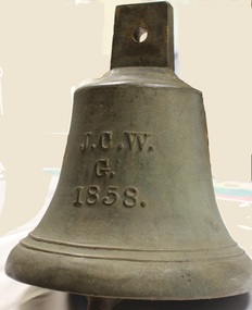
Functional object - Gordon Family Orchard Bell
The Gordons were architects and were associated with many buildings still standing in Albury and Wodonga, St Patrick's Church and the de Kerilleau Homestead among them. They established Vermont Orchard on 74 acres to the south of the Wodonga settlement. Here they grew fruit and nuts for the domestic and export market. The enterprising family also set about transforming some of the land by clearing it, creating streets and making general improvements. It was the biggest subdivision in Wodonga at the time. The 234 allotments in the Wodonga Estate were put up for sale by auction in May 1890. A total of 200 people were said to have attended. Gordon, William, Charles and Vermont streets in Wodonga are named after the family. This bell was used at the Vermont orchard to signal the beginning and end of the working day, as well as lunch breaks.The Gordon Family orchard bell is made of cast iron. It includes the inscription "J. C. W../G./1858." This is thought to represent the initials of John Gordon and sons Walter Joseph and Charles Goodwin Sylvester Gordon. There is some conjecture about this due to the date "1858". John was born in London, England in 1823 and died in 1880. Walter is generally accepted to have been born in 1857 and died 1903. In one family tree Charles is recorded as being born on 28 January 1858 but his birth was registered in 1860. The mystery of the date is therefore not fully resolved.On one side of the bell "J. C. W../G./1858."gordon family wodonga, gordon and gordon architects, vermont wodonga -
 Wodonga & District Historical Society Inc
Tool - Shearing Hand Set
The wool industry has been critical to the Australian economy from the early days of European settlement. The increase in wool production in the mid to late 19th century led to the need to replace the hand shears with some mechanized forms of shearing.The first commercially successful sheep shearing machinery by Frederick York Wolseley in New South Wales who was granted a patent for his machine on 28 March 1877. Many of the early settlers to North East Victoria droved sheep overland from both Sydney and South Australia and established large pastoral runs in the district. Wodonga became a major service centre for the industry and established major saleyards for the pastoral and cattle industries. The handset has the company name "Heiniger" on the side. Heiniger is a Swiss company with subsidiaries in Australia and New Zealand. It was originally established in 1946.This item is connected to a major rural industry in North East Victoria.A metal handpiece for a sheep shearing. A toothed blade is held in place with metal adjustable screws at one end. A jointed metal pipe at the other end allows attachment to the shearing machine. The hinge has been covered with leather.On adjustment knob "Heinger"shearing industry, shearing equipment, shearing handset -
 Eltham District Historical Society Inc
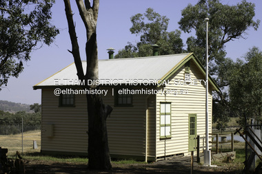
Photograph - Digital Photograph, Alan King, Yarrambat Heritage Museum, 23 January 2008
Original Yarrambat Primary School building at the Yarrambat Heritage Museum, Yarrambat Park. At the museum, visitors can gain an insight into Yarrambat’s past since non-Aboriginal settlement. The museum includes the original Yarrambat Primary School, which was moved to the site in 2000 and now serves as the Yarrambat Historical Society headquarters.The museum also includes a fully operational battery (gold-bearing ore crusher) driven by a McDonald 30HP diesel engine built in Richmond in 1938. The battery was relocated from the Golden King Mine in North Oatlands Road, Yarrambat, where it operated until 1984.1 Other exhibits include farming implements and machinery from the Yarrambat district. Published: Nillumbik Now and Then / Marguerite Marshall 2008; photographs Alan King with Marguerite Marshall.; p25This collection of almost 130 photos about places and people within the Shire of Nillumbik, an urban and rural municipality in Melbourne's north, contributes to an understanding of the history of the Shire. Published in 2008 immediately prior to the Black Saturday bushfires of February 7, 2009, it documents sites that were impacted, and in some cases destroyed by the fires. It includes photographs taken especially for the publication, creating a unique time capsule representing the Shire in the early 21st century. It remains the most recent comprehenesive publication devoted to the Shire's history connecting local residents to the past. nillumbik now and then (marshall-king) collection, yarrambat heritage museum, yarrambat historical society, yarrambat primary school -
 Sunbury Family History and Heritage Society Inc.
Photograph, Sunbury & District Heritage Association Inc, Vineyards Exhibition, August 1996
The vineyards exhibition was mounted by the Sunbury & District Heritage Association in the former George Evans Museum from August 1996 to January 1997. It featured the establishment of the vineyards and the wine industry in Sunbury from the 1860s to the present day. From the early days of European settlement in Sunbury, it was found that the soils and climate suited the growing of grapes, especially the east facing slopes along Vineyard Road. A number of people of German origin established vineyards along there. By the end of the nineteenth century and limited spending power as a result of the 1890s depression, the demand for wine declined in Victoria with beer being the preferred beverage.While Phylloxera destroyed the vines in many areas of Victoria, Sunbury's grapevines were not affected. As the demand for wine increased in the 1960s - 70s, some vineyards in the Sunbury area were replanted.The vineyards established in Sunbury in the 1860s were one of the earliest agricultural pursuits taken up by European settlers in the area and remained an important industry for 40 years.A non-digital coloured photograph of a display board advertising an exhibition of vineyards in the Sunbury area.vineyards, sunbury, vignerons, wine production -
 Stawell Historical Society Inc
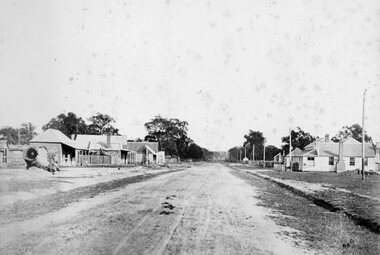
Photograph, Great Western 1866
Great Western. Part of a collection of Photographs by Mr. O.G. Armstrong as commissioned by the Shire of Stawell for the Inter-colonial and Paris Exhibition in Melbourne in 1866. Great Western began as a changing station on Concongella, northeast of the present Township. The gold rush in Great Western began in 1858 and soon after a post office and store opened. A Township was surveyed and lots sold in October 1858. The gold soon passed and the diggers went on, leaving a small settlement. In 1863 Jean Pierre Trouette and Emile Bampied, his brother-in-law, planted the first vines and build the first winery, thus setting a firm foundation upon which the present wine industry has been built. Telegraph poles and wires visible. Bakery visible in distance on right of road, looking west. stawell -
 Mt Dandenong & District Historical Society Inc.
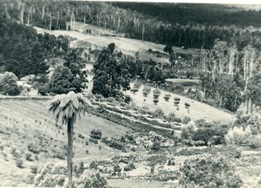
Photograph, The Valley of the Harmony Vale Settlement c1910, 1973
Scene looking across the valley of Harmony Vale from Barbers Road. c1910. Photograph copied by John Lundy-Clarke in 1973. This photograph has a detailed inscription on the back handwritten by John Lundy-Clarke in 1974.The valley of the Harmony Vale settlement on the Olinda Creek from Barbers Road. "Shiloah" on far left centre. John William Richardson's home among trees left of centre. Homestead Harmony Vale above log yard (see below) and among orchard trees. Child Bros sawmill and log yard with logs among trees above flat cultivation right of centre. Bert Childs home beyond "Harmony Vale". Lucas' "Glenrivers" is in gully above main clearing centre top left. Frank Childs home among trees centre of picture. Taken about 1910 by Rose Series. Copied 1974 JLC.kalorama, harmony vale, olinda creek, barbers road, shiloah, sawmill, child, bert child, glenrivers -
 Eltham District Historical Society Inc
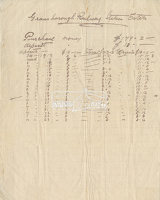
Document - Folder, Greensborough Railway Station Estate, Lots 26, 26A and 26B, Crown Portion 3, Parish of Nillumbik, County of Evelyn (Rattray Road, Montmorency)
Crown Portion 3 of Eltham, Parish of Nillumbik, County of Evelyn, Lots 26, 26A and 26B were part of the Greensborough Railway Station Estate. The land detailed is bounded by present-day Rattray Road, Reichelt Avenue, Wooded Way and Ryrie Court, Montmorency. Originally purchased in September 1913 by George William Miller, signwriter of Greensborough and Harry Frederick Miller, the land was sold to Mrs Margaret Barr Honeyman, 24 June 1918 on mortgage for £400, deposit paid £150. In February 1920, Mr Honeyman called for the title and paid off the loan early, settlement occuring 11 October 1920. Contents: 1. Handwritten payment plan (Sep 1913 to Mar 1923) for Lots 26, 26A and 26B being parts of Crown Portion 3, Parish of Nillumbik, County of Evelyn on the plan of subdivision making up the Greensborough Railway Station Estate situated on Rattray Road; purchased for £179.2.0 with a deposit of £18.0.0. 2. Receipt: From Messrs G.W. and H.F. Miller for £11.15.8 being instalment and interest, 9 Sep 1913 3. Invoice: To Messrs G.W. and H.F. Miller for £11.12.0 being instalment and interest due 15 Sep 1914 4. Contract of Sale: George William Miller and Harry Frederick Miller to Mrs. Margaret Barr Honeyman, in respect of sale of Lots 26, 26A and 26B for £400.0.0, 24 June 1918. Deposit of £150.0.0 balance to be paid half yearly instalments of £15 with interest at 5% per annum added. 5. Letter: Percy J. Russell, Solicitor to G.W. Miller, 5 Feb 1920 advising Mr Honeyman has called for the title and wishes to pay off mortgage. 6. Letter: Percy J. Russell, Solicitor to G.W. Miller, 11 Oct 1920 advising settlement and payment of Miller to Honeyman.contract of sale, george william miller, greensborough railway station estate, harry frederick miller, land sale, margaret barr honeyman, montmorency, rattray road, reichelt avenue, ryrie court, wooded way -
 The Beechworth Burke Museum
Photograph, Unknown c.1900s
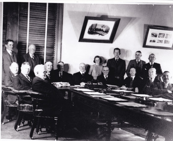
This image depicts a group of local counsellors from the Shire of Beechworth (est. mid to late 1900s). The identities of those within the photo remain unknown. The table and chairs featured in the image were produced in the late 19th century and have been in continual use for more than 100 years. The councellors would likely have convened in the Beechworth Town Hall. A History of Beechworth: Gold was discovered in the May Day Hills district in 1852. A canvas and timber settlement soon developed as prospectors rushed to the area. Over four million ounces of gold was recovered in the first 14 years. Between 1852 and 1857, Beechworth was a gold-producing region and centre of government, boasting many industries and a multicultural population. Beechworth was proclaimed a borough on the 11th of September 1863, a formalisation of the municipal incorporation of the town seven years before. This image is associated with the history of Beechworth; it reveals the identities of local counsellors, persons whose contribution to the Beechworth Shire could otherwise be lost to time. Black and white rectangular photograph, unmounted.beechworth council, indigo shire, local victorian government -
 Orbost & District Historical Society
black and white photograph, late 19th century - early 20th century
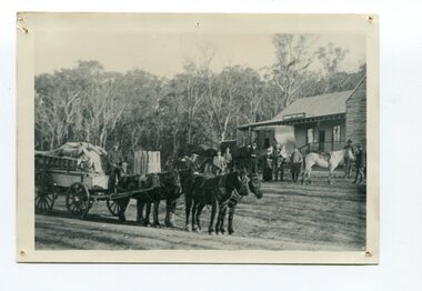
This is a photograph of Alice Swallow's hotel at Cabbage Tree. The settlement of Cabbage Tree Creek is located on the Princes Highway, 27 km east of Orbost in East Gippsland. The first white settler arrived in the valley in 1887 cutting a dray track from Marlo to the south-west. Several families cleared the alluvial flats, growing maize, peas and beans and raising pigs, cattle and sheep. Later the farmers milked cows, sending cream to Orbost. In the late 1890s, small quantities of alluvial gold were found in the creek. A school commenced classes in 1913, but enrolment was small and at times the school operated part time with several other small schools in the area. The school building served as a hall for the district. From the 1920s the Cabbage Tree Hotel catered to drivers on the improved Princes Highway. (info. from Victorian Places)This is a pictorial record of Cabbage Tree, East Gippsland in the late 20th century. It shows a building that no longer exists.A black / white photograph of a small, single - storey wooden building in a bush setting. There are people standing in front of the building with a horse and wagon nearby. In the foreground is a wagon with four horses hitched to it and the driver seated behind the horses. -
 Orbost & District Historical Society
black and white photograph, first half 20th century
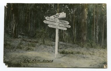
Prior to the sealing of the Princes Highway west of Orbost, the road surface was anything but good, even by C1917 when cars started to use the road. From Orbost the old road via Marlo to Sydenham was abandoned for the new location which traversed more rugged country via Cabbage Tree, Bell Bird and Club Terrace to Cann River, and the reason for this diversion was on account of settlements being established at Murrungowar and Club Terrace, at which latter place there was a temporary rush to obtain gold. This road was constructed by the Public Works department and a maximum grade of 1 in 19 was adopted, and as speed was not to be catered for the grade followed in and out round the spurs and gullies, resulting in a maze of turns and twists which required a good deal of skill on the part of the horse driver to negotiate." - Bairnsdale Advertiser, Friday, May 2, 1947. (More information from Newsletter February 2010)This is a pictorial record of an early road distance sign on a major highway through East Gippsland. The distances are indicated in miles, a measurement standard no longer in use.A black / white photograph postcard of the signpost at the Victorian - New South Wales border. It shows distances to Sydney and Eden on one arrow and distances to Melbourne and Genoa on another. on front - Vic - NSW Borderprinces-highway-east-gippsland road-transport road-sign -
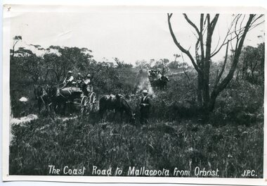 Orbost & District Historical Society
black and white photograph, late 19th century - early 20th century
Prior to the sealing of the Princes Highway west of Orbost, the road surface was anything but good, even by C1917 when cars started to use the road. From Orbost the old road via Marlo to Sydenham was abandoned for the new location which traversed more rugged country via Cabbage Tree, Bell Bird and Club Terrace to Cann River, and the reason for this diversion was on account of settlements being established at Murrungowar and Club Terrace, at which latter place there was a temporary rush to obtain gold. This road was constructed by the Public Works department and a maximum grade of 1 in 19 was adopted, and as speed was not to be catered for the grade followed in and out round the spurs and gullies, resulting in a maze of turns and twists which required a good deal of skill on the part of the horse driver to negotiate." - Bairnsdale Advertiser, Friday, May 2, 1947. (More information from Newsletter February 2010)n the late 1800's early 1900's transporting goods by road was difficult and at times impossible because roads as thoroughfares did not exist.The means of travelling along the roads in the 1800's was by bullock wagon, horse pulled dray, pack horse or simply by foot. This road is still in use in East Gippsland as a part of many four-wheel-drive touring routes.A large black / white photograph of two horse - drawn wagons on a narrow sandy bush track. It is surrounded by scrub. There is one man standing beside a horse not harnessed to a wagon.on front - "The Coast Road to Mallacoota from Orbost JPC" -
 Warrnambool and District Historical Society Inc.
Letter, Hand written copy National Bank V A Bostock, Circa 1900
Augustus Bostock was the 9th child of Robert & Rachael Bostock of Vaucluse Epping Forest, Van Diemen’s Land. He was only 4 years old when his mother died. He was inspired by his father to seek his fortune in the Western District of Victoria. He arrived around 1850. He married Margaret Aitkin in July 1865. Augustus owned several properties in the district and leased others. He sat on the court of Warrnambool, Mortlake or Hexham as required. He resided at Marramook in Hawkesdale and later moved to Vaucluse in Hopetoun Road Warrnambool, where he died in 1920 at the age of 87. He was involved in many aspects of life in the Western District, racing, cricket, and social activities to name a few. This letter shows correspondence between the two firms of solicitors and is demanding payment of £500.00 as settlement by Bostock, to the National Bank. This is one of a number of documents which relate to the Bostock family who were one of the most important pioneering families of the Western District. They owned and leased various properties around Warrnambool and were involved in many aspects of social and business life. The document itself is indicative of its time and provides an insight into the details and terms of such documents at the time.Cream lined paper, with Solicitors letterhead printed in top left corner. Letter is hand written in black ink. Watermarked Cowan Extra strongKlingender, O’Mahony & Murray Solicitors at Warrnambool, Koroit, Port Fairy, Terang and Mortlake. Telephone No. 51. The letter has come from Malleson, England & Stewart of Melbourne. Watermarked Cowan Extra Strongwarrnambool, bostock, national bank, klingender, o’mahony, murray, malleson england and stewart,1900, -
 Eltham District Historical Society Inc
Photograph, Fay Bridge, Rosehill Homestead, EDHS Heritage Excursion, 6 July 2019
July Excursion July 6, 2019 - Exploring Lower Plenty The predominant feature of this walk in the Bonds Road area, Lower Plenty is the large number of magnificent old River Red Gums that line the route. These trees are of the spreading woodland form of this species indicating that they must have been originally growing in a reasonably open setting. The walk also includes parts of the historic Cleveland Estate and the homestead “Rosehill” established by pioneer farmer Henry Stooke. This area was the site of the first recorded European settlement in what was to become the Shire of Eltham when the Willis brothers arrived in the late 1830s. From the southern part of Cleveland Avenue there are extensive views across and along the Yarra Valley. An article on the history of this area was contained in Newsletter edition 201, November 2011. The walk will start at the at the corner of Bonds and Stawell Roads, Lower Plenty - EDHS Newsletter No. 246 June 2019fay bridge collection, 2019-07-06, blackburn bricks, eltham district historical society, heritage excursion, rosehill homestead, lower plenty -
 Eltham District Historical Society Inc
Document - Folder, Nixon, Bruce
Walter Bruce Nixon (20.11.1934-8.9.2012) lived at Yarra Glen and was a bus line owner. He also ran a company, Tarcoola Press, which published books on the history of the Nillumbik and Yarra Valley area, and generously supported organisations such as the Andrew Ross Museum and the C J La Trobe Society. Contents Newspaper article: "Revealed: the stark beauty of an early settlement", The Age, 19 November 1999, Bruce Nixon underwrote publication of a book of C J La Trobe's drawings and paintings of Melbourne. Newsletter extract: "Bruce Nixon: a boyhood in Ivanhoe", Heidelberg Historian No.270 June 2012, Bruce Nixon's memories of growing up in Ivanhoe from the 1930s and on Mick Woiwod's books. Order of Service: Walter Bruce Nixon, 14 September 2012. Flier: "Recent works by Mick Woiwod", notes the support provided by Bruce Nixon.Newspaper clippings, A4 photocopies, etcbruce nixon, charles joseph la trobe, tarcoola press, waterdale road ivanhoe, ivanhoe state school, knox church ivanhoe, ivanhoe swimming club, donaldson family of kangaroo ground, thomson family of kangaroo ground, james bruce donaldson, james thomas donaldson, john donaldson, wallace thomson, george donaldson, james williams bushranger, andrew ross, andrew ross museum, mick woiwod, wurundjeri people of kangaroo ground, coranderrk healesville, walter bruce nixon -
 Mt Dandenong & District Historical Society Inc.
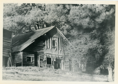
Photograph, Isaac Jeeves' Barn
Large barn built c1886 by Isaac Jeeves the younger on his property where the homestead 'Shiloah' stood. The barn was reputedly made from timbers split from only one messmate tree. Originally the home of Isaac Jeeves, brother of Ellis Jeeves, ‘Shiloah’ was enlarged to take guests in the early 1900s. It was situated close to a beautiful fern gully and Isaac and his family capitalised on this by setting out walking tracks through the ferns. They charged 1/- to walk through and this included afternoon tea in a garden setting. ‘Shiloah’ was a popular tourist attraction but the making of the Olinda Creek Road destroyed the fern gullies and, by the 1930s, it was all finished. John Lundy-Clarke grew up in the Kalorama/Mt Dandenong area and later in life (1972-74) began to write a comprehensive history of the area working from an original settlement map in an effort to cover all areas.Black and white photograph showing a large wooden structure surrounded by trees. Handwritten inscription on reverse by John Lundy-Clarke.Home of Isaac Jeeves the younger. Built about 1886 of timbers split from one messmate tree. Photo 1973isaac jeeves the younger, barn, kalorama, shiloah, messmate -
 Mt Dandenong & District Historical Society Inc.
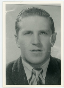
Photograph, Alan Price
John Lundy-Clarke grew up in the Kalorama/Mt Dandenong area and later in life (1972-74) began to write a comprehensive history of the district working from an original settlement map in an effort to cover all areas. Alan Price was the son of Edward John Price and Myra (nee Wilson) Price. He had a brother Edward Joseph 2nd (Teddie). Alan and Teddie were the grandsons of early settlers Edward Joseph and Annie (nee Ross) Price. Alan Price worked at his brother's depot in Ringwood, in charge of mechanical equipment. He rode to and from work on his motorbike. Alan was killed in a motorbike accident on his way home from work in 1971. Alan married Patricia Guerin in 1960. They had five daughters and one son. The family had a house on part of Lot 5 facing Mt Dandenong Road.Black and white close up of man in suit and tie. Reverse of photograph has handwritten description by John Lundy-Clarke. Alan Price 1969. Son of Edward John Price and Myra nee Wilson. alan price, patricia guerin, edward joseph (teddie) price, edward john price, myra price, myra wilson, edward joseph price, annie price, annie ross, kalorama, accident -
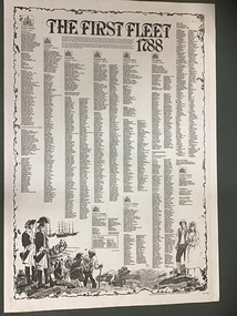 Queenscliffe Maritime Museum
Poster - Copy of Poster listing The First Fleet 1788 passenger lists
The First Fleet comprised the 11 ships that departed from Portsmouth, England on 13 May 1787 to New South Wales, the penal colony that became the first European settlement in Australia. The First Fleet consisted of two Royal Navy vessels, three store ships and six convict transports, carrying between 1,000 and 1,500 convicts, marines, seamen, civil officers and free people (accounts differ on the numbers), and a large quantity of stores. From England, the Fleet sailed south-west to Rio de Janeiro, then east to Cape Town and via the Great Southern Ocean to Botany Bay (Australia), arriving over the period of 18–20 January 1788, taking 250 to 252 days from departure to final arrival. During the period 25–26 January 1788 the fleet moved from Botany Bay to present-day Sydney.A poster listing the names of men and women who landed with the first fleet including provisions and livestockThe First Fleet 1788the first fleet, botany bay, sydney -
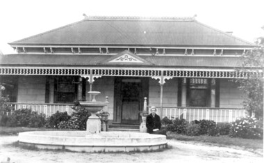 Surrey Hills Historical Society Collection
Photo, 'Spenceycroft', Canterbury Road
The photo is of ‘Spenceycroft’ at 654 Canterbury Road, Surrey Hills. For many years this home was hidden behind a large fence sheltering it from the noise of traffic along Canterbury Road, however it dates back to the very early days of settlement in the Surrey Hills area. Canterbury Road was then known as Delany’s Road. ‘Spenceycroft’ is thought to incorporate part of the original farmhouse built on the site by George Klepper, who planted a vineyard in the area. George’s family was one of a number of German families who settled in Surrey Hills during the later part of the 19th century. Later, the land associated with ‘Spenceycroft’ was worked as a dairy farm by James and Elizabeth Rayment. In recent years 'Spenceycroft' has been sold several times and has become increasingly derelict. Sold again in 2015 when it had become quite derelict, it was demolished and re-developed.A black & white photo of double-fronted Victorian style home with a fountain centre front and low foliage in front of the veranda. A woman is sitting by the fountain. 'spenceycroft', canterbury road, james rayment, elizabeth rayment, george klepper -
 Phillip Island and District Historical Society Inc.
Photographs, mid 2008
A collection of photographs donated by Meg Davis (nee McHaffie) relating to the Lonely Grave site in Ventnor and the McHaffie family.A collection of 8 coloured photographs relating to Capt. Grossard's Grave Site and the McHaffie family. 272-01. Photograph of Fiona McCarthy and Julie Box planting a Norfolk Pine at the Lonely Grave, Grossard Point, Ventnor, Phillip Island 272-02. Photograph of Fiona McCarthy and Meg Davis planting a Norfolk Pine at the Lonely Grave, Grossard Point, Ventnor, Phillip Island 272-03. Photograph of the Lonely Grave Memorial Plaque re Capt Grossard's accidental death. 272-04. Photograph of a Memoral Plaque commemorating the first settlement on Phillip Island by the McHaffie family 272-05. Photograph closeup of the above Memoral Plaque. 272-06. Photograph of the Memorial Plaque of the Gravesite of Capt. W. P. Grossard who died 17th December 1868. 272-07. Photograph closeup of the above. 272-08. Photograph of a brown glazed pot supposed to be from the McHaffie homestead site in Ventnor, Phillip Island.capt grossard, the lonely grave at grossard point, mchaffie family, meg davis, julie box, fiona mccarthy -
Victorian Aboriginal Corporation for Languages
DVD, Suzy Bates, Nothing rhymes with Ngapartji, 2010
Nothing Rhymes with Ngapartji follows the journey of acclaimed Pitjantjatjara actor Trevor Jamieson, as he returns to his traditional country to perform his hit stage show Ngapartji Ngapartji to an all-Indigenous audience in the remote Australian Aboriginal community of Ernabella, South Australia. Nothing Rhymes with Ngapartji is a film about performing a multi-faceted drama to audiences who speak different languages, who are of different cultures and who have varying expectations. Offers an insight into Indigenous perspectives on the consequences of white settlement for Aboriginal cultures. In presenting the material in both Pitjantjatjara and English, it raises the important issue of stories needing to be told in languages that are central to different Australians' understanding of the world. The film is part of Big hART?s Ngapartji Ngapartji project, which is a collaborative work in progress between Indigenous and white Australians that pools their skills, experiences and resources to tell an important story about Indigenous history, culture, language and the experience of several generations.DVD, online study guidepitjantjatjara, theatre, music performance, big hart -
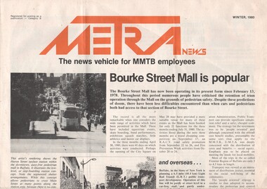 Ballarat Tramway Museum
Magazine, Melbourne and Metropolitan Tramways Board (MMTB), "Metra News - Winter 1980", 1980
Single sheet of paper, folded to from a four page newsletter, titled "METRA News, the news vehicle for MMTB employees" and dated Winter 1980. Has the title printed in red ink and uses the same colour for other titles for items with the newssheet.. Items of interest: 1. Bourke St. Mall 2. Senior citizens help design new tram - Z3 class trams 3. Bus only lane in Johnston Street 4. Education of City Police 5. An extensive item on people, new employees, promotions - including the promotion of BTM Board Member Greg Rodgers to Trainer Drivers at Camberwell. A number of these people have been underlined or circled in red ink. 6. Depot employees' social and facility fund 7. Profile on R.C.Dummond, Traffic Manager 8. Wilbur's corner - a review of out of court settlements for accidents. 9. Two cartoons by AugustineRed ink circling or underling specific employee names in the people section.trams, tramways, mmtb, bourke st, bus only lane, accidents -
 Kew Historical Society Inc
Plan - Subdivision Plan, Normanby Heights Estate, Kew, 1919
Prue Sanderson, in her groundbreaking ‘City of Kew Urban Conservation Study : Volume 2 - Development History’ (1988), summarised the periods of urban development and subdivisions of land in Kew. The periods that she identified included 1845-1880, 1880-1893, 1893-1921, 1921-1933, 1933-1943, and Post-War Development. These periods were selected as they represented periods of rapid growth or decline in urban development. An obvious starting point for Sanderson’s groupings involved population growth and the associated economic cycles. These cycles also highlighted urban expansion onto land that was predominantly rural, although in other cases it represented the decline and breakup of large estates. A number of the plans in the Kew Historical Society’s collection can also be found in other collections, such as those of the State Library of Victoria and the Boroondara Library Service. A number are however unique to the collection.The Kew Historical Society collection includes almost 100 subdivision plans pertaining to suburbs of the City of Melbourne. Most of these are of Kew, Kew East or Studley Park, although a smaller number are plans of Camberwell, Deepdene, Balwyn and Hawthorn. It is believed that the majority of the plans were gifted to the Society by persons connected with the real estate firm - J. R. Mathers and McMillan, 136 Cotham Road, Kew. The Plans in the collection are rarely in pristine form, being working plans on which the agent would write notes and record lots sold and the prices of these. The subdivision plans are historically significant examples of the growth of urban Melbourne from the beginning of the 20th Century up until the 1980s. A number of the plans are double-sided and often include a photograph on the reverse. A number of the latter are by noted photographers such as J.E. Barnes.The Normanby Heights Estate not unusually used hyperbole to attract purchasers to the auction of 17 lots facing Argyle Street (sic), Pleasant Avenue and Normanby Road. Predictably factors appealed to included the proximity to schools etc, the availability of public utilities, friable soil, picturesque views and ‘advancing settlement’. If that were not enough, the sales pitch exhorted prospective purchasers to consider their backbone. ‘Thrift is unquestionably the Backbone of any Nation. No better form of Thrift can be encouraged in the young citizen than by investing his or her savings in a piece of land in a growing, healthy and beautiful locality. NORMANBY HEIGHTS ESTATE admirably fits the need.’ The experience of Australia at war undoubtedly contributed to the use of terms such as ‘Backbone of a Nation’ and the appeal to egalitarian principles in the choice of the term ‘young citizen’. The recognition that women had savings and might be the prospective purchaser also reflects a new sense of the rights and entitlements of women in the postwar period.subdivision plans - kew, normanby heights estate, pleasant avenue, normanby road, argyle street -
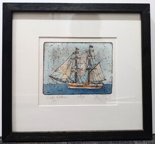 Glenelg Shire Council Cultural Collection
Artwork, other, BRIGIT THOMAS, Lady Nelson, c. 2015
From - theladynelson.org.au T The original Lady Nelson was built at Deptford, in England, in 1799, for service to the Transport Office on the River Thames. She was designed with sliding keels (centre boards), a device invented by Captain John Schank of the Royal Navy to allow surveying in rivers and shallow water ways. On completion she was selected for exploration services in the Colony of New South Wales and sailed for Port Jackson on 18 March 1800 under the command of Lieutenant James Grant. A brig of 60 tons, she carried a crew comprising the commander, two mates and twelve seaman. As she left the River Thames sailors on nearby ships ridiculed her because of her size and shape, calling her, as she sailed past, 'His Majesty's Tinderbox'. At Portsmouth on the 9th February 1800 she was fitted with four brass carriage guns, three to four pounders, in addition to the two guns already on board. Because of the heavy load she was carrying she was very low in the water, having only two feet nine inches freeboard amidships. The ship finally left Portsmouth on 17th March 1800 as part of an East Indian Convoy. From 1800 to 1825 the Lady Nelson operated around the Australian Coast and fulfilled a variety of roles including exploration, surveying, forming settlements, shifting goods and people around the colonies and capturing pirates. She played pivotal roles in the European settlement of Hobart, Northern Tasmania, Melbourne, Newcastle, Port Macquarie and Northern Territory. Those onboard charted much of Bass Strait, Port Philip, Newcastle, Port Macquarie and (with the Investigator) the coasts of northern New South Wales and southern Queensland. She also has links to other locations around the East Coast such as Trial Bay in NSW and the Mt Gambier area of SA. After 25 years of service while trading on the island of Baba the Lady Nelson was overrun by the islanders, the crew was killed and the ship stripped and later burnt and sunk. A replica of the Lady Nelson was built in the 1980s.Image of a tall ship in sail. The ship is flying both the Aboriginal flag and the Australian Flag. It sails on a calm sea. There are figures on the deck - four in total. The image is mounted on cream board and framed in dark timber. Etching, hand coloured,.Front: 'Lady Nelson A/P BT' - hand written, pencil in between etching and mount Back: Artist's business card glued to back of etching, lower left hand corner:ady nelson, femal artists, female artist, women -
 Glenelg Shire Council Cultural Collection
Painting, Robert Ulmann, Goat, c. 1974
Robert Ulmann was born in Zurich, Switzerland, where he studied sculpture and painting, exhibiting annually with the National Art Society of Switzerland and in Paris, Munich and Stockholm. He migrated to Canada in 1956 and became a Canadian citizen. After working on the restoration of sculpture on the west wing of the Parliament Buildings Ottawa, he took up a Government appointment as one of six artist advisers to the Eskimos, initiating handicraft and sculpture programs in isolated settlements across the Central Arctic. He arrived in Australia with his Australian wife, Helen, in 1969, after two adventurous years backpacking and sketching through the United States, Central and South America and the South Pacific. From 1970 to 1972 he was employed by the Northern Territory Administration as a manual arts instructor to the aboriginal people of Docker River, a remote settlement west of Ayers Rock. A series of drawings from this period was exhibited by the Department of the Interior in Canberra, Sydney and Adelaide. Robert Ulmann’s paintings and prints of wildlife from Australia and overseas fill a beautiful studio overlooking the famous Logans Beach whale nursery at Warrnambool in the Western District of Victoria. His previous studio and home, together with 13 years of field sketches and his best work collected together for two books were destroyed by the Ash Wednesday fires at Naringal in 1983. Rob exhibited in Sydney, Melbourne, Adelaide and Perth as well as in the Regional Galleries of Warrnambool, Ballarat, Portland and Horsham, and, among numerous prizes, he won the award for watercolour at six of the annual exhibitions of the Wildlife Art Society of Australasia, between 1978 and 1983. Although his principal interest was in drawing and painting, he retained a fascination with sculpture. His works range from two stone fountains with figures commissioned by the City of Zurich, while he was still a student, to a 4 ½ ton sculpture in bluestone commissioned in 1977 as a memorial to Sir Fletcher Jones., a five metre representation of whale tails in steel, and a life-size bronze of St. John of God commissioned for a private hospital.Image of a goat beginning to rise from a seated position, possible struggling out of mud. Painted in yellow and brown tones, with blue shadows. Earth colours form a rough ground area surrounding the goat. A brown wash provides a cursory background behind the goat's head. Dark cream matt surrounds image. Gold painted wooden frame, with glass.Front: Robert Ulmann (lower centre, paint) Back: (no inscriptions) -
 Orbost & District Historical Society
black and white photograph, 1918
Tonghi Creek is 66km north - west of Orbost. Prior to the sealing of the Princes Highway west of Orbost, the road surface was anything but good, even by C1917 when cars started to use the road. From Orbost the old road via Marlo to Sydenham was abandoned for the new location which traversed more rugged country via Cabbage Tree, Bell Bird and Club Terrace to Cann River, and the reason for this diversion was on account of settlements being established at Murrungowar and Club Terrace, at which latter place there was a temporary rush to obtain gold. This road was constructed by the Public Works department and a maximum grade of 1 in 19 was adopted, and as speed was not to be catered for the grade followed in and out round the spurs and gullies, resulting in a maze of turns and twists which required a good deal of skill on the part of the horse driver to negotiate." - Bairnsdale Advertiser, Friday, May 2, 1947. (More information from Newsletter February 2010)This item is a pictorial record of roads in the early 20th century in East Gippsland.A large black / white photograph of a bridge over a small creek, surrounded by bush. The photograph is mounted on a thick cream coloured card.on back - "Bridge at Tonghi Creek 1918"tonghi-creek-bridge country-roads-east-gippsland -
 The Beechworth Burke Museum
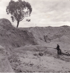
Photograph
This photograph depicts a man in dark clothing, standing in front of a cut away section of earth. He is undertaking hydraulic sluicing, which involves the use of high powered hoses, in order to cut away the earth which can then be sifted for gold. There is a single tree in the background and the earth contains numerous signs of damage because of the mining. Beechworth become a mining settlement after the discovery of gold in 1852. Gold fever had already spread across Australia's colonies and the American states. Sluicing the landscape for gold, as shown in this photograph, was done by diverting water and washing away the lighter dirt, allowing the gold particles to sift down in to catchments for collection. In Beechworth, there was considerable discontent caused by attempts to restrict water use for sluicing to those with certain 'water rights'. The extensive use of hydraulic sluicing, and the washing away of top soils has continued to impact the surrounds of Beechworth in to the present day. Sluicing as a method for gold mining which was widespread across Victoria during the 1870s. The erosion of the top soil in search of gold has a continuing environmental impact on the landscape and this photograph depicts but one example of this occurring and can provide much information to a researcher interested in understanding the history of gold mining in Victoria. This image of the miner and hose is historically important because it demonstrates the methods of goldmining employed in the later years of the goldrush at Beechworth. It shows how much land is washed away by the use of this technology. The image has good interpretive capacity because it allows researchers to see a different mining technique to what is usually presented. Black and white square photograph on card.reverse: 84-50-3 / 1997 3141 / smdsluicing, goldmining, beechworth, burke museum, miners, gold miners, gold sluicing, environmental impact -
Warrnambool and District Historical Society Inc.
Document, Wollaston sale, 1919
This is a poster advertising the sale of part of the Wollaston Estate in Warrnambool in 1919. The sections for sale were Allotments 1, 18 and 19 which included the Wollaston Homestead. The original Wollaston property of 679 acres was selected by Thomas Manifold in the late 1840s. This land, on the northern side of the Merri River, near the Woodford Road was three kilometres from the Warrnambool town. The first farmer we know who leased the property was William Simpson. Walter Manifold inherited the property and he took it over in 1884. The swing bridge he built in 1890 still stands today. In 1919 the Closer Settlement Board of Victoria acquired Wollaston and 17 lots were sold to returned soldiers for farming purposes. By 1930 there were only five soldier settlers remaining. In 2009 further subdivision took place with lots sold for residential purposes. The homestead allotments were sold separately in 1919 with various owners of the homestead itself recorded since that time. This poster is of interest as it shows the areas of the Wollaston Estate which were sold in 1919. The history of this estate is well-documented and of importance in the history of Warrnambool. This is a sheet of paper with red and black printing and a map of the Wollaston Estate which is photo-lithographed. The sheet has been folded three times. It has some small tears at the top of the page. wollaston, history of warrnambool, walter manifold -
 Kiewa Valley Historical Society
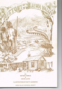
Book - A History of the Kiewa Valley, Kiewa Valley Historical Society, A History of the Kiewa Valley by Esther Temple and David Lloyd, Circa 1991
This book was compiled by Esther Temple and David Lloyd with illustrations by Betty Barberis and additional material provided by Clare Roper, Joan Macdonald, Wilma Davies and Nell Bateman. The book was first penned in 1971. It briefly covers the period from the indigenous tribes(broken down into family groupings) known as the "first Australians" who lived in the valley well before English settlers arrived. first white settlement (graziers, miners, stockmen) to smaller settlements.The development or transformation from a pristine(hunter/gatherer) valley environment to one that has been gradually changing to a more commercial rural/industrial landscaped valley. This transformation was made within a time span of two hundred years. The book details the first pioneers and their descendants, along with the changes to their environments both domestic and commercial. The book highlights dates and events that shaped the "feel" of the valley. The extreme hardships faced by pioneer families during the extremely isolated times away from "civilisation".This publication provides an insight to the struggles and victories against the harsh Australian bushland by people who had not been raised in such a sometimes inhospitable environment. It was this transformation which instilled into the Australian psyche of self sufficiency and the ability to grasp onto ideas or "bush" remedies to overcome enormous difficulties. It is is ability that has produced the many inventions useful in the 20th and 21st centuries.This book has a 250 g/m cream coloured cover with print and drawings of rural aspects of historical significance ( Aboriginal and early white settlers). The book contains 124 pages of black and white photographs(139), black and white sketches(75), two pages of sketches and freehand drawings, two freehand maps one county lease /subdivision plan and black and white printing. See KVHS 0237 (B) for the official invitation to the launch of the book.The front top cover heading(in shaded print and enclosed in a banner form) "A HISTORY OF THE KIEWA VALLEY" The bottom printing "BY ESTHER TEMPLE & DAVID LLOYD ILLUSTRATIONS BY BETTY BARBERIS" and at the very bottom "KIEWA VALLEY HISTORICAL SOCIETY" oN THE BOOK SPINE "A HISTORY OF THE KIEWA VALLEY.....BY ESTHER TEMPLE & DAVID LLOYD"early settlers, dederang, tawonga, mount beauty, sec vic hydro electricity, falls creek early settlers, bonegilla -
 Warrnambool and District Historical Society Inc.
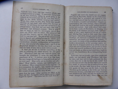
Book, Divine Conduct or the Mystery of Providence, Early to mid 19th century
This is a book, ‘Divine Conduct or the Mystery of Providence’ originally written by the Rev. John Flavel in 1677. This is a later edition with no date listed but it is presumed it was re-published in the 19th century. The book was given to Janet McGhie in 1849, the first anniversary of the Warrnambool Sunday School, just 14 months after the first European settlers arrived in the new settlement of Warrnambool. The first Sunday School in Warrnambool was located in McDowell’s Store and run by Thomas Denney and Richard Osburne. The latter in 1851 commenced Warrnambool’s first newspaper, the Warrnambol Examiner and in 1887 published an important history of Warrnambool. Janet Garden McGhie was the daughter of Matthew and Isabella McGhie who were pioneer settlers in Warrnambool. Janet McGhie married Alfred Coulstock at the age of 17 and died in Warrnambool in 1918 at the age of 80. She was aged 11 when she received this book and one wonders what she made of the ponderous text. This book is very precious as one of the few mementos we have of the very early days of Warrnambool’s settlement. It gives us a date for the establishment of the first Sunday School and the name of one of the award winners. It is also an interesting example of the pious and ponderous writings that young children were expected to read in the mid 19th century. It is presumed that at that time there would not have been a great choice of reading material available in Warrnambool to give to childrenThis is a hard cover book of 252 pages. The dark green cover has gold lettering on the spine which is almost obliterated. The cover is partly detached from its binding and is much stained and blotched. There is an inscription on the inside front cover in black ink and a red stamp of the Warrnambool & District Historical Society on the first page. There are some indecipherable pencil markings on this first page and the last page.‘Janet McGhee (or McGhie), 1st Anniversary Warrnambool Sunday School, Decr 3rd 1849’janet mcghie, warrnambool sunday school -
 Orbost & District Historical Society
programs, 1961
The Snowy River Shire was a local government area in the Australian Alps region of New South Wales, Australia from 1939 until May 2016. It was named after the Snowy River that runs through it. Prior to 1936, it had been named as Dalgety Shire since establishment in 1906. This opening of the Monaro - Gippsland Road took place on 4th May 1961. There had long been a movement in Monaro for the construction of a road to connect Monaro and Gippsland, via Inglebyra and Black Mountain. The only track was for stock, made by pioneers many years ago, and it was very circuitous. It was stated at a meeting at Dalgety that the road would open up large areas for settlement for grazing, and for timber suitable for bridgé building. The road would assist stock deal ing between Monaro and Gippsland. It would also considerably shorten the distance from Victoria for tourists visiting Canberra and Kosciusko. A committee was formed to put the proposal before the Dalgety Shire Council in the 1930s.This item is a useful research tool.Four copies of a road opening program. It has black print on white. There are black / white photographs, historical details and details of the official opening.program monaro-road snowy-river-shire