Showing 7074 items
matching significance
-
 Bendigo Historical Society Inc.
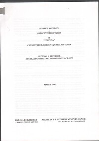
Document - Pompeii Fountain & Adjacent Structures at "Fortuna"
Fortuna Villa was initially commenced as a modest single storey home in 1861 next to the 180 Mine by Theodore Ballerstedt, who sold the mine and house to George Lansell in 1869. Lansell already owned the adjacent Fortuna Mine, and through deeper mining techniques greatly expanded the mine's operation, his personal wealth, and the house and grounds. Lansell was soon known as the 'Quartz King', Australia's first gold mining millionaire and credited as the driving force behind much of Bendigo's prosperity. He continuously added to and expanded the villa, decorating it extravagantly with the finest of artworks and materials, into a sprawling mansion with extensive landscaped grounds, to create a house and grounds of a size and grandeur with few rivals in Australia. After his death in 1907, his second wife Edith carried on with improvements, creating a house and grounds developed over 50 years. The attached mine also contributes to its significance, being one of the richest mines in Bendigo, and at one stage probably the deepest gold mine in the world at 3176 feet. The 1875 crushing works are attached directly to the mansion, and the mine's tailings and settling ponds (turned into ornamental lakes) represent a direct link between George Lansell's wealth and its source. Fortuna was compulsorily acquired by the Commonwealth in 1942 as the Cartographic Headquarters of the Australian Survey Corps during World War II, and many ancillary structures were added while preserving the main house and ornamental grounds. Victorian Heritage Database Report https://vhd.heritagecouncil.vic.gov.au/places/68334/download-reportConservation report for the Pompeii Fountain & Adjacent Structures at "Fortuna" Chum Street, Golden Square, Victoria. Prepared for Fortuna Historical Committee. March 1996.Halina Eckersley, Architect & Conservation Planner, Kewpompeii fountain, greenhouse, fortuna lake, gardens -
 The Beechworth Burke Museum
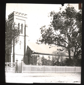
Photograph - Lantern Slide, c1900
Beechworth's Anglican Church, Christ Church St Peter and St Paul, has served the Beechworth community since 1858 in its present form, following its beginnings in a tent in 1855. The Victorian branch of the National Trust classified the building as regionally significant in 1959 and the organ as of significance to the nation in 1992. Building a place for Anglican worship was a priority in the early days of Beechworth's settlement as the town was a site of regional administration due to its association with the economic and social expansion of Victoria during the Gold Rush period. The Church garden features several significant trees monitored by the Beechworth Treescape Group, including a cork oak growing near the Ford Street entrance, an Atlantic cedar, a bunya or bunya-bunya pine and two kurrajongs. Some of these long-established trees may be visible in this lantern-slide image. Lantern slides, sometimes called 'magic lantern' slides, are glass plates on which an image has been secured for the purpose of projection. Glass slides were etched or hand-painted for this purpose from the Eighteenth Century but the process became more popular and accessible to the public with the development of photographic-emulsion slides used with a 'Magic Lantern' device in the mid-Nineteenth Century. Photographic lantern slides comprise a double-negative emulsion layer (forming a positive image) between thin glass plates that are bound together. A number of processes existed to form and bind the emulsion layer to the base plate, including the albumen, wet plate collodion, gelatine dry plate and woodburytype techniques. Lantern slides and magic lantern technologies are seen as foundational precursors to the development of modern photography and film-making techniques.This glass slide is significant because it provides insight into Beechworth's social amenities and religious infrastructure in the late Nineteenth Century. It is also an example of an early photographic and film-making technology in use in regional Victoria in the time period.Thin translucent sheet of glass with a square image printed on the front and framed in a black backing. It is held together by metals strips to secure the edges of the slide.Obverse: 1 /beechworth, lantern slide, slide, glass slide, plate, burke museum collection, photograph, monochrome, christ church, indigo shire, north-east victoria, churches, architecture, anglican, religion, atlantic cedar, organ, magic lantern, christ church st peter and st paul, beechworth treescape group, cork oak, bunya pine, bunya bunya, kurrajong, quercus suber, cedrus atlantica f. glauca, araucaria bidwillii, brachychiton populneus -
 Australian Gliding Museum
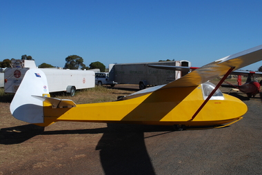
Machine - Glider - Sailplane, 1937
The Golden Eagle is an original design by Geoff Richardson. Geoff commenced gliding in the early days of the sport circa 1933 in Melbourne, flying at Coode Island and Mt Frazer. In 1934, he began construction of a secondary type glider but scrapped it upon realizing that a better design was needed. He conducted further research and came up with a sailplane of similar size and general arrangement to the Grunau Baby but with a “Gull” wing using a Gottingen 535 wing section (the same as for the Grunau Baby). Geoff did all the technical calculations himself and even made up and tested a Casein glue for the construction. Geoff competed construction of his new sailplane (which he called the “Golden Eagle”) in 1937 and it was test flown at Laverton at the western edge of Melbourne in September 1937. On the same day, at Laverton, the Gliding Club of Victoria flew its new Grunau Baby 2 sailplane which it had imported as a finished machine from Edmund Schneider in Germany. The Golden Eagle was found to fly well, having a similar performance to the Grunau Baby. In the 1950s, the Golden Eagle was modified by rebuilding the front of the fuselage to enclose the cockpit with a Perspex canopy. A landing wheel was incorporated behind the skid. Spoilers were added to the wings and a trim tab to the elevators. The Golden Eagle has been flown with the VMFG (Victorian Motorless Flight Group) for most of its long life. When donated to the Australian Gliding Museum in 2016 by Alan Patching it was probably the oldest, continuously airworthy glider in the world. Having regard to the historical significance of the Golden Eagle, the Museum has decided to not to fly it anymore to avoid risk of loss or damage. The exhibit is of great significance for Australian gliding history – the Golden Eagle is a flyable 1930s aircraft in excellent condition that was designed and built by an Australian gliding pioneer. Single seat wood and fabric sailplane finished with white wings, tailplane and rudder and yellow fuselage Registration letters “FC” on fuselage nose port side, Australian flag, Vintage Gliders Australia and VMFG decals on rudder, “Golden Eagle” lettering in red on each side of the fuselage below the canopy, Aboriginal flag decal on port side of fuselage below the canopy. australian gliding, glider, sailplane, golden eagle, richardson, patching, vmfg, victorian motorless flight group -
 Puffing Billy Railway
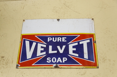
Sign - Advertising - Pure Velvet Soap - Enamel Sign, pre 1950s
Velvet Soap was a widely used laundry bar soap launched in 1906, produced by J. Kitchen & Sons, owned by John Ambrose Kitchen (1835 - 1922). Kitchen was born in Britain and emigrated to Victoria in 1854. After a less than successful period at the Caledonian and Blackwood diggings, Kitchen returned to Melbourne and joined his father and brothers in establishing a tallow candle making works. Through merger and expansion the company became the pre-eminent manufacturer of soap and candles in the eastern colonies in the mid to late 19th century. Kitchen also speculated in a number of enterprises but suffered financial setbacks as a result of the 1890s bank crashes. Despite this, the company continued to grow in the early twentieth century with the introduction of products such as Velvet Soap and Solvol. The company merged with the British company Lever Bros in 1914 who eventually took full control of the company in 1924, becoming Lever and Kitchen. Advertising for Velvet Soap in Australia was extensive and pervasive. All manner of surfaces were used to advertise the product such as building walls, roofs, and most commonly, enamelled sheet metal signs which were fastened to any available surface internally and externally. The most common form of sign that Velvet Soap used was the words 'PURE VELVET SOAP' in white lettering within a vivid dark blue, elongated Maltese cross. On the enamelled metal signs the Maltese cross sat on a red background with a yellow border. While this was the dominant form for Velvet Soap signs, there were variations from the standard. The Velvet Soap sign is of historical significance as a representative of painted signs that were once a common form of advertising during the nineteenth and early twentieth centuries. - : http://vhd.heritagecouncil.vic.gov.au/places/14447#sthash.Vb6KAUWl.dpufHistoric - Advertising Sign - Velvet SoapTin sign with white, yellow, red and blue enamel. Pure velvet soap.puffing billy, enamel sign, pure velvet soap -
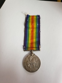 Clayton RSL Sub Branch
Medal, cc 1920's
Instituted by King George V in 1919 to mark the end of World War I and record the service given. The British War Medal 1914-20 was awarded as follows: Navy: 28 days mobilised service in Australia, at sea or overseas during prescribed periods. Army: Entered theatres of war during specified periods or left places of residence and rendered approved service overseas. Mercantile Marine: Awarded to the men and women of the Mercantile Marine who served at least six months at sea between 4th August 1914 and 11th November 1918. Licensed Pilots, Fishermen and crews of Pilotage and Lighthouse Authorities' Vessels, and of Post Office Cable Ships were also eligible. Those eligible also included members of women's organisations; persons on the staffs of military hospitals and members of recognised organisations who handled sick and wounded; and members of other duly recognised or other authorised organisations as specified in medal regulations. The qualification period of service between 5 August 1914 and 11 November 1918 was later extended to cover post-war mine clearance and service in Russia during 1919 and 1920. The ribbon has a wide central watered stripe of orange, flanked by two narrow white stripes, which are in turn flanked by two black pin-stripes, further flanked by two outer stripes of blue. The colours have no particular significance. The medal is cupro-nickel with the effigy of George V on the obverse. The reverse has an image of St George on horseback trampling underfoot the eagle shield of the Central Powers, and a skull and cross-bones, the emblems of death. Above this is the risen sun of victory. The years 1914 and 1918 are contained on the outside edge medal.GEORGIVS V BRITT OMN:REX ET IND:IMP: 2186 FRASER, Thomasbritish war medal, medal, first world war, world war one, ww1 -
 Kew Historical Society Inc
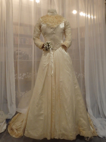
Clothing - Two Piece White Satin & Lace Wedding Dress, Mme Pamely, c.1900
This wedding dress was made for an unknown customer by a late 19th and early 20th century Richmond dressmaker known by her married name as Mrs Pamely. The dressmaker’s name is identified on Petersham ribbon on the bodice. (1877 was the first known use of a dressmaker’s name on a dress in Australia). The dress entered the Collection by donation. The donor, Netta Fuller, and her husband Alec, were long-term residents of Kew. In 1985, Netta Fuller and Elizabeth Pace launched a parade of garments sponsored by Kew Historical Society at Holy Trinity Church, Kew. The parade was called 'Downunder Dressmakers' and included a collection of over fifty items of clothing dating from 1800 to 1984. The core of the parade consisted of a collection of 19th Costumes worn by the ancestors of a Miss Gertrude Murray, a resident of Blackburn. In sourcing items for her collections, Netta Fuller collected costumes stored in old trunks and wardrobes, or even purchased from opportunity shops. Not satisfied with purchasing authentic costumes of the period, she also used these as models for artistic recreations. Following her retirement from both collecting and exhibiting, Netta Fuller donated a number of 19th Century items of clothing to the Kew Historical Society. Some garments were parts of costumes such as bodices, while others were complete outfits. Many of the latter exhibit signs of old damage, however very few of the costumes have been modified to enable them to be worn in exhibitions. Known provenance is limited to donor information, although some of these donations may have originally formed part of the collection owned by the Murray family. While the costumes are old and therefore historic, provenance is less important than the representativeness and or rarity of the costumes. Similarly, the costumes need to be evaluated as a group and separately, considering their aesthetic and artistic significance. This is the only 19th century costume in the Collection where the maker's name and address is known. To date, no other costumes by this dressmaker have been identified. The maker's business activity (1888-1905) allow one to, with an assessment of style, be relatively certain about its late Victorian construction. This adds to the item's significance even though its condition has been compromised by later removals and additions of decorative fabric on the bodice.Cream satin wedding dress comprised of a fitted bodice and a full skirt with a long wide train. Both the skirt and the bodice feature extensive use of ruched silk. Originally the bodice was covered with silk net embroidered with small white flowers. While sections of the net remain on the rear of the bodice (and on the sleeves), that on the front has been removed, probably due to damage. The name of the dressmaker is stamped on Petersham ribbon on the bodice."Madame Pamely, Costumiere, 41 Stanley St. Richmond"wedding dresses, australian fashion - 19th century, women's clothing, dressmakers - richmond (vic), netta fuller, fashion manufacturers - mrs pamely -
 Kew Historical Society Inc
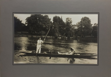
Photograph - John Duncan Brownlee and friends, Yarra River, The Artorium, 1920s
This mounted and framed photograph of a group of friends punting on the River Yarra has a number of historic and artistic associations. The photograph is primarily important as an informal photograph of the Australian baritone John Donald Mackenzie Brownlee (1900-1969), whose international career at the world's major opera houses from 1927 until his retirement in 1958 included singing at Melba's Covent Garden farewell in 1926, to recordings in the 1930s of a major series of Mozart operas in Glyndebourne Festival productions, conducted by Fritz Busch. Brownlee, born in Geelong, won the gold medal as champion vocalist at the South Street competitions in Ballarat in 1921. Moving to Paris in 1923 he began study with the French baritone, Dinh Gilly, making his operatic debut at the Trianon Lyrique in Montmartre in 1926. The most significant periods of his operatic career were with the Paris Opera from 1927 to 1936, and at the Metropolitan Opera from 1937 to 1957. After his move to Paris in 1923, he is recorded as revisiting Australia in 1928 as a member of the Melba-Williamson Company, and 24 years later in 1952. The photograph of Brownlee and the Gardners in a punt on the Yarra, while putatively dated to 1925, must be from earlier in the 1920s before his move to Paris, or later during the Melba-Williamson Company season. Before his move to Paris in 1923, Brownlee had lived in Belmont Avenue, Kew, where he must have developed a friendship with the Gardners. The photograph has additional artistic significance as it was produced at 'The Artorium', James Beament's design studio next to the Hawthorn Town Hall at 362 Burwood Road. With a home at 33 Uvadale Road (designed by Eric Nicholls, who managed the architectural practice of Walter Burley and Marion Mahony Grifffin from 1924 to 1932), Beament painted a number of significant murals for the Griffin practice, including those at the Capitol Theatre in Melbourne.A photograph of recreational activities on the River Yarra. The photograph is historically significant as a professionally produced photograph of the Australian operatic baritone John Brownlee, either before his move to Paris in 1923, or in 1928 during the Melba-Williamson Company operatic tour of Australia. The photograph has additional aesthetic significance as it was produced in James Beament's Hawthorn Studio - The Artorium - at 362 Burwood Road, next to the Hawthorn Town Hall.Framed photograph of John Duncan Brownlee, the Australian tenor, with Enid Gardner and friend in a punt on the Yarra River. Brownlee was born in Geelong but before his move to Paris in 1923, he lived for a period in Belmont Avenue, Kew. Three labels on reverse. 1. "John Duncan Brownlee, Operatic Star, originally of Geelong later resident of Kew at Belmont Av, on the pole. Also in the punt - Edith Gardner a friend. The Gardners lived on the east corner of Edgevale Rd. & Cotham. Approx. 1925." 2. "This picture is the property of Kew Historical Society 1/4/79". 3. Tel. Hawthorn 842 THE ARTORIUM ...."john brownlee (tenor), punting, recreation - yarra river (kew), james beament, the artorium -- 362 burwood road -- hawthorn (vic.) -
 Melton City Libraries
Photograph, Melton Railway Bridge, c.1884
"The Melton Viaduct, opened in 1886, is of State heritage significance as a very large and visually distinctive wrought iron, lattice girder trestle bridge over the Werribee River (now Melton Reservoir). It comprises 18.3 and 9.1 metre spans, in a generally alternate arrangement, of total length 375 metres, and standing 38 metres over the Werribee River. Wrought iron small section iron was used to build tension trussed trestle legs, which supported four lines of rivetted wrought-iron deck-type double lattice trusses. It has bluestone abutments and pier bases of coursed rock-faced bluestone with drafted margins. The larger half-piers, now usually submerged in the Melton Reservoir have sharp tapered cutwaters and curved coping at the tops. While designed to carry two rail tracks it has only ever been used as a single track line. Despite several alterations to its deck structure, it remains an outstanding example of a lighter structural design employing open metal trestle supports and metal truss girders. The direct Melbourne to Ballarat railway link of which the Melton viaduct was the major engineering work contributed significantly to the history and development of Victoria. This new link reflected Ballarat’s diversifying economy as well as the commercial and political influence of the metropolis. Construction of the bridge, and the associated large workers camp, were extensively photographed, documenting an important episode in local history. The railway enabled the development of new industries in the Melton area, notably the timber industry and a chaff industry of national importance, greatly facilitated the later transition of the Shire from a pastoral to a farming economy, and struck a major blow to Melton township’s era as a wayside town servicing Ballarat road (especially coach) traffic". Melton Railway Bridge being built across the Werribee Rivertransport -
 Eltham District Historical Society Inc
Photograph - Digital Photograph, Alan King, St Matthew's Church and Hall, Panton Hill, 27 March 2008
St. Matthew's Church has historic significance as the town's church and physical and social focus for the community. The standard design buildings are good examples and important streetscape elements. The war memorial cross is the area's monument to the 20th century wars and its modest scale in comparison with the granite Eltham and towered Kangaroo Ground memorials illustrates the lack of affluence in the town and surrounding area. The grouping of church, school, store and post office is typical of country villages throughout Victoria. The Radiata Pine plantings are significant as an intact line of shelterbelt planting typical of the early 20th century. (Bick Study 1992) Covered under Heritage Overlay, Nillumbik Planning Scheme. Published: Nillumbik Now and Then / Marguerite Marshall 2008; photographs Alan King with Marguerite Marshall.; p63 Panton Hill’s first church services were held in a simple building made of paling timber, opposite the Hotel de France. The building was also used for Sunday School, a school and a hall.1 The St Matthew’s Church and hall at the corner of Church Road and Kangaroo Ground-St Andrews Road, were built in the early 20th century in the standard rectangular style of the times. The intact belt of Radiata Pines was common at that time. The war memorial concrete cross is the area’s monument for the 20th century wars. It is much more modest than those in Eltham, and particularly in Kangaroo Ground, demonstrating those townships’ comparative affluence.2 Early settler J Hughes, who donated the land to the Church of England, was the first to be married at St Matthews when he married Rachel Coutie. In later life he became a minister of religion.3 One much-liked preacher was George Hollow, who with his sister playing the harmonium, conducted church services at Panton Hill, St Andrews and Christmas Hills, for many years.This collection of almost 130 photos about places and people within the Shire of Nillumbik, an urban and rural municipality in Melbourne's north, contributes to an understanding of the history of the Shire. Published in 2008 immediately prior to the Black Saturday bushfires of February 7, 2009, it documents sites that were impacted, and in some cases destroyed by the fires. It includes photographs taken especially for the publication, creating a unique time capsule representing the Shire in the early 21st century. It remains the most recent comprehenesive publication devoted to the Shire's history connecting local residents to the past. nillumbik now and then (marshall-king) collection, panton hill, st matthew's church, panton hill war memorial -
 Bendigo Historical Society Inc.
Document - SPECIMEN COTTAGE COLLECTION: VARIOUS DOCUMENTS
Various documents in plastic folders. Topics are: 1. Rocky Vale Villa in Maiden Gully built by William Beebe Snr, historical information and significance assessment. 2. The powder magazines of Bendigo and Eaglehawk talk given by Ralph Birrell. 3. Ralph Birrell obituary. 4. Early Surveyors on the Bendigo goldfields 1852-1860 three pages essay by Ralph Birrell. 5. History of Eaglehawk courthouse and log lock up with four photographs. 6. Submission from the National Trust regarding Bendigo Pottery. 7. Fistcuffs, Diamonds and Lace synopsis of a novel by Ann Rayner on the boxer Abednego Thompson after whom the name of the City of Bendigo is said (by same to be derived. 8. Historical facts and dates on Bendigo by the Royal historical society of Victoria, Bendigo branch. 9. Arcades of Bendigo, by Tom Luke. 10. Benedict Branch family history with picture. Benedict invented a Miners Safety cage in 1883 and was awarded a medal, photos of the cage and medal included. 11. Burke & Wills 150 years on pamphlet, Jim Evans newspaper article, notes and photos of the monument at the Bendigo cemetery. 12. Marlborough House document on the history of this house. 13. Codicil to the last will and testament of William Beebe of Inglewood Road, Sandhurst. 18th September 1891. 14. Document outlining the life of Sister Jessie Aitken 15. Document - W. Anderson and Sons business in Mitchell Street 'Fancy goods'' history of the family. 16. Handwritten notes on Florence Anderson. 17. Document family history of Hamlet Smart Appleby. 18. Document - Amy Castles ''The little Bendigonian singer'' 19. Quentin Clifford (Cliff Binks words in remembrance, Bendigo Monday 23rd November 2015. 20. Background report on Vahland drinking fountain, list of William Vahland buildings, copies of photos of Vahland descendants and two brochures celebrating Vahland. 21. Blank invoice for the Taraxale Brewing Co. of Golden Square - G. A. Pethard, manager. -
 Eltham District Historical Society Inc
Photograph - Digital Photograph, Alan King, Former St Andrews State School No. 128 building, 23 January 2008
In 1858 the Caledonia Common School No.128 opened at Queenstown, about 1.6km upstream on Diamond Creek from the present site of the old St Andrews school. The school was renamed Queenstown Common School No. 128 in 1867. In 1882, due to declining numbers of pupils at Smiths Gully and increasing numbers in Queenstown the school was moved from a leased building, owned by Head Teacher Robert Harris, into a new larger building on the corner of School and Heidelberg-Kinglake roads which incorporated the original single room school building, which had been moved from Smiths Gully, and included a teacher’s three-roomed residence. In 1887 the school was replaced by the Queenstown State School No. 128. The school and town were renamed St Andrews in 1952. In 1983 a new school was built, 500 metres south of the old school and the old school became the St Andrews Community Centre. Of significance is the c1887 school building (including part of the c1876 Smith's Gully school moved to the site and incorporated into the c1887 school building), the c1911 new room, the c1929 cloakroom, the c1930 renovations, the c1956 new infant room; the c1961 office and storeroom, as well as the c1950 Himalayan Cedar tree and the entire site to the title boundaries. The school building is historically significant for its links with the early settlement of the area and because its use of materials from the former Smith's Gully State school illustrates the common 19th and early 20th century practice of relocating State school buildings based on need. The school building is historically and socially significant because it served the local community, as a school, from 1887 to the late 1970s/early 1980s and because since then it has been used for other community purposes. Covered under Heritage Overlay, Nillumbik Planning Scheme. Published: Nillumbik Now and Then / Marguerite Marshall 2008; photographs Alan King with Marguerite Marshall.; p69This collection of almost 130 photos about places and people within the Shire of Nillumbik, an urban and rural municipality in Melbourne's north, contributes to an understanding of the history of the Shire. Published in 2008 immediately prior to the Black Saturday bushfires of February 7, 2009, it documents sites that were impacted, and in some cases destroyed by the fires. It includes photographs taken especially for the publication, creating a unique time capsule representing the Shire in the early 21st century. It remains the most recent comprehenesive publication devoted to the Shire's history connecting local residents to the past. nillumbik now and then (marshall-king) collection, st andrews, queenstown state school no. 128, smiths gully state school -
 Eltham District Historical Society Inc
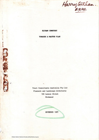
Document - Report, Tract Consultants Australia Pty Ltd, Eltham Cemetery: Towards a Master Plan, Nov 1987
BACKGROUND The Eltham Cemetery is of historic significance to the Eltham area. The Trust was established in 1858 and has administered and maintained the cemetery from that date right up to the present. Among the more noteworthy graves is that of Sir William Irvine, a former State Premier and Chief Justice of Victoria. Eltham Cemetery is surrounded on three sides by urban development. Montsalvat Artists Colony adjoins the remaining (eastern) side. A Joint Select Committee of Parliament called the “Mortuary Industry and Cemeteries Administration Committee" (MICA) enquired into the land requirements at the Eltham Cemetery in 1986. The MICA recommendations contained in its 1986 report are included in the Appendices attached to this report. Although the recommendations have not been adopted by the Government it is interesting to note that the MICA report recommended the use of the bulk of the land for cemetery purpose. In June of 1987, the Cemetery Trust was expanded to include additional members from the Eltham Community by the Minister for Health. At the same time, he instructed the Trust to resolve the land requirement issues. As a result of this Ministerial direction, Tract Consultants has been instructed by the Eltham Cemetery Trust to prepare a report addressing the issues raised in the Minister's letter (see Appendix 1) to the Trust. Principally, the study will examine options available for development of the Cemetery. These options will explore possible boundaries, cemetery design, vegetation, the overall environment, landscaping and financial planning for the Cemetery operations. Appendix 2 details the Cemetery Trusts Terms of Reference for the Study. Before commencing the study in detail, additional basic information was sought; viz: a) sub-soil and rock analysis; and b) feature survey by a Licensed Surveyor. The results from both exercises are included as appendices to this report. Section three includes a summary of the findings along with other analytical results. Also: Eltham Cemetery - planning bewteen 1859 to 1860; research by Alan Sheehan April 2015, collated by Harry Gilham, EDHS, April 2016 (2 pages) PROV Guide 5: Cemetery Records (8 pages), printed 7 May 2014Development of Eltham Cemeteryeltham cemetery trust, master plan, mica, montsalvat, mortuary industry and cemeteries administration committee, tract consultants -
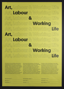 Mission to Seafarers Victoria
Poster, Art, Labour and Working Life, 2018
A poster printed by the RMIT in 2018, to promote an exhibition of works at the MTSV about the interelationships between labour, working life and artistic practice. BACKGROUND The Work of Art was an exhibition about labour, working life and artistic practice. The exhibition explored three aspects of art's relationship to work: (1) artworks about contemporary labour, (2) the labour of art-making itself and (3) the often precarious aspects of life as a working artist. Throughout the exhibition, different artists "worked" from the space of the gallery, revealing the layers of manual, emotional and intellectual labour involved in the work of art. CONTRIBUTION I was invited to develop the exhibition by the "Murphy Group", a group of researchers at RMIT. As the lead co-curator for the exhibition, I researched the history of artistic responses to working conditions. Through this process I identified a gap - while many artists have explored the conditions of labour and working life in their artworks, fewer have drawn attention to the working conditions of artists themselves. This became a key theme in the exhibition. The exhibition presented the work of nine contemporary Australian artists, including high profile and mid-career artists like Bindi Cole and Bek Conroy, alongside the work of emerging artists. In addition to the display of artworks throughout the space, five artists worked performatively, bringing to life the processes and manual labour involved in artmaking. A public forum extended the complex discussion on the relationship between art, work and labour. SIGNIFICANCE The works were presented in the context of a public space that has a strong relationship to contemporary labour - the Mission to Seafarers in Docklands. The Mission to Seafarers is a working mission that provides support to ship-workers. Presenting the works in this space created a real connection between the artworks and the lived experience of precarious labour. The exhibition reached a large audience including over 1000+ visitors in 10 days. It fostered a high engagement on social media and attracted media coverage including a feature in ArtsHub.A record of the ongoing involvement of the MTSV in art, and working with the art community by providing a suitable venue and display space.A3 size yellow paper promotional poster, double-sided. Three-quarters of the front of the poster is covered with the repeated line "Art, Labour & Working Life" in large font, to form ten rows. These rows are in outline form except for picked out words which are in entirely black characters and these cascade down, a row at a time, a word at a time, to form the same line ("Art, Labour & Working Life"). rmit, 2018, events, labour, working life, artistic practice, hiring event, cultural events, multimedia, nicholas walton-healey -
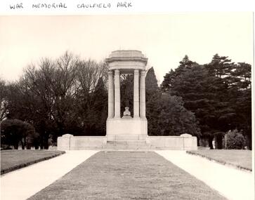 Glen Eira Historical Society
Article - Memorials in Glen Eira
This file contains 11 items relating to War Memorials in Glen Eira: 1/Black and white photograph, undated, source unknown, of Caulfield Park War Memorial 2/Copy of photograph of Caulfield Park War Memorial, undated, source unknown 3/Colour photograph of Caulfield Park War Memorial, dated June 1982, source unknown, and slide of same 4/Print of webpage of Friends of Caulfield Park, dated 02/08/2013 with colour image of and information about the war memorial there 5/Two black and white photographs, undated and source unknown, of war memorial at Koornang Park 6/Four colour photographs and one black and white copy of photograph of war memorial and its inscription at Koornang Park. Date and source unknown 7/Article dated 30/04/2013 from GLENEIRA LEADER about funding for plaque for Lone Pine at Caulfield Park 8/Article dated 23/04/2013 from THE AGE about state funding for repair of war memorials including one at McKinnon 9/Article dated June 2013 from GLEN EIRA NEWS about state funding for repair of five WWI memorials in Glen Eira. Includes two photographs. 10/Article from GLEN EIRA NEWS dated April 2012 about restoration of Caulfield Park War Memorial. Includes colour photography 11/A booklet titled 'The Burra Charter and its Application: Essay 3: War Memorial, Caulfield Park', written in October 2000 by Eleanor Bishop. The booklet contains a conservation analysis, statement of cultural significance, statement of conservation policy, and conservation management plan for the Caulfield Park War Memorial. This includes a brief history and description of the Caulfield Park War Memorial, and 7 colour photographs of the memorial dated September 2000, 2 undated black-and-white photographs, and a copy of the original drawing of the memorial which won its design contest in 1930.monuments and memorials, war memorials, plaques, world war 1914-1918, caulfield park, friends of caulfield park, ritchie mr, world war 1939-1945, koornang park, city of caulfield, glen eira, glen eira council, mckinnon war memorial, hopetoun gardens, hyams jamie, mckinnon, lobo oscar, esakoff margaret, hyams jamie, delahunty ms, caulfield rsl, kiernan noel, bishop eleanor, caulfield park war memorial, foot henry b., parks and reserves, paddy's swamp, caulfield, royal victorian institute of architects, caulfield municipal council, architectural competitions, schefferle n. mr, architectural features, conservation management plan -
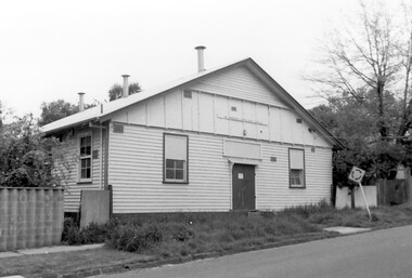 Surrey Hills Historical Society Collection
Photograph, Scout Hall at 7 Robinson Road, Surrey Hills in 1990
The Box Hill Reporter noted on 22 January 1926 that at the monthly meeting of the Surrey Hills Progress Association the Secretary reported that “the ground had been purchased for the Boy Scout Hall, that plans had been prepared, and accepted by the building committee. As soon as the timber was available the work would be proceeded with. The Boy Scout Hall movement has been taken up by the association to try to secure a permanent meeting place for the boys of the district. Up till now they have no fixed place, nor have they had a qualified scout master. Mr. Bert Chenu, one of the committee, has been appointed to that position, and is carrying out his duties energetically. Having raised enough money to purchase the land (situated in Robinson's road, Surrey-Hills near the Drill Hall) the association's committee is now about to erect the building by means of properly organised working bees.” The Association organised markets, card evenings and dances to raise necessary funds. The volunteer labour included the parents of boys who had become scouts, led by builder Robert Hayes of 186 Union Road and his son, who was also a builder. Early ownership is unclear as it is believed that it was not purchased by the scouting movement until 1955. The hall was used by other groups as well as the scouts. Benmont Kindergarten operated on the site from c1930. This is confirmed by oral testimony, Sands & McDougall entries and the Alan Hold property register (part of the SHNC Heritage Collection.) It was also used as a ballet school and for local dances. The hall was situated on a small block of land, just 410 sq m, and in late 2019 it was put up for sale by Scouts Victoria. Most recently home to 1st Boroondara Scout Group and previously 11th Camberwell Scouts, it was sold for something near $1.3M. During May 2020 the modest hall was demolished. Items of significance were removed before the sale by Scout Heritage. A black and white photograph of a building with a small sign identifying it as 11th Camberwell Central Scout Group.robinson road, surrey hills, scout halls, scouts, buildings, structures and establishments, (mr) robert hayes, union road, builders, surrey hills progress association, benmont kindergarten, dances, ballet schools -
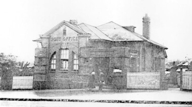 Surrey Hills Historical Society Collection
Photograph, Surrey Hills Post Office
The post office opened at this location in 1912. It was demolished in 2000. Post office history in the area: Until 1883 when the railway came through to Surrey Hills, this was essentially a rural community of scattered farms. Land subdivisions soon occurred along the railway line and limited postal services followed soon after, although a ‘permanent’ home for the post office was two decades away. George Sim Junior is acknowledged as our first postmaster; he opened a post office on 1 October 1884 in his father’s general store at 619-621 Canterbury Road, a few doors down from the Surrey Hills Hotel on the corner of Union Road. Over the next 20 years, the Surrey Hills Post Office moved several times into temporary, shared accommodation – in 1889 into Woodhead’s Corner Store at 364 Canterbury Road; then in 1895 to No 376, Hansen’s Exchange Building, part of Hansen’s Terrace (demolished) and in 1901 to 109 Union Road, on the corner of Windsor Crescent. Following Federation in 1901, the new Commonwealth Government established the Postmaster-General's Department to provide postal services to the nation. Many of the post offices constructed in the following years reflected a growing sense of Australian pride and nationalism. It was 1914 when building commenced on the ‘purpose-built’ post office at 609 Canterbury Road, Surrey Hills. Described as “a polychromatic Federation Freestyle building”, it served as the local post office for nearly 85 years until sold by the Commonwealth Government in c1999, after which the post office moved to the current, less prominent site at 100 Union Road. For nearly 10 years under private ownership, the building was successfully adapted for use as the base for two businesses, Gargoyles and Dragons and later the Surrey Sculpture Studio, and fortuitously the historic integrity of the building was maintained. However although renovated in the 1990's, structurally sound and of historic significance, it was not protected under local or commonwealth heritage legislation and was demolished soon after sale. This is an early image of a demolished building which should have been protected. In 1991, when the City of Camberwell conducted a heritage study, (which still informs the basis of the City of Boroondara’s heritage guidelines for this part of the municipality,) the post office was owned by the Commonwealth Government. As such, it could not be considered for heritage listing by the local authorities. Some years later, the Commonwealth and Australia Post rather belatedly recognized not only that post offices have heritage and social value, but also that the architecture of post offices as community buildings is important. A heritage management scheme was developed for the buildings they own or control under the Environment Protection and Biodiversity Act 1999. Unfortunately, the Surrey Hills Post Office had been sold and demolished before this was finally enacted in 2004. Black and white image, perhaps from a post card, of Surrey Hills post office at 609 Canterbury Road. The building is flanked by a picket fence. There is a woman, a dog and a man in front of the entrance. The man is in uniform - possibly a postal employee.post offices, canterbury road, businesses, surrey hills post office, surrey sculture studio, gargoyles and dragons -
Federation University Historical Collection
Document - Reports, Martin Westbrooke, Nanya Station
Nanya Station, owned and managed by the University of Ballarat (now Federation University Australia), was purchased with assistance from the Department of Environment and Heritage Government Caring for our Country program. Nanya Station is located in the Scotia country, west of the Darling Ana-Branch in far western New South Wales and consists of the Nanya Western Lands Pastoral Lease 3281 – Perpetual Leasehold Lot 1244 in Deposited Plan 762778, Parish of Winnebaga, County of Tara and part of Lot 1242 County of Windeyer. Nanya is within the tribal area of the Danggali Aboriginal people, a sub-group of the Barkindji. Many Aboriginal sites have been recorded adjacent to major rivers in the region providing evidence that these areas supported a large population. The Scotia region has one of the shortest stock grazing histories of western NSW. Along with five other Scotia properties, Nanya was created as a pastoral lease in 1927. The first European settlement on the land followed exploration of the area by Sturt and Eyre. In 1854, the Lake Victoria lease which encompassed this area comprised 465,000ha.included Scotia blocks 1, 2, 3 and 4, Amoskeag and Winnebaga which formed the area known as the Scotia. It was described as a region of thick mallee scrub, interspersed with bluebush flats and Belah woodland. In the 1920s artesian water was found and the dry Scotia country was surveyed and divided into six Homestead leases allocated by ballot (Withers 1989). All properties were approximately 30,000ha, with a recommended stocking level of 3,000 sheep. Winnebaga (renamed Nanya) was taken up by Gordon Cumming. He initially dug a dam near the southeast corner of the property. A larger ground tank and rudimentary dwelling at the site of the present complex was later established. An adjacent area was cleared and cropped to provide feed for the horses used in digging the earth tanks. The ruins of the original building are located between the shearing shed and Homestead Tank. A cottage was built in the 1930s and a more substantial Red Gum framed homestead in the early 1950s. The lease was held by Mr Gordon Cumming until 1984 when it was purchased by Mr Norm Scadding as an extension to the adjacent lease, Belvedere. It was sold in 1995 to Mr Rob Taylor of Waikerie then in 1999 to BeMax Pty. Ltd., a sand mining company. These last three owners all permitted use of the property by the University for teaching and research. The Centre for Environmental Management at the University of Ballarat had been involved in studies of flora and fauna in western New South Wales since 1988. Studies became concentrated on the Scotia region with its variety of intact ecosystems due to a short pastoral history. Of particular significance is a system of natural salt lakes of which the most extensive is the Scotia Discharge Complex located on Nanya Station. An extensive vegetation survey of the Scotia region Westbrooke et al. 1998) highlighted the significance of the area both in terms of the range of communities in relatively intact condition and the occurrence of species and communities of restricted distribution. Nearly 400 species were recorded of which nine had either not previously been recorded or have restricted distribution in western NSW. Twenty-two plant communities occur on Nanya Station of which two, Halosarcia lylei low open shrubland and Hemichroa diandra/Halosarcia/Frankenia low open shrubland, are dominated by species not previously recorded from NSW. H. lylei and Acacia loderi shrublands are listed as endangered under the NSW Threatened Species Conservation Act. As noted, the area has a relatively short grazing history and, due to the presence of large areas of mallee with a Triodia understorey and restricted water supplies, stocking rates have been low. The diversity of ecosystems in relatively intact condition and extensive areas of old growth mallee made Nanya a highly significant refuge for biological diversity. This factors led to the purchase of Nanya Station by the University of Ballarat in 2004 with the assistance of the Department of Environment and Heritage for the purposes of conservation, research and education. In 2010 the southern paddocks of Nagaella Station (10,000ha.) which lie along the northern boundary, were purchased with the assistance of Lower Murray Darling Catchment Management Authority and added to the Nanya lease to provide complete protection for the communities of the Nanya Discharge Complex and further high quality Malleefowl habitat. Four digital reports documents relating to Federation University's Nanya Station, Western New South Walesnanya station, scotia country, pastoral lease, winnebaga county, darling ana-branch, martin westbrooke, environmental education, nagaella station, lower murray darling catchment management authority, conservation research education, ian gribble, pat prevett, ian henderson, danggali -
 The Beechworth Burke Museum
Photograph - Lantern Slide, c1900
This glass slide presents an image of the Old Beechworth Post Office and was taken in the year 1900. The building displayed within the image is not that of the post office in its original form; the post office originally consisted of only a simple wooden building. With the establishment and growth of new towns across Victoria, as well as an increased need for more consistent communications with the City of Melbourne, this modest building was soon deemed inadequate. In 1858 it was brought into the style of the changing times, with the tall clock tower added in 1865. This transition aligned with a pattern of refurbishment and conversion of many Beechworth buildings (which could be seen during the 1860s-70s), aiding in the growth and prosperity of the town. Early makeshift homes were turned into more substantial dwellings, featuring elements such as weatherboard, brick, and granites materials, and gabled or hipped roofs with iron lacework fringing the verandah. These refurbishments were temporarily halted in March of 1867 when a fire swept through the town, damaging many buildings including the post office. This led to further reconstructions on the building, including heightening of the clock tower, and in 1870 the two-storey Italianate style building was completed. The Old Beechworth Post Office itself also holds significance due to its connection with one of Australia's most infamous families. It reportedly played an important role in communicating the news of the 1880 murders of police at Stringybark Creek by the Kelly Gang. Lantern slides, sometimes called 'magic lantern' slides, are glass plates on which an image has been secured for the purpose of projection. Glass slides were etched or hand-painted for this purpose from the Eighteenth Century but the process became more popular and accessible to the public with the development of photographic-emulsion slides used with a 'Magic Lantern' device in the mid-Nineteenth Century. Photographic lantern slides comprise a double-negative emulsion layer (forming a positive image) between thin glass plates that are bound together. A number of processes existed to form and bind the emulsion layer to the base plate, including the albumen, wet plate collodion, gelatine dry plate and woodburytype techniques. Lantern slides and magic lantern technologies are seen as foundational precursors to the development of modern photography and film-making techniques. This glass slide captures social and historical significance as it displays the Old Beechworth Post Office in 1900, a building that demonstrates the prosperity and growth of Beechworth as a town during this time period. This slide also holds a level of aesthetic significance due to the Italianate style building that is featured in its image; a style that became very popular during the nineteenth-century. Thin translucent sheet of glass with a square image printed on the front and framed in a black backing. It is held together by metal strips to secure the edges of the slide.Obverse: x / burke museum, beechworth, lantern slide, slide, glass slide, plate, burke museum collection, photograph, monochrome, beechworth post office, beechworth post office kelly gang, 1900, 1900 beechworth, growth of beechworth, 1867 beechworth fire, old beechworth post office, beechworth post office reconstructions, italianate style, italianate style buildings, italianate style beechworth post office -
 Eltham District Historical Society Inc
Photograph - Digital Photograph, Jim Connor, Edendale Farm Homestead, 11 December 2014
Edendale Farm is Nillumbik Shire Council's environment centre situated in Gastons Road, Eltham between the railway and the Diamond Creek. The homestead on the property was built in 1896 and is of historical significance, being the subject of a Heritage Overlay under the Nillumbik Planning Scheme. The Edendale property was originally part of an extensive land purchase in 1852 from the Crown by pioneer Eltham farmer Henry Stooke. He initially purchased 51 acres and later expanded his holdings by purchasing another three adjacent Crown allotments extending northerly from Josiah Holloway's Little Eltham subdivision. Despite clearing the land, Stooke did not build on this property, choosing to live on his property "Rosehill" at Lower Plenty. In 1896 Thomas Cool, Club Manager of the Victoria Coffee Palace in Melbourne purchased 7 acres of the original Stooke land and built the house now known as Edendale. Cool did not farm the land, instead using it as a gentleman’s residence, retiring to Eltham at weekends. In 1918 he purchased an additional 7 acres but in 1919 he sold the property. Later owners included J.W. Cox, the Gaston family and D. Mummery. In the 1980s the Eltham Shire Council purchased the site for use as a Council depot, but this use did not proceed. Subsequently, it was used as the Council pound. The Edendale Farm Pet Education and Retention Centre was established in the summer of 1988/1989 and was set up to replace the existing dog kennels with a high standard pet retention centre. The design style of the building was established to compliment the features of the existing house. It was equipped with 10 retention pens, a veterinary room and a pet education area where school children and other interested parties learnt about pet care procedures. It was later developed into a community farm and was run by an advisory committee and in 2000 it became an Environment Centre. In early 2006 an advisory committee was established for the development of a master plan for future development at Edendale Farm. The committee included Russell Yeoman, a former long-time shire planner and founding member of the Eltham District Historical Society. At the time of filming the Master Plan and future for Edendale was about continuing to develop Edendale as a centre of environment learning and looking at expanding displays and school program, running a lot more of life-long learning and workshops around sustainable living.jim connor collection, edendale community farm, edendale farm, eltham, gastons road -
 Eltham District Historical Society Inc
Opening of Meruka Childcare Co-operative, Meruka Park, 5 Meruka Dr, Eltham, April 1994
In 1919 J.B. North, a violinist with the then Melbourne Symphonic Orchestra, and Monsieur Leon Lambert, a French architect, who later designed the Glaciarium Ice Skating Rink, purchased three available farms, Looker's, Wright's and Taylor's, approximately 60 acres, the area running along the creek and being bordered by the present day Ryans Road, Karingal Drive and Sherbourne Road. The farms were used for orchards and market gardens. Leon Lambert designed and built two homes on the farm site, one for the North family, ‘Tralford’, and the other, ‘Glen Ellen’, for himself and his wife. The homes were considered as "brother and sister" and they each included in their design an identical bay window in the main living area. "Glen Ellen" originally comprised kitchen, lounge room, inglenook, dining room, bath room and sleepout. Although the home has been extended over the years, much of the original architecture has been retained including timber panelling and three fireplaces. The land was subdivided in approximately 1966 with "Glen Ellen" retaining approximately one half acre of land fronting Meruka Drive. The property then passed from the Charleston family to Gerald and Margaret Sutton in 1976 and again was sold in 1980 and lastly sold again in 1994. The Norths named their house 'Tralford'. According to Marjorie North, the name Meruka was suggested by Alan Gardner and so was apparently not used by the North family. The name appears to be of Indian origin and its connection with the land is not known. ‘Tralford’ stayed in the North family for many years. Eltham Council acquired the house to create Meruka Park. The house was used for some years by the Council as a community arts facility and as emergency accommodation. It fell into disrepair and was demolished about 1990. The Meruka Child Care Centre has been built on the site and incorporates some of the architectural features of the old house. The Co-op was opened in April 1994. The original drive flanked by large old cypress trees remains. These trees are considered to be of local heritage significance and for this reason Meruka Park is covered by a Heritage Overlay under the Nillumbik Planning Scheme. Part of the park has been preserved as habitat for rare local flora. LL's house, named ‘Glen Ellen’, remains in a well-preserved state and fronts Meruka Drive.cr pam sladden, eltham, meruka child care co-operative, meruka house, meruka park -
 Eltham District Historical Society Inc
Opening of Meruka Childcare Co-operative, Meruka Park, 5 Meruka Dr, Eltham, April 1994
In 1919 J.B. North, a violinist with the then Melbourne Symphonic Orchestra, and Monsieur Leon Lambert, a French architect, who later designed the Glaciarium Ice Skating Rink, purchased three available farms, Looker's, Wright's and Taylor's, approximately 60 acres, the area running along the creek and being bordered by the present day Ryans Road, Karingal Drive and Sherbourne Road. The farms were used for orchards and market gardens. Leon Lambert designed and built two homes on the farm site, one for the North family, ‘Tralford’, and the other, ‘Glen Ellen’, for himself and his wife. The homes were considered as "brother and sister" and they each included in their design an identical bay window in the main living area. "Glen Ellen" originally comprised kitchen, lounge room, inglenook, dining room, bath room and sleepout. Although the home has been extended over the years, much of the original architecture has been retained including timber panelling and three fireplaces. The land was subdivided in approximately 1966 with "Glen Ellen" retaining approximately one half acre of land fronting Meruka Drive. The property then passed from the Charleston family to Gerald and Margaret Sutton in 1976 and again was sold in 1980 and lastly sold again in 1994. The Norths named their house 'Tralford'. According to Marjorie North, the name Meruka was suggested by Alan Gardner and so was apparently not used by the North family. The name appears to be of Indian origin and its connection with the land is not known. ‘Tralford’ stayed in the North family for many years. Eltham Council acquired the house to create Meruka Park. The house was used for some years by the Council as a community arts facility and as emergency accommodation. It fell into disrepair and was demolished about 1990. The Meruka Child Care Centre has been built on the site and incorporates some of the architectural features of the old house. The Co-op was opened in April 1994. The original drive flanked by large old cypress trees remains. These trees are considered to be of local heritage significance and for this reason Meruka Park is covered by a Heritage Overlay under the Nillumbik Planning Scheme. Part of the park has been preserved as habitat for rare local flora. LL's house, named ‘Glen Ellen’, remains in a well-preserved state and fronts Meruka Drive.eltham, meruka child care co-operative, meruka house, meruka park, cr. peter graham, peter staples, richard allen, sheryl garbutt, bill penrose -
 Eltham District Historical Society Inc
Opening of Meruka Childcare Co-operative, Meruka Park, 5 Meruka Dr, Eltham, April 1994
In 1919 J.B. North, a violinist with the then Melbourne Symphonic Orchestra, and Monsieur Leon Lambert, a French architect, who later designed the Glaciarium Ice Skating Rink, purchased three available farms, Looker's, Wright's and Taylor's, approximately 60 acres, the area running along the creek and being bordered by the present day Ryans Road, Karingal Drive and Sherbourne Road. The farms were used for orchards and market gardens. Leon Lambert designed and built two homes on the farm site, one for the North family, ‘Tralford’, and the other, ‘Glen Ellen’, for himself and his wife. The homes were considered as "brother and sister" and they each included in their design an identical bay window in the main living area. "Glen Ellen" originally comprised kitchen, lounge room, inglenook, dining room, bath room and sleepout. Although the home has been extended over the years, much of the original architecture has been retained including timber panelling and three fireplaces. The land was subdivided in approximately 1966 with "Glen Ellen" retaining approximately one half acre of land fronting Meruka Drive. The property then passed from the Charleston family to Gerald and Margaret Sutton in 1976 and again was sold in 1980 and lastly sold again in 1994. The Norths named their house 'Tralford'. According to Marjorie North, the name Meruka was suggested by Alan Gardner and so was apparently not used by the North family. The name appears to be of Indian origin and its connection with the land is not known. ‘Tralford’ stayed in the North family for many years. Eltham Council acquired the house to create Meruka Park. The house was used for some years by the Council as a community arts facility and as emergency accommodation. It fell into disrepair and was demolished about 1990. The Meruka Child Care Centre has been built on the site and incorporates some of the architectural features of the old house. The Co-op was opened in April 1994. The original drive flanked by large old cypress trees remains. These trees are considered to be of local heritage significance and for this reason Meruka Park is covered by a Heritage Overlay under the Nillumbik Planning Scheme. Part of the park has been preserved as habitat for rare local flora. LL's house, named ‘Glen Ellen’, remains in a well-preserved state and fronts Meruka Drive.eltham, meruka child care co-operative, meruka house, meruka park, cr. john cohen -
 Eltham District Historical Society Inc
Opening of Meruka Childcare Co-operative, Meruka Park, 5 Meruka Dr, Eltham, April 1994
In 1919 J.B. North, a violinist with the then Melbourne Symphonic Orchestra, and Monsieur Leon Lambert, a French architect, who later designed the Glaciarium Ice Skating Rink, purchased three available farms, Looker's, Wright's and Taylor's, approximately 60 acres, the area running along the creek and being bordered by the present day Ryans Road, Karingal Drive and Sherbourne Road. The farms were used for orchards and market gardens. Leon Lambert designed and built two homes on the farm site, one for the North family, ‘Tralford’, and the other, ‘Glen Ellen’, for himself and his wife. The homes were considered as "brother and sister" and they each included in their design an identical bay window in the main living area. "Glen Ellen" originally comprised kitchen, lounge room, inglenook, dining room, bath room and sleepout. Although the home has been extended over the years, much of the original architecture has been retained including timber panelling and three fireplaces. The land was subdivided in approximately 1966 with "Glen Ellen" retaining approximately one half acre of land fronting Meruka Drive. The property then passed from the Charleston family to Gerald and Margaret Sutton in 1976 and again was sold in 1980 and lastly sold again in 1994. The Norths named their house 'Tralford'. According to Marjorie North, the name Meruka was suggested by Alan Gardner and so was apparently not used by the North family. The name appears to be of Indian origin and its connection with the land is not known. ‘Tralford’ stayed in the North family for many years. Eltham Council acquired the house to create Meruka Park. The house was used for some years by the Council as a community arts facility and as emergency accommodation. It fell into disrepair and was demolished about 1990. The Meruka Child Care Centre has been built on the site and incorporates some of the architectural features of the old house. The Co-op was opened in April 1994. The original drive flanked by large old cypress trees remains. These trees are considered to be of local heritage significance and for this reason Meruka Park is covered by a Heritage Overlay under the Nillumbik Planning Scheme. Part of the park has been preserved as habitat for rare local flora. LL's house, named ‘Glen Ellen’, remains in a well-preserved state and fronts Meruka Drive.eltham, meruka child care co-operative, meruka house, meruka park, rob hauser -
 Eltham District Historical Society Inc
Opening of Meruka Childcare Co-operative, Meruka Park, 5 Meruka Dr, Eltham, April 1994
In 1919 J.B. North, a violinist with the then Melbourne Symphonic Orchestra, and Monsieur Leon Lambert, a French architect, who later designed the Glaciarium Ice Skating Rink, purchased three available farms, Looker's, Wright's and Taylor's, approximately 60 acres, the area running along the creek and being bordered by the present day Ryans Road, Karingal Drive and Sherbourne Road. The farms were used for orchards and market gardens. Leon Lambert designed and built two homes on the farm site, one for the North family, ‘Tralford’, and the other, ‘Glen Ellen’, for himself and his wife. The homes were considered as "brother and sister" and they each included in their design an identical bay window in the main living area. "Glen Ellen" originally comprised kitchen, lounge room, inglenook, dining room, bath room and sleepout. Although the home has been extended over the years, much of the original architecture has been retained including timber panelling and three fireplaces. The land was subdivided in approximately 1966 with "Glen Ellen" retaining approximately one half acre of land fronting Meruka Drive. The property then passed from the Charleston family to Gerald and Margaret Sutton in 1976 and again was sold in 1980 and lastly sold again in 1994. The Norths named their house 'Tralford'. According to Marjorie North, the name Meruka was suggested by Alan Gardner and so was apparently not used by the North family. The name appears to be of Indian origin and its connection with the land is not known. ‘Tralford’ stayed in the North family for many years. Eltham Council acquired the house to create Meruka Park. The house was used for some years by the Council as a community arts facility and as emergency accommodation. It fell into disrepair and was demolished about 1990. The Meruka Child Care Centre has been built on the site and incorporates some of the architectural features of the old house. The Co-op was opened in April 1994. The original drive flanked by large old cypress trees remains. These trees are considered to be of local heritage significance and for this reason Meruka Park is covered by a Heritage Overlay under the Nillumbik Planning Scheme. Part of the park has been preserved as habitat for rare local flora. LL's house, named ‘Glen Ellen’, remains in a well-preserved state and fronts Meruka Drive.eltham, meruka child care co-operative, meruka house, meruka park, irene bogle -
 Eltham District Historical Society Inc
Opening of Meruka Childcare Co-operative, Meruka Park, 5 Meruka Dr, Eltham, April 1994
In 1919 J.B. North, a violinist with the then Melbourne Symphonic Orchestra, and Monsieur Leon Lambert, a French architect, who later designed the Glaciarium Ice Skating Rink, purchased three available farms, Looker's, Wright's and Taylor's, approximately 60 acres, the area running along the creek and being bordered by the present day Ryans Road, Karingal Drive and Sherbourne Road. The farms were used for orchards and market gardens. Leon Lambert designed and built two homes on the farm site, one for the North family, ‘Tralford’, and the other, ‘Glen Ellen’, for himself and his wife. The homes were considered as "brother and sister" and they each included in their design an identical bay window in the main living area. "Glen Ellen" originally comprised kitchen, lounge room, inglenook, dining room, bath room and sleepout. Although the home has been extended over the years, much of the original architecture has been retained including timber panelling and three fireplaces. The land was subdivided in approximately 1966 with "Glen Ellen" retaining approximately one half acre of land fronting Meruka Drive. The property then passed from the Charleston family to Gerald and Margaret Sutton in 1976 and again was sold in 1980 and lastly sold again in 1994. The Norths named their house 'Tralford'. According to Marjorie North, the name Meruka was suggested by Alan Gardner and so was apparently not used by the North family. The name appears to be of Indian origin and its connection with the land is not known. ‘Tralford’ stayed in the North family for many years. Eltham Council acquired the house to create Meruka Park. The house was used for some years by the Council as a community arts facility and as emergency accommodation. It fell into disrepair and was demolished about 1990. The Meruka Child Care Centre has been built on the site and incorporates some of the architectural features of the old house. The Co-op was opened in April 1994. The original drive flanked by large old cypress trees remains. These trees are considered to be of local heritage significance and for this reason Meruka Park is covered by a Heritage Overlay under the Nillumbik Planning Scheme. Part of the park has been preserved as habitat for rare local flora. LL's house, named ‘Glen Ellen’, remains in a well-preserved state and fronts Meruka Drive.eltham, meruka child care co-operative, meruka house, meruka park, cr bob manuell, matthew rodscholler -
 Eltham District Historical Society Inc
Opening of Meruka Childcare Co-operative, Meruka Park, 5 Meruka Dr, Eltham, April 1994
In 1919 J.B. North, a violinist with the then Melbourne Symphonic Orchestra, and Monsieur Leon Lambert, a French architect, who later designed the Glaciarium Ice Skating Rink, purchased three available farms, Looker's, Wright's and Taylor's, approximately 60 acres, the area running along the creek and being bordered by the present day Ryans Road, Karingal Drive and Sherbourne Road. The farms were used for orchards and market gardens. Leon Lambert designed and built two homes on the farm site, one for the North family, ‘Tralford’, and the other, ‘Glen Ellen’, for himself and his wife. The homes were considered as "brother and sister" and they each included in their design an identical bay window in the main living area. "Glen Ellen" originally comprised kitchen, lounge room, inglenook, dining room, bath room and sleepout. Although the home has been extended over the years, much of the original architecture has been retained including timber panelling and three fireplaces. The land was subdivided in approximately 1966 with "Glen Ellen" retaining approximately one half acre of land fronting Meruka Drive. The property then passed from the Charleston family to Gerald and Margaret Sutton in 1976 and again was sold in 1980 and lastly sold again in 1994. The Norths named their house 'Tralford'. According to Marjorie North, the name Meruka was suggested by Alan Gardner and so was apparently not used by the North family. The name appears to be of Indian origin and its connection with the land is not known. ‘Tralford’ stayed in the North family for many years. Eltham Council acquired the house to create Meruka Park. The house was used for some years by the Council as a community arts facility and as emergency accommodation. It fell into disrepair and was demolished about 1990. The Meruka Child Care Centre has been built on the site and incorporates some of the architectural features of the old house. The Co-op was opened in April 1994. The original drive flanked by large old cypress trees remains. These trees are considered to be of local heritage significance and for this reason Meruka Park is covered by a Heritage Overlay under the Nillumbik Planning Scheme. Part of the park has been preserved as habitat for rare local flora. LL's house, named ‘Glen Ellen’, remains in a well-preserved state and fronts Meruka Drive.eltham, meruka child care co-operative, meruka house, meruka park, cr pam sladden, mandy press -
 Eltham District Historical Society Inc
Folder, Material pertaining to closure of Eltham RSL Sub-Branch and relocation of Obelisk memorial, 2010-2011
Contents: Minutes of Eltham RSL and Community Meeting held at 29 Nyora Road, Eltham, 23 June 2010 (Community meeting re closure of Eltham RSL sub-branch and relocation of the WW1 Obelisk) Open Letter to the Residents of ELTHAM and MONTMORENCY [And their Surrounding Districts]; 19 March 2012 draft (Invitation to attend the Montomorency Eltham RSL 2012 Anzac Day service at the new site of the Cenotaph in front of the Eltham War Memorial. Includes a brief history of the obelisk and the Eltham War Memorial) Newspaper clipping - Hall 'scruffy' - war vet, Diamond Valley Leader, 17 February 2010, p2 Newspaper clipping - RSL branch has a fight on its hands by Alana Schetzer, Heidelberg & Valley Weekly, 3 August 2010, p7 Newspaper clipping - Locals battle state RSL over building, Diamond Valley Leader, 4 August 2010, p7 Newspaper clipping - New home for cenotaph; Councillors support proposal for relocation to Eltham's War Memorial Hall, Diamond Valley Leader, 12 January 2011 Newspaper clipping - CFA hot for RSL site; MP presses for 'fast-track' purchase, Diamond Valley Leader, 23 february 2011, p1 Newspaper clipping - New home for cenotaph delights war veterans, Diamond Valley Leader, 31 August 2011, p9 Council's Heritage Advisor, Samantha Westbrooke Pty Ltd advised Council in 2014 that the relocation of the cenotaph had compromised the significance of the War Memorial Building Complex as the two memorials, while both commemorating World Wars, demonstrate two very different methods of memorialising. The World War Two War Memorial Building Complex with its civic purpose was a conscious shift away from memorialisation by monuments and a focus on the future and not the past. The cenotaph is an example of the post World War One memorialising practice of erecting monuments to commemorate the past. The location of the cenotaph in front of the former Infant Welfare Centre confuses the history of the site and obscures the ability to view the three buildings as a united complex. Additional subsequent modifications with the provision of access ramps and rails has further impacted upon the garden design. Nine A4 pages printed and six newspaper clippingsalan field, cfa, eltham rsl sub-branch, eltham war memorial hall, eltham war memorial, john cohen, montmorency-eltham rsl sub-branch, obelisk, war memorial garden -
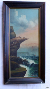 Flagstaff Hill Maritime Museum and Village
Painting - Oil painting, W. Langley-Taylor, Eagle Rock, Warrnambool, Vic, Late 19th to early 20th century
This painting is one of a pair of large paintings by W. Langley-Taylor in our collection. Currently, no further information has been found about the artist but research is ongoing. The subjects of these paintings are seascapes of notable areas of the coast on each side of Port Phillip Bay, south of Melbourne, Victoria. This painting is of Eagle Rock, Warrnambool, which is on the west of Port Phillip Bay. Eagle Rock is located about 400 metres west of Thunder Point, near Shelly Beach. The painting includes the rocky cliff formations looking east towards the Warrnambool Breakwater. The walk from the Thunder Point car park westwards to Shelly Beach has been popular over the decades with residents as well as tourists. Many photographs include the rock, with varying backgrounds depending on the angle of the camera. It is a popular dive site for locals and visitors, in calm weather! The site can be approached by boat from the open sea in favourable conditions, and there is plenty of native marine to be seen in this marine sanctuary. This part of Warrnambool’s rugged coastline is unprotected from the Southern Ocean with its wild icy winds and high seas. The painting’s crashing waves and the northerly direction of the smoke on the steamship sailing north show the effect of the southerly wind. INSCRIPTIONS “Mrs M Irby” and “980/Regency” The significance of the inscription “Mrs M Irby”, on the back of each of the two paintings, has not yet been discovered. Perhaps she was connected with the ship or shipping company “Irby”. A ship named “Irby”, built in Merseyside, Liverpool in 1881 by R & J Evans, Birkenhead. It was a four-masted iron ship built for the White Star Line. Henry Wilson Hewitt bought her in 1882, then later she was owned by Chadwick & Pritchard. In 1888 she was registered under the Irby Ship Co. Ltd. (trading as J. Joyce) in Liverpool. In 1912 Galgate Co. Ltd owned her. She traded between London, England and Australia, and is recorded as being in Melbourne and Hobart. In 1919 the Irby was destroyed by a mine when on her way to England. Or perhaps her name and the inscription in pencil “980/Regency” on the Eagle Rock Warrnambool, painting could be a delivery address for the paintings, perhaps an apartment in a hotel. This painting is significant geographically for its representation of the coastal scenery of Victoria, Australia. It is also significant as one of a pair of paintings of seascape, one at sites each side of Port Phillip Bay. The painting is significant historically as an example of late 19th and early 20th methods and materials used to construct a painting’s frame. Painting oil on board in a dark wooden frame, portrait orientation. Seascape of rock formation and cliffs, two yachts, a two-masted steamboat with red funnel and smoke, flying birds, high waves breaking onto rocks, blue sky with clouds, some tinted pink.. The title is painted on lower left corner and the artist, W. Langley-Taylor, has signed his name on lower right. The inscription on the back is a handwritten script in red crayon or thick red pencil. The board is held in place inside the timber frame with small, dark metal tacks around all sides. Metal eyes join the wire to the frame. Small round, dark metal nail heads are dispersed around the frame and there is a change of colour on both the board and the wood of the frame. Painted on front “W.LANGLEY-TAYLOR.” and “EAGLE ROCK, WARRNAMBOOL, VIC.” Handwritten on back “Mrs. M. Irby” and “980 [underlined] Regency”flagstaff hill, warrnambool, shipwrecked coast, flagstaff hill maritime museum, maritime museum, shipwreck coast, flagstaff hill maritime village, great ocean road, eagle rock warrnambool, w. langley-taylor, oil painting, wall decoration, seascape of victoria's coast, mrs m irby, art, seascape, pair of paintings -
 Parks Victoria - Wilsons Promontory Lightstation
Stretcher
Made of canvas and bamboo slats with hemp ropes, adjustable canvas straps and metal buckles and rings, the rescue stretcher was used for carrying an injured person. According to the Powerhouse Museum, the stretcher and was ‘designed to support and carry an injured person in circumstances where the person has to be lifted vertically’. Known as the ‘Neil Robertson stretcher’, it was developed in the early 1900s by John Neil Robertson as a lightweight rescue device and was modelled on Japanese bamboo litters. An identical stretcher is held in Sydney’s Powerhouse Museum and is thought to date between c.1967 and 1999. The museum’s statement of significance for the unique stretcher elaborates on its cultural values: The canvas is wrapped around the patient and secured with strong canvas straps. A lifting rope is attached to a ring above the patient's head, while a guideline is tied near the ankles and used to stop the stretcher swaying as it is hoisted up. This style of stretcher was specifically designed for use on ships, where casualties might have to be lifted from engine-room spaces, holds and other compartments with access hatches too small for ordinary stretchers. The original name of the Neil Robertson stretcher was 'Hammock for hoisting wounded men from stokeholds and for use in ships whose ash hoists are 2 ft. 6 in. diameter'. Since those times the Neil Robertson stretcher has also been used in factories and mines and for other emergency rescue situations. It is still possible to buy this type of stretcher although the slats are now more likely to be made of wood. The example in the Powerhouse collection was amongst several items of obsolete first aid and rescue equipment donated by the electricity generation company Delta Electricity. It would have been used - or at least been on stand-by - at the company's Munmorah Power Station or the associated coal mine on the Central Coast of New South Wales. Industrial sites and mines are extremely dangerous work places. Throughout the 20th century to the present there has been a drive, especially in developed countries like Australia, to improve workplace safety. Measures taken to reduce injuries and deaths have included safer industrial equipment, safer work practices, staff training, and the ready availability of accident and emergency equipment.It was also used throughout WWI and WWII. There are two other examples of the stretcher are known in Parks Victoria heritage collections. Canvas and bamboo stretcher with straps and buckles. Hemp ropes are attached to the stretcher.