Showing 1802 items
matching subdivision
-
 Glen Eira Historical Society
Letter - St. James Parade, 11, Elsternwick
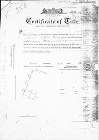
Five documents all relating to the estate of Lillian Jean Adami of 11 St James Street, Elsternwick A request for a sworn valuation on the auction price for the property and the contents from office of Public Trustee. A carbon copy of sworn valuation of the property and contents by Wv Scott FCIV. Includes an inventory and valuation of furniture and effects on and about the property, working notes on the valuation of the building and a copy of the Certificate title for Lot 16 subdivision 9341 on the western side of St. James Parade, Elsternwick Vol 5268. Folio 496 includes site plan and encumbrances referral.simmons s.p., plans, point nepean road, adami lillian jean, house, elsternwick, scott wv, st. james parade, prahan, estate agents, county of bourke -
Glen Eira Historical Society
Letter - Lempriere Family
Four items about the Gardenvale Station Estate: 1. Photocopy of correspondence dated 19/11/1925 to the Town Clerk from C A Lempriere regarding a photograph at Gardenvale railway station estate : land previously owned by John T Lempriere (former mayor). 2. Photocopy of photograph showing Gardenvale station estate land before subdivision. 3. Document of thanks from Councillors re photograph in minutes ref. 2362-25. 4. Photocopied photo, with brief text about auction and of view of the Gardenvale Station Estate.lempriere c a gardenvale railway station kooyong road point nepean road lempriere john t gardenvale station estate subdivisions , hall councillor , wharington councillor, mackay g j (auctioneer), houses -
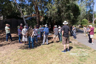 Eltham District Historical Society Inc
Photograph, Peter Pidgeon, Heritage Excursion: Woodridge Wander, 6 March 2021
The Woodridge Estate was a major residential subdivision that was developed in many stages in the 1970s and 80s. It extended easterly from the older residential area of Eltham into what had previously been largely privately owned bushland. The subdivision design took into account the steep topography and resulted in large blocks that enabled preservation of much of the tree cover. It included a number of small parks and walkways and the one kilometre long Woodridge Linear Park. A bushland area left as a proposed school site later became the Pauline Toner Butterfly Reserve for preservation of the rare Eltham Copper Butterfly. This walk explores some Woodridge streets as well as the linear park and butterfly reserve, a hilly walk of about 3 km and includes some moderately rough tracks. Permission to visit the external grounds of two private properties to view heritage listed houses not visible from the street was granted. The walk commenced at 2pm at the access to Woodridge Linear Park in Grove Street just east of the Eltham East Primary School (Melway ref 22 B4). This free walk was open to the general public as well as Society members. Whilst COVID restrictions did not require the wearing of masks in the open, masks had to be carried and all attendees registered with name and contct number.Born Digital (41 images)covid-19, eltham, eltham district historical society, heritage excursion, woodridge estate -
 Ringwood and District Historical Society
Article - Newspaper Clipping, Land Sale Advertisements, Golden Hill Estate, Ringwood - 1965, 1966, and Plan of Survey of Lot 8, Mullum Mullum Road Ringwood, 1970
Newspaper clippings from Melbourne Sun newspaper (11th December 1965 and 15th January 1966) advertising sale of land - Golden Hill Estate, Ringwood, with summary of features and aerial photograph including artistic representation of street layout. Subdivision includes Mullum Mullum Road, Sonia Street, Jill Court, Linda Drive, Eve Court, Alma Court, and Jacynthe Court. Attachments include reference to Lot 46 as site of original Peter Vergers' orchard residence and subsequent 1970 surveyor's Plan of Survey of Lot 8 Mullum Mullum Road Ringwood, LP 67513, Cert of Title 8581/429.Agent - Aaron, King & Co., Suite 2, 33 Queens Road, Melbourne. (Phone) 26-2443, A.H. 850-2195. Plan of Survey signed on 25.7.1970 by Roger M. Gamble, Land Surveyor, 28 Summit Crescent, Ringwood 3134. -
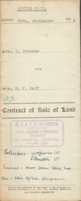 Bendigo Historical Society Inc.
Document - H.A. & S.R. WILKINSON COLLECTION: CONTRACT OF SALE
Contract of sale of land dated 26th September, 1955 between Mrs. I. Forster (seller) and Mrs. E.V. Raff (buyer) for land being lot 2 on plan of subdivision No.3905 lodged at the office of titles being part of Crown allotment 8 section 8 portion B described in certificate of title volume 4045 folio 961 situate No. 142 Myrtle Street, Bendigo. Together with right of carriage way over land at rear of property with weatherboard dwelling and all sundry, also all floor coverings, blinds, curtains, electric light fittings and shades and 'Pope' washing machine. Price 3,200 pounds.organization, business, h.a. & s.r wilkinson real estate -
 Bendigo Historical Society Inc.
Document - H.A. & S.R. WILKINSON COLLECTION: CONTRACT OF SALE
Contract of sale of real estate between Mr. R.A. Santon (vendor) and Mr. A.L. & A.K. Stringer (purchaser) dated 17th, July, 1962. Solicitor for vendor: Messrs. E.S. Cahill & Son, View Street, Bendigo. Solicitor for purchaser: Messrs Watson, James & Rogers, Bull Street, Bendigo. Property: Lot 21, Mahon Avenue, Bendigo, being lot 21 on plan of subdivision no. 31961 lodged in the office of titles parish of Sandhurst and being the whole of the land comprised in certificate of title volume 8310 folio 930 having a frontage of 53 feet to Mahon Avenue by a depth of 120 feet. Price 550 pounds.organization, business, h.a. & s.r wilkinson real estate -
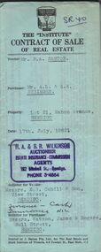
 Bendigo Historical Society Inc.
Document - H. A. & S. R. WILKINSON COLLECTION: CONTRACT OF SALE
Contract of sale of real estate dated 17th September, 1960 between Mr. H. H. Sullivan (vendor) and Mr. C. W. & Mrs. F. L. Silk (purchaser). Solicitor for vendor: Messrs. Watson, James & Rogers, Bull Street, Bendigo. Solicitor for purchaser: Tatchell, Dunlop, Smalley & Balmer, Williamson Street, Bendigo. Property: Lot 1 Poplar Street, Golden Square being lot 1 on plan of subdivision No. 56050 lodged in the office of titles and being part of Crown allotment58 section 32A at Bendigo described in certificate of title volume 8131 folio 745. Price 325 pounds.organization, business, h.a. & s.r wilkinson real estate -
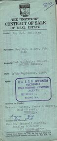
 Bendigo Historical Society Inc.
Document - H. A. & S. R. WILKINSON COLLECTION: CONTRACT OF SALE
Contract of sale of real estate dated 18th December, 1962 between Mr. J. Coco & Mr. M. Storti (vendor) and Mr. E. A. & Mrs. D. J. Sprigg (purchaser). Solicitor for vendor: Watson, James & Rogers, Bull Street, Bendigo. Solicitor for purchaser: E. S. Cahill & Son, View Street, Bendigo. Property: Lot 2 McKenzie Street West, Golden Square being lot 2 on plan of subdivision No. 56256 land described in certificate of title volume 8375 folio 655. Price 4,000 pounds. Attached 5 letters between the parties and tradies detailing jobs to be done on the property.organization, business, h.a. & s.r wilkinson real estate -
 Bendigo Historical Society Inc.
Document - H. A. & S. R. WILKINSON COLLECTION: CONTRACT OF SALE
Contract of sale of land dated 5th November 1955 between Mr. L. H. & Mrs. M Davis (vendor) and Misses T. A. & I. Pithie (purchaser). Solicitor for vendor: H. E. Every. Solicitor for purchaser: Neal Woodward. Property: Lot 4 on plan of subdivision No.21517 lodged in the office of titles being part of Crown allotment 351 section E, land described in certificate of title volume 7731 folio 178, together with 5 room brick dwelling also all floor coverings, blinds, curtains, electric light fittings and shades, electric stovette and stand. Price: 6,000 pounds.organization, business, h.a. & s.r wilkinson real estate -
 Bendigo Historical Society Inc.
Document - H. A. & S. R. WILKINSON COLLECTION: CONTRACT OF SALE
Contract of sale of land dated 30th August 1955 between Mr. E. M. Hopper (vendor) and Mr. J. H. & Mrs. E. E. Parker (purchaser). Property: land being part of Crown allotment3 section 5A having a frontage of 38 feet 8 inches as shown on plan of subdivision consented by the city of Bendigo on Wednesday 6th August, 1955 and situate block 5, No. 110 Penton Street, Golden Square, together with 5 roomed weatherboard dwelling as inspected to be completed similar to Mrs. James property 650 High Street, Golden Square. Price: 3,200 pounds. .organization, business, h.a. & s.r wilkinson real estate -
 Kew Historical Society Inc
Plan, Melbourne & Metropolitan Board of Works : Borough of Kew : Detail Plan No.1297, 1904
The Melbourne and Metropolitan Board of Works (MMBW) plans were produced from the 1890s to the 1950s. They were crucial to the design and development of Melbourne's sewerage and drainage system. The plans, at a scale of 40 feet to 1 inch (1:480), provide a detailed historical record of Melbourne streetscapes and environmental features. Each plan covers one or two street blocks (roughly six streets), showing details of buildings, including garden layouts and ownership boundaries, and features such as laneways, drains, bridges, parks, municipal boundaries and other prominent landmarks as they existed at the time each plan was produced. (Source: State Library of Victoria)This plan forms part of a large group of MMBW plans and maps that was donated to the Society by the Mr Poulter, City Engineer of the City of Kew in 1989. Within this collection, thirty-five hand-coloured plans, backed with linen, are of statewide significance as they include annotations that provide details of construction materials used in buildings in the first decade of the 20th century as well as additional information about land ownership and usage. The copies in the Public Record Office Victoria and the State Library of Victoria are monochrome versions which do not denote building materials so that the maps in this collection are invaluable and unique tools for researchers and heritage consultants. A number of the plans are not held in the collection of the State Library of Victoria so they have the additional attribute of rarity.Original survey plan, issued by the MMBW to a sewage contractor with responsibility for constructing sewers in the area identified on the plan within the Borough of Kew. The plan was at some stage hand-coloured, possibly by the contractor, but more likely by officers working in the Engineering Department of the Borough and later Town, then City of Kew. The hand-coloured sections of buildings on the plan were used to denote masonry or brick constructions (pink), weatherboard constructions (yellow), and public buildings (grey). This plan of Kew encompasses the area bounded by Barkers Road, High Street and Stevenson Street. Because of the angle created by High Street, a number of houses on the northern side of High Street are shown. The area is dominated by one of the great original landholdings in Kew, described here as the ‘Findon Paddock’. ‘Findon’, the house from which the name of the paddock was taken fronts Stevenson Street and was clearly a rambling structure. The best-known occupant of Findon was Henry ‘Money Miller’ who bought the house in 1871. Miller was a member of Victoria’s first parliament and assisted in the framing of its constitution. Findon was to be subdivided as early as 1912, when the Findon Subdivision was advertised to be sold by auction. In the plan of the subdivision, the original house is not shown, so, presumably it had previously been demolished. Fincham & Son moved the organ, built by Henry Willis, which was installed in the house, first to ‘Whernside’ in Toorak, and later to the Box Hill Methodist Church.melbourne and metropolitan board of works, detail plans, mmbw 1297, cartography, kew (vic.) — municipal collection -
 Glen Eira Historical Society
Article - St. Andrew’s Presbyterian Church, North Road, Gardenvale East
Handwritten document giving brief details on wording on foundation stone of St. Andrew’s church, undated and author unknown. Photocopy of pamphlet produced for the stewardship campaign 1957 for St. Andrew’s Presbyterian Church Gardenvale East, with several photos. It includes history as well as current situation at 1957. Photocopied notes and photo of the Army Hut used by Gardenvale Primary School in 1921 only as donated by church for and year then Reverted back to church use. Photocopy of letter to Glen Eira News and City Council re-proposed subdivision of church land from Robert W. Sinclair.st. andrew’s presbyterian church, foundation stones, nicoll l.a., heathcote-fletcher a. rev., north road, seach street, smith a. f.h. rev., mcneilage alex rev., gardenvale east, caulfield south, younger street, gardenvale east church, nicholls rev., rowlands w. rev., lang walter, sunday schools, yeaman f.e. rev., brown f.e., brick, towers, manse, choirs, groups, smith mrs., curtis e.e., morse roger, marryatt harry, pegler adrian, savill t., south caulfield, gardenvale primary school, sinclair robert w., dakin ms., campbell felicity -
Glen Eira Historical Society
Article - Maysbury, Maysbury Avenue, 1, Elsterwick
An article in Melbourne Bayside Weekly, October 20, 2010 by architect Neil Clerehan giving the history of Maysbury and describing some of its architectural features, also a description of the building and grounds subdivision into individual houses in the newly created Maysbury Avenue and the building into seven individual flats and subsequent addition of seven more apartments. Included in the article are three coloured photographs of one of the exterior of the building and two of individual rooms in apartment No.7. Also three real estate advertisements including three coloured photographs, one of interior of apartment and two external views of Maysbury dated 2009 and 2010.maysbury, elsternwick, maysbury avenue, south road, labassa, gatsby, burreel avenue, grimwade house, glenhuntly road, glenmayne, biggin and scott real estate, mansions, architectural features, flats, bedrooms, living rooms, kitchens, bathrooms, arches, ceilings, fireplaces, architects, land titles, gardens, sheds, victorian style, italianate style -
Glen Eira Historical Society
Book - Local Government Act First Report of the Assistant Commissioner of Roads and Bridges
This file contains 1 item: 1/The Local Government Act, First Report of the Assistant Commissioner of Roads and Bridges, printed by order of the Victorian Legislative Assembly on 08/03/1865. The document is the first annual report of John Steavenson, Assistant Commissioner of Roads and Bridges under s330 of the Local Government Act no. 176 (1863), and relates to transactions which took place from 02/09/1863 to 31/12/1864. The report outlines operations carried out by the Department of Roads and Bridges in this period. In the Glen Eira area this includes: separating electoral subdivisions of single districts (Moorabbin), adding detached portions of territory to road districts and shires (Caulfield), appointing of and altering in polling places, appointing of polling places for ridings of shires and subdivisions of road districts (Moorabbin), preparing and transmitting of forms of books also of pro forma accounts for guidance of local bodies in keeping their accounts, appointment of main roads, construction of a main road, ‘Dandenong’, in the Caulfield and Gardiner districts, proclaiming of Common Toll Roads, names of and security given by Managers of Common Toll Roads. The report also gives some information about the Shire of Caulfield, which contained 24 road districts and 340 rate payers in 8¼ square miles, and the Shire of Moorabbin, which contained 62 road districts and 713 rate payers in 30 square miles.local government act, assistant commissioner of roads and bridges, legislative council, caulfield historical soceity, steavenson john, sullivan j. f. the honourable, caulfield, moorabbin, road districts, point nepean road, nepean highway, dandenong road, princes highway, brown edwin, osher joseph, cosgrove john, ferres john, roads and bridges offices, caulfield roads district, moorabbin roads district, road construction and maintenance, roads and streets, acts of parliament -
 Ringwood and District Historical Society
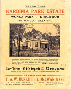
Flyer, Land Sale Brochure, Kardinia Park Estate, North Ringwood, Vic. - circa 1948
Folded buff-coloured land sale advertisement for Kardinia Park Estate in Warranwood area of North Ringwood, including terms of sale, area map, layout plan of the estate, and summary of local facilities and services. Front page features photograph of a man and dog in front of a house captioned as Lot 1 on four acres shown on the estate layout as cnr of Brysons Road and Range View Parade (later Omeo Parade). Second page includes bushland swimming pool photograph and promotional information for prospective buyers.Subdivision includes Kardinia Crescent, Wonga Road, Brysons Road, Range View Parade (later Omeo Parade), Motor Coach Road (later Wonga Park Road, then Warranwood Road). (Agent/s) T.A.W. Burkitt, Main Street, Ringwood, Phone (9 to 6) Ringwood 242, Evenings, Ringwood 157, and J. McEwan & Co, 317 Collins Street, Melbourne, Phone 6750 Central. -
 Bendigo Historical Society Inc.
Document - H.A & S.R. WILKINSON COLLECTION: CONTRACT OF SALE
Contract of sale dated 29th April, 1959 between Mr. L.C. Powell (seller) and Mrs. R.E. Steffan (buyer). Solicitor for vendor: Messrs. Tatchell, Dunlop, Smalley & Balmer, Williamson Street, Bendigo. Solicitor for purchaser: Messrs. Hyett, Willis & Hyett, Bull Street, Bendigo. For property at No. 8 Thomas Street, California Gully, Bendigo being lot 3 on plan of subdivision No. 17846 lodged in the office of titles being part of Crown allotment 563 section K land described in certificate of title volume 7150 folio 604, together with linos, blinds, curtains and electric light fittings and shades. Price 1,300 pounds.organization, business, h.a. & s.r wilkinson real estate -
 Bendigo Historical Society Inc.
Document - H. A. & S. R. WILKINSON COLLECTION: CONTRACT OF SALE
Contract of sale of real estate dated 18th December, 1963 between Mr G. A. & Mrs. N M. Wells (vendor) and Mr. H. G. & Mrs. M. E. Stephenson (purchaser). Property: 82 Hargreaves Street, corner Arnold Street, Bendigo, being lot 2 on plan of subdivision No. 28382 lodged in the office of titles, being part of Crown allotment 15 section 92C land described in certificate of title volume 4335 folio 826 together with floor coverings, blinds, curtains, electric light fittings and shades, gas stove in kitchen and gas fire heater in lounge room. Price: 3,250 pounds.organization, business, h.a. & s.r wilkinson real estate -
 Bendigo Historical Society Inc.
Document - H. A. & S. R. WILKINSON COLLECTION: CONTRACT OF SALE
Contract of sale of real estate dated 18th September, 1963 between Mr. A. J. & Mrs. D. M. Wright (vendor) and Mr. M. W. & Mrs. C. J. Smith (purchaser). Solicitor for vendor: Watson, James & Rogers, Bull Street, Bendigo. Solicitor for purchaser: Watson, James & Rogers, Bull Street, Bendigo. Property: Kirby Street, Golden Square being lot 10 on plan of subdivision No. 52827 lodged in the office of titles being part of Crow allotment27 section 58B at Bendigo, together with all floor coverings, blinds, curtains, electric light fittings and shades, gas stove and electric heater in kitchen. Price: 4,300 pounds.organization, business, h.a. & s.r wilkinson real estate -
 Whitehorse Historical Society Inc.
Document, Deep Creek Road, 13/04/1929
Photocopy of Certificate of Title Vol 5525 Fol. 1104883, land fronting on Deep Creek Road, Mitcham being lot 136 on Plan of Subdivision No 8022, part of Crown Portion 128A, Parish of Nunawading, County of Bourke, in the name of Francisco Schwerkolt, 13 April 1929, on her death in 1946, probate granted to Charles Victor Schwerkolt.Passed to Frances Dora Hogan in 1947, Alice Maud Everitt in 1950, Charles Edward Everitt and Muriel Eileen Priscilla Edwards in 1953, Stanley Ernest Edward Dawson and Iris Rae Dawson in 1973, Glenn Joseph Benham and Judith Rae Benham in 1975 and Ernest Victor Copling and Barbara Ruth Copling in 1980.deep creek road, mitcham, schwerkolt, francesca, charles clarence victor, schwerkolt cottage, hogan, frances dora, everitt, alice maud, charles edward, edwards, muriel eileen priscilla, dawson, stanley ernest edward, iris rae, benham, glenn joseph, judith rae, copling, ernest victor, barbara ruth -
Whitehorse Historical Society Inc.
Newspaper - Article, Old spacious home key to past Mitcham, 24/01/1968
Article in Nunawading Gazette about 'Windouran', a spacious home unchanged since its picture was used to boost Mitcham's first subdivision sale. It has been divided into 2 flats but still looks stately. In 1915 70 big home sites were sold in an area bounded by Mitcham Road, Halls Parade, Orient Avenue and Vernal Avenue. The estate was known locally as 'Mother Foster's Estate'. Mr James Thatcher brought the brochure to the Gazette - his grandfather, Joseph Lloyd bought land at that sale. David Lloyd (Thatcher's uncle) lived there. James Thatcher had an orchard at that time on a hill above Centre Road, Vermont.houses, windouran, windouran drive, mitcham, mitcham, thatcher, james, mitcham road, mitcham, halls parade, mitcham, orient avenue, mitcham, vernal avenue, mitcham, mother foster's estate, lloyd, joseph, lloyd, david, simon, kingsley -
 Falls Creek Historical Society
Document - Orest Frueauf Letter - Support as Representative Of Commercial Interests On Committee Of Management
Bob (Herman) Hymans (a former member of the Royal Netherlands Navy) was born in Bloemendaal, Holland on 30th September 1922. During World War II he fought against the Japanese in the Dutch East Indies (now Indonesia) and was imprisoned in Changi and on the Burma Railway. After gaining qualifications as a Ski Instructor, Bob arrived in Falls Creek in July 1950. Working as an Instructor and Supervisor at Bogong Lodge, Bob decided his future was in accommodation. He was successful in negotiating an indenture for land from the State Electricity Commission (SEC). It took Bob two years to build his Grand Coeur Chalet but, tragically, it was burned down in August 1961. Bob also built the first Chairlift in Australia. This was a single chairlift and the structure was built from wooden electricity poles. He was constantly full of new ideas and proposals for the village. Bob Hymans died on 7th July 2007. This Collection of documents and letters tells the story of Bob's endeavours to develop Falls Creek into the ski village it is today.This item is significant because it documents actions taken by the Falls Creek Tourist Area Management Committee in their role overseeing the Tourist Area.Letter from Orest Frueauf to Bob Hymans regarding the upcoming Management Committee election. He requested Bob's support in Orest's quest to be elected as the representative for those with commercial interests in Falls Creek. Orest raised concerns related to the release of further subdivisions in the Village which would double its size and put pressure on sewerage, water supply and roads. Other ongoing issues he referred to included oversnow transport, new tows, fire protection, finance, internal roads, search and rescue, publicity and booking arrangements. Orest believed that those with commercial interests needed to have a common approach and reliable representation on the Management Committee.falls creek tourist area management committee, falls creek administration, bob hymans -
 Eltham District Historical Society Inc
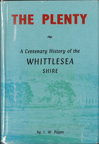
Book, J. W. Payne, The Plenty: A Centenary History of the Whittlesea Shire, 1975
This book traces the one hundered years of the development of the Shire of Whittlesea, from the discovery by Hume and Hovell in 1824 to the time of the centenary in 1975. The intervening years saw the settlement of Vandemonians, Sydney-siders, English, Scots, Irish and Germans, Black Thursday, the building of the Yan Yean Reservoir, the Plenty River flour millls, the timber industry, fruit-growing and export and vineyards. Personalities and pubs, subdivisions, stories of the Findon Hunt Club and various Shires including Epping. History of education and transiton from rural to urban in the south of the Shire. The work is illustrated with maps and photographs. The Shire is now the City of Whittlesea and is an immediate neighbour to the north of the Shire of Nillumbik. shire of whittlesea -
Glen Eira Historical Society
Plan - Nettalie
Land Victoria title documents vol 339 folio 763A and 764 relating to the property Nettalie on the corner of Balaclava and Orrong Rds. These documents detail the history of the land dealing relating to Nettalie and the neighbouring estate Harleston listed as parcels 209a and 209b. These dealing include grants of land, mortgages and conveyance (transfers). The documents include photocopies of handwritten notes of the title history date 1870; a partial copy of an instrument of conveyance dated 1863 and the original titles of the land owned at various times by William Noall, Alfred Shaw, Alfred Desailly and Sir Frederick Grimwade. Within the documents are various hand drawn and printed diagrams of the subdivisions.forsyth william, noall william, cutts william henry, shaw alfred, hailes george button, bakewell john, pascoe john randle, little william, fraser alexander, powell walter, whitney john, hodgeson richard, trollope william thomas, keep edward, blundell mary, carr john bonney, farie claud, fosberry john wallcott, davies john, brady michael, lloyd frederick, turner george, desailly alfred, grimwade frederick s sir, parish of prahran, county of bourke, caulfield north, st kilda east, balaclava road, orrong road, nettalie, netley house, harleston, melbourne grammar school, land subdivision, land sales, land titles, legal documents, homestead, schools, houses -
Glen Eira Historical Society
Map - Cantala
Six pages of handwritten notes, undated and unattributed, detailing the history of the subdivision and demolition of Cantala, Dandenong Road, 40, Caulfield. The notes, which include a list of references, detail the main auction on 21/05/1938 and prices paid for the allotments. Also included in the file are photocopies of three auction posters for the 21/05/1938 auction in 32 allotments. Two of the posters are small and one of these includes a map (107mm x 110mm) of the Cantala Estate. The other poster is spread across three A4 pages and includes a map and plan (204mm x 110mm) of the allotments. There is an extra copy of the final page of this larger poster.miller septimus, miller helen m, mcintyre angus, miller n a, crouch h c, cantala, dandenong road, wiora, alma road, waiora road, findon avenue, cantala avenue, caulfield, caulfield north, st kilda east, yeo grosthwaite and co, abercromby and beatty pty ltd, mansions, land subdivision, house auctions, auctioneers, land sales, land values, architectural features, gardens, advertisements, racehorses, road construction and maintenance, surveyors, lawyers, minute books, trams -
 Kew Historical Society Inc
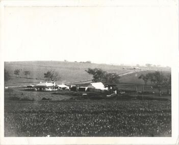
Photograph, Kilby Farm, Kew East
Kilby Lodge (c.1845-c.1922). William Oswin purchased Crown Land Lots 52 & 53 in 1845. These lots ran north from an old bullock track [later Kilby Road] to the Yarra, and east to Burke Road. Oswin purchased a neighbouring Lot in 1851, separated by the bullock track from the rest of the farm. Oswin built ‘Kilby Lodge’ and, with his brother, farmed dairy cattle on the site. Oswin’s descendants owned the farm into the 1890s. New subdivisions of Kilby and neighbouring farms in the 1920s changed the rural nature of north Kew. Housing and large recreation reserves replaced dairy farms and market gardens. This work forms part of the collection assembled by the historian Dorothy Rogers, that was donated to the Kew Historical Society by her son John Rogers in 2015. The manuscripts, photographs, maps, and documents were sourced by her from both family and local collections or produced as references for her print publications. Many were directly used by Rogers in writing ‘Lovely Old Homes of Kew’ (1961) and 'A History of Kew' (1973), or the numerous articles on local history that she produced for suburban newspapers. Most of the photographs in the collection include detailed annotations in her hand. The Rogers Collection provides a comprehensive insight into the working habits of a historian in the 1960s and 1970s. Together it forms the largest privately-donated collection within the archives of the Kew Historical Society.A panoramic photograph of Kilby (or Oswin's) Farm in East Kew."Kilby Farm when Oswins owned it. Commenced 1845."kilby farm, kilby lodge, william oswin, dorothy rogers, kew east -
Glen Eira Historical Society
Document - LAND SUBDIVISIONS 1880-1938
This file contains various subdivisions’ advertising flyers and cards. 1/Advertising announcement for auction sale of land (15 lots) at Glenhuntly Tram Terminus, to be held on 29/03/1924. Verso is map of the area (21.5cm x 29cm) 2/Advertising announcement for Trustees’ Auction sale of corner shop sites at Caulfield South near Glenhuntly Road and Hawthorn Roads, 15/11/1927 (21cm x 31cm) 3/Advertising pamphlet (A3) for auction of Cantala Estate, East St. Kilda (32 allotments), between Dandenong, Waiora, and Alma Roads, 21/05/1938 (15.5cm x 28.5cm) 4/Seven advertising postcards relating to auctions of land in Caulfield and Elsternwick. Only one (10 December 1881) with a year on it. (Each 13.5cm x 9cm) 5/Four more advertising postcards relating to auctions of land in Caulfield. One is dated 31/11/1880(?); another 09/02/1905. A third has no date. A fourth postcard is a map of allotments between Orrong, Kooyong, Seymour and Alison Roads, Caulfield, no date (each 13.5cm x 9cm) 6/Large advertising poster (41cm x 52.5cm) for ‘Carnegie Land Sale’ auction of the Egan Estate (near Carnegie Railway Station) on 12 April, no year given, but appears to be circa1900 7/‘Riddell Estate – Plan of Subdivision – Parish of Prahran’ mounted map, no date, probably c. 1900 (16cm x 21cm)auctions, house auctions, land subdivision, land development, subdivisions, caulfield, land subdivisions, east st. kilda, glenhuntly, carnegie, map, ‘new glenhuntly tram terminus estate’, ‘cantala estate’, ‘strathnaver estate’, ‘range estate’, ‘egan estate’, ‘riddell estate’ -
 Ringwood and District Historical Society
Map - State Aerial Survey, Dandenong Ranges Area, Parishes of Warrandyte and Ringwood - 1956
Map of central and southern areas of Ringwood and part of Ringwood East and Heathmont compiled by Dept of Lands and Survey, July 1956, from aerial photographs and Cadastral Survey information. Subsequent hand-drawn addition of streets showing layout of "Township of Ballyduffy Estate 1858-60", an earlier proposed subdivision that did not eventuate. (See attached 5009b Ballyshanassy_ Melbourne’s lost suburb.pdf for Ballyduffy historical naming relevance). Ballyduffy Estate streets include City Road, West Prussia Road, Duffy Street, Ireland Street, Evans Street, Victoria Street, Regina Street, Short Road, Prussia Road, Duffy Street East, Ireland Street East, Evans Street East, Chapman Street. Misc Topo 93 Sheet 22, Ringwood A4B2. Scale: 4 chains to 1 inch. Contour interval 20 feet. -
 Bendigo Historical Society Inc.
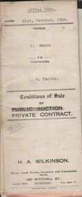
Document - H.A. & S.R. WILKINSON COLLECTION: CONTRACT OF SALE
Conditions of sale by private contract dated 21st. October, 1935 between J. Mahon (seller) and H. Taylor (buyer) for land situate Hodgkinson Street, Bendigo having a frontage of approx. 52 feet by a depth of approx. 108 feet, being parts of lots 6 and 7 on plan of subdivision registered No.13862 part of Crown allotments 6 and 7 section 38C land described in Crown grant volume 1502 folio 300225 and Crown grant volume 2642 folio 528242. Price 50 pounds. Attached receipt and plans to build house on that land (W. H. Ellis builder) for 500 pounds also attached detailed list of materials and labour.organization, business, h.a. & s.r wilkinson real estate -
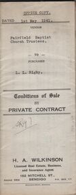 Bendigo Historical Society Inc.
Document - H.A. & S.R. WILKINSON COLLECTION: CONDITION OF SALE
Conditions of sale by private contract dated 1st May, 1942 Fairfield Baptist Church Trustees (William Alfred Newnham, Harry Marsh, Joseph Butters Hughes, James Arthur Dobson as trustees and sellers) and L.L. Rigby (buyer) for land having a frontage of 41 feet to the west of Arthur Street by a depth of 130 feet along the north side of Duncan Street being part of lot 81 on plan of subdivision No. 568 lodged in the office of titles and being part of Crown Portion 114 Parish of Jika-Jika County of Bourke described in certificate of title volume 3540 folio 707982 together with all buildings thereon and known as 98 Arthur Street Fairfield. Price 660 pounds.organization, business, h.a. & s.r wilkinson real estate -
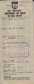 Bendigo Historical Society Inc.
Document - H. A. & S. R. WILKINSON COLLECTION: CONTRACT OF SALE
Contract of sale of real estate dated 22nd January, 1966 between Mrs. M. R. Potter (vendor) and Mr. M. L. Smart (purchaser). Solicitor for vendor: Messrs. E. S. Cahill & Son, View Street, Bendigo. Solicitor for purchaser: Messrs. Watson, James & Rogers, Bull Street, Bendigo. Property 3 Atkins Street, Bendigo being lot 1 on plan of subdivision No. 35034 lodged in the office of titles being part of Crown allotment 516B section K land described in certificate of title volume 8103 folio 921 together with all floor coverings, blinds, curtains and electric light fittings and shades. Price 2,500 pounds.organization, business, h.a. & s.r wilkinson real estate