Showing 6204 items matching "1936-1959"
-
 Glenelg Shire Council Cultural Collection
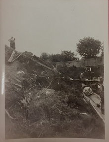
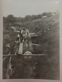
Photograph - Photograph - Main Breakwater construction, Portland, 1959
Port of Portland AuthorityFront: ' View-southwest showing test on pile. '1959'-Black biro Back: View Southwest showing test on pile. 1959- Black biroport of portland archives, main breakwater, construction, harbour development -
Glenelg Shire Council Cultural Collection
Administrative record - Quarterly Travelling Password - Ancient Order of Foresters, Nov-35
Printed piece of paper with quarterly password from 1 Feb 1936 to 30 Apr 1936. Also the Travelling Password, from 1 Nov 1935 to 31 Oct 1936 -
 8th/13th Victorian Mounted Rifles Regimental Collection
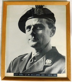
Photograph - Allard portrait
Lieutenant Colonel J.M. Allard was Commanding Officer of 8th/13th Victorian Mounted Rifles 1959 - 1962. He had served with 2/4th Armoured Regiment in WW2 The 8th/13th Victorian Mounted Rifles was raised as a regiment of the Royal Australian Armoured Corps on 1 May 1948 with Headquarters in Melbourne and squadrons in Sale, Benalla/Wangaratta and Albury. In 1955 Regimental Headquarters moved to Wangaratta and a second squadron was located at Albury. The Sale squadron transferred to 4th/19th Prince of Wales’s Light Horse. In 1977 8/13 VMR Regiment was reduced to an independent squadron A Squadron 8th/13th Victorian Mounted Rifles and in 1991 was linked with 4th/19th Prince of Wales’s Light Horse forming the VMR Squadron of that regiment. One of a collection of photographic portraits of Commanding Officers and Officers Commanding of the regiment/independent squadron from its inception in 1947 to its linking with 4th/19th Prince of Wales’s Light Horse in 1991. Framed black and white photograph of officer wearing black beret with emu plumes behind 8th/13th Victorian Mounted Rifles hat badge. Inscription panel on lower frame." Lt. Col. J.M. Allard ED 1959 - 1962 "military, allard, portrait, uniform -
 Kew Historical Society Inc
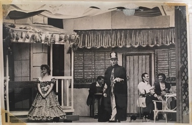
Photograph, The "Q" Theatre Guild, Blossom Time, 1959
The "Q" Theatre Guild was formed out of the Kew Light Opera Company in 1957. It marked the transition of the company that had initially been directed by Lance Nicholls to one directed by Beatrice Oakley. It continued to perform in the Kew Recreation Hall, but, with its demolition in 1960, and the opening of the new Kew City Hall in Cotham Road, moved its productions to that venue. Productions of the "Q" Theatre Guild included The Geisha (1957), Maritana (1958), They All Do It (1959), Blossom Time (1959), Love's A Luxury (1959), There And Back & The Bohemian Girl (1960), Die Fledermaus (1960), Gay Rosalinda (1961), The Land Of Smiles (1961), Kisses For A Kid & Hansel And Gretel (1961), Die Fledermaus (1962), Monsieur Beaucaire (1964), Macbeath or The Beggar's Opera, and So To Bed.The scrapbook of annotated photographs, programmes, and newspaper reviews of which this item is a part was assembled by Marion Tilley, wardrobe mistress for, and performer in, productions by the Kew Light Opera Company and the "Q" Theatre Guild. It is significant as a remarkably complete document of theatre performances in Kew, Victoria during the 1950s and 1960s. The scrapbook, and the items individually catalogued within it, have artistic and aesthetic significance within the history of performing arts in Victoria in the middle of the 20th Century. They have social significance in that they reveal socio-cultural values and preoccupations during the period. The records also act as a history of arts activities in the Kew Recreation Hall and later in the Kew City Hall as entertainment and community arts and music precincts.Black and white photograph of Jeanette Rayment in Blossom Time, a musical play in 3 acts adapted from the operetta Das Dreimäderlhaus by A.M. Wilner & Heinze Reichert. The performance was produced by Beatrice Oakley for The "Q" Theatre Guild in 1959 to coincide with Moomba. Music was provided by the Kew Philharmonic Society conducted by John Trotter. The set design is credited to Lachlan Stebbins. Marion Tilley, the creator of the scrapbook in which the photo is pasted, is given credit for designing and making the costumes. Jeanette Rayment performed the role of Therese.Marion Tilley, the creator of the scrapbook, wrote the name of "Jeannette Rayment" underneath the photograph.performing arts -- kew (vic.), scrapbooks, marion tilley collection, 'q' theatre guild, kew recreation hall, musical comedy -- melbourne -- victoria -
 Melbourne Legacy
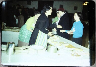
Slide, Intermediate Legacy Club Fete, 1959
A colour slide of a cake stall at a fete at Legacy House in Swanston St in 1959. There two ladies serving behind a table of food. Was with many other slides taken in the 1950s and 1960s. The slides have been photographed to make digital images and moved to archive quality sleeves. In many cases the original images were not well focussed and the digital image is the best available.A record of fetes being held at Legacy House.Colour slide of people serving food at a fete in Legacy House, in a brown Super Anscochrome cardboard mount.Printed in red ink 'ANSCOCHROME / View from this side / Made in Australia". Handwritten in blue pen "Cake Stall ILC Fete 1959". Imprinted by indentation "JUL 59". Imprinted with black ink '12'.ilc, fete -
 University of Melbourne, Burnley Campus Archives
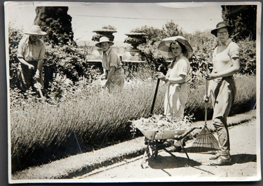
Album - CD black and white and sepia prints, Hilda Dance, 1935-1936
Hilda Dance (graduated 1936, staff 1941-47)2 copies of a CD with photographs taken by Hilda Dance. (1) 4 female students working in a flower bed. (2) 6 students at a flower show. (3) 4 female students on the lawn wearing dresses. (4) Group of students sitting on benches on the lawn. (5) 1936 Year Group. (6) 4 female students playing around on the lawn. (7) Students working near the Luffmann Ponds. (8) Newspaper cutting: 'She knows all the answers.' Student answering questions on a Vegetable Growing public day. (9) 2 female students playing around on the lawn. (10) Possibly an excursion to the zoo-man holding snake. (11) Female student bathing in the Yarra River. (12) Female student climbing a tree with steps cut into it, not Burnley. (13) Students bathing in the Yarra River. (14) 4 female students on the lawn wearing dresses. (15) Group of male students with lawnmower. (16) George Barnett/Russ? (17) Female student watering seedlings. (18) Group of male students with lawnmower. (19) Orchard Border. (20) Group of male students with lawnmower.hilda dance, female students, flower beds, students, flower show, luffmann ponds, students working outside, recreation, lawnmower, tree climbing, george barnett, orchard border, lily ponds -
Ringwood and District Historical Society
Attendance Book, Ringwood State School Mothers' Club Attendance Book 1957-1967, 1957-1967
Used by the Ringwood State School Mothers' Club for recording attendance at the Mothers Club meetings 1959 - 1967.Attendance book used by the Ringwood State School Mothers' Club for recording attendance at the Mothers Club meetings 1959-1967. Grey covered book with brown paper protective cover. Red cloth spine. All pages used.Ringwood State School Mothers' Club -
 Bendigo Historical Society Inc.
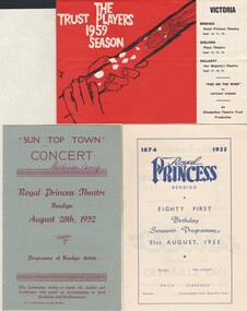
Document - GERTRUDE PERRY COLLECTION: PROGRAMMES FROM ROYAL PRINCESS THEATRE, 1952 - 1959
Book. 3 programmes for performances given at the Royal Princess Theatre, Bendigo. 1952, 1955 & 1959entertainment, theatre, royal princess, gertrude perry collection, royal princess theatre -
Whitehorse Historical Society Inc.
Document, Birth Certificate, 4/08/1959 12:00:00 AM
Birth Certificate for Nicholas Edward Fry 4 Aug 1959 at Box Hill & District Hospital.Birth Certificate for Nicholas Edward Fry 4 Aug 1959 at Box Hill & District Hospital.Birth Certificate for Nicholas Edward Fry 4 Aug 1959 at Box Hill & District Hospital.fry, nicholas edward, fry, albert gordon, fry, judith -
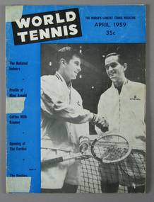 Tennis Australia
Magazine, 1959
Two issues of 'World Tennis' magazine, dating from 1959. Materials: Ink, Paper, Metaltennis -
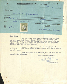 Melbourne Tram Museum
Letter, Melbourne & Metropolitan Tramways Board (MMTB), Use of X-2 tram, 11/08/1959 12:00:00 AM
Letter and receipt from Mr HA Warner, Secretary MMTB, to Mr R Prentice, for use of X-2 tramcar for proposed tour on Tuesday 1st September 1959. Letter dated 11 August 1959 and receipt dated 13/8/59.trams, tramways, tram hire, receipts, glenhuntly depot, tram tours -
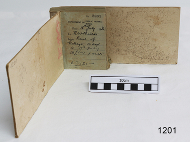 Flagstaff Hill Maritime Museum and Village
Financial record - Receipt Book, Department of Works and Mines Victoria, July 1936 (first record)
Establishment and Functions Prior to 1860, the Chief Secretary's Department had been responsible for the administration of the gold fields and associated mining activities. In November 1860 a Commissioner of Mines was appointed and a Department was established under his administration. For the period November 1861 to June 1863, the Postmaster General was responsible for the Mining Department. A Minister of Mines was again appointed in 1863. Responsibilities of the Department of Mines were: 1. Regulation of mining and related public works activities through the issue of miners rights, business and residence licences, mining leases, mineral and other prospecting licences 2. Superintendence of the activities of mining surveyors, registrars, wardens and Mining Boards. 3. Investigation of the state's geological structure, mineral wealth and underground water resources 4. Development of the mining industry 5. Supervision of the safe working of mines, machinery and quarries including checking the credential of mine managers, inspectors and operators 6. Regulation of the disposal of sludge and other waste products 7. Administration of the Victorian Mining Accident Relief Fund. Arising from its initial responsibility for the supply of water on the gold fields, the Department became responsible for rural water supply from the mid 1860s. Statutory responsibility for rural water works during this period rested with the Board of Land and Works. In 1865 the Waterworks Act gave the Board power to construct waterworks, purchase land, levy charges and lease or sell works, while the Public Loans Act 1865 empowered it to provide loans to local water trusts for waterworks. The actual administration of these statutory provisions was undertaken by the Victorian Water Supply Department which operated from 1865 to 1889 as a sub-department of the Department of Mines, from 1889 as a department in its own right, and from 1895 to 1909 as a sub-department of the Department of Mines and Water Supply. For a brief period from 1891 to 1893 the Department of Mines was also responsible for forests and, until 1880, for the Schools of Mines subsequently transferred to the Education Department. In 1895 the Department of Mines and the Victorian Water Supply Department were amalgamated to form the Department of Mines and Water Supply. A snapshot into social history around the 1930s when the Department of works and the Mines Departments were still linkedReceipt Book for the Department of Works; Mines. Receipt No 2801 - 3000. 1st receipt Number 2801, "18th July 1936, for Rent of Cottage: 14 days for 2 pounds, 2 shillings. The inscription on the back is signed by J F Condau in 13-3-33Printed on spine "GENERAL RECEIPTS / 15 / 2801 / TO 3000" Printed on each receipt 'DEPARTMENT OF / PUBLIC WORKS. / MINES." Fill in using ink pen "(DATE) 18th July 1936 / (TO) - - - shields' / BEING) Rent of / Cottage: 14 days / (TO) 17th July / @ (symbol for pound) 1-1. p. week / . (symbol for pound) 2:2:-"Inside cover there is some red pencil writing, words and figures unreadable. Handwritten on back cover "Numbers checked / and found corredt / J S Coudou (?) / 13-3-33" One some receipts "Wharfage / S.S. Koonara"flagstaff hill, warrnambool, shipwrecked coast, flagstaff hill maritime museum, maritime museum, shipwreck coast, flagstaff hill maritime village, great ocean road, department of works: mines, receipt book, rent 1936, imperial currency, living costs 1936, department of works, department of mines, j f condou, 1933, 13-3-33 -
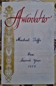 Hymettus Cottage & Garden Ballarat
Work on paper - Bookplate, Premium plate
The third Michael Taffe to live at Hymettus cottage Ballarat was dux of his class at the local parish school, St Patrick's Drummond St in 1958 and 1959. These mass produced premium plates were a popular insertion for such awards from their inception in Europe in the eighteenth century until the late twentieth century. The library collection at Hymettus includes examples from several Catholic schools, Wesleyan Sabbath Schools, Ballarat's McBains' High School, Ballarat College, Fintona in Camberwell and this from the Christian Brothers school at Drummond St Ballarat.Printed Awarded to and infilled with Michael Taffe Dux Second Year 1959.bookplates, premium plates, ballarat, christian brothers, fintona, weslyan sabbath schools, -
Port Melbourne Historical & Preservation Society
Plan - Additions, Port Melbourne Town Hall, City of Port Melbourne, 8 Jun 1936
Handrawn and coloured plan included with specifications for additions etc. to supper room at Town Hall, Port Melbourne, 1936.Both notes and plan signed by F.C. Cook, City Engineer - 3rd page of notes, top left hand corner of plan.port melbourne town hall, city engineers, fred cook -
 Ballarat Tramway Museum
Newspaper, The Courier Ballarat, "25 Years Ago", January 1936
Item from The Courier, 25 years ago, about the change of destination of "Orphanage" to "Victoria Street" and a note regarding the introduction of more "modern" second hand trams into Ballarat.Yields information about the change in the name of the Victoria St terminus.Newspaper clipping from The Courier, Ballarat January 1936, about Ballarat trams - titled "25 years ago" Two red arrows mark the item of interest.letters, tramways, public transport, victoria street, orphanage, destinations, new trams -
 Tarnagulla History Archive
Order of Service: Tarnagulla Presbyterian Church S.S. Anniversary, 1936
Donald Clark Collection.Order of Service for Special "Sunday School Anniversary" Service at Tarnagulla Presbyterian Church held on November 29, 1936. -
Tarnagulla History Archive
Receipt/Facsimile Book, Tarnagulla Loyal Garibaldi Lodge (1936-1937), 1936-1937
The Manchester Unity Independent Order Of Oddfellows was a friendly society beginning in England in 1840, and provided medical and other services to communities. MUIOOF became strong in gold-rush Australia, with many branches, or lodges, in country centres. Tarnagulla's Loyal Garibaldi Lodge was registered on 21 September 1861, and remained a vital part of the community for many decades. Like other Lodges, this fraternal organisation provided unemployment, sickness and funeral insurance for workers. It played an important civic role by providing financial security, a social outlet and an avenue for status advancement. By the last twenty years of the 19th century, Lodge activity was an important part of community life.Receipt/Facsimile Book for Member Contributions, Tarnagulla Loyal Garibaldi Lodge from March 1936 to April 1937.lodge, fraternal organisations -
 Phillip Island and District Historical Society Inc.
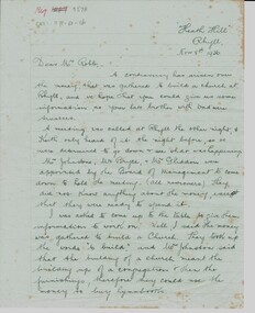
Letter, Letter re Rhyll Presbyterian church controversary over funds raised. G. McIllwraith to Mr Robb, 8/11/1936
Controversy over money previously raised to build a Presbyterian church at Rhyll, discussion of trustees and whether the money was for the building or furnishings eg hymn books. It discusses the future of the Island including a proposed Kraft cheese factory, a new bridge and shipping coal from San Remo.Historical6 pages of cream writing paper handwritten in black pen. Letter from Gwenda McIllwraith to Mr. Robb re use of monies raised to build a Presbyterian church at Rhyll."Heath Hill", Rhyll. Nov 8th, 1936. Dear Mr. Robbheath hill, gwenda mcillwraith, mr robb, presbyterian church, mr& mrs percy mcfee, mr johnston, mr bryce, mr gliddon, robert mcillwraith, rhyll, mr lock, kraft cheese co., chicory, coal mines -
 Warrnambool and District Historical Society Inc.
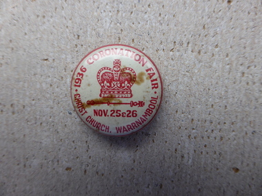
Badge - 1936 Coronation Fair Christ Church, 1936
A keepsake badge which relates to the tumultuous period of the English royal family with the death of George V when his son Edward V111 abdicated from the throne due to his involvement with divorcee Wallis Simpson. His brother Albert was crowned as King George VI on May 12 1937. This badge is of interest as the dates are a mere two weeks before the abdication. The Christ Church fetes and flower shows have been a part of Christ Church social and fundraising agenda since the 1890’s, with the ladies’ guild playing a large part in their organization and operation. This object has significance as it commemorates a long running and popular event on the social and religious calendar for the parishioners and people of Warrnambool. It also is linked to an event of world- wide interest.Small white badge with red writing and symbol of crown in the centre. Pin at the back.1936 Coronation Fair Christ Church Warrnambool Nov 25 & 26.christ church fete 1936, coronation fete warrnambool -
 Kew Historical Society Inc
Photograph, City of Kew, City of Kew, Cecil Street Drain, 1936
An original photograph donated to the Kew Historical Society by the City's Engineering Department preceding the amalgamation of Kew into the City of Boroondara. While not all of the photographs are of Studley Park, Kew or East Kew, each photo provides a fine snapshot of the work of local government engineering departments of the period. They reveal they types of labour conducted, the techniques used and the equipment and machinery in the possession of the local government authority. Historic and rare photograph of major public works in Kew in the 1930sPublic works. Men at work in the creek bed of Connor's Creek in Kew, while constructing the underground barrel drain. Connors Creek was one of the two main tributaries of the Yarra River in Kew. It originated somewhere near the grounds of Genazzano FCJ College. The barrel drain was finally completed in 1941 at a cost of £14,000. Inscription on reverse: "City of Kew / Cecil st drain / November 1936". public works (kew), roadmaking, engineering, city of kew (engineering department), connor's creek (kew), cecil street drain -
 Kew Historical Society Inc
Photograph, City of Kew, City of Kew, Cecil Street Drain, 1936
An original photograph donated to the Kew Historical Society by the City's Engineering Department following the amalgamation of Kew into the City of Boroondara. While not all of the photographs are of Studley Park, Kew or East Kew, each photo provides a fine snapshot of the work of local government engineering departments of the period. They reveal they types of labour conducted, the techniques used and the equipment and machinery in the possession of the local government authority. Historic and rare photograph of major public works in Kew in the 1930s.Public works. Men at work in the creek bed of Connor's Creek in Kew, while constructing the underground drain. Connor's Creek was one of the two main tributaries of the Yarra River in Kew. It originated somewhere near the grounds of Genazzano FCJ College. The barrel drain was finally completed in 1941 at a cost of £14,000. Inscription on reverse: "City of Kew / Cecil st drain / November 1936". city of kew, city of kew (engineering department), engineering, connor's creek (kew) -
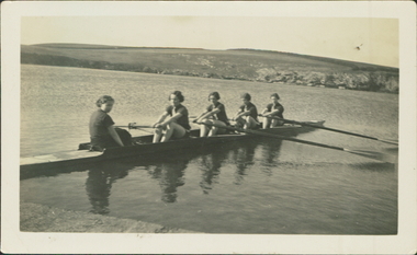 City of Warrnambool Rowing Club
Black and white photograph, 1936
There was a (Warrnambool) Ladies Rowing Club from about 1913. They were autonomous with their own shed, committee and coaches.The photograph is of a ladies crew in a sweep four. They are beside the bank of the Hopkins River, Warrnambool.The back of the photograph has "Before a training spin on the Hopkins River 1936".rowing, warrnambool, hopkins river, ladies rowing, warrnambool rowing club, warrnambool ladies rowing club, city of warrnambool rowing club, city of warrnambool rowing club -
 Kew Historical Society Inc
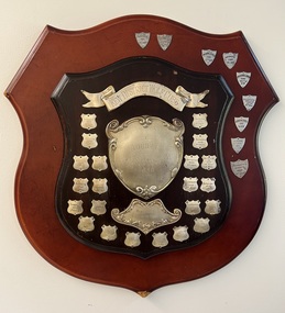
Award, Kew District Wolf Cubs Jubilee Sports Trophy, 1959-1994
Local and statewide significance to the history of Scouts (&Cubs) in Victoria.Combined inner original [1959] and outer newer [1981] wooden shield(s) with nickel plate (sic) shields listing 31 Kew Cub group winners of swimming competitions from 1959 to 1994 [missing shield for 1983] of the Kew District Wolf Cubs.Engraved: 'Kew District Wolf Cubs / Jubilee Sports Trophy 1958 / Presented by Willsmere Lodge". scouts - trophies, cubs - trophies, wolf cubs -- kew (vic), swimming trophies -
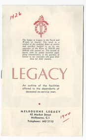 Melbourne Legacy
Booklet, Legacy. An outline of the facilities offered to the dependants of deceased ex-servicemen. (H26), 1944, 1953, 1959, 1961
A brochure explaining Legacy's work and the facilities they provide. It is aimed at the widows to inform them of what is available to them and it outlines the times for classes for the children. The earliest copy in 1944 included the charter of Legacy and headings in red printing. 'Melbourne Legacy offers friendship and help to the dependants of our departed comrades.' Headings included: Help and advice to mothers or guardians; Mothers' Club; Senior Widows' Club; Housing and repairs; Legal advice; Medical, dental and optical care; Education, Employment, Camps and holidays, Christmas party, Residences, Junior Legacy groups. The notation H26 in red pen shows that it was part of the archive project that was trying to capture the history of Legacy. See other editions at 01447.A record of how Legacy portrayed itself to the widows and children in 1944,1959 and 1961/8. Black and white brochure made of white paper, folded into a 8 page booklet. 01498.1 1944 (handwritten in red pen) 01498.2 April 1953 01498.3 April 1959 01498.4 October 1959 01498.5 June 1961 with markings to edit it for reprinting in July 1968Handwritten 'H26' and '1944' in red pen. 01498.5 has edits in blue pen to revise the content for republication.legacy promotion, history -
 St Patrick's Old Collegians Association (SPOCA)
Photograph - Culture, Sodality
-
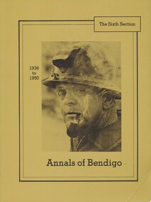 Bendigo Historical Society Inc.
Book - ANNALS OF BENDIGO 1936 - 1950 VOLUME 6, 1936-1950
Annals of Bendigo 1936 - 1950, The Sixth Section, Hard Cover. Chronicles of the years from 1936 to 1950. Published by The Sandhurst Building Society. (1981) Includes b/w photographs. White Lobrary sticker on spine - 0006 LOC Bendigo Historical Society Stamp inside front cover.Douglas Lockwoodbendigo, history, annals of bendigo -
Ballarat Tramway Museum
Newspaper, "All-Electrical Exhibition", 1936
Two Newspaper clipping contained within Reg. Item 2488, pages 97 and 99, titled "All-Electrical Exhibition", possibly from The Courier, Feb. 1936. The cutting features an exhibition by the SEC, from 29/2/1936 to 7/3/1936 in the Alfred Hall. Article on two pages notes early Ballarat power supply, ESCo, Benjamin Deakin, generating plant, policy of the SEC, statistics, the exhibition itself and the tramways in Ballarat and their rehabilitation. Note Item Not formally Numbered.Written notes in pencil.sec, electricity, exhibitions, esco -
Port Melbourne Historical & Preservation Society
Book - Bound copies, Port of Melbourne Quarterly, 1957 - 1959
Bound volume of Port of Melbourne Quarterly from 1957 to 1959, from an incomplete set 1951-1971piers and wharves, transport - shipping, immigration, melbourne harbor trust - port of melbourne authority -
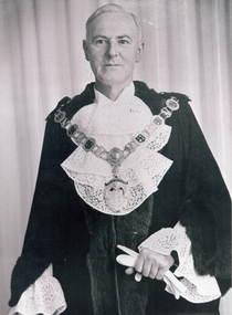 Whitehorse Historical Society Inc.
Photograph, Cr. Charles Ross - Mayor, 1959
Coloured Photograph of Cr. Charles Stuart Ross, Mayor, City of Nunawading, August 1959 to August 1960ross, charles stuart, city of nunawading, mayor -
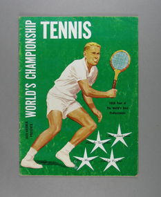 Tennis Australia
Magazine, 1959
Souvenir magazine: JACK KRAMER PRESENTS WORLD'S PROFESSIONAL CHAMPIONSHIP TENNIS 1959. Materials: Paper, Inktennis