Showing 1130 items
matching the day's work
-
 Kew Historical Society Inc
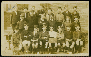
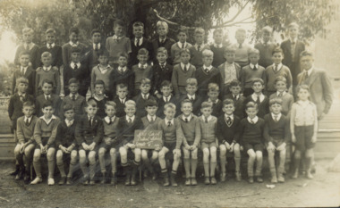
Photograph - Kew East State School, 1926
State School No. 3161 was originally situated between High Street (then Bulleen Road) and Kilby Road adjacent to Burke Road and was officially opened on 25th April 1892 with Mr Roland Gray as its Headmaster. With more people moving into the district, the School was moved in 1905 to Strathalbyn Street. (This site was to became the Kew East Bowling Club, and is now a Kindergarten.) 1929 saw the erection of the brick Infant School adjacent to the main building. In subsequent years many other buildings were added, including a weatherboard ‘Rural’ school, a brick library, an administration block, several portables, and a Community Music Centre and shelter sheds, culminating in the opening in March 2011 of the Commonwealth funded new Music/Sports Complex. At one time it was called Kew East Central School and included years 7 & 8. When Kew High School started, the high school students were accommodated there whilst their buildings were being completed.Original print positive of class of boys at Kew East State School. Hector Canham is identified in an inscription on the reverse of the mount. The Age newspaper on 6 March 1906 included in News of the Day that: "At a meeting of the Executive Council yesterday it was decided to proclaim the following State schools as training schools under the provisions of the Teachers' Act: Brunswick 1213; Queensberry-street, Carlton 2365; Kew East 3161; and Queensberry-street, North Melbourne 307. These schools have been specially selected and staffed in order that teachers in training and junior teachers may study the methods of the best teachers in special kinds of work. The infant class is the special feature at Brunswick, while Kew East will be a model of the methods of a country school. The schools at Queensberry-street, North Carlton and North Melbourne, are to be more especially connected with the training college."Obverse : "Hector [arrowed]" / Reverse: "5th Grade. Hector Canham. Back row left."kew east primary school, elizabeth angel, kew east state school, hector canham -
 Kew Historical Society Inc
Photograph - Kew East State School
State School No. 3161 was originally situated between High Street (then Bulleen Road) and Kilby Road adjacent to Burke Road and was officially opened on 25th April 1892 with Mr Roland Gray as its Headmaster. With more people moving into the district, the School was moved in 1905 to Strathalbyn Street. (This site was to became the Kew East Bowling Club, and is now a Kindergarten.) 1929 saw the erection of the brick Infant School adjacent to the main building. In subsequent years many other buildings were added, including a weatherboard ‘Rural’ school, a brick library, an administration block, several portables, and a Community Music Centre and shelter sheds, culminating in the opening in March 2011 of the Commonwealth funded new Music/Sports Complex. At one time it was called Kew East Central School and included years 7 & 8. When Kew High School started, the high school students were accommodated there whilst their buildings were being completed.Original print positive of a co-educational class at Kew East State School. Margaret Nickell is identified in an inscription on the reverse of the mount. The Age newspaper on 6 March 1906 included in News of the Day that: "At a meeting of the Executive Council yesterday it was decided to proclaim the following State schools as training schools under the provisions of the Teachers' Act: Brunswick 1213; Queensberry-street, Carlton 2365; Kew East 3161; and Queensberry-street, North Melbourne 307. These schools have been specially selected and staffed in order that teachers in training and junior teachers may study the methods of the best teachers in special kinds of work. The infant class is the special feature at Brunswick, while Kew East will be a model of the methods of a country school. The schools at Queensberry-street, North Carlton and North Melbourne, are to be more especially connected with the training college."Obverse : "Margery [arrowed]" / Reverse: "Margery Nickell. 2nd row left end. Teacher Miss Grey."kew east primary school, elizabeth angel, kew east state school, margery nickell -
 Kew Historical Society Inc
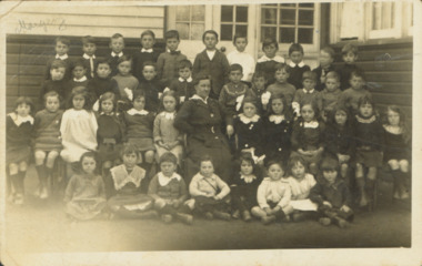
Photograph - Kew East State School, 1921-28
State School No. 3161 was originally situated between High Street (then Bulleen Road) and Kilby Road adjacent to Burke Road and was officially opened on 25th April 1892 with Mr Roland Gray as its Headmaster. With more people moving into the district, the School was moved in 1905 to Strathalbyn Street. (This site was to became the Kew East Bowling Club, and is now a Kindergarten.) 1929 saw the erection of the brick Infant School adjacent to the main building. In subsequent years many other buildings were added, including a weatherboard ‘Rural’ school, a brick library, an administration block, several portables, and a Community Music Centre and shelter sheds, culminating in the opening in March 2011 of the Commonwealth funded new Music/Sports Complex. At one time it was called Kew East Central School and included years 7 & 8. When Kew High School started, the high school students were accommodated there whilst their buildings were being completed.Original print positive of a class of girls at Kew East State School. The Age newspaper on 6 March 1906 included in News of the Day that: "At a meeting of the Executive Council yesterday it was decided to proclaim the following State schools as training schools under the provisions of the Teachers' Act: Brunswick 1213; Queensberry-street, Carlton 2365; Kew East 3161; and Queensberry-street, North Melbourne 307. These schools have been specially selected and staffed in order that teachers in training and junior teachers may study the methods of the best teachers in special kinds of work. The infant class is the special feature at Brunswick, while Kew East will be a model of the methods of a country school. The schools at Queensberry-street, North Carlton and North Melbourne, are to be more especially connected with the training college."Obverse : "East Kew 1921 [sic] / Reverse: "East Kew 1928 [sic]"kew east primary school, elizabeth angel, kew east state school -
 Kew Historical Society Inc
Photograph - Kew East State School
State School No. 3161 was originally situated between High Street (then Bulleen Road) and Kilby Road adjacent to Burke Road and was officially opened on 25th April 1892 with Mr Roland Gray as its Headmaster. With more people moving into the district, the School was moved in 1905 to Strathalbyn Street. (This site was to became the Kew East Bowling Club, and is now a Kindergarten.) 1929 saw the erection of the brick Infant School adjacent to the main building. In subsequent years many other buildings were added, including a weatherboard ‘Rural’ school, a brick library, an administration block, several portables, and a Community Music Centre and shelter sheds, culminating in the opening in March 2011 of the Commonwealth funded new Music/Sports Complex. At one time it was called Kew East Central School and included years 7 & 8. When Kew High School started, the high school students were accommodated there whilst their buildings were being completed.Original print positive of a class of girls at what is believed to be Kew East State School. The Age newspaper on 6 March 1906 included in News of the Day that: "At a meeting of the Executive Council yesterday it was decided to proclaim the following State schools as training schools under the provisions of the Teachers' Act: Brunswick 1213; Queensberry-street, Carlton 2365; Kew East 3161; and Queensberry-street, North Melbourne 307. These schools have been specially selected and staffed in order that teachers in training and junior teachers may study the methods of the best teachers in special kinds of work. The infant class is the special feature at Brunswick, while Kew East will be a model of the methods of a country school. The schools at Queensberry-street, North Carlton and North Melbourne, are to be more especially connected with the training college."Reverse : "Margery Nickell. 2nd row, 2nd left"kew east primary school, elizabeth angel, kew east state school, margery nickell -
 Kew Historical Society Inc
Photograph - Kew East Central School, c.1911
State School No. 3161 was originally situated between High Street (then Bulleen Road) and Kilby Road adjacent to Burke Road and was officially opened on 25th April 1892 with Mr Roland Gray as its Headmaster. With more people moving into the district, the School was moved in 1905 to Strathalbyn Street. (This site was to became the Kew East Bowling Club, and is now a Kindergarten.) 1929 saw the erection of the brick Infant School adjacent to the main building. In subsequent years many other buildings were added, including a weatherboard ‘Rural’ school, a brick library, an administration block, several portables, and a Community Music Centre and shelter sheds, culminating in the opening in March 2011 of the Commonwealth funded new Music/Sports Complex. At one time it was called Kew East Central School and included years 7 & 8. When Kew High School started, the high school students were accommodated there whilst their buildings were being completed.Original print positive of a class of boys at Kew East Central School. The Age newspaper on 6 March 1906 included in News of the Day that: "At a meeting of the Executive Council yesterday it was decided to proclaim the following State schools as training schools under the provisions of the Teachers' Act: Brunswick 1213; Queensberry-street, Carlton 2365; Kew East 3161; and Queensberry-street, North Melbourne 307. These schools have been specially selected and staffed in order that teachers in training and junior teachers may study the methods of the best teachers in special kinds of work. The infant class is the special feature at Brunswick, while Kew East will be a model of the methods of a country school. The schools at Queensberry-street, North Carlton and North Melbourne, are to be more especially connected with the training college."Obverse: on chalkboard - "East Kew Central School, Grade 5. 1911 [sic]". kew east primary school, elizabeth angel, kew east state school, kew east central school -
 Kew Historical Society Inc
Book, Rosalie Triolo, Our Schools and the War, 2012
"The Great War profoundly touched the lives of Australian teachers, school children and local communities, and with lasting consequences. Every teacher had the task of explaining the war to their students. Many teachers, a disproportionately large number, fought and died, and were joined by their older students. For years after, the names of those who fell were respectfully displayed on school honor boards, in honor books and remembered by other commemorative means, including through the introduction of Anzac Day. How teachers and school communities were affected by patriotic appeals and activities, and how they responded to the long years of grim news from Gallipoli, the Western Front and other sites of training, fighting and convalescence, is revealed in an account that historians, general readers and today's students will find illuminating and deeply moving." --Back cover.North Melbourne, Vic. : Australian Scholarly Publishing, 2012 : xvii, 364 pages : illustrations, facsimiles, portraits ; 25 cm non-fiction"The Great War profoundly touched the lives of Australian teachers, school children and local communities, and with lasting consequences. Every teacher had the task of explaining the war to their students. Many teachers, a disproportionately large number, fought and died, and were joined by their older students. For years after, the names of those who fell were respectfully displayed on school honor boards, in honor books and remembered by other commemorative means, including through the introduction of Anzac Day. How teachers and school communities were affected by patriotic appeals and activities, and how they responded to the long years of grim news from Gallipoli, the Western Front and other sites of training, fighting and convalescence, is revealed in an account that historians, general readers and today's students will find illuminating and deeply moving." --Back cover.ww1, first world war, schools, education, wwi -
 Kew Historical Society Inc
Journal, Kewriosity : September 1992
Opportunity for employers & unemployed young people / p1.Kew Festival and education / p1. Kew's Community Bus / p1. Chief Executive's Column [Influences on rates and charges for 1992/93]; City of Kew Streetscaping Committee / Malcolm Hutchinson p2. Mayor's Comment / Cr Roger Streeton p3. Diary Dates for September/October [1992] / p4. Municipal Health Plan have your say? / p5. Volunteer wanted [Kew Cottges] / p5. Work at home as a family day care giver / p5. Nutrition information win prizes / p6. Holiday fun for children & teenagers / p7. What do women at mid-life want? / p7. Be wise with medicines month / p7. 12 month trials of multi-dwelling development code / p7. Pictures of Kew [Mrs June Stratford, Head of Carey Junior School; Octagonal shelter, Boroondara Cemetery; St Anthony's Home for Children 1922-76; The Hartwell Players] / p8.Kewriosity was a local newsletter combining Kew Council and community news. It was published between November 1983 and June 1994, replacing an earlier Kewriosity [broad] Sheet (1979-84). In producing Kewriosity, Council aimed to provide a range of interesting and informative articles covering its deliberations and decision making, together with items of general interest and importance to the Kew community and information not generally available through daily media outlets.non-fictionOpportunity for employers & unemployed young people / p1.Kew Festival and education / p1. Kew's Community Bus / p1. Chief Executive's Column [Influences on rates and charges for 1992/93]; City of Kew Streetscaping Committee / Malcolm Hutchinson p2. Mayor's Comment / Cr Roger Streeton p3. Diary Dates for September/October [1992] / p4. Municipal Health Plan have your say? / p5. Volunteer wanted [Kew Cottges] / p5. Work at home as a family day care giver / p5. Nutrition information win prizes / p6. Holiday fun for children & teenagers / p7. What do women at mid-life want? / p7. Be wise with medicines month / p7. 12 month trials of multi-dwelling development code / p7. Pictures of Kew [Mrs June Stratford, Head of Carey Junior School; Octagonal shelter, Boroondara Cemetery; St Anthony's Home for Children 1922-76; The Hartwell Players] / p8. publications -- city of kew (vic.), kewriosity, council newsletters, community newsletters -
Kew Historical Society Inc
Journal, Kewriosity : July 1992
City of Kew Ward boundaries [map] / p1. Council election Saturday 1st August, 1992 Prospect Ward / p1. Letter from resident 'waste management' / Katrine Keuneman p2. Kew Junction Commercial Centre Precinct 8 / p2. Kew and Hawthorn a place for cyclists / p2. Mayor's Comment / Cr Daryl Oldaker p3. Come rain, hail or sunshine [school crossings] / p3 Kew Lioness Club / p3. Diary Dates for July/August pp.4-5. In Brief [Sold Kew Post Office; Help your postie deliver your mail; Carnsworth Nursing Home volunteers] / p4. In Brief continued [Kew Bowling Club; The Asthma Foundation of Victoria; Work at home as a family day caregiver; Kew Band; Kew Senior Citizens: Lions Club Opportunity Shop] / p5. My feelings on Kew / Chris Howlett p6. Youth homelessness / p6. Kew Festival / p6. Victorian Disabled Skiers' Assoc./ p7. Midwifery commemoration / p7. Vaccination against Haemophilus Influenzae Type B Disease / p7. Quit Quiz / p7. Our [Four Seasons] window [by Alan Sumner, in Kew Library] / p7. Pictures of Kew Kew High School students; Dedication of Burke Hall oval to past Mayor of Kew, the late Jack Gervasoni; Volunteers Reception; Bryan Berry] p8.Kewriosity was a local newsletter combining Kew Council and community news. It was published between November 1983 and June 1994, replacing an earlier Kewriosity [broad] Sheet (1979-84). In producing Kewriosity, Council aimed to provide a range of interesting and informative articles covering its deliberations and decision making, together with items of general interest and importance to the Kew community and information not generally available through daily media outlets.non-fictionCity of Kew Ward boundaries [map] / p1. Council election Saturday 1st August, 1992 Prospect Ward / p1. Letter from resident 'waste management' / Katrine Keuneman p2. Kew Junction Commercial Centre Precinct 8 / p2. Kew and Hawthorn a place for cyclists / p2. Mayor's Comment / Cr Daryl Oldaker p3. Come rain, hail or sunshine [school crossings] / p3 Kew Lioness Club / p3. Diary Dates for July/August pp.4-5. In Brief [Sold Kew Post Office; Help your postie deliver your mail; Carnsworth Nursing Home volunteers] / p4. In Brief continued [Kew Bowling Club; The Asthma Foundation of Victoria; Work at home as a family day caregiver; Kew Band; Kew Senior Citizens: Lions Club Opportunity Shop] / p5. My feelings on Kew / Chris Howlett p6. Youth homelessness / p6. Kew Festival / p6. Victorian Disabled Skiers' Assoc./ p7. Midwifery commemoration / p7. Vaccination against Haemophilus Influenzae Type B Disease / p7. Quit Quiz / p7. Our [Four Seasons] window [by Alan Sumner, in Kew Library] / p7. Pictures of Kew Kew High School students; Dedication of Burke Hall oval to past Mayor of Kew, the late Jack Gervasoni; Volunteers Reception; Bryan Berry] p8.publications -- city of kew (vic.), kewriosity, council newsletters, community newsletters -
Kew Historical Society Inc
Journal, Kewriosity : March 1986
Kew Festival looks bright! / p1. Dates for March / p2. [Community] Notices / p2&8. Update: Notes from Council - Commentary [Heritage] / Cr Phyllis Hore, Mayor of Kew p3. Traffic Management / p3. In Brief [The latest on restructure; Special Accommodation houses under review; New OT; Thank you; Numbers game; Heritage Study Grant; Kinder enrolments; Do you need a break from the kids?] / p4. Profile: Cr Wendy Smith / p4. Sheellah Mosley retires [Davis Street Kindergarten] / p5. A stone's throw from Kew [Fairfield] / p6. For history lovers [Local History Handbook] / p6. Kew/North Balwyn nursing mums / p6. The real Gladstone College [history] / p7. Kew Community House [Many hands make light work; It's 1st term at the Kew Community House; Photocopying for community groups; Open Day] / p7. Senior Citizens' Week: Program of events in Kew / p8.Kewriosity was a local newsletter combining Kew Council and community news. It was published between November 1983 and June 1994, replacing an earlier Kewriosity [broad] Sheet (1979-84). In producing Kewriosity, Council aimed to provide a range of interesting and informative articles covering its deliberations and decision making, together with items of general interest and importance to the Kew community and information not generally available through daily media outlets.non-fictionKew Festival looks bright! / p1. Dates for March / p2. [Community] Notices / p2&8. Update: Notes from Council - Commentary [Heritage] / Cr Phyllis Hore, Mayor of Kew p3. Traffic Management / p3. In Brief [The latest on restructure; Special Accommodation houses under review; New OT; Thank you; Numbers game; Heritage Study Grant; Kinder enrolments; Do you need a break from the kids?] / p4. Profile: Cr Wendy Smith / p4. Sheellah Mosley retires [Davis Street Kindergarten] / p5. A stone's throw from Kew [Fairfield] / p6. For history lovers [Local History Handbook] / p6. Kew/North Balwyn nursing mums / p6. The real Gladstone College [history] / p7. Kew Community House [Many hands make light work; It's 1st term at the Kew Community House; Photocopying for community groups; Open Day] / p7. Senior Citizens' Week: Program of events in Kew / p8. publications -- city of kew (vic.), kewriosity, council newsletters, community newsletters -
Kew Historical Society Inc
Journal, Kewriosity : November 1985
Our window [Alan Sumner, The Four Seasons] / p1. Linear Park will not affect E6 [Outer Circle railway reserve] / p1&5. Dates for November / p2&8. [Community] Notices / p2. Update: Notes from Council - [Council] Budget Go-ahead / Cr Phyllis Hore [Mayor of Kew] / p3. Traffic management / p3. In Brief [Recycling transfer; Walmer Street Appeal quashed; Deregulation of shared housing; Review sought on full day care decision; Whither Willsmere?; Cable tram centenary exhibition; Election possible; Community Assistance Grants] / p4. Death of Councillor Murray Wood / p4. 40 years of home-help in Kew / p5. Three year old Kinder [Argyle Road; Davis Street] / p5. Youth Page - New publications for youth [Streetwise comics; Making unemployment work] / p6. How we passed our time - 2 [social history] / Bill Stent p7. A Group Apprenticeship Scheme for Eastern Suburbs / p7. Kew Community House / p8. Room for one more [student hosting] / p8. North Kew Tennis Club / p8. Kew Young Liberals / p8. Kew Band in concert / p8.Kewriosity was a local newsletter combining Kew Council and community news. It was published between November 1983 and June 1994, replacing an earlier Kewriosity [broad] Sheet (1979-84). In producing Kewriosity, Council aimed to provide a range of interesting and informative articles covering its deliberations and decision making, together with items of general interest and importance to the Kew community and information not generally available through daily media outlets.non-fictionOur window [Alan Sumner, The Four Seasons] / p1. Linear Park will not affect E6 [Outer Circle railway reserve] / p1&5. Dates for November / p2&8. [Community] Notices / p2. Update: Notes from Council - [Council] Budget Go-ahead / Cr Phyllis Hore [Mayor of Kew] / p3. Traffic management / p3. In Brief [Recycling transfer; Walmer Street Appeal quashed; Deregulation of shared housing; Review sought on full day care decision; Whither Willsmere?; Cable tram centenary exhibition; Election possible; Community Assistance Grants] / p4. Death of Councillor Murray Wood / p4. 40 years of home-help in Kew / p5. Three year old Kinder [Argyle Road; Davis Street] / p5. Youth Page - New publications for youth [Streetwise comics; Making unemployment work] / p6. How we passed our time - 2 [social history] / Bill Stent p7. A Group Apprenticeship Scheme for Eastern Suburbs / p7. Kew Community House / p8. Room for one more [student hosting] / p8. North Kew Tennis Club / p8. Kew Young Liberals / p8. Kew Band in concert / p8. publications -- city of kew (vic.), kewriosity, council newsletters, community newsletters -
 Kew Historical Society Inc
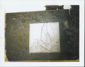
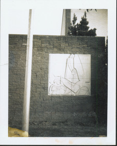
Photograph - Second World War Memorial, Kew Library, c.1960
George Henry Allen (8 February 1900 – 12 October 1972) was an Australian sculptor and teacher, an official war artist in the latter years of the Second World War. He served as an official war artist with the rank of lieutenant from December 1943, working at Port Moresby and the Australian War Memorial, retired February 1945. The plaque by George Allen on the exterior wall of the north side of Kew Library commemorating WW2 was funded by a bequest from the late Mrs Annie Anderson.One of two black and white snapshots (polaroid photos) of George Allen's sculpture at Kew Library. Mavis Rolley wrote about the memorial in 1980 as: This impressive piece of Sculpture, a memorial to the sacrifice of those who served in the Second World War, was completed in 1960 to coincide with the One Hundred Centenary Year of the City of Kew, and was unveiled on Anzac Day of that year by the Hon. A.G. Rylah, Chief Secretary, Deputy Premier of Victoria. Mr. George Allen, sculptor, submitted the winning design and through the contribution of a generous bequest of the late Mrs. Annie Anderson, a former resident of Kew, the Municipal Office was able to commission this gentleman’s work. The memorial is mounted on a wall of granite blocks and carved in Sydney Freestone, depicting a scene of war and loved ones at home.war memorials -- kew (vic.), memorials -- world war 2. -- kew (vic.), george henry allen, artworks -- kew library -
 Kew Historical Society Inc
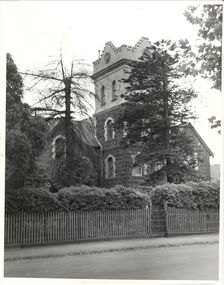
Photograph, J E & B L Rogers, 'Ivy Grange', Malmsbury Street, c. 1965
Rate Book evidence records that by 1870 Charles Vickers, architect, was the occupier of this house, having an NA.V. at that date o f£1105, although it is apparent that the house was in fact built by 1864, from the dat; set in the brickwork above the main door. In 1873 the property was purchased by David Beath, a merchant, and it was in the following year that the house was first recorded as 'Ivy Grange'. Beath was a deeply religious man and was a foundation member of both the Congregational and the Presbyterian (the Church of Scotland) Churches of Kew . He added, probably the tower wing, to the house in 1877 when architects Crouch and Wilson called tenders in that year 'for the erection of bluestone additions to (a) villa at Kew, for Davis Beath Esq.' The house was again added to in 1885 by the leading firm Reed, Henderson and Smart. For a number of years in the 1920s 'Ivy Grange' was used as a private mental hospital and is currently a guest house. In 1921 a fete was held at Ivy Grange in aid of building a new church (Sacred Heart, Kew): "Garden Fete in Aid of New Church, Kew. A SUCCESSFUL FUNCTION. Beautiful weather favoured the opening of a garden fete at "Ivy Grange," the residence of Mr. and Mrs. J. Lawlor, Malmsbury and Princess streets, Kew, on last Saturday afternoon, in aid of the fine new Church of the Sacred Heart, Kew, which is now receiving its finishing touches. Not content to wait for the official opening, the lady stallholders did a good business on the previous evening. The ceremony was performed" by the Very Rev. Dean Hegarty, P.P., V.F. (Carlton), with whom were associated the Rev. J. Manly, P.P. (Kew), and the Rev. R. S. Benson, P.P. (South Yarra), Mr. and Mrs. J. Lawlor, and others. Fr. Manly, who was cordially received, said he desired to thank Mr. and Mrs. Lawlor for lending their charming grounds, and for the trouble, time and expense they had given to preparing for the fete. He wished to thank Dean Hegarty for coming to open the fete. The Dean had been a dear and lifelong friend of the late Fr. O'Donoghoe, the beloved pastor of the Kew parish. Next June the Dean would celebrate the golden jubilee of his priesthood, so they could see that he was not a young man. (Laughter.) He hoped that the fete would be a great success, and that when his Grace the Archbishop —: (applause) — should open the new church, he (the speaker) would be able to present a satisfactory financial statement. (Applause.) Dean Hegarty, who was very cordially received, said it was a source of great pleasure to him to come to Kew, of which he entertained many pleasant recollections. The new church would have delighted the heart of their late beloved pastor, but it had pleased God to take him to a holler temple. His mantle had fallen on worthy shoulders, in the person of Fr. Manly—(applause)—who was carrying on the work of the parish well and vigorously. (Applause.) Some wondered how these great works were successfully accomplished. The prime factor in the wonderful progress of the Church— the work of the people, priests and nuns—was their deep, abiding Catholic faith. (Applause.) Kew was not by any means a large parish, yet look at the magnificent church that Fr. Manly was building on the hill! He said to his people, "Come, follow me, and we shall win through." (Applause.) It gave him great pleasure to declare the fete open, and he wished it the highest measure of success. (Prolonged applause.) Mr. J. Lawlor, who was greeted with applause, in moving a hearty vote of thanks to Dean Hegarty for his presence and support, said he knew of the great work done by the Dean in Gippsland, where he (the speaker) lived when a young man. The Dean ministered to a parish at that time as large as was the diocese of Sale to-day. The Dean and Fr. Manly reflected credit on the pioneer priests, who had laid well and solidly the foundations, of religion in Victoria. (Applause.) He was glad that reference had been~made to the work of their late beloved pastor, Fr. O'Donoghoe. : Mr. Pierce Cody seconded the motion, which, was carried by acclamation. The Dean,* in acknowledging the compliment, paid a tribute to Mr. and Mrs. Lawlor for their great generosity in connection with the fete, and complimented them on their successful efforts. (Applause.). A cafe chantant, organised by Mr. John. Sullivan, was contributed to by Misses G. Hornal, M. O'Donnell, Ella Burke, Eileen Burke, Alice Marsh, and M. Carrucan, and Messrs. T. Hammond, J. Donovan, J. Sullivan, and Fr. Lanigan. Mrs. J. Donovan was at the piano. St. Vincent de Paul Boys' Orphanage Band (South Melbourne) rendered selections. The stalls ware as follow:—Cake and Sweets Stall: Mesdames Needham, Treacey, Lynch and Cody. Fancy Stall: Mesdames Lawlor, J. P. Martin, M. Treacey, Simpson, Giddons and A. Molton, and Miss, Shirley. Refrestiment Stall: Mesdames Shiels, Hunter, Kealy, Duane and the Misses Turner and Delahunty; Produce Stall: Mesdames O'Sullivan, Mareli, Carrucan, and Kennedy. Mr. P. J. Kennedy acted as hon. general secretary. The fete was continued in the evening, the grounds being brilliantly illuminated. (Advocate (Melbourne, Vic. : 1868 - 1954), Thursday 7 April 1921, page 13) In 1930 it was acquired by the Carmelite Fathers for use as a novitiate: "IVY GRANGE," KEW." Acquired for Carmelite Novitiate. The valuable property, "Ivy Grange," Kew. which" belonged to the McGuiness family has been acquired by the Carmelite Fathers for a novitiate." (Advocate (Melbourne, Vic. : 1868 - 1954), Thursday 18 September 1930, page 18This work forms part of the collection assembled by the historian Dorothy Rogers, that was donated to the Kew Historical Society by her son John Rogers in 2015. The manuscripts, photographs, maps, and documents were sourced by her from both family and local collections or produced as references for her print publications. Many were directly used by Rogers in writing ‘Lovely Old Homes of Kew’ (1961) and 'A History of Kew' (1973), or the numerous articles on local history that she produced for suburban newspapers. Most of the photographs in the collection include detailed annotations in her hand. The Rogers Collection provides a comprehensive insight into the working habits of a historian in the 1960s and 1970s. Together it forms the largest privately-donated collection within the archives of the Kew Historical Society.Ivy Grange, cnr Malmsbury and Princess Streets, Kew. Ivy Grange. Home of David Beath. Commenced 1864, Tower Wing added 1877. Chap 38.ivy grange, malmsbury street, dorothy rogers, david beath, charles vickers, crouch and wilson, kew houses -
 Kew Historical Society Inc
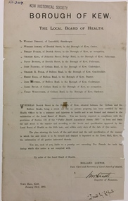
Document, Holland Loxton, Notification to the Residents of Derrick Street by the Local Board of Health, 1885, 1885
Streets and drains were the basic infrastructure problems for Kew in the 1880s. Decent streets and drains were fundamental to the quality of life of the residents. Without drainage, streets became muddy, boggy and sometimes impassable. Pools and puddles of stagnant water became smelly. The run off water, mixed with human and animal wastes, because there was no sewerage, became a health hazard. Streets and drains then became what were known as 'a nuisance'. Kew suffered from bouts of typhoid fever during the 1880s. Derrick Street was a private street on the margin of the business district of Kew and a well-used thoroughfare. We hear first about Derrick Street when the ratepayers applied to Council to have the street 'taken over' in January 1881. The Council agreed, after much debate, but ratepayers had to pay half the costs. The argument of the majority of the Council was that there was an established policy that ratepayers of private streets either had to hand over the street fully-formed or pay half the costs if Council did the work. It was felt that to make an exception for Derrick Street would create a precedent for ratepayers of other private streets. On the other hand the ratepayers, and a minority of Council, believed that there were extenuating circumstances in the case of Derrick Street. They believed that the costing by the Borough Surveyor was excessive. They felt the Council was partly responsible for the state of the street due to a channel on Bulleen Road, which deposited sand in the street. The Council had also put in some kerbing at the entrance to the street. Finally, the ratepayers believed that the street had become an important and convenient thoroughfare in Kew, and thus should be an exception to the policy on private streets. In the end a decision was delayed to allow the ratepayers to drain and form the street themselves. And there the matter stood till September 1882, when Miss Reilly complained about rubbish on a block of land in Derrick Street. So, in October 1882 the Council agreed to take over and form the street with the ratepayers paying half the costs. The ratepayers did not want to pay, so the argument continued in Council into 1883. There was a standoff for a further 18 months, until the problem could no longer be ignored. In October 1884 the Inspector of Nuisances and the Health Officer reported that Derrick Street was a health hazard as there was no drainage outlet for waste water. These reports changed the status of the problem of Derrick Street. It became an issue of public health, and thus the Council, acting as the Local Board of Health, had power to prepare plans and order the ratepayers to drain the street and pay all the costs, or let the Council do the work and charge ratepayers half the costs of the works. By April 1885, the time for ratepayers to complete the works themselves had expired, so the Council proceeded with the work and required ratepayers to pay for their share of the costs. All ratepayers had paid by the end of April except Mr Whiddycombe, who refused to pay. Mr Whiddycombe was warned to pay in October 1885. Legal action was taken against him in November. The Council lost the case on technical grounds. The Council, acting as the Local Board of Health, relaunched the legal action and won. The last we hear of Derrick Street is that seven day’s notice was given to Derrick Street ratepayers to pay for the drainage works in May 1887. We presume that Mr Whiddycombe paid. (Research: Andrew Frost)Rare and historic publication issued by the Board of Health in the Borough of Kew in 1885 to residents of Derrick street regarding the need for proper drainage for the purpose of improving public health.Printed formal notice sent by the Board of Health of the Borough of Kew to landowners in Derrick Street, Kew. The notice advised the owners that they were required to form and drain the street according to the levels and specifications approved by the Board. The letter was sent on January 23rd 1885, and signed by the Inspector of Nuisances.borough of kew -- greater melbourne (vic.), council notices -- public health, derrick street -- kew (vic.) -
 Kew Historical Society Inc
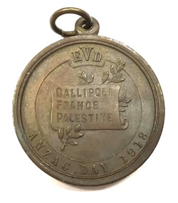
Medal, Education Department (Victoria), Anzac Day School Children's Medal, 1918
Anzac Day school children's medal, issued in 1918. The medal was distributed to every school child that year to commemorate Anzac Day. The Anzac forces first landed at Gallipoli on 25 April 1915. The medal sold to Victorian school children and the public to commemorate ANZAC Day, 25 April 1918. 250,000 medals were struck. Bronze medals were sold for 1 shilling and oxidised silver medals for 5 shillings. One-third of the proceeds was to be directed to the funding of a permanent institution for returned soldiers. [The Argus, 11 April 1918, p 8]This work forms part of the collection assembled by the historian Dorothy Rogers, that was donated to the Kew Historical Society by her son John Rogers in 2015. The manuscripts, photographs, maps, and documents were sourced by her from both family and local collections or produced as references for her print publications. Many were directly used by Rogers in writing ‘Lovely Old Homes of Kew’ (1961) and 'A History of Kew' (1973), or the numerous articles on local history that she produced for suburban newspapers. Most of the photographs in the collection include detailed annotations in her hand. The Rogers Collection provides a comprehensive insight into the working habits of a historian in the 1960s and 1970s. Together it forms the largest privately-donated collection within the archives of the Kew Historical Society.Bronze ANZAC Day medal distributed to all school children by the Department of Education in 1918 .Obverse has the bust of a uniformed soldier. The reverse image of the bust of an Australian soldier was adapted from a drawing by H. Harvey, an at assistant in the Victorian Education Department.Obverse: Bust of uniformed soldier wearing hat left; around, HONOR TO THE A.I.F. In small letters below bust, S&S 15C HH Reverse: Incuse on scroll which rests on olive branch, GALLIPOLI / FRANCE / PALESTINE; above EVD ; below, ANZAC DAY 1918anzac day medal (1918), commemorative medals, world war 1 - commemorations, australian commemorative medals -
 Kew Historical Society Inc
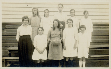
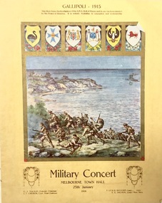
Programme - Concert Programme, Young Men's Christian Assn, Military Concert, Melbourne Town Hall, 25th January 1916, 1916
The Melbourne Argus on the following Day reported on the event: "MILITARY CONCERT. A sequel to the military sports gathering recently held on the Melbourne Cricket ground was provided last night at the Town Hall in the shape of a military concert, at which the prizes won at the sports were distributed. The proceeds of both fixtures will go to further the Y.M.C.A.'s work of providing winter comforts for troops on active service. Additional aid to the fund will be forthcoming from the sale of the handsome souvenir programmes the cover ol which is a replica of the A.N.A. roll of honour, and depicts the landing on Gallipoli. The charge made was an indefinite I one, with an irreducible minimum of six-pence." (Source: The Argus, 26 Jan 1916, p. 9)Military Concert, Melbourne Town Hall, 25th January 1916. 4 page program illustrated on the cover with an image of Australian troops landing at Gallipoli. Also included are the coats of arms of the Australian States at the time. The insert (Image 2016.0461a) includes details of the performances and performers. The best known of the performers at the concert was Horace Stevens.first world war (1914-18), gallipoli, military concerts -- melbourne -- 1914-1918 -
 Kew Historical Society Inc
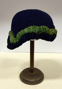
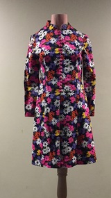
Headwear - Felt & Silk Velvet Cloche, 1920s
The Kew Historical Society’s fashion and design collection is comprised of costumes, hats, shoes and personal accessories. Many of these items were purchased or handmade in Victoria; some locally in Kew. The extensive hat collection comprises items dating from the 1860s to the 1970s. Most of the hats in the collection were created by milliners for women. There are however a number of early and important men’s hats in the collection. The headwear collection is particularly significant in that it includes the work of notable Australian and international milliners.The hat was owned and worn by Lilian Cohen.The McIntyre Collection of clothing and clothing accessories forms one of the largest single donations to our Fashion & Design collection. It includes clothing and clothing accessories worn by four women in the Cohen and McIntyre families across three generations. The items worn by Melbourne architect, and Kew resident, Dione McIntyre date from the 1960s and 1970s, and include evening wear, day wear, hats and shoes. As Dione McIntyre often accompanied her husband, fellow architect Peter McIntyre, to formal events, there are a number of pieces of evening wear among the items. The McIntyre Collection also includes items worn by women of an earlier generation: by Lilian Cohen, Dione McIntyre's mother, and by her mother-in-law, the wife of the architect Robert McIntyre. At the other end of the chronological spectrum are a number of outfits belonging to, worn and donated by Annie McIntyre. These include outfits created by notable late 20th century Australian and/or international fashion designers. The McIntyre Collection is significant historically and artistically as it includes examples of design that demonstrate changing tastes in fashion over an 80-year period. The collection is also significant in that it includes the work of a large number of Melbourne designers from the 1960s to the 1990s. 1920s navy blue felt cloche hat. The irregular border of the cloche is highlighted by a ruched band of emerald green velvet. The hat is part of the McIntyre Collection.Nilhats, australian fashion - millinery, fashion accessories, mcintyre collection, lilian cohen -
 Kew Historical Society Inc
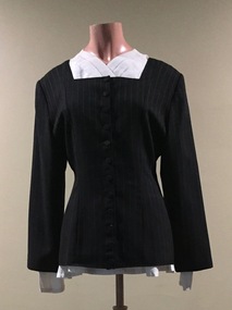
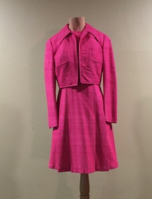
Clothing - Charcoal Grey Pinstripe Wool Jacket, Grey Skirt & White Blouse, Theodore & Scanlan, 1990s
The Fashion & Design collection of the Kew Historical Society includes examples of women’s, men’s, children’s and infants’ clothing from the 18th, 19th and 20th centuries. Items in the collection were largely produced for, or purchased by women in Melbourne, and includes examples of outerwear, protective wear, nightwear, underwear and costume accessories. This outfit is one of a number of items donated to the Fashion Collection by Annie McIntyre, who purchased the outfit in the later 1980s.The McIntyre Collection of clothing and clothing accessories forms one of the largest single donations to our Fashion & Design collection. It includes clothing and clothing accessories worn by four women in the Cohen and McIntyre families across three generations. The items worn by Melbourne architect, and Kew resident, Dione McIntyre date from the 1960s and 1970s, and include evening wear, day wear, hats and shoes. As Dione McIntyre often accompanied her husband, fellow architect Peter McIntyre, to formal events, there are a number of pieces of evening wear among the items. The McIntyre Collection also includes items worn by women of an earlier generation: by Lilian Cohen, Dione McIntyre's mother, and by her mother-in-law, the wife of the architect Robert McIntyre. At the other end of the chronological spectrum are a number of outfits belonging to, worn and donated by Annie McIntyre. These include outfits created by notable late 20th century Australian and/or international fashion designers. The McIntyre Collection is significant historically and artistically as it includes examples of design that demonstrate changing tastes in fashion over an 80-year period. The collection is also significant in that it includes the work of a large number of Melbourne designers from the 1960s to the 1990s. Black wool striped jacket with square neck and buttons in the same fabric at front. Other items in the outfit include a grey skirt and a white blouse. Gary Theodore and Fiona Scanlan started their fashion house in 1987.Label: Theodore and Scanlanfiona scanlan, women's clothing, australian fashion - 1980s, day wear, mcintyre collection, gary theodore -
 Kew Historical Society Inc
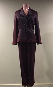
Clothing - Brown Satin Pants-suit, Scanlan Theodore, 1990s
The Fashion & Design collection of the Kew Historical Society includes examples of women’s, men’s, children’s and infants’ clothing from the 18th, 19th and 20th centuries. Items in the collection were largely produced for, or purchased by women in Melbourne, and includes examples of outerwear, protective wear, nightwear, underwear and costume accessories.The pantsuit was owned, worn and donated by Annie McIntyre.The McIntyre Collection of clothing and clothing accessories forms one of the largest single donations to our Fashion & Design collection. It includes clothing and clothing accessories worn by four women in the Cohen and McIntyre families across three generations. The items worn by Melbourne architect, and Kew resident, Dione McIntyre date from the 1960s and 1970s, and include evening wear, day wear, hats and shoes. As Dione McIntyre often accompanied her husband, fellow architect Peter McIntyre, to formal events, there are a number of pieces of evening wear among the items. The McIntyre Collection also includes items worn by women of an earlier generation: by Lilian Cohen, Dione McIntyre's mother, and by her mother-in-law, the wife of the architect Robert McIntyre. At the other end of the chronological spectrum are a number of outfits belonging to, worn and donated by Annie McIntyre. These include outfits created by notable late 20th century Australian and/or international fashion designers. The McIntyre Collection is significant historically and artistically as it includes examples of design that demonstrate changing tastes in fashion over an 80-year period. The collection is also significant in that it includes the work of a large number of Melbourne designers from the 1960s to the 1990s. Brown satin pantsuit comprising jacket and separate pants. The jacket has four buttons made of the same fabric. The matching pants of the same fabric and colour are tapered at the ankle.Label: Scanlan Theodorescanlan theodore, women's clothing, australian fashion - 1980s, day wear, pantsuits -
 Kew Historical Society Inc
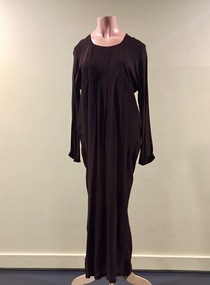
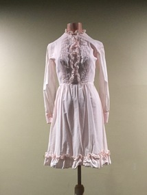
Clothing - Long Brown Crepe Evening Dress, Bow + Arrow, 1990s
The Fashion & Design collection of the Kew Historical Society includes examples of women’s, men’s, children’s and infants’ clothing from the 18th, 19th and 20th centuries. Items in the collection were largely produced for, or purchased by women in Melbourne, and includes examples of outerwear, protective wear, nightwear, underwear and costume accessories. This dress, made by Bow+Arrow, and donated by Annie McIntyre, is part of the McIntyre Collection.The McIntyre Collection of clothing and clothing accessories forms one of the largest single donations to our Fashion & Design collection. It includes clothing and clothing accessories worn by four women in the Cohen and McIntyre families across three generations. The items worn by Melbourne architect, and Kew resident, Dione McIntyre date from the 1960s and 1970s, and include evening wear, day wear, hats and shoes. As Dione McIntyre often accompanied her husband, fellow architect Peter McIntyre, to formal events, there are a number of pieces of evening wear among the items. The McIntyre Collection also includes items worn by women of an earlier generation: by Lilian Cohen, Dione McIntyre's mother, and by her mother-in-law, the wife of the architect Robert McIntyre. At the other end of the chronological spectrum are a number of outfits belonging to, worn and donated by Annie McIntyre. These include outfits created by notable late 20th century Australian and/or international fashion designers. The McIntyre Collection is significant historically and artistically as it includes examples of design that demonstrate changing tastes in fashion over an 80-year period. The collection is also significant in that it includes the work of a large number of Melbourne designers from the 1960s to the 1990s. Long sleeve brown crepe day dress with matching belt of a contrasting colour. The round necked dress has a high waist and soft pleated skirtLabel: BOW + ARROWbow + arrow, evening wear, evening dresses, australian fashion - 1970s, mcintyre collection, annie mcintyre -
 Kew Historical Society Inc
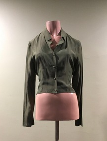
Clothing - Olive Green Silk Blouse, 1980s
The Fashion & Design collection of the Kew Historical Society includes examples of women’s, men’s, children’s and infants’ clothing from the 18th, 19th and 20th centuries. Items in the collection were largely produced for, or purchased by women in Melbourne, and includes examples of outerwear, protective wear, nightwear, underwear and costume accessories. This dress is one of a number of items donated to the Fashion Collection by Annie McIntyre.The McIntyre Collection of clothing and clothing accessories forms one of the largest single donations to our Fashion & Design collection. It includes clothing and clothing accessories worn by four women in the Cohen and McIntyre families across three generations. The items worn by Melbourne architect, and Kew resident, Dione McIntyre date from the 1960s and 1970s, and include evening wear, day wear, hats and shoes. As Dione McIntyre often accompanied her husband, fellow architect Peter McIntyre, to formal events, there are a number of pieces of evening wear among the items. The McIntyre Collection also includes items worn by women of an earlier generation: by Lilian Cohen, Dione McIntyre's mother, and by her mother-in-law, the wife of the architect Robert McIntyre. At the other end of the chronological spectrum are a number of outfits belonging to, worn and donated by Annie McIntyre. These include outfits created by notable late 20th century Australian and/or international fashion designers. The McIntyre Collection is significant historically and artistically as it includes examples of design that demonstrate changing tastes in fashion over an 80-year period. The collection is also significant in that it includes the work of a large number of Melbourne designers from the 1960s to the 1990s. Long sleeved olive green silk shirt buttoned at the front with buttons of the same fabric and colour. Label: Scanlan & Theodorescanlan & theodore, women's clothing, australian fashion - 1980s, mcintyre collection, day wear, blouses -
 Kew Historical Society Inc
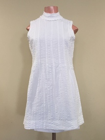
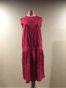
Clothing - White Cotton Summer Dress, Sportsgirl, 1960s
The Fashion & Design collection of the Kew Historical Society includes examples of women’s, men’s, children’s and infants’ clothing from the 18th, 19th and 20th centuries. Items in the collection were largely produced for, or purchased by women in Melbourne, and includes examples of outerwear, protective wear, nightwear, underwear and costume accessories. Sportsgirl is an Australian fashion house. Founded in 1948, the first Sportsgirl store was located in Swanston Street, Melbourne. During the 1950s the brand continued to expand its stores in Melbourne. It expanded to Sydney in the 1960s. The dress was donated by Dione McIntyre.The McIntyre Collection of clothing and clothing accessories forms one of the largest single donations to our Fashion & Design collection. It includes clothing and clothing accessories worn by four women in the Cohen and McIntyre families across three generations. The items worn by Melbourne architect, and Kew resident, Dione McIntyre date from the 1960s and 1970s, and include evening wear, day wear, hats and shoes. As Dione McIntyre often accompanied her husband, fellow architect Peter McIntyre, to formal events, there are a number of pieces of evening wear among the items. The McIntyre Collection also includes items worn by women of an earlier generation: by Lilian Cohen, Dione McIntyre's mother, and by her mother-in-law, the wife of the architect Robert McIntyre. At the other end of the chronological spectrum are a number of outfits belonging to, worn and donated by Annie McIntyre. These include outfits created by notable late 20th century Australian and/or international fashion designers. The McIntyre Collection is significant historically and artistically as it includes examples of design that demonstrate changing tastes in fashion over an 80-year period. The collection is also significant in that it includes the work of a large number of Melbourne designers from the 1960s to the 1990s. Sleeveless white cotton mini dress with a high round collarLabel: Sportsgirlwomen's clothing, fashion and textiles collection, australian fashion - 1960s, day dresses, mcintyre collection -
 Kew Historical Society Inc
Clothing - Evening Dress, Norma Tullo, c.1968
Norma Tullo began her dressmaking business in 1956. At the age of 20, she rented a small shop in the Metropole Arcade, initiating a career that included manufacturing, designing and retailing. In 1965, she became the first Australian to be selected by Butterick Company Inclusive to join their pattern making company. The stylish Tullo ‘look’ in the first half of the 1960s was young, colourful, feminine and most importantly had a strong American appeal. The patterns were distributed worldwide except to Russia and Germany. At this time, she had a collection of 300 garments. In the second half of the 1960s, she developed a new design range, influenced by the American 'hippie' style, featuring floor length dresses with long narrow sleeves, high round collars, and ruffles on the hems and at the cuffs. Patterns and colours became brighter to match prevailing tastes.The dress was owned, worn and donated to the collection by Dione McIntyre.The McIntyre Collection of clothing and clothing accessories forms one of the largest single donations to our Fashion & Design collection. It includes clothing and clothing accessories worn by four women in the Cohen and McIntyre families across three generations. The items worn by Melbourne architect, and Kew resident, Dione McIntyre date from the 1960s and 1970s, and include evening wear, day wear, hats and shoes. As Dione McIntyre often accompanied her husband, fellow architect Peter McIntyre, to formal events, there are a number of pieces of evening wear among the items. The McIntyre Collection also includes items worn by women of an earlier generation: by Lilian Cohen, Dione McIntyre's mother, and by her mother-in-law, the wife of the architect Robert McIntyre. At the other end of the chronological spectrum are a number of outfits belonging to, worn and donated by Annie McIntyre. These include outfits created by notable late 20th century Australian and/or international fashion designers. The McIntyre Collection is significant historically and artistically as it includes examples of design that demonstrate changing tastes in fashion over an 80-year period. The collection is also significant in that it includes the work of a large number of Melbourne designers from the 1960s to the 1990s. Long sleeved black cotton dress the fabric of which includes a pattern of small beige and cream polka dots. The ends of the sleeves and the base of the dress include ruffled trims of the same fabric. Label: TULLOnorma tullo, australian fashion - 1960s, women's clothing, day wear, mcintyre collection -
 Kew Historical Society Inc
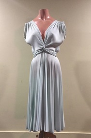
Clothing - Ice-Green Sun-Ray Pleated Dress, Prue Acton, 1963-1965
The Fashion & Design collection of the Kew Historical Society includes examples of women’s, men’s, children’s and infants’ clothing from the 18th, 19th and 20th centuries. Items in the collection were largely produced for, or purchased by women in Melbourne, and includes examples of outerwear, protective wear, nightwear, underwear and costume accessories.The outfit was owned, worn and donated to the collection by Dione McIntyre.The McIntyre Collection of clothing and clothing accessories forms one of the largest single donations to our Fashion & Design collection. It includes clothing and clothing accessories worn by four women in the Cohen and McIntyre families across three generations. The items worn by Melbourne architect, and Kew resident, Dione McIntyre date from the 1960s and 1970s, and include evening wear, day wear, hats and shoes. As Dione McIntyre often accompanied her husband, fellow architect Peter McIntyre, to formal events, there are a number of pieces of evening wear among the items. The McIntyre Collection also includes items worn by women of an earlier generation: by Lilian Cohen, Dione McIntyre's mother, and by her mother-in-law, the wife of the architect Robert McIntyre. At the other end of the chronological spectrum are a number of outfits belonging to, worn and donated by Annie McIntyre. These include outfits created by notable late 20th century Australian and/or international fashion designers. The McIntyre Collection is significant historically and artistically as it includes examples of design that demonstrate changing tastes in fashion over an 80-year period. The collection is also significant in that it includes the work of a large number of Melbourne designers from the 1960s to the 1990s. Elegant ice green coloured sunray pleated sleeveless dress. The dress comes from the earliest period of Prue Acton's design career [1963-91].Label: Prue Actonaustralian fashion - 1960s, women's clothing, day wear, mcintyre collection -
 Kew Historical Society Inc
Clothing - Pink Raw Silk Skirt and Jacket, L'Officiel, 1960s
The Fashion & Design collection of the Kew Historical Society includes examples of women’s, men’s, children’s and infants’ clothing from the 18th, 19th and 20th centuries. Items in the collection were largely produced for, or purchased by women in Melbourne, and includes examples of outerwear, protective wear, nightwear, underwear and costume accessories. This dress is one of a number of items donated to the Fashion collection by Dione McIntyre.The McIntyre Collection of clothing and clothing accessories forms one of the largest single donations to our Fashion & Design collection. It includes clothing and clothing accessories worn by four women in the Cohen and McIntyre families across three generations. The items worn by Melbourne architect, and Kew resident, Dione McIntyre date from the 1960s and 1970s, and include evening wear, day wear, hats and shoes. As Dione McIntyre often accompanied her husband, fellow architect Peter McIntyre, to formal events, there are a number of pieces of evening wear among the items. The McIntyre Collection also includes items worn by women of an earlier generation: by Lilian Cohen, Dione McIntyre's mother, and by her mother-in-law, the wife of the architect Robert McIntyre. At the other end of the chronological spectrum are a number of outfits belonging to, worn and donated by Annie McIntyre. These include outfits created by notable late 20th century Australian and/or international fashion designers. The McIntyre Collection is significant historically and artistically as it includes examples of design that demonstrate changing tastes in fashion over an 80-year period. The collection is also significant in that it includes the work of a large number of Melbourne designers from the 1960s to the 1990s.Hot pink coloured raw silk dress with matching jacket of the same colour and fabric. The skirt of the dress is constructed of broad pleats.Label: L'Officiell'officiel, mcintyre collection, day wear, australian fashion - 1960s, women's clothing -
 Kew Historical Society Inc
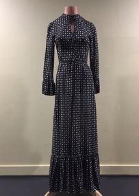
Clothing - Floral Dress, Kenneth Pirrie, 1960s
The Fashion & Design collection of the Kew Historical Society includes examples of women’s, men’s, children’s and infants’ clothing from the 18th, 19th and 20th centuries. Items in the collection were largely produced for, or purchased by women in Melbourne, and includes examples of outerwear, protective wear, nightwear, underwear and costume accessories. The outfit was owned, worn and donated to the collection by Dione McIntyre.The McIntyre Collection of clothing and clothing accessories forms one of the largest single donations to our Fashion & Design collection. It includes clothing and clothing accessories worn by four women in the Cohen and McIntyre families across three generations. The items worn by Melbourne architect, and Kew resident, Dione McIntyre date from the 1960s and 1970s, and include evening wear, day wear, hats and shoes. As Dione McIntyre often accompanied her husband, fellow architect Peter McIntyre, to formal events, there are a number of pieces of evening wear among the items. The McIntyre Collection also includes items worn by women of an earlier generation: by Lilian Cohen, Dione McIntyre's mother, and by her mother-in-law, the wife of the architect Robert McIntyre. At the other end of the chronological spectrum are a number of outfits belonging to, worn and donated by Annie McIntyre. These include outfits created by notable late 20th century Australian and/or international fashion designers. The McIntyre Collection is significant historically and artistically as it includes examples of design that demonstrate changing tastes in fashion over an 80-year period. The collection is also significant in that it includes the work of a large number of Melbourne designers from the 1960s to the 1990s.Brightly coloured, long sleeve floral cotton coat dress which has regular pink plastic buttons to waist.Label: Kenneth Pirriekenneth pirrie, women's clothing, australian fashion - 1970s, mcintyre collection, day wear, coat dresses -
 Kew Historical Society Inc
Clothing - Pink Cotton Dress, Norma Tullo, c.1965
Norma Tullo began her dressmaking business in 1956. At the age of 20, she rented a small shop in the Metropole Arcade, initiating a career that included manufacturing, designing and retailing. In 1965, she became the first Australian to be selected by Butterick Company Inclusive to join their pattern making company. The stylish Tullo ‘look’ in the first half of the 1960s was young, colourful, feminine and most importantly had a strong American appeal. The patterns were distributed worldwide except to Russia and Germany. At this time, she had a collection of 300 garments. This dress is one of a number of items donated to the Fashion Collection by Dione McIntyre.The McIntyre Collection of clothing and clothing accessories forms one of the largest single donations to our Fashion & Design collection. It includes clothing and clothing accessories worn by four women in the Cohen and McIntyre families across three generations. The items worn by Melbourne architect, and Kew resident, Dione McIntyre date from the 1960s and 1970s, and include evening wear, day wear, hats and shoes. As Dione McIntyre often accompanied her husband, fellow architect Peter McIntyre, to formal events, there are a number of pieces of evening wear among the items. The McIntyre Collection also includes items worn by women of an earlier generation: by Lilian Cohen, Dione McIntyre's mother, and by her mother-in-law, the wife of the architect Robert McIntyre. At the other end of the chronological spectrum are a number of outfits belonging to, worn and donated by Annie McIntyre. These include outfits created by notable late 20th century Australian and/or international fashion designers. The McIntyre Collection is significant historically and artistically as it includes examples of design that demonstrate changing tastes in fashion over an 80-year period. The collection is also significant in that it includes the work of a large number of Melbourne designers from the 1960s to the 1990s. Long sleeved, pale pink cotton mini dress designed by Norma Tullo with ruffled trims on the bodice and the hem of the skirtLabel: TULLOnorma tullo, australian fashion - 1960s, mcintyre collection, mini-dresses, day dresses -
 Kew Historical Society Inc
Clothing - Green Cotton Summer Dress with Pink Tulip Pattern, Allen Gaye, 1970s
The Fashion & Design collection of the Kew Historical Society includes examples of women’s, men’s, children’s and infants’ clothing from the 18th, 19th and 20th centuries. Items in the collection were largely produced for, or purchased by women in Melbourne, and includes examples of outerwear, protective wear, nightwear, underwear and costume accessories. This dress is one of a number of items donated to the Fashion Collection by Dione McIntyre.The McIntyre Collection of clothing and clothing accessories forms one of the largest single donations to our Fashion & Design collection. It includes clothing and clothing accessories worn by four women in the Cohen and McIntyre families across three generations. The items worn by Melbourne architect, and Kew resident, Dione McIntyre date from the 1960s and 1970s, and include evening wear, day wear, hats and shoes. As Dione McIntyre often accompanied her husband, fellow architect Peter McIntyre, to formal events, there are a number of pieces of evening wear among the items. The McIntyre Collection also includes items worn by women of an earlier generation: by Lilian Cohen, Dione McIntyre's mother, and by her mother-in-law, the wife of the architect Robert McIntyre. At the other end of the chronological spectrum are a number of outfits belonging to, worn and donated by Annie McIntyre. These include outfits created by notable late 20th century Australian and/or international fashion designers. The McIntyre Collection is significant historically and artistically as it includes examples of design that demonstrate changing tastes in fashion over an 80-year period. The collection is also significant in that it includes the work of a large number of Melbourne designers from the 1960s to the 1990s. Long dark green sun dress with a pink tulip pattern.Label: Allen Gayeallen gaye, women's clothing, australian fashion - 1970s, mcintyre collection, day wear -
 Kew Historical Society Inc
Clothing - Indian Cotton Dress, 1980s
The Fashion & Design collection of the Kew Historical Society includes examples of women’s, men’s, children’s and infants’ clothing from the 18th, 19th and 20th centuries. Items in the collection were largely produced for, or purchased by women in Melbourne, and includes examples of outerwear, protective wear, nightwear, underwear and costume accessories. This item was owned and worn by Dione McIntyre.The McIntyre Collection of clothing and clothing accessories forms one of the largest single donations to our Fashion & Design collection. It includes clothing and clothing accessories worn by four women in the Cohen and McIntyre families across three generations. The items worn by Melbourne architect, and Kew resident, Dione McIntyre date from the 1960s and 1970s, and include evening wear, day wear, hats and shoes. As Dione McIntyre often accompanied her husband, fellow architect Peter McIntyre, to formal events, there are a number of pieces of evening wear among the items. The McIntyre Collection also includes items worn by women of an earlier generation: by Lilian Cohen, Dione McIntyre's mother, and by her mother-in-law, the wife of the architect Robert McIntyre. At the other end of the chronological spectrum are a number of outfits belonging to, worn and donated by Annie McIntyre. These include outfits created by notable late 20th century Australian and/or international fashion designers. The McIntyre Collection is significant historically and artistically as it includes examples of design that demonstrate changing tastes in fashion over an 80-year period. The collection is also significant in that it includes the work of a large number of Melbourne designers from the 1960s to the 1980s. 1920s style red coloured dress of Indian cotton, tucked, and embroidered with beading.mcintyre collection, australian fashion - 1980s, women's clothing, day wear, dione mcintyre -
 Kew Historical Society Inc
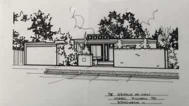
Drawing - Property Illustration, Margaret Picken, 75 Walpole Street, Kew, 1990
After training as a Cartographic Draftsman within the mining industry, I worked as a property illustrator for real estate firms in the eastern suburbs of Melbourne for 22 years from 1983. I initially photographed houses with a Polaroid camera and made a 'thumbnail' sketch while there. The photos were used to scale off a sketch in pencil and then that sketch was overlaid with drafting film and the 'pen and ink' completed. The pens I used were the Rotring ‘Rapidigraph’ drafting pens. The ink was also made by Rotring (German).The film was ‘Rapidraw’, polyester drafting film, double matte. It takes a very fine line and doesn’t bleed. As well as house sketches, there were often floor plans and site plans ordered. Aerial sketches were ordered when the property needed an overall view. (Margaret Picken, 2020)The Ernest House (former) at 75 Walpole Street was designed by Harry Ernest in 1955/56. It is one of ten Victorian dwellings in Neil Clerehan’s important 1961 book Best Australian Houses, which illustrated cutting-edge residential design of the day. The house is also significant as Harry Ernest’s first residential commission, introducing elements that characterised his subsequent output.This drawing of the house is one of a series created by Margaret Picken for a number of real estate agents in Melbourne between 1983 and 2006. Each work is signed and dated by the artist.Gift of Margaret Picken, 2020Pen and ink architectural drawing on drafting film of 75 Walpole Street, Kew by Margaret Picken.75 WALPOLE ST., KEW / MARGARET PICKEN '90 / WOODARDS ~artist -- margaret picken 1950-, architectural drawings -- houses -- kew (vic.), 75 walpole street -- kew (vic.)