Showing 10952 items matching "lander"
-
 Ringwood and District Historical Society
Flyer, Land Sale Advertisement - State School Estate, Ringwood, Victoria - 1923
The date of the flyer as circa 1920 can be estimated from the references to the (decision on) "electrification of the Croydon Railway Line" which eventually occurred in 1923, letting of tenders for the state school building which opened in 1924, and the "proposed new railway station" (East Ringwood) which opened in 1925, Advertisement for State School Estate, Ringwood - 26 residential allotments for sale near East Ringwood State School development site and 7 minutes walk from proposed new railway station (East Ringwood). Includes location map and terms of sale.Locality plan includes King Street and Government Roads (Later Everard Road, Holland Road, Purser Avenue, and Charles Street). (Agents) J.B. McAlpin, Estate Agent and Subdivisional Manager, Ringwood (Opposite Station), and F.V. Parker, Estate Agent, Main Street, Ringwood. -
 Ringwood and District Historical Society
Flyer, Land Sale Advertisement - Roebury Estate, Ringwood, Victoria - circa 1938
Advertisement for sale of residential allotments with map showing location and layout of subdivision, terms of sale, and summary of local features and services.Subdivision includes Dublin Road, Alexander Road, and Ferntree Gully Road (later Bedford Road). Agent - J.B. McAlpin, Opposite Railway Station, Ringwood. -
 Ringwood and District Historical Society
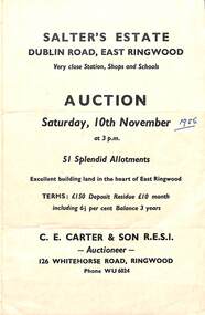
Flyer, Land Sale Auction Brochure, Salter's Estate, East Ringwood, Vic. - 1956
Folded single page advertising auction of allotments on Saturday, 10th November (1956), including layout of subdivision and terms of sale.Subdivision includes Railway Avenue, Nicholson Street, Althol Grove (later Morcom Avenue), Illoura Avenue, Tweed Street, Merry Street, and Dublin Road. (Agent) C.E. Carter & Son R.E.S.I., Auctioneer, 126 Whitehorse Road, Ringwood, Phone WU6024. -
 Ringwood and District Historical Society
Flyer, Land Sale Advertisement - Sunbeam Estate, East Ringwood, Victoria - circa 1930
Folded double-sided page advertising private sale of 48 residential allotments, with location map, terms of sale, and details of local features and services. Locality plan includes Holland Road, Everard Road, Sunbeam Avenue, Mount Dandenong Road, and Lilydale Road (later Old Lilydale Road). (Agents) Phillips & Nicholson, 59 Swanston Street, Melbourne, (Phone) Central 10907, in conjunction with C.E. Carter, Bank Chambers, Main Street, Ringwood, Telephone Ringwood 24. -
 Ringwood and District Historical Society
Flyer, Land Sale Advertisement and auction notice - Range View Estate, Ringwood, Victoria - 1920
Advertisement for sale of 150 residential allotments with terms of sale, summary of local features and services, and map showing location and layout of subdivision within the boundary of Mitcham to the west of Ringwood, Victoria. Copy of newspaper advertisement (The Herald, Melbourne, Wednesday 3 March, 1920) refers to public auction date for Range View Estate Ringwood - Saturday, 27th March, 1920.Subdivision includes Deep Creek Road, Range View Grove, Warnes Road, Tarrangower Avenue, Prince Edward Avenue, James Avenue, and White Horse Road, Mitcham. Agents - Phillips & Nicholson, 281 Collins Street, Melbourne, Telephone Central 10907. -
 Ringwood and District Historical Society
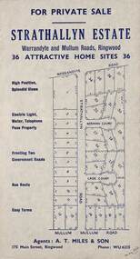
Flyer, Land Sale Advertisement - Strathallyn Estate, Ringwood, Victoria - circa 1950
Advertisement for private sale of 36 home sites in the Warrandyte Road and Mullum Mullum Road area of Ringwood, with map showing layout of subdivision and summary of local features and services. Handwritten notation indicates May, 1950.Subdivision includes Warrandyte Road, Strathallyn Road, Norman Court, Lade Court, and Mullum Mullum Road. Agents: A.T. Miles & Son, 175 Main Street, Ringwood, Phone WU6215. -
 Ringwood and District Historical Society
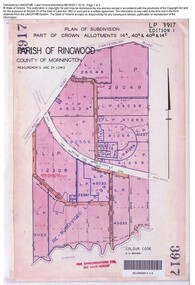
Document, Sale of Land Act documents - Part of Crown Allotments 14A, 40A, 40B & 4C, Parish of Ringwood - 1895
Certificate of Title - Georgina Elizabeth Wingfield Knox, wife of William Robert Knox, part of allotments 14A and 40A, 27th November, 1895, and subsequent transfers up to 1959. Plan of Subdivision includes Allens Road, The Greenway, Dickasons Road, and Canterbury Road, Ringwood. (With further residential and commercial developments taking place since the 1920s, this area became part of the suburb of Heathmont.) -
 Ringwood and District Historical Society
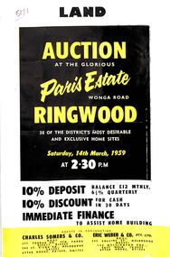
Flyer, Land Auction Advertisement, Paris Estate, Ringwood, Vic. - 1959
Double sided single page black and yellow printed advertisement for auction of home sites at Paris Estate, Wonga Road, Ringwood, Vic., on Saturday, 14th March, 1959, with terms of sale, locality map, subdivision features and summary of local services.Subdivision includes Mullum Mullum Road, Hendra Grove, Sunhill Road, and Wonga Road. Agents in conjunction: Charles Somers & Co., South Yarra and Melbourne, and Eric Weber & Co., Melbourne and East Melbourne. -
 Ringwood and District Historical Society
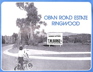
Flyer, Land Sale Advertisement, Oban Road Estate, Ringwood, Vic. - 1974
Double-sided folded page with blue border advertising sale of Oban Road Estate Ringwood building allotments. Front page features photograph of view from the estate towards Dandenong Ranges. Centrefold pages include terms of sale, layout and features of the subdivision, and summary of local services. Photocopy of typewritten price list for the 52 lots also attached.Subdivision includes Oban Road, Ambrie Avenue, Hendra Grove, and Mullum Mullum Road. (Agent) T.M. Burke Pty Ltd., 63 Exhibition Street Melbourne, Telephone 654 4144. -
 Ringwood and District Historical Society
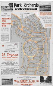
Map, Park Orchards Land Sale Advertisement, Doncaster, Victoria, Circa 1926
Large linen backed map of the Park Orchards subdivision for private sale of residential sites and recreation club, highlighting local facilities, services and layout of the estate. Surveyors - Tuxen & Miller, 34 Queen Street, Melbourne. Agents - Wm Addey & Co., Pty Ltd., National Mutual Buildings, 395 Collins Street, Melbourne, Phone F3906. Terms £5 deposit balance monthly installments of £1 with the residue at the end of five years. Subdivision includes Alva Avenue, Arundel Road, Aviemore Avenue, Berringa Road, Bowmore Avenue, Brucedale Crescent, Brympton Avenue, Camber Avenue, Cawdor Avenue, Colin Avenue, Corriedale Crescent, Craithie Avenue, Daintree Avenue, Dalry Avenue, Dirlton Crescent, Drayton Crescent, Elgin Crescent, Enfield Avenue, Ennismore Crescent, Euston Avenue, Feversham Avenue, Frogmore Crescent, Gosford Crescent, Granard Avenue, Hopetoun Road, Hylton Avenue (later Knees Road), Jura Avenue, Park Road. -
 Ringwood and District Historical Society
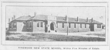
Photograph, Ringwood State School, Land sale brochure image - November, 1923
The same photo 2094b also appear in the Real Estate and Home Journal 15 January 1925 P17. -
 Ringwood and District Historical Society
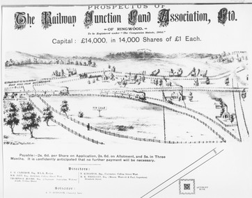
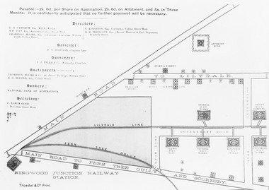
Photograph, Land sale prospectus - Railway Junction Land Association Ltd., Ringwood - circa 1890
Catalogue card reads, 'Early Sketch of Ringwood Layout (part). Not to scale but largely true to life of approximately 1890. Many local landmarks shown e.g. Wesleyan Chapel, Duncans Antimony Mine Hotel, Cass's School, Herry's Store. Maroondah Highway not shown but would approximate a line drawn from just to left of horse and cart near Chapel - North to pass around Antimony Mine and to the left to pass behind Cass's School.' -
 Ringwood and District Historical Society
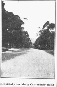
Photograph, Image used for land sale promotion of Coleman's Heathmont Estate, looking east along Canterbury Road, Heathmont, towards Bedford Road. Sale 15/12/1923 by Public Auction
Written on back of photograph, "Coleman's Heathmont Estate, looking towards Bedford Rd. Sale 15/12/1923 by Public Auction". -
 Ringwood and District Historical Society
Photograph, Image used for land sale promotion of Pratt's Junction Estate opposite Mount Dandenong Road, Ringwood - 24/11/1923
Catalogue card reads, "Pratt's Junction Estate - 24/11/1923, 86 lots". -
 Ringwood and District Historical Society
Photograph, Image used for land sale promotion of Coleman's Heathmont Estate, looking east along Canterbury Road, Heathmont. Sale 15/12/1923 by Public Auction
Catalogue card reads, "Coleman's Heathmont Estate - 1923. Sale 15/12/1923." -
 Ringwood and District Historical Society
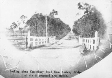
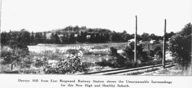
Photograph, Image used for land sale promotion of East Ringwood Railway Estate - 1925. Davey's Hill shown in the photograph later became the site of Maroondah Hospital adjoining Davey Drive, Ringwood East
Catalogue card reads, "Railway Estate 1925. Daveys Hill East Ringwood. Daveys Hill is now Maroondah Hospital ground." -
 Ringwood and District Historical Society
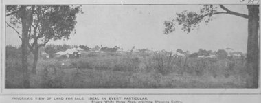
Photograph, Images used for land sale promotion of Coleman's Heathmont Estate, looking across the estate from Canterbury Road, Heathmont towards Bedford Road on the far boundary. Sale 15/12/1923 by Public Auction
Catalogue card reads, "Coleman's Heathmont Estate 1923. 15/12/1923. Looking across the estate from Canterbury Rd. Bedford Rd. is seen on the far boundary." -
 Ringwood and District Historical Society
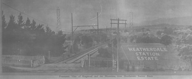
Photograph, View from where Heatherdale railway station is now situated, looking towards Ringwood - 2/2/1924. Land between Heatherdale Rd. and Madden St., sold 2nd Feb. 1924. J.B. McAlpin - agent"
Typed at bottom of photograph, "Panoramic view of Ringwood and the mountains, from Heatherdale Station Estate". Typed below photograph on mounting sheet, "View from where Heatherdale railway station is now looking towards Ringwood - 2/2/1924". "Between Heatherdale Rd. and Madden St., sold 2nd Feb. 1924. J.B. McAlpin - agent". -
 Ringwood and District Historical Society
Photograph, Land sale brochure map of Ringwood's early main central area around Mount Dandenong Road - c.1880s
Catalogue card reads, 'Map of Ringwood East'. -
 Orbost & District Historical Society
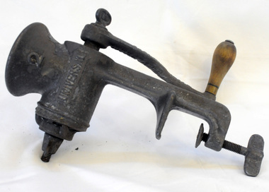
mincer, 1890's
This item was used by Helena Warren (nee McKeown), a well known photographer and local press correspondent. She lived at Newmerella. The meat mincer was a particularly popular kitchen gadget. By means of the mincer left overs and off cuts could be transformed into shepherd's pie or mince steak. Gadgets like this Universal food chopper are typical of domestic inventions designed to reinforce the principles of thrift and labour-saving. Many of these gadgets were imported from the United States. A cast iron metal hand mincer with a long metal body with an opening at one end, inside which is a circular spiral blade and a screw clamp attachment at the other end. On one side of the mincer is a curved metal handle held in place by a metal nut and a wooden bulb shaped knob at the end. There is a metal circular webbed blade held in place by a metal nut and bolt."Universal No. 2 brand; L.F. & C., New Britain, Conn., U.S.A."mincer chopper food-preparation -
 Orbost & District Historical Society
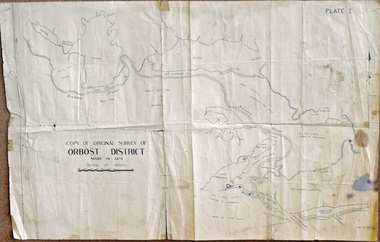
survey, 26th July 1950
This map is a research tool for identifying historical land records in Orbost.A copy of the original survey of Orbost District 1870. White background with black print. The original was hand-drawn in ink. This is PLATE 1.some pen marksmap survey-orbost -
 Fire Services Museum of Victoria
Fire Engine - Pump - Land Rover, Land Rover Fire Engine Pump - Dulux
-
 Flagstaff Hill Maritime Museum and Village
Equipment - Stretcher, 1965 to 1999
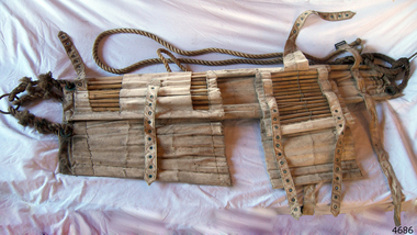
A Neil Robinson stretcher is a lightweight carrying device modelled on Japanese bamboo litters, the Neil Robertson rescue stretcher was developed in the early 1900s by John Neil Robertson. Used for lifting an injured person vertically. The stretcher is made from stout canvas reinforced with bamboo slats. The stretcher is designed for removing an injured person from spaces wherein access, doors or hatches are too small to permit the use of regular stretchers. Spaces such as ship engine room spaces, cargo holds, pump rooms, boiler rooms etc. are a few examples of such compact spaces.An item designed to transport injured personnel from tight places, either at sea or on land.A rescue stretcher made from white canvas reinforced with bamboo slats and adjustable canvas straps. The canvas straps are secured with metal buckles and there is a metal ring attached to lengths of ropes at both ends. Noneflagstaff hill, warrnambool, flagstaff hill maritime museum, maritime museum, shipwreck coast, flagstaff hill maritime village, great ocean road, stretcher, neil robertson, neil robertson rescue stretcher, rescue equipment -
 Flagstaff Hill Maritime Museum and Village
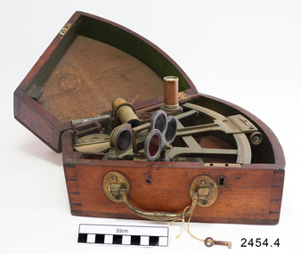
Octant, Mid to late 19th Century
An octant is an astronomical instrument used in measuring the angles of heavenly bodies such as the sun, moon and stars at sea in relation to the horizon. This measurement could then be used to calculate the altitude of the body measured, and then the latitude at sea could also be calculated. The angle of the arms of an octant is 45 degrees, or 1/8 of a circle, which gives the instrument its name. Two men independently developed the octant around 1730: John Hadley (1682–1744), an English mathematician, and Thomas Godfrey (1704–1749), a glazier in Philadelphia. While both have a legitimate and equal claim to the invention, Hadley generally gets the greater share of the credit. This reflects the central role that London and the Royal Society played in the history of scientific instruments in the eighteenth and nineteenth century's. There were also two others who are attributed to having created octanes during this period, Caleb Smith, an English insurance broker with a strong interest in astronomy (in 1734), and Jean-Paul Fouchy, a mathematics professor and astronomer in France (in 1732) In 1767 the first edition of the Nautical Almanac tabulated lunar distances, enabling navigators to find the current time from the angle between the sun and the moon. This angle is sometimes larger than 90°, and thus not possible to measure with an octant. For that reason, Admiral John Campbell, who conducted shipboard experiments with the lunar distance method, suggested a larger instrument and the sextant was developed. From that time onward, the sextant was the instrument that experienced significant development and improvements and was the instrument of choice for naval navigators. The octant continued to be produced well into the 19th century, though it was generally a less accurate and less expensive instrument. The lower price of the octant, including versions without a telescope, made it a practical instrument for ships in the merchant and fishing fleets. One common practice among navigators up to the late nineteenth century was to use both a sextant and an octant. The sextant was used with great care and only for lunar sightings while the octant was used for routine meridional altitude measurements of the sun every day. This protected the very accurate and pricier sextant while using the more affordable octant for general use where it performs well. The invention of the octant was a significant step in providing accuracy of a sailors latitude position at sea and his vessels distance from land when taking sightings of land-based landmarks.Octant with metal handle, three different colored shades are attached, in wooden wedge-shaped box lined with green felt. Key is attached. Two telescope eyepieces are in box. Some parts are missing. Oval ink stamp inside lid of box, scale is graduated to 45 degrees. Ink stamp inside lid of box "SHIPLOVERS SOCIETY OF VICTORIA. LIBRARY"instrument, flagstaff hill, warrnambool, shipwrecked coast, flagstaff hill maritime museum, maritime museum, shipwreck coast, flagstaff hill maritime village, great ocean road, octant, navigation, nautical instrument, navigation instrument, john hadley, sextant, astronomical instrument -
 Flagstaff Hill Maritime Museum and Village
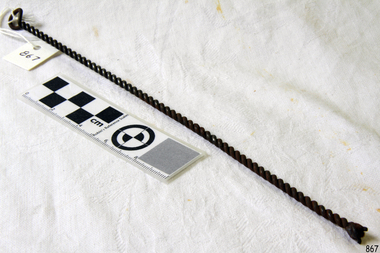
Tool - Stretching Hook
Hand forged metal tool, possibly a sailmaker's hook with the hook broken. It may be a fire iron. The twisted metal is a skill learned by a blacksmith.The item is a handmade tool, an example of the work of a blacksmith. Smiths were sought after in colonial Australia. Their trade allowed them to custom make work for the different industries necessary for survival in a new land.Sailmaker's stretching tool; long thin metal rod bent in half, with centre forming a handle or loop, and long ends twisted together to form a stem. The loose ends are formed together but appear broken.warrnambool, shipwreck coast, flagstaff hill, flagstaff hill maritime museum, flagstaff hill maritime village, tool, sailmaker's tool, fire iron, blacksmith, twisted rod, twisted wire, sailmaker's hook -
 Marysville & District Historical Society
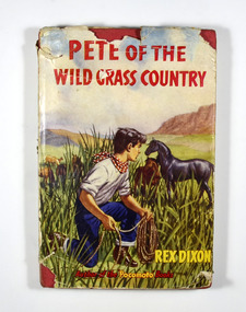
Book, Rex Dixon, Pete of the Wild Grass Country, 1954
Pete Cimarron, the wild boy, was raised by Indians in the Wild Grass Country of Texas. When the Indians moved on to new hunting grounds Pete was left to take care of himself. This he does by roaming over the Wild Grass Country catching wild horses, which he sells to his friend Murky Joe. When the wagon trains from the east begin to settle near the Wild Grass Country, Pete finds himself swept into an exciting struggle to claim and hold his land.Front dust cover shows a boy holding a rope lasso hiding behind tall grasses watching a black horse. There are other horses in the background. Also in the background is a grass plain which is ringed by mountains. The book itself is bound in red with the title in black writing. On the front of the book there is a logo of the Panther Library. The name of the author, the title and the publisher are written in black down the spine of the book.fictionPete Cimarron, the wild boy, was raised by Indians in the Wild Grass Country of Texas. When the Indians moved on to new hunting grounds Pete was left to take care of himself. This he does by roaming over the Wild Grass Country catching wild horses, which he sells to his friend Murky Joe. When the wagon trains from the east begin to settle near the Wild Grass Country, Pete finds himself swept into an exciting struggle to claim and hold his land.indians, texas, horses, rex dixon, panther library, fiction -
 Marysville & District Historical Society
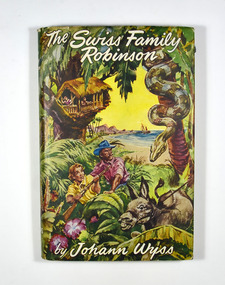
Book, The Swiss Family Robinson
The Swiss Family Robinson-father, mother and four young sons - are callously abandoned on a sinking ship near the rocky shore of an unknown land. the father, a man of unbounded energy and resourcefulness, makes a raft by means of which they ferry themselves and many useful goods to the shore. They establish a camp and are later able to salvage much of the cargo. Their first home, a tree-house, is later abandoned in favour of a cave which they convert into a permanent residence. their New Switzerland abounds in wild life and useful trees and plants, and they are able to lead a happy and diligent life farming, hunting, fishing and devising means of supplying all their household needs. Many years pass and the lads grow up strong and adventurous. At last the discovery of another castaway and the eventual arrival of a rescue ship set them the problem - to return to Europe or to remain in New Switzerland?Front cover has an illustration showing two people, one carrying a rifle, a donkey and a large boa constrictor. In the background is a tree-house and a bay of water with a small boat floating in the water. The back cover has a list of Hamly Classic books and the details of the publisher of the book.fictionThe Swiss Family Robinson-father, mother and four young sons - are callously abandoned on a sinking ship near the rocky shore of an unknown land. the father, a man of unbounded energy and resourcefulness, makes a raft by means of which they ferry themselves and many useful goods to the shore. They establish a camp and are later able to salvage much of the cargo. Their first home, a tree-house, is later abandoned in favour of a cave which they convert into a permanent residence. their New Switzerland abounds in wild life and useful trees and plants, and they are able to lead a happy and diligent life farming, hunting, fishing and devising means of supplying all their household needs. Many years pass and the lads grow up strong and adventurous. At last the discovery of another castaway and the eventual arrival of a rescue ship set them the problem - to return to Europe or to remain in New Switzerland?swiss family robinson, shipwreck, switzerland, johann r. wyss, fiction -
 Marysville & District Historical Society
Photograph (item) - Colour tinted photograph, Valentine Publishing Co. Pty. Ltd, The Road to Cumberland Valley, Marysville. No. 1, 1923-1963
An early colour tinted photograph of the intersection of the Buxton Marysville Road and the Marysville-Wood's Point Road.An early photograph of the Buxton Marysville Road and the Marysville-Wood's Point Road intersection. The Marysville-Buxton Road joins the Maroondah Highway which leads to Alexandra. The Marysville-Woods Point Road was originally part of the Yarra Track, constructed in the early 1860s to provide access between Healesville and the Woods Point Goldfields. Despite the steep terrain and engineering difficulties, the Yarra Track soon became a busy route used by pack horses, horse-drawn drays, and wagons. Today this sealed mountain road is a popular scenic drive between Marysville and Warburton. On the right of the photograph can be seen 'The Crossways Hotel' which is circa 1920 and one of the oldest buildings still standing in Marysville. 'The Crossways Hotel' survived the 2009 Black Saturday bushfires, through the efforts of the owner using buckets of water from the nearby Steavenson River. In the background can be seen the Poontawan Guest House which later became the Marysville Chalet Guest House which was on the site of the original Steavenson's Hotel. That guest house no longer exists and the Christ Church stands on the land where the guest house once stood. This photograph was published by the Valentine Publishing Co Pty. Ltd as a souvenir of Marysville.marysville, victoria, marysville chalet guest house, crossways hotel, christ church marysville, poontawan guest house, steavenson's hotel, valentine publishing co, souvenir, yarra track, wood's point road, mining, buxton-marysville road, marysville-wood's point road, maroondah highway, alexandra -
 Flagstaff Hill Maritime Museum and Village
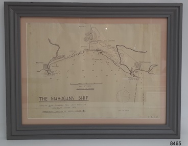
Document - Location Chart, The Mahogany Ship, 2007
This chart shows a possible site for the fabled wreck called the 'Mahogany Ship'. Flagstaff Hill’s collection includes other objects that some say could be relics from this Ancient Wreck, (also called the Gold Ship, or the Ancient Vessel). The chart shows the coordinates for the Summits of Griffith Island and of Middle Island. It also has the depths of the sea at various intervals and shows the shore and sand dunes, lighthouses and other reference points. The mystery of the Mahogany Ship began in 1836 when two shipwrecked sealers discovered the remains of an “ancient vessel” in the sand dunes about four miles west of Warrnambool. Since the last recorded sightings in the 1880’s the true origin of the Mahogany Ship has remained one of Australia’s most famous historical mysteries or fables. One of the more recent theories is that the vessel was one of the Portuguese ships exploring the Australian coast in 1522. For over one hundred years searchers have attempted to locate and identify the wreck. The search continues for the tangible evidence which will once and for all establish the Mahogany Ship’s place in Australia’s History.The chart represents the worldwide interest in locating the wreck of the Mahogany Ship. Locating the actual wreck or proving the existence of a Portuguese ship's wreck could change the history of the discovery of Australia. A Mahogany Ship committee was formed to gather and research information about the discovery of the wrecked ship. A large amount of money was offered as a prize for finding the wreck or parts of it. People have written books, painted images, made videos and told tales of the ship but it continues to remain a mystery or even a fable. The chart is significant for its possible link to one of Victoria’s and Australia’s maritime mysteries, the Mahogany Ship (also known as the Ancient Wreck). It is one of very few known relics that could give evidence of the existence and history of the vessel. It is listed on the Victorian Heritage Register S438 as it is one of Victoria’s oldest recorded shipwrecks. The identity of the vessel has the potential to change Australia’s history.A chart in a wooden frame, behind glass. The chart shows the approximate position of the mystery Ancient Wreck, later called the "Mahogany Ship". The chart is a copy and is based on the Admiralty Chart by Lieut. Stanley, dated 1872. Lower left: "THE MAHOGANY SHIP" "LOCALITY PLAN, ENLARGED FROM LIEUT. STANLEY'S ADMIRALTY CHART 1872" "APPROXIMATE POSITION OF WRECK MARKED [symbol of a Portuguese cross]" Other labels on chart: "BELFAST" "PORT FIARY" "GRIFFITHS I" "RIVER MOYNE" "RIVER MERRI" "ARMSTRONG BAY" " GORMANS LANE" "TOWER HILL" "KOROIT" "HELEN ROCK" "WARRNAMBOOL" "LADY BAY" "MIDDLE I" "LIGHT HO." Lower right: "G 410 B" Label on the back; "This chart presented to the Mahogany Ship Committee and Flagstaff Hill by Avis Quarrell, April 2007"warrnambool, shipwrecked coast, flagstaff hill maritime museum, shipwreck coast, mahogany ship, ancient vessel, ancient wreck, portuguese ship, coastal reserve, fabled wreck, gold ship, griffiths island, belfast (now port fairy), koroit, location plan, leuit. stanley, admiralty chart 1872, tower hill, merri river, moyne river, middle island, helen rock, armstrong bay, griffiths land -
 Flagstaff Hill Maritime Museum and Village
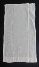
Ceremonial object - Maniple, 1907 to mid 20th century
This item is part of the collection of Ecclesiastical Linen once used by St. Andrews Anglican Church on the corner of the Esplanade and 14 Drummond St, Dennington, Victoria. The first Anglican service was conducted on December 22nd, 1907. The church was decommissioned in January 2003. This item is part of the Ecclesiastical Linen collection, which is significant for its examples of handworked embroidery and drawn-thread work from the early 20th century. The items are also examples of a collection used for religious services during this period. The Ecclesiastical Linen is also significant for its association with the early development of the local township of Dennington and the importance the the community of setting aside land in the 1850's for the purpose of religious worship. The Ecclesiastical Linen is also significant for its connection to St Andrews Anglican Church, Dennington. The church was funded and attended by the local community in the early 1900's and is now listed on the Victorian Heritage Database (VHD 118083) as a building of historical and social significance. Maniple, part of a set of Ecclesiastical Linen once used in St. Andrew's Anglican Church, Dennington, Victoria, between the years 1907 and 2003. Handmade Eucharist serving cloth, white fabric with white embroidery on one end, symbolising rope entwined around an anchor. flagstaff hill, warrnambool, maritime museum, shipwreck coast, great ocean road, st andrews anglican church dennington, dennington church, warrnambool church 1907, ecclesiastical linen, communion linen, maniple, eucharist, embroidered linen, hand worked linen, j.a. coe, rope and anchor emblem, religious service, religious ceremony, ceremonial linen, embroidered cloth