Showing 931 items
matching activity centre
-
 Ringwood and District Historical Society
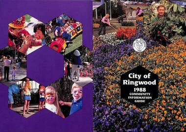
Booklet, City of Ringwood 1988 Community Information Guide, 1988
Community information booklet issued by City of Ringwood for 1988 - covering the facilities and activities of the Ringwood Council and other local organisations and associations. Cover photographs: Front - Floral displays at Clock Tower and a scene at Council nursery; Back - Activities at Ringwood Festival held at Ringwood Lake in April each year.CONTENTS: (page no.) After School Activities Programme 23 Aged Services 21 Bicentennial 15 Building Information 29 By-Laws and Traffic Regulations 31 Caravans/Mobile Homes 31 Chief Executive's Message 10 Children's Services 22 Churches 40 Civic Centre 4 Committees of Council 5 Community Plan 15 Community Services 35 Corporate Management Structure 11 Council Meeting Dates 4 Council Representatives 8 Councillors 6 & 7 Disabled Persons Facilities 42 Dogs 31 Domiciliary Care 24, 25 & 26 Elderly Day Care 44 Elderly Persons Units 29 Emergency Telephone Numbers 53 Employment Opportunities in Ringwood 26 European Wasps 28 Family Day Care 22 Finances 17 Fire Hazards 31 Future Leaders 16 Golf Course 34 Home Handyman Services 25 Home Help 26 Immunisation Programme 27 Incinerators 32 Knaith Road Child Care Centre 22 & 23 Library 30&31 Maternal & Child Health Centre 30 Mayoral Message – Cr. John R. Caffyn 3 Meals on Wheels 24 Members of Parliament 9 Playgroups 33 Pre-Schools 53 Primary Arterial Road Network in Ringwood 13 Rates—New Collection Service 18 & 19 Ringwood Aquatic Centre 14 & 15 Ringwood Bypass Road 12 Ringwood Convention & Performing Arts Centre 33 Ringwood District Centre Structure Plan 12 Rubbish Collection Service 35 & 36 Schools 56 Youth Outreach Worker 20 rinx -
 Ringwood and District Historical Society
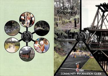
Booklet, City of Ringwood 1989 Community Information Guide, 1989
Community information booklet issued by City of Ringwood for 1989 - covering the facilities and activities of the Ringwood Council and other local organisations and associations. Cover photographs: Front - Fern Gully at Ringwood Lake, Poppett Head at rear of Lake, Athletics Track. Back - Highland Carnival, Wombalano Park, Miners Cottage at Ringwood Lake, Bike Path, Water Cascade at rear of Lake.CONTENTS: (page no.) 1. COUNCIL SERVICES After School Activities Programme 29 Aged Services 31, 32 & 33 Aquatic Centre 20 & 21 Budget 14 Building Information 16 By-Laws 26 Chief Executive's Message 9 Children's Services 29 Civic Centre 4 Committees of Council 5 Common Questions 36 Community Plan 10 & 11 Council Meeting Dates 4 Council Representatives 8 Councillors 6 & 7 Dogs 26 Dual Occupancy 12 Emergency Telephone Numbers 63 Family Day Care 29 Fire Hazards 27 Garbage 34 & 35 Golf Course 24 Home Handyman Services 31 Home Help 31 Incinerators 26 Knaith Road Child Care Centre 29 Library 23 Maternal and Child Health 28 Mayoral Message – Cr. R. Gardini 3 Meals on Wheels 31 Members of Parliament 62 Parks and Gardens 18 Rates 25 Residential Development Provisions 12 & 13 Ringwood Bypass Road 13 Ringwood Convention Centre & Performing Arts Centre 22 Ringwood District Centre 14 Staff 10 Town Planning 17 Works Depot 30 Youth Outreach Worker 33 2. LOCAL COMMUNITY SERVICES Accommodation 37 Alcoholism 37 Birthright 38 Blind 38 Care Force 39 Catholic Family Welfare Bureau 39 Central Ringwood Community Centre 39 Childbirth and Parenting Association 39 & 40 Churches 40 & 41 Community Services Victoria 42 Day Centres and Drop In Centres 43 Do Care 43 Drugs 43 Elderly Day Care 44 Emergency Housing 45 Family Planning Services 45 Financial Counselling 46 Hearing Aid Service 47 Hospitals 47 Housing 48 Information 48 Legal 49 Literacy 50 Lone Parents 50 Marriage Celebrants 50 Maroondah Social Health Centre 51 Neighbourhood Mediation Centre - Outer East 51 North Ringwood Community House 52 Nursing 52 Optometric Services 52 Playgroups 53 Podiatry 53 Pre-Schools 54 Red Cross 55 Retirement 55 Ringwood Croydon Advisory Service 55 Schools 56 & 57 Senior Citizens' Centres 58 Transport 59 Twins 59 Unemployment 60 Volunteering 60 Youth Accommodation Project (Maroondah). 60 Youth Emergency Accommodation Services... 60 rinx -
 Ringwood and District Historical Society
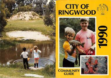
Booklet, City of Ringwood 1990 Community Guide, 1990
Community information booklet issued by City of Ringwood for 1990 - covering the facilities and activities of the Ringwood Council and other local organisations and associations.CONTENTS: (page no.) 1. COUNCIL SERVICES After School Programme 33 Aged Services 33, 34,35 Aquatic Centre 15,16,17 Aquatic Centre Bonus Vouchers 17 Biological Wasp Control 24 Budget 13,14 Building information 26 By-Laws 29 Chief Executive's Message 9 Children's Services 44 Citizenship 35 Civic Centre 4 Committees of Council 5 Common Questions 39 Council Meeting Dates 4 Council Representatives 8 Councillors 6,7 Dogs 29 Emergency Telephone Numbers 67 Family Day Care 32 Fire Hazards 29 Garbage 37 Golf Course 19 Health and Environmental Services 24 Home Handyman Services 54 Home Help 33 Immunisation 25 incinerators 29 Knaith Road Child Care Centre 32 Library 22 Library Service Senior Citizens 34 Maternal and Child Health 31 Mayoral Message - Cr. Lillian Rosewarne 3 Meals on Wheels 33 Members of Parliament 40 Parks and Gardens 22,23 Rates 28 Residential Development Provisions 12 Ringwood Bypass Road 11 Ringwood Convention Centre & Performing Arts Centre 20 Ringwood District Centre 13 Ringwood Festival 21 Shopping Bus 34 Staff 10 Town Planning 26 Works Depot 36 Youth Outreach Worker 36 2. LOCAL COMMUNITY SERVICES Accommodation 42 Aged Accommodation 42 Alcoholism 42 Arthritis Foundation 43 Arts and Crafts 43 Blind 43 Care Force 43 Catholic Family Welfare Bureau 43 Central Ringwood Community Centre 43 Childbirth and Parenting Association 44 Churches 45 Community Services Victoria 47 Day Centres and Drop-in Centres 48 Disabled Facilities 49 Do Care 50 Drugs 50 Elderly Day Care 50 Emergency Housing 51 Family Planning Services 51 Financial Counselling 52 Hearing Aid Service 53 Hospitals 54 Housing 54 Information 55 Legal 55 Literacy 55 Lone Parents 57 Marriage Celebrants 57 Maroondah Social Health Centre 57 Neighbourhood Mediation Centre - Outer East 57 North Ringwood Community House 53 Nursing 59 Optometric Services 59 Playgroups 60 Pre-Schools 60 Red Cross 61 Retirement 62 Ringwood Croydon Advisory Service 62 Schools 63 Senior Citizens' Centres 65 Transport 66 Twins 66 Unemployment 66 Volunteering 66 Youth Accommodation Project (Maroondah) 67 Youth Emergency Services 67 rinx -
 Ringwood and District Historical Society
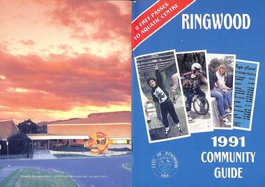
Booklet, City of Ringwood 1991 Community Guide, 1991
Community information booklet issued by City of Ringwood for 1991 - covering the facilities and activities of the Ringwood Council and other local organisations and associations. Includes 2 free passes to Ringwood Aquatic Centre.CONTENTS: (page no.) After School Programme 20 Aged Services 17 Aquatic Centre 12 Aquatic Centre Bonus Vouchers 14 Biological Wasp Control 35 Budget 10 Building Information 28 By-Laws 25 Chief Executive's Message 8 Children's Services 20 Citizenship 24 Civic Centre (i) Committees of Council 6 Common Questions 39 Council Meeting Dates 6 Council Representatives 7 Councillors 4 Dogs 25 Emergency Telephone Numbers 67 Family Day Care 44 Fire Hazards 31 Garbage 32 Golf Course 14 Health and Environmental Services 35 Home Help 52 Home Maintenance Services 17 Incinerators 31 Knaith Road Child Care Centre 21 Library 24 Library Services Senior Citizens 18 Maternal and Child Health 21 Mayoral Message – Cr. Betty Milton 1 Meals on Wheels 17 Members of Parliament 40 Parks and Gardens 26 Rates 10 Ringwood Convention Centre & Performing Arts Centre 15 Ringwood District Centre 10 Ringwood Festival 23 Shopping Bus 48 Town Planning 27 Works Depot 29 Youth Worker 19 rinx -
 Ringwood and District Historical Society
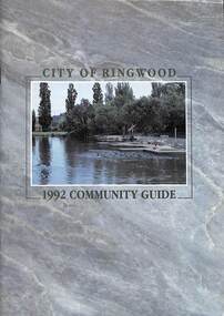
Book, City of Ringwood, City of Ringwood 1992 Community Guide, 1992
Community information book issued by City of Ringwood for 1992 - covering the facilities and activities of the Ringwood Council and other local organisations and associations. Includes two Aquatic Centre entry vouchers valid until June 30th, 1992.CONTENTS: (page no.) 1991/92 COUNCIL REPRESENTATIVES 4 1992 CALENDAR 51 AQUATIC CENTRE 8 AQUATIC CENTRE VOUCHERS 49 CHIEF EXECUTIVE'S REPORT 6 CIVIC CENTRE TELEPHONE INDEX — DIRECT DIALLING 53 COMMUNITY DIRECTORY 35-47 COMMUNITY SERVICES 17-19 COUNCIL & COMMITTEE CYCLES 4 COUNCIL FINANCES & 1991/92 RATES 16 COUNCILLORS 3 FUNCTIONAL RESPONSIBILITIES 15 HISTORY OF RINGWOOD 5 HOUSING & RESIDENTIAL DEVELOPMENT 29-30 INFRASTRUCTURE 34 LOCAL, STATE & FEDERAL GOVERNMENT ELECTIONS 32 MANAGEMENT TEAM 14 MAYORAL MESSAGE – Cr. Max Williams 1 NEIGHBOURHOOD MAP 26-27 NOTES 52 PAPER & CARDBOARD COLLECTION SERVICE 22 PARKS & RESERVES — PUBLIC FACILITIES 31 PROTECTING OUR COMMUNITY 23-24 PROTECTING THE ENVIRONMENT 20-21 RINGWOOD FESTIVAL & HIGHLAND CARNIVAL 13 RINGWOOD GOLF COURSE 7 STRATEGIC BIKE PLAN 11 STREET INDEX A-L 25 STREET INDEX L-Z 28 THE LIBRARY 12 THE RINGWOOD CONVENTION & PERFORMING ARTS CENTRE 10 TRAFFIC MANAGEMENT 33 YOUR PERSONAL DIRECTORY 50 rinx -
 Ringwood and District Historical Society
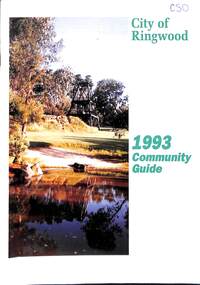
Book, City of Ringwood, City of Ringwood 1993 Community Guide, 1993
Community information book issued by City of Ringwood for 1993 - covering the facilities and activities of the Ringwood Council and other local organisations and associations. Includes two Ringwood Aquatic Centre bonus entry vouchers valid until June 30th, 1993. Cover photographs: Front - Poppet Head, Ringwood Lake; Back - Opening of North Ringwood Child Care Centre. CONTENTS: (page no.) Message from the Mayor – Cr. Greg Adkins, J.P. 3 Councillors 4 Council & Committee Cycle 5 Council Elections 6 History of Ringwood 7 Chief Executive's Report 8 The Management Team 9 Functional Responsibilities 10 Community Liaison 11 Council Expenditure for 1992/93 12 Rates and Valuations 13 COUNCIL SERVICES Community Services 14 Protecting the Environment 17 Protecting Our Community 19 Town Planning 21 Building 22 Design and Investigation 23 Works 24 Street Index - Electoral Wards 25 Neighbourhood Map 26 and 27 COUNCIL RECREAION AND LEISURE FACILITIES Ringwood Golf Course 29 Aquatic Centre 30 The Ringwood Convention Centre 32 Ringwood Library 34 Ringwood Recreation 35 Parks and Reserves 30 Community Directory 38-50 Community Information Data Bank 51 Aquatic Centre Vouchers 51rinx -
 Ringwood and District Historical Society
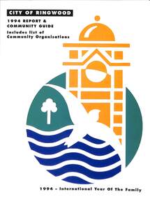
Book, City of Ringwood, City of Ringwood 1994 Report & Community Guide, 1994
The City of Ringwood and the City of Croydon merged in December 1994 and became the City of Maroondah.Community information book issued by City of Ringwood for 1994 - covering the facilities and activities of the Ringwood Council and other local organisations and associations. Includes Ringwood Public Golf Course discount vouchers and two Ringwood Aquatic Centre bonus entry vouchers.CONTENTS: (page no.) Contents A Message from the Mayor - Cr. Margaret Cheevers 3 Your Council 4 Local State and Federal MPs 5 Council Meetings and Elections 6 History of Ringwood 7 City Manager's Report 8 Organisational structure 9 Human Services 10-19 Environmental Health 20-21 Ringwood Library 22 Parks and Gardens 23 Ringwood's Parks and Reserves 24 Building 25 Engineering Planning Services 26-28 Waste Management 29 Town Planning 30 Traffic and Local Laws 31-33 Roads, Drainage and Major Works 38-39 Halls and Facilities 40-41 Aquatic Centre 42 Convention Centre/Karralika Theatre 43 Golf Course 44 Free Swim & Golf Discount Vouchers 45 Community Organisations 46-64 Finance 65-66 Administration 67 Community Liaison 68 Information Systems 69 Personnel 70-71 Risk Management 71 Rates and Valuations 72 rinx -
 Ringwood and District Historical Society
Plastic packet, PTC - Maroondah City Council, Public Transport Commission, Ringwood Railway Station Development Study, Interchange Upgrade, Community Workshops - various printed documents 1995-2013, 1995 to 2013
The urban consulting group commissioned Maroondah City Council and the Public Transport Feasibility Study, Ringwood Railway Station to be upgraded October 1995Various printed documents relating to PTC (Public Transport Commission), Maroondah City Council, Department of Transport - Ringwood Railway Station Redevelopment Study October 1995, Ringwood Station Bus interchange upgrade, designing new look Ringwood Station. Workshops were held for the community. +Additional Keywords: Ringwood Station Bus Interchange upgrade feed back sheet October 2011 / Ringwood Station Precinct Redevelopment Workshop held 26 July 2011 / Ringwood Station and bus upgrade December 2011 / Ringwood Town Centre South Project / Precinct Plans Planning Report. / Ringwood Town Centre Draft Report November 2000 / Ringwood Activities Community Newsletter August 2011 - Ringwood Station Update / State Government to sell Central Ringwood Railway land - Herald Sun 30 December 2013 / Ringwood Town Centre Precinct 4 Station Superblock for Railway Station July 2009 / Media release $66m station 15 April 2015 / Ringwood Station and Interchange Upgrade, Wednesday 27 August 2014 / Lifts left off upgrade plan - Leader Community Paper, 10 December 2013 / How to submit your feedback - Ringwood Station Precinct proposed concept, December 2011 / Designing a new look Ringwood Station workshop handout / State Government announces $66 million redevelopment of Ringwood Train Station, Herald Sun 6 June 2013 / Ringwood Station and bus interchange upgrade project update July 2012 / Set Concept design plans of $66 million Ringwood Railway Station over the years / Set photos of Ringwood Station taken between 2004 to 2005 / A3 drawing - Plan of Ringwood Station / A3 drawing - Ringwood Station proposed layout / A3 drawing - Old Station, Ringwood / A3 drawing - Proposed plan 2011 / A4 drawing - Final plan of Ringwood Station 2014 / A4 drawing - Proposed plan 2010 Ringwood Railway Station / A3 drawing - Proposed plan Ringwood Station with bridge across Maroondah Highway -
 Bendigo Military Museum
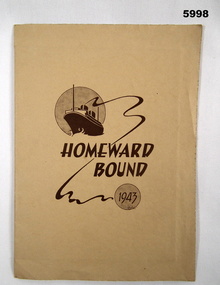
Booklet - BOOKLET, HOMEWARD BOUND 1943
Booklet was relating to the voyage home by ship of soldiers and other military support personnel who had been on active duty in the Middle East in 1943. New task was to fight the Japanese. Item in collection relating to David Patterson,24 page booklet on yellow paper with black writing and black and white pictures. Contains series of articles on action in the Middle East. Poems and stories and descriptions of activities aboard the ship taking troops back to Australia. In centre was series of pictures of life on board. Booklet bound be cardboard cover and stapled together.return to australia, homeward bound, middle east, ww2 -
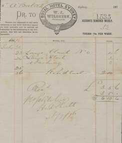 Warrnambool and District Historical Society Inc.
Document, Account weekly Royal Hotel Sydney 1876, 1876
One of a number of papers which relate to Augustus Bostock, this account shows charges for weekly lodgings and drinks. Augustus Bostock was the 9th child of Robert & Rachael Bostock of Vaucluse Epping Forest, Van Diemen’s Land. He was only 4 years old when his mother died. He was inspired by his father to seek his fortune in the Western District of Victoria. He arrived around 1850. He married Margaret Aitkin in July 1865. Augustus owned several properties in the district and leased others. He sat on the court of Warrnambool, Mortlake or Hexham as required. He resided at Marramook in Hawkesdale and later moved to Vaucluse in Hopetoun Road Warrnambool, where he died in 1920 at the age of 87. He was involved in many aspects of life in the Western District, racing, cricket, and social activities to name a few. This is one of a number of documents which relate to the Bostock family who were one of the most important pioneering families of the Western District. They owned and leased various properties around Warrnambool and were involved in many aspects of social and business life. Cream lined paper lined in blue and red. Logo centre top. Details handwritten in black ink.Royal Hotel Sydney W.J. Wilshire proprietor.warrnambool, augustus bostock, bostock, 1876, w j wilshire, -
 Warrnambool and District Historical Society Inc.
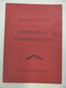
Publication, Constitution Warrnambool Boomerang Club, Mid 20th Century
This is the Constitution of the Warrnambool Boomerang Club. The Boomerang Club was a social club that was formed some time in 1934 and continued until at least 1956. By the late 1930s there were nearly 200 members who took part in activities that included dinners, balls, dances, Christmas parties and picnics. Profits from the Boomerang Club functions were donated to local charitable organizations. This is a significant item as the Boomerang Club was an important social group in Warrnambool in the mid 20th century. This is a small booklet of four pages, two double-sided and two with printing on one side only. It has a red cover and contains printed material. It has an image of a boomerang on the front cover. The pages were originally stapled.Front cover: ‘Constitution of the Warrnambool Boomerang Club, Collett and Munday, Printers, 254 Timor Street, Warrnambool’ The Boomerang image has the word ‘Club’ in the centre warrnambool boomerang club -
 Warrnambool and District Historical Society Inc.
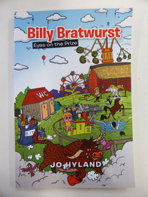
Book, Billy Bratwurst, 2013
... -coloured with many comic images centred around the activities.... The cover is multi-coloured with many comic images centred around ...This is a fictional story about a small boy growing up in rural Australia. The author, Jo Hyland, lives in Woolsthorpe. The story, written in a light-hearted way, is suitable for adults and older children. This book is of minor interest as it was written by a resident of Woolsthorpe, a small town in the Warrnambool district. This is a soft cover book of 134 pages. The cover is multi-coloured with many comic images centred around the activities of a small boy. The book contains 22 chapters. jo hyland, history of warrnambool -
 Kiewa Valley Historical Society
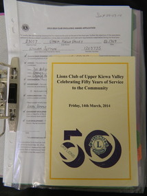
Folder - Upper Kiewa Valley Lions Club 2010 - 2015 & Booklet, Lions Club of Upper Kiewa Valley Celebrating Fifty Years of Service to the Community, 2010 - 2015
The Upper Kiewa Valley Lions Club was established in March 1964 and celebrated 50 years in 2014.Residents of the Kiewa Valley belonged to the Upper Kiewa Valley Lions Club. They are/were involved in many community activities and services eg. The Take Away shop at Falls Creek, Christmas carols, the conquestathon Purple folder with Upper Kiewa Valley Lions Club with correspondence and summary forms covering 1010 - 1015. Includes members names. Booklet is yellow with black heading and '50' with green Lions insignia inside the O.lions club; upper kiewa valley; 50th anniversary; community service -
 Kiewa Valley Historical Society
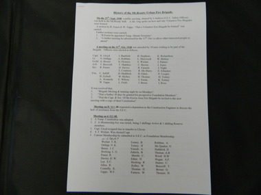
Papers - History of the Mt Beauty Fire Brigade
The Mt Beauty Fire Brigade commenced under the State Electricity Commission of Victoria in 1948. It was a (Country Fire Authority) C.F.A. Brigade from December 1961 and later an Urban Fire Brigade. The Fire Brigade and its Ladies Auxillary provided many community activities as well as protecting the population.The State Electricity Commission of Victoria established the Mt Beauty Fire Brigade during the construction of the Kiewa Hydro Electric Scheme. Its Ladies Auxillary was very active and involved, serving the community by raising money for the brigade and providing social occasions such as 'Deb' balls.One set of two pages and one set of eleven pages of the History of the Mt Beauty Fire Brigade and Mt Beauty Urban Fire Brigade respectively. Typed and photocopies.mt beauty fire brigade; ladies auxillary; deb balls -
 Kiewa Valley Historical Society
Photo - Bogong Township, March 1944
In 1940 Field Headquarters for the Kiewa Scheme were established at Bogong with office, workshop facilities and accommodation for workmen, staff and some families constructed. (There had been a 'tent camp' on this site in 1939 but was destroyed by bushfires) Construction of accommodation continued until 1947. A total of 40 houses plus a hostel for single staff, post office, police station, medical centre and primary school all with water and sewerage and electricity supply. The staff hostel was known as Kiewa House and is now occupied by the Education Department. Lake Guy was named after Mr. L.T. Guy who was the Resident Engineer in charge of construction work and associated activities on the Kiewa area. He held this position from 1939 to November 1946 when he was transferred to Head Office. The Bogong Township was developed firstly as an accommodation centre (base camp) for construction workers employed under the Kiewa Hydroelectric Scheme. Due to the influx of European workers into the Township the beautification of the immediate surrounds (gardens etc.) had a distinct European flavour. This environment has been very beneficial for tourism in later years. At the completion of the scheme, in the 1960's, the village was opened to public/tourism use. Strict environmental control has not allowed for any extensive redevelopment in tourist accommodation and basically restricted it to the accommodation initially built for the construction workers. Activities such a bike riding, snow skiing, restricted horse riding and bush walking on the Alpine plains and mountains are now a viable part of the Kiewa Valley Tourist Industry. The lake is one of the many water storage reservoirs used to supply the power stations their main power to run the huge turbines generating the final product, electricityBlack and white photograph of Bogong Township taken March 1944Handwritten on the back of photo - Township March '44bogong village, secv -
 Kiewa Valley Historical Society
Photograph - Bogong Village (7 copies), Approx 1940
In 1940 Field Headquarters for the Kiewa Scheme were established at Bogong with office, workshop facilities and accommodation for workmen, staff and some families constructed. (There had been a 'tent camp' on this site in 1939 but was destroyed by bushfires) Construction of accommodation continued until 1947. A total of 40 houses plus a hostel for single staff, post office, police station, medical centre and primary school all with water and sewerage and electricity supply. The staff hostel was known as Kiewa House and is now occupied by the Education Department. Lake Guy was named after Mr. L.T. Guy who was the Resident Engineer in charge of construction work and associated activities on the Kiewa area. He held this position from 1939 to November 1946 when he was transferred to Head Office. The Bogong Township was developed firstly as an accommodation centre (base camp) for construction workers employed under the Kiewa Hydroelectric Scheme. Due to the influx of European workers into the Township the beautification of the immediate surrounds (gardens etc.) had a distinct European flavour. This environment has been very beneficial for tourism in later years. At the completion of the scheme, in the 1960's, the village was opened to public/tourism use. Strict environmental control has not allowed for any extensive redevelopment in tourist accommodation and basically restricted it to the accommodation initially built for the construction workers. Activities such a bike riding, snow skiing, restricted horse riding and bush walking on the Alpine plains and mountains are now a viable part of the Kiewa Valley Tourist Industry. The lake is one of the many water storage reservoirs used to supply the power stations their main power to run the huge turbines generating the final product, electricity. Evidence can be seen of the 1939 bushfires.Set of 7 identical black and white photographs of Bogong Village after 1939 bush firesHandwritten on the back of one photo - Bogong Village approx. 1940, after 1939 bush fires. Staff residences to left. Kiewa House, General offices and test lab to the right. Hand drawn map on the back of one photo.bogong village, secv -
 Kiewa Valley Historical Society
Photo - Bogong Village Township, October 8, 1946
In 1940 Field Headquarters for the Kiewa Scheme were established at Bogong with office, workshop facilities and accommodation for workmen, staff and some families constructed. (There had been a 'tent camp' on this site in 1939 but was destroyed by bushfires) Construction of accommodation continued until 1947. A total of 40 houses plus a hostel for single staff, post office, police station, medical centre and primary school all with water and sewerage and electricity supply. The staff hostel was known as Kiewa House and is now occupied by the Education Department. Lake Guy was named after Mr. L.T. Guy who was the Resident Engineer in charge of construction work and associated activities on the Kiewa area. He held this position from 1939 to November 1946 when he was transferred to Head Office. The Bogong Township was developed firstly as an accommodation centre (base camp) for construction workers employed under the Kiewa Hydroelectric Scheme. Due to the influx of European workers into the Township the beautification of the immediate surrounds (gardens etc.) had a distinct European flavour. This environment has been very beneficial for tourism in later years. At the completion of the scheme, in the 1960's, the village was opened to public/tourism use. Strict environmental control has not allowed for any extensive redevelopment in tourist accommodation and basically restricted it to the accommodation initially built for the construction workers. Activities such a bike riding, snow skiing, restricted horse riding and bush walking on the Alpine plains and mountains are now a viable part of the Kiewa Valley Tourist Industry. The lake is one of the many water storage reservoirs used to supply the power stations their main power to run the huge turbines generating the final product, electricityBlack and white photograph of Bogong Village which appeared in the Herald Sun newspaper on October 8, 1946. Page 13Handwritten on the back - Town of Bogong on a rugged mountain slope above Lake Guy. State Electricity Committee workers on the Kiewa Hydro Electric scheme live here in all electric homes. Stamped on the back - Copyright Not for reproduction Herald Sun Feature Service Melbourne Australiabogong village; lake guy; kiewa hydro electric scheme -
 Kiewa Valley Historical Society
Postcard - Lake Guy and Bogong Village
In 1940 Field Headquarters for the Kiewa Scheme were established at Bogong with office, workshop facilities and accommodation for workmen, staff and some families constructed. (There had been a 'tent camp' on this site in 1939 but was destroyed by bushfires) Construction of accommodation continued until 1947. A total of 40 houses plus a hostel for single staff, post office, police station, medical centre and primary school all with water and sewerage and electricity supply. The staff hostel was known as Kiewa House and is now occupied by the Education Department. Lake Guy was named after Mr. L.T. Guy who was the Resident Engineer in charge of construction work and associated activities on the Kiewa area. He held this position from 1939 to November 1946 when he was transferred to Head Office. The Bogong Township was developed firstly as an accommodation centre (base camp) for construction workers employed under the Kiewa Hydroelectric Scheme. Due to the influx of European workers into the Township the beautification of the immediate surrounds (gardens etc.) had a distinct European flavour. This environment has been very beneficial for tourism in later years. At the completion of the scheme, in the 1960's, the village was opened to public/tourism use. Strict environmental control has not allowed for any extensive redevelopment in tourist accommodation and basically restricted it to the accommodation initially built for the construction workers. Activities such a bike riding, snow skiing, restricted horse riding and bush walking on the Alpine plains and mountains are now a viable part of the Kiewa Valley Tourist Industry. The lake is one of the many water storage reservoirs used to supply the power stations their main power to run the huge turbines generating the final product, electricityBlack and white photographic postcard of Lake Guy and Bogong Village. Kiewa Hydro electric Project (showing Junction Dam in front)Handwritten on the back of postcard ' Like most of our camps, this looks like something from the Canadian Rockies' Stamped on the back - Valentine's Post Card A genuine photographlake guy, bogong village, secv -
 Kiewa Valley Historical Society
Photo - Bogong Township, September 1953
In 1940 Field Headquarters for the Kiewa Scheme were established at Bogong with office, workshop facilities and accommodation for workmen, staff and some families constructed. (There had been a 'tent camp' on this site in 1939 but was destroyed by bushfires) Construction of accommodation continued until 1947. A total of 40 houses plus a hostel for single staff, post office, police station, medical centre and primary school all with water and sewerage and electricity supply. The staff hostel was known as Kiewa House and is now occupied by the Education Department. Lake Guy was named after Mr. L.T. Guy who was the Resident Engineer in charge of construction work and associated activities on the Kiewa area. He held this position from 1939 to November 1946 when he was transferred to Head Office. The Bogong Township was developed firstly as an accommodation centre (base camp) for construction workers employed under the Kiewa Hydroelectric Scheme. Due to the influx of European workers into the Township the beautification of the immediate surrounds (gardens etc.) had a distinct European flavour. This environment has been very beneficial for tourism in later years. At the completion of the scheme, in the 1960's, the village was opened to public/tourism use. Strict environmental control has not allowed for any extensive redevelopment in tourist accommodation and basically restricted it to the accommodation initially built for the construction workers. Activities such a bike riding, snow skiing, restricted horse riding and bush walking on the Alpine plains and mountains are now a viable part of the Kiewa Valley Tourist Industry. The lake is one of the many water storage reservoirs used to supply the power stations their main power to run the huge turbines generating the final product, electricityBlack and white photograph of Bogong Township taken from Little Arthur fire track. September 1953Faded handwritten inscription on back - Bogong Township taken from Little Arthur fire track. Sept 1953bogong village, secv -
 Kiewa Valley Historical Society
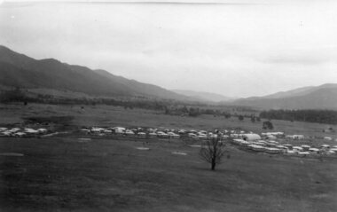
Photo - First Bogong Camp, September 1950
In 1940 Field Headquarters for the Kiewa Scheme were established at Bogong with office, workshop facilities and accommodation for workmen, staff and some families constructed. (There had been a 'tent camp' on this site in 1939 but was destroyed by bushfires) Construction of accommodation continued until 1947. A total of 40 houses plus a hostel for single staff, post office, police station, medical centre and primary school all with water and sewerage and electricity supply. The staff hostel was known as Kiewa House and is now occupied by the Education Department. Lake Guy was named after Mr. L.T. Guy who was the Resident Engineer in charge of construction work and associated activities on the Kiewa area. He held this position from 1939 to November 1946 when he was transferred to Head Office. The Bogong Township was developed firstly as an accommodation centre (base camp) for construction workers employed under the Kiewa Hydroelectric Scheme. Due to the influx of European workers into the Township the beautification of the immediate surrounds (gardens etc.) had a distinct European flavour. This environment has been very beneficial for tourism in later years. At the completion of the scheme, in the 1960's, the village was opened to public/tourism use. Strict environmental control has not allowed for any extensive redevelopment in tourist accommodation and basically restricted it to the accommodation initially built for the construction workers. Activities such a bike riding, snow skiing, restricted horse riding and bush walking on the Alpine plains and mountains are now a viable part of the Kiewa Valley Tourist Industry. The lake is one of the many water storage reservoirs used to supply the power stations their main power to run the huge turbines generating the final product, electricityBlack and white photo of Bogong Village. September 1950Handwritten on the back - 1st Bogong Camp. SEC Kiewa Scheme Sept 1950bogong camp, bogong village, secv -
 Kiewa Valley Historical Society
Photo - Bogong Village Township
In 1940 Field Headquarters for the Kiewa Scheme were established at Bogong with office, workshop facilities and accommodation for workmen, staff and some families constructed. (There had been a 'tent camp' on this site in 1939 but was destroyed by bushfires) Construction of accommodation continued until 1947. A total of 40 houses plus a hostel for single staff, post office, police station, medical centre and primary school all with water and sewerage and electricity supply. The staff hostel was known as Kiewa House and is now occupied by the Education Department. Lake Guy was named after Mr. L.T. Guy who was the Resident Engineer in charge of construction work and associated activities on the Kiewa area. He held this position from 1939 to November 1946 when he was transferred to Head Office. The Bogong Township was developed firstly as an accommodation centre (base camp) for construction workers employed under the Kiewa Hydroelectric Scheme. Due to the influx of European workers into the Township the beautification of the immediate surrounds (gardens etc.) had a distinct European flavour. This environment has been very beneficial for tourism in later years. At the completion of the scheme, in the 1960's, the village was opened to public/tourism use. Strict environmental control has not allowed for any extensive redevelopment in tourist accommodation and basically restricted it to the accommodation initially built for the construction workers. Activities such a bike riding, snow skiing, restricted horse riding and bush walking on the Alpine plains and mountains are now a viable part of the Kiewa Valley Tourist Industry. The lake is one of the many water storage reservoirs used to supply the power stations their main power to run the huge turbines generating the final product, electricityBlack and white photograph of Bogong Village from across Lake Guy. Photo mounted on buff cardbogong village, secv -
 Kiewa Valley Historical Society
Photograph - Mt Beauty Community Centre original colour plan and photos of upgrade in 2000, 1. Dated March 22nd, 1962 2. Photographs taken during renovations in 2000
The Community Centre was built in the early 1950’s as an all-purpose hall for the social and recreational use of the workers and families employed on the Victorian state government Kiewa Hydro-electric scheme. The hall was originally called Mt Beauty Recreation Centre and later changed to Mt Beauty Community Centre. It has been the heart of the community for over 65 years and had a heritage listing put on it around the year 2000. The Alpine Shire secured a heritage grant and the hall was restored to its former glory in 2000. In heritage circles it is claimed that the hall is the best example of a 1950’s construction town community hall, which is still functioning anywhere in AustraliaThe Community Centre was and is a very important part of life in the small remote community of Mount Beauty and a range of activities have taken place in the Community Centre over the past 65 years- Picture theatre; Dances and balls; A physical education and boxing club run by Alex McCollough for 30 years; School and social club concerts; Girls gymnastics; Drama group productions, revues and pantomimes; Callisthetics and ballet; Badminton; Wedding receptions and birthday parties; Music festival events; Staging area in times of natural disaster; The library for many years; Shire and community meetings; Secondary College gymnasium for many years and shelter for the Community Market in inclement weather 1 – 1972 specifications for colour scheme of original Mt Beauty Recreation centre, Typed on buff foolscap paper with small colour swatches and letter of explanation to Mr A.J. McCullough. 2 – Set of 10 colour photographs of the upgrade and extension to Mt Beauty Community Centre undertaken in 2000. Photos mounted 2 to a page on blue copy paper. 3. Second copy of No.1 above. Also - typed A4 sheet re history of "The Mount Beauty Community Centre"1 – Header on pages-Mate’s Colour Bar Personal Colour Scheme for Recreation Centre Mt Beauty Vic. 21/3/62. Accompanying letter to A.J McCullough signed by Colour Consultant Ena Chatuein 2. First page of photos, written in black felt marker – Mt Beauty Community Centre 30/11/00 mt beauty, community centre -
 Kiewa Valley Historical Society
Photographs x 2 - 1. Mt Beauty Camp 2. Bogong Camp, Photo 1 - September 1950
Mt Beauty Camp- The new State Electricity Commission construction camp at the head of the Kiewa Valley was for workmen on the second power station in the project expected to be the most modern and best equipped in Australia… In contrast to the early Kiewa days of horses and canvas tents, the new camp, with its modern amenities, compared favourably with any country town. Administration of the Kiewa Scheme was moved from Tawonga to Mount Beauty in 1946. The first house in Mount Beauty, in Hollonds Street, was occupied by the co-op store manager from November 1946. The new Mess Hall at Mt Beauty was opened with much ceremony in early November 1946. The houses up to Nelse street were erected from 1946 onward and then the township was extended beyond Nelse Street in 1950. The workmen's camp was enlarged in 1950 to the extent of providing accommodation for a total of 1,200. Bogong Camp - In 1940 Field Headquarters for the Kiewa Scheme were established at Bogong with office, workshop facilities and accommodation for workmen, staff and some families constructed. (There had been a 'tent camp' on this site in 1939 but was destroyed by bushfires) Construction of accommodation continued until 1947. A total of 40 houses plus a hostel for single staff, post office, police station, medical centre and primary school all with water and sewerage and electricity supply. The staff hostel was known as Kiewa House and is now occupied by the Education Department. Lake Guy was named after Mr. L.T. Guy who was the Resident Engineer in charge of construction work and associated activities on the Kiewa area. He held this position from 1939 to November 1946 when he was transferred to Head Office. Both Bogong Village and Mt Beauty were developed to accommodate workmen on the Kiewa Hydro Electric Scheme but have since become centres for tourism and a range of outdoor activities.1. Black and white photograph of Mount Beauty Camp taken in September 1950 2. Black and white photograph of Bogong Village Camp1. Written on the back in grey lead - Sept 1950. Mt Beauty Camp. HT Cooper own taking 2. Stamped on back of photograph - Copyright. Not for reproduction. Herald Sun feature Service. Melbourne Australiamt beauty camp, bogong camp, secv -
 Kiewa Valley Historical Society
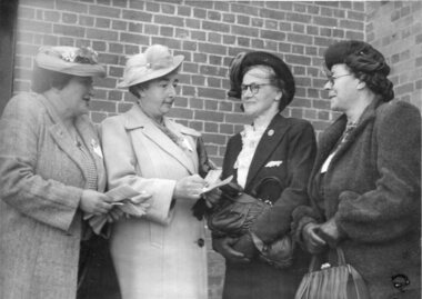
Photograph - Local CWA members at CWA conference, Circa Sept 1949
Local ladies representing the Kiewa Valley at conference for Upper Murray group of Country Women's Association (CWA) in September 1949History of involvement in community activities by local women of the Kiewa Valley, Mrs Larkin remains an active member of several local community groups (as of July 2017)Black and white photograph of local Kiewa Valley CWA members attending Upper Murray CWA group conference in 1949. Photograph appeared in the ?Weekly Times newspaper September 14, 1949Handwritten on back of photograph - In WT-CWA conference Upper Murray. Mesdames T. Eveston & W. Eveston (Kiewa) and H.E. Larkin & R.H. Coad (Tawonga) Sept 14, 1949. Page 75 in WT (Weekly Times) Handwritten on back of photograph along the bottom, Return to Gibson envelopecwa, kiewa valley group of cwa -
 Kiewa Valley Historical Society
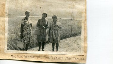
Photographs x 2- Groups of Kiewa Valley residents on tour of Khancoban area
Demonstrates a pictorial history of social activities undertaken by Kiewa Valley residents during this period possibly 1970’s to 1980’s. Also a pictorial record of residents of the Kiewa Valley during this period. Photographs demonstrate local Kiewa Valley residents enjoying a community visit to the Khancoban area, which holds significance to the early history of the district. Its heritage is celebrated in Banjo Paterson’s epic poem, “The Man from Snowy River”. 2 black and white photographs mounted on buff card. 1. Group of ladies on a tour of the Khancoban area 2. Mixed group of ladies and men on a tour of the Khancoban area 1. Handwritten in black ink below photo 'Mrs Van Der Weyde, Mrs Storey, Mrs Temple 2. Handwritten in black pen below photo 'A.O. Smith, A. Angus, Mrs. Pullin, S. Ross, C. Roper, Mrs Temple, A. E. Campbell (name of last person obscured)kiewa valley residents, clare roper -
 Kiewa Valley Historical Society
Photographs x 2 1. Lake Guy & Bogong Village 2. Bulldozer moving rocks
1. In 1940 Field Headquarters for the Kiewa Scheme were established at Bogong with office, workshop facilities and accommodation for workmen, staff and some families constructed. (There had been a 'tent camp' on this site in 1939 but was destroyed by bushfires) Construction of accommodation continued until 1947. A total of 40 houses plus a hostel for single staff, post office, police station, medical centre and primary school all with water and sewerage and electricity supply. The staff hostel was known as Kiewa House and is now occupied by the Education Department. Lake Guy was named after Mr. L.T. Guy who was the Resident Engineer in charge of construction work and associated activities on the Kiewa area. He held this position from 1939 to November 1946 when he was transferred to Head Office. 2. Example of the type of heavy machinery used in clearing and building of Lake Guy, Bogong Village and Clover Dam 1. The Bogong Township was developed firstly as an accommodation centre (base camp) for construction workers employed under the Kiewa Hydroelectric Scheme. At the completion of the scheme, in the 1960's, the village was opened to public/tourism use. Strict environmental control has not allowed for any extensive redevelopment in tourist accommodation and basically restricted it to the accommodation initially built for the construction workers. Lake Guy is one of the many water storage reservoirs used to supply the power stations their main power to run the huge turbines generating the final product, electricity 2. Pictorial record of the types of machinery used in the development of Bogong Village and the Hydro-electricity scheme including the Clover Dam. Note the lack of safety equipment worn by construction workers of the period. 2 black and white photographs taken at Bogong 1. Lake Guy with Bogong Village in the background 2. Workman in bulldozer clearing rocks, possibly for construction at Bogong1. Handwritten in blue ink on back of photo 'Lake Guy showing Bogong Village' 2. No markingslake guy, bogong village, secv -
 Kiewa Valley Historical Society
Photographs – Kiewa Cres Mt Beauty. Circa 1993. Set of 12 colour photographs
Established in 1946, during the construction of the Kiewa Hydro Electric Scheme, the township of Mt Beauty was developed by the State Electricity Commission of Victoria to provide additional accommodation for the thousands of workers during the construction of the country’s second largest hydro-electricity scheme. Although these towns were built as temporary accommodation for the workers and their families, many stayed after the scheme finished. Combined with the influx of European migrants, with their rich cultural backgrounds, all played a major part in shaping the future character of the Mount Beauty, the Kiewa Valley and Falls Creek. The Bright Council, now the Alpine Shire took over the control of the township in 1960. This relatively young town of Mount Beauty, along with the surrounding townships of Falls Creek, Bogong, Tawonga South and Tawonga, are all part of a prospering tourist area with excellent services, accommodation, food and a wide range of recreational activities available for all ages. According to Shire records, the population of Mt Beauty has grown from 1,500 in 1981 to 1,800 in 2016 with a projected increase to 2,000 in 2013The photographs taken around 1993 show a prosperous commercial centre catering for both locals and the needs of visitors. It provides a pictorial history of the changes which have occurred in the retail/commercial district of Mt Beauty over the years. It also demonstrates the attention paid by Alpine Shire towards providing accessible recreational green space around the town centre.Set of 12 colour photographs of Kiewa Cres Mt Beauty. Circa 1993 showing retail services and streetscape of the time. No markingskiewa cres mt beauty, mt beauty -
 Kiewa Valley Historical Society
Photographs – Lakeside Avenue, Mt Beauty. Circa 1993. Set of 7 colour photographs
Established in 1946, during the construction of the Kiewa Hydro Electric Scheme, the township of Mt Beauty was developed by the State Electricity Commission of Victoria to provide additional accommodation for the thousands of workers during the construction of the country’s second largest hydro-electricity scheme. Although these towns were built as temporary accommodation for the workers and their families, many stayed after the scheme finished. Combined with the influx of European migrants, with their rich cultural backgrounds, all played a major part in shaping the future character of the Mount Beauty, the Kiewa Valley and Falls Creek. The Bright Council, now the Alpine Shire took over the control of the township in 1960. This relatively young town of Mount Beauty, along with the surrounding townships of Falls Creek, Bogong, Tawonga South and Tawonga, are all part of a prospering tourist area with excellent services, accommodation, food and a wide range of recreational activities available for all ages. According to Shire records, the population of Mt Beauty has grown from 1,500 in 1981 to 1,800 in 2016 with a projected increase to 2,000 in 2013The photographs taken around 1993 show a prosperous commercial centre catering for both locals and the needs of visitors. It provides a pictorial history of the changes which have occurred in the retail/commercial district of Mt Beauty over the years. It also demonstrates the attention paid by Alpine Shire towards providing accessible recreational green space around the town centre.Set of 7 colour photographs of Lakeside Avenue, Mt Beauty. Circa 1993 showing retail services and streetscape of the time. No markingsmt beauty, lakeside ave mt beauty -
 Kiewa Valley Historical Society
Photographs – Tawonga Cres., Mt Beauty. Circa 1993. Set of 4 colour photographs
Established in 1946, during the construction of the Kiewa Hydro Electric Scheme, the township of Mt Beauty was developed by the State Electricity Commission of Victoria to provide additional accommodation for the thousands of workers during the construction of the country’s second largest hydro-electricity scheme. Although these towns were built as temporary accommodation for the workers and their families, many stayed after the scheme finished. Combined with the influx of European migrants, with their rich cultural backgrounds, all played a major part in shaping the future character of the Mount Beauty, the Kiewa Valley and Falls Creek. The Bright Council, now the Alpine Shire took over the control of the township in 1960. This relatively young town of Mount Beauty, along with the surrounding townships of Falls Creek, Bogong, Tawonga South and Tawonga, are all part of a prospering tourist area with excellent services, accommodation, food and a wide range of recreational activities available for all ages. According to Shire records, the population of Mt Beauty has grown from 1,500 in 1981 to 1,800 in 2016 with a projected increase to 2,000 in 2013The photographs taken around 1993 show a prosperous commercial centre catering for both locals and the needs of visitors. It provides a pictorial history of the changes which have occurred in the retail/commercial district of Mt Beauty over the years. It also demonstrates the attention paid by Alpine Shire towards providing accessible recreational green space around the town centre.Set of 4 colour photographs Tawonga Crescent, Mt Beauty. Circa 1993 showing retail services and streetscape of the time No markingstawonga cres mt beauty -
 Kiewa Valley Historical Society
Photographs – Holland Street North, Mt Beauty. Circa 1993. Set of 18 colour photographs
Established in 1946, during the construction of the Kiewa Hydro Electric Scheme, the township of Mt Beauty was developed by the State Electricity Commission of Victoria to provide additional accommodation for the thousands of workers during the construction of the country’s second largest hydro-electricity scheme. Although these towns were built as temporary accommodation for the workers and their families, many stayed after the scheme finished. Combined with the influx of European migrants, with their rich cultural backgrounds, all played a major part in shaping the future character of the Mount Beauty, the Kiewa Valley and Falls Creek. The Bright Council, now the Alpine Shire took over the control of the township in 1960. This relatively young town of Mount Beauty, along with the surrounding townships of Falls Creek, Bogong, Tawonga South and Tawonga, are all part of a prospering tourist area with excellent services, accommodation, food and a wide range of recreational activities available for all ages. According to Shire records, the population of Mt Beauty has grown from 1,500 in 1981 to 1,800 in 2016 with a projected increase to 2,000 in 2013The photographs taken around 1993 show a prosperous commercial centre catering for both locals and the needs of visitors. It provides a pictorial history of the changes which have occurred in the retail/commercial district of Mt Beauty over the years. It also demonstrates the attention paid by Alpine Shire towards providing accessible recreational green space around the town centre.Set of 18 colour photographs Holland Street North, Mt Beauty. Circa 1993 showing retail services and streetscape of the time. No markingsholland st mt beauty, mt beauty