Showing 1964 items matching " bourke"
-
 Melbourne Tram Museum
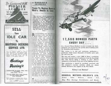
Magazine, Truck and Bus Transportation, "Trams to Replace buses in Melb's Bourke St Lines", Sep. 1943
Magazine cutting or photocopy of an article titled "Trams to Replace buses in Melb's Bourke St Lines", from the September 1943 issue of Truck and Bus Transportation. Quotes MMTB Chairman Mr Bell, Premier Mr. Dunstan. Notes problems with the extra war time traffic, not coping with maintenance issues, problems with double deck passengers, passengers not wanting to use upstairs, trams superior for the short haul, Fisherman's Bend services, number of buses and that the Board is building new trams, the SW6. Notes service schedules to Northcote, could operate Bourke St with 55 trams instead of 74 buses. Notes the work to consider replacement done by Mr. Simpson, the Acting Manager. Has photo of Mr Bell and the exterior and interior of an SW6 class tram. Has adverts for General Motors Holdens making bomber parts, Better Brakes and Hastings Deerings. 2nd copy added 8/4/2021trams, tramways, bourke st, sw6 class, buses, double deck buses, conversion, northcote, services, general motors -
 Melbourne Tram Museum
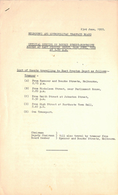
Document - List, Melbourne & Metropolitan Tramways Board (MMTB), "Official opening of Bourke Street - Northcote Routes at East Preston Depot 24th June 1955 at 3.00pm", 23/06/1955 12:00:00 AM
List - 7 foolscap sheets, duplicated, stapled in top left hand corner, titled "Official opening of Bourke Street - Northcote Routes at East Preston Depot 24th June 1955 at 3.00pm", listing the guests and the tram departure times along the route and those travelling on their own transport. Lists some 240 people overall. Lists their position or body representing for about half of the people. Dated 23/6/1955trams, tramways, east preston, bourke st, opening, new tramway -
 Melbourne Tram Museum
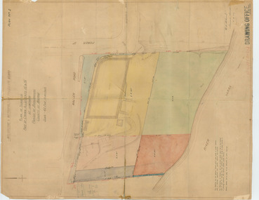
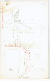
Drawing, "Plan of Survey of Part of Crown Allotments 15 and 16 at Hawthorn, Parish of Boroondara, County of Bourke", 1922
Drawing, coloured with water based drawing wash, titled "Plan of Survey of Part of Crown Allotments 15 and 16 at Hawthorn, Parish of Boroondara, County of Bourke". Shows the tram track, Wallen Road, changes around the intersection with Power St, buildings. A note at the bottom notes who owns what - MMTB and City of Hawthorn. Prepared by H. S. McComb, licensed Surveyor 6-9-1922. Stored folded.Stamped "Drawing Office" "Office Copy" and in red pencil "Hawthorn" in the bottom right hand corner, and on the rear "Drawing Office" "Office Copy" and "Hawthorn Depot" in pencil.trams, tramways, htt, mmtb, hawthorn depot, plans -
 Melbourne Tram Museum
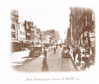
Photograph - Set of two Black & White Photograph/s, "Bourke St looking west from Swanston St, World War 1 era", 1980's?
Set of two reproduced photographs, sepia toned of "Bourke St looking west from Swanston St, World War 1 era", with Coles Book Arcade, Bull and Mouth Hotel, Kino's Merchants, Danks, The Metropole, Wertheim. The cable tram has the destination of Nicholson St. One of a series of four photographs produced by an unknown person/company. Two sizes of prints held, one large, two small.On the rear of 587 "Cable Tram prints $10/set"trams, tramways, melbourne, bourke st, cable trams -
 Melbourne Tram Museum
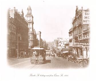
Photograph - Black & White Photograph/s, "Bourke St looking east from Queen St 1921", 1980's?
Reproduced photograph, sepia toned of "Bourke St looking east from Queen St 1921" with the Post Office, Myers, the Leviathan, and Parliament House in the distant background. Also a shop "Hatters Kenos Mercers" The cable tram has the destination of "Spencer St" One of a series of four photographs produced by an unknown person/company. Two small size prints held. See Reg Items 301 and 5274 for other copies.On the rear of 587 "Cable Tram prints $10/set"trams, tramways, melbourne, bourke st, cable trams, post office -
 Melbourne Tram Museum
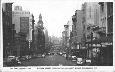
Postcard, Rose Stereograph Co, "Bourke Street looking to Parliament House, Melbourne", c1939
Rose Series postcard No. P 3589, titled "Bourke Street looking to Parliament House, Melbourne". The photo looks east from Queen Street. There are several cable trams in the view. Has signs for Gibson, the Victoria Hotel, Osram lamps and valves, BGE, Myer, Foys, Danks, Thomas Evans, Donald Macintosh gun maker, and the Evans House, The Commercial Bank of Australia. See item 8071 for a similar image.Yields information about Bourke St c1939.Postcard - printed real photograph with Rose Stereograph Co. name on the rear.trams, tramways, cable trams, bourke st -
 Melbourne Tram Museum
Document - Research Notes, H. S. McComb, Bourke St to Nicholson St line, Brunswick East line, c1930
Notes 10 pages, pinned together, giving details, opening dates, terminals, depot entries, sheave pits, curves, for the Bourke St to Nicholson St line, Brunswick East, including the connection into Spencer St. Includes 2 pages pinned together for the Gertrude, Smith St to Queens Parade line. Items 2064 to 2075 within box 72.3 in a brown folder marked "MT&O Co." red pencil on the front cover.trams, tramways, mto co, cable trams, drawings, reports, surveys, bourke st, nicholson st, gertrude st, smith st, queens parade -
 Melbourne Tram Museum
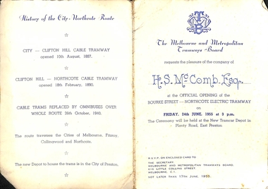
Ephemera - Invitation, Melbourne & Metropolitan Tramways Board (MMTB), "Official Opening of the Bourke Street - Northcote Electric Tramway", Jun. 1955
Printed invitation on off-white card with MMTB letter head invitation to the "Official Opening of the Bourke Street - Northcote Electric Tramway", Friday 24th June 1955 at 3pm at the new tramcar depot in Plenty Road Preston. Has been handwritten for "H. S. McComb Esq." in blue ink. Has a map of the route, the Nicholson St line show dotted and schedule for completion in 1956, details of the project and a brief history of the route.trams, tramways, opening, civic functions, bourke st, preston depot, northcote, cable trams -
 City of Melbourne Libraries
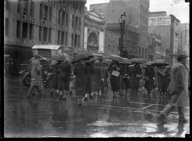
Photograph (series), Christmas shopping in the wind and rain, Bourke Street, Melbourne
SHOPPING CONTINUED AMID RAIN AND STORM IN THE CITY. Battling against the rain and wind, Christmas shoppers had an unpleasant time in Melbourne yesterday as they made their way from shop to shop; but still, they made their purchases, and with parcels and shopping bags clutched close, and with umbrellas held against the wind, they made their way to trains and trams for the homeward journey. A picture in Bourke-street yesterday. Photographer notations on slide: "Xmas shopping in wind and rain Age B9" Published: (1933, December 15). The Age (Melbourne, Vic. : 1854 - 1954), p. 13. Published title: SHOPPING CONTINUED AMID RAIN AND STORM IN THE CITY. Published caption: Battling against the rain and wind, Christmas shoppers had an unpleasant time in Melbourne yesterday as they made their way from shop to shop; but still, they made their purchases, and with parcels and shopping bags clutched close, and with umbrellas held against the wind, they made their way to trains and trams for the homeward journey. A picture in Bourke-street yesterday. Trove article identifier: http://nla.gov.au/nla.news-article203353770 Description: Crowd of men and women in winter clothing, in the rain, carrying umbrellas, crossing at the intersection of Bourke and Swanston streets. “Xmas shopping in wind and rain. When we first saw the rain, umbrellas, long coats and fox stoles, we naturally assumed this photo was taken in mid-winter. Some months later, we noticed the photographer’s pencil “scritchings” at the slide’s edge, and the truth was revealed: mid-December Melbourne in Bourke Street!" Research by project volunteers: Visible buildings include Leviathan Men's Clothing Store in Beaux Arts style, Melba Theatre and London Stores, together with signage for Public Benefit Footwear (later to become PBs). Leviathan was an Australian clothing brand established 1865, producing garments for sailing and watersports. Melba Theatre, opened in 1911, was a long narrow theatre of only 17 seats across. Adjacent to the Melba Theatre are a Woolworths and a Coles. The Public Bootery, a shoe shop established 1908, moved to this site 1924. Double headed decorative street lights (now called "Collins Street lights") were installed in 1929, inspired by the street lighting style of San Francisco. -
 Flagstaff Hill Maritime Museum and Village
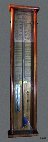
Barometer, 1858-1869
The barometer was either made or sold by T. Gaunt & Co. of Melbourne, a manufacturer, importer and retailer of a wide variety of goods including jewellery, clocks and watches, navigational and measuring instruments, dinnerware, glassware and ornaments. Thomas Gaunt photograph was included in an album of security identity portraits of members of the Victorian Court, Centennial International Exhibition, Melbourne, 1888. (See below for further details.) Admiral Fitzroy Pattern Barometer History: The stick mercury barometer was named after Admiral Robert Fitzroy of the Royal Navy (1805-1865) for his detailed instructions on how to interpret the weather, which were included with the instrument. Fitzroy was the captain of the HMS Beagle, also a weather forecaster to Charles Darwin and the second Governor of New Zealand. He developed many different types of barometers and was the first person to introduce the science of weather forecasting to the British Isles. A local manufacturer of scientific instruments, Thomas Gaunt, produced the barometer that was adapted for the southern hemisphere by Robert Ellery, the State Astronomer based at the Melbourne Observatory. In the original sale catalogue for Gaunt's, the item is described as "Gaunt's Fitzroy Barometers" and it was priced from 25/- to ₤9.9s. History of Thomas Gaunt: Thomas Gaunt established Melbourne's leading watchmaking, optical and jewellery business during the second half of the 19th century. Gaunt arrived in Melbourne in 1852, and by 1858 had established his own business at 14 Little Bourke Street. Around 1869 he moved to new premises in Bourke Street on the corner of Royal Arcade. Gaunt's shop quickly became a Melbourne institution. Gaunt proudly advertised that he was 'The only watch manufacturer in the Australian colonies'. While many watches and clocks may have had Gaunt's name on the dial, few would have been made locally. Gaunt did make some watches for exhibitions, and perhaps a few expensive watches for wealthy individuals. Gaunt's received a telegraph signal from Melbourne Observatory each day to correct his main clock and used this signal to rate and repair ship's chronometers and good quality watches. His main horological manufacturing was directed at turret clocks for town halls, churches and post offices. These tended to be specific commissions requiring individualised design and construction. He made the clock for the Melbourne Post Office lobby, to a design by Government Astronomer Robert Ellery, and won an award at the 1880-81 Melbourne International Exhibition for his turret clock for the Emerald Hill Town Hall. He became well known for his installation of a chronograph at Flemington Racecourse in 1876, which showed the time for the race, accurate to a quarter of a second. The firm also installed the clockwork and figures for Gog and Magog in the Royal Arcade. Thomas Gaunt also developed a department that focused on scientific instrumentation, making thermometers and barometers (from imported glass tubes), telescopes, surveying instruments and microscopes. Another department specialised in electroplating for trophies, awards and silverware, and the firm manufactured large amounts of ecclesiastical gold ware and silverware, for the church including St Patrick's Cathedral. There are no records that disclose the number of employees in the firm, but it was large enough for Gaunt to hold an annual picnic for the watchmakers and apprentices at Mordialloc from 1876; two years previously they had successfully lobbied Gaunt to win the eight hour day. Gaunt's workforce was reportedly very stable, with many workers remaining in the business for 15 to 30 years. Gaunt's wife Jane died on September 1894, aged 64. They had one son and six daughters, but only three daughters survived to adulthood. Two became nuns at the Abbotsford Convent and one daughter, Cecelia Mary Gaunt (died 28 July 1941), married William Stanislaus Spillane on 22 September 1886 and had a large family. Gaunt died at his home in Coburg, Victoria, leaving an estate valued at ₤41,453. The business continued as T. Gaunt & Co. after his death. The barometer is historically significant as an example of the work of Melbourne’s leading scientific instrument maker, Thomas Gaunt. The barometer has social significance as an example of the type of scientific equipment that Thomas Gaunt expanded his horology business into producing. Further social significance lies in the fact that Robert Ellery, the Government Astronomer who designed the local version of the barometer, had a direct connection with the Melbourne Athenaeum founded in 1839 as the Melbourne Mechanics' Institution. Its purpose was "the diffusion of literary, scientific and other useful information". There are also records of a T Gaunt as a subscription and committee member of this the Athenaeum organisation during the 1870s and 1880s which may be Thomas Gaunt, unfortunately still unverified.Stick mercury barometer known as the Admiral Fitzroy Barometer. It comprises an oblong wooden case with glass front panel, ornate pediment, barometer with bulb cistern (empty of fluid), cleaning brush with printed instructions for interpreting information given by the gauge affixed to left and right face of instrument. Includes a thermometer. The barometer appears to be intact. Adapted to the Southern Hemisphere. Special remarks by Admiral Fitzroy. Made by Thomas Gaunt, Melbourne. Manufacturer's details are on back of wooden casing. Rear has upper and lower brass screw plates for securing to vertical surface."Manufactured by Thomas Gaunt, 14 Little Bourke Street, Melbourne. "flagstaff hill, warrnambool, shipwrecked-coast, flagstaff-hill, flagstaff-hill-maritime-museum, maritime-museum, shipwreck-coast, flagstaff-hill-maritime-village, barometer, admiral fitzroy, thomas gaunt, thomas gaunt of melbourne, clockmaker, admiral fitzroy barometer, barometer instructions, gaunt’s fitzroy barometer, gaunt’s of melbourne, gog and magog designer, horological manufacturer, meteorological instrument, melbourne athenaeum, melbourne mechanics' institution, melbourne observatory time signal, robert ellery government astronomer, scientific instrument, stick mercury barometer, thermometer, weather forecast, t gaunt & co -
 Melbourne Tram Museum
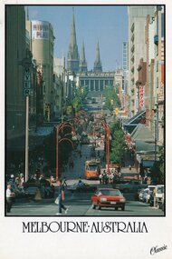
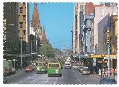
Postcard, Nu-color-Vue, Bourke St Mall from Queen St, late 1980's
Colour postcard divided back, white border, - Nu-Color-Vue, The Classic Collection of Bourke St Mall from Queen St looking east, with a number of trams in the view, including Parliament house. Has Myer, Midtown Plaza and a sign for Qantas. Back has space for name and address, stamp and a message and details of the postcard. Produced by Nu-Color-Vue, number 140 078 NCV 7027 Has "Melbourne Australia" along the bottom edge.trams, tramways, bourke st, parliament, mall, z class -
 Melbourne Tram Museum
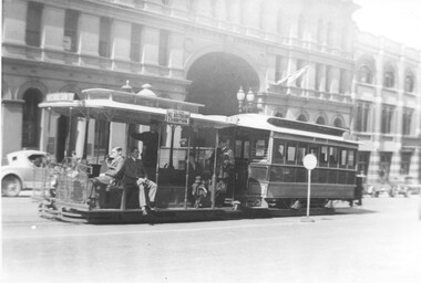
Photograph, Cable tram 534 in Bourke Street outside the St. James Building, 1924
The photograph shows a cable tram set with trailer No. 534 east bound in Bourke St on its way to Nicholson St passing the St. James Building at William Street. The conductor standing at the back of the grip car is in MMTB uniform with his ticket wallet in his left hand and bag visible. The grip man appears to be ringing his bell. There is a side advertisement for the "All Australian Exhibition". A reference to the exhibition is in The Argus of 3/11/1924 - see reference.Yields information cable trams in Bourke St and their crews.Photograph, black and white, plain backtrams, tramways, cable tram, bourke st, conductors, tram crews, william st, tram 534 -
 Kew Historical Society Inc
Map, Robert Russell, Map Shewing the Site of Melbourne and the Position of the Huts & Buildings Previous to the Foundation of the Township by Sir Richard Bourke in 1837
Map shows the first layout of Melbourne by Government surveyor Robert Russell, who accompanied Governor Richard Bourke in 1837. The surveyed blocks extend from present-day Flinders Street to Lonsdale Street, and Spring Street to Spencer Street, with extensive vacant land west to a salt lake (afterwards Batman's Swamp, later drained), north beyond Flagstaff Hill and south towards South Melbourne. Vegetation coverage is indicated, and tracks and existing buildings and cultivated land are shown.Printed map was created by Day & Haghe, Lithographers to the Queen, sometime after 1838, when the company received its Royal appointment. Copies of the 1837 map exist in several major map collections in Australia; most are uncoloured. This particular map is the earliest in the Kew Historical Society's map collection. It is a nationally significant artefact. Black and white lithographed map hand-coloured in blue and yellow gouache of the town of Melbourne in 1837. In contrast to the original lithograph, the river and the township blocks are coloured blue and yellow. A similar, partly coloured copy is in the collection of the University of Melbourne.maps - melbourne - 1830s, governor sir richard bourke, robert russell - surveyor, cartography -
 Melbourne Tram Museum
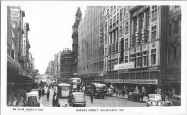
Postcard, Rose Stereograph Co, "Bourke Street Melbourne", early 1940s
Rose Series postcard No. P 1083, titled "Bourke Street Melbourne", showing a busy scene outside Buckley & Nunn Limited store and the Myer Emporium. In the view are two double-decker buses, two single-decker buses in the wartime livery with white mudguards and white rear panels. one horse-drawn cart is on the opposite of the road. There is a gas producer pack on the back of the car parked on the left-hand side of the photograph. Also in the view are signs for London Stores.Yields information about Bourke St early 1940s.Postcard - printed real photograph with Rose Stereograph Co. name on the rear.tramways, bourke st, buses, world war ii, td5c class, ts8c class, mmtb buses -
 Melbourne Tram Museum
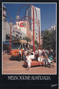
Postcard, Nu-color-Vue, Z110 in the Bourke St Mall, late 1980's
Colour postcard divided back, black border, - Nu-Color-Vue, The Classic Collection of Z110 in the Bourke St Mall, at the Swanston St tram stop, late 1980s. Has the Coles store in the background. Tram has the destination of Route 87, LaTrobe University. Back has space for name and address, stamp and a message and details of the postcard. Produced by Nu-Color-Vue, number 140 117, NCV 6340. Has "Melbourne Australia" along the bottom edge.trams, tramways, bourke st, route 87, mall, z class, tram 110 -
 Lara RSL Sub Branch
Photograph, John Leslie Shepherdson, W W 1
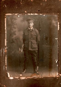
John Leslie Shepherdson joined as a private on 31st August 1914 from Tatura, Victoria. His father lived at Birregurra, Victoria. John's military number 857. Australia declared war on Germany on the 4th August. Wounded (shot in the head) landing on the beaches at Gallipoli, 25th April 1915, John recuperated in hospital and rejoined 7th Battalion 25th July 1915. Just in time for Lone Pine where he was wounded a second time 9th August 1915. While recovering was promoted to Sergeant and sent to 7th Battalion headquarters as part of 3rd Echelon B.E.F. This unit was reinforcements and returning wounded/sick who could not go back to active service due to wounds. He remained at headquarters as a clerk until the end of the war and was promoted to Lieutenant on recommendation of Secretary of State for valuable services rendered to Australia. John returned to Australia via America (at his own expense) in 1919. He left 7th Battalion Headquarters 26th October 1918.This picture is of national significance as it is a photo of a World War 1 Gallipoli veteran, wounded twice.Private John L Shepherdson of Birregurra- wounded at GallipoliYeoman & Co.....Bourke St.Melbourne .7th battalion, world war 1, ww1, gallipoli, lone pine, wounded -
 Ballarat Tramway Museum
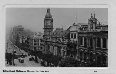
Postcard, GPC Depot Melbourne, Bourke St., looking north west
Glossy postcard with the edges raised above the photo of Bourke St., looking north west at southern face of town hall. Has cable trams and horse drawn vehicles in photo. Also has facade of 'Atheneum' Theatre. On base is title 'Collins Street Melbourne showing The Town Hall' and in RH corner 'No. 3' On rear are areas for Address and Correspondence. On rear side is Publisher details. Rear is finished in off-white card, while front has a light pink finish. Photo printed using a photographic paper.trams, tramways, melbourne, collins st., cable trams, melbourne town hall -
 Melbourne Tram Museum
Postcard, Biscay Greetings, Swanston St from near Bourke St, mid 1970's
Colour postcard divided back - Biscay Greetings, of an photo looking southwards along Swanston St from near Bourke St with trams 685 and 772 running routes 64 and 8 respectively. Has Ted's Camera store, The Sun, Batman books and Billy Guyatts stores signs in the photograph. Back has space for name and address, stamp and a message and details of the postcard. Produced by Biscay Greetings, possibly mid 1970's. Card No. BG 249 with a serrated edge. 2nd copy added 15/9/2020.trams, tramways, postcards, swanston st, w5 class, tram 685, tram 772 -
 University of Melbourne, Burnley Campus Archives
Newspaper - Newspaper Cutting, The South Bourke Standard, The Horticultural Society, 1864
Cop[y of article in "The South Bourke Standard" 29 July, 1864 p3. Description of the Annual Meeting of the Society. The December flood had destroyed the fruit tree plantings. The Government had refused a request to grant them more suitable land to the north so part of the ornamental section had to be broken up and planted with fruit trees.the south bourke standard, floods, ornamental garden broken up, fruit trees, fruit trees destroyed, refusal of government funding, government funding -
 City of Moorabbin Historical Society (Operating the Box Cottage Museum)
Document, laminated photocopy of 'Plan of Moorabbin 1850', 1853
Weston Bate, 'A history of Brighton' 1962 informs us that in 1840 Henry Dendy, who was a farmer in Sussex England, paid 5,120 pounds sterling @ 1pound per acre for a 'Special Survey of Land in Port Phillip , Australia. Henry arrived in Australia in 1841 on the frigate 'York' with his wife, son, and three servants. He also took advantage of the Government Assistance of Free Immigrants for Survey Purchasers, to help on his estate and persuaded some Sussex men with their families to follow him. However when Dendy arrived in Port Phillip he found that LaTrobe and Gipps were trying to raise the price of land close to Town to 15pounds per acre. Dendy asked merchant J.B.Were to manage his affairs and they went ahead with plans to subdivide the surveyed land called 'The Brighton Estate' This area of land extended easterly from the Port Phillip Bay to East Boundary Road and from North Road to South Road in the Parish of Bourke Victoria. The Privy Council, England , decide that Henry Dendy could purchase the land at 1pound per acre. Land Sales proceeded from 1844 as more immigrants established market gardens, farms and varied businesses in 'Moorabbin'This is a photocopy of a Map of the Moorabbin , County of Bourke c1850 showing the 'Henry Dendy Special Survey 1841'A photocopy of a Map of the Moorabbin , County of Bourke c1850. A3 size laminatedLeft corner : MOORABBIN / COUNTY OF / BOURKEdendy henry, dendy special survey 1841, brighton, moorabbin, ormond, bentleigh, market gardeners, pioneers early settlers, box william, box elizabeth -
 Melbourne Tram Museum
Document - Memorandum, Melbourne & Metropolitan Tramways Board (MMTB), "Memo to Members of the Board - The Bourke Street - Nicholson Street and Clifton Hill and Northcote Conversion", 13/10/1938 12:00:00 AM
Memorandum, typed foolscap, 8 sheets, titled "Memo to Members of the Board - The Bourke Street - Nicholson Street and Clifton Hill and Northcote Conversion" dated 13/10/1938. The report looks at major English cities, excluding London, transport to developing housing areas outside existing transport links, costs of conversion compared to buses, success of diesel buses (referred to as crude oil buses), construction of new tram lines, use of trolley buses and tables looking at the cost and revenues for each routes, comparison of service levels, capital costs and other factors. Recommends that the Collingwood cable line be closed as soon as practicable. See also Reg Item 934 for a bound copy of his full overseas tour report.trams, tramways, mmtb, bourke st, conversion, double deck buses, tours, overseas tours, buses, trolley buses, uk, costs, housing -
 National Wool Museum
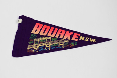
Pennant
BOURKE NSW (in pink and white) BOURKE NSW (in yellow and white)bourke, new south wales -
 Melbourne Tram Museum
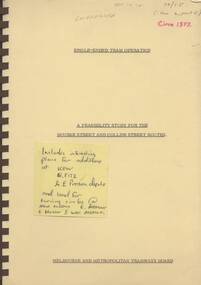
Document - Report, Melbourne & Metropolitan Tramways Board (MMTB), "Single-ended tram operations - A Feasibility study for the Bourke St and Collins Street routes", mid 1970's
Sixty five page, plus manila covers, bound with a brown coloured comb binder report titled "Single-ended tram operations - A Feasibility study for the Bourke St and Collins Street routes". Looks at the background for the proposal, operational issues and an economic evaluation, including loading and unloading, a CBD loop and capital costs. Report has a note on page 2 that it was prepared prior to tendering for new trams. Report not dated as such but on front cover has a date "c1977", though based on the note done prior to ordering new trams could be c1976. See also Reg Item 338. On front cover is a post-it notes commenting about report - see image. See Reg Item 4388 for the contract tender document for the Z3 class trams which included the option for a single ended tram.Various pencil notes on front cover, and inside page.trams, tramways, single ended tramcars, mmtb, bourke st, collins st, turning loops -
 Melbourne Tram Museum
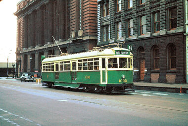
Photograph - Digital Image, W6 1000 on the opening day of the service in Bourke St, 26/06/1955 12:00:00 AM
Set of 4 digital images of W6 1000 on the opening day of the service in Bourke St via High St Northcote to East Preston on 26/6/1955. .1 - 1000 (East Preston route 89) at Spencer St, note the sign behind the tram and the newly painted safety zone. Has the Mail Exchange in the background. .2 - ditto at Spencer St with Carlyon's Hotel and the Spencer St Railway station in the background. .3 - tram arriving at the East Preston depot leads - has adverts for Milo, Kiwi boot polish and Pleshur's shoes. .4 - ditto with a Book Repairs Shop, R. P Evans, Goweville Hotel advertising Fosters Lager, and the Melody Picture theatre, In the background is Bell St with a set of clock traffic lights and two tower wagons and a Pura Milk truck just behind the tram.trams, tramways, w6 class, opening, route 89, bourke st, east preston, high st, northcote, tower trucks, traffic lights, bell st, tram 1000 -
 Ballarat Heritage Services
Photograph - Photograph - Colour, Stewart and Co Photograph
Two studio photographs by Stewart and Co or 217 -219 Bourke Street, Melbourne. One is of a man, the other is of a woman. stewart and co., photographers, studio portrait, women, men -
 Whitehorse Historical Society Inc.
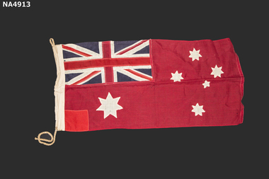
Flag - Flag Red Ensign -small
Belonged to Mr. W Hawkins who founded the Carry On Club in 1932. A group of returned servicemen nd business men of Melbourne . The aim of the club was to assist many World War I veterans who were experiencing hard times after the economic collapse of 1929Australian Red Ensign. Upper left on Hoist side Red Cross over-sewn over-sewn on White cross over-sewn on Navy blue background. Commonwealth(Federal) star lower Left on hoist side white 7 points Southern cross four stars white 7 points, one white star small 5 points. Red square patch : lower left on hoist side Cord Loop top left on hoist side. Cord bottom left on hoist sideThomas Evans Pty Ltd 415 Bourke Street Melbourneflags, national -
Whitehorse Historical Society Inc.
Article, Ballyshanassy
Paragraph about Ballyshanassy (County of Bourke) in the Victorian GazetteerParagraph about Ballyshanassy (County of Bourke) in the Victorian GazetteerParagraph about Ballyshanassy (County of Bourke) in the Victorian Gazetteerballyshanassy shire of nunawading, bourke -
 City of Moorabbin Historical Society (Operating the Box Cottage Museum)
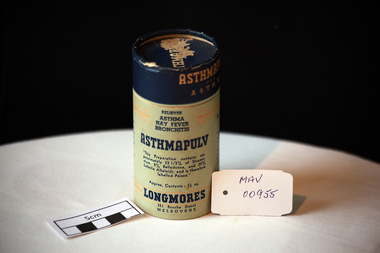
Containers, cardboard, ‘Longmores’ ‘Asthmapulv’, mid 20thC
Longmore’s was a manufacturing chemical pharmacy of many over-the-counter preparations, including Sulphur Hair Restorer, Strengthening Tonic, Blood and Liver Pills, Asthmacur (for asthma) and Hoyle’s Miraculous Oil (for miracles unknown), He was a native of New South Wales, but his father, Mr. Joseph Longmore settled in Melbourne in the late 1850s. Mr Longmore was educated at the Melbourne Grammar School, and leaving early, he studied and qualified as a chemist. Argus “12 October 1921, Mr. Francis Longmore, chemist of Bourke Street was at his business on Saturday but he had a chill which developed into pneumonia, and he died yesterday morning. The funeral will leave from his residence Wontravell, Gower Street, Kensington. He was a widower, his wife having died a year ago and he leaves a grownup family of 2 sons and 6 daughters. Carlisle Francis Longmore and his certificate number as a pharmacist was No. 1440; he qualified as a pharmacist at his final exam in Victoria on 11 September 1905. He had three pharmacies in addition to the address on the covers, one on the corner of Flinders and King Streets, Melbourne, one at 130 Bourke Street East and one Brunswick Street, North Fitzroy. He also had another sideline in addition to his pharmaceuticals and this was White Crow Jelly Crystals made at his Food Products division in Melbourne A cardboard cylindrical container with a lift-off lid for 'Longmores Asthmapulv'.Lid ASTHMAPULV. Around Lid ASTHMAPULV /FOR / ASTHMA Relieves/ ASTHMA / HAY FEVER / BRONCHITIS / ASTHMAPULV / "This preparation contains......... labelled Poison" / Approx. Contents 3 1/2 oz. / LONGMORES / 361 Bourke Street / MELBOURNE / For Inhalation Only / DIRECTIONS ................ / Invaluable in severe cases of Asthma. ......... / (Patent Medicine) Act 1942........* pharmacy, medicines, longmore c.. francis, longmore joseph, asthma, hospitals, nursing, containers, moorabbin, bentleigh, cheltenham, melbourne -
 Ithacan Historical Society
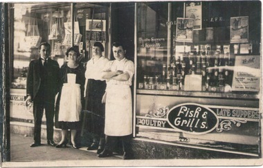
Photograph, The Golden Age Cafe
The photograph is of the Golden Age Café which was opened during the the First World War by Peter and Dennis Flocas. It was situated at the top end of Bourke Street near Spring Street.This would have been one of the earlier businesses which Ithacans owned in the Melbourne CBD. Many more Ithacans ran food vending businesses in the subsequent years.A scanned sepia photograph of two ladies and two men standing outside a fish and grill cafe. -
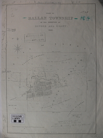 Ballan Shire Historical Society
Map - Map. Ballan Township, Plan of Ballan Township in the Counties of Bourke and Grant
The map is an early one of the township of Ballan showing street names and land owners.The map is significant in that it lists the owners of the house blocks within the township.A map showing the township and surrounding area of Ballan in 1856. Town streets are named as are the owners of the subdivided blocks of land. The map is a lithocopy and there is a scale in chains."D D Fraser" is written across the top of the map and "1856" is written in the near top right corner. There are other additions to the map but they are very difficult to decipher accurately or completely.ballan, ballan township map, ballan1856