Showing 214 items
matching murray bridge
-
 Eltham District Historical Society Inc
Photograph, Edendale Farm, Eltham Heritage Tour, 24 May 1992, 24/05/1992
ELTHAM HERITAGE TOUR The Society excursion on 24th May 1992 was arranged by David Bick, leader of the team carrying out the Shire's heritage study. David selected a number of sites or buildings identified in the study, some of them lesser known components of the Shire's heritage. The tour commenced at the Eltham Shire Office at 10.00 am. Travel was by private car and mini-bus with stops at about twelve locations for commentary by David.It included a short walk in Hurstbridge and lunch at Kinglake. Highlights of the tour included: - 10 am Leave from Shire Offices - 3 Important Trees - A Physical Link to Eltham's First Settlers - Toorak Mansion Gates - A Surviving Farm House - An Intact Circa 1900 Main Street - First Settlers - Gold Miners, and Timber-getters - An Early Hotel - A Pioneering Homestead - Changing Eltham Shire - 20th Century - 4 pm Afternoon Tea and Finish Tour Extract from ELTHAM CULTURAL HERITAGE TOUR (Newsletter No. 85, July 1992, by Bettina Woodburn) "The land was unprofitable for intensive farming, but there was always water in the Diamond Creek. The railway, a technological advance, followed the valley, and was provided to transport produce. At North Eltham we were privileged to tour a surviving farmhouse of the 1860-70 era at the Shire’s Edendale Farm, with the as yet unfinished Sculpture for a front fence - bulbous tree-trunks decorated with salt pots, with cross members from the old trestle bridge. As was usual these six veranda posted houses faced South (or East, away from the sun!) with the scullery, kitchen and pantry "out the back". The veranda, which must have been very narrow, no longer exists. It probably wrapped around three sides. The drive took us past the Dutch Windmill, only twenty years old and in the Shire of Diamond Valley, then the Diamond Creek Cemetery with impressive gateway, to a detour to see another old farmhouse, isolated on a hill off Murray Road Wattle Glen. Here was a particularly thick patch of exotic planting of pines and cypresses. Subsistence farming no longer pays. Following the rail-line we noticed on the left near Silvan Road an Edwardian cottage and on the right near Yates Road the old school residence for this Upper Diamond Creek area."Record of the Society's history and activities and highlighting various aspects of the Heritage Study undertaken by David Bick used to create the future heritage overlay for the Shire of Eltham and later Nillumbik Shire.Roll of 35mm colour negative film, 4 stripsKodak Gold 100 5095eltham, shire of eltham historical society, activities, heritage tour -
 Eltham District Historical Society Inc
Negative - Photograph, Tom Prior, Langlands Bridge, Eltham, c.1900
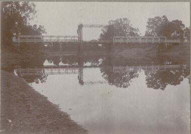
It is noted in the Reynolds Prior collection (Ivy Reynolds) as the first bridge in Eltham however given the current state of knowledge, this is considered unlikely and there is no other supporting source. John Hunter Langlands, owner of the farm known as ‘Ihurst’ on the west side of Diamond Creek to the south of John Wright Murray’s land, died in 1907. In 1909 his land was subdivided into 100 lots to become the ‘Glen Park Estate’. It is possible that the bidge may have crossed the Diamond Creek to Langland's land along the original alignment of Glen Park Road which used to run between present day Progress Road and Coleman Crescent. SEPP Source (c.1970): Mrs. E.R. Reynolds, Thompson Crescent, Research The Reynolds family were early settlers in Research. The Reynolds/ Prior collection of photographs were taken by Tom Prior, the maternal uncle of Ivy Reynolds, around 1900 and the 60 photos in the album give a fine overview of many of the landmarks of Research and Eltham over 100 years ago. lvy lived in the family home for many years at 106 Thompson Cres Research. Ivy's father, Ernst Richard Reynolds and grandfather, Richard Reynolds, lived at the same address. Ivy's father Richard worked for Mr. Trail on his property in Research. Reynolds Road is named after the family. Mr Tom Prior (wife Eva) worked at the Melbourne zoo. He was very innovative and made his own camera, using the black cloth hood to exclude the light. The photographs are a reminder of the rural nature of Research and Eltham and its rich heritage. This photo forms part of a collection of photographs gathered by the Shire of Eltham for their centenary project book,"Pioneers and Painters: 100 years of the Shire of Eltham" by Alan Marshall (1971). The collection of over 500 images is held in partnership between Eltham District Historical Society and Yarra Plenty Regional Library (Eltham Library) and is now formally known as the 'The Shire of Eltham Pioneers Photograph Collection.' It is significant in being the first community sourced collection representing the places and people of the Shire's first one hundred years.Digital image 4 x 5 inch B&W Neg B&W printsepp, shire of eltham pioneers photograph collection, eltham, langlands bridge, reynolds prior collection, bridge, john hunter langlands -
 Eltham District Historical Society Inc
Photograph, Edendale Farm, Eltham Heritage Tour, 24 May 1992, 24/05/1992
ELTHAM HERITAGE TOUR The Society excursion on 24th May 1992 was arranged by David Bick, leader of the team carrying out the Shire's heritage study. David selected a number of sites or buildings identified in the study, some of them lesser known components of the Shire's heritage. The tour commenced at the Eltham Shire Office at 10.00 am. Travel was by private car and mini-bus with stops at about twelve locations for commentary by David.It included a short walk in Hurstbridge and lunch at Kinglake. Highlights of the tour included: - 10 am Leave from Shire Offices - 3 Important Trees - A Physical Link to Eltham's First Settlers - Toorak Mansion Gates - A Surviving Farm House - An Intact Circa 1900 Main Street - First Settlers - Gold Miners, and Timber-getters - An Early Hotel - A Pioneering Homestead - Changing Eltham Shire - 20th Century - 4 pm Afternoon Tea and Finish Tour Extract from ELTHAM CULTURAL HERITAGE TOUR (Newsletter No. 85, July 1992, by Bettina Woodburn) "The land was unprofitable for intensive farming, but there was always water in the Diamond Creek. The railway, a technological advance, followed the valley, and was provided to transport produce. At North Eltham we were privileged to tour a surviving farmhouse of the 1860-70 era at the Shire’s Edendale Farm, with the as yet unfinished Sculpture for a front fence - bulbous tree-trunks decorated with salt pots, with cross members from the old trestle bridge. As was usual these six veranda posted houses faced South (or East, away from the sun!) with the scullery, kitchen and pantry "out the back". The veranda, which must have been very narrow, no longer exists. It probably wrapped around three sides. The drive took us past the Dutch Windmill, only twenty years old and in the Shire of Diamond Valley, then the Diamond Creek Cemetery with impressive gateway, to a detour to see another old farmhouse, isolated on a hill off Murray Road Wattle Glen. Here was a particularly thick patch of exotic planting of pines and cypresses. Subsistence farming no longer pays. Following the rail-line we noticed on the left near Silvan Road an Edwardian cottage and on the right near Yates Road the old school residence for this Upper Diamond Creek area."Record of the Society's history and activities and highlighting various aspects of the Heritage Study undertaken by David Bick used to create the future heritage overlay for the Shire of Eltham and later Nillumbik Shire.Roll of 35mm colour negative film, 4 stripsKodak Gold 100 5095eltham, shire of eltham historical society, activities, heritage tour -
 Eltham District Historical Society Inc
Photograph, Edendale Farm, Eltham Heritage Tour, 24 May 1992, 24/05/1992
ELTHAM HERITAGE TOUR The Society excursion on 24th May 1992 was arranged by David Bick, leader of the team carrying out the Shire's heritage study. David selected a number of sites or buildings identified in the study, some of them lesser known components of the Shire's heritage. The tour commenced at the Eltham Shire Office at 10.00 am. Travel was by private car and mini-bus with stops at about twelve locations for commentary by David. It included a short walk in Hurstbridge and lunch at Kinglake. Highlights of the tour included: - 10 am Leave from Shire Offices - 3 Important Trees - A Physical Link to Eltham's First Settlers - Toorak Mansion Gates - A Surviving Farm House - An Intact Circa 1900 Main Street - First Settlers - Gold Miners, and Timber-getters - An Early Hotel - A Pioneering Homestead - Changing Eltham Shire - 20th Century - 4 pm Afternoon Tea and Finish Tour. Extract from ELTHAM CULTURAL HERITAGE TOUR (Newsletter No. 85, July 1992, by Bettina Woodburn) "The land was unprofitable for intensive farming, but there was always water in the Diamond Creek. The railway, a technological advance, followed the valley, and was provided to transport produce. At North Eltham we were privileged to tour a surviving farmhouse of the 1860-70 era at the Shire’s Edendale Farm, with the as yet unfinished Sculpture for a front fence - bulbous tree-trunks decorated with salt pots, with cross members from the old trestle bridge. As was usual these six veranda posted houses faced South (or East, away from the sun!) with the scullery, kitchen and pantry "out the back". The veranda, which must have been very narrow, no longer exists. It probably wrapped around three sides. The drive took us past the Dutch Windmill, only twenty years old and in the Shire of Diamond Valley, then the Diamond Creek Cemetery with impressive gateway, to a detour to see another old farmhouse, isolated on a hill off Murray Road Wattle Glen. Here was a particularly thick patch of exotic planting of pines and cypresses. Subsistence farming no longer pays. Following the rail-line we noticed on the left near Silvan Road an Edwardian cottage and on the right near Yates Road the old school residence for this Upper Diamond Creek area."Colour photograph1992, culture, edendale, edendale community farm, events -
 Orbost & District Historical Society
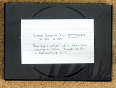
digital recording, Richard Rudolph Kreymborg, 2015
This recording was originally made C1970's-1980's at a service club meeting in Orbost. It was transferred from a tape recording in 2015. Rudy was the son of George James KREYMBORG and Ada Victoria (nee DAVIS). Born at Bulumwaal, near Bairnsdale he arrived in Orbost after time in Melbourne and then at the Bell Bird Hotel where his family had the mail run. In Orbost Rudy lived on the back of his his truck next to the present Murray Goulburn Store in „B‟ Road, Orbost with tw horses for company. (More info. from newsletter "RICHARD RUDOLPH KREYMBORG 1904-1987" by John Phillips.) Richard Rudolph “Rudy” KREYMBORG was a well-known district identity, a man who was often described as a legend in his lifetime. He lived a rough life, breaking horses, delivering mail on horseback, building roads and bridges, driving bulldozers and talking.A disc in a black plastic case. It is a recording of Richard Rudolph Kreynborg(b.1904 d.1987). It has been copied from a n original recording. -
 Marysville & District Historical Society
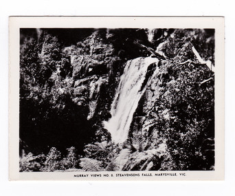
Photograph (item) - Black and white photograph, Murray Views, Murray Views No. 8. Steavensons Falls, Maryville, Vic, Post 1929
An early black and white photograph of Steavenson Falls, Marysville, Victoria.An early black and white photograph of Steavenson Falls, Marysville, Victoria. The Steavenson Falls is named after the Victorian Assistant Commissioner of Roads and Bridges, John Steavenson who arrived here in the early 1860s. This photograph was published by Murray Views in Gympie, Queensland, as a souvenir of Marysville.steavensons falls, steavenson falls, marysville, victoria, waterfall, murray views, photograph, souvenir, john steavenson -
 Marysville & District Historical Society
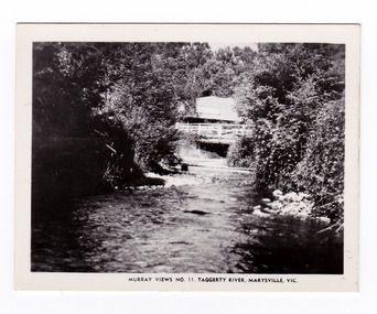
Photograph (item) - Black and white photograph, Murray Views, Murray Views No. 11. Taggerty River, Marysville, Vic, Post 1929
An early black and white photograph of the Steavenson River in Marysville, Victoria.An early black and white photograph of the Steavenson River in Marysville, Victoria. The Steavenson Falls is named after the Victorian Assistant Commissioner of Roads and Bridges, John Steavenson who arrived here in the early 1860s. This photograph was published by Murray Views in Gympie, Queensland, as a souvenir of Marysville.marysville, victoria, photograph, murray views, souvenir, steavenson river, john steavenson -
 Marysville & District Historical Society
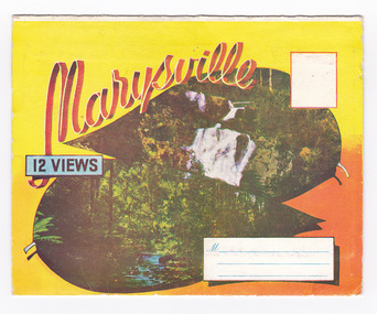
Postcard (item) - Colour photographs, Murray Views, Marysville 12 Views, 1950's
A fold out postcard of 12 colour photographs of scenes and landscapes in and around Marysville in Victoria.A fold out postcard 12 colour photographs of scenes and landscapes in and around Marysville in Victoria. These photographs were produced by Murray Views in Gympie, Queensland as a souvenir of Marysville.Marysville/ 12 VIEWS PRODUCED BY MURRAY VIEWS./ GYMPIE./ Q COPYRIGHT SAMUEL LEE & CO., PRINTERS. STEAVENSON'S FALLS, MARYSVILLE, VIC. TOURISTS AT MARYSVILLE, VIC. "FRUIT SALAD FARM", MARYSVILLE MAIN STREET, MARYSVILLE, VIC. ROAD SCENE, MARYSVILLE, VIC. THE CROSSWAYS, MARYSVILLE, VIC ROAD TO CUMBERLAND VALLEY, MARYSVILLE PANORAMA FROM BLACK SPUR, MARYSVILLE ROAD, MARYSVILLE, VIC. NICHOLL'S LOOKOUT, MARYSVILLE, VIC. TREE FERNS, MARYSVILLE, VIC. THE BRIDGE, MARYSVILLE, VIC.steavenson falls (image 1), tourists in marysville (image 2), taggerty river (image 3), fruit salad farm (image 4), main street marysville (image 5), road scene marysville (image 6), the crossways (image 7), cumberland valley (image 8), black spur (image 9), nicholl's lookout (image 10), tree ferns (image 11), bridge (image 12), marysville, victoria, postcard, souvenir, murray views -
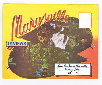 Marysville & District Historical Society
Postcard (item) - Colour photographs, Murray Views, Marysville 12 Views, 1950's
A fold out postcard of 12 colour photographs of scenes and landscapes in and around Marysville in Victoria.A fold out postcard 12 colour photographs of scenes and landscapes in and around Marysville in Victoria. These photographs were produced by Murray Views in Gympie, Queensland as a souvenir of Marysville.Marysville/ 12 VIEWS from Mrs Mary Keneally/ Marysville/ 28.11.91 PRODUCED BY MURRAY VIEWS./ GYMPIE./ Q COPYRIGHT SAMUEL LEE & CO., PRINTERS. STEAVENSON'S FALLS, MARYSVILLE, VIC. TOURISTS AT MARYSVILLE, VIC. "FRUIT SALAD FARM", MARYSVILLE MAIN STREET, MARYSVILLE, VIC. ROAD SCENE, MARYSVILLE, VIC. THE CROSSWAYS, MARYSVILLE, VIC ROAD TO CUMBERLAND VALLEY, MARYSVILLE PANORAMA FROM BLACK SPUR, MARYSVILLE ROAD, MARYSVILLE, VIC. NICHOLL'S LOOKOUT, MARYSVILLE, VIC. TREE FERNS, MARYSVILLE, VIC. THE BRIDGE, MARYSVILLE, VIC.steavenson falls (image 1), tourists in marysville (image 2), taggerty river (image 3), fruit salad farm (image 4), main street marysville (image 5), road scene marysville (image 6), the crossways (image 7), cumberland valley (image 8), black spur (image 9), nicholl's lookout (image 10), tree ferns (image 11), bridge (image 12), marysville, victoria, postcard, souvenir, murray views -
 Glen Eira Historical Society
Article - Rosstown Railway
This file contains three items: 1/A review of the ROSSTOWN RAIL TRAIL from LIVING IN GLEN EIRA, vol. 11, 2004, Issue 4, no. 25, date and author unknown. The review explains the purpose of the Rail Trail with a brief narrative of the history behind Rosstown Sugar Mill Railway line. Concluding with information on the location of the Trail and the expected time required to walk the entire track included in the review is a map of the Rail Trail, which marks significant sites along the trail with historic pictures. 2/A newspaper article from THE AGE, dated Tuesday 21/10/1980 and written by Iola Matthews, reporting on the circumstances that led to the publication of the book RETURN TO ROSSTOWN written by Des Jowett and Ian Weickhardt. The article begins with a brief biography of the authors before moving into details of the book’s content, providing a further biography of W. Murray Ross which includes information on his financial ventures – particularly the Rosstown Rail – his marriage and children. The article includes a black and white photograph of Weickhardt and Jowett walking along the route of the railway line, an illustration of the Rosstown sugar works and a map of the area surrounding the site of the mill. 3/Three photocopies of a black and white illustration of the Rosstown sugar works from the east, undated and artist unknown.rosstown rail trail, rosstown, ross william, ross w. murray, ross murray, sugar beet mills, mills, elsternwick, land transport, railways, railway lines, railway routes, carnegie neville street, carnegie miller street, factories, market gardens, horticulture, peat, soils, land forms, topography, geology, civic issues, cone sugar industry, elsternwick plaza, elsternwick, glenhuntly road, parks and reserves, ee gunn reserve, caulfield racecourse, sportsgrounds, caulfield, carnegie, riddell parade, clarence street, aileen avenue, princes park, dover street, marara road, oakleigh road, rosanna street, murrumbeena crescent, north road, kooyong road, hawthorn road, booran road, koornang road, poath road, warragul road, railway platforms, railway buildings, bambra road, swamps, landforms, landfill, council landfill, railway bridges, bridges, railway underpasses, sporting clubs, tennis clubs, bowls clubs, rosstown railway, rosanna street reserve, maps, railway maps, living in glen eira, weickhardt ian, jowett des, caulfield south, curraweena road, oakleigh, caulfield technical school, return to rosstown, beet sugar industry, crops, land booms, land development and subdivisions, bent thomas, fink benjamin, sugar works, rosstown hotel, oamdenong road, rosstown dry cleaners, shops, rosstown road, rosstown plate, people by circumstance, migrants, accountants, occupations, professionals, the grange, real estate, grange road, financial agents, judges, rosstown estate, financial trouble, rabbit preserving, breweries, political debates, political issues, political electorates, politics, political science, debt, financial loans, court procedures, court cases, legal events and activities, malleson and riggall, widowers, seabeach railway, economics, economic deadline, depression 1890s, economic crash, mortgages, divorce, social problems, poverty, ross claude, ross roderick, world war 1914-1918, wars, military history, servicemen, australian flying corps, engineers, caulfield council, swagmen, homelessness, glenhuntly road, glenhuntly road tram, woornack road, leila road, wild cherry road, melten avenue, illustrations, steam trains, trains, horse and cart, horse-drawn transport, railway stations -
Glen Eira Historical Society
Document - GLEN HUNTLY (HISTORY OF)
This file contains one item: 1/A loose-leaf, 23-page document titled ‘The History of Glen Huntly’, by Alfred R. Jones, dated 20/06/1991, describing the history of the suburb. The author has drawn heavily from the 4 sources noted in the bibliography. Subjects covered include the ship the suburb is named after, the suburb’s State School, the suburb’s churches, the Rosstown Railway and Sugar Mill, the origin of the name of Carnegie, the suburb’s aerodrome, and the beautification of the Glen Huntly Shopping Centre. The final 12 pages consist of 9 appendices relating to the aforementioned subjects. Appendix A is a typewritten letter from Ron McLeod, secretary of the Place Names Committee, to Mr. D. R. Aylen, CEO of the City of Caulfield, notifying the latter of the alteration of the name ‘Glenhuntly’ to ‘Glen Huntly’. Appendix B is a list of the ministers of St. David’s Uniting Church from its formation in 1916 to the present. Appendix C identifies the persons portrayed in St. David’s stained glass windows. Appendix D is a poster announcing the auction of 41 blocks of land between Hawthorn and Bambra Road formerly owned by William Ross, plus a map identifying said land blocks and anither fir locality. Appendix E is an A4 plan of the Rosstown Railway. Appendix F is a drawing of the Rosstown Sugar Mill. Appendix G is a poem titled ‘The Swagman’s Retreat’, by Herb Arnott, about the failure of the Mill. Appendix H is a map of Caulfield’s horse tramways plus a list of opening and closing dates. Appendix J is a list of streets explaining the meanings of their names.glen huntly, glenhuntly, local history, ‘glen huntly’ (ship), ‘glen huntlely’ (ship), quarantine stations, glen huntly road, lake street, mernda avenue, glen huntly state school no. 3703, ormond francis, ormond, garden avenue, grange road, churches, congregational church, glen huntly presbyterian church, st. david’s, st. david’s uniting church, anglican church, jenkin william ‘boss’, methodist church, wattle avenue, smith a. w. mr., glen huntly post office, glen huntly road, king f. l. mr., uniting church, child care centre, presbyterian church of eastern australia, glen huntly methodist church, sun aria, miller mary, stained glass, phrenologists, trinity congregational church, primitive methodists, ‘the victorian independent’, mercy mr., greek orthodox original old calendar church, wanalta road, salvation army, halls, myrtle street, catholic church, st. anthony’s roman catholic church, foundation stones, neerim road, mannix archbishop, st. agnes’ anglican church, booran road, sunday schools, clergy residences, ‘see’ anglican news magazine, lees archbishop, booth archbishop, glen huntly presbyterian church, el nido grove, tennis courts, bollard v. w. right rev., waratah avenue, royal avenue, munster avenue, james street, rothschild street, peace memorial organ, singers, bremner marie, scotland betty, carden joan, rosstown railway, south caulfield, plants, marata road, curraweena road, bambra road, ross william murray, ross leila, ross constance, vautin constance, ‘the grange’, north road, leila road, wild cherry road, caulfield roads board, elsternwick, land sales, sugar mills, koornang road, woornack road, elsternwick railway station, riddell parade, clarence street, dover street, oakleigh road, murrumbeena crescent, carlisle crescent, railways, trains, parks and reserves, caulfield council, sussex street, caulfield city council, swamps, rosstown sugar mill, rosstown estate, ‘the swagman’s retreat’, arnott herb, rosstown, carnegie, ‘ross’s folly’, carnegie andrew, rosstown hotel, dandenong road, rosstown road, rosstown plate horse race, caulfield racecourses, ames avenue, rosstown court, hostels, murrumbeena, cinemas, innovations (cabinetry film), films, music, pianos, manchester grove, safeway store, squash courts, airports, lord reserve, aeroplanes, air navigation act 1921, neville street, larkin sopwith aviation company of australasia, lyons street, morgan street, bookmakers, nightsoil, poultry, weatherboard buildings, glen huntly railway station, rosedale avenue, rifle clubs, scout groups, 1st glen huntly troop, ana, dowding jack mr., glen huntly infant welfare and family planning clinic, vermador private hospital, watson grove, rowlands (drapers), bones plant nursery, caulfield railway station, bridges, trams, horse tramways, glen eira road, elsternwick railway station, kooyong road, aboriginal peoples, truganini road, hannan lyn mrs. (urban planning officer), glen huntly shopping centre, sculptures, street beautification scheme, “flying the yellow flag”, moore olive, “return to rosstown”, jowett d. f., weickhardt i. s., “from sand swamp and health”, murray peter r., wells john c., caulfield historical society, newsletters, place names committee, mcleod ron, aylen d. r. mr., jones hugh rev., king joseph, scarfe james, vertigan sidney, vertigan earle, rance victor, flavell cameron, denholm robin, moorhead ken, taliai siupeli, eccles james leslie, little agnes, hutchins william r., dickie may a., gordon ivey agnes, theobald a. a. mrs., brownbill lloyd norman, ash georgette, land sales, auctions, messrs. crews & arkle, street names -
Federation University Historical Collection
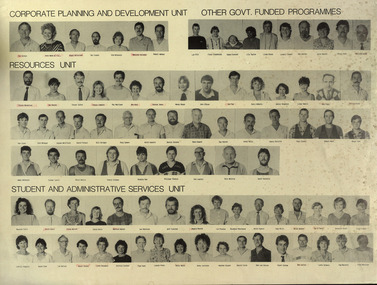
Poster, Ballarat School of Mines Staff Photos, c1988
Laminated black and white photographic portraits of Ballarat School of Mines staff members.xballarat school of mines, ian aitken, anne wood, roger macfarlane, des cooper, malcolm vallance, mal vallance, lyn pitt, floss stephenson, shane everard, lily saylor, linda bland, lyndall cooper, don doulton, julie baulch, peter gunn, malcolm gaunt, steven medelson, jan reeves, trevor slater, tracey cummins, ray martland, ann kerr, kieran jones, mandy rhook, john gibson, iam pym, patti mcnulty, janice shepherd, lindy hamill, bob feary, philip dixon, ron lucas, glen mcgregor, gordon whitefield, david fithall, bill bridges, doug symons, keith howlett, bernie stevens, norm howard, ray barnes, peter kelly, garry christie, paul clarke, robert munt, shaun tope, james mddonald, graeme tyrell, bruce wallis, tracey coleman, bradley rae, phillippe theatre, don lawless, bill whittle, geoff nicholls, maureen carli, keith boast, fiona watson, sonia davis, manfred hacker, ian robinson, jeff fletcher, angela murray, angela smith, lyn peucker, rosemary moorhouse, keith hankin, judy mills, brian webber, jan o'toole, veronica black, fleur haller, lorelli huggins, karen cook, len wilson, bruce staley, lynne beaumont, dzintra crocker, faye hunt, leonie hines, sally smith, jenny leviston, heather durant, barrie firth, john van dreven grant curnow, ron sutton, lynne schepis, pam merrett, fran harrison -
 Federation University Historical Collection
Poster, Ballarat School of Mines staff, 1995, 1995
Poster of all Ballarat School of Mines staff (named)davis, sonia, dixon, heather, dixon, philip, durant, heather, dyer, robert, fennell, anne, firth, barrie, gaunt malcolm, gunn, peter, hobbs, lyn, hood, graham, howell, kevin, jelbart, john, johnson, murray, leith, john, lovett, bob, mcfarlane, roger, mendelson, steven, merrett, pam, nicholls, geoff, o'toole, jan, palmer, max, parfenovics, roly, pavey, sue, perrin, mary, pym, ian, rae, bradley, ryan, bill, seymour, carole, shiel, peter, sordello, john, staley, bruce, vallance, malcolm, vn dreven, john, watts, liz, whittle, bill, woodruff, brian, beanland, graham, collier, betty, crump, neville, d'angri, val, dunlop, barbara, fennell, anne (humphry), hall, paula, haller, walter, heighway, alastair, hocking, geoff, humphrey, anne (fennell), kellam, trevor, kisler, peter, lawless, bob, little, garry, mail, andrew, mclennan, brian, mcnulty, patti, mitaxa, ian, nunn, peter, olmstead, dennis, peart, alby, perry, graeme, pope, geoff, pyke, george, shannon, leo, sharman, eric, shearer, graham, sheehan, frank, shiells, peter, stefschenk, ray, stoddart, roger, turner, jim, vandreven, john, wallis,. lee, akers, keith, boast, keith, byrne, simone, calistro, paul, dixon, john, faull, shirley, fenelon, virginia, french, neville, gribble, isabel, grist, carol, haddow, david, haley, rosaley, harris, ian, hazlett, rocky, heffernan, liz, jardine, cynthia, kemp, john, knight, kim, lambeth, paul, lanigan, alison, lesock, peter, lyttle, gary, martin, kevin, mcmillan, adrian, mcneight, wendy, nestor, david, osborne, bill, o'shea, bob, parker, frank, penhall, graham, pink, alan, pink, merrill, rasmussen, mary, sarah, doug, schenk, ray, seymour, doug, sullivan, andrew, thake, tony, thorpe, sharon, tiller, donna, torrington, andrew, trembath, colin, trotter, peter, turner, sonia, webber, brian, wild, ron, williams, carol, wren, derek, yeomans, lorraine, bergin, peter, burgess, zena, crebbin, irene, gough, tsony, haller, fleur, murray, bill, oparski, cheyrl, snibson, graham, sordello, franl, sutton, ron, walsh, paul, adrian, bill, aiton, alan, barratt, geoff, bevelander, mark, bridges, bill, brown, doug, cartledge, brian, conroy, ken, cook, les, curran, laurie, davidson, ron, davies, dennis, dobbyn, col, edwards, harold, ellis, alan, fithall, david, flanagon, john, fletcher, jeff, harrison, john, howlett, keith, hutchions, bob, lindorff, les, lucas, ron, mccann, david, mcdonald, laughlin, mclellan, jan, mitchell, ian, morgan, bob, perovic, bruno, robinson, ian, shaw, jim, smail, andrew, stevens, bernie, symons, doug, trainor, malcolm, van hammond, hans, wallis, lee, whitefield, gordon, woolman, tom, max palmer, donna tiller, neville french, rocky hazlet, tony thake, colin trembath, anne fennell, doug sara, jan mclellan -
 Flagstaff Hill Maritime Museum and Village
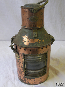
Functional object - Marine Lamp, R C Murray & Co Ltd, 1900 -1930
The item is a kerosene marine ships lamp used onboard ships and smaller vessels for general lighting and navigation the subject lamp was made by a very well known maker R C Murray of Glasgow Scotland. During the research several different addresses were found but nothing on the founder or company history. It appears RC Murray made not only marine lamps but lamps for the railways as well. The company is listed in the Scottish Post Office Directories for 1885 to 1886 as manufacturing tinsmiths, lamp makers, coppersmiths, gas fitters, bell hangers and workers in sheet iron, zinc and brass at street numbers 7, 9 and 11 Carlton Court, Bridge St Glasgow. An additional address is at 37 Cavendish St Glasgow listed for 1910, and also at Pollokshaws Road. The writer assumes the company must have moved sometime between 1886 & 1910 to these addresses. The writer at this time cannot ascertain any more historical information regarding the company or its founder, however, lamps made by RC Murray are now collector's items commanding significant sale prices on many auction websites.A significant item used in the marine industry on many ships, the company made kerosene lamps for other industries as well and was a well-known company in the early part of the 20th century.Marine kerosene ships lamp, round copper handle on top and side top is hinged with catch and lever, protruding near top.Inscribed "RC Murray and Co Limited" "Pollokshaws Road Glasgow S.1." flagstaff hill, warrnambool, shipwrecked-coast, flagstaff-hill, flagstaff-hill-maritime-museum, maritime-museum, shipwreck-coast, flagstaff-hill-maritime-village, lamp, lantern, brass lamp, nautical object -
 Federation University Historical Collection
Book, The Old Pioneers' Memorial History of Melbourne From the Discovery of Port Phillip to the World War, 1924
Blue hard covered book of 494 pages. Images, and a large plan of prominent burials in the Melbourne Old Cemetery, and a Map of Melbourne. melbourne, melbourne cemetery, melbourne old cemetery, john batman, edmund hobson, batman's map, st francis' church, james balfour, mrs hornbrook, paddy's market, wilson hall, working men's college, henry kendall, le souef's cottage, world war one, westernport, melbourne cup, hoddle, collingwood, south melbourne, prahran, richmond, kew, brunswick, coburg, preston, hawthorn, camberwell, nunawading, doncaster, st kilda, brighton, sandringham, cheltenham, caulfield, oalkleigh, footscray, sunshine, north melbourne, carlton, ballarat school of art library, ballarat technical art school, book plate, library plate, hume and hovell's overland journey 1824-5, major mtichell's overland journey, australia felix, booplate, aborigine, aboriginal, captain cook, arthur phillip, isaac smith, george bass, matthew flinders, john murray, catain baudain, captain collins, edward henty, portalnd, map od melbourne in 1938, john pascoe fawkner, the "enterprise: and fawkner's first home, old colonists' homes, rushall crescent north fitszroy, richard bourke, the old melbourne post offfice, old governmnt house, toorak, latrobe's house at jolimont, first melbourne land sale, melbourne water supply, peter henry smith, victorian legislative council opening, map of melbourne and collingwood, prince's bridge, crossing the rivers by punt, f.a> rucker, canvas city emerald hill, arrival of the gold escort in melbourne, the yarra, queen's wharf, tall ships, old st james, mary e. budd, st francis church, michael carr, meolbourne city mission, state library of victoria, melbourne public library, bourke street, angus mcmilan, methodist ladies college, ormond college, armistance celebrations, robert russell, mia mia, theatre royal bouke st, melbourne from flaggstaff hill, federal coffee palace collins st, lord melbourne, melbourne mint, old melbourne town hall, robert russell's melbourne and yarra falls, mandevalle hall, point lansdale lighthouse, wilson's promontory, margaret m. ward cole, williamstown, flinders st melbourne, queenscliff battery, broadmeadows soldiers' camp, embarkation of first troops on the 'ceramic', general monsash, ian hamilton, general bridges, victorian war memorial, national war memorial, st kilda pier, first melbourne cup, hoddle's grid, albert park, melbourne mechanic's institute, st kilda toll gate, munted policeman, springthorpe memorial, james bonwick, mornane's paddock, victorian railways melbourne and surburban lines, carlton gardens, thomas napier, wiliam westgarth, george augustus robinson, william lonsdale, elizabeth mary batman, peomena frances darling batman, dig tree, exhibition of 1854, exhibition of 1866, exhibition buildings, geelong harbour, jubilee lake, port campbell, warrnambool, queenscliff lightboat, batman's first house -
 Red Cliffs Military Museum
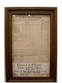
Framed Document, Officers Mess Bill for Lieutenant I.A. O'Connell 2-27th Punjabis 1919, 30/9/1919 (exact)
Provides an itemised account of mess charges and credits, eg. credit Bridge winningsAn original Mess Bill for the Officers Mess of the 2nd 27th Punjabis Regiment, 30th September 1919. Framed in a wooden frame with additional informayion on I.A. O'Donnell and family inside frame.Full listing of bill, Signature and date of mess president1919, ww1, officers, mess, 2 27th, punjabis, lieutenant, o donnell, seconded, british, army, agra -
 Red Cliffs Military Museum
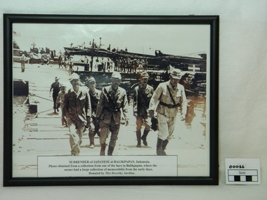
Framed Photograph, Surrender of Japanese at Balikpapan, 1945
Japanese Commanders crossing a pontoon bridge under guard by Australian soldier on the way to the official surrender of Japanese forces in Balikpapan in (Dutch East Indies) Indonesia 1945. This was a major event in the ending of World War 2. Following the japanese surrender the Local population began it push for independance. Framed photograph (copy) of Japanese Commanders surrendering at Balikpapan. Black frame and glass covered. The Japanese Command staff with a Japanese general and aid-d-camp (Captian)carring his breif case along with other staff members. In the background here are 2 American PT boats with American naval personal .Note American flag flying in the top left corner. There are several American landing craft next to a Japanese landing barge. The Japanese landing bardge has the required surrender markings which is a green square with a white cross on top right of photo. The Australian soldier following the Japanese soldiers is wearing slouch hat and gungle green uniform. Along the docks are native workers.Paper discription on lower photograph with details of item description, where photo obtained from and donated by.ww2, japanese, surrender, balikpapan, generals, americans, pt boats, japanese landing bardge, american landing craft, dutch east indies -
 Bendigo Historical Society Inc.
Photograph - BRIDGE - SINGLE SPAN
sepia photo on grey board: single span lift bridge across river. Long truss spans each side of lift section. Probably over Murray River ? On front rop right corner Mp 107. On back written ' copies obtainable from M. Clifton, Koondrook'M. Clifton ?bridge, construction, single span lift bridge -
 Bendigo Historical Society Inc.
Document - MALONE COLLECTION: GREETING CARDS
Document. Greeting Cards. Cream card with light purple shading. At the top is an oval window and another shaped window on each side. The edges of the windows are embossed with leaves and decorative edges. The scene through the windows is a village street with houses on both sides and in the foreground is a stream with a bridge and a man standing on it. A horse with a man on his back is having a drink from the stream. Below the picture is a verse from Phil. Iv., 19 and Charlotte Murray. The printing is in purple with red capitals at the beginnings. There is a mauve ribbon at the top to hang the card.The Emmanuel Series. British Manufactureperson, greeting cards, malone collection, malone collection, greeting cards -
 Echuca Historical Society
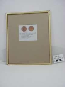
Framed Penny, Hopwood Penny
Reproduction done for Port of Echuca c.1980 heritage project. Henry Hopwood who founded Echuca in 1853, made the following charges for the use of his punt across the Murray River utiliising his own tokens. Charges - one penny for 2 sheep, six pence for 1 cow or head of cattle, ninepende for 1 horse, 18 pence for 1 horseman, "footmen" were free. 2 reproduction Hopwood Pennies, in frame with gold surrounds, pennies in centre of frameInscription BRIDGE HOTEL 1858 on one penny shows scene of Bridge Hotel and the other has inscripition HOPWOODS PUNT ECHUCA 1857 One Penny and scene of same. -
 Bendigo Historical Society Inc.
Document - RESEARCH NOTES: ONE TREE HILL, STORMWATER CHANNEL, ANTHONY TROILLOPE, HORSE TRAMWAY TO GOLDEN SQUARE
Typed and handwritten notes. Mentioned are: - Some Notes Concerning The Eaglehawk Logs, Damaging the Stormwater Channel, where some Chinese were digging away the Creek, the cutting down of the giant gum tree which gave One Tree Hill its name, How Anthony Trollope saw Bendigo in the 1870's, A Proposed Horse Tramway to Golden Square, Society’s' Trip to Bridgewater Flour Mill, A talk on a trip to Malaya by Mr D Hester, Society News and Happenings, Old Bendigonians and Safety Cages,document, various notes, eaglehawk logs, bendigo advertiser 19/10/1858, damaging the stormwater channel, bendigo advertiser 11/8/1872, harneys bridge, gas works, constable rogers, constable james bradley, joch, john o'c hattam, one tree hill, ryan, trollope's fabulous bendigo, anthony trollope, 'trollope’s australia', nelson press, alex h stone, bendigo advertiser 5/7/1897, mr peter ellis, cr hoskins, horse tramway, historical society, water wheel flour mill, june parry, mr pat wodetzki, mr leo wodetzki, neil murray, mr k hester, mr wes harry, mr i hendry, mr henry jackson, mr connelly, mr irons, mr harney, dr smith, dr hoyle, rev dr bachaus, rev dr nish, rev joseph dare, hon angus mackay, mr haverfield, mr j k robshaw, w p neal, mr george lansell, hon j h abbott, m l c, mr j casey, dr james boyd, dr atkinson, dr easie, mr t h henderson, old beehive, francis brothers, mr john crowley, mr jacob cohn, art gallery, mr hugh mcdevitt, mr alexander bayne, mr f sciallero, camp reserve, hon w i winter-irvine, mr george avery fletcher, great central goldfield of victoria, safety cages, bendigo advertiser, j h seymour, mr horwood, new chum and victoria tribute company, james watson, seymour's patent safety cage, londerry tribute, national show sandhurst, h banfield, mr a llewllyn, 'dear old bendigo', thomas bracken, mr william heffernan, mr edward (ned) ryan, mr samuel bastard, mr charles bird, mcpherson and co, fern hill club, mr george tolhurst, tolhurst brothers, union bank, mr lawrence ryan, mr shadrack jones, charley armstrong, armstrong brothers, mr abraham solomen, mr bladiere mr r t wheeler -
 Bendigo Historical Society Inc.
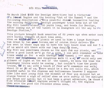
Document - VARIOUS DRAFT ARTICLES FOR RHSV (BENDIGO) NEWSLETTER FEB 1972
Various draft articles for RHSV (Bendigo) Newsletter Feb 1972. 1 Big Hill Tunnel: description of memories by Lydia Chancellor of outings to area (Picnic Day); 2. Article by A W (Lew) Llewellyn re (fist fighting) Champions of England in 1700s and 1800s (incl details of ‘‘Thompson (w.) Bendigo'' - source ''Fistiana, pub. 1857); 3. ''Phenomenal Hail Storm'' by Edith Checcucci(?) description of hail-storm of March 27th, 1914 - hail 18'' thick in Hargreaves Street - describes damage from personal recollection as a child and Annals of Bendigo from March 1914; 4. Note from Neil Murray, President entitled ''Vale - Albert Richardson; obituary and condolences to family; 5. article by ''Jock'' re Chinese Masonic Hall, Bridge Street, and the future of this building describing the nature of the building, uses, owners/occupiers; 6. Handwritten original of #5 - named author; J O'C Hattam (''Jock'')document, newspaper, bendigo advertiser -
 Tatura Irrigation & Wartime Camps Museum
Photograph, Country Scene
Original painting photographed by the artist's nephew.Colour photograph depicting undulating rural scene with a stream, bridge and farm house in the foreground.Nildunera, photography, photograph, slides, film -
Tatura Irrigation & Wartime Camps Museum
Photograph - copy, Bluebird to Boomerang Cafe in Hogan Street Tatura, 1920's mid
Original photograph of Myers family and friends shifting from Bluebird Cafe to Boomerang Cafe, mid to late 1920's. Formerly a jewelry shop. Left to right: Sarah (girlie) Colliver, Tom Myers, Nell Myers, Mark Pritchard, Tom Colliver, Bridge Myers and Neil Colliver. Black and white photograph of local identities transfering effects from Bluebird Cafe to Boomerang cafe mid late 1920's.transfer of effects from Bluebird cafe to Boomerang cafe, east of railway crossing. Props. Bridge and Nell Myersnell myers, sarah colliver, boomerang cafe tatura, n. lenehan, bluebird cafe tatura, tom myers, mark pritchard, tom colliver, bridge myers, neil colliver -
Tatura Irrigation & Wartime Camps Museum
Photograph, Alan Whiting, 1924
Taken for the Victorian State Rivers and Water Supply Commission.Mounted medium sized black and white photograph. Waranga Basin inlet structure of concrete across water / Man on horseback centre of bridge / Rock wall bottom left corner.irrigation, victorian state rivers and water supply commission, waranga basin -
Tatura Irrigation & Wartime Camps Museum
Document, Waranga Conservation Study 1988. Volume 1, 1988
Recommendations and guidelines. A study of historical data on local conservation for Waranga Shores, includes early photos of houses in Murchison and RushworthWhite plastic back, Clear plastic on front. Picture on cover of Rimes farmhouse, Bakers Bridge Road Wanalta c 1874-8. -
 Tatura Irrigation & Wartime Camps Museum
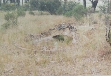
Photograph, Arthur Knee, Camp 13 stone bridge, 1989
Camp 13, administration area, s.w. corner near Commandants house. Made by prisoners using local stone.Camp 13, Camp Road, Murchison, Victoria. Stone work,ornamental pond, bridge, s.w. corner near administration area - remnants.Camp 13 West Garrison Gardens - Stone bridge over figure 8 poolcamp 13, murchison victoria, pow, internment camps, stonework