Showing 2433 items
matching museum operations
-
 Waverley RSL Sub Branch
Photograph Vietnam 1962-1973, Vietnam 1962-1973
Original in National War MuseumOn 26 August 1967 members of 5 Platoon, B Company, 7RAR were lifted by United States Army Iroquois UH-1D helicopters from their location beside the road leading to Dat Do, and returned to their base at Nui Dat in Phoc Tuy Province. These soldiers had completed the cordon and search of the village of Phoc Hai, part of Operation Ulmarra.Mounted in a wooden frame under Glass http://www.awm.gov.au/shop/item/4483/#.UVDu0BdkNe8vietnam, 7rar, ulmarra, dat do -
 Bendigo Military Museum
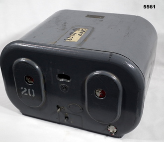
Magazine - MAGAZINE, FILM, Williamson Manufacturing Co Ltd
This photographic magazine attaches to the gear box universal ( see cat 4531). As an assembly, the type F22 aerial camera came into RAF and RAAF service c1942. It was used by the RAF over Europe and by the RAAF extensively through the Sth. West Pacific area of operations, during WW2. This type of camera was used through the Vietnam war up to the early 1980's. The F22 camera assembly when mounted in the reliable Canberra aircraft, did aerial survey work in PNG, Indonesia, Malaysia and Sumatra and the Australian mainland. This type of camera was used in Spitfires, Mosquitos, Avro Lincolns and Canberra aircraft.This is a heavy metal container painted in a grey colour. The label is on the top. One side has two enlarged oval sections. in those two ovals is one hole of 22 mm diameter. In those holes is a disc painted half red and half white. Below the ovals are two levers connected to the internal mechanism. Bottom RHS has a disc with 2 pins, red dots are printed on it. Nearly level with the top of ovals is a kidney shaped hole. In that hole is a rotating disc with graduations and numbers. the action side of magazine has a rectangular opening size 83/4" x 7/16". It is covered with a black soft material.Top has “serv 18-10-73” The number '20' has been stenciled on two surfaces.aerial photography, magazine, ww2, raaf -
 Bendigo Military Museum
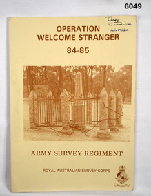
Administrative record - Army Survey Regiment - Operation Welcome Stranger - Operation Report
Operation Report of Mapping areas in central Victoria in 29 Mar 84 - 6 Mar 85. Covering 1:250,000 map areas SJ54-4 St Arnaud, SJ 55-1 Bendigo, SJ54-8 Ballarat, SJ %%-2 WangarattaAn A4 booklet sepia cardboard cover, brown text Survey Corps Badge, Photo of " Welcome Stranger Monument", outline shape of Victoria, glide on Arnos fastener binder.royal australian survey corps, rasvy, fortuna, army survey regiment, army svy regt, asr -
 Bendigo Military Museum
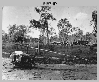
Photograph - Bell 47G-2 helicopter used in Royal Australian Survey Corps Field Operations, c1965
This is a set of four photographs of Bell 47G-2 helicopters used in Royal Australian Survey Corps Field Operations. c1965. From 1957, helicopter transport of survey parties revolutionised transport in remote areas. The most common helicopter used by the Royal Australian Survey Corps at this time was the civilian Bell 47G-2 and the Sioux, the Australian Army’s’s equivalent. equivalent. From 1964 an Aerodist MRC2 airborne Electronic Distance Measuring (EDM) system was extensively used for topographic surveys over long distances by trilateration to replace traverse requiring survey station intervisibility. In 1965 the command field survey unit personnel attached to the Army Survey Regiment’s Topographic Squadron were used mainly in support roles such as station clearing, tower operations, station monumenting, Aerodist computations, forward base operations, geodetic observations on the north-south traverse and logistic support for Remote teams. .1P is a photo of a civilian Bell 47G-2 helicopter Registration / Serial VH-UTB owned by Helicopter Utilities from Mascot, NSW c1965. In the background of this photograph is three personnel and vehicles at a field survey camp. The left-hand vehicle is a Willys Jeep with trailer and on the right is probably a Truck, 2 1/2 ton, 6x6, General Service GMC. The Bell 47G-2: VH-UTB was destroyed, and its pilot killed in tragic circumstances during a civilian survey operation on Cape York Peninsula in June 1966. .2P is a photo of a a civilian Bell 47G-2 helicopter Registration / Serial VH-IHB taken in Wyndham, WA. As the letters ‘TAA’ appear on the fuselage, the helicopter was charted from Trans Australian Airways. .3P is a photo of a Bell 47G-2: VH-UTC with survey camp in background. .4P is a photo of a Bell 47G-2 equipped with floats and unidentified personnel loading stores, possibly in Darwin. Acknowledgement: Royal Australian Survey Corps – Aerodist Years 1964-1975 Version 2021.0 Authored by Peter Jensen.This is a set of four photographs of civilian Bell 47G-2 helicopters used in Royal Australian Survey Corps Field Operations. c1965. The photographs were printed on photographic paper and are part of the Army Survey Regiment’s Collection. The photographs were scanned at 300 dpi. .1) - Photo, black & white, c1965, Bell 47G-2 helicopter: VH-UTB with survey camp in background. .2) - Photo, black & white, c1965, Bell 47G-2 helicopter: VH-IHB with survey station in foreground. .3) - Photo, black & white, c1965, Bell 47G-2 helicopter: VH-UTC with survey camp in background. .4) - Photo, black & white, c1965, Bell 47G-2 helicopter: Unidentified personnel loading stores possibly in Darwin..2P – annotated on bottom of photo ‘Wyndham Area – Helicopter drops observing party’ The other photographs are not annotated.royal australian survey corps, rasvy, army survey regiment, army svy regt, fortuna, asr, surveying -
 Bendigo Military Museum
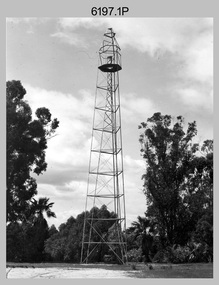
Photograph - Royal Australian Survey Corps Survey Observation Towers, c1950s
This is a set of seven photographs of Royal Australian Survey Corps surveyors setting up observation towers in the field and undertaking survey observations during mapping and geodetic control operations. c1950s. Survey observation towers were used mainly to take angular measurements in flat or heavily forested terrain, where height was necessary to achieve observer’s line-of-sight between field survey station. The Bilby Tower seen in photo .5P was erected to a height of 75 feet (23m) above ground level. The use of the Bilby Tower in Topographic Squadron’s field survey operations from 1955 to 1966 is described in page 54 of Valerie Lovejoy’s book 'Mapmakers of Fortuna – A history of the Army Survey Regiment’ ISBN: 0-646-42120-4. CAPT George Ricketts’ period of service was from 1942 to 1976 reaching the rank of LTCOL. It is noted in page 35 of Valerie Lovejoy’s book that then SGT Ricketts hand lettering skills came to the fore from his contribution to the draughting of one of the Japan’s Instruments of Surrender in 1945.This is a set of seven photographs of Royal Australian Survey Corps surveyors setting up observation towers in the field and undertaking survey observations during mapping and geodetic control operations. c1950s. The photographs were printed on photographic paper and are part of the Army Survey Regiment’s Collection. The photographs were scanned at 300 dpi. .1) - Photo, black & white, c1950s, ‘Bilby’ survey observation tower. .2) - Photo, black & white, c1950s, CAPT George Ricketts climbing ‘Bilby’ survey observation tower. .3) - Photo, black & white, c1950s, geodetic survey equipment on ‘Bilby’ survey observation tower. .4) - Photo, black & white, c1950s, two unidentified field surveyors on ‘Bilby’ survey observation tower. .5) - Photo, black & white, c1950s, two unidentified field surveyors, with CAPT Ricketts climbing ‘Bilby’ survey observation tower. .6) - Photo, black & white, c1950s, two unidentified field surveyors undertaking observations on survey observation tower. .7) - Photo, black & white, c1950, two unidentified field surveyors erecting or dismantling a survey observation tower..1P with paper tag annotated ‘Bilby Tower’ .4P on back – ‘Bilby Tower’. .5P on back – ‘Survey Observing Tower. Observing tower used for angular measurement in flat country. 75’ high – CAPT Ricketts climbing. .6P, .7P on back. ‘1960s?’royal australian survey corps, rasvy, army survey regiment, army svy regt, fortuna, asr, surveying -
 Bendigo Military Museum
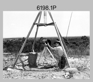
Photograph - Royal Australian Survey Corps Electronic Distance Measuring Equipment Demonstration, c1960s
This is a set of five photographs of CAPT James ‘Jim’ Leslie Stedman in the field demonstrating the setup of prisms used as electric distance measurement (EDM) receiver reflectors for tellurometer equipment and the sighting of a large surveyor’s light. This equipment was deployed in establishing mapping and geodetic control operations. The photos were most likely taken in the late 1950s or early 1960s. The tellurometers of this era were man-portable systems that improved geodetic survey efficiencies for rapid network extension and densification replacing triangulation with EDM and theodolite traverse sometimes using Bilby Towers to extend line lengths. Jim Stedman later reached the rank of Colonel, was Director of Military Survey from 1975 to 1978 and was appointed as Colonel Commandant (honorary appointment, Retd) of the Royal Australian Survey Corps from 1978 to 1983. Jim Stedman is demonstrating EDM equipment. See item 6180.16P, photos .14) to .16) for more information and photos of Jim Stedman’s EDM demonstration. This is a set of five photographs of a surveyor in the field demonstrating electric distance measurement (EDM) equipment. c1950s – 1960s. The photographs were printed on photographic paper and are part of the Army Survey Regiment’s Collection. The photographs were scanned at 300 dpi. .1) to .2) - Photo, black & white, c1960s, CAPT Jim Stedman demonstrating the sighting of a large surveyor’s light. .3) to .5) – Photo, black & white, c1960s, CAPT Jim Stedman demonstrating EDM prism equipment. .1P to .5P on back – CAPT Stedman EDM Eqpt.royal australian survey corps, rasvy, army survey regiment, army svy regt, fortuna, asr, surveying -
 Bendigo Military Museum
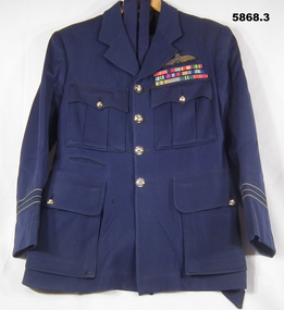
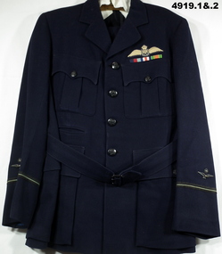
Uniform - UNIFORM, RAAF, 3) Trent Nathan
RAAF uniform worn by Squadron Leader Ian A. 'Joe' Lyons, Operations Officer for No. 77 Squadron. Part of the Ian A. 'Joe' Lyons MBE Collection. See Catalogue No. 5374P for details of his service record..1) RAAF uniform jacket, dark blue in colour. Black fabric inner lining. Gold coloured buttons. Coat has two button down breast pockets and two button-down side pockets. Dark blue fabric belt with metal buckle is threaded through two belt loops. Three rows of service ribbons including an MBE ribbon and pilot officer's wings on left hand breast. Rank insignia on the bottom of each sleeve. .2) Dark blue fabric trousers with two side pockets, belt loops and button fly. Buttons for braces on the inner waist band. .3) Dark blue fabric tie. Manufacturer's label on keeper loop..1) On label sewn into neck: 'M TX'. .2) On label sewn onto inside waist band: ' M TX'. .3) On keeper: Trent Nathan'.uniform, raaf, ian a. 'joe' lyons -
 Bendigo Military Museum
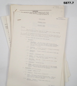
Document - INSTRUCTIONS, ARMY TRAINING, STEWARDS COURSE, Aust Army, unknown
4. Mess Operation, setting of table, folding serviettes, tapping a keg of beer. 7. The prices will bring tears to your eyes, i.e. Packets of cigarettes 38 - 41 cents each.1. A4 size - culinary terms. RAASC Centre Puckapunyal - 5 pages. 2. Foolscap - Systems of food service. RAASC centre, Oct 1962 - 6 pages. 3. Foolscap - kitchen & personal hygiene, RAASC Centre Aug 1964 - 6 pages. 4. Foolscap - Mess Operation. RAASC Centre - 29 pages - Jan 1960. 5. A4 size - 1/71 Basic Stewards Course 3 Feb, 7-24 Feb 1971. GTF Area. 6. Single sheet ASCO Mess Requisition Form - N40A Dated 8/2/71. 7. 6 Task Force SGS Mess Stocktake and cash results.1. 3795952 Pte W.D. Patterson - has some ticks and pencilled changes. 2. 3795952 Pte W.D. Patterson. 3. 3795952 Pte W.D. Patterson. 4. 3795952 Pte W.D. Patterson. 5. Red ink amendments - dates & ticks. 6. ASCO form N.40A Mess requisition NR 67510 - Cannon Hill, Enogerra. 8/2/71. Sgts Mess Stocktake. 7. Lots of additions, prices and mistakes.messing, aust army -
 Bendigo Military Museum
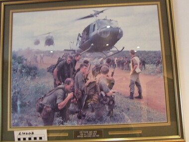
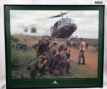
Print - PRINT, FRAMED
Caption under print. Soldiers of 5 Platoon, B Company, 7 RAR, preparing to board VS Iroquois helicopters during operation Ulmarrah, the cordon and search of Lang Phuoc Hai Village, South Vietnam, 26 August 1967". Members of 5 Platoon, B Company, 7th Battalion, The Royal Australian Regiment (7RAR), just north of the village of Lang Phuoc Hai, beside Route 44 leading to Dat Do. United States Army Iroquois helicopters are landing to take them back to Nui Dat after completion of Operation Ulmarra, the cordon-and-search by 7RAR of the coastal village of Lang Phuoc Hai. Operation Ulmarra was conducted by 2nd Battalion, The Royal Australian Regiment (2RAR) and 7RAR with support elements. Left to right: Private (Pte) Peter Capp (kneeling); Pte Bob Fennell (leaning over, facing camera, with an ammunition belt for an M60 machine gun slung over his shoulder); Corporal Bob D'Arcy (partly obscured behind Fennell); Pte Neal Hasted (centre, front); Pte Ian Jury (partly obscured, centre, rear, holding rifle); Pte Colin Barnett (front, right, M60 ammunition belt on back, back of head to camera); Lance Corporal Stan Whitford (partly obscured behind Barnett); the helicopter marshal at right is Pte John Raymond Gould, 7RAR. The United States Army Iroquois UH-1D helicopter was operated by 2 Platoon, 162nd Assault Helicopter Company, 11th Combat Aviation Battalion. (Having achieved almost the status of an icon, this image was chosen for, and is etched on, the Australian Vietnam Forces National Memorial on Anzac Parade, Canberra, ACT, dedicated in October 1992). Source AWM Print donated and dedicated to 3789179 FRANK FRIGERIO, 5 Platoon, B Company, 7RAR. See also Cat No. 3543-3549.3Print - coloured print of a photograph depicting three helicopters coming in to land above a dirt road with several groups of soldiers in uniform with jungle vegetation in the background. Frame - black painted metal.See in context, historical - caption under print.prints, framed, accessories, vietnam war -
 Bendigo Military Museum
Equipment - AMMUNITION POUCH, Tactical Operations Products Oregon USA, C.1990’s
Item issued to John Michael Giffard No 0327699 EOD Aust Army Training Team Iraq, rotation 8.Pistol ammunition pouch, 2 pouches, light Kahki colour, velcrose straps, metal studs.ammunition, pouches -
 Bendigo Military Museum
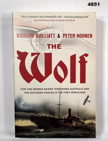
Book - BOOK, WW1 NAVAL HISTORY, GUILLIATT Richard & HOHNEN Peter, " THE WOLF', 2009
"THE WOLF' How one German raider terrorised Australia and the Southern Oceans in the First World War.Soft cover book. Soft cover - cardboard, red and black print on front, spine and back. Cover - colour illustrated - front - top German symbol, bottom, ship at sea. Back - sepia photograph - sailor and girl. 366 pages - cut, plain, off white paper. Illustrated black and white photographs and maps.Nilbook, ww1, naval operations -
 Bendigo Military Museum
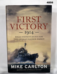
Book - BOOK, Naval Operations Australia & Germany WW1, CARLTON Mike, "First Victory 1914", 2013
"FIRST VICTORY 1914 - HMAS SYDNEY'S HUNT FOR THE GERMAN RAIDER EMDEN."Hardcover Book with Dust cover. Hardcover - cardboard, red buckram, silver print on spine. Dust cover - paper: Red gold and white print on front, spine and back. Dust cover, colour illustrations - front copy of painting of HMAS Sydney in battle with SMS Emden by the late Phil BELBIN. 467 pages, cut, plain, off white paper, illustrated - black and white, sepia and colour photographs, paintings, diagrams and maps. End papers and flyleaf - front and back - coloured green.books, naval operations, ww1, australia, germany -
 Bendigo Military Museum
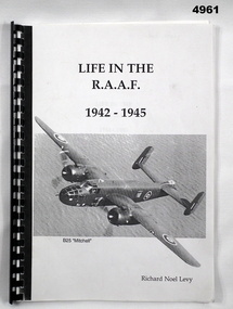
Uniform - UNIFORM, AIR FORCE, 1) .2) Carr, Son and Woor LTD, C.1944
Richard Noel Levy No 428329 RAAF enlisted on 10.10.1942 age 18 years, he flew with No 180 Sqd "B 25 Mitchell Bombers" flying 49 missions over Germany, his first operation was on 30 11.1944, discharged from the RAAF with the rank of Flying Officer on 3.1 1946.1) RAAF uniform jacket dark blue colour, inner soft lining complete with buttons, belt, Pilot Officers insignia and 3 x service ribbons being 1939 - 45 star, France and Germany Star and Defence medal. Tag on inside pocket with makers and owners details, sleeves have metal crown and wings on. .2)Trousers, dark blue complete with buttons, tag sewn on with makers and owners details. .3) Hat peak RAAF blue colour with Crown and Wings on front, black hat band with black leather strap, leather liner, tag sewn on inside..1) On tag in pocket, " "Oct 1944 P/O R.N.Levy RAAF". .2) Same as .1) .3) "R.N.Levy"raaf, uniforms -
 Bendigo Military Museum
Book - DIARY
The book covers the record of service of Richard Noel Levy No 428329 RAAF. refer Cat No 41919.3 for service history.Diary in folder style, B & W al paper with plastic binding, cover has photo of a “B 25 Mitchell bomber” with authors name, 54 pages of RAAF history, operations flown on, documents, operation log entries, photos. This version is a photo copy.“Richard Noel Levy”books, raaf, diary -
 Bendigo Military Museum
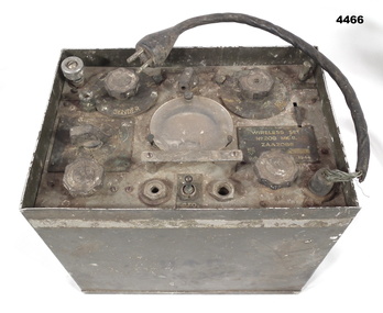
Equipment - WIRELESS SET 1944, 1944
This is a 6 valve portable transceiver, made in Australia from a British design. It was only used for C.W. (morse code). Its frequency was in the range of 2.5-3.5MHz. Output power 0.5-5 watts. Use was for commando and infantry patrols up to battalion level. It had an external battery pack for low and high voltage supply. 1 man operation in Tropics. An image of this type of wireless set in operation can be found in the AWM Collection: P02952.012 081815 Aluminium box, cover missing. The top has various dials, jacks and one gauge. There is a small length of cable coming from the control panel to a 4 pin plug. On the outside of case is the phrase D (arrow up)D 208 MKIIPlaque on control panel "WIRELESS SET - ZAA 2088 SERIAL NUMBER 168 DATE = 1944"wireless, wwii -
 Bendigo Military Museum
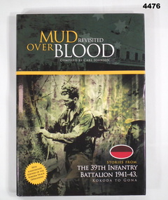
Book - BOOK, 39TH BATTALION, Carl Johnson, "Mud Revisited Over Blood"
Stories from the 39th Battalion 1941-43, Kokoda to Gona. 70th Anniversary Edition of the Kokoda Track operations, WWII.Hard cover book with dust cover (dust cover same as book). Hard cover - cardboard with dark green glossy coloured background. White and gold print on front, spine and back. Front - illustrated black and green toned photograph of 2 soldiers in uniform in jungle. Back - black and white photograph of 7 soldiers. Brown over red oval colour patch front and back. Front and back flyleaf and end papers illustrated dark green and white maps. 320 pages, cut, plain, white. Illustrated black and white photographs, portraits, documents and maps.Opposite Title Page - printed donation label - "Donated by 39th Australian Infantry Battalion (1941 - 43) Association Inc. www.39battalion.com” books, military, history, wwii -
 Bendigo Military Museum
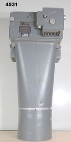
Equipment - AIR CAMERA ACCESSORY, Williamson Mfg. Co. Ltd
This Gear box universal, with its Cone assembly ( inc lens) in conjunction with Magazine 500 exposures unit ( see CAT 5561) is part of the F22 aerial camera assembly. As an assembly, the type F22 aerial camera came into RAF and RAAF service c1942. It was used by the RAF over Europe and by the RAAF extensively through the Sth. West Pacific area of operations, during WW2. This type of camera was used through the Vietnam war up to the early 1980's. The F22 camera assembly when mounted in the reliable Canberra aircraft, did aerial survey work in PNG, Indonesia, Malaysia and Sumatra and the Australian mainland. This type of camera was used in Spitfires, Mosquitos, Avro Lincolns and Canberra aircraft.Heavy, metal construction. The base is a rectangular box shape and mounted to that is a funnel shaped tube. Inside the tube are numerous small baffles around the sides painted matte black. The box has a 7 pin electrical connector. The box section can be opened by releasing catches. It has a timber base. Near the mouth of the tube, outside, is a panel with a slot and indentations F5.6 F8 F11 F16.There is a tape label near mouth if tube with writing embossed "LENS S/NO 2767849" The box has a label "GEARBOX/UNIVERSAL. MODEL 14A/4249 SERIAL No. 1685"aviation, reconnaisance, camera, photography -
 Bendigo Military Museum
Photograph - HOSPITAL PHOTOGRAPHS, Originals 1915, 1916
The photos relate to a collection re Robert O’Donahoo No 1399 AIF WW1. Refer Cat No 1500 for his service history. .1) Robert is the soldier with the arrow pointing down to him. On the rear of the card is a letter to his Mother which appears to be dated Oct 22nd 1915. He tells his mother about a 2nd operation on his leg that was amputated. Sister West is the Nurse behind him and the other is Sister Raymond. .2) The Hospital where Raymond was admitted to in England. .3) On the rear of the Post card in pen, “twin Sisters UREN who were on the Hospital ship Thermistocles on the way home in 1916, they lived in Adelaide. .4) Robert O’Donahoo is the Soldier standing on the left, on the rear of the photo in blue pen, “Caulfield Hospital 1916” The twin Sisters were Catherine Temby UREN, Amelia UREN. Robert had some 15 operations on his leg then a further 3 to correct the position of his leg which is evident in .1).1) Photo Post card, copy of original, B & W showing 4 wounded soldiers, 2 Nurses and possibly 2 Orderlies outside a hospital Ward. .2) Photo Post card, copy of original, view of a large Hospital area complex. .3) Photo Post Card, copy of original, B & W, 2 Nurses sitting on deck of a ship. .4) Photo Post Card, copy of original, sepia tone showing 4 soldiers, 2 standing with walking sticks, 2 sitting’photography, hospitals nurses, military ww1 -
 Bendigo Military Museum
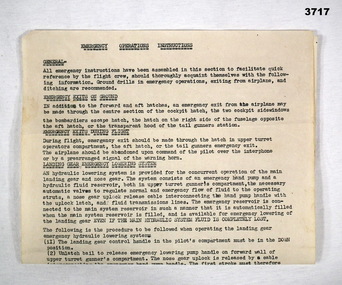
Document - DOCUMENT - AIRCRAFT EMERGENCY OPERATIONS INSTRUCTIONS, c.WWII
Item in the collection of Arthur Thomas MANLY No 431130 RAAF. Refer Cat No 3710 for his service details.Foolscap size, typed instructions, single sided. Topics: General, Emergency Exits on Ground, Emergency Exits During Flight, Landing Gear Emergency Lowering System, Emergency Hydrulic Operation of Main Landing Gear Down Position Latches, Caution.In black type at top: EMERGENCY OPERATIONS INSTRUCTIONSdocument, raaf, ww2 -
 Bendigo Military Museum
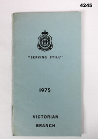
Booklet - RSL BOOKLET, Retrurned Services League Victorian Branch, 1975
The booklet contains details on the RSL’s operations in welfare, appeals, funerals and commemorative. Item in the collection of Lawrence Vernon Andrews VX114736. Refer Cat No 4228 for his service details.Soft cover light blue Booklet with 32 pages. Front cover, “Serving still 1975 Victorian Branch”rsl, victorian branch -
 Bendigo Military Museum
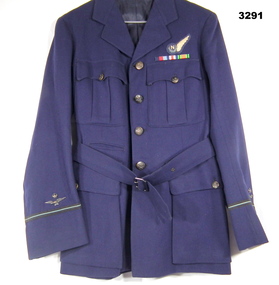
Uniform - TUNIC, RAAF, c.1939 - 1945
Item issued to Geoffrey Wilkin NEVILLE No 438263 RAAF. Rank, Flying Officer. Enlisted 10.9.1943 aged 18 years. Discharged 6.3.1946, posting at discharge, 460 SQD RAAF. Neville was posted to 460 Sqd 22.7.1945 to 6.10.1945, his Sqd during operations over Europe is unknown at this time.RAAF uniform tunic. Dark blue with waist belt. Over left hand breast pocket a woven patch with the letter N (Navigator) & one wing to the side. Under are x 3 service stripes sewn on - 1939-45 Star, France & Germany Star, Defence Medal, on sleeves are metal crown and wings.uniforms airforce, raaf -
 Bendigo Military Museum
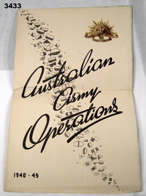
Poster - CHART WW2, ARMY OPERATIONS, LHQ Cartographic Coy, Aust Survey Corps with Directorate of Public Relations, A Chart of Australian Army Operations 1940 -1945, Post WW2
Strong paper chart folded 3 times. Front panel has title Australian Army Operations 1940 - 1945 printed in black ink, black & white divisional unit colour patches & gold coloured Rising Sun. Inside are 4 maps including Mediterranean Sea area, New Guinea, Pacific Islands - Borneo & Malaya. One panel has a chronology chart showing dates & events during 1939 - 1945.chart, operations, army 1939 - 45 -
 Bendigo Military Museum
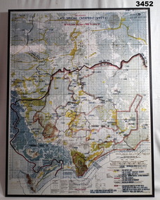
Map - MAP, MOUNTED VIETNAM, C. Late 1960’s
Australian area of Operations.Map of Phuoc Tuy Province showing civilian access areas in colour. Laminated surface on board backing with black border &mall hanging strap on back.Top centre: “UNCLASSIFIED. LATE SPECIAL OVERPRINT (SHEET 1)map, vietnam -
 Bendigo Military Museum
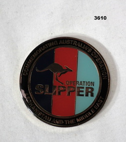
Memorabilia - COMMEMORATION MEDALLION, Post 2014
Heavy metal & enamel, circular medallion. Centre has 3 coloured stripes, dark blue / red / light blue. Rear is embossed with Australian Coat of Arms, black on gold.In centre over stripes: A kangaroo with words “OPERATION SLIPPER” Circumference: COMMEMORATING AUSTRALIAN OPERATION - AFGHANISTAN AND THE MIDDLE EAST” Rear: “OPERATION SLIPPER AUSTRALIA 2001 - 2014” medallion, slipper, operation, commemoration -
 Bendigo Military Museum
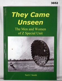
Book - BOOK, WW2, Neil C Smith, They Came Unseen, 2010
They Came Unseen - The men and women of 2 Special Unit. From back cover: Secret operations behind enemy lines in the Pacific War during World War Two were vital in winning he war against the Japanese. Author: Lieutenant Colonel Neil C Smith, AM” Hard cardboard cover, gloss paper. Yellow print on front spine & back. Green background, illustrated front cover, black / white photo of soldier with parachute. Back cover has colour photo of 2 Special Unit Association ANZAC Day March. 264 cut, plain, white pages. Illustrated black / white photos & maps. Handwritten on title page in black ink: “Neil Smith”book, z special, came unseen -
 Bendigo Military Museum
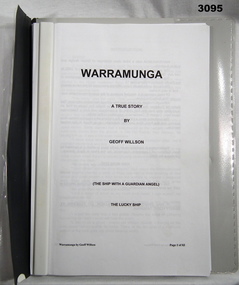
Booklet - BOOKLET, RAN, Warramunga
Soft clear plastic & grey covered file with dark grey reinforced spine, hole punched. 83 typed photocopied pages. Warramunga was a tribal class destroyer of British design & built in Australia. Booklet contains author's recollections of her part in naval operations in the Pacific theatre of WWII."Warramunga a true story by Geoff Willson", "The Ship with a Guardian Angel", "The Lucky Ship"military history-navy, ran, hmas -
 Bendigo Military Museum
Document - DOCUMENT RAAF, c.1945
Item belonged to Maxwell Lennox Matheson No 418447 RAAF. Refer Cat No1959 for his service record.RAAF Squadrons 1939-45, 4 pages stapled. Details of Squadron number, Squadron code, main types of aircraft & general area of operations.'Appendix 5' also stamped on top right corner is the donor's name & addressdocuments - catalogues, raaf -
 Bendigo Military Museum
Letter - LETTER, VIETNAM, 3.8.1992
Letter written to Mrs Reidy by her son Paul's Section Commander BRUCE D SCOTT. It details the circumstances of PAUL REIDY'S death in Vietnam on 25.5.1969. It was during “Operation Reynella” around the Long Hai Mountains. Paul Francis Reidy No 3793403. A National Serviceman Paul served Vietnam first in 1 ARU from 24.2.1969 - 17.3.1969 and then posted to B Coy 9 RAR 18.3.1969 until his death. Bruce Donaldson Scott No 213485. Australian Regular Army served Vietnam first in 1 ARU from 10.3.1969 - 1.4.1969 and then posted to B Coy 9 RAR 2.4.1969 until being Medivaced home on 2.6.1969. 1 ARU (1st Australian Reinforcement Unit) 9 RAR (9th Battalion of the Royal Australian Regiment) Refer 1189.5, 2224, 2237.2P re Paul Reidy. Copy of typed two page letter on A4 paper from BRUCE D SCOTT to Mrs Reidy.documents - letters, military history -
 Bendigo Military Museum
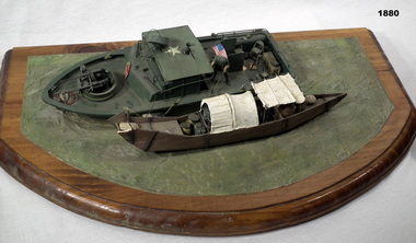
Memorabilia - DIORAMA VIETNAM, Post 1975
Diorama of US river operation in Mekong Delta showing a US patrol boat with a local village boat alongside, model hills and figurines. On tan wooden base with green background. military history-army, handcrafts, diorama, riverine -
 Bendigo Military Museum
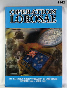
Book, Chief Editor Major Steven Ferndale, Operation Lorosae. 1st Battalion Group Operations in East Timor October 2000 - April 2001, 2001
Francis W Dean BEMCover. Hard, coloured, with photos of war scenes over both covers. Black & white print on cover. Colour & black & white photos. 206 pages.To Francis Dean, Thanks for your support from Commanding Officer and All Ranks. J Ball 7 Dec 01.books, military history