Showing 126 items
matching alps
-
 Kiewa Valley Historical Society
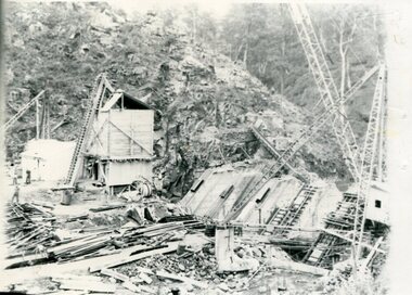
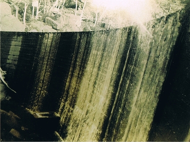
Photographs x 2 - Clover Dam, Circa 1940's
As part of the push to cut electricity costs and diversify supply, the Victorian Government (circa 1930) implemented the conversion strategy from mainly brown coal supply to hydro - electricity. The Kiewa Hydroelectric Scheme became the largest scheme of its kind in the State Of Victoria and the second largest scheme in Australia. Clover Dam and Power Station were built by the State Electricity Commission of Victoria as part of the Kiewa Hydro Electric Scheme from the late 1930's to the early 1940's. This dam was constructed to supply water to feed four turbines (62 mega watts) at the West Kiewa Power Station. This was at the forefront of sustainable "Green" energy. Costs associated with power supplies is still a major incentive of governments, however environmentally friendly alternatives such as wind and nuclear have also made inroads. The Kiewa valley and its surrounding alpine catchment were looked at(Victorian State Government), from the beginning of the twentieth century as a source of alternate power for an ever-increasing demand for electricity by growing population and heavy industrial areas within Melbourne City and State regions. Construction of dams, such as Clover Dam provided the large quantity holding areas of water required to turn the turbines at the various power stations to provide the electricity needed. The impact of these controls by moderating water run-off from the alpine regions is beneficial in reducing flooding from thawing of snow on the alps. This by-product allows agriculture and grazing to be less vulnerable to seasonal flooding thereby resulting in a more stable annual production level. Photographs also document early engineering and building techniques used in the construction of dams and power stations during the 1940’s and 1950’s. Note the lack of safety equipment and suitable work attire worn by construction workers on the sites 1. Black and white photograph of Clover Dam under construction. Has a .5cm white border around photo 2. Black and white photograph of Clover Dam under construction showing workmen at work. Has a .5cm white border around photo Written in pencil on back of both photographs - Clover Damclover dam, secv -
 Kiewa Valley Historical Society
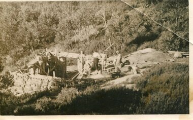
Photograph - Building of Myrtleford Ski Club
Myrtleford Ski Club is a non-commercial, family friendly club. It was one of the earliest lodges to be built at Falls Creek and was one of the earliest ski clubs formed and celebrated its 75th anniversary in 2013. In 1949, Myrtleford Ski Club obtained permission for occupancy and began planning the MSC Lodge. There were only three other huts on the mountain, Bogong Ski Club in an old Army hut, Skyline as the Ski Club of Victoria lodge and the Albury Ski Club lodge. The lodge was built mostly from donated materials. The basement was dug out and lined with stone from the Ruined Castle area, timber was cut (using cross-saws) from the Walpole properties and was milled then carted up to Falls Creek on either the Walpole or Calvert trucks. The iron on the roof was originally a tobacco kiln on Billy McNamara's property. The lodge has undergone many improvements over the years including a second storey added in the 1950’s, updating of accommodation, shower and toilet facilities to meet the changing needs of members. The lodge now caters for 38 people in a variety of shared rooms from two to eight beds per room. Toilet and shower facilities are also shared. The club has a Lodge Managers for the winter season. Myrtleford Ski Lodge was one of the earliest ski lodges built in the Falls Creek area in 1938. It is an excellent example of early sporting and community activities in the Upper Kiewa Valley area. Photograph shows family members, including women, involved in the construction.Sepia photograph of the building of the Myrtleford Ski Club about 1948Handwritten on the back of photograph in black pen - Building Myrtleford Ski Club (about 1948) Stamped on back of photograph - 6 2511myrtleford ski club, skiing, snow sports, victorian alps, falls creek -
 Kiewa Valley Historical Society
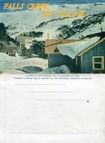
Souvenir Postcard Folder – Falls Creek Ski Village
After World War II, the Kiewa Hydroelectric Scheme was started in the Kiewa River valley by the State Electricity Commission of Victoria. On land previously used only for summer cattle grazing in the natural alpine grasslands, the first ski lodge was built in 1948 by workers from the scheme. The first lift, a rope tow, was built in 1951 and the first chairlift in Australia was constructed there in 1957. Falls Creek Post Office opened on 9 June 1958 (with telegraph and telephone facilities only until 1964) .Despite strong opposition from the head of the Kiewa scheme, who didn't want tourists clogging up his roads and destroying his "dry" construction camps by bringing in booze, Falls Creek boomed as much as Hotham, partly owing to its relatively good access road. Early lodges included Bogong (c.1946), Skyline (1947), Albury (1949), Myrtleford (1949) and Dawn (c.1950).The souvenir postcard photographed and produced by an enterprising local businessman Mr S K Pearce, was produced as a memento for skiers and other visitors to the Falls Creek and Mt Beauty area to send to family and friends as a reminder of their visit to the region, or to keep as a personal souvenir. It presented an excellent promotional opportunity for enterprising local businessmen to promote the area to skiers and tourists near and far. It also presents an excellent pictorial history of the falls creek area around the late 1950’s to early 1960’sColour postcard folder (unused) containing 13 photographs of the Falls Creek ski area and surrounds. Inside cover has a brief description of the area and the services available to visitors Printed on front cover- FALLS CREEK SKI VILLAGE. Your Souvenir Folder Photo of skiing slopes of the village Inside front flap - a brief description of the Falls Creek area and the services available to visitors 1. Diana Lodge parking area and Spion Kopje 2. Winterhaven Lodge 3. Ski Hirage Centre and skiing slopes 4. Ski Lodges from main road 5. Nelse and Arundel Lodges 6. Day visitors’ shelter and parking area 7. Summit T-Bar lift 8. Spur T-bar looking towards Village and Spion Kopje 9. T-bar lower station and Snow Crystal Inn 10. ‘Akja’ rescue sled in use 11. Falls Creek road and Grand Coeur Lodge annex 12. Rope tows and beginner slopes 13. Back cover- Published by Nucolorvue Pty Ltd Mentone Vic. Printed in Australia For S.K.Pearce Pty Ltd Tawonga and Mt Beauty falls creek, snow, bogong high plains, victorian alps -
 Kiewa Valley Historical Society
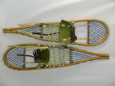
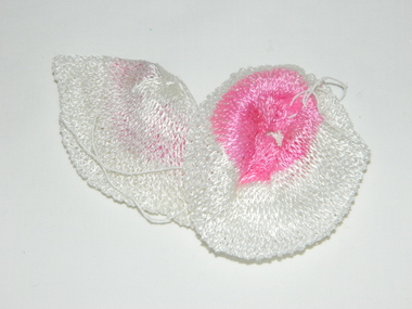
Snow Shoes
Snow shoes were used to move between places on the snow fields at Falls Creek and the Bogong High Plains especially during the construction of the Kiewa Hydro Scheme.Historical: Snow shoes were used on the Bogong High Plains during winter. The body is made of light wood 'bamboo' with a back and front wooden cross bar. Between the front cross bar and toe, blue nylon is tied to form diamonds 'lacing', similarly the back. Between the bars, in the middle is cream coloured rope tied to form a strong basket. A shoe harness made of olive green vinyl to which is clipped brown strong woven material tape with a circular steel loop through which the tape is threaded. There are 3 steel fasteners on 1 side and 2 on the other with a black plastic fastener. At the front between the cream and blue woven baskets there is a gap called the toe hole. The rope is attached either side of the toe hole to the front wooden bar.snow. falls creek. bogong high plains. transport. victorian alps. -
 Kiewa Valley Historical Society
Book - A.L.P.S, A Good Life - A.L.P.S. x2, 1998
A.L.P.S. began an ongoing project to record the contribution made by women to life in the Kiewa Valley.An original history of the Kiewa Valley focusing on women from various backgrounds.A soft covered book with clear plastic cover of 81 pages with a blue cover, black written heading including A.L.P.S. Inc. logo and red plastic 'spiral' spine."Val Woinarski" & phone number inside on the first page.community group in the kiewa valley; alps -
 Lara RSL Sub Branch
Book, Victory Roll - The RAAF at War, 1952
The stories in 'Victory Roll' tell of some of the deeds performed in the final and victorious year of WWII. They add to a long tradition of gallant service and sacrifice and will serve as an eternal inspiration in the task of building a new world in which the spirit of the Four Freedoms must predominate. In making final victory possible, we lost many comrades, to w home this book, together with those which preceded it, becomes a permanent memorial.Green hardcover and spine with black text - 'Victory Roll The RAAF at war' on front cover and spine. The inside front and back covers have silhouette, green sepia pictures of a variety of aeroplane. Illustrations, photographs and cartoonsMessage from the Chief of Air Staff.... Air Vice Marshal, Chief of Ai Staff C.Joneswwii, raaf, end of conflict, test pilot, wewak, the sisters fly on, battle of borneo, the biscuit bombers, anzacs on bougainville, raaf pacific, return to timor, pacific landing, long range from darwin, air victory over burma, lifeline to china, photo recce, first over malaya, jungle dawn, the victory in europe, story of a prison camp, night flight over hamburg, youth's prayer at a war memorial, victory at the alps, waaf's good service -
 Kiewa Valley Historical Society
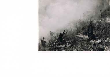
Photograph Fire Prevention Victorian Alps, Burning, Circa 1950
This photograph, in late 1950s, shows an Alpine Fire Prevention technique of "burning off" low levels of scrub to reduce the level of available fuel against any possible summer bush fires. The Alpine regions accumulate high levels of potential fuel (undergrowth and small shrubs) which if not reduced has the potential of breaking into a dangerous bush fire. The men in this photograph are not wearing any protective clothing. Their visibility to other firefighters is severely reduced by smoke. This photo is a snap shot in time when Occupational Health and Safety Legislation was in its infancy stage.This photograph details the fire prevention activities in the Victorian Alps under the management of the SEC Victoria. The level of undergrowth within the Australian bush needs to be kept under control to avoid the possibility of lightning strikes (during summer storms) igniting dry forests resulting in a major bush fire. Controlled fires within alpine regions are required not only to reduce the level of dry undergrowth but also to provide those various plant species requiring fire for regenerate. This method was used by the original inhabitants (Aborigines) as limited scrub fires were used to flush game and bird population for eating with the side benefit to those plants requiring the fire for regeneration.This black and white photograph shows an Alpine Fire Prevention technique of "burning off" low levels of scrub. The photograph is on 200gsm paper but it is not photographic paper. It can be assumed that the photo is not the original but a copy. alpine fire prevention, sec fire prevention -
 Kiewa Valley Historical Society
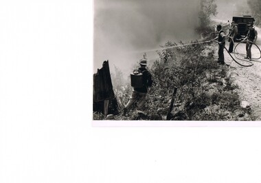
Photograph Fire Prevention Victorian Alps, Burning, Circa 1950
This photograph, from the 1950s, shows an Alpine Fire Prevention technique of "burning off" low levels of scrub to reduce the level of available fuel against any possible summer bush fires.The Alpine regions accumulate high levels of potential fuel (undergrowth and small shrubs) which if not reduced has the potential of breaking into a dangerous bush fire. The men in this photograph are not wearing any protective clothing. Their visibility to other firefighters is severely reduced by smoke. This photo is a snap shot in time when Occupational Health and Safety Legislation was in its infancy stage.This photograph details the fire prevention activities in the Victorian Alps under the management of the SEC Victoria. The level of undergrowth within the Australian bush needs to be under control to avoid the possibility of lightning strikes (during summer storms) igniting dry forests resulting in a major bush fire. Controlled fires within alpine regions are required not only to reduce the level of dry undergrowth but also to provide those various plant species requiring fire for regenerate. This method was used by the original inhabitants (Aborigines) as limited scrub fires were used to flush game and bird population for eating with the side benefit to those plants requiring that fire for regeneration.This black and white photograph shows an Alpine Fire Prevention technique of "burning off" low levels of scrub. The photograph is on 200gsm paper but it is not photographic paper. It can be assumed that the photo is not the original but a copy produced by the SEC Vic. See also KVHS 0413 and KVHS 0414 for other similar photos.kiewa valley tourism, victorian alps, alternate energy supplies, alpine population growth -
 Kiewa Valley Historical Society
Photograph Fire Prevention Victorian Alps, Burning, Circa 1950
This photograph, in late 1950s, shows an Alpine Fire Prevention technique of "burning off" low levels of scrub to reduce the level of available fuel against any possible summer bush fires. The Alpine regions accumulate high levels of potential fuel (undergrowth and small shrubs) which if not reduced has the potential of breaking into a dangerous bush fire. The men in this photograph are not wearing any protective clothing. Their visibility to other firefighters is severely reduced by smoke. This photo is a snap shot in time when Occupational Health and Safety Legislation was in its infancy stage.This photograph details the fire prevention activities in the Victorian Alps under the management of the SEC Victoria. The level of undergrowth within the Australian bush needs to be kept under control to avoid the possibility of lightning strikes (during summer storms) igniting dry forests resulting in a major bush fire. Controlled fires within alpine regions are required not only to reduce the level of dry undergrowth but also to provide those various plant species requiring fire for regenerate. This method was used by the original inhabitants (Aborigines) as limited scrub fires were used to flush game and bird population for food, with a side benefit to those plants requiring the fire for regeneration.This black and white photograph shows an Alpine Fire Prevention technique of "burning off" low levels of scrub. The photograph is on 200gsm paper but it is not photographic paper. It can be assumed that the photo is not the original but a copy. See also KVHS 0413 and KVHS 0415 for other similar photos.kiewa valley tourism, victorian alps, alternate energy supplies, alpine population growth -
 Kiewa Valley Historical Society
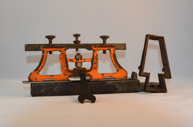
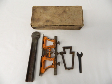
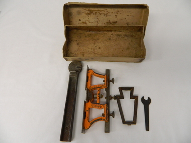
Sharpener Saw Raker/Jointer, early 1900s
This raker/jointer/guage set is a sharpening tool for cross cut logging saws. The logging saws used in the early 1900's for the clearing of forests required constant sharpening of their "cutting teeth". The logging of forested areas during these times was very much a "hands on" method of either one or two men by the use of saw or hand axe. Chain saws, chain and ball(clearing) and bulldozing methods came in the mid 1900's.This particular saw sharpening method was used by surveyors laying down boundaries for the S.E.C. Victoria Hydro Electricity Scheme (1920's). This item was given to a local Kiewa Valley lad who accompanied the initial surveyors. The lad was responsible for the tendering and feeding of the surveyors "pack horses". Surveys during this period and in the dense mountainous terrain of the Victorian Alps was both exhausting and hazardous. Overnight accommodation at various log cabins was not always possible and swag/tent alternative was the "fall back" This raker/jointer saw sharpener was made in the USA (DISSTON) from cast and flat iron. The main body has been painted in orange. It has three adjustment screws on the top horizontal bar and one bolt on(adjusting) leveling platform on the bottom. The small size and weight of this saw sharpener was ideal for the travelling/mobile logger or surveyor(as in this case). The main frame resembles two towers connected by two horizontal bars and the top of the towers has a horizontal bar with adjustment screws. See KVHS 0090 (B) for setting stake wedge adjusting the rake and cutting angle and KVHS 0090 (C) for a small spanner (for adjustments).On one inner supports is stamped "DISSTON" and on the other "U.S.A."hand tool, saw, sharpening method, tree felling. -
 Kiewa Valley Historical Society
Tool Spring Set, circa early 1900s
This is part of a crosscut saw raker/jointer/guage set used to bend the tip of each cutter tooth for cross cut logging saws. The logging saws used in the early 1900's for the clearing of forests required constant sharpening of their "cutting teeth". The logging of forested areas during these times was very much a "hands on" method of either one or two men by the use of saw or hand axe. This item was used by the surveyors commissioned by The S.E.C. Victoria Kiewa Hydro Electricity Scheme project mapping the relevant Alpine region. Chain saws, chain and ball(clearing) and bulldozing methods came in the mid 1900's.This particular saw sharpening method was used by surveyors laying down boundaries for the S.E.C. Victoria Hydro Electricity Scheme (1920's). This item was given to a local Kiewa Valley lad who accompanied the initial surveyors. The lad was responsible for the tendering and feeding of the surveyors "pack horses". Surveys work during this period and in these dense mountainous terrain of the Victorian Alps was both exhausting and hazardous. Overnight accommodation at various log cabins was not always possible and swag/tent alternative was the "fall back".This cast iron Spring Setting tool has a main body of angle iron contours with one end tappered into a flat circular extension with a slit (3/32" wide) running from the top to nearly the centre(15mm). This slit is to allow the bending of each "cutter tooth" of the cross cut saw. The "bottom of this slit has a semi circular ending. Protruding from one side of the bar body, and close to the "slit" is a tounge like extension (wedge) to fasten the spring set tool into a tree stump. See KVHS 0090 (A) for its Raker/Jointer saw sharpening guage set partner. Also see KVHS 0090 (C) for the associated wrench. On one side of the bar "DISSTON U.S.A."hand tool, saw, sharpening method, tree felling -
 Kiewa Valley Historical Society
Spanner Small, 1920's
This spanner, part of a raker/jointer/guage set which is a sharpening tool for cross cut logging saws. The logging saws used in the early 1900's for the clearing of forests required constant sharpening of their "cutting teeth". The logging of forested areas during these times was very much a "hands on" method of either one or two men by the use of saw or hand axe. Chain saws, chain and ball(clearing) and bulldozing methods came in the mid 1900's.This particular spanner was part of a crosscut saw sharpening tool and method was used by surveyors laying down boundaries for the S.E.C. Victoria Hydro Electricity Scheme (1920's). This item was given to a local Kiewa Valley lad who accompanied the initial surveyors. The lad was responsible for the tendering and feeding of the surveyors "pack horses". Surveys during this period and in the dense mountainous terrain of the Victorian Alps was both exhausting and hazardous. Overnight accommodation at various log cabins was not always possible and swag/tent alternative was the "fall back"This small spanner is part of the Raker/Jointer Gauge saw set and is made from forged steel. The nut grip is of the two tightening nuts on the main construction frame. See KVHS 0090 (A &B) for the other items making up the sharpening tools.hand tool, saw, sharpening method, tree felling. -
 Kiewa Valley Historical Society
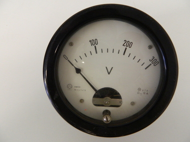
Meter Volt, mid to late 1900's
This analog voltmeter is quite a large (industrial type) apparatus which permits the easy monitoring of electrical variations within the large SEC Victoria Hydro Scheme's electrical generators. These generators are powered by the hydro force of "stored" water at a higher altitude. The establishment of both the NSW and Victorian Hydro schemes was achieved from the mid 1900's to the 1960's. At this point in time the need for additional power sources to quench both an industrial and domestic demand for electricity was purely an economic and not and environmental (carbon reduction) factor. This hydro scheme was instigated by "the Government of the day" as a bold move and was the major force of the World War II refugee and "technical" workforce inclusion of skilled and unskilled migration into the Australian environment. Although this mass "invasion" of workers with families was thought of in some circles as intrusive, the expansion of population post war years and its integration into the Australian rural sector, produced the multi- lingual multi-cultural diversity of later years. This voltmeter is very significant to the Kiewa Valley as its use was introduced during the Kiewa Hydro Scheme. Although only a small apparatus it was part of the explosion of human resources into the valley. This influx of population transformed the region from that of a basically quiet rural region to one which evolved into both an industrial and a larger residential community. This evolution in the valley created a change, not only in the "physical" landscape but also the socio-economic expansion which permitted other "tourist" based industries into the valley. This analog volt meter has two metal rods protruding from the "back" of instrument with screw on points for the negative and the positive leads allowing the "current" to flow across the calibrated resistors to indicate on the "face" side the strength of the voltage "power". The "face" of the instrument has a zero point and then five evenly graduated marks from Zero to the "100, 200 and 300" marked points of measures. A large "V" below these pointers indicates that they represent levels of voltage. Three small screws hold the "face" in place. At the back of the meter is an aluminium "clasp" with three protruding screws (positioning fasteners) and a a screw tightening fixture for the correct fastening of the "clasp" into the correction location on the meter "board".Manufacturer's logo "CSG" underneath "ITALIA"kiewa valley tourism, victorian alps, alternate energy supplies, alpine population growth -
 Kiewa Valley Historical Society
Meter Millivolt, after 1950
This milli-volt meter was manufactured after 1950 and used by the SEC Vic (Kiewa Hydro Electricity Scheme) from that date until late 1900's. It was used to measure very small voltages associated with the operation of the various Hydro Generators. The readings were able to be shown by the resistor in use in the current circuit. During this time period, high quality testing instruments were either sourced from Europe or England.This milli-volt meter is very significant to the Kiewa Valley as it was used by those electrical technicians, who were part of the Kiewa Hydro Scheme. An "off spin" from the Scheme was the beginning of an explosion in "human" resources into the Kiewa Valley. This influx of population transformed the region from that of a basically quiet rural region to one which evolved into both industrial and larger residential community. This evolution in the Kiewa Valley created a change, not only in the "physical" landscape(better roads and infrastructure), but also the socio-economic growth within the Valley allowing other "tourist" based industries to expand within the valley and Alpine areas.This millivolts DC meter was used in the 1950's. It is contained in a wooden box and has two coloured (red/black, positive and negative) screw tight knobs which have bake-lite connections. It also has a covered (black tin) view meter marked from zero to 10 millivolts. Underneath this and within a round bake-lite is a small adjustment screw. The top of the box is fastened onto the main structure by six brass screws. The back of the structure is fastened by eight brass screws and there are four small bake-lite rest knobs.On the face of the millivolt compartment , and at the top "TO BE USED WITH DIAL HORIZONTAL TEMP. COEF. +- .08 % PER oC. Underneath the scale "MILLIVOLTS D.C. F.G." (LEAD RESIS. .05 OHMS)" underneath and to the left "MADE IN ENGLAND BY" "EVERSHED & VIGNOLES Ltd" and to the right "No. 857842" underneath Regd. TRADE MARK MEGGERkiewa valley tourism, victorian alps, alternate energy supplies, alpine population growth -
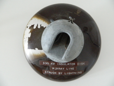 Kiewa Valley Historical Society
Insulator Disk High Voltage, 1964
This insulator disk for the high voltage carrying electrical cables was manufactured in 1964 and used by the SEC Vic (Kiewa Hydro Electricity Scheme) from that date until late 1900's. It was used to connect high voltage cables to their "towers" going from various Hydro Generators to and from power "stations". During this time period, high quality "cable" insulators were manufactured in Japan. In an earlier time they would have been sourced from Europe or England. After the 1950's the sourcing of electrical hardware was being influenced by the lower costs obtainable from Japan. Later on other Asian sources also became available.The need for a mountainous and a large area of operational requirements, such as the SEC Vic Kiewa Hydro Electricity Scheme, to distribute the electricity produced in the Victorian Alps to the major users required power transmission lines to "carry" high above the sometimes inaccessible land mass electricity generated at the power stations to the various sub stations along the valleys and ranges to flatter populated regions. The significance of this insulation "high voltage" disk to the Kiewa Valley region relates to the impact of modern technology (at that time) upon a mainly rural environment. These power lines are a stark visual "show" of the impact that the "Scheme" has on the mostly rural landscape of the Kiewa Valley and what a boost of "modern" equipment into the area has taken place. The "Hydro Scheme" had facilitated the transition of a semi rural area to an advanced rural region within a shorter time frame, than would have taken under "normal" evolutionary time. The speed of information of all "new technology" had a relatively slow assimilation rate before the SEC Kiewa Hydro Scheme came to those living in the then quieter rural communities. This high voltage (330 KV) insulation disk is made from non conductive porcelain stoneware. It is highly polished brown in colour and has a clip fastening for the high voltage cable to be attached to. This disk was hit by lightning and the burn marks are quite noticeable. The top metal connector has a "mushroom" extension jutting below the semi cone like insulation disk. Also four circular ridges or grooves (old 78 rpm disc recording style).Cable bell on top of insulation disk "4K " next to it the international symbol for electricity (triangle containing one horizontal line under one V line and one vertical flame like line.) On the opposite side "2" and to the right "64"sec vic kiewa hydro scheme, alternate energy supplies, alpine (above ground) high voltage electricity cables, volt cable, 330000 volt cable -
 Kiewa Valley Historical Society
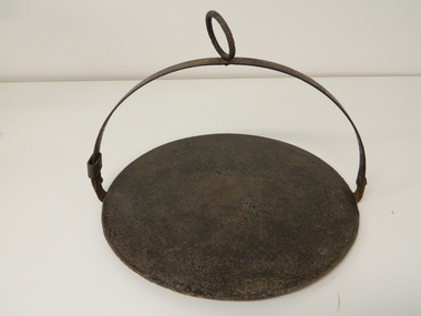
Plate Hot - Camp Fire, circa early 1900s
This "camp fire" hot plate has been used from the early 1900's on camp drafts /droving cattle onto and from the Victorian high plains. The size of "camp" kitchens would depend on the amount of "cattle" men required to collect and move the "herd" to and from the "lush" high plains.This "camp fire" hot plate is significant because it was donated by a member of the Roper family (the Roper's of the Kiewa Valley) a "pioneer" family. This particular camp fire hot plate originated in Tasmania however the Victorian Alps are very similar to the Tasmanian mountain regions and this type of cooking utensil was, and still is, used in isolated regions e.g. large cattle properties in the Northern Territory. This Camp Fire hot plate was used on the High Plains at the Roper Hut for approximately 35 years.This open fire hot plate is made from caste iron. It has a circular flat (cooking) base, ideal for a few thick pieces of prime steak, a high semi circular handle with a large circular carry ring, to apply a thick stick or rod through it as an insulated handle (to position the hot plate where required over a fire). The "handle" can be folded down to save space when packing it in the saddle bags. The handle has a strong metal rivet on each end (is loose enough to allow it to be moved to either side e.g. flattened). One end, of the handle, has a movable sleeve to fasten the the handle in an upright positioncamp fire cooking utensils, hot plate, cast iron cooking appliance, drovers kitchen, cattlemen -
 Kiewa Valley Historical Society
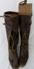
Boots Riding Women's, Circa 1950's
This pair of "adjustable" boots came from the 1950's era in which the majority of footwear was either locally manufactured or imported from England or Europe. Quality hard wearing leather was a rural necessity especially for the cattle mustering activity in the Kiewa Valley and the Bogong High Plains region. The late 1900's provided a cheaper made riding boot from Asia, however many rural based riders still prefer an Australian made boot. The better quality (stronger stitching) of Australian boots is the main considerations of "stock horse riders". In 1947 a scientific research project started to provide an impact analysis of any damage to alpine vegetation by cattle grazing in the Alpine regions incorporating the Bogong High Plains area. This monitoring is the longest running ecological study ever undertaken in Australia. From this study, compelling evidence was presented to the Victorian Government to cease cattle grazing in the Alpine regions including the Bogong High Plains. All grazing was banned by the Victorian Government in 2005. Recreational horse riding within the Bogong High Plains is still permitted.These pair of women's riding boots are very significant to the Kiewa Valley as the boots were worn by one of the descendants of a pioneer family living and operating a cattle station before the SEC Hydro Electricity Scheme opened up the semi remote rural location in the 1950's. These boots were worn during the annual six weeks (approx.) mustering of cattle in the Bogong High Plains location (Victorian Alps region). The owner of these boots was Clare Roper, part of the Roper Family who built a "lodging" hut on the "High Plains" for accommodating riders during the periods (up to six weeks) when controlling grazing cattle during the summer muster seasons. It was unusual for women in the early to mid 1900's to go up on the High Plains to join the muster, which Clare Roper often did. These boots have high historical significance and good interpretive capacity.These brown "knee high" lady riding boots, are fastened by long "boot" laces which go from the base of the "fastening" position to a boot height of 22 cm. At the top end of the boot is a leather flap which crosses the front section of the boot and is fastened to the outside leg region by two straps. These provide the wearer with an adjustable tie. The boot has a "tongue" of 22 mm long. The boot has six pairs of metal boot lace "hooks" and eight pairs of boot lace "eyelets".ladies riding boots. cattle mustering footwear. rural footwear. cattlemen. bogong high plains. roper family. horses. -
 Kiewa Valley Historical Society
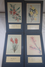
Illustrations of Wildflowers
The Bogong High Plains have many Alpine wild flowers unique to the area.The SECV appointed artists to draw the wild flowers in the Victorian Alps where they were constructing the Kiewa Hydro Electric Scheme.32 illustrated wild flowers each mounted on blue/grey particle board with Botanical and Family name and common name printed underneathalpine wildflowers, alison m. ashby, flora illustrations -
 Kiewa Valley Historical Society
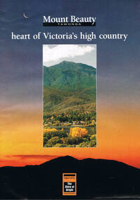
Poster Brochure, Mt Beauty Tawonga Heart Of Victoria's High Country, Circa 1995
The Item is a pictorial time piece of the valley and usage, farms,industry,town area, vegetation and winter snow levels Historical and the social-economical development at circa 1995 of land usage and residential buildings style.Major social events e.g. Festival of the Bogong Moth and the Mt Beauty Mardi Gras. It is also a good historical record of tourism campaigns of the Alpine Shire and Mt Beauty Chamber of Commerce. Also see "KVHS 0125"Brochure folds out from a 20.5cm x 29.5cm to 82cm x 29.5cm poster type documentinside panoramic photo of snow tipped alpine mountain range incorporating the Mount Beauty township, farming area of the Kiewa Valley and relevant tourist orientated informationtourism mt beauty tawonga photographs, victorian alps -
 Kiewa Valley Historical Society
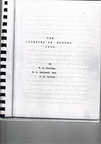
Book - Non Fiction History, The Climbing Of Bogong 1932, 1933
The historical documented account of the first winter traverse from Mt Hotham across Mt Bogong. The extreme winter conditions of the region was a barrier for all except the three pioneers of this expedition.This book details the the determination and true spirit of the Australian psyche to overcome extreme hardships and have the endurance to fulfill an adventure in the early 1900's.A photo copy of a black spiral bound book written in 1933 covering the memoirs and photos of only the first (at the time of writing) winter climbing of Mount Bogong in1932. It was written by Jack K.Tulloh (a journalist), E.C. Robinson and W.D. Bertram. This book was photocopied and rebound for the 60th anniversary of the climb.The Climbing Of Bogong Mountain 1932. First page author's dedication: To Bill from Jack 17/2/1933. Second page address: To jack Eddie & Bill " In recognition of your epic journey 50 years ago" John, Helen, David, Iain, Andrew & Hamish, also written in freestyle underneath and in brackets "Bertrams all" underneath signed by Gwen Tulloh, Barbara Betram and Ann Robinson The third page written in free hand " Inscribed by those who lunched9WELL0 on the golden anniversary of the trip 17/8/82. Next to a photo of the three climbers their signatures.climbing mount bogong, victorian alps in winter, snow at mt bogong 1920's winter sports, skiing, mt bogong, book, snow, cross country skiing -
 Kiewa Valley Historical Society
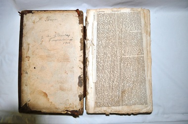
Bible - Family, Brown's Superb Bible, circa early 1800's to 1900
This item represents one of the most important spiritual references available to a settler in countryside Australia in the period 1800s to 1900s. This is the family bible and relates to the major religious beliefs of the early settlers who pioneered British/European colonial settlements. Although the first pages are missing the family name is written on the inside cover (J.A. Fleming). Most of these bibles (of this era) showed the family genealogical record of births, baptism and deaths, however this bible has the relevant pages missing. This bible would have provided the spiritual strength needed in bad times. Throughout this bible there are copies of specially commissioned lithographic engravings, each published between March 1812 to December 1813. These photographs were provided to visualise the theme of the each chapter.This item is significant because it shows that spiritualism of a small group (family in this case) is a vital part of the cohesive forces which holds a family(the basic subgroup of society) together, against all odds, and external pressures. It demonstrates that even in isolated or sparsely populated areas, the mores of a christian community is as strong as that of the cities. Mountains (Victorian Alps) have throughout the enlightened Ages been of extreme spiritual significance and this beholds those who live in this area.The families in the Kiewa Valley fall into the "isolated rural area" when this bible was first in use. This bible contains as its introduction,scripture history starting from 4004 BC "God created all things" to 2900 AD end of the World. There is a high degree of probability that this bible belonged to a member or members of the John Ambrose Flemming extended family who resided in the Kiewa Valley. J.A. Flemming (a famous English electrical engineer and physicist) invented the first diode in 1904). He and his family were devout Christians and he helped establish the Evolution Protest Movement.Leather bound bible. Leather in some areas is in tatters revealing the thick multi-layered cardboard backing. Front and back covers are held together by the thin leather binding. The lettering of the bible is large.Hand written inscriptions are in ink on the inside front cover, " J Tangam" at the top, "J A Fleming" underneath "Tangambalanga" and below that "1900". There are penciled dates "1937 1900" which have at one point in time been scribbled over in pencil. Although not marked on cover, the bible was known as "Brown's Bible" after the Author, the Rev. John Brown. Each of the major chapters is introduced by a copy of a lithographic print detailing the relevant religious picture and all are headed by "Brown's Superb Bible" and the date of the print. bible, rev. john brown, old and new testament, christianity -
 Kiewa Valley Historical Society
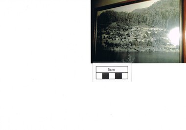
Photograph Bogong, Bogong Township Circa 1950, circa 1940s to 1950s
The Bogong Village was originally constructed (1937-1940) by the State Electricity Commission to house, engineers and construction workers working on the Kiewa Hydroelectric Scheme. These workers were initially settled in 26 houses and were mainly of European heritage. At the completion of the scheme, in the 1960's, the village was opened to public/tourism use. This photograph shows the village before beautification for tourism was introduced and "bare bones" homes and village usage existed.This photo clearly presents a period of restricted human occupation of a very fragile Alpine environment(up to 4000 workmen involved). This was the beginning of a planned and controlled form of sustainable tourist orientated development of the Victorian Alps and high plains region. The Bogong Township was the base camp for workers employed by the State Electricity Commission. After the construction phase was completed, the planning and controls originating from this period have been modified to allow a greater public access of this unique environment.Photograph of a framed glass enclosed black and white photograph of the Bogong settlement Paper details "KodakXtraLife paper" on back of photo. bogong village, bogong township, sec alpine constructions, hydro, kiewa scheme -
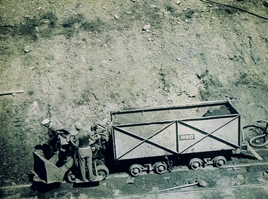 Kiewa Valley Historical Society
Photograph Shovel Truck, Shovel Loading Rail Truck, circa 1950s
This item shows the excavation of the side of a railway track using a pneumatic shovel and a rail mounted truck by two workmen. The period covered was well before State Health and Safety requirements, such as helmets, became law. It also details that the workmen were from European heritage as their head coverings were a handkerchief knotted at each corner. This was typical for workmen of this heritage, others used caps or hats or no head covering at all (the macho male look)The photograph of this item was one of many depicting great achievements and opening up the region. A visual link or time capsule of the 1950s rural/mining sectors clashing with the established rural industriesThis photo depicts the time (1950's) and place (Bogong and Mount Beauty) where construction workers had an immense impact, not only on the physical environment but also on the social and economic development of the Victorian Alps region. The fast expansion of smaller settlements brought about increased pressures on the welfare viability of certain subgroups within the region e.g. farming, droving and commerce (caravan hawkers versus static shops). These changes brought about a heightened awareness by both local and State Governments to upgrade not only facilities within the region but also access to the region. Black and white photo of two workmen on a rail mounted shovel truck. The photo is of good definition allowing a clear view of the subject matter. The paper is semi gloss.On the back of the photo, paper suppliers etchings are "Kodak XtraLife II paper"mining, hydro electricity, victorian alps, construction camps, earth moving machines -
 Kiewa Valley Historical Society
Photograph Clover Dam, Clover Dam Circa 1940, circa 1940s to 1950s
As part of the push to cut electricity costs and diversify supply, the Victorian Government (circa 1930) implemented the conversion strategy from mainly brown coal supply to hydro - electricity. The Kiewa Hydroelectric Scheme became the largest scheme of its kind in the State Of Victoria and the second largest scheme in Australia. This dam was constructed to supply water to feed four turbines (62 mega watts) at the West Kiewa Power Station. This was at the forefront of sustainable "Green" energy. Costs associated with power supplies is still a major incentive of governments, however environmentally friendly alternatives such as wind and nuclear have also made inroads. The Kiewa valley and its surrounding alpine catchment were looked at(Victorian State Government), from the beginning of the twentieth century as a source of alternate power for an every increasing demand for electricity by growing population and heavy industrial ares within Melbourne City and State regions. Construction of dams, such as Clover Dam provided the large quantity holding areas of water required to turn the turbines at the various power stations to provide the electricity needed. The impact of these controls by moderating water run off from the alpine regions is beneficial in reducing flooding from thawing of snow on the alps. This by-product allows agriculture and grazing to be less vulnerable to seasonal flooding thereby resulting in a more stable annual production level.Reproduction (scanned) of a black and white photo of Clover Dam circa 1940. The paper used is KodakXtraLife II paperThe reverse side of photo " KodakXtraLife II paperdams, pondage, hydro electricity, power stations, clover dam, secv -
 Kiewa Valley Historical Society
Mantle for Gas Lantern
Originally these mantles where produced to be used in gas street lights in Europe and North America cities.There use started in 1891. These mantles were used before electrical power street lighting was installed. They have been used ever since until safety concerns regarding radiation from their thorium infused particles made alternate mobile lamps more attractive. The age of open flame recreational lighting is fast coming to a close. The greater use of battery and generator powered lighting(ease of operation) has brought the costing of these alternative lighting to an acceptable level. The age of miniaturisation and volatility of the open flame has seen a greater swing to smaller and more stable lighting. These incandescent gas mantles were initially used in the Coleman White Gas LanternsThe Kiewa Valley, with its closeness to the Victorian Alps, allows greater opportunity for the "happy" campers to enjoy the outdoors. The lighting provided by the incandescent gas lamps allow the adventurer at heart to enjoy an alternative lifestyle and still having the comforts of "home" at their finger tips. The numerous camping facilities in the Kiewa Valley and the upper alpine region is testament that those living in the cities need a break from the day to day grind and go to a quieter and more spiritual environment. Artificial lighting, as provided by mobile apparatus, is highly valued by the urban gypsy. The outdoor recreational industry has significantly provided for, if only at holiday time, an industry that has a relatively high employment rate and beneficial to local communities.The gas mantle is in a fabric, pear shaped, of rayon fabric impregnated with cerium. It's appearance is similar to a very small fishing net. The fabric is very ply-able until it is heated by an open flame then it becomes more rigid and lets out an incandescent white light. Its colour is white to off white. It has a draw string fastened a t the bottom (to wrap around the flame source)lighting, gas, heating, camping, outdoor equipment lamp -
 Kiewa Valley Historical Society
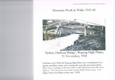
Journal - Reference, Mountain Work and Walks 1945-48,The Joy of Being Alive, circa 1950s
This journal detailing the author and friends walks and observations together with black and white photographs of the Kiewa Valley and the Bogong high plains regions during various "walks during the years 1945 to 1948. These walks were undertaken during the various Hydro - electricity generating plants and infra structures were being installed. It relays how the walker and adventurer enjoyed the pristine Alpine regions of Victoria. The wilderness and higher sense of adventure encountered by the author and his "walking party" is now no longer that intense. The isolation of the region was, at that time, still a barrier for the casual adventurer and required a dedication of the "pioneer" mountain walker.The significance of this journal is that both the photographs and accounts of those intrepid adventurers walking throughout the Victorian Alps and the Bogong High Plains details the countryside in one of the remaining years of relative pristine and minimal "tourist" developed regions of rural Victorian. The necessity of greater electrical power supply to the rapidly growing demand from cities and larger towns, post World War II immigration, had resulted in drastic changes to the infrastructure of the Victorian Alpine regions and particularly the Kiewa Valley. The photographs and the written accounts of the "adventurers" in this journal presents the last phases of the " Australian rough outback environment" and also the typical "bush wise" city/town dweller that although lived in towns and cities still had the adventurers heart of their fore fathers.This item has been photocopied by the author of his journal, consisting 27 pages of A4 size paper. A covering letter by the author is at the front of this loose leafed journal. The journal is bound in a yellow plastic cover with spirals. At the back is a 2 page biography of Myrtle Emily (Grigg) Deamer 1922-2006, then a photo of Meg with baby Bryn and son Tony followed by a letter from David BottomleyThe author's correspondence and covering letter has his signature "D Bottomley"alpine country, bush walking, bogong mountain, alpine adventures -
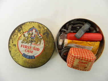 Kiewa Valley Historical Society
Functional object - Pocket First Aid, Circa mid 1900s
This pocket First Aid kit is small and compact which became available to those venturing out in the outback and required an easily managed first aid kit. It was manufactured in the mid 1900s well before vinyl and or plastic pouches or bags where used. It was in an era where valuable items were stored in durable containers due to the harsh and rugged conditions of the Australian bush. Cheaper and less durable containers from Asian manufacturers had been kept out by the heavy Tariff imposed on their goods. This changed in the 1980's when the Tariff Board was dismantled by a then Labour Government. The Australian manufacturing industry was severely reduced by the Influx of cheaper goods. This item was made by an Australian company when the motto "true blue" was the catch cry for quality Australian made goods. This was in the period where the isolation of many rural communities required the basic first aid kits to be of a tougher quality than those offered in large cities and towns.This pocket first aid kit was very compact and would have been easy to carry without taking up too much space for bush walkers, camping scouts, drovers and independent miners and cattlemen. The Kiewa Valley and surrounding rural settlements did not have the medical backup that the larger cities and towns had up until the mid 1900s when the Hydro Electricity Schemes were built and the additional influx of workers made it feasible to have a hospital and better local health facilities. This influx of the construction workers associated with the Hydro Scheme. also brought European workers who where more inclined to go bush walking and climbing the Victorian alps than the average Australian rural worker. This item is a Sanax pocket first aid round tin, gold in colour with red and white print. It's contents are: one small tube of Sanax antiseptic cream, one small one inch x six yards of gauze bandages, rubber band type ligatures with a cast iron tightener., one small tweezers three safety pins, and one lancet.On the lid there are: are outlined white cross on a blue circular background. underneath is a whiite circle encased with a red line with the following printed "Sanax pocket first aid case" (in red print underneath this is a small curved blue background and in black print "No. 26"medicine, first aid tin, camping medical supplies, personal first aid, sanax -
 Bendigo Historical Society Inc.
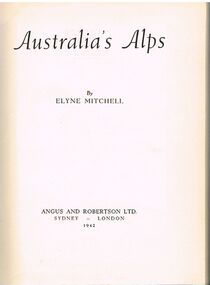
Book - ALEC H CHISHOLM COLLECTION: BOOK ''AUSTRALIA'S ALPS'' BY ELYNE MITCHELL
Book. ALEC H CHISHOLM COLLECTION. 185 page hardcover book by Elyne Mitchell about Australia's Alpine country around Mt Kosciusko. The author was a champion skier. Her book is illustrated with 57 B & W photos mainly of snow clad scenes. Published in 1942 by Angus and Robertson Ltd, Sydney and printed by the Halstead Press, Sydney. Inside flyleaf is a typed letter from the Author to Alec Chisholm thanking him for an excellent review of the book. Next to it is a press cutting of Chisholm's review from the SMH 1 Aug 1942. Catalogue sticker ''2254 MIT'' on spine.Elyne Mitchellbooks, collections, australiana, alec h chisholm collection, elyne mitchell, australian alps -
 Victorian Aboriginal Corporation for Languages
Book, Department of Natural Resources and Environment, Victoria's biodiversity : our living wealth, 1997
Lush colour photographs of the particular environments, including flora, fauna, birds etc and maps locating area.Colour illustrations, colour photographsconservation, sustainability, biodiversity, victorian alps, mallee -
 Clunes Museum
Photograph
Giovanni Brusaschi born in 1827 in Villa de Tirano, Italy. Died 1898, buried in Clunes, Victoria, Australia. Naturalised in 1893. This person is an example of the migration from the Swiss Alps to Clunes as a attractive location for settlement and the raising of his family. Giovanni was one of the district's pioneers.Photograph of Giovanni Brusaschi in ornate frame. Painted silver with floral garland decoration."5 guineas" stamped on back of frame. "MADE IN USA" stamped on back of frame.brusaschi, portrait, swiss italian migration, grape grower, clune's pioneer