Showing 4406 items
matching australian mines
-
 The Beechworth Burke Museum
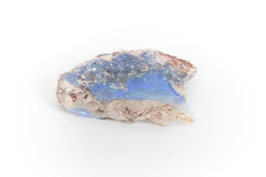
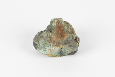
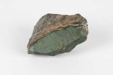
Geological specimen - Precious Opal
In Australia, precious opal is found in Cretaceous age sandstones and mudstones. These sedimentary rocks were deeply weathered and this weathering released silica into the groundwater.Australia is the only part of the world where opalised animal and plant fossils have been found. Opal artefacts several thousands of years old have been discovered in East Africa. As early as 250 BC the Romans prized opals, thought to have come from mines in Eastern Europe, the ancient world's main source of opals. There are many aboriginal dreamtime stories that feature opal. Australian opals discovered during the late 1800's found little favour with European markets but their commercial value increased in the 1900's and in 1932 Australia took over as the major producer of opals in the world and remains the largest producer to this day. Opal is found around the world (Brazil, Mexico, Honduras and the western US) however Australia produces 95% of the world's precious opal and it is our official national gemstone. Opal was first mined commercially at Listowel Downs in Queensland in 1875 and later at White Cliffs in NSW. Today, Coober Pedy (SA) is the main producer of white opal, though in recent years this field has expanded and all types of opals are found. Other centres in SA include Andamooka and Mintabe. Lightning Ridge (NSW) is renowned for black opal and formerly White Cliffs was a large producer of high quality opal. Boulder opals (opals in concretionary ironstone) are mined in Queensland from numerous localities in a zone extending from the Eulo and Cunnamulla district in the south and northwest for a distance of over 700 km to Kynuna in the north. The towns of Quilpie, Yowah and Winton are the main opal mining and wholesale centres. Opals are considered gemstones and have been used in jewellery for thousands of years.Throughout much of history, opals were actually believed to be good luck. The Romans thought that opals were one of the luckiest gemstones and a symbol of hope. In the Middle Ages, opals were believed to be bestowed with all the positive properties of coloured gemstones due to its rainbow-like play of colour. Finally, there is a superstition that you should not wear an opal unless it is your birthstone otherwise misfortune will befall you. This, of course, is far-fetched, but the notion could have been promoted in the late 19th and early 20th Centuries by diamond traders who were trying to increase sales of diamonds and deter people from buying opals. Possibly related to this is the thought that you should set opal jewellery with diamonds as their powers of good fortune will override any negativity held by the opal. The great majority of opal does not show play of colour and is called common opal or potch however this is not the case with a precious opal. Opal is a precious gemstone, like rubies, emeralds or diamonds. Opal is rare, and it is expensive to prospect and mine for.Silica is one of the most common minerals on the planet, but precious opal is very rare – far more rare than diamonds. Precious opal is rare because the natural processes that create it rarely occur.Most (at least 95%) of the opal found by miners is common opal without gem colour. In Australia we call it potch. It can be white, grey, black or amber coloured. Even when a miner finds gem-coloured opal, most of it can’t be cut into gemstones because it’s too thin, or sandy. This specimen is part of a larger collection of geological and mineral specimens collected from around Australia (and some parts of the world) and donated to the Burke Museum between 1868-1880. A large percentage of these specimens were collected in Victoria as part of the Geological Survey of Victoria that begun in 1852 (in response to the Gold Rush) to study and map the geology of Victoria. Collecting geological specimens was an important part of mapping and understanding the scientific makeup of the earth. Many of these specimens were sent to research and collecting organisations across Australia, including the Burke Museum, to educate and encourage further study.It is not known where this opal originated, except that it is probably from Victoria, as it has been recorded from many localities in the State. Common Opal is formed from silica-rich water circulating through rocks near the Earth’s surface. It consists of minute spheres of silica arranged in different ways. In common opal, the spheres are of different sizes and randomly arranged, unlike in precious opal where the spheres are of similar size and uniformly arranged in three dimensions. These differences account for common opal generally being translucent to opaque and without the play of colours, or opalescence, displayed by precious opal. Common opal is found in many localities and different geological environments throughout Australia and the world. Precious opal requires special conditions to form and is much less common. Australia produces most to the world’s precious opal. burke museum, beechworth, indigo shire, beechworth museum, geological, geological specimen, precious opal, opal, brazil, mexico, honduras, queensland, coober pedy, gemstones, jewellery, play-of-colour, light blue -
 The Beechworth Burke Museum
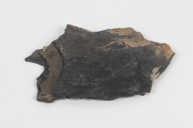
Geological specimen - Chalcopyrite
This specimen originated from Mount Lyell on the west coast of Tasmania, where a large group of open cut and underground copper-silver-gold mines began operating in 1883. Between 1893-1994, the Mt Lyell Mining and Railway Company were responsible for operations. The Mt Lyell copper-gold mines produce some excellent crystallised specimens of chalcopyrite and other minerals. The deposits are generally considered to be of Cambrian volcanic origin, but there are indications of Devonian granitic influence on the ores, plus local remobilisation during Devonian deformation. Over 120 million tonnes of ore was produced from several workings, including the main Prince Lyell mine and the North Lyell mine, which was also of great importance. The Mount Lyell mines have a long history of human and environmental disasters, including the 1912 North Lyell fire that killed 42 miners, and two separate incidents in 2013 in which three people lost their lives. The environmental impacts from this complex of mines are extensive, with waste tailings and heavy metal contamination flowing directly into the King and Queen River catchments. In 1954, the eminent Australian historian, Geoffrey Blainey, published 'The Peaks of Lyell' which delves into the history of the 1912 North Mount Lyell Disaster.Chalcopyrite does not contain the most copper in its structure relative to other minerals, but it is the most important copper ore since it can be found in many localities and occurs in a variety of ore types. The brassy-yellow colours in Chalcopyrite mean it is often confused with pyrites and gold, leading to use of the term, "fool's gold." Chalcopyrite has been the primary ore of copper since smelting began five thousand years ago. This specimen is part of a larger collection of geological and mineral specimens collected from around Australia (and some parts of the world) and donated to the Burke Museum between 1868-1880. A large percentage of these specimens were collected in Victoria as part of the Geological Survey of Victoria that begun in 1852 (in response to the Gold Rush) to study and map the geology of Victoria. Collecting geological specimens was an important part of mapping and understanding the scientific makeup of the earth. Many of these specimens were sent to research and collecting organisations across Australia, including the Burke Museum, to educate and encourage further study.This hand sized solid mineral specimen has shades of brass-yellow with spots of iridescent green-black tarnish. Chalcopyrite is a copper iron sulphide mineral and a major ore of copper common in sulphide veins and disseminated in igneous rocks. Chalcopyrite has a hardness of 3.5-4 on the Mohs Scale. It is a member of the tetragonal crystal system and has metallic lustre and opaque transparency.burke museum, beechworth, indigo shire, beechworth museum, geology, geological specimen, chalcopyrite, copper pyrites, copper mining, tasmanian geology, mount lyell, mount lyell mines, fools gold, mohs scale, crystals, minerals, historical geological collection, victorian geological survey, a.r.c selwyn, gold rush, van diemans land -
 The Beechworth Burke Museum
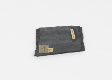
Geological specimen - Slate (Metamorphic), Unknown
... . However, its history of being mined in Australia is not common ...This particular specimen was found in the Moorabool Slate quarries in Victoria. The Moorabool Slate quarries was established in the 1860’s by a company of Welshmen with a crew of six who purchased land by the riverside to mine for slate. Under the promise of adding to existing recourses the crew mined the slate which was used for paving and roofing. Slate is a fine-grained, low-grade metamorphic rock that is formed by the transformation of mudstone, shale or sometimes volcanic ash under low pressure and temperatures. It dark colour is due to carbonaceous material or to finely divided iron sulphide. It is believed that Evan Rowlands and Theophilus Williams of Ballarat were the first to discover the slate veins. Slate is a one of the most common natural stones in general use. Being used as paving, flooring, roofing and more. However, its history of being mined in Australia is not common as it is considered that the best places to mine slate is Spain and parts of the United Kingdom. This specimen is part of a larger collection of geological and mineral specimens collected from around Australia (and some parts of the world) and donated to the Burke Museum between 1868-1880. A large percentage of these specimens were collected in Victoria as part of the Geological Survey of Victoria that begun in 1852 (in response to the Gold Rush) to study and map the geology of Victoria. Collecting geological specimens was an important part of mapping and understanding the scientific makeup of the earth. Many of these specimens were sent to research and collecting organisations across Australia, including the Burke Museum, to educate and encourage further study.A somewhat rectangular foliated metamorphic rock composed of quartz, sericite and minerals from the chlorite group that make up the compounds of slate. The rock is dark grey almost black.Geological survey / R S / Loc Moorabool /Slate quarries / 1/4 sheet | 78 | Roofing Slate /burke museum, beechworth, geological, slate, metamorphic, slate (metamorphic), geological specimen, slate specimen, indigo shire -
 The Beechworth Burke Museum
Geological specimen - Basalt (igneous-volcanic) containing Olivine, unknown
This particular geological specimen was found in Mount Franklin or Lalgambook in Djadjawurrung, located between Daylesford and Newstead, approximately ninety minutes drive from Melbourne. The mountain is an example of a breached scoria cone (a steep conical hill of loose pyroclastic fragments) which was created by a volcanic eruption about 470,000 years ago, a date which may indicate the age of this geological specimen. The volcanic eruptions of Mount Franklin were most likely witnessed by members of the Dja Dja Wurrung Aboriginal tribe, who referred to this country as the 'smoking grounds'. Mount Franklin and the surrounding area appears to have been a place of considerable religious significance to Aboriginal people, there is evidence which indicates that frequent large ceremonial gatherings took place in the area. Basalt is the most common rock on Earth’s surface, more than 90% of all volcanic rock on Earth is basalt. Basalt is an aphanitic extrusive igneous rock formed from the rapid cooling of low-viscosity lava exposed at or very near the surface of a rocky planet or moon. Specimens are black in colour and weather to dark green or brown. Basalt is rich in iron and magnesium and is mainly composed of olivine, pyroxene, and plagioclase. Olivine is the name of a group of rock-forming silicate minerals with compositions ranging between Mg2SiO4 and Fe2SiO4. Unlike other minerals, Olivine has a very high crystallisation temperature which makes it the first of the minerals to crystallise from magma. As magma cools, the crystals begin to form and settle on the bottom of the lava and form basalts that are abnormally enriched in olivine in the lower part of lava flows. According to H. M. King (on geology.com) "Olivine is thought to be an important mineral in Earth's mantle. Its presence as a mantle mineral has been inferred by a change in the behaviour of seismic waves as they cross the boundary between Earth's crust and mantle". Lava from Mount Franklin and other volcanoes in the area filled valleys and buried the gold bearing streams that became the renowned ‘deep leads’ of the gold mining era. In 1852, as part of the Victorian gold rush, gold was discovered in the immediate area, this gold was created by lava flows during the Newer Volcanic period, which were mined intensively during the nineteenth century. Around 1865 the presence of a deep lead in Mount Franklin was established. Deep lead mining was initially unsuccessful, and it was not until the late 1870s that the Franklinford Gold Mining Company mined at Mount Franklin on a significant scale. A few years later the Mount Franklin Estate Gold Mining Company also struck gold, followed by the Shakespeare and Great Western companies in the mid-1880s. By the late 1880s, however, deep lead mining had ceased in the area. Soon after gold was discovered in 1851, Victoria’s Governor La Trobe wrote to the Colonial Office in London, urging ‘the propriety of selecting and appointing as Mineral Surveyor for this Colony a gentleman possessed of the requisite qualifications and acquaintance with geological science and phenomena’. Alfred Selwyn was appointed geological surveyor in Australia in 1852 which began the Geological Survey of Victoria. In 1853-69 the Geological Survey issued under Selwyn's direction sixty-one geological maps and numerous reports; they were of such high standard that a writer in the Quarterly Journal of the Geological Society of London bracketed the survey with that of the United States of America as the best in the world. During his years spent in Australia, Selwyn collected numerous significant geological specimens, examples of which are held in collections such as the Burke Museum.This geological specimen is an example of basalt and olivine which shows the volcanic lava activity and geographical specific nature of Mt Franklin as a significant volcanic site. According to Agriculture Victoria 'The crater is one of the deepest in the Central Highlands area. It is a major megacryst site with some of the largest known Victorian examples of megacrysts of augite and an orthoclase. The small parasitic mound of Lady Franklin on the western flanks adds to the geological interest of the site'. This specimen also highlights the locality as a significant place for both indigenous activity and Victorian gold rush era mining practices. This specimen is part of a larger collection of geological and mineral specimens collected from around Australia (and some parts of the world) and donated to the Burke Museum between 1868-1880. A large percentage of these specimens were collected in Victoria as part of the Geological Survey of Victoria that begun in 1852 (in response to the Gold Rush) to study and map the geology of Victoria. Collecting geological specimens was an important part of mapping and understanding the scientific makeup of the earth. Many of these specimens were sent to research and collecting organisations across Australia, including the Burke Museum, to educate and encourage further study.An angular, solid hand-sized piece of grey volcanic Basalt with green/brown Olivine phenocrysts along one flat edge.Olivine in basalt / - label is probably / correct. / C. Willman / 15/4/21burke museum, beechworth, indigo shire, beechworth museum, geological, geological specimen, mineralogy, basalt, igneous rock, igneous-volcanic, volcanic geology, volcanic, olivine, olivine specimen, basaltoid -
 The Beechworth Burke Museum
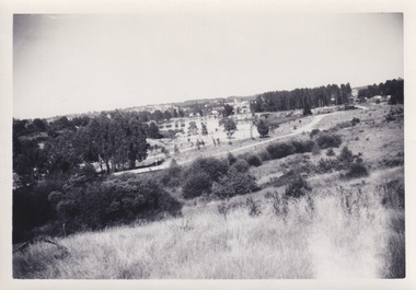
Photograph, 1960s
This photo was taken in the 1960s from a northeast position looking down towards Lake Sambell, the caravan park, and the surrounding area. This photo was taken during a period of rejuvenation for the lake area including the opening of the caravan park in 1959 and the swimming pool area in 1961 (this pool is just visible in the centre of the photo). The popularity of caravanning in Australia exploded during this post-war period of the late 1950s and 1960’s. This popularity was driven by multiple factors, including: the stopping of fuel rations, the accessibility of car ownership through the manufacturing of affordable cars, technological developments in caravan design, and the increase in prosperity and leisure time for many Australians. Lake Sambell is an artificial lake that was developed on the previous site of the Rocky Mountain Mining Company workings and was officially opened by Minister for Lands, Mr Baily, on October 5, 1928. The disused and unattractive remains of the mine were converted into a recreational area intended for swimming, boating, and fishing. The lake is named after Mr L.H. Sambell, shire engineer and secretary of the Forward Beechworth Committee, who advocated for the enhancement of Beechworth into a tourist destination and was central to the planning and establishment of the lake. Funding for the project was raised by both competition funds and donations. Since the construction in 1928 several engineering issues have arisen. In 1939 the water levels were low, and the lake was considered both an eyesore and ‘mudhole’, Beechworth Shire Council sort funding to raise the height of the lake six feet to improve the quality of water. Throughout the 1940s the Beechworth Swimming Club tried to raise awareness and funds to address the structural engineering issues and improve swimming facilities at the lake. R.E. Carter, similar to L.H. Sambell, was a shire engineer who advocated the importance of positioning Beechworth as a tourist destination. Carter held the position from 1954-63 and organised many improvements to the Lake Sambell area including the caravan park in 1959, the lake swimming pool in 1961, water skiing and boating facilities, and increased the lake surface are in 1964. These improvements were financed mainly by grants from the Tourist Development Authority. This photograph is of historical significance as it documents Lake Sambell and the surrounding area in the 1960s after a phase of enhancements to improve the appearance and usability for both the people of Beechworth and tourists. It is also of social significance in providing an insight into the increase in leisure time and access to travel during a period of post-war prosperity.Black and white rectangle photograph printed on matte photographic paper and unmounted.Reverse: 1 / [logo KODAK/ VELOX/ PAPER] / C798 / 3535lake sambell, lake sambell caravan park, lake sambell swimming pool, caravan park, caravanning 1960s, rocky mountain mining company, l.h. sambell, r.e. carter, beechworth swimming club, forward beechworth committee, minister of lands, tourist development authority, lake swimming, swimming, boating, fishing, water skiing, beechworth 1960s, lake sambell fishing, lake sambell boating -
 The Beechworth Burke Museum
Photograph, 1960s
This photograph was taken in the 1960s at Lake Sambell Caravan Park and visible in the photograph are individual caravan sites with electricity outlets, a large single-story building with a caravan park banner, dirt roads, a freestanding message board, and a parked car. Lake Sambell Caravan Park opened in 1959 owing to the work of R.E. Carter, Beechworth Shire engineer from 1954-63. Carter advocated for improvements to the lake and surrounding area in order to encourage tourism in Beechworth. The opening of the caravan park was part of many improvements to Lake Sambell made in this period by Carter including: the swimming pool in 1961, water skiing and boating facilities, and increased lake surface in 1964. These improvements were financed mainly by grants from the Tourist Development Authority. The popularity of caravanning in Australia exploded during this post-war period of the late 1950s and 1960s. This popularity was driven by multiple factors, including: the stopping of fuel rations, the accessibility of car ownership through the manufacturing of affordable cars, technological developments in caravan design, and the increase in prosperity and leisure time for many Australians. Facilities such as electrical outlets to power caravans are present in this photograph of Lake Sambell Caravan Park. Lake Sambell is an artificial lake that was developed on the previous site of the Rocky Mountain Mining Company workings and was officially opened by Minister for Lands, Mr Baily, on October 5, 1928. The disused and unattractive remains of the mine were converted into a recreational area intended for swimming, boating, and fishing. The lake is named after Mr L.H. Sambell, shire engineer and secretary of the Forward Beechworth Committee, who advocated for the enhancement of Beechworth into a tourist destination and was central to the planning and establishment of the lake. This photograph is of historical and social significance in providing insight into caravanning during the 1960s in Australia. Caravanning was extremely popular during the 1960s in Australia due to multiple social and economic factors including the stopping of fuel rations, the accessibility of car ownership through the manufacturing of affordable cars, technological developments in caravan design, and the increase in prosperity and leisure time for many Australians.Black and white rectangle photograph printed on photographic paper and unmounted.Reverse: 3536/ [logo back printing: KODAK/ VELOX/ PAPER] / C798 lake sambell caravan park, lake sambell, caravanning 1960s, caravan park, rocky mountain mining company, kodak velox paper, r.e. carter, l.h. sambell, caravan electricity outlets, tourist development authority, post-war prosperity, forward beechworth committee, lake sambell boating, lake sambell swimming pool, lake sambell fishing, artificial lake, travel 1960s, recreation 1960s -
 The Beechworth Burke Museum
Photograph, 1960s
This photograph was taken in the 1960s at Lake Sambell Caravan Park, visible in the photograph are individual caravan sites with electricity outlets, a large single-story building, a parked car, and two caravans partially obstructed by trees. Lake Sambell Caravan Park opened in 1959 owing to the work of R.E. Carter, Beechworth Shire engineer from 1954-63. Carter advocated for improvements to the lake and surrounding area in order to encourage tourism in Beechworth. The opening of the caravan park was part of many improvements to Lake Sambell made in this period by Carter including: the swimming pool in 1961, water skiing and boating facilities, and increased lake surface in 1964. These improvements were financed mainly by grants from the Tourist Development Authority. The popularity of caravanning in Australia exploded during this post-war period of the late 1950s and 1960s. This popularity was driven by multiple factors, including: the stopping of fuel rations, the accessibility of car ownership through the manufacturing of affordable cars, technological developments in caravan design, and the increase in prosperity and leisure time for many Australians. Facilities such as electrical outlets to power caravans are present in this photograph of Lake Sambell Caravan Park. Lake Sambell is an artificial lake that was developed on the previous site of the Rocky Mountain Mining Company workings and was officially opened by Minister for Lands, Mr Baily, on October 5, 1928. The disused and unattractive remains of the mine were converted into a recreational area intended for swimming, boating, and fishing. The lake is named after Mr L.H. Sambell, shire engineer and secretary of the Forward Beechworth Committee, who advocated for the enhancement of Beechworth into a tourist destination and was central to the planning and establishment of the lake. This photograph is of historic and social significance in documenting the enhancement of the Lake Sambell area overseen by R.E. Carter and providing insight into caravanning during the 1960s in Australia. Caravanning was extremely popular in Australia during the late 1950s and 60s due to multiple social and economic factors including the stopping of fuel rations, the accessibility of car ownership through the manufacturing of affordable cars, technological developments in caravan design, and the increase in prosperity and leisure time for many Australians. Black and white rectangle photograph printed on photographic paper and unmounted.Reverse: 3538/ [logo back printing KODAK/ VELOX/ PAPER] / C798lake sambell caravan park, lake sambell, lake sambell 1960s, lake sambell fishing, lake sambell boating, lake sambell swimming pool, r.e. carter, l.h. sambell, tourist development authority, caravanning 1960s, caravan electricity outlets, caravan park, forward beechworth committee, rocky mountain mining company, lake caravan park, caravan mid 20th century, beechworth tourism, travel in the 1960s, holiday 1960s -
 The Beechworth Burke Museum
Photograph, c1960
The photograph depicts a view across the water at Lake Sambell. The image is thought to date from the 1960s so may show the lake during a period of drought, such as that experienced across South-Eastern Australia in 1967. The present day park and reserve occupies the site of the former Rocky Mountain Mining Company, an open-cut sluice mine that began operations in the mid-Nineteenth Century and operated until the early 1900s, through the peak of Victoria’s Gold Rush. It was converted into a park and leisure area in the 1920s. Lake Sambell was formally opened to the public on Friday 5th October 1928 and was opened by the Victorian Government’s Minister of Lands, Mr Bailey, as part of initiatives to boost the economies and development of country towns. The lake was named after Mr L.H. Sambell, a shire engineer and secretary of the Forward Beechworth Committee who was involved in promoting the transformation of the mining site and promoting plantation forestry and tourism as alternative industries. £300 to begin the process was provided by Mr J. McConvill, a former resident of Beechworth, who is remembered in a street name adjacent to the lake. Residents of Beechworth have worked to raise funds to improve the Lake Sambell reserve several times, such as efforts in the 1930s and 1940s to raise the banks several feet to deepen the water for swimming purposes. Fundraising campaigns include the ‘Ugly Man’ competition conducted on behalf of the Wallace Park-Lake Sambell Development Scheme. The latter competition was run by the Fire Brigade Bend’s team as part of a larger competition called the ‘Mile of Pennies’; it was won by Mr Len Knight of Beechworth’s Commercial Hotel. The ‘Mile of Pennies’ was conducted at a Carnival held on New Year’s Eve, 1947. It was proposed by the Beechworth and District Progress Association. As well as improving swimming facilities, funds were raised to install a caravan park facility near the lake. Funds were also donated by commercial entities, such as £250 received from Zwar Bros. Pty Ltd.The photograph is significant as it shows Lake Sambell at lower water levels, such as may have been experienced during period of drought.Sepia rectangular photograph printed on matte photographic paperObverse: nil Reverse: 3470beechworth, beechworth lake, lake sambell, lake, beechworth and district progress association, forward beechworth committee, ugly man, mile of pennies, wallace park lake sambell development scheme, wallace park-lake sambell development scheme, zwar bros, zwar, l.h. sambell, j. mcconvill, minister of lands, commercial hotel, len knight, rocky mountain mining company, rocky mountain mining co, gold rush, redevelopment, transformation, community fundraising, drought, 1967, 1960s -
 The Beechworth Burke Museum
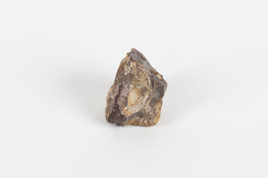
Geological specimen - Common Opal, unknown
Common Opal is a mineraloid that is non crystallising and is classed as an amorphous silicate, the chemical composition for Opal is SiO2 nH2O. Opals can develop in weathered sedimentary rock typical in arid regions where limited water enters small gaps in the rock, and the silicate is hydrated. Common opals, unlike precious opals, do not exhibit ‘play of colour’ in which the colour appears to change depending on the angle of view. While precious opals are highly valuable and cut as gemstones for jewellery, common opals can be cut into inexpensive gemstones and are also mined for various uses including as ingredients in ceramics, insulation, fillers, and abrasives. The source of this common opal specimen is unknown, but common opals are found around the world, notable deposits are found in Queensland, South Australia, New South Wales, Peru, Kenya, Nevada, Oregon, and Mexico. This common opal specimen is of historic and scientific significance due to its donation in 1868 as part of the Geological Survey of Victoria and as a typical example of uncut common opal. This specimen is part of a larger collection of geological and mineral specimens collected from around Australia (and some parts of the world) and donated to the Burke Museum between 1868-1880. A large percentage of these specimens were collected in Victoria as part of the Geological Survey of Victoria that begun in 1852 (in response to the Gold Rush) to study and map the geology of Victoria. Collecting geological specimens was an important part of mapping and understanding the scientific makeup of the earth. Many of these specimens were sent to research and collecting organisations across Australia, including the Burke Museum, to educate and encourage further study.A palm-sized amorphous (non-crystallising) hydrated silicate mineraloid specimen in shades of brown, orange, and white.Existing label: Common Opal / Locality unknowngeological specimen, geology, geology collection, burke museum, beechworth, common opal, opal, mineraloid, amorphous silicates, hydrated silicate -
 The Beechworth Burke Museum
Geological specimen - Dolomite
Dolomite is a mineral, calcium magnesium carbonate, with the chemical formula CaMg(CO3)2. It is a principle component of various rock types sometimes also referred to as dolomite, including dolostone, dolomitic marble and dolomitic limestone (according to the composition of each type). Dolomite rock is found in sedimentary basins throughout the world, comprising approximately 2% of the Earth's crust. It is formed when lime mud or limestone encounters groundwater containing magnesium. Dolomite can contain elements such as lead, zinc and copper. Dolomite and limestone are used in various construction, landscaping and agricultural processes. This specimen was donated to the Burke Museum in 1868 by Alfred Selwyn as part of the Geological Survey of Victoria. It was donated to the Museum in 1868. Victoria and other regions of Australia were surveyed for sites of potential mineral wealth throughout the 19th Century. The identification of sites containing valuable commodities such as gold, iron ore and gemstones in a locality had the potential to shape the development and history of communities and industries in the area. The discovery of gold in Victoria, for instance, had a significant influence on the development of the area now known as 'the goldfields', including Beechworth; the city of Melbourne and Victoria as a whole. Dolomite and limestone are mined at several locations in Victoria, including sites in the North-East of the state in Bindi and Limestone Creek. There are notable dolomite deposits in most Australian states. The dolomitised form of the mineral tends to come from older limestone deposits, formed during the palaeozoic era in marine settings, so this specimen may have come from a deposit located along a coastline in Victoria or another state. The specimen is significant as an example of surveying activity undertaken to assess and direct the development of the mineral resource industries in Victoria and Australia, as well as the movement to expand human knowledge of earth sciences such as mineralogy and geology in the nineteenth century. This specimen is part of a larger collection of geological and mineral specimens collected from around Australia (and some parts of the world) and donated to the Burke Museum between 1868-1880. A large percentage of these specimens were collected in Victoria as part of the Geological Survey of Victoria that begun in 1852 (in response to the Gold Rush) to study and map the geology of Victoria. Collecting geological specimens was an important part of mapping and understanding the scientific makeup of the earth. Many of these specimens were sent to research and collecting organisations across Australia, including the Burke Museum, to educate and encourage further study.Hand-sized piece of pale pink dolomite (calcium magnesium carbonate) with dark grey rim and hollowed centre. geological specimen, geology, geology collection, burke museum, beechworth, dolomite, mineralogy, geological survey, alfred selwyn, limestone, calcium magnesium carbonate -
 The Beechworth Burke Museum
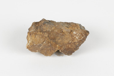
Geological specimen - Kaolin, unknown
Kaolin is also known as china clay. This specimen came from Dunolly, Victoria and was donated to the Museum in 1868 as part of the Geological Survey of Victoria. This survey helped map and study the geology of Victoria. In Victoria, Kaolin is particularly used as a filler and coating material in paper manufacture. It can also be used in paints, ceramics, rubbers and plastics. There are many kaolin deposits in Victoria but many of these have been mined out and there is not much Kaolin left. Rocks that have a high amount of Kaolinite and it can be formed through the decomposition of other materials. There are two types of Kaolin; hard and soft kaolin. Soft kaolin's are coarse but have a soapy texture. It can also break easily. The hard kaolins have an earthly texture and are finer grained. This means that they are harder to break, unlike the soft kaolin. Hard kaolin's are formed by flocculation in salt water, a process that in basic terms, bonds particles together. Kaolin is a common material in Victoria and that is why it is significant. While this specimen was mined in Dunolly, Victoria Kaolin can also be found Pittong, Pakenham, Bulla, Hallam and Ballarat as well as many other places throughout Victoria. This specimen represents the presence of Kaolin deposits in this region of Australia. It is also significant because Kaolin has many uses and is largely beneficial to many manufacturing processes in Victoria. This specimen is part of a larger collection of geological and mineral specimens collected from around Australia (and some parts of the world) and donated to the Burke Museum between 1868-1880. A large percentage of these specimens were collected in Victoria as part of the Geological Survey of Victoria that begun in 1852 (in response to the Gold Rush) to study and map the geology of Victoria. Collecting geological specimens was an important part of mapping and understanding the scientific makeup of the earth. Many of these specimens were sent to research and collecting organisations across Australia, including the Burke Museum, to educate and encourage further study.Two pieces of Kaolinite mineral with shades of white and graygeological specimen, geology, geology collection, burke museum, beechworth, kaolin, china clay, dunolly, geological survey of victoria, kaolinite, victoria, mining, mining deposits, geology of victoria, australia, filler, coating material, paper manufacture, paint, ceramics, rubbers, plastics, decomposition, materials, soft kaolin, hard kaolin, flocculation, particles, salt water -
 The Beechworth Burke Museum
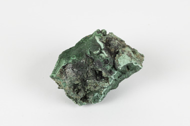
Geological specimen - Malachite, unknown
Malachite is a water soluble, crystalline, triphenyl methylene chloride salt. It has a close relationship to copper because it is common for Malachite and copper to come from the same ore. Malachite often has shades of green, making it also known as Malachite Green. As a result of it's colour, it is known for being a dye and has been used in the dye industry, the textile industry and in medical fields. Cobar in New South Wales is well known for it's mining. This is because of the number of important deposits present in the area and include three important mining belts where most of the materials are found. These are the 'Cobar belt', the 'Canbelego belt' and the 'Girilambone belt'. The 'Cobar belt' runs underneath the main town. Copper was first discovered in Cobar in 1869 and since then, many deposits of other materials have been found, including Malachite.This specimen is significant because it comes from Cobar, NSW and represents the many deposits of materials found there. Cobar has a long history of mining and is a source of Australia's copper minerals. Malachite is often found in copper deposits meaning that it is representative of Cobar's copper production. Malachite is known for it's vivid green colour and as a result, has many uses, such as meaning used as a dye. This makes it a valuable material and highly significant. This specimen is part of a larger collection of geological and mineral specimens collected from around Australia (and some parts of the world) and donated to the Burke Museum between 1868-1880. A large percentage of these specimens were collected in Victoria as part of the Geological Survey of Victoria that begun in 1852 (in response to the Gold Rush) to study and map the geology of Victoria. Collecting geological specimens was an important part of mapping and understanding the scientific makeup of the earth. Many of these specimens were sent to research and collecting organisations across Australia, including the Burke Museum, to educate and encourage further study.A solid hand-sized mineral with shades of brown , white and light green throughout.geological specimen, geology, geology collection, burke museum, beechworth, malachite, copper, water soluble, cobar, cobar mines, cobar mining, cobar nsw, nsw, new south wales, mining belts, ore, copper ore, malachite green, dye, green, dye industry, textile industry, desposits, canbelego, girilambone, alfred selwyn -
 The Beechworth Burke Museum
Geological specimen - Oil shale
This particular specimen is found in Wolgan Valley, New South Wales. It could be linked to the abandoned oil shale mining sites in Wolgan Valley such as Newnes. Newnes was an industrial complex operational in the early 20th century is now partly surrounded by Wollemi National Park. It produced motor spirit, kerosene, and gas oil. Newnes's Torbanite oil shale rock contained around 350 litres of oil shale per tonne. The Torbanite was mined by the Commonwealth Oil Corporation Ltd. Oil shale is a sedimentary rock and also a form of fossil fuel. It is often formed millions of years ago and usually contain fossilised remains of plants and/or animals. Oil shale is rich in kerogen that releases hydrocarbon when heated. These hydrocarbon can be used as an alternative petroleum or natural gas. The oil-shale rock was converted into oil by "destructive distillation"; the rock being heated until it broke down to form an oily vapour and an ash residue. Oil bearing shale is one of Australia's national assets. There are many oil companies established in Australia. It reflects Australia's rich natural resources as well as connection to the Australia's engineering and oil industry. The booming oil shale extraction businesses can be traced as far back as 1920s. This specimen is part of a larger collection of geological and mineral specimens collected from around Australia (and some parts of the world) and donated to the Burke Museum between 1868-1880. A large percentage of these specimens were collected in Victoria as part of the Geological Survey of Victoria that begun in 1852 (in response to the Gold Rush) to study and map the geology of Victoria. Collecting geological specimens was an important part of mapping and understanding the scientific makeup of the earth. Many of these specimens were sent to research and collecting organisations across Australia, including the Burke Museum, to educate and encourage further study.Piece of dark gray oil bearing shale with shades of light brown and fossilised leavesExisting label: OIL BEARING SHALE with / FOSSILISED LEAVES / Locality: Wongan Valley, NSW / Donor: Miss M. Cambell geological specimen, geology, geology collection, burke museum, beechworth, oil shale, shale, fossil fuels, alfred selwyn, wolgen valley, 1868 geological survey of victoria, rocks, sedimentary rocks, newnes, torbanite, commonwealth oil corporation ltd -
 The Beechworth Burke Museum
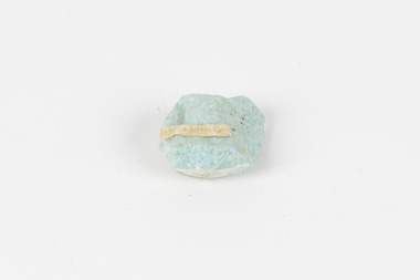
Geological specimen - Amazonite, unknown
Amazonite is classed as a Tectosilicate and is part of the Feldspar group of minerals. Amazonite forms in a triclinic crystal structure and its chemical formula is K(AlSi3O8). In appearance, Amazonite can range from shades of green to green blue to blue, and often with white streaks or veining. The greenish colour is believed to come from the small amount of lead contained in its composition. Amazonite is named after the Amazon River due to its colour and similarities to another rock found along the riverbanks, although Amazonite is not actually found at or near the Amazon. Although less commonly used in jewellery today, Amazonite has been mined and used by humans for thousands of years and Amazonite jewellery from at least 2000BCE have been discovered in North Africa. Amazonite is found in many locations around the world including Brazil, Peru, Ethiopia, Canada, Russia, Mozambique, Myanmar, Pakistan, China, Madagascar, and the United States of America. This specimen most probably comes from the U.S.A., Amazonite is found in several US states particularly in Colorado, Virginia, Pennsylvania. This specimen is of both scientific and historic significance as a striking blue green example of Amazonite mined prior to 1868 in the United States of America, most likely from Colorado, Virginia, or Pennsylvania. These three states are all locations of significant Amazonite deposits. This specimen is part of a larger collection of geological and mineral specimens collected from around Australia (and some parts of the world) and donated to the Burke Museum between 1868-1880. A large percentage of these specimens were collected in Victoria as part of the Geological Survey of Victoria that begun in 1852 (in response to the Gold Rush) to study and map the geology of Victoria. Collecting geological specimens was an important part of mapping and understanding the scientific makeup of the earth. Many of these specimens were sent to research and collecting organisations across Australia, including the Burke Museum, to educate and encourage further study.A palm-sized Feldspar mineral specimen from the Tectosilicate class in shades of blue-green with white veining.Existing label: green/blue Feldspar / "amazonite" / possibly USA geological specimen, geology, geology collection, burke museum, beechworth, tectosilicate, amazonite, feldspar, triclinic crystal structure, amazonite usa, amazonite colorado, amazonite virginia, amazonite pennsylvania -
 The Beechworth Burke Museum
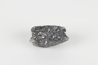
Geological specimen - Galena (lead sulphide), Unknown
Galena occurs in a range of deposit contexts, often in metalliferous veins, such as Broken Hill, Australia; Coeur d’Alene, Idaho, United States.; Clausthal Zellerfeld, Germany; and Cornwall, England. Large deposits also replace limestone, dolomite, or occasionally organic matter, or have a contact-metamorphic origin. Galena is additionally found in cavities, brecciated (fractured) zones in limestone and chert, and in coal beds. This specimen was recovered from Broken Hill NSW and is 60% lead with 8-12 oz/silver to the ton.Galena or 'lead glance' is a grey lead sulfide and the chief ore mineral of lead. It forms isometric crystals in which the ionic lattice is similar to sodium chloride. Galena is brittle and easily weathers to secondary lead minerals, with the upper part of mineral deposits often containing cerussite, anglesite, and pyromorphite. It usually contains silver, which is mined along with its lead content. Other commercially important minerals that form in close association with galena are antimony, copper, and zinc. This specimen is part of a larger collection of geological and mineral specimens collected from around Australia (and some parts of the world) and donated to the Burke Museum between 1868-1880. A large percentage of these specimens were collected in Victoria as part of the Geological Survey of Victoria that begun in 1852 (in response to the Gold Rush) to study and map the geology of Victoria. Collecting geological specimens was an important part of mapping and understanding the scientific makeup of the earth. Many of these specimens were sent to research and collecting organisations across Australia, including the Burke Museum, to educate and encourage further study.A small-sized solid specimen containing one mineral with a sparkly silver metallic lustre exterior and pastel-grey interior.geological specimen, geology, geology collection, burke museum, beechworth, galena, lead sulphide, alfred selwyn, broken hill -
 The Beechworth Burke Museum
Geological specimen - Selwynite, Unknown
Selwynite is a fine-grained, compact green rock made primarily of chromian muscovite (fuchsite) and diaspore. Corundum and fuchsite can occur together in the form of massive aggregates or nodules. Often, copper carbonates are found as earthy films or tiny crystals in joint planes. The mineral name honours the late A. R. C. Selwyn, founding Director of the Geological Survey of Victoria. The particular specimen, a mottled green stone suitable for carving was recovered and found in Heathcote, Victoria, Australia. The rarity and qualities of this mineral attracted commercial mining, which was not successful, but traces of the mine shafts still exist today, and it is still highly valued by mineral collectors.Selwynit is considered to be one of the rare forms of rock because it is composed of phosphate minerals containing zirconium. This is an extremely rare combination found in nature. This specimen is part of a larger collection of geological and mineral specimens collected from around Australia (and some parts of the world) and donated to the Burke Museum between 1868-1880. A large percentage of these specimens were collected in Victoria as part of the Geological Survey of Victoria that begun in 1852 (in response to the Gold Rush) to study and map the geology of Victoria. Collecting geological specimens was an important part of mapping and understanding the scientific makeup of the earth. Many of these specimens were sent to research and collecting organisations across Australia, including the Burke Museum, to educate and encourage further study.A fine grained rock composed of mainly of chromian muscovite (fuchsite) diaspore and corundum.geological specimen, geology, geology collection, burke museum, beechworth, mineralogy, heathcote, mineral collectors, selwynite, green rock, rock specimen -
 The Beechworth Burke Museum
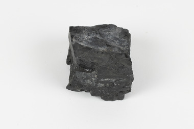
Geological specimen - Bituminous Coal, Unknown
Bituminous coal is the most common type of coal, abundantly found in ancient coal deposits which can be dated back millions of years. Often referred to as soft or black coal, this specimen exhibits a high carbon content, ranging from 76-86%. It also holds a relatively high energy density (27 MJ/kg) meaning that it releases significant amounts of energy when burned. Bituminous coal is most commonly used for electricity generation, as well as in the production of steel. This particular piece of coal was collected as part of the Geological Survey of Victoria in the nineteenth century. It originates from Cape Paterson, a seaside village located in South Gippsland, Victoria (located on Bunurong Country). The discovery of bituminous coal in this locality was first made in 1826 by explorer William Hovell. More discoveries were gradually made over the following decades and in 1859 the Victorian Coal Company commenced the first active coal mining operations in the state by sinking a number of shafts and bores near the area of Cape Paterson. Evidence of this coal-focused past can be found today at the State Coal Mine Museum in the nearby town of Wonthaggi. This specimen is significant as it was collected from the locality of Cape Paterson in Victoria, an area that has since become historically instrumental in the mining of coal and other substances in the state of Victoria. This specimen is part of a larger collection of geological and mineral specimens collected from around Australia (and some parts of the world) and donated to the Burke Museum between 1868-1880. A large percentage of these specimens were collected in Victoria as part of the Geological Survey of Victoria that begun in 1852 (in response to the Gold Rush) to study and map the geology of Victoria. Collecting geological specimens was an important part of mapping and understanding the scientific makeup of the earth. Many of these specimens were sent to research and collecting organisations across Australia, including the Burke Museum, to educate and encourage further study. A solid hand-sized piece of bituminous coal with a shiny black-grey surface and jagged edges.Existing Label: BITUMINOUS COAL / Locality: Cape / Patterson, VIC. burke museum, beechworth, geological, geological specimen, state coal mine museum, wonthaggi coal mine, victorian coal company, bituminous coal, coal victoria, coal energy generation, william hovell, cape paterson, coal specimen -
 The Beechworth Burke Museum
Geological specimen - Malachite, Unknown
... Burra Burra Burra Mine Burra South Australia carbonate mineral ...Malachite is a copper carbonate hydroxide mineral. It has a chemical composition of Cu2(CO3)(OH)2. It often forms within limestone where a subsurface chemical environment favourable for the formation of carbonate minerals can occur. It is a substance that can be found in many different parts of the world including: Australia, USA, Russia and the Democratic Republic of Congo. Malachite has historically been used to produce copper, with mining of the mineral dating back over a period of four thousand years. Due to its beautiful green colourations, it is also commonly used for aesthetic purposes such as in the production of sculptures and jewellery. This particular specimen was collected from the town of Burra, South Australia as part of a geological survey undertaken during the nineteenth century. The locality (located on Ngadjuri Country) has a long history of mining, particularly in copper mining, as the area is rich in copper deposits. The first significant discovery of this was made in Burra (Burra Burra Mine) in 1845 and, at the time, the mine was the largest and richest of its kind in the world, producing nearly five percent of the total world copper output. This specimen is significant as it is considered to be a rare gemstone, as many of the original deposits for the stones are significantly depleted, leaving behind very few sources. This specimen is part of a larger collection of geological and mineral specimens collected from around Australia (and some parts of the world) and donated to the Burke Museum between 1868-1880. A large percentage of these specimens were collected in Victoria as part of the Geological Survey of Victoria that begun in 1852 (in response to the Gold Rush) to study and map the geology of Victoria. Collecting geological specimens was an important part of mapping and understanding the scientific makeup of the earth. Many of these specimens were sent to research and collecting organisations across Australia, including the Burke Museum, to educate and encourage further study.A solid palm-sized copper carbonate hydroxide mineral with patterns of green colourations Existing Label: MALACHITE / Locality: Burra / S. Aust. Other Label: Confirmed / as Malachite / C. Willman / 15/4/1 / + Bill Birch burke museum, beechworth, geological, geological specimen, malachite, gemstone, green gemstone, burra, burra burra mine, burra south australia, carbonate mineral, copper, copper mining, copper mining burra, carbonate hydroxide mineral, copper carbonate, malachite mining, malachite burra, monster mine -
 The Beechworth Burke Museum
Geological specimen - Cassiterite
This specimen is Cassiterite in Quartz. Cassiterite is a tin oxide metal that forms in thin crystals which can have a beautiful lustre. Quartz is made of silicon dioxide, also known as silica, and is one of the most common minerals on earth. Cassiterite has been a fundamental source of tin ore for humans throughout history, including today. Tin is an important metal that has a wide variety of human uses in different areas, from dying fabric, to making mirrors, and their most well-known use ‘tin’ cans. Tin cans are primarily made of steel and are coated with tin in order to take advantage of tin’s property of being non-corroding. This is a massive step in the history of food preservation. Tinned food first reached Australia in 1815 with early settlers, and it began to be manufactured here in the 1840s. It was incredibly popular, and was a highly exported product, which would be a contributing factor to the ‘tin mining boom’ of the early 1880s. This specimen was collected at Jingellic, New South Wales, in about 1852. Although the Goldfields of the 1800s are much more well-known, tin mines existed alongside the gold mines which began in the mid 19th century and extended almost one hundred years, to the mid 20th century. Specimens like this would have been used as evidence to justify tin mining operations in the region as an investment. This specimen is part of a larger collection of geological and mineral specimens collected from around Australia (and some parts of the world) and donated to the Burke Museum between 1868-1880. A large percentage of these specimens were collected in Victoria as part of the Geological Survey of Victoria that begun in 1852 (in response to the Gold Rush) to study and map the geology of Victoria. Collecting geological specimens was an important part of mapping and understanding the scientific makeup of the earth. Many of these specimens were sent to research and collecting organisations across Australia, including the Burke Museum, to educate and encourage further study. The Geological Survey of Victoria was headed by British geologist, Alfred Richard Cecil Selwyn (1824-1902), who was responsible for issuing over 60 geological maps during his 17 years as director. These maps were all hand-drawn and coloured and became the benchmark for accuracy for geological mapping. Collecting geological specimens was an important part of mapping and understanding the scientific makeup of the earth. Many of these specimens were sent to research and collecting organisations across Australia, including the Burke Museum, to educate and encourage further study. A fist-sized solid geological specimen made on one half of tin oxide, which is dark grey, and on the other side of silica, which is brown and cream.burke museum, beechworth, geological, geological specimen -
 The Beechworth Burke Museum
Geological specimen - Native (metallic) copper, Unknown
This specimen is a native copper specimen that is metallic. Copper is typically found in the earth's crust and is often found alongside other metals such as gold, zinc, lead and silver which all belong to the same group which is the Copper/Gold group. Copper is most commonly formed from large masses of molten lava rock which has solidified in the earth's crust and over time though different sizes and speeds of crystal growth has turned into large amounts of copper, stored in porphyry copper deposits. Copper has a distinctive colour, yet can sometime appear blue and greenish which is often caused by oxidisation or a mixture of copper and other metals. This specific specimen was recovered from Moonta, South Australia. The Moonta Mining Company was established in 1861, after a Shepard in the area noticed traces of copper. This lead to a rush in the copper mining industry which was relatively young in Australia at the time, making Moonta Mining Company one of the richest in Australia. By the 1860's, South Australia had been nicknamed the "Copper Kingdom" due to its vast amount of Large copper mines and resources. As of 2016, Australia was the second largest producer of Copper internationally, following behind Chile in first place. This copper specimen is significant historically and scientifically as it is such an important metal commonly used throughout the world in various ways. Copper is an invaluable recourse used in daily life, used in most electrical appliances as it is a great conductor of heat and electricity, as well as being soft and malleable, making it easy to bend and mould into delicate sheets and wires. Copper does not corrode and is therefore used in the production of water pipes among countless other significant necessities that are often overlooked in our society. Historically, Copper holds great significance as it was the first metal used by humans. It was discovered roughly 9000 years ago and was utilised by the Neolithic Man who learnt that heating the metal made it more malleable, thus tools and utensils were made which were far superior to the previous stone tools used by humans. This history and its connection to the current and ongoing relationship between humans and copper must be preserved and highlighted as it is integral to the history of all humankind. A small, palm-sized solid native copper mineral specimen with shades of browns, black and rustic tones throughout the specimen.NATIVE (metalic) COPPER / Locality: Moonta, South Australiabeechworth, burke museum, geological specimen, native specimen, geological, mineral, mineralogy, indigo shire, beechworth museum, copper, copper ore -
 The Beechworth Burke Museum
Geological specimen - Cerussite, Unknown c.1890s
... potential give it significance; mined in an Australian township ...Named in 1845 by Wilhelm Karl von Haidinger cerussite takes its name from the Latin cerussa, meaning 'white lead'. When viewed under certain lighting conditions cerussite gives of fire and rainbow-like colours (due to its high dispersion) and it is quite sought after by geological collectors for this very reason. Cerussite is usually found in the oxidised zone of lead ore deposits. It is a very common weathering product of galena and other lead ore minerals. It is a secondary mineral, meaning it forms as a result of the alteration of pre-existing minerals in the Earth’s crust. The presence of lead in cerussite makes it potentially toxic. Historically, it has been an important source of lead, which has numerous industrial applications, including in batteries, construction materials, and radiation shielding. Cerussite has a crystal structure that belongs to the orthorhombic crystal system. Its crystal structure is characterized by a three-dimensional arrangement of atoms in a repeating pattern. The crystal lattice of cerussite consists of interconnected lead (Pb) and carbonate (CO3) ions. This crystal structure is visible in the specimen. This specimen was found in Dundas (formerly Mount Dundas), a historical mining locality, mineral field and railway located on the western foothills of the West Coast Range in Western Tasmania. During the 1890s Dundas swelled in numbers however it is now lost in a temperate rainforest and its population is now 2. The present Dundas Extended mine, about 1.5 km east of Dundas is presently worked for specimen material.Faceted cerussite gems are considered rare and valuable, given the softness of the mineral. This item is not a faceted gem however its historical and scientific research potential give it significance; mined in an Australian township, this cerussite could shed light on the now lost history of Dundas and the mining that occurred there. Additionally, the uses of this mineral in historical industrial processes give it scientific significance. Such knowledge can add to understandings of the geographical and geological nature of Western Tasmania and allow for further study of Australian geological specimens. A small lead carbonite mineral with shades of cream, white and brown throughout, flaky shards of white at base. CERUSSITE / (lead carbonite) / Locality: Dundas, W. Tasmaniadundas, tasmania, cerussite, lead, orthorhombic, geology, minerals, mining -
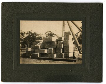
 Orbost & District Historical Society
black and white photograph, early 1900s
In the early 1900s black marble was being mined in the Bruthen district. Some was used for the Shrine of Remembrance in Melbourne and Australia House in London. 900 tonnes were shipped to London to be included in the construction of Australia House. This photograph shows the last 120 ton slab to be used to complete the sixteen dark Buchan marble Ionic columns in the Shrine of Remembrance in Melbourne. The Shrine of Remembrance was created to meet the needs of a grieving community after the extensive loss of lives in the First World War (1914 –18). Marble quarrying has been a significant part of the history of Buchan in East Gippsland. Its inclusion in the Shrine of Remembrance War Memorial is noteworthy.A black / white photograph mounted on a soiled grey buff card. It shows a man standing in front of a large vertical slab of marble.on front - " 120 tons in this piece. The final 6 columns for the Shrine of Remembrance were cut from it."buchan-marble shrine-of-remembrance-melbourne south-buchan-quarries -
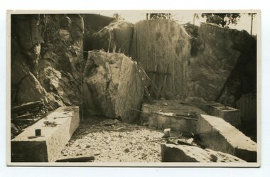
 Orbost & District Historical Society
black and white photograph, first half 20th century
This photograph shows men cutting marble slabs at Buchan on James Cameron's property. The marble was used in the Shrine of REmembrance in Melbourne. The slabs in the photograph were about 8.5 metres long. The Shrine of Remembrance was created to meet the needs of a grieving community after the extensive loss of lives in the First World War (1914 –18). Sixteen dark Ionic columns were made of .Buchan marble In the early 1900s black marble was being mined in the Bruthen district. Some was used for the Shrine of Remembrance in Melbourne and also Australia House in London. 900 tonnes were shipped to London to be included in the construction of Australia House. Marble quarrying has been a significant part of the history of Buchan in East Gippsland. Its inclusion in the Shrine of Remembrance War Memorial is noteworthy.A black / white photograph of four men working in a quarry with three large slabs of marble on the ground.on back - " Cutting marble slabs......"buchan-marble shrine-of-remembrance cameron-james geology -
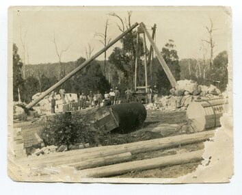
 Orbost & District Historical Society
black and white photograph, first half 20th century
In the early 1900s black marble was being mined in the Bruthen district. Some was used for the Shrine of Remembrance in Melbourne and Australia House in London. 900 tonnes were shipped to London to be included in the construction of Australia House.Marble quarrying has been a significant part of the history of Buchan in East Gippsland. Its inclusion in the Shrine of Remembrance War Memorial is noteworthy.A black / white photograph of a quarry pit with marble slabs on the ground.on back - "Marble blocks for the Shrine of Remembrance..."buchan-marble shrine-of-remembrance australia-house -
 Orbost & District Historical Society
black and white photograph, first half 20th century
This photograph shows marble waiting to be loaded on the train at Nowa Nowa Station to be sent to Melbourne for the Shrine of Remembrance and Australia Housee in London. In the early 1900s black marble was being mined in the Bruthen district. Some was used for the Shrine of Remembrance in Melbourne and Australia House in London. 900 tonnes were shipped to London to be included in the construction of Australia House.Marble quarrying has been a significant part of the history of Buchan in East Gippsland. Its inclusion in the Shrine of Remembrance War Memorial is noteworthy.A black / white photograph mounted on a dark grey buff card. It shows a man and a dog sitting next to slabs of stacked marble.on back - " Marble stacked at Nowa Nowa Rail Station for Australia House."buchan-marble australia-house shrine-of-remembrance nowa-nowa-railway geology -
 Orbost & District Historical Society
black and white photograph, first half 20th century
This photograph shows men working on cutting marble at South Buchan for Australia House in London. In the early 1900s black marble was being mined in the Bruthen district. Some was used for the Shrine of Remembrance in Melbourne and Australia House in London. 900 tonnes were shipped to London to be included in the construction of Australia House. DESCRIPTIONA paper covered booklet which is a pictorial souvenir Of Australia House in London. Pictures show Buchan marble features of the building.SIZE H-266mm W-192mm OBJECT REGISTRATION654KEYWORDSbuchan-marble australia-houseHISTORICAL INFORMATIONAustralia House is the oldest Australian diplomatic mission and it is the longest continuously occupied foreign mission in London. King George V laid the building’s first foundation stone in 1913 but it was not until August 1918 that he officially opened the completed building. The stringencies of World War I – principally shipping difficulties and labour shortages – had delayed construction considerably. Federation of the six Australian states formally took place on 1 January 1901 but it was not until 1906 that the Federal Government sent an Official Secretary to London to represent Australia. In the intervening years Australia was represented by State Agents-General, the first of whom was the Agent-General of Victoria. The building is significant for its unique design, Beaux Arts style and the materials used in its construction.Marble quarrying has been a significant part of the history of Buchan in East Gippsland. Its inclusion in Australia House in London and the shrine of Remembrance in Melbourne is noteworthy.A small black / white photograph of men in the background of a marble quarry. There is also a copy.on back - " Cutting Australian Home Marble at Sth Buchan"buchan-marble geology australia-house -
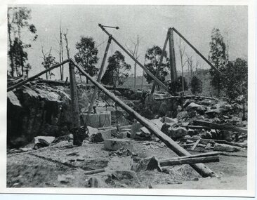 Orbost & District Historical Society
black and white photograph, first half 20th century
In the early 1900s black marble was being mined in the Bruthen district. Some was used for the Shrine of Remembrance in Melbourne and Australia House in London. 900 tonnes were shipped to London to be included in the construction of Australia House.Marble quarrying has been a significant part of the history of Buchan in East Gippsland. Its inclusion in the Shrine of Remembrance War Memorial and Australia House in London is noteworthy.A large black / white photograph of men working in a marble quarry.buchan-marble geology shrine-of-remembrance australia-house-london -
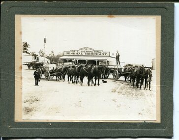 Orbost & District Historical Society
black and white photograph, early 20th century
This photograph shows Buchan marble being transported by horse and wagon to Nowa Nowa Railway Station. Lnidsay Cameron is the driver on the right. In the background is the Commercial Store of T. L. Sherrington, General Merchant, Bruthen. In the early 1900s black marble was being mined in the Bruthen district. Some was used for the Shrine of Remembrance in Melbourne and Australia House in London. 900 tonnes were shipped to London to be included in the construction of Australia House. Marble quarrying has been a significant part of the history of Buchan in East Gippsland. Its inclusion in the Shrine of Remembrance War Memorial and Australia House in London is noteworthy.A black / white photograph on a grey buff card. it is of four horse drawn wagons in front of a general store - "T L Sherrington General Merchant". There are five men standing on the trays and a man in a suit and hat holding a Gladstone bag is standing front left. a dog is lying on the ground between the wagons. The wagons are carrying large slabs of marble.on back - " Marble passing through Bruthen on way to railway"buchan-marble geology cameron-lindsay transport-rail transport-horse-drawn -
 Orbost & District Historical Society
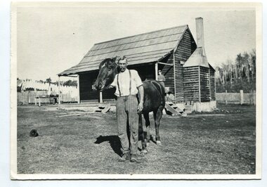
black and white photograph, late 19th century - early 20th century
There are records of members of the Helmers family attending Bendoc State School. George Helmers was a prospector who mined all the gold from the dry gullies that ran into Bendoc. George was born in 1866, in Bombala, New South Wales, Australia. He was married to Euphemia Lock, born on October 19 1870, in Bendoc Upper, Victoria, Australia.This photograph is associated with early settlers of Bendoc, East Gippsland.A large black / white photograph of a man standing in front of a wooden cottage. there is a horse beside him, a woman standing on a verandah in the background and on the left is a clothes line with what seem to be nappies pegged out. There is also a copy of the original. on back - "George Helmers, Errinundra"helmers-george-bendoc -
 The Beechworth Burke Museum
Photograph, Unknown
The A1 Gold Mine is located north of Woods Point, near Jamieson, in the Upper Goulburn region of Victoria. Gold was discovered at the A1 site in 1861 and mining operations began in 1864. The A1 Mine Settlement refers to a small township known variously as Castle Reef, Castle Point, and Raspberry Creek, which developed in the 1860s around mining industry centred on a crushing machine that worked the three gold reefs in the area. Historically, the name "A1"referred to the high quality of gold found in the quartz reefs at depths of at least two thousand feet. Along with the Morning Star mine at Woods Point, the A1 gold mine produced almost sixty percent of Victoria's gold output in the 1950s to 1970s and continued operating until 1992 when it went into administration. Operations at the site were revived in 2016 and the A1 Mine is now considered one of Victoria's premier gold mines. The A1 mine is part of the extensive and prospective Lachlan Fold Belt, a north-west trending belt of tightly folded Early Devonian sedimentary rocks extending from New South Wales to Victoria. Mineralisation is hosted within or immediately adjacent to diorite dykes. Contemporary development of the 'Queens Lode' at the A1 mine signals a move from high-grade, narrow vein airleg mining into larger scale, mechanical mining designed to increase ore production volume. This original, undated photograph of the A1 Mine appears to depict an area or phase of disuse or abandonment. The aged and humble appearance of the cottage suggests association with the historical A1 Mine Settlement, therefore the image may have been taken prior to the 1950s-1970s revival period in which the A1 mine is known to have produced high gold yields. The photograph contributes to our understanding of the A1 Gold Mine's impact on the landscape and the social, environmental impacts of mining on communities and may be compared with others in the Burke Museum's extensive collection of mining photographs to deepen our understanding of mining in the Jamieson area.Black and white rectangular photograph printed on photographic paperReverse: 5577 / A1 Mine / Near Jamieson / Vic. /burke museum, beechworth museum, beechworth, gold fields, gold rush, victorian gold rush, mining tunnels, gold ming history, colonial australia, australian gold rushes, mining technology, beechworth historic district, indigo gold trail, indigo shire, upper goulburn shire, jamieson, woods point-walhalla goldfield, a1 gold mine, victorian high country, modern mining methods, orogenic gold province, gold mineralisation, devonian, dykes