Showing 17183 items matching "bay-bridge"
-
 Marysville & District Historical Society
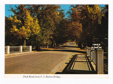
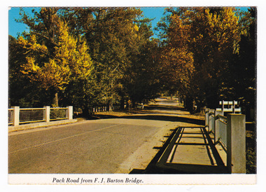
Postcard (item) - Colour postcard, Nucolorvue Productions Pty. Ltd, Pack Road from F.J. Barton Bridge, Pre 2009
A colour photograph of Murchison Street from the F.J. Barton Bridge in Marysville in Victoria.A colour photograph of Pack Road from the F.J. Barton Bridge in Marysville in Victoria. Labeling is incorrect. The view is looking down Murchison Street from the F.J. Barton Bridge. The F.J. Barton Bridge was named after Frederick John Barton. The Barton Family were amongst Marysville's first pioneering families. This postcard was published by Nucolorvue Productions as a souvenir of Marysville.NU-COLOR-VUE/ OF / AUSTRALIA MARYSVILLE, VICTORIA. Pack Road from F.J. BARTON/ BRIDGE. PLACE/ STAMP/ HERE POST CARD NCV.172 - NUCOLORVUE PRODUCTIONS PTY. LTD./ COPYRIGHT Printed in Australiamarysville, f.j. barton bridge, murchison street, victoria, postcard, souvenir, nucolorvue productions, fj barton -
 Kew Historical Society Inc
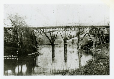
Print, Studley Pk Toll Bridge, July 12 1899
Black and white print photograph of the wooden 'Penny Bridge' at Studley Park. The name was colloquially arrived at as a penny wa the toll one paid to cross the bridge. The copy of the postcard identifies the photographers as McAlpin Bros, Richmond.Reverse: "Studley Pk Toll Bridge / joining Church Street Abbotsford / Penny Bridge"toll bridges -- river yarra, bridges - yarra river -- kew (vic.), penny bridge -
 Lakes Entrance Historical Society
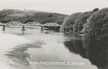
Postcard - Tambo River bridge at Bruthen Victoria, H D Bulmer
Ringbarked trees on hill in background and willows along river bankBlack and white postcard of bridge over the Tambo River at Bruthen Victoria'TAMBO RIVER BRIDGE AT BRUTHEN'agriculture, rivers, bridge -
 Eltham District Historical Society Inc
Photograph, Fay Bridge, Eltham Railway Trestle Bridge, n.d
fay bridge collection, eltham, eltham railway trestle bridge, trestle bridge -
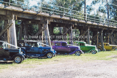 Eltham District Historical Society Inc
Photograph, Fay Bridge, Hot Rods at the Eltham Railway Trestle Bridge, n.d
fay bridge collection, eltham, eltham railway trestle bridge, trestle bridge, eltham trestle bridge, hot rods -
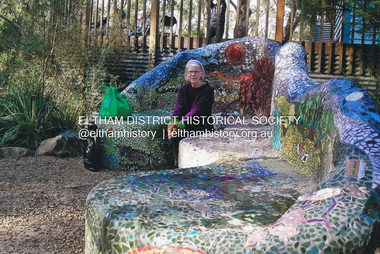 Eltham District Historical Society Inc
Photograph, Fay Bridge, Fay Bridge with the Lasting Memories Mosaic Seat, St. Andrews Hall, 1 Proctor Street, St. Andrews, n.d
The Lasting Memories Mosaic Group Seat is part of Nillumbik Shire Council's Public Art. Following the Black Saturday Bushfire of February 7, 2009, which ravaged St Andrews and surrounding district, a group of bushfire affected women formed the Lasting Memories Mosaic group and created this concrete seat covered in mosaic as part of their healing process. It was completed in 2012. For more information see Nillumbik Shire Council's link Public Art: Lasting Memories Mosaic GROUP, Lasting Memories Mosaic Seat - https://victoriancollections.net.au/items/58536395d0ce201b746561c6fay bridge collection, fay bridge, mosaics, st andrews, lasting memories mosaic group seat, st andrews hall -
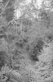
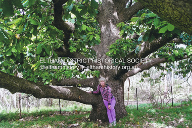 Eltham District Historical Society Inc
Photograph, Fay Bridge, Fay Bridge with New Zealand Oak at former Morrison property, Killeavey, Laughing Waters Road, Eltham, n.d
Beatrice Wanliss Irvine was the daughter of former Victorian Premier Sir William Irvine. From age 13 she lived at “Killeavey” off Laughing Waters Road (later accessed from Reynolds Road). In 1923 she married James Morrison and the couple received Killeavey as a wedding gift. The property supported fruit and vegetable growing as well as an impressive botanical garden. But James died in 1936 after a period of ill health, leaving Beatrice to support their six children. The Killeavey house was built atop a cliff, 40 metres above the Yarra River. The garden was designed in 1910 by William Guilfoyle who was the second director of the Royal Botanical Gardens. The house was totally destroyed in the Black Friday bushfires in 1939, but was rebuilt. Beatrice continued to live at Killeavey and became well regarded as a botanist and naturalist. She died in 1989 and is buried in Eltham Cemetery with her husband and one of their sons. The (rebuilt) house was demolished by Parks Victoria. It contains significant garden remnants. The surrounding bushland is valued for its significant plant communities.fay bridge collection, beatrice wanliss morrison (nee irvine), eltham, james morrison, killeavey, laughing waters road, william irvine, new zealand oak, fay bridge -
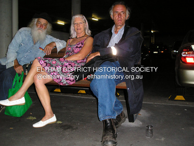 Eltham District Historical Society Inc
Photograph, Fay Bridge, Maurice Hurry, Fay Bridge and Damian Skipper, 2016
fay bridge collection, damian skipper, eltham town square, fay bridge, maurice hurry, safeway supermarket, 2016 -
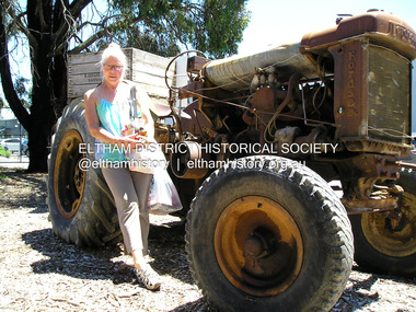 Eltham District Historical Society Inc
Photograph, Fay Bridge, Fay Bridge with Fordson Tractor at H.Aumann & Sons. Fruit &/or Berry Growers. 246 Tindals Rd, Warrandyte, 29 January 2018
fay bridge collection, 2018-01-29, fay bridge, fordson tractor, h. aumann & sons, warrandyte -
 Port Melbourne Historical & Preservation Society
Document, Jan HARPER, Sugar and Starch to Sandridge Bay Towers, 2023
Jan HARPER's document covers the history of the building from the Victorian Sugar Works to Harper's Starch Factory to Sandridge Bay Towers.White oblong 26 page publication with colour photograph of Sandridge Bay Towers on the cover.sandridge bay towers, harpers starch factory, victorian sugar works -
 Ringwood and District Historical Society
Photograph, Mullum Creek from bridge in Warrandyte Rd. Looking East 1970
From bridge in Warrandyte Road. See DB Item 2957 for later photo, same scene, with bridge identified.Typed below photograph, "Mullum Creek 1970 from bridge" -
 Kew Historical Society Inc
Photograph, Outer Circle Railway Viaduct, 1919
Railway Viaduct constructed for the Outer Circle Railway. Bridge designed by John Monash, engineer. Converted into a state highway, 1930s.Dateable photo of an important piece of Victorian railway infrastructure.Photograph of Outer Circle Railway Bridge over River Yarra, Fairfield. Looking toward Lugton Street, showing fence underneath taken from the Chandler Highway. Reverse: "Outer Circle Railway Bridge over River Yarra Fairfield, H0276, Property of Miss Foley"railway viaduct, chandler highway -
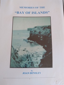 Peterborough History Group
Book, Memories of the Bay of Islands + Crofts Bay Huts
Early use of Crown Land for holiday makers prior to the Great Ocean Road extension, when leaseholders were forced to relinquish their land and houses. Includes a list of the names of occupants at that time. Also includes letters from the Crown Lands Dept about the efforts to retain the Crofts Bay Huts.Significant because it is an eyewitness description of the huts which were demolished in the mid 1970's. Also describes holiday activities and mentions other families in the area.Folder containing the photocopy of the book by Joan Densley and the separate story of the Crofts Bay huts.including copies of Crown Land documents and letters. Includes copy of photographs of the huts and beach.peterborough, crofts bay, bay of islands, joan densley, great ocean road, crofts bay huts, bay of islands huts -
 Otway Districts Historical Society
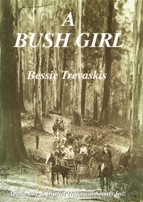
Book, Apollo Bay & District Historical Society Inc, A Bush Girl, December 2001
A family history about the Holmes family and one daughter's marriage to Mark Trevaskis between 1897 and 1912.A Bush Girl. A story about life in the Otway ranges between 1897 and 1912. Eveline Bessie Orlina Trevaskis. Apollo Bay; Apollo Bay & District Historical Society; 2001. vi, 64 p.; illus, maps. Soft cover. ISBN 0 9577956 2 9a bush girl; bessie trevaskis; otway ranges; family history; barramunga; wongarra; -
 Lakes Entrance Historical Society
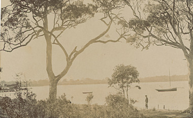
Postcard, Bancroft Bay Metung Victoria, 1900 c
Two small boats moored in bay person standing on shoreSepia toned postcard taken from waterfront looking across Bancroft Bay towards Boole Poole Metung Victoria boats and boating, jetties, waterways -
 Flagstaff Hill Maritime Museum and Village
Photograph - Historical, Flagstaff Hill, John Lindsay, View of the Bay from the south boundary of the Ports and Harbours land, 1970s
The photograph shows the view of the shore and Lady Bay with the Breakwater and Middle Island all visible. It was taken to show that the Flagstaff Hill area was unlikely to have any further development between it and the Bay, with the view of development of the Flagstaff Hill Maritime Museum and Village. This photograph, a print, is one of a set of five that show the site of Flagstaff Hill. The photographer was John Lindsay, Founding Director of Flagstaff Hill Maritime Museum and Village, with the words "Photo J Lindsay" on the back. It was taken in the early 1970s during the initial stages of the development of Flagstaff Hill as a Museum and Maritime Village. The photographs belonged to the donor's grandparents, who lived in the Warrnambool district of Allansford/Naringal. The photograph is a record of the site and surrounds of Flagstaff Hill Maritime Museum and Village before its development and opening in 1975. It shows the Surfside Holiday Park, Surf Lifesaving Club, and the Breakwater. The photograph is significant for recording the location and condition of the Lower Lighthouse on the Hill.Coloured photograph, glassy print, one of a set of five. Flagstaff Hill's Lower Lighthouse is in the foreground above the Surfside Holiday Park. To the right of centre is the Surf Lifesaving Club. In the background is Lady Bay and the Breakwater and Middle Island, with the Southern Ocean the other side. The photograph's paper has the printer's watermark and a pencilled inscription on the back. The early 1970s scene was photographed by John Lindsay, Warrnambool.Label on the back: "VIEW OF THE BAY FROM the southern boundary of the Ports and Harbours land. No development below this area is likely to obstruct the view, due to the steep grade down to the Southern boundary of Flagstaff Hill property." Handwritten in pencil: "Photo J Lindsay"flagstaff hill, flagstaff hill maritime museum and village, warrnambool, maritime museum, maritime village, great ocean road, shipwreck coast, 1970s, photograph, surfside holiday park, lady bay, flagstaff hill site, john lindsay, lower lighthouse, lower light, surf lifesaving club, breakwater, middle island, ports and harbours -
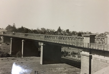
 Kew Historical Society Inc
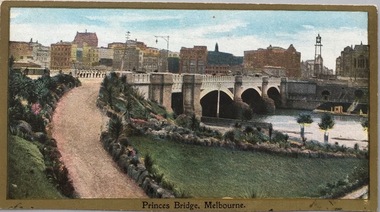
Postcard, Princess Bridge, Melbourne, c.1907
The Kew Historical Society's postcard collection includes views of Kew, Melbourne and Greater Melbourne as well as those including overseas scenes sent or received from Europe or the Middle East. They date from the 1890s to the 2000s. These postcards may or may not include the name of the publisher or printer. A number of the cards were published as parts of popular series. A way of dating early postcards is to identify whether the reverse was divided by a central line which became the norm after 1902 in the United Kingdom. However, other postcards produced after this date do not always conform to this print layout.Rare variant version of this view of Princes Bridge, from the south-east bank of the Yarra River, looking towards the city of Melbourne, showing landmarks of the period.Polychrome postcard of Princess Bridge in Melbourne.Princess Bridge, Melbourne Miss McGilivray, "Oak Bank", Peterborough, _____. princess bridge -- melbourne (vic.), river yarra, postcards -- melbourne (vic.) -
Stawell Historical Society Inc
Painting, Will Rees, Water colour of property at Dadswells Bridge
Property painted was Bill & Jean (Cumming) Howards. They were beekeepers & farmers at Dadswells Bridge. Jeans father was a friend of Will Rees. Audrey's (donor) husband Bob Cummings was raised by the Howards from age of 9.Watercolour Painting by Will Rees Stawell artist. Landscape trees two buildings & sheep. Property at Dadswells Brudge. In brown Frame, reflective glassSigned by Will Reespainting, artwork -
 Kew Historical Society Inc
Postcard, Walhalla Train Crossing Thomson Bridge, c.1910
One of a number of 'real photo' and commercial postcards created by or owned by members of the Christian and Washfold families of Kew. The postcards are part of a larger collection of photographs, postcards and publications donated to the collection in May 2021.Small black and white 'real postcard' of the Walhalla Train crossing the Thomson Bridge.Walhalla Train Crossing Thomson Bridgehenry christian (1886-1962), landscape photography, thomson river (vic.), thomson bridge (vic.), trains -- walhalla -- victoria, christian-washfold collection -
 Marysville & District Historical Society
Postcard (item) - Colour postcard, Nucolorvue Productions Pty. Ltd, Pack Road from F.J. Barton Bridge, Pre 2009
A colour photograph of Murchison Street from the F.J. Barton Bridge in Marysville in Victoria.A colour photograph of Pack Road from the F.J. Barton Bridge in Marysville in Victoria. Labeling is incorrect. The view is looking down Murchison Street from the F.J. Barton Bridge. The F.J. Barton Bridge was named after Frederick John Barton. The Barton Family were amongst Marysville's first pioneering families. This postcard was published by Nucolorvue Productions as a souvenir of Marysville.NU-COLOR-VUE/ OF / AUSTRALIA MARYSVILLE, VICTORIA. Pack Road from F.J. BARTON/ BRIDGE. PLACE/ STAMP/ HERE POST CARD NCV.172 - NUCOLORVUE PRODUCTIONS PTY. LTD./ COPYRIGHT Printed in Australia (Note our new/ bridge) Hullo Dot,/ Very pleased to/ have the chance to meet someone who/ can tell us your news. All the best from/ all the family here at Marysville/ Terry. Dear Dot,/ Good to hear/ first hand news/ of you. Regards,/ Elsie Walkermarysville, f.j. barton bridge, murchison street, victoria, postcard, souvenir, nucolorvue productions, fj barton -
 Port Fairy Historical Society Museum and Archives
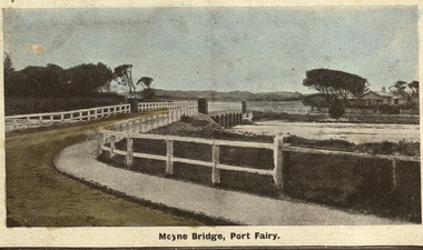
Photograph - Postcard, Moyne bridge
Photograph hand tinted of the Moyne river road bridge taken from Gipps Street showing house on the far bank on the right side taken for use as a PostcardMoyne Bridgemoyne bridge 1910, moyne river, traffic, gipps street -
 Mt Dandenong & District Historical Society Inc.
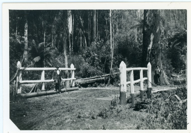
Photograph, Barber's Bridge on Olinda Creek
John Lundy-Clarke grew up in the Kalorama/Mt Dandenong area and later in life (1972-74) began to write a comprehensive history of the area working from an original settlement map in an effort to cover all areas. Barbers Bridge was named after George Barber, an early settler.Black and white photograph showing a man standing on a bridge over the Olinda Creek. 1910Handwritten n reverse: Barbers Bridge on Olinda Creek 1910. This was a ford crossed by the road after Isaac Jeeves selected allotment “C” “Jeeves Saddle” in 1871 and stopped travel through his property. The bridge has been built several times but at time of writing (1974) is replaced by a culvert consisting of two pipes two feet six inches wide. They are quite incapable of carrying the maximum flow of the creek and will be swept away.lundy-clarke, barber, barbers bridge, isaac jeeves, jeeves saddle, bridge, olinda creek -
 Ringwood RSL Sub-Branch
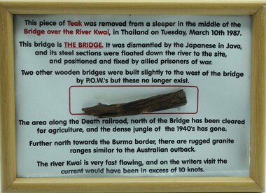
Souvenir Framed item, Piece of bridge from the Burma Railway, C 1987
Wooden frame with text and a piece of teak from the Bridge over the River Kwai.Collected from the bridge on 10th March 1987. -
 Marysville & District Historical Society
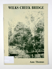
Book, Wilks Creek Bridge, 1993
A history of the Wilks Creek Bridge and its connection to the Yarra TrackPaperback. Front cover has an old photograph of the Wilks Creek Bridge.Dear Reader, The pen has only to select one of the many stages of building old Yarra Track,/ for a colorful story subject. The Track, first established in the early 1860's to/ serve goldseekers making their hazardous way to the rich Wood's Point goldfields,/ extended some 160km from Eltham - in Melbourne's northern region to Woods/ Point in the eastern ranges. I hope a glimmer of the excitement of those times comes through as I draw/ your attention to old Wilks Creek bridge and its picnic spot to be found 3.5km/ west of Marysville. Once part of Yarra Track and now superseded by a modern/ roadway alongside, the old bridge with its solid masonry walls either side of the/ cold, pure stream makes a pleasing scene for the visitor. With much pleasure/ I dedicate this narrative to Marysville and District Historical Society./ Ann Thomas Stamp of Marysville & District / Historical Society Inc / P.O. Box 22 / Marysville 3779wilks creek, marysville, yarra track, victoria, history, local history -
 Victorian Interpretive Projects Inc.
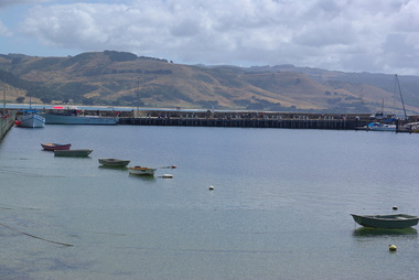
Photograph - Colour, Clare Gervasoni, Apollo Bay Marina, 2013, 27/01/2013
The image show the number and typs of boats moored at Apollo Bay Marina in late January 2013.Two colour photgraphs showing the marina at Apollo Bay from the pier. .1) a number of anchored boats .2) a number of fishing vessells at the marina. apollo bay, boat, vessel, fishing -
 Stawell Historical Society Inc
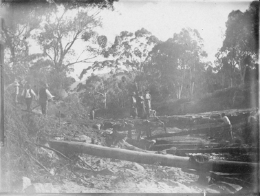
Photograph, Bridge Building -- Possibly Delley's Bridge c1901
Photo of 3 women with a dog standing on a bridge with 5 men possible working on the Bridge in the Grampians. Photo taken in the area where Delley’s Bridge now stands, Hall’s Gap. c1901Sepia Post Card depiction people around a log bridge over a waterway in bush setting.Post Cardstawell -
 Melton City Libraries
Photograph, Edna and Bon's family camp trip at Apollo Bay, 1948
Wendy Barrie's memories of Apollo Bay The camping trips were a yearly event after the harvest had finished. The trip down to the beach was a much-anticipated event heading out through Parwan and to Geelong leaving behind the hot and dusty plains and our parents relieved to have the hard work of harvesting left behind. The Otways in the distance were reached with great anticipation, Mum in the car and Dad in the Truck ahead of us anxiously winding through the narrow roads and negotiating the hairpin bends and breathing in the cool fresh air of the forest, and keeping an eye out of the log trucks that might come sweeping the corner. The tree ferns with their dripping moisture and the giant trees and the unmistakeable small of the eucalypts. Great excitement was when we caught our first view of the sea from the highest point of the road and then is was the cautious drive the sea level to the sight of the blue ocean with the white of the waves crashing on the rocks and the pristine sand. The water from the Wild Dog and Skenes creek trickling onto the ocean. The tree ferns with their dripping moisture and the giant trees and the unmistakeable smell of the eucalypts. The return journey was usually taken on the Great Ocean Road, it was considered safer to be on the inside of the road. In the early days it was very narrow and passing oncoming cars was taken very cautiously. Landslides and floods sometimes meant we would take the inland route. One year the bridges were washed away and bailey bridges were erected to keep the road open. Rock falls off the cliffs were common Stops on the way home gave us our last chance for our feet in the sand and a swim in the ocean. By the time we reached the hill at Angle Sea the vast blue ocean was behind us and we trekked back through Geelong- Bacchus road and the plains of stubble and the dry grass, and sometimes evidence of burnt patches from a bush fire. The closest we came to a pool at home was the concrete sheep trough at the gate to the work sheds. It was filled with bore water pumped from the nearby windmill. Edna, Bon and their family members at their camp site in Apollo Baylocal identities -
![Mount St. George, Addis Bay / [by] Nicholas Caire, circa 1876](/media/collectors/550653872162f11fb04854aa/items/57833f9fd0cdd1176c6828f5/item-media/57833ffdd0cdd1176c685980/item-fit-380x285.jpg) Kew Historical Society Inc
Kew Historical Society IncPhotograph, Anglo-Australasian Photographic Company, Mount St. George, Addis Bay, c. 1876
Nicholas Caire was born on Guernsey in the Channel Islands in 1837. He arrived in Adelaide with his parents in about 1860. In 1867, following photographic journeys in Gippsland, he opened a studio in Adelaide. From 1870 to 1876 he lived and worked in Talbot in Central Victoria. In 1876 he purchased T. F. Chuck's studios in the Royal Arcade Melbourne. In 1885, following the introduction of dry plate photography, he began a series of landscape series, which were commercially successful. As a photographer, he travelled extensively through Victoria, photographing places few of his contemporaries had previously seen. He died in 1918. Reference: Jack Cato, 'Caire, Nicholas John (1837–1918)', Australian Dictionary of Biography.An original, rare photograph from the series 'Views of Victoria: General Series' by the photographer, Nicholas Caire (1837-1918). The 60 photographs that comprise the series were issued c. 1876 and reinforced a neo-Romantic view of the Australian landscape to which a growing nationalist movement would respond. Nicholas Caire was active as a photographer in Australia from 1858 until his death in 1918. His vision of the Australian bush and pioneer life had a counterpart in the works of Henry Lawson and other nationalist poets, authors and painters.‘Mount St. George, Addis Bay’ : Views of Victoria (General Series) No.56 : Albumen silver photograph | Photo on card with Title and Description on reverse | Mounted 24 x 30 cm; Photo 12 x 17 cm.On Reverse: ‘Addis Bay is situated to the north-east of Appollo Bay, and very near Cape Patten. This mountain is 6,000 feet high, and commands one of the finest views on the Cape Otway Ranges. The ascent is a somewhat difficult one, but visitors to this locality not unfrequently make this a favourite outing.’nicholas caire (1837-1918), landscape photography -
 Flagstaff Hill Maritime Museum and Village
Document - Navigation Chart, Admiralty Office, Lady Bay and Warrnambool Harbour, 03/04/1871
This Chart titled “Lady Bay and Warrnambool Harbour” was surveyed by Nav. Lieut. H.J. Stanley, of Britain's Royal Navy, in 1870 and printed in April 1871. The chart was made before the Warrnambool Breakwater was built (construction had begun in 1874 and was completed in 1890). The chart includes Directions for entering Lady Bay, Warrnambool Harbour. These are "Vessels entering Warrnambool Harbour must bring the Red Light in sight and steer in with it in line with the upper white Light bearing North, until the Green Light on the Jetty is opened, when steer towards it and anchor. The best anchorage is in 2 ¼ fms [fathoms)] of water, about a cable from ledge off Breakwater rock. Or where convenient, according to draught of water, only endeavouring to anchor as close as possible to Breakwater rock. It is not safe to enter or leave the Harbour in south westerly or Southerly gales.” This chart is significant for its strong connection to the maritime history of Warrnambool Harbour and Lady Bay, and eventually to the Warrnambool Breakwater. The Warrnambool Breakwater is registered as a place of significance on the Victorian Heritage Database (VHR H2024). A copy of the same chart was used to plan several submissions for future changes to the jetty and breakwater. The chart is a historical record of structures existing in 1870; the Warrnambool Jetties, Lady Bay, the leading lights (lighthouses), streets, roads, bridges and many buildings. It also shows the lay of the land and seabed.Canvas chart of Australia, South Coast, Victoria Title: Lady Bay and Warrnambool Harbour Surveyed by Nav. Lieut. H.J. Stanley, R.N., 1870. Magnet Variation, 1870 Published April 3, 1871, by the Admiralty, London. Directions for vessels entering Warrnambool Harbour are printed on the chart. The chart has a lacquer or seal over it.Top of chart has logo "HYDROGRAPHER OFFICE" "Price Eighteen Pence". "Engraved by Edward Weller" Along bottom of Chart: “London… Published at the Admiralty, 3rd April 1871, under the Superintendence of Rear Admiral G.H. Richards, F.R.S. Hydrographer, Corrections July 71” Bottom of chart “Australia South Coast Victoria Lady Bay and Warrnambool Harbour. 2494”flagstaff hill, warrnambool, chart of lady bay warrnambool 1870, warrnambool harbour, cartography, navigation, warrnambool breakwater, 1871, australia – south coast / victoria, lady bay, 1870, nav. lieut. h.j. stanley, r.n, directions for entering warrnambool harbour, hydrographer office, rear admiral g.h. richards, edward weller, port of warrnambool, flagstaff hill maritime museum & village, maritime museum, maritime village, shipwreck coast, map, chart, navigation chart, admiralty chart, breakwater, jetty, pier, vhr h2024 -
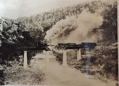
 Ballarat Heritage Services
Photograph - Photograph - Colour, Clare Gervasoni, Nimon's Bridge, 1999, 04/10/1999
Nimons Bridge was built in 1890, as part of the then Ballarat-Linton railway. The bridge is 17 spans with tall timber piers of four driven piles each, with triple sets of diagonal cross-bracing and walers and a single row of longitudinal horizontal bracing between piers. The spans are of a uniform twenty feet (6.1 metres), originally supported by four 21-inch x 9-inch (535 mm x 230 mm) Kauri timber beams per span, following the standard V.R. design of the period. When the superstructure was rebuilt after the 1953 fire, the timber beams were replaced with two 24-inch (610mm) deep rolled-steel-joists on each span. These are marked 'Lancashire Steel Co., Scotland' and are believed to have been second-hand. The deck of transverse-timber planks is 103.6 metres in length. Overall the bridge has an impressive appearance with its exceptionally tall triple-cross-braced piers creating a 'three-tiered' effect, with the deck 19.2 metres above the Woady Yaloak River. The Ballarat-Skipton line closed in 1985. Nimons Bridge has been recently restored, as part of the Ballarat-Skipton Rail Trail. How is it significant? Nimons Bridge is significant for technical, historic and aesthetic reasons at a State level. Why is it significant? Nimons Bridge is technically significant as Victoria's fourth-tallest timber trestle bridge when built, and as the third-tallest surviving example. It is also the second-largest composite bridge combining traditional timber piers with RSJ spans and a timber deck and falls within a select group of fewer than ten timber railway bridges with horizontal longitudinal bracing between the piers and three sets of double cross-bracing on its tallest piers, creating a visually striking 'three tiered' effect that enhances its viaduct form. Nimons Bridge is historically significant as having served initially the mining community at Linton, then the Western District agricultural area and in later years a kaolin quarry at Pittong. Nimons Bridge is historically significant as a representative of the 'light' branch line methodology that stimulated the explosion of railway construction in Victoria during the 1880s, and provides an interesting contrast with the more solid and vastly more expensive railway viaducts built in similar terrain on Victorian main lines, at Moorabool and Taradale, in the late 1850s. Approached by a deep cutting and high embankment at either end, the bridge represents a very cost-effective late 19th century engineering solution to the characteristic physiography of western Victoria with flat basalt plains intersected by deep wide valleys occasionally subject to severe flooding. Nimons Bridge is aesthetically significant for its visually impressive viaduct form, crossing a deep and steep-sided valley that is part of a rich cultural landscape. Within close proximity of the bridge are mullock dumps, tailings, shaft sites and other relics of the deep-lead alluvial mining era. The bridge is the most visually spectacular timber-trestle rail bridge in Western Victoria and is among the most spectacular timber-trestle rail bridges surviving anywhere in Victoria. It is part of the Ballarat-Skipton Rail Trail. Classified by the National Trust :02/10/2000 (http://vhd.heritagecouncil.vic.gov.au/places/67986)Colour photograph of a log bridge known as Nimon's Bridge.ballarat-linton, nimons bridge, nimon's bridge, log bridge, viaduct, timber-trestle rail bridge