Showing 1305 items
matching degrees
-
 Federation University Historical Collection
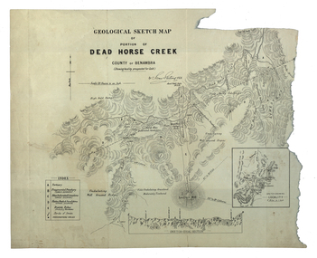
Map, Dead Horse Creek, 1887, 29/05/1887
Geological sketch map of a portion of Dead Horse Creek. WGS 84 Centroid Lat: 36 degrees 50 inches S Long: 148 degrees 00 inches S NS: 4.3km EW 4.8kmdead horse creek, james stirling, gold, geology, mount cobberas -
 Uniting Church Archives - Synod of Victoria
Symbol, Methodist Girls Comradeship 3rd Degree Symbol
Two 3rd Degree gold cross symbols. Symbol of Christ's love and service.methodist girls' comradeship -
 Melbourne Tram Museum
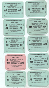
Ephemera - Set of 10 Bus Service Sandringham - Monthly Tickets, Victorian Railways (VR), 1964
Set of 10 Monthly tickets for the Sandringham based Co-ordinated Motor Coach service. See reference 165 and figure 7-78 for an example. Tickets were available for unlimited bus travel and were introduced in Sept. 1957. All dated July 1964 using blue card except for one dated June 1962 and most likely used as a training set. AF - Adult Female, AM - Adult Male 1 - Sandringham Beaumaris AF - 001, 002 2 - Sandringham Balcombe Rd AF 002, 004 and 005 3 - ditto - AM - 004, 005 4 - Sandringham - Royal Ave - AM - 001 5 - ditto - AF - 000 6 - Sandringham - Haydens Rd - June 1962, pink card - AM - unnumbered.Demonstrates a set of Victorian Railways monthly tickets used on the former Sandringham - Black Rock service replacement bus service.Set of 10 printed card tickets, all with trimmed or 45 degree corners.tickets, vr, vr trams, victorian railways, sandringham to black rock, buses, monthly -
 Frankston RSL Sub Branch
Binoculars
Binoculars of WW2 era with khaki woven canvas neck suspension strap. Scale and focus details stamped on facings and eye piecesStamped in right barrel facing V6/VFA 0220 Graticule 1/2 degree & 1/4 degree 1/2 degree & 1 degree High R.E.C./CANADA 1943 Stamped in left barrel facing No 2 Mk II Vertical Arrow C.G.B. 53 G.A. 6x30 2755 9-C 27559-C 4 2 0 2 4 graduations stamped on right and left eye pieces -
Glenelg Shire Council Cultural Collection
Document - Document - Conversion Chart, n.d
Port of Portland Authority Archivesport of portland archives -
 Trafalgar Holden Museum
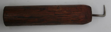
Tool - Eyelet tool
Used circa 1900 for boot makers to put lace holes in leather boots/shoesused during the late 19th and early 20th centuries for boot makingeyelet tool with wooden and metal hook bent to 90 degrees for pressing eyelet holestool, cobbler, hole making -
University of Melbourne, Burnley Campus Archives
Document - Report, W. A. Scanlan, A census of thoroughbred and standard breeders in Victoria to determine the incidence of perinatal defects in foals born in 1975 and 1976 seasons, 1977
veterinary science, masters degree, horses, foals -
Lakes Entrance Historical Society
Book - Text book, Degree Book, December 1866
Open pages divided into eight columns, NO. NAME. DATE OF INITIATION. WHITE. BLUE. SCARLET. GOLD. PURPLE. Approximately 20% used.A Degree Book from Bairnsdale District of Manchester Unity Independent Order of Oddfellows (MUIOOF).commerce -
Federation University Historical Collection
Plan, Ballarat Gaol Sewerage Plan (photocopy), 05/1927
The site of the former Ballarat gaol is now part of Federation University's SMB campus.A3 plan with 6 additional works added to original plan. The last addition was 22 August 1947. WGS 84 37 degrees 33 feet 58 inches S 143 degrees 51 feet 24 inches Eballarat gaol, arthur lasser, gaol, ballarat school of mines, buildings -
 Parks Victoria - Maldon State Battery
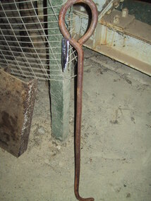
Lever
Located on-site behind the battery. It's use is unknown.Long rusty iron rod with round handle on one end, 90 degree angle on other. -
University of Melbourne, Burnley Campus Archives
Document - Report, M. E. Dietze, Radioiodine Treatment of Hyperthyroidism in the Cat, 1998
veterinary science, masters degree, cats -
Frankston RSL Sub Branch
Compass, Marching, 1918
A pocket sized marching compass enclosed in a wooden container with a hinged lid. This is a dry type compass with a floating rotary dial marked with the major and minor compass points and an outer circular dial marked from 0 to 360 degrees in 10 degrees increments. The compass container is marked J. WARDALE & Co., LONDON, 1918 No 6341. -
 Federation University Historical Collection
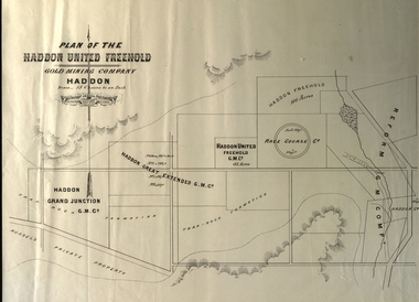
Plan, Plan of the Haddon United Freehold
Plan of the Haddon United Freehold. Scale: 15 chains to 1 inch (1:11,880) WGS 84 Centroid Lat: 37 degrees 35' 04" S Long: 143 degrees 40' 52" E NS: 2.8 km EW: 5.4 kmhaddon, plan, haddon united, haddon freehold, haddon race course co, haddon racecourse co, haddon united freehold, reform gold mining company -
Phillip Island and District Historical Society Inc.
Photograph
This photograph was taken by the Herald & Weekly Times and donated to Audrey McFee. Chicory was first grown on Phillip Island in 1870. It was used in coffee essence and for medicinal purposes.The fire in the furnace below the chicory floor. It is built up to raise a floor temperature of 300 degrees F.local history, photography, photographs, slides, film, chicory industry, black & white photograph, audrey mcfee, chicory, phillip island -
Glenelg Shire Council Cultural Collection
Photograph, n.d
Port of Portland Authority Archivesport of portland archives -
Federation University Historical Collection
Map, City of Ballarat and Borough of Sebastopol Road Map
Road map of the City of Ballarat and the Borough of Sebastopol. WGS 85 Centroid 37 degrees 33 feet 56 inches south 143 degrees 51 feet 09 inches eat E-W- extent: 9 km N-S- extent: 11.5 kmballarat, sebastopol, map, plan, ballarat shire -
 Uniting Church Archives - Synod of Victoria
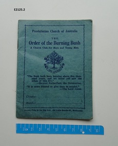
Booklet, Presbyterian Board of Religious Education, The Order of the Burning Bush and Covenant
Presbyterian Church of Australia The Order of the Burning Bush a Church club for boys and young men small, 12 page book. The book has a blue cover and contains The Rules of the Order; Commendations; The Ritual; Initiation to the First Degree; Initiation to the Second Degree and Appendix. 3rd edition.the order of the burning bush -
 Tatura Irrigation & Wartime Camps Museum
Weapon - Gunsight
Taken from a Japanese heavy machine gun after surrender at Lawas, British North Borneo. September, 1945Black Metal machine gunsight with spirit level and 2 X focusing wheels and sight and monocular. Metal base plate has 5 holes to secure to a benchLetters in metal: 27994 4 x 10 degrees To ? Jes 4? 154 on reverse No. 38458gunsight, gun, japan, dickinson, b, tatura, borneo, arms, firearms -
 Uniting Church Archives - Synod of Victoria
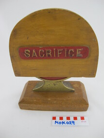
Symbol
Degree of Sacrifice symbol. Round brass symbol with wood base and wood cover. Symbol has a red background."Sacrifice"methodist order of knights -
 Whitehorse Historical Society Inc.
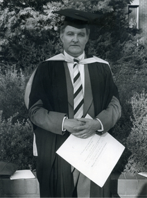
Photograph, Cr. John Madden
Black and white photo of Cr. John Madden, former Mayor of Nunawading after receiving his Master's Degree.madden, john -
University of Melbourne, Burnley Campus Archives
Negative - Colour negatives, Plant Materials, 1998
Colour photographs of plants. Negatives for Plant Materials I Degree/Diploma Weeks 1-11, 13 1998.plants, plant materials, diploma i, plant id -
 Federation University Historical Collection
Plan, Dereel Parish Plan, 1928, 16/07/1928
Parish Plan of Dereel showing crown allotments, dimensions, crown grantees, dates of grant. Scale 1:31,680 WGS 84 Centroid 37 degrees 48 feet 33 inches S 143 degrees 41 feet 46 inches S NS: 6.3km EW: 15.2kmdereel, parish plan, p. mclachlan, rifle range, j. bower, dereel lagoon, t. mellington, j. mcdonald -
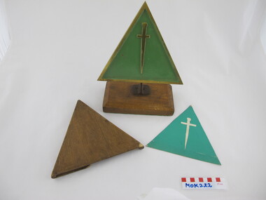 Uniting Church Archives - Synod of Victoria
Symbol
Wooden MOK Degree of Service Mark on metal and wood stand and with wooden cover. The symbol has a green card inside.methodist order of knights -
University of Melbourne, Burnley Campus Archives
Photograph - Colour prints, Plant Materials, Unknown
Envelopes containing back orders of colour photographs of plants for Degree, Diploma students, Weeks 8 and 10. Year not known.degree, diploma, students, plant id -
 Federation University Historical Collection
Plan, Haddon, County of Grenville, 1932, 13/04/1932
The Haddon Parish Plan shows crown parcels government roads, Crown Reserves, Railway. Scale 40 chains to 1" (1:31, 680) WGS 84 Centroid Lat: 37 degrees 34' 00" S Long: 148 degrees 40' 20" E N.S. 9.3km E.W.: 16.1kmhaddon, grenville, cardigan, water supply reserve, nentingbook pre-emptive right, a. mclachlan, lake burrumbeet, e.a. wynne, p. russell, b. hepburn, benjamin hepburn, nentingbool, t.c. wilson, j. amoy, william collard smith, james roach, j. mitchell -
 Bendigo Historical Society Inc.
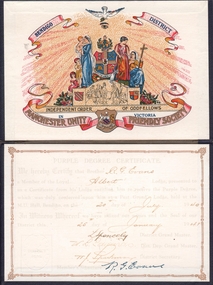
Document - PURPLE DEGREE CERTIFICATE
Each coloured degree related to a particular value of the Manchester United Oddfellows. Purple certificate was related to charity. The Bendigo chapter of the Manchester United Oddfellows began in 1854.Blu folder. On one side the coloured logo of the Independet Order of Oddfellows in Victoria, Bendigo District, Manchester Unity Friendly Society. On the other the inscription: Purple Degree Certificate - We hereby certifythat brother R. G. Evans a member of the loyal Albert lodge, presented to us a certificate from his lodge entatling him to receive the Purple Dergee, which was duly conferred upon him at a Past Grand's Lodge, held at the M. U. Hall, Bendigo on the 20th day of January 1940. In witness whereof we have affixed our names and the Seal of our district this 25th day of January 1941. Signed bt the District Grand Master: L. Spencely. Dist. Dep. Grand Master and Secretary. Memebr signature: R. G. Evans.societies, freemasons -
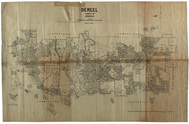
 Federation University Historical Collection
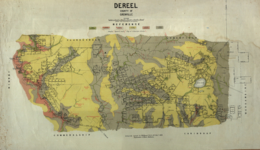
Map, Dereel, County of Grenville, 1890, 1890
Dereel is in western Victoria.Geological map of Dereel in the County of Grenville featuing six colours (predominantly grey and yellow). WGS 84 Centroid Lat: 37 degrees 48 feet 50 inches S Long:143 degrees 42 feet 10 inches S N-S: 6.4 km E-W: 15.2 km dereel, ferdinand krause, crown lands department, plan -
 Federation University Historical Collection
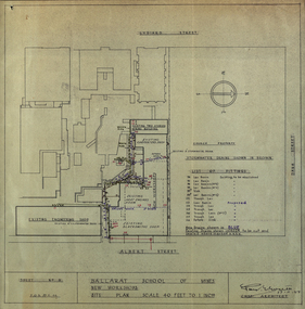
Plan - Plans, Ballarat School of Mines New Workshops, 1944, 17/11/1944
This building has been demolished to make way for new buildings along Albert Street. According to E.J. Barker this was Metal Fabrication.Plans (dyeline) for new building along the Ballarat School of Mines Albert Street frontage .1) Ballarat School of Mines New Workshops .2) as above Scale 1:480 WGS 84 37 degrees 33 feet 54 inches south 143 degrees 50 feet 30 inches eastSheet No 3 F.G.B.ballarat school of mines, metal fabrication, albert street, buildings, plan, heat engines room, model mine, blacksmiths shop, blacksmithing, carpenters shop, engineering shope, percy everett -
 Flagstaff Hill Maritime Museum and Village
Instrument - Compass, late 19th to early 20th century
This large compass is well made. It is now pitted and scratched, indication much use. Compasses were used to measure and mark out the head of the barrel by coopers. Very large compasses were used by block, spar and pump makers to help shave off angles left by axes and other tools on mast sides. Also they were used by blacksmiths in their work draftsmen, carpenters, engineers and navigators.This compass is an example of a drawing instrument that could have been used in the 19th and early 20th century by coopers and blacksmiths as well as navigators and ship smiths.Compass; large metal compass, 90-degree angle, two pointed arms hinged at the top. Inscription on the top of one arm.Stamped into the metal " J J E " ( or J J F )flagstaff hill, warrnambool, maritime village, maritime museum, flagstaff hill maritime museum & village, shipwreck coast, great ocean road, compass, drawing instrument, measuring instrument, scientific instrument, draftsman, technical drawing, navigation, engineering, blacksmith, cooper, plumber -
 Bunjil Park Aboriginal Education & Cultural Centre
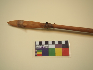
Short wooden spear with angled tail
This compound wooden spear with separate head, barb and tail is bound with resin and sinew. The tail is bound at an angle of 20 degrees to the shaft.