Showing 390 items
matching department of engineering
-
 Melbourne Tram Museum
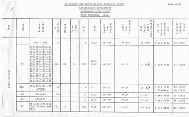
Document - Report, Melbourne & Metropolitan Tramways Board (MMTB), "Passenger Tram Fleet", 21/12/1964 12:00:00 AM
... hand corner, issued by the MMTB Engineering Department - titled... Engineering Department - titled "Passenger Tram Fleet", as at 21/12 ...Duplicated two page foolscap sheet, stapled in the top left hand corner, issued by the MMTB Engineering Department - titled "Passenger Tram Fleet", as at 21/12/1964. Lists all bogie trams, numbers, class, number in service, stored, to be sold, Tare weight, length and width, roof height, number of doors and seated / crush capacity loads. Has form G.43 in top right hand corner.trams, tramways, tramcars, lists, mmtb -
 Melbourne Tram Museum
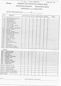
Document - Report, Melbourne & Metropolitan Tramways Board (MMTB), "MMTB - Engineering Department Running sheds Branch - Changeovers W class Trams - Form 3B" "Depot summary form for crews to report tram defects", c1980
... "MMTB - Engineering Department Running sheds Branch..., at each depot - titled - "MMTB - Engineering Department Running... depot - titled - "MMTB - Engineering Department Running sheds ...Report, single A4 sheet summary for periods showing the type of defects that change overs were made for W class trams, at each depot - titled - "MMTB - Engineering Department Running sheds Branch - Changeovers W class Trams - Form 3B" and hand written in ink on top of the sheet - "Depot summary form for crews to report tram defects". Gives some 36 reasons why a changeover may have occurred.trams, tramways, preston workshops, w class, reports, depots, faults -
 Eltham District Historical Society Inc
Photograph - Colour Print, Eltham Shire Council, Unidentified road, Eltham district, c.Oct. 1987
... Festival, 7 November 1987. 20 x 25 cm Shire of Eltham Engineering... Festival, 7 November 1987. 20 x 25 cm Shire of Eltham Engineering ...Date based on other similar display panels visible in images of the Shire of Eltham display at the Eltham Community Festival, 7 November 1987. 20 x 25 cm Shire of Eltham Engineering Department Providing the resources to undertake • Survey, design, consultation • Road construction and maintenance • Bridge construction and maintenance • Street sweeping • Drain and pit cleaning • Traffic engineering installation and maintenance • Garbage collection • Tip management, land reclamation and beautification • Maintenance of community buildings • Provision of community and recreation facilitiesunidentified, display panel, eltham festival, footpaths and gutters, infrastructure, residential, roads, shire of eltham, streets, 1987 -
 Federation University Historical Collection
Document - Document - Design, E J Barker: Ballarat College of Advanced Education: Final Year Project Report; "Internal Combustion Engine Driven Heat Pump", 1984
... Mechanical Engineering Department Ballarat C.A.E. Final... Mechanical Engineering Department Ballarat C.A.E. Final Year Report ...Mechanical Engineering Department Ballarat C.A.E. Final Year Report submitted by John Barker, 1984. The Report was "Internal Combustion Engine Driven Heat Pump". His supervisor was L E Taylor. The location of the experimental rig was in the Thermodynamics Laboratory at Ballarat Council of Advanced Education. This project involved the design, construction and limited testing of an Internal Combustion Engine Driven Heat Pump, utilising full waste heat recovery, for the purpose of heating mains supply water. John is the son of Jack Barker, foundation director of Ballarat College of Advanced Education.75 page report - typed with photos and diagrams. 38 pages - Appendix 1-8engineering, vice principal, foundation director, ballarat college of advanced education, bcae, mount helen campus, engineering drawing, design, manufacture, heat engines, internal combustion engine, report, supervisor, l e taylor, john barker, internal combustion engine driven heat pump, heat recovery, thermodynamics laboratory -
 Melbourne Tram Museum
Document - Instruction, Melbourne & Metropolitan Tramways Board (MMTB), "Duties of Electrical Mechanics - Runningsheds", May. 1970
... "MMTB Engineering Department - Workshops and Running Shed Branch... sheets - headed "MMTB Engineering Department - Workshops ...Instruction - 5 pages - duplicated foolscap sheets - headed "MMTB Engineering Department - Workshops and Running Shed Branch" - titled "Duties of Electrical Mechanics - Runningsheds" Details electrical work to be done on tramcars at the 100 hours service; trolley pole, electrical equipment, controllers, switches, resistance boxes, line breakers, RC units, motors, governor, compressor, lighting, buzzers, door engines, wipers, brake cylinders and general body eg handrails. Dated May 1970.trams, tramways, depot, safety, workshops, electrical equipment, instructions, procedures -
 Melbourne Tram Museum
Document - Tender Document, Melbourne & Metropolitan Tramways Board (MMTB), "Engineering Department - Planning Branch - Modal Interchange Investigations 1974 - 1975", 1975
... "Engineering Department - Planning Branch - Modal... titled "Engineering Department - Planning Branch - Modal... "Engineering Department - Planning Branch - Modal Interchange ...Comb bound (brown plastic) report, manila card covers, approx. 10 pages, plus yellow sheets plus four folded drawings titled "Engineering Department - Planning Branch - Modal Interchange Investigations 1974 - 1975". Study looks at five possible modal interchanges: 1. - Box Hill Railway Station 2. - High St / Harp Road, Kew 3. - St Kilda Road / Park St / Domain Road 4 - Swanston St and Flinders St station 5 - Blackburn Railway station.In red felt pen on top right hand corner "(118)". Has stamp "Discarded from PTC Library 22 Oct. 1989" on front cover and the first sheet.trams, tramways, mmtb, tram stops, railways, domain junction, swanston st, flinders st station, blackburn -
 Melbourne Tram Museum
Document - Report, Melbourne & Metropolitan Tramways Board (MMTB), "Chopper Control for Trams", 1977
... (Planning and Research) Act 1974, prepared by the MMTB Engineering... and Research) Act 1974, prepared by the MMTB Engineering Department ...Report - 149 A4 pages, brown comb bound, orange card covers with two pasted on labels on the front cover. Titled "Chopper Control for Trams". Funded by the Australian Government Transport (Planning and Research) Act 1974, prepared by the MMTB Engineering Department Technical Services Department. Gives an introduction to chopper control technology, summary of the findings of the study, 25% saving in energy. Has a table of contents on page 8, many graphs, including impact of regeneration on W class tram, electromagnetic impact and many photographs of the test equipment. Includes the test program.Front and back covers stamped "Tramway Workshop Library Preston", and in top right hand corner in ink "(Z Tram #5) (1977) " and in pencil "Spare Copy"trams, tramways, mmtb, reports, testing, preston workshops, chopper control, controllers, z class, tram 5 -
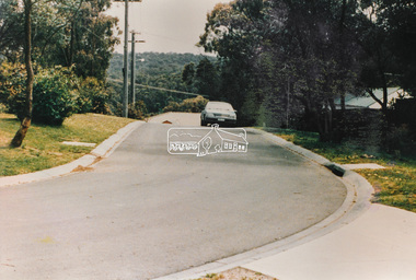
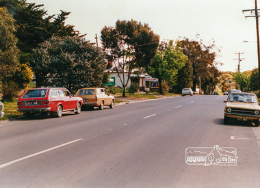 Eltham District Historical Society Inc
Photograph, Looking west near 942 Main Road, Hurstbridge, c. Oct 1987, 1987
... of Eltham Engineering Department Providing the resources... of Eltham Engineering Department Providing the resources ...Yvonne's Dressmaking and Alteration Service at 942 Main Road. Formerly a bakery, the building was demolished in 1990 and is now the site of Hurstbridge Saddlery. The milkbar is down the road, brick wall with a blue sign on it. There's still an older house next to the milkbar, but that's hidden from view in this shot as it's further back from the road. Date based on other similar display panels visible in images of the Shire of Eltham display at the Eltham Community Festival, 7 November 1987. Shire of Eltham Engineering Department Providing the resources to undertake • Survey, design, consultation • Road construction and maintenance • Bridge construction and maintenance • Street sweeping • Drain and pit cleaning • Traffic engineering installation and maintenance • Garbage collection • Tip management, land reclamation and beautification • Maintenance of community buildings • Provision of community and recreation facilitiesPhoto print mounted on carddisplay panel, eltham festival, heidelberg-kinglake road, hurstbridge, hurstbridge milk bar, infrastructure, main road, mm, shire of eltham, yvonne's dressmaking and alteration service -
 Federation University Historical Collection
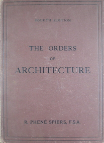
Book - Books, Spiers, R. Phene, The Order Of Architecture: Greek, Roman, and Italian, 1902 (exact)
... was educated in the engineering department of King's College, London... in the engineering department of King's College, London and at the atelier ...A large brown hardcover book. Title and author's name are written in black on front cover and in gold on spine. This is the 4th ed., containing twenty-seven plates. It includes a preface to 4th and 1st ed., a list of plates, 20 p. of text and a list of references. This book contains a selection of architectural designs of the Orders as employed in ancient buildings.r phene spiers, greek roman italian architecture, the doric order, the ionic order, the corinthian order, the composite order, the temple of theseus athens, the theatre of marcellus rome, temple of vespasian rome, library plate, book plate -
Federation University Historical Collection
Document - Document - Proposal, VIOSH : Ballarat College of Advanced Education; Proposal for a Post-Graduate Diploma Course in OHM, 1977
... head of department od mechanical engineering... of School of Engineering; Tom Norwood, Head of Department... of School of Engineering; Tom Norwood, Head of Department ...Victorian Institute of Occupational Safety and Health (VIOSH) Australia is the Asia-Pacific centre for teaching and research in occupational health and safety (OHS) and is known as one of Australia's leaders on the field. VIOSH has a global reputation for its innovative approach within the field of OHS management. VIOSH had its first intake of students in 1979. At that time the Institution was known as the Ballarat College of Advanced Education. In 1990 it became known as Ballarat University College, then in 1994 as University of Ballarat. It was 2014 that it became Federation University. VIOSH Australia students are safety managers, senior advisors and experienced OHS professionals. They come from all over Australia and industry. Students are taught active research and enquiry; rather than textbook learning and a one-size fits all approach. VIOSH accepts people into the Graduate Diploma of Occupational Hazard Management who have no undergraduate degree - on the basis of extensive work experience and knowledge. Documents relate to the planning for the introduction of a Graduate Diploma in Occupational Safety and Health to begin in 1978. It was developed for the Victorian Institute of Colleges 1977-81 Academic Master Plan. The working party submitted a Third Draft in April 1977. The Course Co-ordinator was Derek Viner, Senior Lecturer, School of Engineering. The internal working party was Dr E Phillips, Head of School of Applied Science; Derek Woolley, Head of School of Engineering; Tom Norwood, Head of Department of Mechanical Engineering; Max Brooke, School of Business Studies; G Fernandez, School of Business Studies; J Harvey, School of Applied Science; B Rollins, School of Community and General Studies. An External Advisory Panel was also formed was different safety and injury bodies. Eric Wigglesworth - Injury Research Project became lectured at BCAE when the course began.Typed pages - A4 and foolscapviosh, victorian institute of occupational safety and health, graduate diploma in occupational safety and health, victorian institute of colleges, academic master plan, derek viner, course co-ordinator, school of engineering, dr e phillips, head of applied science, internal working party, derek woolley, head of school of engineering, tom norwood, head of department od mechanical engineering, max brooke, school of business studies, g fernandez, j harvey, school of applied science, b rollins, school of community and general studies, external woking party, s barklay, loss control officer, dr w cooper, medical officer gmh, f davis, risk management consultant, w jinkins, industrial safety advisory council, h jones, f mccabe, c polglaze, sec, w spratt, royal insurance co., f turley, national safety council victoria, eric wigglesworth, royal australian college of surgeons, c willis, loss control consultant -
 Kew Historical Society Inc
Plan, Melbourne & Metropolitan Board of Works : Borough of Kew : Detail Plan No.1592, 1905
... working in the Engineering Department of the Borough and later... working in the Engineering Department of the Borough and later ...The Melbourne and Metropolitan Board of Works (MMBW) plans were produced from the 1890s to the 1950s. They were crucial to the design and development of Melbourne's sewerage and drainage system. The plans, at a scale of 40 feet to 1 inch (1:480), provide a detailed historical record of Melbourne streetscapes and environmental features. Each plan covers one or two street blocks (roughly six streets), showing details of buildings, including garden layouts and ownership boundaries, and features such as laneways, drains, bridges, parks, municipal boundaries and other prominent landmarks as they existed at the time each plan was produced. (Source: State Library of Victoria). This plan forms part of a large group of MMBW plans and maps that was donated to the Society by the Mr Poulter, City Engineer of the City of Kew in 1989. Within this collection, thirty-five hand-coloured plans, backed with linen, are of statewide significance as they include annotations that provide details of construction materials used in buildings in the first decade of the 20th century as well as additional information about land ownership and usage. The copies in the Public Record Office Victoria and the State Library of Victoria are monochrome versions which do not denote building materials so that the maps in this collection are invaluable and unique tools for researchers and heritage consultants. A number of the plans are not held in the collection of the State Library of Victoria so they have the additional attribute of rarity.Original survey plan, issued by the MMBW to a contractor with responsibility for constructing sewers in the area identified on the plan within the Borough of Kew. The plan was at some stage hand-coloured, possibly by the contractor, but more likely by officers working in the Engineering Department of the Borough and later Town, then City of Kew. The hand-coloured sections of buildings on the plan were used to denote masonry or brick constructions (pink), weatherboard constructions (yellow), and public buildings (grey). In MMBW Plan No.1592, the pink line indicates that area of the plan for which the contracting engineer was responsible. Included in the Plan are a number of primarily brick villas in a section of Belmont Avenue off Cotham Road. The house ‘Uvadale’ north of Belmont Avenue, and facing Cotham Road is also included in the contract. Excluded from the contract but shown on the Plan are ‘Glendonald’, ‘Mont Belmont’ and ‘Gilden’.melbourne and metropolitan board of works, detail plans, survey plans - borough of kew, mmbw 1592, cartography -
 Kew Historical Society Inc
Plan, Melbourne & Metropolitan Board of Works : Borough of Kew : Detail Plan No.1561, 1905
... working in the Engineering Department of the Borough and later... likely by officers working in the Engineering Department ...The Melbourne and Metropolitan Board of Works (MMBW) plans were produced from the 1890s to the 1950s. They were crucial to the design and development of Melbourne's sewerage and drainage system. The plans, at a scale of 40 feet to 1 inch (1:480), provide a detailed historical record of Melbourne streetscapes and environmental features. Each plan covers one or two street blocks (roughly six streets), showing details of buildings, including garden layouts and ownership boundaries, and features such as laneways, drains, bridges, parks, municipal boundaries and other prominent landmarks as they existed at the time each plan was produced. (Source: State Library of Victoria). This plan forms part of a large group of MMBW plans and maps that was donated to the Society by Mr Poulter, City Engineer of the City of Kew in 1989. Within this collection, thirty-five hand-coloured plans, backed with linen, are of statewide significance as they include annotations that provide details of construction materials used in buildings in the first decade of the 20th century as well as additional information about land ownership and usage. The copies in the Public Record Office Victoria and the State Library of Victoria are monochrome versions which do not denote building materials so that the maps in this collection are invaluable and unique tools for researchers and heritage consultants. A number of the plans are not held in the collection of the State Library of Victoria so they have the additional attribute of rarity.Original survey plan, issued by the MMBW to a contractor with responsibility for constructing sewers in the area identified on the plan within the Borough of Kew. The plan was at some stage hand-coloured, possibly by the contractor, but more likely by officers working in the Engineering Department of the Borough and later Town, then City of Kew. The hand-coloured sections of buildings on the plan were used to denote masonry or brick constructions (pink), weatherboard constructions (yellow), and public buildings (grey). MMBW Detail Plan 1561 outlines those residences in the area bordered by Burke Road, Loxton Street, Mount Street and Barkers Road that had been constructed by 1905 when the land was surveyed. At this time, the area nearest Burke Road had been subdivided and developed whereas the lands to the west were as yet undeveloped. The houses represented are not named on the Plan.melbourne and metropolitan board of works, detail plans, mmbw 1561, cartography -
 Kew Historical Society Inc
Plan, Melbourne & Metropolitan Board of Works : Borough of Kew : Detail Plan No.1302, 1910
... working in the Engineering Department of the Borough and later... likely by officers working in the Engineering Department ...The Melbourne and Metropolitan Board of Works (MMBW) plans were produced from the 1890s to the 1950s. They were crucial to the design and development of Melbourne's sewerage and drainage system. The plans, at a scale of 40 feet to 1 inch (1:480), provide a detailed historical record of Melbourne streetscapes and environmental features. Each plan covers one or two street blocks (roughly six streets), showing details of buildings, including garden layouts and ownership boundaries, and features such as laneways, drains, bridges, parks, municipal boundaries and other prominent landmarks as they existed at the time each plan was produced. (Source: State Library of Victoria)This plan forms part of a large group of MMBW plans and maps that was donated to the Society by the Mr Poulter, City Engineer of the City of Kew in 1989. Within this collection, thirty-five hand-coloured plans, backed with linen, are of statewide significance as they include annotations that provide details of construction materials used in buildings in the first decade of the 20th century as well as additional information about land ownership and usage. The copies in the Public Record Office Victoria and the State Library of Victoria are monochrome versions which do not denote building materials so that the maps in this collection are invaluable and unique tools for researchers and heritage consultants. A number of the plans are not held in the collection of the State Library of Victoria so they have the additional attribute of rarity.Original survey plan, issued by the MMBW to a contractor with responsibility for constructing sewers in the area identified on the plan within the Borough of Kew. The plan was at some stage hand-coloured, possibly by the contractor, but more likely by officers working in the Engineering Department of the Borough and later Town, then City of Kew. The hand-coloured sections of buildings on the plan were used to denote masonry or brick constructions (pink), weatherboard constructions (yellow), and public buildings (grey). The absence of buildings and or property in Kew facing the Yarra is the most notable feature of this plan. Walmer Street and its bridge stretched, then and now, from Studley Park Road to Victoria Street, Richmond. On the Richmond side of the Yarra, there was evidence in 1904 of industry (‘Wool shed’; Soap Works’) and entertainment (‘Skittle Alley’). In reality, another Plan (No.1303) shows Chinese Gardens bordering the Yarra on the Kew side and buildings in Young Street.melbourne and metropolitan board of works, detail plans, mmbw 1302, cartography -
 Kew Historical Society Inc
Plan, Melbourne & Metropolitan Board of Works : Borough of Kew : Detail Plan No.1571, 1904
... working in the Engineering Department of the Borough and later... likely by officers working in the Engineering Department ...The Melbourne and Metropolitan Board of Works (MMBW) plans were produced from the 1890s to the 1950s. They were crucial to the design and development of Melbourne's sewerage and drainage system. The plans, at a scale of 40 feet to 1 inch (1:480), provide a detailed historical record of Melbourne streetscapes and environmental features. Each plan covers one or two street blocks (roughly six streets), showing details of buildings, including garden layouts and ownership boundaries, and features such as laneways, drains, bridges, parks, municipal boundaries and other prominent landmarks as they existed at the time each plan was produced. (Source: State Library of Victoria)This plan forms part of a large group of MMBW plans and maps that was donated to the Society by the Mr Poulter, City Engineer of the City of Kew in 1989. Within this collection, thirty-five hand-coloured plans, backed with linen, are of statewide significance as they include annotations that provide details of construction materials used in buildings in the first decade of the 20th century as well as additional information about land ownership and usage. The copies in the Public Record Office Victoria and the State Library of Victoria are monochrome versions which do not denote building materials so that the maps in this collection are invaluable and unique tools for researchers and heritage consultants. A number of the plans are not held in the collection of the State Library of Victoria so they have the additional attribute of rarity.Original survey plan, issued by the MMBW to a contractor with responsibility for constructing sewers in the area identified on the plan within the Borough of Kew. The plan was at some stage hand-coloured, possibly by the contractor, but more likely by officers working in the Engineering Department of the Borough and later Town, then City of Kew. The hand-coloured sections of buildings on the plan were used to denote masonry or brick constructions (pink), weatherboard constructions (yellow), and public buildings (grey). This plan is the other half of Plan No.1571 representing the constructions to the west of Wellington Street before and in 1903/4. This plan represents the built environment in Edgevale Road, Wellington Street, Atkins Street, Annadale Street, Mortimer Street, and Cotham Road. Whereas there are smaller allotments and more modest housing stock facing Edgevale Road, larger blocks and more substantial houses are represented facing Cotham Road.melbourne and metropolitan board of works, detail plans, mmbw 1571, cartography -
 Kew Historical Society Inc
Plan, Melbourne & Metropolitan Board of Works : Borough of Kew : Detail Plan No.1575, 1905
... working in the Engineering Department of the Borough and later... by the contractor, but more likely by officers working in the Engineering ...The Melbourne and Metropolitan Board of Works (MMBW) plans were produced from the 1890s to the 1950s. They were crucial to the design and development of Melbourne's sewerage and drainage system. The plans, at a scale of 40 feet to 1 inch (1:480), provide a detailed historical record of Melbourne streetscapes and environmental features. Each plan covers one or two street blocks (roughly six streets), showing details of buildings, including garden layouts and ownership boundaries, and features such as laneways, drains, bridges, parks, municipal boundaries and other prominent landmarks as they existed at the time each plan was produced. (Source: State Library of Victoria)This plan forms part of a large group of MMBW plans and maps that was donated to the Society by the Mr Poulter, City Engineer of the City of Kew in 1989. Within this collection, thirty-five hand-coloured plans, backed with linen, are of statewide significance as they include annotations that provide details of construction materials used in buildings in the first decade of the 20th century as well as additional information about land ownership and usage. The copies in the Public Record Office Victoria and the State Library of Victoria are monochrome versions which do not denote building materials so that the maps in this collection are invaluable and unique tools for researchers and heritage consultants. A number of the plans are not held in the collection of the State Library of Victoria so they have the additional attribute of rarity.Original survey plan, issued by the MMBW to a contractor with responsibility for constructing sewers in the area identified on the plan within the Borough of Kew. The plan was at some stage hand-coloured, possibly by the contractor, but more likely by officers working in the Engineering Department of the Borough and later Town, then City of Kew. The hand-coloured sections of buildings on the plan were used to denote masonry or brick constructions (pink), weatherboard constructions (yellow), and public buildings (grey). Plan No.1575 shows that in the area bounded by Wellington Street, Edgevale Road, Glenferrie Road, and Cotham Road, there had already been significant subdivision of land and houses constructed. As one of the highest points in Kew, as expected, there were already some significant mansions built on large allotments of land. Many of these mansions are identified by name on the plan such as ‘Kelso’, ‘Abbotsford’, ‘Clarendon’ and ‘Ashlyn’ in Cotham Road. Other houses of equal size are unnamed on the plan.melbourne and metropolitan board of works, detail plans, maps - borough of kew, mmbw 1575, cartography -
 Warrnambool and District Historical Society Inc.
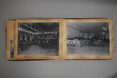
Publication, Photo album Robinson's Motors, C 1910
... the workshop show the engineering department, Body Making, painting... the engineering department, Body Making, painting and smith's shop ...Alexander Robinson was born on the 19th March 1862 and lived on the family farm, Woody Park at Aitkins Gully Warrnambool. At 18 he moved into Warrnambool and began his coach building and automotive career with Fred Morse who was one of Warrnambool's earliest coachbuilders. The business which was situated in Fairy Street was later taken over by Callaghan Motors who operated from the same site until 2017. He married Miss Lydia Humm and they had five children. He was active in community affairs and was Mayor of Warrnambool from 1907-1909. He died in September 1932. This album has photographs dating from 1907 up to 1913 and show a variety of early motor vehicles, workers and machinery. Individual photos have names of owners some of which include John j Winter, June 1912,Dr J H Henderson August 1911, D Ronaldson Ballarat 1912, Edward Owen 1913 martin Brennan 1914. The sections inside the workshop show the engineering department, Body Making, painting and smith's shop. There are also a number of Vulcan cars for which they were agents. This album is a valuable source of early motor industry history in Warrnambool. There are many local scenes as backdrops to the vehicles . Unfortunately there are no names of people in the photos.Rectangular dark green cloth covered album which has black tape down the spine. It contains a number of photographs relating to Robinson's Motors as well as newspaper cutting. There are a number of pages which are blank.Inside front cover: handwritten " Robinson's Motor Propty Limited Warrnambool.robinson motors, warrnambool, alexander robinson, robinson coachbuilders warrnambool -
 Kew Historical Society Inc
Plan, Melbourne and Metropolitan Board of Works, Borough of Kew : Detail Plan No.1562, 1905
... working in the Engineering Department of the Borough and later... likely by officers working in the Engineering Department ...The Melbourne and Metropolitan Board of Works (MMBW) plans were produced from the 1890s to the 1950s. They were crucial to the design and development of Melbourne's sewerage and drainage system. The plans, at a scale of 40 feet to 1 inch (1:480), provide a detailed historical record of Melbourne streetscapes and environmental features. Each plan covers one or two street blocks (roughly six streets), showing details of buildings, including garden layouts and ownership boundaries, and features such as laneways, drains, bridges, parks, municipal boundaries and other prominent landmarks as they existed at the time each plan was produced. (Source: State Library of Victoria). This plan forms part of a large group of MMBW plans and maps that was donated to the Society by the Mr Poulter, City Engineer of the City of Kew in 1989. Within this collection, thirty-five hand-coloured plans, backed with linen, are of statewide significance as they include annotations that provide details of construction materials used in buildings in the first decade of the 20th century as well as additional information about land ownership and usage. The copies in the Public Record Office Victoria and the State Library of Victoria are monochrome versions which do not denote building materials so that the maps in this collection are invaluable and unique tools for researchers and heritage consultants. A number of the plans are not held in the collection of the State Library of Victoria so they have the additional attribute of rarity.Original survey plan, issued by the MMBW to a contractor with responsibility for constructing sewers in the area identified on the plan within the Borough of Kew. The plan was at some stage hand-coloured, possibly by the contractor, but more likely by officers working in the Engineering Department of the Borough and later Town, then City of Kew. The hand-coloured sections of buildings on the plan were used to denote masonry or brick constructions (pink), weatherboard constructions (yellow), and public buildings (grey). MMBW detail plan No.1562, in contrast to No.1561 includes the names of a large number of houses: in Barkers Road: ‘Ashwick’, ‘Owasso’, ‘Anadiha’, ‘Eurobin’, ‘Carlsruhe’, ‘Arlington’ and ‘Altyre’. Unnamed but clearly represented on the plan is what was then known as the ‘Auburn Heights Recreation Club’, which at this stage included a Bowling Green, a Croquet Green and two Tennis Courts. On the plan, Brougham Place, as it was then known, is represented. It was later renamed Daniell Place. The aforementioned Arlington is now the junior campus of Preshil. melbourne and metropolitan board of works, detail plans, mmbw 1562, cartography -
 Melbourne Tram Museum
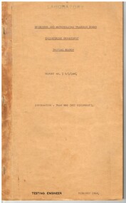
Document - Report, Melbourne & Metropolitan Tramways Board (MMTB), "Information - Tram 980 (PCC Equipment)", Feb. 1964
... Engineering Department Testing Department Report No. I 5/1/144... Equipment)", dated February 1964, prepared by the MMTB Engineering ...Report - carbon typed copy - 43 foolscap sheets bound within a brown card folder, stapled, with signs of an adhesive tape binding on the outside. Titled "Information - Tram 980 (PCC Equipment)", dated February 1964, prepared by the MMTB Engineering Department Testing Department Report No. I 5/1/144. Signed by W. Hines 6/2/64, report prepared by CLF. Provides a synopsis of the report, purpose of investigation, design, operational history, time in workshops, maintenance program, schedule speeds, riding qualities, has appendices with design modification, list of time in workshops, PCC tramcars maintenance program, workshops maintenance of ten typical trams, MMTB Tramcar Schedule speeds. Includes photographs of the failure of the main body transom and the replacement one, and two graphs. Second copy added 31-5-2016 from donation of Geoff Warburton. This copy - has red binding tape.trams, tramways, testing, pcc, preston workshops, reports, specification, tramcar manufacture, tramcar design, maintenance, tram 980 -
 Kew Historical Society Inc
Plan, Melbourne & Metropolitan Board of Works : Borough of Kew : Detail Plan No.1578, 1904
... working in the Engineering Department of the Borough and later... by the contractor, but more likely by officers working in the Engineering ...The Melbourne and Metropolitan Board of Works (MMBW) plans were produced from the 1890s to the 1950s. They were crucial to the design and development of Melbourne's sewerage and drainage system. The plans, at a scale of 40 feet to 1 inch (1:480), provide a detailed historical record of Melbourne streetscapes and environmental features. Each plan covers one or two street blocks (roughly six streets), showing details of buildings, including garden layouts and ownership boundaries, and features such as laneways, drains, bridges, parks, municipal boundaries and other prominent landmarks as they existed at the time each plan was produced. (Source: State Library of Victoria). This plan forms part of a large group of MMBW plans and maps that was donated to the Society by the Mr Poulter, City Engineer of the City of Kew in 1989. Within this collection, thirty-five hand-coloured plans, backed with linen, are of statewide significance as they include annotations that provide details of construction materials used in buildings in the first decade of the 20th century as well as additional information about land ownership and usage. The copies in the Public Record Office Victoria and the State Library of Victoria are monochrome versions which do not denote building materials so that the maps in this collection are invaluable and unique tools for researchers and heritage consultants. A number of the plans are not held in the collection of the State Library of Victoria so they have the additional attribute of rarity.Original survey plan, issued by the MMBW to a contractor with responsibility for constructing sewers in the area identified on the plan within the Borough of Kew. The plan was at some stage hand-coloured, possibly by the contractor, but more likely by officers working in the Engineering Department of the Borough and later Town, then City of Kew. The hand-coloured sections of buildings on the plan were used to denote masonry or brick constructions (pink), weatherboard constructions (yellow), and public buildings (grey). MMBW Plan No.1578 is significant in that it defines the extent of two private schools: Xavier College and Kew High School (now part of Trinity Grammar) by 1904. In relation to the latter, the plan clarifies which buildings the High School operated from behind the mansion ‘Molina’. Established in 1902, Trinity Grammar was to later lease and subsequently buy Molina (now ‘Merritt House’) and ‘Elsinore’ (now ‘Roberts House’). Xavier College had been established in 1872. This 1904 plan delineates the West Wing and the Great Hall (built in 1890).melbourne and metropolitan board of works, detail plans, maps - borough of kew, mmbw 1578, cartography -
 Kew Historical Society Inc
Plan, Melbourne & Metropolitan Board of Works : Borough of Kew : Detail Plan No.1590, 1905
... working in the Engineering Department of the Borough and later... working in the Engineering Department of the Borough and later ...The Melbourne and Metropolitan Board of Works (MMBW) plans were produced from the 1890s to the 1950s. They were crucial to the design and development of Melbourne's sewerage and drainage system. The plans, at a scale of 40 feet to 1 inch (1:480), provide a detailed historical record of Melbourne streetscapes and environmental features. Each plan covers one or two street blocks (roughly six streets), showing details of buildings, including garden layouts and ownership boundaries, and features such as laneways, drains, bridges, parks, municipal boundaries and other prominent landmarks as they existed at the time each plan was produced. (Source: State Library of Victoria)This plan forms part of a large group of MMBW plans and maps that was donated to the Society by the Mr Poulter, City Engineer of the City of Kew in 1989. Within this collection, thirty-five hand-coloured plans, backed with linen, are of statewide significance as they include annotations that provide details of construction materials used in buildings in the first decade of the 20th century as well as additional information about land ownership and usage. The copies in the Public Record Office Victoria and the State Library of Victoria are monochrome versions which do not denote building materials so that the maps in this collection are invaluable and unique tools for researchers and heritage consultants. A number of the plans are not held in the collection of the State Library of Victoria so they have the additional attribute of rarity.Original survey plan, issued by the MMBW to a contractor with responsibility for constructing sewers in the area identified on the plan within the Borough of Kew. The plan was at some stage hand-coloured, possibly by the contractor, but more likely by officers working in the Engineering Department of the Borough and later Town, then City of Kew. The hand-coloured sections of buildings on the plan were used to denote masonry or brick constructions (pink), weatherboard constructions (yellow), and public buildings (grey). Surveyed by the Board of Works in 1903 and published in 1904, Plan No.1590 shows development north of Cotham Road. While this plan includes built structures in Mary Street, Cotham Road, High Street, Park Hill Road, Kent Street, Ridgeway Avenue, and Ermington Lane (now Ermington Place), only part of this section was notated and coloured in this contractor’s copy. Numerous houses, large and small are named on the plan: ‘Cholula’, ‘Belper’, ‘The Uplands’, ‘Spring Grove’ facing Cotham Road; ‘Marion’ facing Kent Street; and ‘Kia Ora’ facing Ridgeway Avenue.melbourne and metropolitan board of works, detail plans, mmbw 1590, survey plans - borough of kew, cartography -
 Federation University Historical Collection
Book - Book - Handbook, VIOSH: BCAE Graduate Diploma in Occupational Hazard Management; ES Risk Engineering, Derek Viner,1986
... , specifically in Engineering. Checklists for various situations..., specifically in Engineering. Checklists for various situations ...Victorian Institute of Occupational Safety and Health (VIOSH) Australia is the Asia-Pacific centre for teaching and research in occupational health and safety (OHS) and is known as one of Australia's leaders on the field. VIOSH has a global reputation for its innovative approach within the field of OHS management. VIOSH had its first intake of students in 1979. At that time the Institution was known as the Ballarat College of Advanced Education. In 1990 it became known as Ballarat University College, then in 1994 as University of Ballarat. It was 2014 that it became Federation University. "It is always better as a matter of principle to remove the hazard from a design rather than subsequently develop safeguards for the design". This may not always be possible. This book looks at safeguard designs and applications, specifically in Engineering. Checklists for various situations are enclosed. This book has been written by Derek Viner - Engineering Department at BCAE and Consultant VIOSH Australia students are safety managers, senior advisors and experienced OHS professionals. They come from all over Australia and industry. Students are taught active research and enquiry; rather than textbook learning and a one-size fits all approach. VIOSH accepts people into the Graduate Diploma of Occupational Hazard Management who have no undergraduate degree - on the basis of extensive work experience and knowledge. A4 size book of 105 printed pages - spiral bound. Divided into seven sections by yellow paper. Yellow cover.viosh, victorian institute of occupational safety and health, ballarat college of advanced education, graduate diploma in occupational hazard management, es472 risk engineering, derek viner, safeguard designs, applications, checklists -
 Bendigo Military Museum
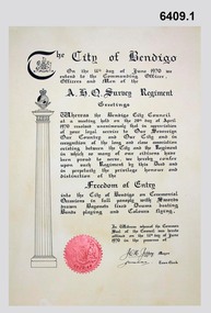
Certificate - Army Survey Regiment City of Bendigo Freedom of Entry Certificate 1970, Ian Wallace and AHQ Survey Regiment, Bendigo, June 1970
... Engineering Department. The Freedom of Entry to the City was first... Engineering Department. The Freedom of Entry to the City was first ...The certificate was issued by the City of Bendigo to AHQ Survey Regiment awarding the Regiment "Freedom of Entry" on ceremonial occasions. The certificate recognises the long service and close association between the Regiment and the City. Three certificates with seals were produced. One held by the City of Bendigo, one held by the Regiment and one was held by Ian Wallace who produced the certificates when he was part of the City's Engineering Department. The Freedom of Entry to the City was first conferred by the Bendigo City Council to the Army Survey Regiment in 1970. The unit then exercised its freedom by marching into the city with swords drawn, bayonets fixed and drums beating. The honour is usually bestowed upon local regiments, in recognition of their dedicated service, and it is common for military units to periodically exercise their freedom by arranging a parade through the city. The parade generally concluded after formal inspections of the troops. Regiment members were often treated to a civic reception at the City Hall after the ceremony. The Regiment also exercised its Freedom of Entry with anniversary parades in 1977, 1980, 1985, 1990 and 1995.The Regiment copy of the certificate was sent to the Army Military Museum at Holsworthy when the unit was disbanded and this copy (6409.1) held in the Bendigo RSL Museum is the copy that was originally held by the City of Bendigo. 6409.2 is a photograph of Gary Warnest, President ExFortuna Survey Association (left) holding the certificate 6409.1 and Mr Ian Wallace the certificate producer (right).Large framed certificate. Wooden frame, glass protecting the certificate.royal australian survey corps, rasvy, fortuna, army survey regiment, army svy regt, asr -
 Kew Historical Society Inc
Plan, Melbourne & Metropolitan Board of Works : Borough of Kew : Detail Plan No.1350, 1910
... working in the Engineering Department of the Borough and later... likely by officers working in the Engineering Department ...The Melbourne and Metropolitan Board of Works (MMBW) plans were produced from the 1890s to the 1950s. They were crucial to the design and development of Melbourne's sewerage and drainage system. The plans, at a scale of 40 feet to 1 inch (1:480), provide a detailed historical record of Melbourne streetscapes and environmental features. Each plan covers one or two street blocks (roughly six streets), showing details of buildings, including garden layouts and ownership boundaries, and features such as laneways, drains, bridges, parks, municipal boundaries and other prominent landmarks as they existed at the time each plan was produced. (Source: State Library of Victoria). This plan forms part of a large group of MMBW plans and maps that was donated to the Society by the Mr Poulter, City Engineer of the City of Kew in 1989. Within this collection, thirty-five hand-coloured plans, backed with linen, are of statewide significance as they include annotations that provide details of construction materials used in buildings in the first decade of the 20th century as well as additional information about land ownership and usage. The copies in the Public Record Office Victoria and the State Library of Victoria are monochrome versions which do not denote building materials so that the maps in this collection are invaluable and unique tools for researchers and heritage consultants. A number of the plans are not held in the collection of the State Library of Victoria so they have the additional attribute of rarity.Original survey plan, issued by the MMBW to a contractor with responsibility for constructing sewers in the area identified on the plan within the Borough of Kew. The plan was at some stage hand-coloured, possibly by the contractor, but more likely by officers working in the Engineering Department of the Borough and later Town, then City of Kew. The hand-coloured sections of buildings on the plan were used to denote masonry or brick constructions (pink), weatherboard constructions (yellow), and public buildings (grey). MMBW Plan No. 1350 depicts the western end of Studley Park on the north side of the Studley Park Road. ‘Raheen’, then the home of Sir Henry Wrixon is named, the plan identifying those parts of the house that were built of brick and timber. The two houses between Raheen and the River Yarra are also shown. Other parts of the plan show neighbouring streets: Yarra Street, Studley Park Avenue, Studley Street and Fenwick Street. Each, apart from Fenwick Street was subsequently renamed. At the corner of Fenwick and Stawell Streets, the home of Joseph Butterworth Coombs, later called ‘Hope Mansell’, is represented but unnamed.melbourne and metropolitan board of works, detail plans, mmbw 1350, cartography -
 Kew Historical Society Inc
Plan, Melbourne & Metropolitan Board of Works : Borough of Kew : Detail Plan No.1565, 1905
... working in the Engineering Department of the Borough and later... likely by officers working in the Engineering Department ...The Melbourne and Metropolitan Board of Works (MMBW) plans were produced from the 1890s to the 1950s. They were crucial to the design and development of Melbourne's sewerage and drainage system. The plans, at a scale of 40 feet to 1 inch (1:480), provide a detailed historical record of Melbourne streetscapes and environmental features. Each plan covers one or two street blocks (roughly six streets), showing details of buildings, including garden layouts and ownership boundaries, and features such as laneways, drains, bridges, parks, municipal boundaries and other prominent landmarks as they existed at the time each plan was produced. (Source: State Library of Victoria). This plan forms part of a large group of MMBW plans and maps that was donated to the Society by the Mr Poulter, City Engineer of the City of Kew in 1989. Within this collection, thirty-five hand-coloured plans, backed with linen, are of statewide significance as they include annotations that provide details of construction materials used in buildings in the first decade of the 20th century as well as additional information about land ownership and usage. The copies in the Public Record Office Victoria and the State Library of Victoria are monochrome versions which do not denote building materials so that the maps in this collection are invaluable and unique tools for researchers and heritage consultants. A number of the plans are not held in the collection of the State Library of Victoria so they have the additional attribute of rarity.Original survey plan, issued by the MMBW to a contractor with responsibility for constructing sewers in the area identified on the plan within the Borough of Kew. The plan was at some stage hand-coloured, possibly by the contractor, but more likely by officers working in the Engineering Department of the Borough and later Town, then City of Kew. The hand-coloured sections of buildings on the plan were used to denote masonry or brick constructions (pink), weatherboard constructions (yellow), and public buildings (grey). MMBW Plan No.1565 is an example of a plan where a number of streets have been created since the area was surveyed, or in other cases renamed. The plan shows those streets that were bordered by Ross Street, Mount Street, Sackville Street and Burke Road. Since 1905, Mawson Street has been created and Mont Albert Road renamed as Dean Street. Named houses on the plan include ‘Tyrol’, ‘Glengorse’, ‘Theodore Villa’, ‘Arncliffe’, ‘Ballynira’ and ‘Hazeldene’. The plan also shows a Wesleyan Church in Sackville Street. In 1883, the Church’s Sunday School celebrated its silver anniversary.melbourne and metropolitan board of works, detail plans, mmbw 1565, cartography -
 Melbourne Tram Museum
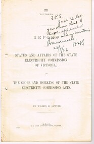
Document - Report, Willits H. Sawyer, "Report on the Status and Affairs of the State Electricity Commission of Victoria", 1926
... Street Railway companies, the Railway Engineering Department... Engineering Department of General Electric and the firm Ford Bacon ...Report - 32 pages centre stapled, printed on foolscap paper, has an index (see image i2), report of the Royal Commissioner Sawyer titled "Report on the Status and Affairs of the State Electricity Commission of Victoria and the scope and working of the State Electricity Commission Acts". Looks at the financial situation of the Commission, its management, equipment, power supply systems, Newport, technical issues, hydro power stations, Yallourn, problems with brown coal, use of Richmond Power station Signed by author on rear page. Note: At the time of cataloguing very little found on Mr. W. Sawyer - see reference in Trove for meeting with Sir John Monash - http://trove.nla.gov.au/newspaper/article/3737172/446386 and International Electrical Engineers - http://ieeexplore.ieee.org/stamp/stamp.jsp?arnumber=5217646, that he died 1/3/1966, age 93 - had been associated with Electric Street Railway companies, the Railway Engineering Department of General Electric and the firm Ford Bacon and Davis in New York City. For scan of full document see htd2104i3.pdf - downloaded from the Parliamentary web site - 29/7/2018.In the top right hand sector "J.P.S. just to let you know that I have appreciated your many courtesies and kindnesses HHS - 28/5/26". On rear page, has been signed by Willits H. Sawyer.trams, tramways, secv, power supply, royal commission, newport power station, richmond power station -
 Federation University Historical Collection
Document - Document - Presentation, VIOSH: Social History; Introduction to Sociology of Work and Technology Presentation, post 1997
... -ordinator), Mr Tom Norwood (Head of the Mechanical Engineering...-ordinator), Mr Tom Norwood (Head of the Mechanical Engineering ...Victorian Institute of Occupational Safety and Health (VIOSH) Australia is the Asia-Pacific centre for teaching and research in occupational health and safety (OHS) and is known as one of Australia's leaders on the field. VIOSH has a global reputation for its innovative approach within the field of OHS management. VIOSH had its first intake of students in 1979. At that time the Institution was known as the Ballarat College of Advanced Education. In 1990 it became known as Ballarat University College, then in 1994 as University of Ballarat. It was 2014 that it became Federation University. VIOSH Australia students are safety managers, senior advisors and experienced OHS professionals. They come from all over Australia and industry. Students are taught active research and enquiry; rather than textbook learning and a one-size fits all approach. VIOSH accepts people into the Graduate Diploma of Occupational Hazard Management who have no undergraduate degree - on the basis of extensive work experience and knowledge. Brief outline of the history of the development of VIOSH, and those responsible. They were Derek Viner (the initial Course Co-ordinator), Mr Tom Norwood (Head of the Mechanical Engineering Department), Mr Eric Wigglesworth (Chairman of the Education Committee of the Safety Institute of Australia) and Mr Zig Plavina (Technical Officer in the School of Engineering and Secretary of the Campus Safety Committee). Dr Dennis Else from the University of Aston, Birmingham arrived to establish the Victorian Institute of Occupational Safety and Health within the Engineering division of the University. Following the introductory speech, the talk gave information on the development, problems and theory of designing safe workplaces.One A4 page typed.viosh, victorian institute of occupational safety and health, social history, sociology, derek viner, course co-ordinator, tom norwood, head of mechanical engineering, eric wigglesworth, chairman, education committee of the safety institute of australia, zig plavina, technical officer, school of engineering, campus safety committee, university of aston, dennis else -
 Kew Historical Society Inc
Plan, Melbourne & Metropolitan Board of Works. Borough of Kew Detail Plan No.1579, 1904
... working in the Engineering Department of the Borough and later... by the contractor, but more likely by officers working in the Engineering ...The Melbourne and Metropolitan Board of Works (MMBW) plans were produced from the 1890s to the 1950s. They were crucial to the design and development of Melbourne's sewerage and drainage system. The plans, at a scale of 40 feet to 1 inch (1:480), provide a detailed historical record of Melbourne streetscapes and environmental features. Each plan covers one or two street blocks (roughly six streets), showing details of buildings, including garden layouts and ownership boundaries, and features such as laneways, drains, bridges, parks, municipal boundaries and other prominent landmarks as they existed at the time each plan was produced. (Source: State Library of Victoria). This plan forms part of a large group of MMBW plans and maps that was donated to the Society by the Mr Poulter, City Engineer of the City of Kew in 1989. Within this collection, thirty-five hand-coloured plans, backed with linen, are of statewide significance as they include annotations that provide details of construction materials used in buildings in the first decade of the 20th century as well as additional information about land ownership and usage. The copies in the Public Record Office Victoria and the State Library of Victoria are monochrome versions which do not denote building materials so that the maps in this collection are invaluable and unique tools for researchers and heritage consultants. A number of the plans are not held in the collection of the State Library of Victoria so they have the additional attribute of rarity.Original survey plan, issued by the MMBW to a contractor with responsibility for constructing sewers in the area identified on the plan within the Borough of Kew. The plan was at some stage hand-coloured, possibly by the contractor, but more likely by officers working in the Engineering Department of the Borough and later Town, then City of Kew. The hand-coloured sections of buildings on the plan were used to denote masonry or brick constructions (pink), weatherboard constructions (yellow), and public buildings (grey). While MMBW Plan No.1579 does not include many buildings, those that it does show are significant to Kew’s history. These include the ‘Kew [Railway] Station’ in Denmark Street and the ‘Recreation Hall’ and rear courts off Wellington Street. The plan shows the outline of the Recreation Hall, constructed in 1880, at the rear of which is listed a bowling green, two tennis courts, a ‘skittle alley’ and a pavilion. When the Hall was first built, the Kew Cricket Club occupied an adjacent ground, however in 1885 this was acquired by the State Government as the future location of the Kew Railway Station. The Plan also shows a single oval at Xavier College. This oval was completed in 1883. One of the current ovals conforms to this oval’s original shape and position in the school grounds.melbourne and metropolitan board of works, detail plans, maps - borough of kew, mmbw 1579, cartography -
 Kew Historical Society Inc
Plan, Melbourne & Metropolitan Board of Works / Borough of Kew, Detail Plan No.1593, 1905
... working in the Engineering Department of the Borough and later... working in the Engineering Department of the Borough and later ...The Melbourne and Metropolitan Board of Works (MMBW) plans were produced from the 1890s to the 1950s. They were crucial to the design and development of Melbourne's sewerage and drainage system. The plans, at a scale of 40 feet to 1 inch (1:480), provide a detailed historical record of Melbourne streetscapes and environmental features. Each plan covers one or two street blocks (roughly six streets), showing details of buildings, including garden layouts and ownership boundaries, and features such as laneways, drains, bridges, parks, municipal boundaries and other prominent landmarks as they existed at the time each plan was produced. (Source: State Library of Victoria)This plan forms part of a large group of MMBW plans and maps that was donated to the Society by the Mr Poulter, City Engineer of the City of Kew in 1989. Within this collection, thirty-five hand-coloured plans, backed with linen, are of statewide significance as they include annotations that provide details of construction materials used in buildings in the first decade of the 20th century as well as additional information about land ownership and usage. The copies in the Public Record Office Victoria and the State Library of Victoria are monochrome versions which do not denote building materials so that the maps in this collection are invaluable and unique tools for researchers and heritage consultants. A number of the plans are not held in the collection of the State Library of Victoria so they have the additional attribute of rarity.Original survey plan, issued by the MMBW to a contractor with responsibility for constructing sewers in the area identified on the plan within the Borough of Kew. The plan was at some stage hand-coloured, possibly by the contractor, but more likely by officers working in the Engineering Department of the Borough and later Town, then City of Kew. The hand-coloured sections of buildings on the plan were used to denote masonry or brick constructions (pink), weatherboard constructions (yellow), and public buildings (grey). The laborious task of hand-tinting these Board of Works plans was not without hazards as is evidenced by Plan No. 1593. On the Plan, the original colourist spilt black and green ink, partially obscuring some parts. The most obvious casualty is ‘Clifton’ located on the corner of Cotham Road and Park Street [now Adeney Avenue]. Included in this Plan, and outlined in pink is that part of the section that the contracting engineer was tasked with completing. This included sewering on both sides of this part of Cotham Road, but excluded properties such as ‘Glendonald’ and ‘Monnington’. This area was to undergo a series of subdivisions including the ‘Clifton Estate’, which created housing lots on Adeney Avenue and Florence Avenue in 1916. The most notable occupant of Clifton was William Adeney [died 1893], a pioneer of Camperdown, after which Park Street was later renamed.melbourne and metropolitan board of works, detail plans, survey plans - borough of kew, mmbw 1593, cartography