Showing 179 items
matching east orchard
-
 Ringwood and District Historical Society
Flyer, Stillwell & Stephens Pty. Ltd, Brochure - Multiple Properties for Public Auction at Box Hill, Ringwood, Wonga Park and Clarinda - 28th November, 1934
Seven-page brochure advertising Mortgagees' Realising Sale by Public Auction on Wednesday, 28th November, 1934 for properties at Box Hill, Ringwood, Wonga Park, and Clarinda (via Oakleigh), including photographs, property descriptions, and terms of sale.Auction Commencing at 2.15 p.m. in the Orient Line Auction Rooms, 352 Collins Street, Melbourne. Solicitors: Messrs. Madden, Butler, Elder & Graham, 406 Collins Street, Melbourne. (Agents) H.P. Knight & Co. Property Salesmen and Subidivisional Experts, 315 Collins Street, Melbourne, 'Phones: Central 10615, 10616. Attractive Residential, Orchard, and Market Garden Properties, and Public Hall and School Rooms. 1. Wonga Park via Ringwood - "Holme Bush" off Warrandyte Road, Part of Lots 14 and 15, Ringwood Orchard Estate, approximatgely three miles (north) of Ringwood Railway Station - 64 Acres. 2. 17 Bishop Street, Box Hill - timber residence. 3. Greenwood Avenue, Ringwood - On East Side, 150 feet 3 inches South of Bedford Road - timber attic residence. 4. Ringwood - Wantirna Road, South-east corner of Canterbury Road - Orchard Property of approx. 11-1/2 Acres. 5. Box Hill - Whitehorse Road, South-east corner of Linsley Street - Timber building utilised as a Public Hall and Private School. 6. Clarinda vic Oakleigh, Talbot Crescent, off Centre Road - Home on 10 acres of land. -
 Ringwood and District Historical Society
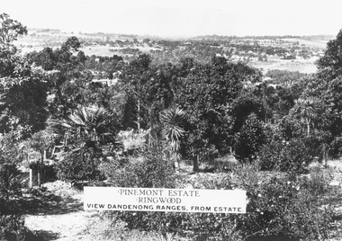
Photograph, Two images of view from Pinemont Estate, Loughnans Hill, looking east, c1930
Black and white photograph of view. Trees and bushes in foreground, orchards and mountains towards background. (2 copies)Typed on photograph, "Pinemont Estate, Ringwood. View Dandenong Ranges, from estate". Typed below photograph, "View from Loughnans Hill, looking east, c1930. Club Hotel can just be seen top right corner". -
 Ringwood and District Historical Society
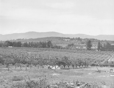
Photograph, View from Wonga Rd. over Mullum Rd. (centre) and beyond - 1946. Orchards: French, Vergers
"View from Wonga Rd. looking east towards Mullum Rd. 1946" and "Looking from Wonga Rd. over Mullum Rd. (centre) and beyond. Orchards: French, Vergers". -
 Ringwood and District Historical Society
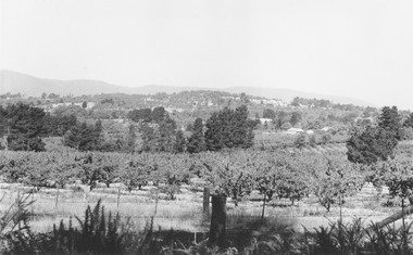
Photograph, Mr. F. Goulding's orchard. Looking across to Ringwood East from Wonga Rd. 1960
Typed below photograph, "Mr. F. Goulding's orchard. Looking across to Ringwood East from Wonga Rd. 1960". -
 Ringwood and District Historical Society
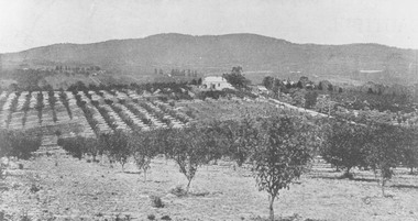
Photograph, View from Canterbury Road/Balfour Avenue area overlooking Martell's orchard, Heathmont, 1929
Black and white photograph of orchard. House in middle range, mountains in background. Photograph appears to be reproduced from subdivisional brochure. Note inserted in sleeve reads, "It has been pointed out that the mountains are to the east and the view is looking south. This therefore is not a 'straight' photograph. House still exists in Eden Avenue at October, 1996".(3 copies).Typed below photograph, "Panoramic view taken on the estate". "View overlooking Martell's orchard, Heathmont, 1929". Taken from corner Canterbury Rd. and Balfour Ave. looking south. Dandenong Creek just beyond house. Washusen Rd. on right". Written on back of one of the copies, "Heathmont Station Estate 1922". "Station Street, Lisgoold St. Canterbury Rd. Vivienne Cres. Balfour Ave." -
 Ringwood and District Historical Society
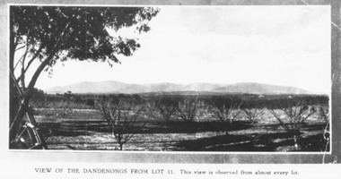
Photograph, Mullers orchard, Heathmont. Looking east from cnr. Canterbury and Dickasons Rds. "Charm View Estate" - 1926
... Mullers orchard, Heathmont. Looking east from cnr... and Dickasons Rds. Looking east - 1926". Mullers orchard, Heathmont ...Printed below photograph, "View of the Dandenongs from Lot 11. This view is observed from almost every lot". Written on back of a photograph, "Photo taken from sub. div. plan land sales. Charm View Estate, Heathmont, 1926?" Another copy reads, "Mullers orchard, Heathmont. Taken from cnr. Canterbury and Dickasons Rds. Looking east - 1926". -
 Marysville & District Historical Society
Photograph (Item) - Black and white photograph, Fernshaw, c1900
An early black and white photograph taken at Fernshaw.An early black and white photograph taken at Fernshaw. Fernshaw was a rural township 63 km north-east of Melbourne and 10 km north-east of Healesville. Situated on the Watts River, near where a log had fallen making a convenient crossing, Fernshaw was settled in the 1860s. It provided good country for orchards and berry growing. The location was at the foot of Blacks Spur, with Mounts Juliet and Mondah rising on either side, providing spectacular scenery. There were nearby fern gullies giving rise to the name – ‘shaw’ is old English for thicket or wood. By 1875 Fernshaw had a post office (1865), two hotels, a school (1871) and stores. It was famed for its beauty, attracting tourists. In 1886 the Melbourne and Metropolitan Board of Works began work on the Watts River water catchment scheme – later to become Maroondah – and the Board obtained approval for the catchment country to be reserved and kept free of settlement. This required the removal of the Fernshaw township, which was completed by about 1890. The area was described in the 1903 Australian handbook:ARMSTRONG COLLECTION 42 STATION STREET/ SANDRINGHAM 3191/ TEL. (03) 9521 5442/ IAN M.L. ARMSTRONG OAMfernshaw, healesville, watts river, orchard, berry orchard, blacks spur, black spur, mount juliet, mount mondah, maroondah dam, victoria -
 Ringwood and District Historical Society
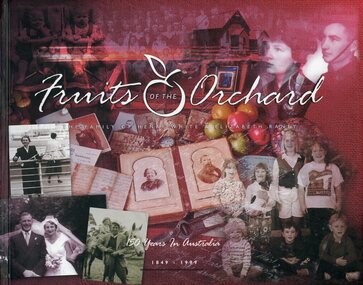
Book, White Family Tree Committee, Fruits of The Orchard - The Family of Henry White & Elizabeth Raney, 1999
560-page hardcover book subtitled 150 Years In Australia 1849-1999. The book traces the lives and descendants of Henry and Elizabeth White from the time leading up to their marriage in Melbourne in 1852 and subsequent move to the Doncaster district where they established a farm and orchard known as Deep Creek Farm in Doncaster East. Compiled & edited by the White Family Tree Committee 1993-1999 - Dorothy Aumann (Hill), Barry Fischer, Betty Geddes(Ford), Jean Gillinders (Dempster), Alice Latimer (White), Bill Latimer, Robert Latimer, Raney McAlpin (Mackinlay). -
 Ringwood and District Historical Society
Map - State Aerial Survey, Dandenong Ranges Area, Parts of Parishes of Nunawading, Warrandyte and Ringwood - 1956
... Orchards and Ringwood East compiled by Dept of Lands and Survey... Orchards and Ringwood East compiled by Dept of Lands and Survey ...Map of Ringwood North and parts of Mitcham, Donvale, Park Orchards and Ringwood East compiled by Dept of Lands and Survey, July 1956, from aerial photographs and Cadastral Survey information. Sheet 1, Ringwood A2D or 849 A2D Zone 7. Scale: 4 chains to 1 inch. Contour interval 20 feet. -
 City of Moorabbin Historical Society (Operating the Box Cottage Museum)
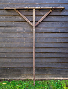
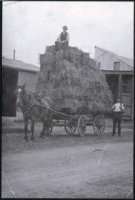
Farm Equipment, Rake, large Hay c1900, c1900
A hay rake is an agricultural rake used to collect cut hay or straw into windrows for later collection (e.g. by a baler or a loader wagon). It is also designed to fluff up the hay and turn it over so that it may dry. The next day it is spread again, so that the hay dries more quickly. Early settlers established productive market gardens, poultry,. pig and dairy farms , orchards and vineyards on the land in the 'Henry Dendy Special Survey Brighton 1841' - now Ormond, Bentleigh, East Bentleigh, Brighton, This hay rake is typical of the type used by early settlers in Moorabbin Shire c1900Large wooden Hay rake , hand made c1900farm equipment, hay rakes, hammers, early settlers, market gardeners, blacksmiths, tools, building equipment, moorabbin shire, bentleigh, mckinnon, highett, cheltenham,ormond -
 City of Moorabbin Historical Society (Operating the Box Cottage Museum)
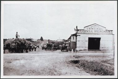
Photograph - Photograph, Black & White Mrs J.L.Smith & Butcher, 1915
The Butcher Mr Bill Ellin delivering meat to Mrs J.L.Smith in front of the house Law Muir Den 510 Centre Rd Bentleigh c 1915. Groceries, Ice, Milk, Bread, Eggs, Poultry were delivered to housewives by the traders in horse drawn carts, Also Hawkers and Pedlars plied their wares by visiting the cottages. John Logan Smith 1860-1932 , the son of Irish immigrants James and Marianne Smith was born at their home near the 'Toll Gates' on Point Nepean Road and Dendy Street. East Brighton. At that time the area had many orchards that were later replaced by market gardens. J.L.Smith at first rented a cottage 'Law Muir Den' & Shed from Mr Box and commenced business as a wood merchant - sawing logs into shorter pieces using one horse to power the saw. He purchased the property, added to the buildings , began trading in fuel and fodder as well and installed a chaff cutting mill powered by 10hp steam engine. The business prospered 1909 following the death of Tommy Bent, J/L Smith was nominated for Councillor of the Shire of Moorabbin. WW1 1914 - 18 both John and Mary Ann supported local War Relief Auxiliaries and their son Vic served as a Signaler in AIF. As Motor transport was increasing 1926 J L Smith built a small Garage on the opposite corner (Woolworths Supermarket 2005) , employed a good mechanic ( Reg Hunt ) and developed another successful business. The Grain Store was managed by family until 1930. In 1932 JL Smith assisted a man whose car had broken down, pushing it to the garage and sadly suffered a heart attack and died. He is buried in Cheltenham Cemetery. J.L.Smith was an early settler in East Brighton now Bentleigh and established successful Wood cutting, Grain & Chaff cutting and Motor garage businesses in Centre Road . He was elected Councillor of the Shire of Moorabbin and, with Mary Ann, his family were involved with local Church, Red Cross, and other community organizations.A Black and white photograph c 1915 showing the Butcher delivering meat to Mrs J.L Smith Bentleighsmith j l, smith mary ann, stanley helen, smith vic, smith harry redvers, chaff cutter, horse drawn carts, toll gates brighton, motor cars 1900, steam engines, early settlers, bentleigh, parish of moorabbin, city of moorabbin, county of bourke, moorabbin roads board, shire of moorabbin, henry dendy's special survey 1841, bent thomas, charman s, highett william, ormond francis, market gardeners, vineyards, orchards, william ellin, butcher -
 City of Moorabbin Historical Society (Operating the Box Cottage Museum)
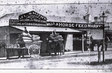
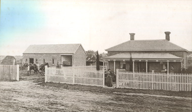
Photograph, Black & White J. L. Smith Hay & Grain Store Bentleigh c1910, c1910
John Logan Smith 1860-1932 , the son of Irish immigrants James and Marianne Smith was born at their home near the 'Toll Gates' on Point Nepean Road and Dendy Street. East Brighton. At that time the area had many orchards that were later replaced by market gardens. J.L.Smith at first rented a cottage 'Law Muir Den' & Shed from Mr Box and commenced business as a wood merchant - sawing logs into shorter pieces using one horse to power the saw. He purchased the property, added to the buildings , began trading in fuel and fodder as well and installed a chaff cutting mill powered by 10hp steam engine. The business prospered 1909 following the death of Tommy Bent, J/L Smith was nominated for Councillor of the Shire of Moorabbin. WW1 1914 - 18 both John and Mary Ann supported local War Relief Auxiliaries and their son Vic served as a Signaler in AIF. As Motor transport was increasing 1926 J L Smith built a small Garage on the opposite corner (Woolworths Supermarket 2005) , employed a good mechanic ( Reg Hunt ) and developed another successful business. The Grain Store was managed by family until 1930. In 1932 JL Smith assisted a man whose car had broken down, pushing it to the garage and sadly suffered a heart attack and died. He is buried in Cheltenham Cemetery. J.L.Smith was an early settler in East Brighton now Bentleigh and established successful Wood cutting, Grain & Chaff cutting and Motor garage businesses in Centre Road . He was elected Councillor of the Shire of Moorabbin and, with Mary Ann, his family were involved with local Church, Red Cross, and other community organizations.Black & white photograph of the Hay & Grain Store of John Logan Smith 1860-1932 on the corner of Jasper Rd and Centre Rd Bentleigh ( East Brighton) c1910. A Horse drawn cart loaded with hay and another outside the first building used by J L Smith -
 City of Moorabbin Historical Society (Operating the Box Cottage Museum)
Photograph, Black & White, J.L.Smith Hay & Grain Store c1916 Bentleigh, 1916
John Logan Smith 1860-1932 , the son of Irish immigrants James and Marianne Smith was born at their home near the 'Toll Gates' on Point Nepean Road and Dendy Street. East Brighton. At that time the area had many orchards that were later replaced by market gardens. J.L.Smith at first rented a cottage 'Law Muir Den' & Shed from Mr Box and commenced business as a wood merchant - sawing logs into shorter pieces using one horse to power the saw. He purchased the property, added to the buildings , began trading in fuel and fodder as well and installed a chaff cutting mill powered by 10hp steam engine. The business prospered 1909 following the death of Tommy Bent, J/L Smith was nominated for Councillor of the Shire of Moorabbin. WW1 1914 - 18 both John and Mary Ann supported local War Relief Auxiliaries and their son Vic served as a Signaler in AIF. As Motor transport was increasing 1926 J L Smith built a small Garage on the opposite corner (Woolworths Supermarket 2005) , employed a good mechanic ( Reg Hunt ) and developed another successful business. The Grain Store was managed by family until 1930. In 1932 JL Smith assisted a man whose car had broken down, pushing it to the garage and sadly suffered a heart attack and died. He is buried in Cheltenham Cemetery J.L.Smith was an early settler in East Brighton now Bentleigh and established successful Wood cutting, Grain & Chaff cutting and Motor garage businesses in Centre Road . He was elected Councillor of the Shire of Moorabbin and, with Mary Ann, his family were involved with local Church, Red Cross, and other community organizations.Black & White photograph of J L Smith Hay & Grain Store and Crushing Mill Jasper Rd / Centre Rd Bentleigh 1916. A veranda has been added to the store, new signage attached and a Gas light and hitching post are in foreground. 3 Horse drawn carts loaded with grain bags and drivers sitting on top of loadV. Smithgas street light, hitching posts, smith vic, photography, smith j l; smith mary ann, stanley helen, smith vic, smith harry redvers, chaff cutter, horse drawn carts, toll gates brighton, motor cars 1900, steam engines, early settlers, bentleigh, parish of moorabbin, city of moorabbin, county of bourke, moorabbin roads board, shire of moorabbin, henry dendy's special survey 1841, were j.b.; bent thomas, o'shannassy john, king richard, charman s, highett william, ormond francis, maynard dennis, market gardeners, vineyards, orchards -
 City of Moorabbin Historical Society (Operating the Box Cottage Museum)
Photographs, x 2 ,Black & White, F Smith Horse drawn cart loaded, Baled Straw, Grain, c1920
John Logan Smith 1860-1932 , the son of Irish immigrants James and Marianne Smith was born at their home near the 'Toll Gates' on Point Nepean Road and Dendy Street. East Brighton. At that time the area had many orchards that were later replaced by market gardens. J.L.Smith at first rented a cottage 'Law Muir Den' & Shed from Mr Box and commenced business as a wood merchant - sawing logs into shorter pieces using one horse to power the saw. He purchased the property, added to the buildings , began trading in fuel and fodder as well and installed a chaff cutting mill powered by 10hp steam engine. The business prospered 1909 following the death of Tommy Bent, J/L Smith was nominated for Councillor of the Shire of Moorabbin. WW1 1914 - 18 both John and Mary Ann supported local War Relief Auxiliaries and their son Vic served as a Signaler in AIF. As Motor transport was increasing 1926 J L Smith built a small Garage on the opposite corner (Woolworths Supermarket 2005) , employed a good mechanic ( Reg Hunt ) and developed another successful business. The Grain Store was managed by family until 1930. In 1932 J L Smith assisted a man whose car had broken down, pushing it to the garage and sadly suffered a heart attack and died. He is buried in Cheltenham Cemetery. J.L.Smith was an early settler in East Brighton now Bentleigh and established successful Wood cutting, Grain & Chaff cutting and Motor garage businesses in Centre Road . He was elected Councillor of the Shire of Moorabbin and, with Mary Ann, his family were involved with local Church, Red Cross, and other community organizations.2 x Black & White photographs showing horse drawn carts loaded with (a) Hay and (b) bags of grain outside J.L.Smith Grain & Chaff Store Centre Rd Bentleigh c1920smith frank, smith arch, smith tom, smith j l; smith mary ann, stanley helen, smith vic, smith harry redvers, chaff cutter, horse drawn carts, toll gates brighton, motor cars 1900, steam engines, early settlers, bentleigh, parish of moorabbin, city of moorabbin, county of bourke, moorabbin roads board, shire of moorabbin, henry dendy's special survey 1841, were j.b.; bent thomas, o'shannassy john, king richard, charman s, highett william, ormond francis, maynard dennis, market gardeners, vineyards, orchards -
 City of Moorabbin Historical Society (Operating the Box Cottage Museum)
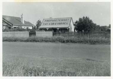
Photograph, Black & White, J.Redmore "God Cottage' Bentleigh c1890, c1900
1890 - 1950 This little cottage was located near the corner of Centre Road and Jasper Road East Brighton ( now Bentleigh) between where the Bentleigh RSL and Woolworths Supermarket now stand. Rev.B.Redmore, and his wife, were early members of the Salvation Army Corps, and they went to unusual lengths to proclaim their faith. Texts were hung along the veranda to catch the attention of passers-by and on the iron roof was painted a large sign ' PREPARE TO MEET THY GOD O' ISRAEL' ( The apostrophe is not a misprint.) The Cottage became known locally as The "God Cottage" and was demolished c1950 ( H.Stanley 2005)The 'God Cottage ' with its Biblical texts and large roof sign was an unique feature in East Brighton ( Bentleigh) 1890 - 1950 Black & White photograph showing a small cottage with a large sign painted on the roofBack Handwritten informationredmore reverend b, salvation army, smith j l; smith mary ann, stanley helen, smith vic, chaff cutter, horse drawn carts, toll gates brighton, motor cars 1900, steam engines, early settlers, bentleigh, mckinnon, parish of moorabbin, city of moorabbin, county of bourke, moorabbin roads board, shire of moorabbin, henry dendy's special survey 1841, were j.b.; bent thomas, o'shannassy john, king richard, charman stephen, highett william, ormond francis, maynard dennis, market gardeners, vineyards, orchards -
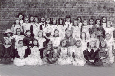 City of Moorabbin Historical Society (Operating the Box Cottage Museum)
Photograph - Black & White East Bentleigh State School No 2083 c1900
Early settlers established market gardens, farms and business in the East Brighton ( East Bentleigh) area of Henry Dendy's Special Survey 1841 Brighton. The small communities established Churches and Schools. The Church of England opened St Stephen's Common School c 1850 in Tucker Road with 26 pupils. When the Government School opened 1878 the pupils were transferred to the new Centre Road building and it served the developing East Bentleigh Community until 1990. East Bentleigh State School no. 2083, Centre Road 1878 was closed c1990 due to the dwindling number of pupils enrolling following development of Valkstone SS East Bentleigh, Ormond East SS ( now McKinnon SS) and Tucker Road SS East Bentleigh Names of Pupils inscribed on back of original photograph show the children of the early settler families in Moorabbin Shire Back Row -Bessie long, Ruby Marriott, Irene Peterson, Jessie Gebuer, Grace Reid, Ella Marriott, Daisy Arnold, Lucy Hosking 2nd standing - Edie Roberts, Daisy Marriott, Elsie Strack, Ida Gouruly, Ephanie Bruce, Emma Thompson, Evelyn Marriott, Sarah Jackson, Lola G. 3rd kneeling - Lily Moore, Lizzie Sharman, Mag. Scotland, Em Ray, Elsie Claydon, Lily Marriott, ?? Day, ,Bessie Brewster, Eva Lindberg Front- Florrie D......ieson, Florrie ...i....ade, Ruth Goodrich, Lily Boles, Ettie Arnold, Bessie Marriott, Amie Jackson, Eileen Hosking The Government School opened 1878 in the new Centre Road building near Tucker Road, and it served the developing East Bentleigh Community until 1990. East Bentleigh State School no. 2083, Centre Road 1878 was closed c1990 due to dwindling number of pupils following development of Valkstone SS East Bentleigh, Ormond East SS ( now McKinnon SS) and Tucker Road SS East Bentleigh all situated along or near Tucker Road. Black & White photograph, reproduced c2005., of girl pupils at East Bentleigh State School 2083 c 1900east bentleigh state school no.2083c1900, marriott john, box jessie, pederson vic, long bessie, wong george, shephard hilda, mcneil annie, smith j l; smith mary ann, stanley helen, smith vic, smith harry redvers, chaff cutter, horse drawn carts, toll gates brighton, motor cars 1900, steam engines, early settlers, bentleigh, mckinnon, parish of moorabbin, city of moorabbin, county of bourke, moorabbin roads board, shire of moorabbin, henry dendy's special survey 1841, were j.b.; bent thomas, o'shannassy john, king richard, charman stephen, highett william, ormond francis, maynard dennis, market gardeners, vineyards, orchards -
 City of Moorabbin Historical Society (Operating the Box Cottage Museum)
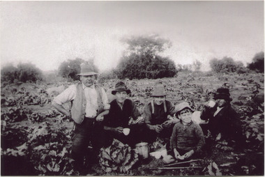
Photograph, Black & White, V Peterson E Boundary Rd E Bentleigh market garden c1925, Original c1925
The Peterson family were early settlers in Moorabbin Shire and established a market garden in East Boundary Road East Bentleigh. Vic Peterson - waistcoat, with Dick Marriott seated - ( brother in -law ), 2 unknown men and 7year old Geoff Peterson - Poliomyelitis as a baby- sitting in front with his walking sticks. The crop is cabbages that would be harvested and sent to the Melbourne markets.The early settlers like the Petersons and Marriotts, in the Parish of Moorabbin County of Bourke after Henry Dendy's Special Survey Brighton 1841, established market gardens, fruit & flower gardens, poultry & dairy farms, vineyards as well as shop businesses, blacksmiths, chemists, nursing homes and schools & Churches.Black & White photograph of Vic Peterson and 3 men & boy on his market garden in East Boundary Road East Bentleigh c1925 re-digitised 2005back ; handwritten information unsignedwagons, vulcan trucks, draught horses,, peterson vic, marriott dick, cabbage crops, vegetable crops, poliomyelitis epidemics 20thc , elster creek, plateways moorabbin shire, smith j l; smith mary ann, stanley helen, smith vic, smith harry redvers, chaff cutter, horse drawn carts, toll gates brighton, motor cars 1900, steam engines, early settlers, bentleigh, mckinnon, parish of moorabbin, city of moorabbin, county of bourke, moorabbin roads board, shire of moorabbin, henry dendy's special survey 1841, were j.b.; bent thomas, o'shannassy john, king richard, charman stephen, highett william, ormond francis, maynard dennis, market gardeners, vineyards, orchards -
 City of Moorabbin Historical Society (Operating the Box Cottage Museum)
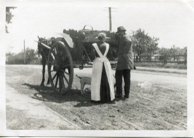
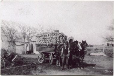
Photograph, Black & White, V Peterson East Boundary Rd East Bentleigh loaded wagon c1900, original c1900
The Peterson family were early settlers in Moorabbin Shire and established a market garden in East Boundary Road East Bentleigh. Vic Peterson and family loaded the crop - cabbages - onto the horse drawn wagon and set off to the Melbourne market using the Plateways that ran along Centre Road and Nepean Highway. The early settlers like the Petersons , in the Parish of Moorabbin County of Bourke after Henry Dendy's Special Survey Brighton 1841, established market gardens, fruit & flower gardens, poultry & dairy farms, vineyards as well as shop businesses, blacksmiths, chemists, nursing homes and schools & Churches.Black & White photograph showing Vic Peterson beside the horse drawn wagon loaded with 35dozen ( 12x 35) cabbages setting off to market c 1900 Original re-digitised by H Stanley 2005Back Hand written informationwagons, vulcan trucks, draught horses,, peterson vic, marriott dick, cabbage crops, vegetable crops, poliomyelitis epidemics 20thc , elster creek, plateways moorabbin shire, smith j l; smith mary ann, stanley helen, smith vic, smith harry redvers, chaff cutter, horse drawn carts, toll gates brighton, motor cars 1900, steam engines, early settlers, bentleigh, mckinnon, parish of moorabbin, city of moorabbin, county of bourke, moorabbin roads board, shire of moorabbin, henry dendy's special survey 1841, were j.b.; bent thomas, o'shannassy john, king richard, charman stephen, highett william, ormond francis, maynard dennis, market gardeners, vineyards, orchards -
 City of Moorabbin Historical Society (Operating the Box Cottage Museum)
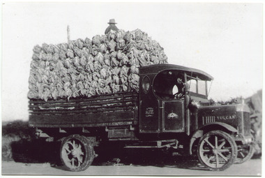
Photograph, Black & White, V Peterson, loaded Vulcan Truck 1929, c1929
The Peterson family were early settlers in Moorabbin Shire and established a market garden in East Boundary Road East Bentleigh. Horse drawn wagons traveled along Plateways to take their crops to the Melbourne Markets . With the advent of the motorcar the market gardeners gradually purchased trucks to transport their crops. Roads were being surfaced but ruts and flooding caused upsets and bogging of these trucks. The journey was quicker but unlike the Horses, these trucks could not drive themselves back to the farm.The early settlers like the Petersons and Marriotts, in the Parish of Moorabbin County of Bourke after Henry Dendy's Special Survey Brighton 1841, established market gardens, fruit & flower gardens, poultry & dairy farms, vineyards as well as shop businesses, blacksmiths, chemists, nursing homes and schools & Churches.Black & White photograph of a Vulcan truck driven by Vic Peterson, loaded with Cauliflowers from his market garden in East boundary Road East Bentleigh c 1929.Back Handwritten information unsgnedwagons, vulcan trucks, draught horses,, peterson vic, marriott dick, cauliflower crops, vegetable crops, poliomyelitis epidemics 20thc , elster creek, plateways moorabbin shire, smith j l; smith mary ann, stanley helen, smith vic chaff cutter, horse drawn carts, toll gates brighton, motor cars 1900, steam engines, early settlers, bentleigh, mckinnon, parish of moorabbin, city of moorabbin, county of bourke, moorabbin roads board, shire of moorabbin, henry dendy's special survey 1841, were j.b.; bent thomas, o'shannassy john, king richard, charman stephen, highett william, ormond francis, maynard dennis, market gardeners, vineyards, orchards -
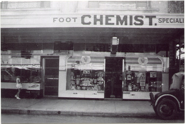 City of Moorabbin Historical Society (Operating the Box Cottage Museum)
Photograph, Black & White, Mr Moore's 1st Chemist Shop Centre Road, Bentleigh c1930, c1930
Early settlers in the Parish of Moorabbin, County of Bourke, established market gardens and farms in the area of Henry Dendy's Special Survey 1841 Brighton. Small communities grew near Churches & Schools and shops and businesses were established. Following the opening of the Railway line from Caulfield to Mordialloc 1881 the shops and business moved from the Tucker Road /Centre Road ( East Brighton ) East Bentleigh area to be close to the transport. Shops, businesses and housing developed along Centre Road between Thomas Street and Jasper Road. Mr Arthur Moore established his 1st shop in 395 Centre Road c1930 and later moved along the road to a site next to Coles Variety Store.Following the opening of the Railway line from Caulfield to Mordialloc 1881 the shops and business moved from the Tucker Road /Centre Road East Bentleigh area to be close to the transport. Shops, businesses and housing developed along Centre Road between Thomas Street and Jasper Road. Mr Moore established his 1st shop in 395 Centre Road c1930 and later moved along the road to a site next to Coles Variety Store.Black & White photograph of Mr Arthur Moore's 1st Chemist Shop, 384 Centre Road Bentleigh c 1930 back Handwritten information unsignedbentleigh shopping centre c1930, east brighton, railway line caulfield -mordialloc 1881, chemists, pharmacy, moore's moorabbin shire, smith j l, smith mary ann, stanley helen, smith vic, smith harry redvers, chaff cutter, horse drawn carts, toll gates brighton, motor cars 1900, steam engines, early settlers, bentleigh, mckinnon, parish of moorabbin, city of moorabbin, county of bourke, moorabbin roads board, shire of moorabbin, henry dendy's special survey 1841, were j.b., bent thomas, o'shannassy john, king richard, charman stephen, highett william, ormond francis, maynard dennis, market gardeners, vineyards, orchards -
 City of Moorabbin Historical Society (Operating the Box Cottage Museum)
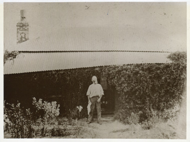
Photograph, Black & White, John Box 1841-1913 and Document re Will, a) c1900 b) 1928
John Box 1841 - 1913 was a member of the George Box family who migrated from Sussex England 1855 and established market gardens in Parish of Moorabbin, County of BourkeJohn Box was a pioneer settler 1855 in Moorabbin Shire, County of Bourke and established a market garden and raised his family.a)Black & White photograph of John Box standing at his home in North Road East Bentleigh c1900 b) Document - letter regarding the Estate of John Box 1928a) nil b) as printedbox george,b 1808, box john1841 - 1913, box william, box elizabeth smith j l; smith mary ann, stanley helen, smith vic, chaff cutter, horse drawn carts, early settlers, bentleigh, mckinnon, parish of moorabbin, city of moorabbin, county of bourke, moorabbin roads board, shire of moorabbin, henry dendy's special survey 1841, were j.b.; bent thomas, o'shannassy john, king richard, charman stephen, highett william, ormond francis, maynard dennis, market gardeners, vineyards, orchards -
 City of Moorabbin Historical Society (Operating the Box Cottage Museum)
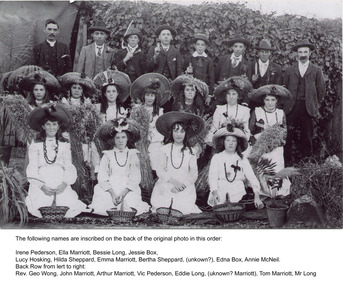
Photograph, Black & White,Methodist Youth 'Harvest Festival' East Bentleigh c1910, original c1910
Early settlers established market gardens, farms and business in the East Brighton ( East Bentleigh) area of Henry Dendy's Special Survey 1841 Brighton. The small communities established Churches and Schools. Stephen Charman, 1821-1906 a market gardener, donated land for the first Methodist Chapel, Cemetery and School in Charman Rd Cheltenham 1855. The East Bentleigh settlers built a Methodist Church in Tucker Road and established the Sunday School and Youth group which organised social and sporting events and picnics.Early settlers established market gardens, farms and business in the East Brighton ( East Bentleigh) area of Henry Dendy's Special Survey 1841 Brighton. The small communities established Churches and Schools. Black and White photograph showing the Bentleigh Methodist Youth Group on Harvest Thanksgiving Sunday c1910 in front of R.Smith's shed in Tucker Road East Bentleigh re-digitised by H.Stanley CMHS 2005Back Handwritten Names on Original photograph Front row Irene Pederson, Ella Marriott, Bessie Long, Jessie Box, Lucy Hosking, Middle row Hilda Sheppard, Emma Marriott, Bertha Sheppard, ? , Edna Box, Annie McNeil Back row Rev. George Wong, John Marriott, Arthur Marriott, Vic Pederson, Eddie Long, ? Marriott,, Tom Marriott, Mr Long methodist youth group bentleigh c1910, marriott emma, marriott ella, hosking lucy, marriott john, box jessie, pederson vic, long bessie, wong george, shephard hilda, mcneil annie, smith j l; smith mary ann, stanley helen, smith vic, smith harry redvers, chaff cutter, horse drawn carts, toll gates brighton, motor cars 1900, steam engines, early settlers, bentleigh, mckinnon, parish of moorabbin, city of moorabbin, county of bourke, moorabbin roads board, shire of moorabbin, henry dendy's special survey 1841, were j.b.; bent thomas, o'shannassy john, king richard, charman stephen, highett william, ormond francis, maynard dennis, market gardeners, vineyards, orchards -
 City of Moorabbin Historical Society (Operating the Box Cottage Museum)
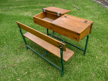
Education, 2 wooden 2 seat school desks c1950, c1950
Typical wooden school desks used c 1950 in Victoria Typical of school desks used by pupils in schools in Victoria c 19502 (two) wooden school desks with ink wells and lift up writing lids for 2 children A) Is on an iron frame with a bench seat b) is on an iron frame with 2 separate seats education, schools, early settlers, bentleigh, parish of moorabbin, city of moorabbin, county of bourke, moorabbin roads board, shire of moorabbin, henry dendy's special survey 1841, were j.b.; bent thomas, o'shannassy john, king richard, charman stephen, highett william, ormond francis, maynard dennis, market gardeners, vineyards, orchards, state schools victoria, marriott c, whelan k, cochrane a, east bentleigh state school 2083, -
 City of Moorabbin Historical Society (Operating the Box Cottage Museum)
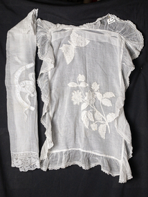
Haberdashery, pillow shams white voile,lace,needlework x 2 c1900, c1900
These 2 pillow shams in white voile,lace and with needlework were made by a woman of an early settler family in Moorabbin Shire c1900. Women made and mended clothes, haberdashery and drapery for their families as the market gardens and farms were established in Moorabbin, East Brighton, Cheltenham.These 2 pillow shams in white voile, lace and with needlework are examples of the dressmaking and needlework skills of the women of the early settler families in Moorabbin Shire c1900 2 Haberdashery, pillow shams in white voile,with lace edging , a) Is an envelope type with bone buttons and has a central needlework floral and butterfly design . b) is single layer with a central needlework ribbon design c1900clothing, brighton, moorabbin, pioneers, dressmaking, market gardeners, early settlers, craftwork , bentleigh, lacework, moorabbin shire, dairy farms, fruit orchards -
 City of Moorabbin Historical Society (Operating the Box Cottage Museum)
Photograph - 115 Jasper Road, Bentleigh, Allan / Grewer Estate, c. 1890's
115 Jasper Road, Bentleigh East was a market garden owned by James Allan. In 1880 the property was transferred to David Grewar (Gruar) who had married James' niece Mary Allan. In 1926 part of the land was subdivided and sold as residential blocks. The block with the house pictured remained in the family until 1969. The land now forms part of Our Lady of Sacred Heart College. The description of the land owned by David Kidd Grewer (also spelt Gruar) in 1885: Fourteen acres or thereabouts at the corner of Jasper Road and Patterson’s Road East Brighton being part of Crown Block of 5720 acres Parish of Moorabbin County of Bourke being land comprised in Certificate of Title Volume 1344 Folio 268692 on which is erected a 4 roomed brick house with 2 rooms of wood at the rear and stable and a 2 roomed weatherboard cottage valued as under: 14 acres of land less crops £629.0.0 4 roomed brick house £250.0.0 Other buildings £50.0.0 2 roomed weatherboard cottage £35.0.0 Early pioneer family of the City of Moorabbin.Black and White photo in picture framegrewar, market garden, moorabbin, bentleigh, jasper road, housing, pioneer, james allan, orchard -
 St Kilda Historical Society
Ephemera - Ticket, Picnic to Park Orchards, 1936
Ticket to picnic at Park Orchards on 21 December 1936, organised by the St Kilda Unemployed Organisation with the support of the St Kilda City Council, Mayor (Cr Alfred Levy), Archie Michaelis MLA, and 'other well-known gentlemen'. The ticket appears to have been perforated to allow vouchers, printed on the back (for bus, dinner, toys, stockings, ice cream and tea) to be separated and used. Park Orchards is a residential suburb 23km north east of Melbourne that was created in 1925 on land used for orchards when timber merchants Australis Sharp and John Taylor launched the Park Orchards Country Club estate. Buyers were not attracted to the estate, and for many years all that existed were a clubhouse and various sporting facilities. It gained popularity when demand for housing surged in the 1950s.Grey/green coloured card, printed in blue on both sides and with 5 evenly spaced lines of perforations across the width.st kilda unemployed organisation, st kilda council -
 Whitehorse Historical Society Inc.
Document, Motor Cycle Climb and mud bash|A Walk down memory lane|An early glimpse of Royton Street, 1994
... Burwood East Walford Family Orchards Cooinda Court Burwood East ...Hartwell Motor Cycle Club.Hartwell Motor Cycle Club. The East Burwood section of its run comprised Holland road, Burwood Road and Ely Road. It was very steep and muddy. Description of a walk along Burwood Road to Middleborough Road in 1929 - 30. History of Royton Street, East Burwood and its neighbourhood from the 1930's to the present.Hartwell Motor Cycle Club. motor cycles, hartwell motor cycle club, holland road, burwood east, eley road, burwood east, burwood east state school no 454, royton street, burwood east, walford family, orchards, cooinda court, burwood east, market gardens, east burwood methodist church, french, joseph a, black, roy, rescheck family, french, harry w, crow, ernie, mclean, leckie, newbigin family, royton street, burwood east, no 30, hele family, french family, carrol family, tally ho post office, walford family -
Whitehorse Historical Society Inc.
Book, Box Hill Reporter Cricket Association, 1994?
History of the Association, 1894 - 1994 with brief histories of some clubs.History of the Association, 1894 - 1994 with brief histories of some clubs.History of the Association, 1894 - 1994 with brief histories of some clubs.box hill reporter district cricket association, blackburn cricket club, blackburn north cricket club, blackburn south cricket club, box hill church of christ cricket club, box hill north cricket club, box hill pioneers cricket club, bulleen templestowe cricket club, burwood district cricket club, burwood heights uniting cricket club, coles myer cricket club, doncaster cricket club, east box hill cricket club, east burwood / bennettswood cricket club, eley park cricket club, forest hill cricket club, glen waverley hawks cricket club, glen waverley / northvale cricket club, heatherdale cricket club, koonung heights cricket club, mazenod old collegians cricket club, mitcham cricket club, mountain crusaders cricket club, nunawading cricket club, nunawading churches of christ cricket club, park orchards cricket club, st davids cricket club, syndal cricket club, vermont south cricket club, wheelers hill cricket club, yarraleen cricket club -
Whitehorse Historical Society Inc.
Article, New tennis courts for East Burwood, 1966
A public meeting to form a new tennis club for East Burwood attracted 90 tennis players from both Waverley and Nunawading.A public meeting to form a new tennis club for East Burwood attracted 90 tennis players from both Waverley and Nunawading. These included Harry Hopman and the Mayor of Nunawading, Cr Terry. Office bearers were elected.A public meeting to form a new tennis club for East Burwood attracted 90 tennis players from both Waverley and Nunawading.tennis, east burwood tennis club, westaway, p, orchard, j, wiseman, a., cockerell, l (mrs), tainton, m. (mrs) -
 Whitehorse Historical Society Inc.
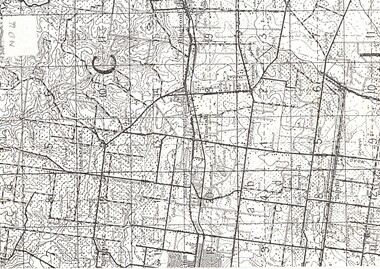
Map, Orchards 1922, 1922
... 1922 map showing orchards in Doncaster East, Blackburn... tally ho east doncaster 1922 map showing orchards in Doncaster ...1922 map showing orchards in Doncaster East, Blackburn, Mitcham, Tunstall, Ringwood, Vermont, East Burwood, Tally Ho.vermont orchards, tunstall, ringwood, blackburn, tally ho, east doncaster