Showing 121 items
matching farm sheds
-
 Southern Sherbrooke Historical Society Inc.
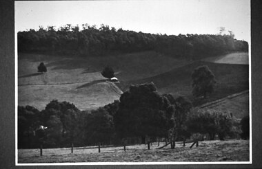
Photograph - Glen Park Farm, Selby
B&W photo showing Glen Park Farm, Selby, owned by the Johns family, as seen from the north-east corner. Photo shows the descent to the valley then up Black Hill in the background. Mostly cleared paddock apart from the cypress avenue to the farmhouse (which is glimpsed between the trees) a few single trees dotted about, and the heavily treed area on the top of Black Hill. There is a small building or shed or possibly a haystack in the centre of the photo. -
 Southern Sherbrooke Historical Society Inc.
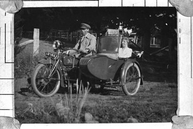
Photograph - Percy and Cissie Johns at Glen Park Farm
B&W photo of Percy and Cissie Johns at Glen Park Farm. Percy is astride a motorbike, reg # 12169, wearing a light coloured jacket over a shirt and tie, and wearing a peaked cap (similar to a uniform cap). Cissie is seated in the sidecar. She is wearing a light blouse and she is smiling. The sidecar has a folded-down roof and a windscreen. There are sheds and trees behind them. -
 Friends of Westgarthtown
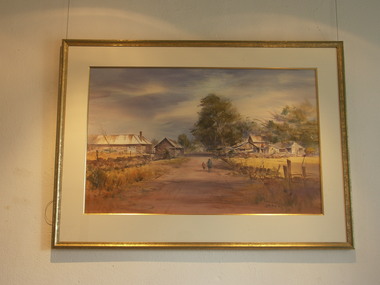
Painting, John Borrack, Ziebells, German Lane, South View
Painted from Gardenia Road. The extensive farm complex on the right. (Western side of Gardenia Road). was demolished in 1972 for housing development. Buildings shown are cowshed, hay barn, engine shed and stables. Painted in the late afternoon, the lengthening shadows and lowering sky, could presage the ominous fate awaiting the farm with development. The Ziebell Farm was known as “The Pines†and sadly none of the many that proliferated there remain. Today they would be equivalent to those at the cemetery, having been planted at the same time. Provenance: John Borrack CollectionWatercolour depicting Ziebell Farmhouse from the north, Thomastown and Mernda. In gold frame with cream border.Artist signature: John Borrack; 70's Ziebells German Lane South Viewillustrations, watercolours, john borrack, ziebell, watercolour, painting -
 Stawell Historical Society Inc
Photograph - Yard Scenes at 'Whitehall', Hutchings Farm “Whitehall” -- 3 Photos
Hutchings family property “Whitehall” 3 Scenes Shows large Haystacks Sheds Cows extensive Garden. Avenue of trees. These copies were taken from the Hutchings Family album.Three (3) Sepia Photographs. 204 Titled Whitehall Avenue: An avenue with wooden fences including people on on left three on right including one woman. 204.1 Titled Yard at Whitehall: 4 Men with herd of cows in foreground, man in front holding a metal bucket. Large Hay stacks behind. wooden shed with metal roof on right. 204.2 Part of Whitehall: Windmill and wooden buildings behind Wooden Picket fence in background. 204: Whitehall Avenue 204.1 Yard at Whitehall 204.2: Part of Whitehall All enclosed in a box, which is above a line of solid triangles over a thin linestawell -
 Surrey Hills Historical Society Collection
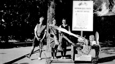
Photograph, Chatham students support the Empire, Surrey Hills, c 1947, 1947
The billycart was possibly decorated for celebrations associated with Empire Day. Image was originally copied by Chatham Primary School for inclusion in their pictorial history "A Patchwork of People - Chatham Past and Present" [ISBN 0 646 29370 2], by Susan Barnett and Julia Ashby, published in 1996 for the school's 70th anniversary. Copied for the SHNCHC with the school and donor's permission. There is also a laminated copy of it for display purposes.Black and white image of four boys and their billycart. Two are identified as Bruce Hansen, standing behind the flag and Jimmy Boyd, seated in the billycart, which is decorated with streamers, an English flag and advertising signs promoting Australian sultanas and the export of Australian dried fruit to the [British] Empire. The photo was taken in the grounds of Chatham Primary School. In the background can be seen some of the cypress trees that were planted along the side of the oval, a remnant eucalypt from the time when the land was part of J B Maling's farm and part of the shelter shed.chatham primary school, billycarts, advertising signs, empire day, bruce hansen, jimmy boyd -
 University of Melbourne, Burnley Campus Archives
Plan - Coloured plan, Plan of Burnley Gardens, 1929?
Layout of gardens, farm buildings, orchard, etc. overlaid on part of Lands Department map. See paper catalogue for full descriptionPart of larger plan (Lands Department Parish Plan). Partly hand-drawn. Area bounded by Yarra River, Swan St, Glen Iris railway line. Shows Burnley Gardens layout, handwritten amendments and explanation of existing and proposed structures including: Pavilion, sketch of unbuilt Administrative Building, poultry yard, contours of old orchard, sketch for Plant Research Institute, ditch, silo, milking shed, laying pens. See aboveburnley gardens, pavilion, burnley school of horticulture, farm buildings, poultry -
 University of Melbourne, Burnley Campus Archives
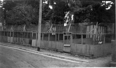
Photograph - Black and white print, Old Poultry Pens, 1941
Note by T.H. Kneen 13 May 1992, "The Poultry Pens photographed in this and succeeding photos B91.310-311 were located east of the milking shed and were remnants of early facilities for small farm instruction."Black and white photograph.Poultry Pens with 2 hens visible.One of a group of photographs inscribed, "Xmas break-up December 1941."1941, poultry pens, egg-laying competition, small farm instruction, poultry -
 Melton City Libraries
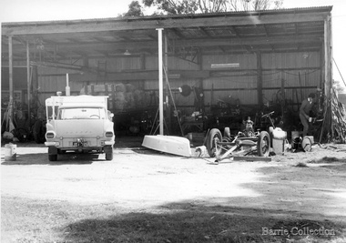
Photograph, Shed workshop at Ferris Rd, Unknown
Black and white photographs of farm vehicles at the workshopagriculture -
 Melton City Libraries
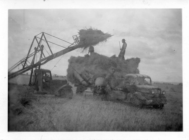
Photograph, Harvesting, 1950
1950 decade HAY FORK - A local invention. Bill and Arthur Gillespie and Bon Barrie In the early 1950’s Bill Gillespie of Bulmans Lane had been experimenting in developing a machine to improve the collection of hay sheaves at harvesting and stack building time. The ripened crop was cut by a reaper and binder which bundled the storks into sheaves tied with binder twine. The reaper and binder was towed by a tractor by the mid 1940s previously teams of draught horses were used to pull the reaper and binder. A photograph taken at the Barrie farm shows three binders the first being towed with a tractor and the others with horse teams. Two workmen were needed to operate the binder when cutting a crop. The sheaves collected on the binder and released onto the ground and were scattered across the paddocks. Using a conventional two pronged pitch fork the harvest hands collected the sheaves and placed each one cut edge on the ground in an upright position and layered with about 15 sheaves into an apex shape to form was is known as a stook. The shape of the stook allowed for drying and draining of water if rain had occurred. Prior to the invention of the mechanical hayfork this was a laborious task requiring each sheaf to be pitched onto a tray truck and moved to the location of the haystack. The mechanised HAYFORK was operated by one person on tractor greatly reducing the need for gangs of labourers. At harvest time farmers had relied on itinerant teams of workers descending on the district looking for work. The three Barrie brothers on their adjoining farms combined forces to cut their crop at its optimum time while the weather was in their favour. Up to many 20 workers at times formed a team in earlier times. Agricultural university students were also keen to gain practical experience in the field. Each of the brothers had a particular skill, and Tom Barrie was the expert on stack building. The district haystacks had a distinctive shape and could be recognised by their builder. Bill Gillespie’s first operational HAY FORK consisted of a large 13 pronged fork situated forward of the truck cabin. It was attached with iron girders and mounted on the rear of the cabin to the tray of his British Bedford truck. It was constructed in metal and iron and welded in the farmers work sheds. The mechanism was raised and lowered by the driver scooping along the ground to pick up a complete stook to raise high enough to deposit all the sheaves in one stook onto the stack or truck tray. The fork section was released by a rope and operated by the driver in the cabin. This model was trialled on the Barrie farm at Ferris Lane. It proved to be very successful and the Barrie/ Gillespie brothers went on to develop a HAYFORK which attached to a tractor and was operated with a series of levers and was raised and lowered hydraulically. It was detached from the tractor when stacking was completed. In its early days farmers travelling along the Western Highway called at the Barrie farm at Ferris Lane to inspect its construction and operation of the invention. It became a widely adopted by farmers throughout the State. It was being used on Wattie Palmer’s farm on Bridge Road Melton South in 1997. Farming in Melton, hay growing and stack building. agriculture, local identities -
 Melton City Libraries
Document, Minns Family Reunion, 2004
"A perpetual spring in the adjacent creek provided a steady supply of fresh water to the site on which the homestead is built. Although we can not be certain of the identity of the builder, the first stage of ‘The Willows’ homestead appears to have been constructed in the mid 1850s. The house is situated on Crown Allotment No.1 (No Section), Parish of Kororoit, an allotment of 5 acres 3 roods 4 perches. Although it had surveyed the land, the Crown did not offer it for sale until 22nd November 1861, at which time it was purchased by Charles March Williams. (Although the property is directly opposite and immediately adjacent to the Township of Melton, and was sold as ‘Suburban Allotment 33’, it was situated within the Shire of Braybrook rather than the Shire of Melton until 1917.) Considerable improvements had taken place on the land prior to the Crown sale. When CM Williams purchased the allotment in November 1861 he paid £23.5.0 for the land itself, and valued the improvements at £400. Even allowing for some exaggeration by Williams, this is an extremely high valuation for improvements, and must have included a house. Some local research has claimed that in 1858 Williams had taken over the interest of a Mr Parkinson in the property, and that Parkinson built the house upon taking possession of the land c.1855. It was definitely built by 1861, when a map shows a square building on the site marked as ‘House’. The property is important in the district for its association with the establishment of the pound. The district pound had been established in 1854, when George Scarborough of Mount Cottrell (Mt Cottrell Road, south of Greigs Road) was appointed pound-keeper. Scarborough resigned in 1857. The pound was moved to Melton following agitation from local farmers and Charles March Williams appointed pound-keeper on 26th April 1858. Williams, the son of a doctor, had been born in London. Reminiscences of local residents of the time, as recorded in the Express newspaper, note Williams’ success in breeding horses on the property. Sales of up to 60 guineas were noted. Whether this was from Williams’s own stock or from unclaimed pound stock is not made clear. Williams appeared before a government inquiry in 1860 and advocated registration of all stock brands in the State. Williams died in 1862 leaving a widow, Catherine, and five living children aged 15 years to five months. At the time of his death Williams had entered negotiations with one Matthew Devenish and had a mortgage of £100 on allotments 1 and 2, Parish of Kororoit. Catherine Williams was appointed pound-keeper on 2 September 1863, with her eldest son Charles as her assistant. Her tenure was short for on 22nd March 1864 George Minns senior paid Matthew Devenish £135 for allotments 1 and 2 Parish of Kororoit (considerably less than Williams had claimed the property was worth in 1861) and on the same day paid William Tullidge £45 for the adjoining allotments 3 and 4. In April 1867, James Ebden Minns, the newly married son of George senior became the owner of The Willows property having entered into a mortgage arrangement with his father to the extent of £200. At the time George Minns was residing in Kaarimba having left Melton in 1867 for a short trip to England and upon his return having taken up a selection in the Kaarimba district with his son Frederick who had a hotel licence there. James paid out the mortgage on 2-1-1873. James Minns was appointed pound-keeper in 1872; in 1885 the pound was moved elsewhere and Minns purchased the old pound site and added it to his farm. The Willows residence underwent a major change about this time. A two room extension, similar in style but with a lower elevation was added to the original rear of the house with a chimney matching the distinctive originals. Window arrangements did not match the original but became a feature of the façade when the new addition became the front of the building. Six buttresses were attached to the east and west walls of the old building, two to the south wall and the whole rendered with mortar to give the appearance of dressed stonework around the windows. Galvanized iron was placed over the shingles and a verandah added on three sides. By 1876 The Willows was the homestead for a thriving mixed farm of 340 acres of which 156 was rented from a H. Ruck. In October of that year the Australasian travelling reporter visited and reported on the property. In common with the nearly every other property in the district the farm had ‘recently’ (generally within the last two years) abandoned cultivation of crops, and turned over completely to cattle pasture. Butter making was the principal occupation of the farm, which had about 50 head of cattle, a large proportion of which were milking cows. The reporter also noted that a ‘large number of pigs are kept upon this farm and are found to be very profitable stock’. Their manure was used in an orchard and garden in which ‘large quantities of lucerne and prairie grass are grown for the use of stock when ordinary feed is scarce’. Two bores attached to deep brick lined wells supplied water for the house in addition to the farm. A commodious timber barn and necessary sheds had also been constructed. Access to the property was improved following the construction of the bluestone ford across the creek c.1887, when the recreation ground came into use. Prior to this date it may have been that the crossing referred to as ‘Mr Minns bridge’ was used. This appears to have been a flimsy structure and has but two references in Council reports in the Melton Express in the 1880’s. It is believed that in the late 1890’s a timber building was added near the rear of the building to house a kitchen, ablutions and laundry rooms and rooms for seasonal workers. This was attached to the house by means of a trellised walkway using the original front entry to the house (long since the back door). A photograph of this building appears in a local history of Melton. This was demolished in recent decades during the period when the house was tenanted (after the Minns family had left). James Minns son, George, took over the property following his marriage to Alice Walsh in 1903. James and Caroline moved into a house on the former JH Games property at the eastern end of Henry Street. George held the position of Shire Secretary for Melton for 40 years. He was a most prominent member of the community being Secretary to, among others, the Melton Coursing Club, the Shooting Club and the Cemetery Trust. He also rode with the hunting parties who sported across the Plains and were entertained at Mount Kororoit. George and Alice had one son, Norman who followed his father into local government and became Secretary of the Shire of Werribee completing a record term in this position. George retired to Werribee in 1951, where he died in 1965. The National Trust records note that James Ebden Minns and his sons were ‘leading men of the district, Justices of the Peace, and Shire Councillors’. It claims that Sir Thomas Bent was a frequent visitor. The Willows passed into the hands of George’s grandson, Bruce Minns and the property was let for a number of years. In the 1960s it became vacant and was subject to vandalism. Major structural problems arose with the part demolition of the roof, the loss of windows and doors and holes dug into and under the floorboards. The outbuildings were particularly targeted. Following widespread public support, the Shire of Melton purchased the house, with 3.75 acres of land, in 1972. In 1975 the Shire of Melton and the Melton and District Historical Society were successful in nominating the building for National Trust classification, and then the Australian Heritage Commission’s Register of the National Estate. The AHC particularly noted its ‘townscape importance’. It was envisaged that the farmhouse would form ‘a picturesque centrepiece to Melton’s planned … historical park, along with Dunvegan bluestone cottage … and similar structures as they become available.’ In a time of great Melton’s ‘satellite city’ development the Council spelt out its broader vision in its submission to the AHC: ‘Melton is destined to become, by the end of the present century, a city of between 75,000 and 100,000 people. Significant relics of the past, such as ‘The Willows’, regrettably will be rare in that situation. It is essential that sufficient tangible links with Melton’s pioneering days remain to promote in the new community a sense of history and continuity’. Under the direction of ‘The Willows’ Restoration Committee and consultant architect John Hitch, all outbuildings, with the exception of the garage and toilet, were demolished and the dwelling house restored. Finances were provided by the Shire of Melton and the National Estate Grants Program, and considerable amount of voluntary labour was provided by the local community. The orchard was removed, and remaining wooden buildings were relocated to provide an open vista for visitors to the Park. The property was furnished with donations from district families keen to preserve this example of pioneer life in the area. The Willows became the headquarters of the Melton and District Historical Society". Invitation to the family reunion at the Willowslocal identities, pioneer families -
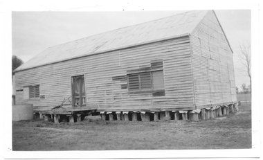 Tarnagulla History Archive
Photograph of shed on Metelman's farm (formerly Herd's Store), Shed on Metelman's farm (formerly Herd's Store), 25/071968
... Photograph of shed on Metelman's farm (formerly Herd's...Shed on Metelman's farm (formerly Herd's Store)... door. Shed on Metelman's farm (formerly Herd's Store ...Murray Comrie Collection. Information collated by Murray Comrie: This building was formerly Herd's Store in Tarnagulla, moved to Metelman's farm in Arnold West to be used as barn (as was as late as May 1970). This photograph is an original print, made in 1968. Monochrome photograph depicting a large weatherboard building on stumps, in a paddock. Three louvre windows and central door.tarnagulla, commerce, shops, stores, herd's, commercial road, main street, metelman, farming, arnold west -
City of Kingston
Photograph - Colour, 6 March 1993
Edithvale is a suburb in the City of Kingston. It is located between Aspendale and Chelsea on the Port Phillip Bay and built within remnant areas of the Carrum Carrum swamp. The foreshore precinct comprises a wide sandy beach, with low sand dunes and numerous historic boat sheds. The suburb consists of older style dwellings and former holiday houses, combined with mid-century housing and newer homes. The large blocks are increasingly subdivided and the existing dwellings demolished to accommodate units and townhouses, thus changing the landscape of the area and reducing the tree canopy.The beachside suburb of Edithvale was previously part of the extensive Carrum Carrum Swamp. The area was once a source of fish and eels for the Mayone-Bulluk clan of the Bunurong people. Over time the area was drained and predominantly devoted to dairy farming and holiday houses. The farms were gradually sold and subdivided with a large number of homes built after World War II and in the 1960s. Edithvale is mainly residential with a shopping strip along Nepean Highway but little significant industry was ever established in the area apart from a plaster works and confectionary factory, both now closed.Laminated aerial colour photograph of Edithvale as viewed from Alexandra Avenue in the north to Ella Grove Chelsea/Edithvale in the south. regents Park Aspendale can be seen in the top left. The area is built-up with residential housing and facilities including Edithvale Primary School, numerous churches and the Edithvale Railway station. Large sections depict the remnant Carrum Carrum swamp. Edithvale Common and the former "Duck Inn" (Melbourne Water/Friends of Edithvale Seaford Wetlands) can be seen. Edithvale Recreational reserve, the valodrome and Edithvale Public Golf Course are prominent. The image shows vacant land in the area now known as Aspendale Gardens and the newer residential section of Chelsea Heights is not developed. A bike path has been established to cover the secondary drain. The Golf Links Court residential development located off Hughes Avenue is a large vacant block.Black type on white adhesive label: 6-3-93 Black type on white adhesive label: 25/9211, 6/3/93, 11.20 am Black type on white adhesive label: 9211 Yellow circular adhesive sticker Black pencil: 9211 6-3-93 arrow pointing Nedthvale, carrum carrum swamp, aspendale, chelsea -
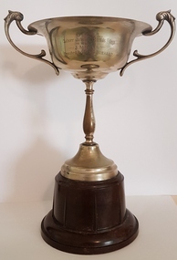 Linton and District Historical Society Inc
Trophy, Silver Jubilee 120 Yards Handicap, 1939, 1939
... Won by J. Megee 1939- found 2002 by his son in sheds...Won by J. Megee 1939- found 2002 by his son in sheds ...Won by J. Megee 1939- found 2002 by his son in sheds on their blueberry farm at Monbulk. A visiting friend, G. Smith of Ballarat (formerly Mannibadar) rescued it from the garbage skip and offered to bring it to the Society. Donated by Megee family.Silver plated cup on brown Bakelite base."O.L.A. Silver Jubilee 120 yds HDCP Won by J. Megee Donated by Cr. N.G. Wishart 8.4.39".j. megee, old lintonians association, n.g. wishart, trophies -
 Lakes Entrance Historical Society
Photograph - Cricket, 1999
... Concrete bricks formed pattern mould, made in shed...Concrete bricks formed pattern mould, made in shed ...Concrete bricks formed pattern mould, made in shed at Kimmell's farm by Clyde Worseldine, WW2 returned service man, in employ of Tambo Shire.Colour photograph of a concrete brick afternoon-tea pavilion built 1946c for Lakes Entrance Cricket Club. Building has a chimney at each end and corrugated iron roof, sited flush of south fence of Recreation Reserve. Also in image small wooden shed which was moved from Post Office residence 1960c when Post Office was extended. Lakes Entrance Victoriasports, cricket, buildings -
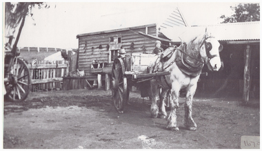 Linton and District Historical Society Inc
Photography, Gillett with Horsedrawn Cart
Black and white copy of original photograph of grey bearded man with hat standing behind, child sitting in cart with horse. Sheds and buildings in background.gillett, horses, farm -
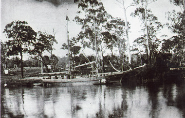 Lakes Entrance Historical Society
Photograph - Ethel BT, 1900c
Captain ..Limschow, crew member A J legg and two others were rescuedBlack and white photograph showing schooner Ethel BT in Tambo River near Bennetts Brook. Sheds and buildings and post and rail fences on farm in background. Swan Reach Victoria boats and boating, waterways -
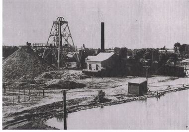 Bendigo Historical Society Inc.
Photograph - BLACK AND WHITE PHOTOGRAPH OF THE NORTH DEBORAH MINE
North Deborah Mine in Eve Street, Bendigo, operated between 1937 and 1954. In that time it produced 128,000 ounces of gold.Black and white photograph of the North Deborah Mine, showing the poppet head, mullock heap to the left, man at the end of railway at the first level, does not show cables from the engine house to the wheels on top of the poppet, water tank at the side of the engine house, farm style corner of a fence at left of photo, small shed housing a pump for water, right foreground is a dam for water waiting to be converted to steam to operate the cable winder.mining, surface equipment, north deborah mine -
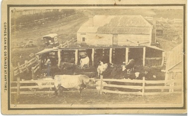 Bacchus Marsh & District Historical Society
Photograph, Dairy Farm Bacchus Marsh District 1883
The number of cattle in this photo suggests that it was a small holding, at the beginning of the dairy industry in Bacchus Marsh. This industry became a major source of employment in Bacchus Marsh. By the early twentieth century, the Bacchus Marsh region was a significant contributor to the dairy industry in Australia. Small sepia unframed photograph on card with gold border framing photograph. Housed in the album, 'Photographs of Bacchus Marsh and District in 1883 by Stevenson and McNicoll'. This is a photo of a dairy farm in an unknown location in the Bacchus Marsh district. It has been taken from an elevation looking down at the farm. On the left, the roadside can be seen running alongside a stream or river which is fenced off by a line of trees and a post and rail fence. Parked on the road outside the farmhouse is a wagon which is unhitched. The wagon has a white rooftop and on the side can be seen a professional logo, details unclear. This wagon is most likely the wagon used by the photographers to access outlying properties with their photographic equipment. The farmhouse itself faces the road with side doors giving onto the yard. The roof is partially covered by new slates, possibly slate covering bark. Six milking sheds of post-and-rail construction adjoin the farm yard. In the first and fourth stalls (l to r) the farmer and his wife can be seen seated, miking cows. The rest of the herd are awaiting milking in the yard which also has a post-and-rail fence. A bull of milking shorthorn breed stands outside the fence. The milking herd itself is of various breeds; Herefords, roan shorthorn and roan and white shorthorns can be identified. On the right is a shed of rough-hewn boards and a shingle roof. In the yard at the back of the house stands a cart or dray. On the front: Stevenson & McNicoll. Photo. 108 Elizabeth St. Melbourne. COPIES CAN BE OBTAINED AT ANY TIME. On the back: LIGHT & TRUTH inscribed on a banner surmounted by a representation of the rising sun. Copies of this Portrait can be had at any time by sending the Name and Post Office Money Order or Stamps for the amount of order to STEVENSON & McNICOLL LATE BENSON & STEVENSON, Photographers. 108 Elizabeth Street, MELBOURNE. dairy farms, stevenson and mcnicoll 1883 photographs of bacchus marsh and district -
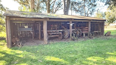 Old Gippstown
Building - Shed
... Farm shed... the 1970s shed Old Gippstown West Gippsland Gippsland Gippsland ...Built at Old Gippstown from secondhand materials during the 1970sRectangular-shaped timber shed, with a corrugated iron roof. It has a back and two side walls, while the front is open for access.shed, old gippstown, west gippsland, gippsland, gippsland heritage park, goldfields, coal mine, victorian era, moe, historical village, bushy park, old gippstown heritage park, latrobe valley, farm shed, latrobe city council, gunaikurnai -
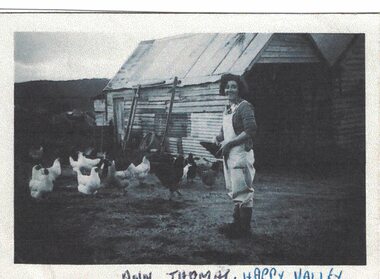 Linton and District Historical Society Inc
Photograph, Ann Thomas
Black and white copy of original photograph of a lady wearing light coloured overalls and rubber boots, outside with chickens, a weatherboard shed in the background.ann thomas (nee hanrahan), farm, chickens -
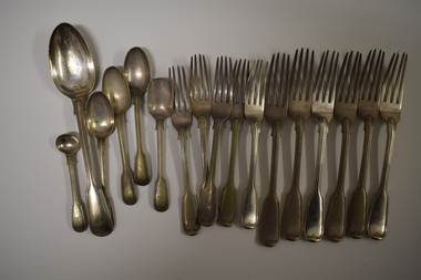 Warrnambool and District Historical Society Inc.
Functional object - Cutlery, George Rolfe, Mid to late 19th century
In 1854 in Melbourne George Rolfe Senior established an import business dealing in groceries, wines and spirits and tea. His son George, born in England, took over the business of Rolfe and Co in 1871. A keen sportsman, George Rolfe’s love of fishing led him to take frequent holidays in Warrnambool. He began buying blocks of land near the mouth of the Hopkins River in Warrnambool in the 1870s. By the 1880s Rolfe owned 50 acres in the Hopkins River area and named the property, Lyndoch. He built stables, chaff and bone sheds, a jetty, a boatshed, a water well, a windmill, a reservoir and extensive gardens. He also bought the nearby properties of Shipley and Fairy Hill, establishing a stud farm and breeding cattle. In 1891 he married Jane Ann Lake, the widow of his property manager, and when he died in 1919 his step-daughters, Florence and Annie Lake, inherited Lyndoch. The property was sold and became an aged care facility in 1952. The cutlery items were in use in the building erected by Florence Lake in 1920 and known today as Lyndoch but the ‘R’ monogram on the items suggest that they belonged to George Rolfe or even his father before him.These cutlery items are of considerable importance as mementoes of George Rolfe and his family. They were prominent in Warrnambool’s history in the late 19th and early 20th centuries with the establishment and development of the property, Lyndoch, near the mouth of the Hopkins River. These are 17 pieces from a silver cutlery set that belonged to the Rolfe family (one tablespoon, six large forks, five smaller forks, four small spoons and one mustard spoon.) All the pieces of cutlery have a monogrammed ‘R’ at the end of the handles. Twelve of the items are tarnished and one small spoon is very worn. All the items have six hallmarks. ‘R’george rolfe, lyndoch, warrnambool, rolfe & co. melbourne, florence lake, lyndoch warrnambool., history of warrnambool -
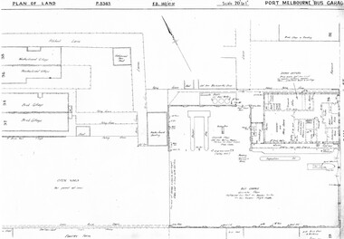 Melbourne Tram Museum
Drawing, Melbourne & Metropolitan Tramways Board (MMTB), "Port Melbourne Bus Garage", c1938
Set of five photocopied plans or drawings on A3 sheets of the "Port Melbourne Bus Garage" .1 - P8383 - Plan showing building layouts and adjacent land - including a Poultry Farm - dated 1938 .2 - P8416 - Plan showing parts of the adjoining properties including houses. .3 - Unnumbered - more modern architects drawing showing details of offices - c1944? - two sheets. .4 - unnumbered - drawing showing layout of repair shed, pits, offices and mess room facing Bay St. Copy of the map from Melway Street Directory No. 1 from Kevin Staines 24-2-2018 - added 9-3-2018. See image i6trams, tramways, drawings, depots, property, port melbourne, buses, maps -
City of Kingston
Photograph - Colour, Circa 1993
Edithvale is a suburb in the City of Kingston. It is located between Aspendale and Chelsea on the Port Phillip Bay and built within remnant areas of the Carrum Carrum swamp. The foreshore precinct comprises a wide sandy beach, with low sand dunes and numerous historic boat sheds. The suburb consists of older style dwellings and former holiday houses, combined with mid-century housing and newer homes. The large blocks are increasingly subdivided and the existing dwellings demolished to accommodate units and townhouses, thus changing the landscape of the area and reducing the tree canopy.The beachside suburb of Edithvale was previously part of the extensive Carrum Carrum Swamp. The area was once a source of fish and eels for the Mayone-Bulluk clan of the Bunurong people. Over time the area was drained and predominantly devoted to dairy farming and holiday houses. The farms were gradually sold and subdivided with a large number of homes built after World War II and in the 1960s. Edithvale is mainly residential with a shopping strip along Nepean Highway but little significant industry was ever established in the area apart from a plaster works and confectionary factory, both now closed.Aerial colour photograph of Edithvale as viewed from Alexandra Avenue in the north to Ella Grove Chelsea/Edithvale in the south. The area is built-up with residential housing and facilities including Edithvale Primary School, numerous churches and the Edithvale Railway station. Large sections depict the remnant Carrum Carrum swamp. Edithvale Common and the former "Duck Inn" (Melbourne Water/Friends of Edithvale Seaford Wetlands) can be seen. Edithvale Recreational reserve, the velodrome and Edithvale Public Golf Course are prominent. The image shows vacant land in the area now known as Aspendale Gardens and the newer residential section of Chelsea Heights is not developed. A bike path has been established to cover the secondary drain. The Golf Links Court residential development located off Hughes Avenue is a large vacant block.Yellow circular adhesive sticker on plastic Black ink (marker): * (asterisk) Black type on white adhesive sticker: P000108edithvale, aspendale, chelsea, carrum carrum swamp -
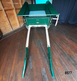 Flagstaff Hill Maritime Museum and Village
Vehicle - Tip Dray, Prior to 1930s
A Dray is a type of dead axle wagon that was used to transport heavy loads or objects. They had a flat level floor and while some had no sides, others had box bodies and sides. Tip Drays (also known as Tip Carts, Muck Cart, Scotch Cart, Tumbrel or Putt in different parts of England) were smaller than other drays as their loads were heavy and usually only pulled by one horse. Their basic design included two wheels, a tipping body and shafts. The Tip Dray has a unique mechanism that allows the top to tip backwards to tip the load out of the back of the dray. The tipper was activated by a handle at the front allowing the driver to operate it while still having control over the horse. A Tip Dray was an indispensable piece of equipment in the days before tractors and mechanical trucks. They were used by farmers and carters to transport hay, rocks, bricks, gravel and rubbish etc. and because they were useful for dumping loads, they were favoured for use in road and railway construction. A photo in the collection of the Lorne Historical Society shows a tipping dray being used during the construction of the Great Ocean Road. They were part of the daily street traffic in towns and cities around Australia from the early days of settlement. In Australia in the early 1900's, carters began to join unions to protect their jobs and pay. N.S.W. had a "Trolley, Draymen and Carters Union", Queensland had a "Tip Dray Men's Association" and in W. A. the "Top Dray Driver's Union" had a "cessation of work" in 1911 when they were fighting for an increase in their day's wages. In 1910 a meeting of Tip Carters was held in Geelong at the Trades Hall to discuss the formation of a union (The Geelong Tip Dray Carters) which was a success and a schedule of rates for all carting, whether by contract or day labor, was fixed. By 1912 they had "labelled" more than 50 drays and had representatives on the "Trades Hall and Eight Hours Committee". By the mid 1930's and early 1940's, tip drays were being superseded by mechanical trucks and utes. However tip drays continued to be used in some circumstances. They were a practical solution to the problem of petrol rationing during W. W. 2. It was noted in a letter to the editor in the "Sunshine Advocate" in 1938 that a positive argument for continued use of Tip Drays for rubbish collection related to the idea that a horse drawn vehicle involved with lots of stops and starts at different houses (very like a milkman's delivery route) often involved the horse "driving itself" while the driver picked up the rubbish - something a motor truck was unable to do! Another article written in August 1935 and published in the Age in a parliamentary report into the rubber industry noted "tip drays had almost disappeared and in their place, metal was carted in 5 ton motor trucks" but the report went on to say that as a part of the Government relief work (during the Great Depression) the Government had "to some extent reintroduced the tip drays so that a greater number of men would be employed". This particular tip dray was owned by Mr. Oswald (Jack) Bourke. He used it to deliver dry goods from Sunbury to the Queen Victoria Market in Melbourne several times a week in the 1930's and then (between 1945 and 1962) Mr. Bourke used it on the garbage round in Springvale Victoria for the Springvale Council. The Council owned three drays and the "No. 3" painted on this dray is in recognition of its original number. After the death of Mr. Bourke in 1990, one of Mr. Bourke's sons (Andy) found the dray in a shed and restored it. The sign writing on the back and side panels were added during the restoration. This Tipping Dray is a significant example of a horse drawn vehicle that was used by workers from the early days of white settlement through to the 1940's and even into the early 1960's. It was used in a range of "working class" occupations - road construction, railway construction, carting goods, rubbish collection etc. and would have been found in cities, country towns and on farms.A wooden and metal tipping dray with a box body and four sides. It has two iron and wooden wheels (with 14 spokes), two wooden shafts and a metal tipping mechanism. The back panel folds down to allow loads to be dumped out. It is painted in green and cream with sign writing on one of the sides and on the front and back panels. It features decorative painted lines and designs in burgundy, cream and light blue on most of the wooden parts. The tipping mechanism is on the front of the dray's left side and consists of a metal pin secured with a metal ring, and a lever.Front of dray - "No. 3" Side of dray - "A. & M. BOURKE / Contractors / LONGWARRY" Back of dray - "G.T. ANDREWS / QUEEN VICTORIA MARKET - Stand C23 / Phone DANDENONG 225"flagstaff hill maritime museum and village, warrnambool, shipwreck coast, tipping dray, dray, tip dray, tip cart, vehicles, horse drawn vehicle, springvale council, jack bourke, muck cart, scotch cart, tumbrel, putt, box body, oswald bourke, sunbury, queen victoria market, melbourne, no. 3 -
 Wodonga & District Historical Society Inc
Photograph - Mrs. Ronan's Dining Room, Wodonga, c1914
When Mrs Julia Ronan nee Arundel lost her husband John to tuberculosis in 1906, she quickly decided to move from their small farm into Wodonga with her 3 children. She was granted the lease of the ground she needed to establish her eating house at one shilling per year in a shed on the Dalgety's saleyard block. Two established merchants Albert Schlink and John Whan and butcher Jack Garrett agreed to allow her credit which enabled her to open Ronan's Dining Rooms at the Saleyards. It was often a challenging environment, with drovers, and horse- breakers, auctioneers and bushmen bringing huge mobs of cattle and horses to the saleyards. Stories of the premises include the unexpected arrival in the passage of a lively bullock which finished up on the girls' bed. Mrs Ronan persevered and beat all obstacles to finally move from the saleyards to the Wodonga Coffee Palace in High Street, beside the railway gates in 1921. The construction of the Hume Weir had begun and some construction workers boarded at the Coffee Palace. Her 3 children achieved success due to their mother’s hard work to ensure their futures. Bill trained for the priesthood and was a parish priest, but died from tuberculosis 1n 1939 aged of 41. Katie became a highly accomplished music teacher, including 32 years at Albury Public School. In the 1930s she was able to buy a house at 49 High Street, Wodonga where she lived with her mother and sister Mary. Mary trained in office work at Edmondson’s solicitors and then worked on the Albury Council. After living with her daughters in the High Street house, Julia passed away on her 90th birthday in 1958. Mary died on 6 January 1983. Katie passed away in Wodonga at the age of 97 on the 16 September 1996. All members of the family are buried at Yackandandah, Victoria.A black and white image of Miss Mary Ronan, Mrs Julia Ronan and Miss Teresa Trudewind at the Old Saleyards Dining Room, Wodonga.On front of building: DINING ROOMS/ MRS. J. RONANmrs. ronan, dining rooms wodonga sale yards, wodonga businesses, wodonga pioneers -
 Wodonga & District Historical Society Inc
Photograph - Mrs Ronan's Dining Rooms
Before the construction of the Wodonga Municipal Saleyards which opened in 1935, there were four private saleyards which operated in Wodonga. They were owned by Gippsland & Northern Co-Operative Co. Ltd., Dalgety & Co., New Zealand Loan & Mercantile Agency Co. Ltd. and Younghusband Ltd. When Mrs Julia Ronan nee Arundel lost her husband John to tuberculosis in 1906, she quickly decided to move from their small farm into Wodonga with her 3 children. She was granted the lease of the ground she needed to establish her eating house at one shilling per year in a shed on the Dalgety's saleyard block. Two established merchants Albert Schlink and John Whan and butcher Jack Garrett agreed to allow her credit which enabled her to open Ronan's Dining Rooms at the Saleyards. It was often a challenging environment, with drovers, and horse- breakers, auctioneers and bushmen bringing huge mobs of cattle and horses to the saleyards. Stories of the premises include the unexpected arrival in the passage of a lively bullock which finished up on the girls' bed. Mrs Ronan persevered and beat all obstacles to finally move from the saleyards to the Wodonga Coffee Palace in High Street, beside the railway gates in 1921.This item is significant because it captures one of the private saleyards which operated prior to the establishment of the Wodonga Municipal Saleyards.A black and white image of the sale yards at Wodonga c1907 with the dining room operated by Mrs Ronan on the right.Beneath image: View of Wodonga Mrs Ronan's Dining c1907 Wodonga Sale site, Corner Elgin (Melbourne Road) and Smythe Street, replaced by Municipal Saleyards in 1935. Photo: Bob Prentice, Donated by Mrs Val Phefleywodonga saleyards, mrs julia ronan -
 Churchill Island Heritage Precinct
Machine - Wool Press
The Churchill Island collection includes objects from the 18th and 20th centuries. The collection is presented in sets and series, of which this object belongs to the National Trust sub-collection.Wool presses were used in shearing sheds around the country to create bales of wool by hand in preparation for transport to the wool markets for purchase and distribution. Bales have been used to store and were a standard trading unit for wool for centuries. A standard wool bale holds about 60 compressed wool fleeces and weighs a minimum of 120 kgs. The square shape and weight enabled them to be stacked on wagons or in warehouses, and a large pack horse could carry one on each side. Large, retangular upright metal wool press, unpainted with some surface rust.farm machinery, wool, wool press, hand operated, shearing, national trust -
 Old Gippstown
Building - Coach House
Built in the 1920s on Tom Fowler's farm at Willow Grove. Used as a shed.A large square-shaped shed with walls of split timber. It has a gabled roof of corrugated iron, while the floor is made up of wooden cobbles. The roofs of the side extensions are made of wood. The floor is Red Gum blocksagriculture, old gippstown, west gippsland, gippsland, gippsland heritage park, goldfields, coal mine, victorian era, moe, historical village, baw baw shire, willow grove, latrobe valley, old gippstown heritage park, horse drawn vehicles, butchers cart, baker's cart, tanjil valley, latrobe city council -
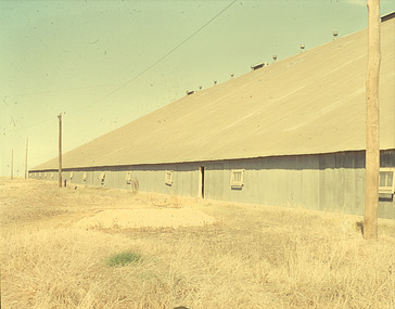 Bendigo Historical Society Inc.
Slide - Mouat Crawford Collection: Farming Life in the Wimmera
Wheat terminal at Murtoa, known as the stick shed Markings: Murtoa(SIC) Bulk Wheat Terminal. The Stick Shed. Used as a teaching aid.PERUTZagriculture, farm, crop storage, wimmera, wheat silo, stick shed, murtoa, mouat crawford collection -
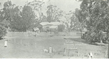 Lakes Entrance Historical Society
Photograph, H Cooper, The Lodge Nyerimilang, Kalimna West Victoria, 1910 c
The Lodge was the residence of the farm manager at Nyerimilang estateBlack and white photograph of The Lodge Nyerimilang showing back of building with old paling fence alongside, shed at right under large tree and lady with white calf and two little girls Kalimna West Victoriafarm