Showing 246 items matching "grassed area"
-
 Eltham District Historical Society Inc
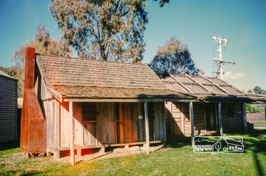
Photograph, Autumn Excursion, Hume and Hovell's 1824 expedition, 26 May 1996, 26/05/1996
... grass 4-5 ft. high", dreadful scrub", "devil flies") we took an easier route, saw the Strath Creek memorial in ground fog and a wonderful "field of dreams", the Hume-Hovell privately owned cricket ground with its white picket boundary fence. Now, after a steep climb, in sunshine under gums we stretched and viewed magnificent rolling hills and fog-filled valleys - not "smoke from Aborigines' bush fires". After morning tea at Broadford we followed the Sunday Creek valley beside the Hume Freeway, passed the Wallan Wallan Rest Area...grass 4-5 ft. high", dreadful scrub", "devil flies") we took an easier route, saw the Strath Creek memorial in ground fog and a wonderful "field of dreams", the Hume-Hovell privately owned cricket ground with its white picket boundary fence. Now, after a steep climb, in sunshine under gums we stretched and viewed magnificent rolling hills and fog-filled valleys - not "smoke from Aborigines' bush fires". After morning tea at Broadford we followed the Sunday Creek valley beside the Hume Freeway, passed the Wallan Wallan Rest Area ...[article by Bettina Woodburn in EDHS Newsletter No. 109, July 1996:] ON THE TRAIL OF HUME AND HOVELL - REPORT ON THE AUTUMN EXCURSION - On a green and fresh morning (Sunday 26th May 1996) the Cobb and Co coach (driven by the most obliging Peter Tampion) set off in a north easterly direction from Eltham to connect with Hume and Hovell's route on their 1824 explorations of central Victoria. The Society would follow a series of monuments erected for the 1924 centenary of the expedition from King Parrot Creek (Tuesday 7th December 1824), through Strath Creek, over Sunday Creek (Sunday 12th December 1824) at Broadford, Tullamarine, St Albans, Deer Park, through Werribee, skirting east of the You Yangs to Lara and Avalon Beach. Because their distance-measuring wheel had broken and a one degree mistake was made in calculations, the two leaders of the original group of six convict-companions arrived at Corio Bay, instead of the expected Western Port, discovered earlier by Flinders. From below Mt. Disappointment (Hume and Hovell's difficulties in "scrambling over brush and rock", "leeches in forest, as well as no water", "cutting grass 4-5 ft. high", dreadful scrub", "devil flies") we took an easier route, saw the Strath Creek memorial in ground fog and a wonderful "field of dreams", the Hume-Hovell privately owned cricket ground with its white picket boundary fence. Now, after a steep climb, in sunshine under gums we stretched and viewed magnificent rolling hills and fog-filled valleys - not "smoke from Aborigines' bush fires". After morning tea at Broadford we followed the Sunday Creek valley beside the Hume Freeway, passed the Wallan Wallan Rest Area (more appropriately Hume and Hovell Rest Area) to tum right at Beveridge. In Gellibrand Hill Park, near the headwaters of the Moonee Ponds Creek, we experienced the landscape the first European settlers saw - huge river red gums and rolling pastures. The gardens and sheltered courtyard of the 1840s, timber, brought from .....[?] prefabricated Woodlands Homestead, provided a pleasant lunch stop. We enjoyed a private tour, panoramic views over Melbourne and surroundings and the excitement of arriving and departing aircraft. Our next river crossing was at Werribee, "in a vast treeless plain", then we drove on by-ways no coach had previously travelled, to find "an immense sheet of water" salty Corio Bay, off-course to the west. In late afternoon of a super, calm, late autumn day we headed homewards. Back at Eltham we were rather surprised to find that we had travelled a total of 347 km. Thanks again to Russell Yeoman for his research and organization. What a wonderful day! Colour photographactivities, hume and hovell -
 Eltham District Historical Society Inc
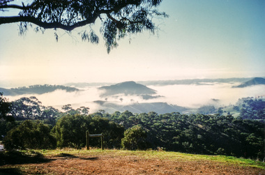
Photograph, Murchison Gap, Autumn Excursion, Hume and Hovell's 1824 expedition, 26 May 1996, 26/05/1996
... grass 4-5 ft. high", dreadful scrub", "devil flies") we took an easier route, saw the Strath Creek memorial in ground fog and a wonderful "field of dreams", the Hume-Hovell privately owned cricket ground with its white picket boundary fence. Now, after a steep climb, in sunshine under gums we stretched and viewed magnificent rolling hills and fog-filled valleys - not "smoke from Aborigines' bush fires". After morning tea at Broadford we followed the Sunday Creek valley beside the Hume Freeway, passed the Wallan Wallan Rest Area...grass 4-5 ft. high", dreadful scrub", "devil flies") we took an easier route, saw the Strath Creek memorial in ground fog and a wonderful "field of dreams", the Hume-Hovell privately owned cricket ground with its white picket boundary fence. Now, after a steep climb, in sunshine under gums we stretched and viewed magnificent rolling hills and fog-filled valleys - not "smoke from Aborigines' bush fires". After morning tea at Broadford we followed the Sunday Creek valley beside the Hume Freeway, passed the Wallan Wallan Rest Area ...[article by Bettina Woodburn in EDHS Newsletter No. 109, July 1996:] ON THE TRAIL OF HUME AND HOVELL - REPORT ON THE AUTUMN EXCURSION - On a green and fresh morning (Sunday 26th May 1996) the Cobb and Co coach (driven by the most obliging Peter Tampion) set off in a north easterly direction from Eltham to connect with Hume and Hovell's route on their 1824 explorations of central Victoria. The Society would follow a series of monuments erected for the 1924 centenary of the expedition from King Parrot Creek (Tuesday 7th December 1824), through Strath Creek, over Sunday Creek (Sunday 12th December 1824) at Broadford, Tullamarine, St Albans, Deer Park, through Werribee, skirting east of the You Yangs to Lara and Avalon Beach. Because their distance-measuring wheel had broken and a one degree mistake was made in calculations, the two leaders of the original group of six convict-companions arrived at Corio Bay, instead of the expected Western Port, discovered earlier by Flinders. From below Mt. Disappointment (Hume and Hovell's difficulties in "scrambling over brush and rock", "leeches in forest, as well as no water", "cutting grass 4-5 ft. high", dreadful scrub", "devil flies") we took an easier route, saw the Strath Creek memorial in ground fog and a wonderful "field of dreams", the Hume-Hovell privately owned cricket ground with its white picket boundary fence. Now, after a steep climb, in sunshine under gums we stretched and viewed magnificent rolling hills and fog-filled valleys - not "smoke from Aborigines' bush fires". After morning tea at Broadford we followed the Sunday Creek valley beside the Hume Freeway, passed the Wallan Wallan Rest Area (more appropriately Hume and Hovell Rest Area) to tum right at Beveridge. In Gellibrand Hill Park, near the headwaters of the Moonee Ponds Creek, we experienced the landscape the first European settlers saw - huge river red gums and rolling pastures. The gardens and sheltered courtyard of the 1840s, timber, brought from .....[?] prefabricated Woodlands Homestead, provided a pleasant lunch stop. We enjoyed a private tour, panoramic views over Melbourne and surroundings and the excitement of arriving and departing aircraft. Our next river crossing was at Werribee, "in a vast treeless plain", then we drove on by-ways no coach had previously travelled, to find "an immense sheet of water" salty Corio Bay, off-course to the west. In late afternoon of a super, calm, late autumn day we headed homewards. Back at Eltham we were rather surprised to find that we had travelled a total of 347 km. Thanks again to Russell Yeoman for his research and organization. What a wonderful day! Three colour photographsactivities, murchison gap, murchison valley -
 Eltham District Historical Society Inc
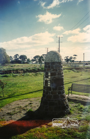
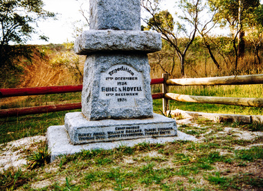
Photograph, Hume and Hovell Monument, Broadford, Autumn Excursion, Hume and Hovell's 1824 expedition, 26 May 1996, 26/05/1996
... grass 4-5 ft. high", dreadful scrub", "devil flies") we took an easier route, saw the Strath Creek memorial in ground fog and a wonderful "field of dreams", the Hume-Hovell privately owned cricket ground with its white picket boundary fence. Now, after a steep climb, in sunshine under gums we stretched and viewed magnificent rolling hills and fog-filled valleys - not "smoke from Aborigines' bush fires". After morning tea at Broadford we followed the Sunday Creek valley beside the Hume Freeway, passed the Wallan Wallan Rest Area...grass 4-5 ft. high", dreadful scrub", "devil flies") we took an easier route, saw the Strath Creek memorial in ground fog and a wonderful "field of dreams", the Hume-Hovell privately owned cricket ground with its white picket boundary fence. Now, after a steep climb, in sunshine under gums we stretched and viewed magnificent rolling hills and fog-filled valleys - not "smoke from Aborigines' bush fires". After morning tea at Broadford we followed the Sunday Creek valley beside the Hume Freeway, passed the Wallan Wallan Rest Area ...[article by Bettina Woodburn in EDHS Newsletter No. 109, July 1996:] ON THE TRAIL OF HUME AND HOVELL - REPORT ON THE AUTUMN EXCURSION - On a green and fresh morning (Sunday 26th May 1996) the Cobb and Co coach (driven by the most obliging Peter Tampion) set off in a north easterly direction from Eltham to connect with Hume and Hovell's route on their 1824 explorations of central Victoria. The Society would follow a series of monuments erected for the 1924 centenary of the expedition from King Parrot Creek (Tuesday 7th December 1824), through Strath Creek, over Sunday Creek (Sunday 12th December 1824) at Broadford, Tullamarine, St Albans, Deer Park, through Werribee, skirting east of the You Yangs to Lara and Avalon Beach. Because their distance-measuring wheel had broken and a one degree mistake was made in calculations, the two leaders of the original group of six convict-companions arrived at Corio Bay, instead of the expected Western Port, discovered earlier by Flinders. From below Mt. Disappointment (Hume and Hovell's difficulties in "scrambling over brush and rock", "leeches in forest, as well as no water", "cutting grass 4-5 ft. high", dreadful scrub", "devil flies") we took an easier route, saw the Strath Creek memorial in ground fog and a wonderful "field of dreams", the Hume-Hovell privately owned cricket ground with its white picket boundary fence. Now, after a steep climb, in sunshine under gums we stretched and viewed magnificent rolling hills and fog-filled valleys - not "smoke from Aborigines' bush fires". After morning tea at Broadford we followed the Sunday Creek valley beside the Hume Freeway, passed the Wallan Wallan Rest Area (more appropriately Hume and Hovell Rest Area) to tum right at Beveridge. In Gellibrand Hill Park, near the headwaters of the Moonee Ponds Creek, we experienced the landscape the first European settlers saw - huge river red gums and rolling pastures. The gardens and sheltered courtyard of the 1840s, timber, brought from .....[?] prefabricated Woodlands Homestead, provided a pleasant lunch stop. We enjoyed a private tour, panoramic views over Melbourne and surroundings and the excitement of arriving and departing aircraft. Our next river crossing was at Werribee, "in a vast treeless plain", then we drove on by-ways no coach had previously travelled, to find "an immense sheet of water" salty Corio Bay, off-course to the west. In late afternoon of a super, calm, late autumn day we headed homewards. Back at Eltham we were rather surprised to find that we had travelled a total of 347 km. Thanks again to Russell Yeoman for his research and organization. What a wonderful day! Colour photographactivities, broadford, hume and hovell, monument -
 Eltham District Historical Society Inc
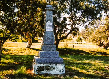
Photograph, Hume and Hovell Monument, Autumn Excursion, Hume and Hovell's 1824 expedition, 26 May 1996, 26/05/1996
... grass 4-5 ft. high", dreadful scrub", "devil flies") we took an easier route, saw the Strath Creek memorial in ground fog and a wonderful "field of dreams", the Hume-Hovell privately owned cricket ground with its white picket boundary fence. Now, after a steep climb, in sunshine under gums we stretched and viewed magnificent rolling hills and fog-filled valleys - not "smoke from Aborigines' bush fires". After morning tea at Broadford we followed the Sunday Creek valley beside the Hume Freeway, passed the Wallan Wallan Rest Area...grass 4-5 ft. high", dreadful scrub", "devil flies") we took an easier route, saw the Strath Creek memorial in ground fog and a wonderful "field of dreams", the Hume-Hovell privately owned cricket ground with its white picket boundary fence. Now, after a steep climb, in sunshine under gums we stretched and viewed magnificent rolling hills and fog-filled valleys - not "smoke from Aborigines' bush fires". After morning tea at Broadford we followed the Sunday Creek valley beside the Hume Freeway, passed the Wallan Wallan Rest Area ...[article by Bettina Woodburn in EDHS Newsletter No. 109, July 1996:] ON THE TRAIL OF HUME AND HOVELL - REPORT ON THE AUTUMN EXCURSION - On a green and fresh morning (Sunday 26th May 1996) the Cobb and Co coach (driven by the most obliging Peter Tampion) set off in a north easterly direction from Eltham to connect with Hume and Hovell's route on their 1824 explorations of central Victoria. The Society would follow a series of monuments erected for the 1924 centenary of the expedition from King Parrot Creek (Tuesday 7th December 1824), through Strath Creek, over Sunday Creek (Sunday 12th December 1824) at Broadford, Tullamarine, St Albans, Deer Park, through Werribee, skirting east of the You Yangs to Lara and Avalon Beach. Because their distance-measuring wheel had broken and a one degree mistake was made in calculations, the two leaders of the original group of six convict-companions arrived at Corio Bay, instead of the expected Western Port, discovered earlier by Flinders. From below Mt. Disappointment (Hume and Hovell's difficulties in "scrambling over brush and rock", "leeches in forest, as well as no water", "cutting grass 4-5 ft. high", dreadful scrub", "devil flies") we took an easier route, saw the Strath Creek memorial in ground fog and a wonderful "field of dreams", the Hume-Hovell privately owned cricket ground with its white picket boundary fence. Now, after a steep climb, in sunshine under gums we stretched and viewed magnificent rolling hills and fog-filled valleys - not "smoke from Aborigines' bush fires". After morning tea at Broadford we followed the Sunday Creek valley beside the Hume Freeway, passed the Wallan Wallan Rest Area (more appropriately Hume and Hovell Rest Area) to tum right at Beveridge. In Gellibrand Hill Park, near the headwaters of the Moonee Ponds Creek, we experienced the landscape the first European settlers saw - huge river red gums and rolling pastures. The gardens and sheltered courtyard of the 1840s, timber, brought from .....[?] prefabricated Woodlands Homestead, provided a pleasant lunch stop. We enjoyed a private tour, panoramic views over Melbourne and surroundings and the excitement of arriving and departing aircraft. Our next river crossing was at Werribee, "in a vast treeless plain", then we drove on by-ways no coach had previously travelled, to find "an immense sheet of water" salty Corio Bay, off-course to the west. In late afternoon of a super, calm, late autumn day we headed homewards. Back at Eltham we were rather surprised to find that we had travelled a total of 347 km. Thanks again to Russell Yeoman for his research and organization. What a wonderful day! Two colour photographsactivities, hume and hovell, monument -
 Eltham District Historical Society Inc
Photograph, Liz Pidgeon, Heritage Excursion; Eltham Lower Park Walk and Talk, 1 July 2017, 1 July 2017
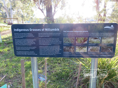
... Plaque explaining "Indigenous grasses of Nillumbik" from the Shire of Nillumbik Newsletter No., 234, June 2017 Heritage Excursion - Saturday 1st July - Eltham Lower Park - Walk and Talk Eltham Lower Park has played an important part in the history of our area since the early days of European settlement when it was used by local residents as an informal racecourse. ...area. The path along the creek and the river provides a pleasant and scenic walk. This walk on Saturday 1st July is about 3.5 km in length and will take 2 to 2.5 hours. It will start at 2pm at the Main Road car park at the front of the park. (Melway ref 21 H 10). heritage excursion activities eltham district historical society eltham lower park information board indigenous grass ...Plaque explaining "Indigenous grasses of Nillumbik" from the Shire of Nillumbik Newsletter No., 234, June 2017 Heritage Excursion - Saturday 1st July - Eltham Lower Park - Walk and Talk Eltham Lower Park has played an important part in the history of our area since the early days of European settlement when it was used by local residents as an informal racecourse. Prior to that its location at the junction of the Diamond Creek and the Yarra River made it an important meeting place for the Wurundjeri people. The park combines formal elements and sporting facilities with remnant bushland that is of environmental significance. It is home to sporting and horse riding clubs, popular play spaces and the Diamond Valley Miniature Railway, which attracts large numbers of visitors. The park will be the venue for our July excursion which will comprise a walk of about 3.5 km around the park and adjacent areas. Along the way we will discuss the history and natural history of the area. The path along the creek and the river provides a pleasant and scenic walk. This walk on Saturday 1st July is about 3.5 km in length and will take 2 to 2.5 hours. It will start at 2pm at the Main Road car park at the front of the park. (Melway ref 21 H 10). Born Digitalheritage excursion, activities, eltham district historical society, eltham lower park, information board, indigenous grass, indigenous plants -
 Eltham District Historical Society Inc
Photograph, Liz Pidgeon, Newly refurbished Eltham Community and Reception Centre, 21 June 2017
... Upgrades to the building include: *replacement of corrugated asbestos roof as a safeguard for users and to prevent flooding *Improved accessibility from the car park to the Centre's entrance *Improved accessibility to the stage area via a lift to the stage level *Water harvesting to capture rainwater for garden and grounds *Installatation of solar power to provide energy and financial savings *Renewal of electrical infrastructure throughout the Centre *Upgrades to lighting and sound controls, replacement of amplifiers and renewal of stage curtains to meet fire standards *New toilets and upgrade to disabled toilet area *New foyer *New kitchen to meet commercial standards. landscaping gardens eltham community and reception centre grass mulch Born Digital Newly refurbished Eltham Community and Reception Centre Photograph Photograph Liz Pidgeon ...Photo taken during an EDHS Excursion "A walk around Little Eltham", 21 June 2017. One of a series of photos. A substantial refurbishment of one of the Shire's most iconic mudbrick buildings took place 2016/2017. JR and BL Kendall Pty Ltf of Hurstbridge undertook the project. Upgrades to the building include: *replacement of corrugated asbestos roof as a safeguard for users and to prevent flooding *Improved accessibility from the car park to the Centre's entrance *Improved accessibility to the stage area via a lift to the stage level *Water harvesting to capture rainwater for garden and grounds *Installatation of solar power to provide energy and financial savings *Renewal of electrical infrastructure throughout the Centre *Upgrades to lighting and sound controls, replacement of amplifiers and renewal of stage curtains to meet fire standards *New toilets and upgrade to disabled toilet area *New foyer *New kitchen to meet commercial standards. Born Digitallandscaping, gardens, eltham community and reception centre, grass, mulch -
 Charlton Golden Grains Museum Inc
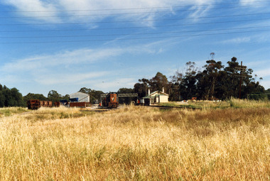
Photograph, Charlton Shire, Charlton Railway Station c. 1987, c.1987
... There is a large area of high grass in the foreground and six electricity wires through the top of the photo....There is a large area of high grass in the foreground and six electricity wires through the top of the photo. ...Charlton Railway Station was established in 1882 and closed down in the late 1970s.Colour photograph of the disused Charlton Railway Station. On the right, there is a small cream and green weatherboard building with a large verandah. There is a train engine and trucks in the middle of the photo and some other trucks to the left. There is a large corrugated iron shed and a small dark grey crane behind it. There is a large area of high grass in the foreground and six electricity wires through the top of the photo.transport, railway station, charlton -
 Otway Districts Historical Society
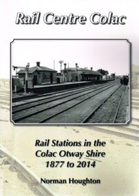
Book, Norman Houghton, Rail Centre Colac, 2014
... The lines traversed agricultural and timber areas where inputs like seed, grass, fertiliser and labour were minor, compared with the output, timber, wool, cream, butter, cheese fruit, potatoes, onion, grain and livestock....The lines traversed agricultural and timber areas where inputs like seed, grass, fertiliser and labour were minor, compared with the output, timber, wool, cream, butter, cheese fruit, potatoes, onion, grain and livestock. colac; cressy; forrest; beech forest; crowes Rail Centre Colac. ...Colac was the centre of a spidery rail network over which were carted anything and everything by Victorian Railways, the common carrier throughout the area. The main line through the region was the 35 km rail route from Birregurra (and thence to Geelong) though Colac to Pirron Yallock (and thence to Warrnambool and Port Fairy) from March, 1877, to July, 1883. The first branch line ran from Irrewarra to Beeac in 1889, which then extended in stages to Cressy and on the Ballarat. The second branch line was the 31 km long Birregurra to Forrest in 1891. The cost of building railways into mountainous terrain meant the third branch line was a narrow-gauge 2 foot 6 inch line, first of all to Beech Forest in 1902, and then to Crowes in 1911, for a total of 71 km. The final rail connection was the 16 km branch from Colac to Alvie to facilitate the transport of onions, opening in 1923. Each line had its own character and peculiarities derived from its foundation, geography and economic base. As a general rule, the loadings on the branch lines had greater output tonnage than inwards, the reverse of the main line. The lines traversed agricultural and timber areas where inputs like seed, grass, fertiliser and labour were minor, compared with the output, timber, wool, cream, butter, cheese fruit, potatoes, onion, grain and livestock.Rail Centre Colac. Rail stations in the Colac Otway Shire, 1877 to 2014. Norman Houghton. 1st ed. Norman Houghton; Geelong (Vic); 2014. vi, 262 p.; illus., maps, index. Soft cover.colac; cressy; forrest; beech forest; crowes -
 Bendigo Historical Society Inc.
Document - PETER ELLIS COLLECTION: NOTES MENTIONING WHIPSTICK REGION
... Four pages of typed notes mentioning the Whipstick Region, Mandurang Forest, Jackass Flat, Diamond Hill Area, One Tree Hill, and the Coliban/Sandhurst Water Supply Reserve. Mentioned are the Birds, Mammals, Geology, Flora, Ground Flora, Orchids,Lilies, Mistletoe, Ferns and Grasses of some of the areas....Region Bendigo Block Bendigo Field Naturalists Club Shipstick Scrub Mandurang Forest One Tree Hill Public park Redvers J Eddy Coliban/Sandhurst Water Supply Reserve Four pages of typed notes mentioning the Whipstick Region, Mandurang Forest, Jackass Flat, Diamond Hill Area, One Tree Hill, and the Coliban/Sandhurst Water Supply Reserve. Mentioned are the Birds, Mammals, Geology, Flora, Ground Flora, Orchids,Lilies, Mistletoe, Ferns and Grasses of some of the areas. ...Four pages of typed notes mentioning the Whipstick Region, Mandurang Forest, Jackass Flat, Diamond Hill Area, One Tree Hill, and the Coliban/Sandhurst Water Supply Reserve. Mentioned are the Birds, Mammals, Geology, Flora, Ground Flora, Orchids,Lilies, Mistletoe, Ferns and Grasses of some of the areas.bendigo, parks and gardens, public reserves, peter ellis collection, north/central l.c.c. region bendigo block, bendigo field naturalists club, shipstick scrub, mandurang forest, one tree hill public park, redvers j eddy, coliban/sandhurst water supply reserve -
 Bendigo Historical Society Inc.
Document - PETER ELLIS COLLECTION: REMARKS ON PROPOSED NATIONAL PARK AREA
... An extra page at the end is titled POACEAE of the Bendigo Area. It lists grasses and reeds with their common names and scientific names....An extra page at the end is titled POACEAE of the Bendigo Area. It lists grasses and reeds with their common names and scientific names. ...Some Introductory Remarks on the Proposed national Park Area in Parishes of Mandurang and Sandhurst printed on white A4 paper. Same as 8626.446 b with two front pages and the bottoms of some pages missing. An extra page at the end is titled POACEAE of the Bendigo Area. It lists grasses and reeds with their common names and scientific names.bendigo, parks and gardens, national parks, peter ellis collection, wild flowers -
 Bendigo Historical Society Inc.
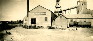
Photograph - NEW RED, WHITE & BLUE CONSOLIDATED MINE - PHOTOS OF THE NEW RED, WHITE & BLUE CONSOLIDATED MINE
... In the foreground are grass and a shrub. There is also an area of sand. On the back is written: New Red White and Blue Consolidated. ...In the foreground are grass and a shrub. There is also an area of sand. On the back is written: New Red White and Blue Consolidated. ...Three black and white photos of the New Red, White & Blue Consolidated Mine. (a) is a small photo of the poppet legs and buildings. There are mullock heaps on the right of the picture. In the foreground are grass and a shrub. There is also an area of sand. On the back is written: New Red White and Blue Consolidated. Originally the Union Shaft. (b) is a photo of the poppet legs and buildings with a large chimney. The overhead tramway is behind the buildings. A man is standing in front of the buildings. There is grass in the foreground. Written on the back: New Red White & Blue Consolidated. Near Dairy Hill Golden Square. (c -) Photo of the buildings, poppet legs and tramway going from the poppet legs to a tall building. The building on the left has a tall chimney. On the front of this building is a sign with the name of the mine on it. In front of the building on the right is a large fuel-type tank with two ladders leaning against it. Written on the back: New Red, White & Blue Consolidated. 2,416 ft.photo, new red, white & blue consolidated mine, photos of the new red, white & blue consolidated mine, union shaft, dairy hill golden square -
 Bendigo Historical Society Inc.
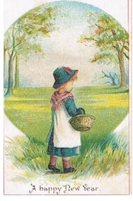
Document - MALONE COLLECTION: GREETING CARDS
... area. In front of this scene is a girl dressed in a blue dress & hat, a white pinafore, pink scarf & socks & brown shoes. She is walking through grass...area. In front of this scene is a girl dressed in a blue dress & hat, a white pinafore, pink scarf & socks & brown shoes. She is walking through grass ...Document. Greeting Cards. Small, single white card with a thin red border infrom the edges. In the border is a circular scene with some trees and a flat grassy area. In front of this scene is a girl dressed in a blue dress & hat, a white pinafore, pink scarf & socks & brown shoes. She is walking through grass. A happy New Yer is printed underneath. On the back is written: To Bessie from her Cousin.person, greeting cards, malone collection, malone collection, greeting cards -
 Flagstaff Hill Maritime Museum and Village
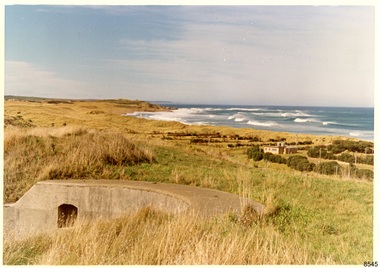
Photograph - Historical, Flagstaff Hill, Warrnambool Garrison Fortifications looking towards the Moyjil (Point Ritchie), 1970s
... area could be between the light-houses (throught the cottage grounds), or a service entrance - past the iron huts used by Lands Department." Coloured photograph, glassy print, one of a set of five. Photograph shows the original site of one of the gun emplacements for the cannons, cannons Historical, looking towards the Moyjil, ,Point Ritchie and overlooking Lady Bay, Warrnambool. The horseshoe shaped concrete gun emplacement is in the foreground on the grassed ...The photograph shows the location of the concrete, horseshoe shaped gun emplacement erected for the cannons. It is part of the Historic Precinct on Flagstaff Hill. The area was accessed either through the space between the Lighthouses (through the cottage grounds) or a service entrance, past the iron huts used by the Lands Department. This photograph, a print, is one of a set of five that show the site of Flagstaff Hill. It is presumed to have been taken by John Lindsay, Founding Director of Flagstaff Hill Maritime Museum and Village. One of the photographs in the set has the pencil inscription "Photo J Lindsay". It was taken in the early 1970s during the initial stages of the development of Flagstaff Hill as a Museum and Maritime Village. The photographs belonged to the donor's grandparents, who lived in the Warrnambool district of Allansford/Naringal. The photograph is a record of the site and surrounds of Flagstaff Hill Maritime Museum and Village before its development and opening in 1975. It shows the east side of the Surfside Holiday Park in its earlier days. The photograph is significant for recording the location and condition of the original concrete cannon emplacement on the Hill.Coloured photograph, glassy print, one of a set of five. Photograph shows the original site of one of the gun emplacements for the cannons, cannons Historical, looking towards the Moyjil, ,Point Ritchie and overlooking Lady Bay, Warrnambool. The horseshoe shaped concrete gun emplacement is in the foreground on the grassed slopes overlooking the Bay. The site and ablution block of the Surfside Holiday Park is centre right. The left shows the sore of Lady Bay with the cliffs of the Southern Ocean in the distance. The photograph's paper has the printer's watermark on the back. The early 1970s scene is presumed to have been photographed by John Lindsay, Warrnambool.Label on the back: "FIRST GUN EMPLACEMENT LOOKING TOWARDS THE HOPKINS / This is the original site of one of the cannons overlooking the Bay. Access to this area could be between the light-houses (throught the cottage grounds), or a service entrance - past the iron huts used by Lands Department."flagstaff hill, flagstaff hill maritime museum and village, warrnambool, maritime museum, maritime village, great ocean road, shipwreck coast, 1970s, photograph, gun emplacement, surfside holiday park, lady bay, hopkins river, flagstaff hill site, john lindsay, concrete gun emplacement, cannon emplacement, original emplacement -
 Ringwood and District Historical Society
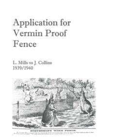
Document - Department of Lands and Survey, Wire Netting Branch, Melbourne, Victoria, Application for Vermin-Proof Fence Certificate - L.J. Mills vs John Collins, Grandview Grove, Ringwood, Victoria - 1939
... Cleared grass land adjoins the south boundary and bush land adjoins the north and west boundaries. I walked over a large area surrounding Mr Mills land and never saw any rabbits or hares or any indications of rabbits. ...Cleared grass land adjoins the south boundary and bush land adjoins the north and west boundaries. I walked over a large area surrounding Mr Mills land and never saw any rabbits or hares or any indications of rabbits. ...Photocopied file of corresponence and documentation relating to a claim by L.J. Mills, Nurseryman, that adjoining property owner, J. Collins, Farmer, assists with replacement of a vermin proof wire netting dividing fence destroyed by 1939 bushfire. File includes 1939 and 1940 detailed property inspection reports by Vermin and Noxious Weeds Branch, Lands Department, Lilydale, describing land use in the area and signs of vermin activity. Application approved 18th April, 1940. Appeal lodged by Mr Collins disallowed in May, 1940. File closed June, 1940 with Departmental suggesion that Mr Mills consider further legal action through a Solicitor as fence had still not been wire-netted. TRANSCRIPTS: Vermin & Noxious Weeds Inspection Reports "19/9/1939 (To) Superintendent (Department of Lands and Survey, Melbourne) Re L.J. Mills application for Vermin Proof Fence. I called on Mr Mills yesterday 18th instant in connection with this matter. Mr Mills has a flower farm and claims that rabbits and hares are damaging his flowers. He showed me a bed of carnations which he stated were being damaged by rabbits. There was evidence of some leaves being nipped off, but I am unable to say whether this is due to rabbits or grubs. Very little if any real damage is being done. The property is netted on the east and south boundary and on half the north and west boundary. The surrounding country is undlating and fairly steep in places. The land to the east across Grandview Avenue (sic) is all planted out in old established orchards and well cultivated. Cleared grass land adjoins the south boundary and bush land adjoins the north and west boundaries. I walked over a large area surrounding Mr Mills land and never saw any rabbits or hares or any indications of rabbits. This locality is not rabbit infested and very little wire netting is being used. I do not consider that a vermin proof fence is necessary between these allotments. - Jas H Allison (Inspector, Vermin and Noxious Weeds Branch, Lands Department, Lilydale)." Follow up report following renewal of application for Certificate by Mr Mills, citing rabbits causing considerable damage to his flowers. He laid poison and obtained 9 carcases and stated that there is evidence of rabbit infestation from the adjoing land. "19/3/1940 (To) Mr Hannah (Superintendant, Department of Lands and Survey, Melbourne) Re L.J. Mills, Grandview Grove Ringwood, Lot 4 Grandview Estate Pt CG20 Ph of Warrandyte. I interviewed Mr Mills at his home on 15th inst. He showed me carcases of rabbits which he stated had been poisoned on his land. In places young plants had been nipped off apparently by rabbits. I made an inspection of adjoining properties and found one live burrow close to Mr Mills northern boundary. There were scratches and other evidence of rabbits on land north and west of Mr Mills property. In view of the present evidence of rabbits I consider that a vermin proof fence is now necessary to protect the flowers grown by Mr Mills. His land is netted on whole of east and south boundary and half way on west and north boundary. The adjoining land on west and north boundaries is owned by Mrs Linda Collins and John Collins resp of Brysons Road East Ringwood. - Jas H Allison (Inspector, Vermin and Noxious Weeds Branch, Lands Department, Lilydale)." -
 Ringwood and District Historical Society
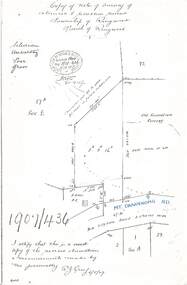
Document - Copy of Lands Department Field Notes - Survey of Extension to Recreation Reserve, Township of Ringwood, Victoria, Field Notes 1907/436 - Part of O.P. R72D Surveyed 6.8.1907
... References include New Lilydale Road 3 chains wide (Mount Dandenong Road), Silurian, undulating, poor grass, Corner cut off to allow for road in future subdivision, Old recreation reserve, (circled area) oval now in use, A. ...References include New Lilydale Road 3 chains wide (Mount Dandenong Road), Silurian, undulating, poor grass, Corner cut off to allow for road in future subdivision, Old recreation reserve, (circled area) oval now in use, A. ...Foolscap size photocopy of survey map with handwritten notations. References include New Lilydale Road 3 chains wide (Mount Dandenong Road), Silurian, undulating, poor grass, Corner cut off to allow for road in future subdivision, Old recreation reserve, (circled area) oval now in use, A. Gisler, I certify that this is a correct copy of the recorded observations & measurements made by me personally (signed) R.J. Gray 6/8/07. -
 Glenelg Shire Council Cultural Collection
Photograph - Photograph - Dutton Way, 1976
... Houses in right background. Large area of spinifex type grass in the foreground, extending to the sea....Houses in right background. Large area of spinifex type grass in the foreground, extending to the sea. ...Port of Portland Authority ArchievesBack: Grey stamp Location - blue biro Dutton Way - pencil Date 30.6.76 - blue biro Time- blue biro Reference 74/10port of portland archives, dutton way -
Glenelg Shire Council Cultural Collection
Photograph - Photograph - Dutton Way, Portland, 1976
... Black & white photo of Dutton Way, looking towards Narrawong. Large area of spinifex type grass....Glenelg Shire Council Cultural Collection History House Cliff Street Portland great-ocean-road Port of Portland Authority Archieves Port of Portland Archives Dutton Way Back: Grey stamp Location - blue biro Dutton Way - pencil Date 30.6.76 - blue biro Time- blue biro Reference 7/14 Black & white photo of Dutton Way, looking towards Narrawong. Large area of spinifex type grass. Photograph Photograph - Dutton Way, Portland ...Port of Portland Authority ArchievesBack: Grey stamp Location - blue biro Dutton Way - pencil Date 30.6.76 - blue biro Time- blue biro Reference 7/14port of portland archives, dutton way -
Glenelg Shire Council Cultural Collection
Photograph - Photograph - Henty Beach, Aug-89
... area (Yacht club end) August '89 V. High tides' - black biro Colour photo of Henty Beach (Yacht Club end) showing cracks in the grass-topped sand bank at water's edge Photograph Photograph - Henty Beach ...Port of Portland Authority ArchivesBack: 'Henty Beach area (Yacht club end) August '89 V. High tides' - black biro -
 Glenelg Shire Council Cultural Collection
Print, Rotunda, 1984
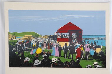
... The work is a photographic screenprint and colour has been added to areas of the photo. In particular, green for the grass, red for the rotunda, blues for the ocean and sky, and various colours for some of the clothing....The work is a photographic screenprint and colour has been added to areas of the photo. In particular, green for the grass, red for the rotunda, blues for the ocean and sky, and various colours for some of the clothing. ...CEMA Art Collection part of "A Community View" 150 years in Portland Screen print Exhibition Part of Angela Gee Residency 1983 and 1984Laminated screenprint of a group of people on Portland's foreshore. People are dressed in late 1800's dress and are watching the rotunda. The work is a photographic screenprint and colour has been added to areas of the photo. In particular, green for the grass, red for the rotunda, blues for the ocean and sky, and various colours for some of the clothing.Front: 34/8 Rotunda (lower left) Lucia Natale 84' (lower right) (pencil) Back: 28 -
 Glenelg Shire Council Cultural Collection
Painting, Jack Freeman, Landscape Dandenong, c. 1961
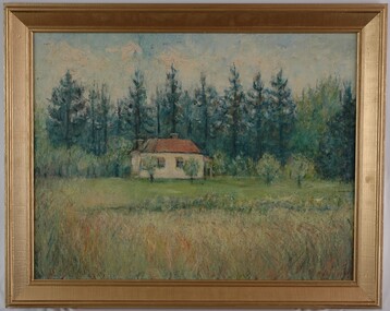
... grasses. The building is situated in the centre of the work and is cream with a red roof and red awnings. In the foreground is a large area of long grass which leads into the shorter maintained grass that surrounds the building. ...grasses. The building is situated in the centre of the work and is cream with a red roof and red awnings. In the foreground is a large area of long grass which leads into the shorter maintained grass that surrounds the building. ...CEMA Art Collection Winner of Portland Artist's Society Prize 1961The painting depicts a small building set amongst tall trees and grasses. The building is situated in the centre of the work and is cream with a red roof and red awnings. In the foreground is a large area of long grass which leads into the shorter maintained grass that surrounds the building. Behind the building are numerous tall dark green trees. The work has a wide gilded frame and exposed canvas.Front: (No inscriptions) Back: Jack Freeman 1961 Landscape Dandenong (top right, black handwriting) 18 (white sticker) -
Glenelg Shire Council Cultural Collection
Photograph - Photograph - LB / TB, n.d
... Lee B'water & reclaimed area under construction, on right. In foreground, pipe from L-R, near shore, then section of grass, with fence between & felled trees along it, then roadway....Lee B'water & reclaimed area under construction, on right. In foreground, pipe from L-R, near shore, then section of grass, with fence between & felled trees along it, then roadway. ...Port of Portland Authority Archivesport of portland archives -
 Flagstaff Hill Maritime Museum and Village
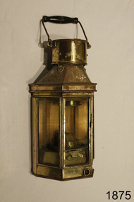
Functional object - Lamp, 1886
... areas around docks and shipyards as well as on vessels. Flagstaff Hill Warrnambool Shipwreck Coast Flagstaff Hill Maritime Museum Maritime Museum Maritime Village Alderson & Gyde Ltd Birmingham Lamp Lantern wall lamp marine equipment maritime light wall light 1886 ship lighting "Alderson & Gyde LTD 1886 Birmingham" Lamp; grass and glass, with flat metal back and three glass windows. ...This late 19th century maritime lamp is an example of lighting on ships, wharfs and other outside areas around docks and shipyards as well as on vessels.Lamp; grass and glass, with flat metal back and three glass windows. Has metal handle and wood hand piece. A brass lug on the back makes provision for attaching to a socket on a wall. The chimney lid flips upwards. The right-side door frame has a sliding latch, and the edge behind has a sliding panel to allow air flow. Made in Birmingham by Alderson & Gyde Limited in 1886."Alderson & Gyde LTD 1886 Birmingham" flagstaff hill, warrnambool, shipwreck coast, flagstaff hill maritime museum, maritime museum, maritime village, alderson & gyde ltd, birmingham, lamp, lantern, wall lamp, marine equipment, maritime light, wall light, 1886, ship lighting -
 Federation University Historical Collection
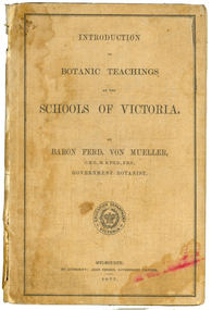
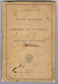
Book, Ferdinand Von Mueller, Introduction to Botanic Teachings at the Schools of Victoria, 1877
... area along the School's northern boundary, fronting Lydiard Street South, and oversaw the establishment of the new Botanical Gardens. Baron von Mueller took a practical role the development of SMB's Botanical Gardens from the beginning. He became a generous benefactor who 'donated collections of seeds and leguminous fodder plants, including valued grasses...area along the School's northern boundary, fronting Lydiard Street South, and oversaw the establishment of the new Botanical Gardens. Baron von Mueller took a practical role the development of SMB's Botanical Gardens from the beginning. He became a generous benefactor who 'donated collections of seeds and leguminous fodder plants, including valued grasses ...Ferdinand von Mueller was an examiner of botany at the Ballarat School of Mines (SMB) between 1880 and 1888. During that era he was active in donating related items to the School. When the Ballarat School of Mines Council agreed to introduce pharmacy and botany classes in 1879, it was apparent students would require access to botanical specimens in order to further their studies. Council members, who were inspired by the work of Baron Ferdinand von Mueller, authorised development of an area along the School's northern boundary, fronting Lydiard Street South, and oversaw the establishment of the new Botanical Gardens. Baron von Mueller took a practical role the development of SMB's Botanical Gardens from the beginning. He became a generous benefactor who 'donated collections of seeds and leguminous fodder plants, including valued grasses of interest and use to agriculturalists and graziers generally' to SMB over many years. Ferdinand von Mueller's entry on the University of Ballarat Honour Roll can be found at http://www.ballarat.edu.au/curator/honour-roll/honourroll_von_mueller.shtml Also See Cat. No. 12062A light brown, hardcovered book of 152 pages. Chapters include Eucalyptus Trees; Wattles or Acacias; Casuarinas or Sheoaks; Cypress Pines or Sandarac trees; Exocarpos trees of Natice Cherry trees; Mistletoes; Native Honeysuckles or Banksias; Bellflower, Lobelia and Goodenia; Heaths; Correas; Mallow; Buttercups and Clematis; Cruciferous Plants; Mints; Orchids; grasses; ferns. The book has numerous botanical line drawings, and a comprehensive index.Inside front cover "Botanist, Teacher, researcher. My you make your mark like the baron. Best wishes for your birthday 1999 Martin"victorian, schools, botany, ferdinand von mueller, von mueller, botanic illustrations, flora, change number -
 Federation University Historical Collection
Book, Ferdinand von Mueller, Introduction to Botanic Teachings at the Schools of Victoria, 1877, 1877 (exact)
... area along the School's northern boundary, fronting Lydiard Street South, and oversaw the establishment of the new Botanical Gardens. Baron von Mueller took a practical role the development of SMB's Botanical Gardens from the beginning. He became a generous benefactor who 'donated collections of seeds and leguminous fodder plants, including valued grasses...area along the School's northern boundary, fronting Lydiard Street South, and oversaw the establishment of the new Botanical Gardens. Baron von Mueller took a practical role the development of SMB's Botanical Gardens from the beginning. He became a generous benefactor who 'donated collections of seeds and leguminous fodder plants, including valued grasses ...Ferdinand von Mueller was an examiner of botany at the Ballarat School of Mines (SMB) between 1880 and 1888. During that era he was active in donating related items to the School. When the Ballarat School of Mines Council agreed to introduce pharmacy and botany classes in 1879, it was apparent students would require access to botanical specimens in order to further their studies. Council members, who were inspired by the work of Baron Ferdinand von Mueller, authorised development of an area along the School's northern boundary, fronting Lydiard Street South, and oversaw the establishment of the new Botanical Gardens. Baron von Mueller took a practical role the development of SMB's Botanical Gardens from the beginning. He became a generous benefactor who 'donated collections of seeds and leguminous fodder plants, including valued grasses of interest and use to agriculturalists and graziers generally' to SMB over many years. Ferdinand von Mueller's entry on the University of Ballarat Honour Roll can be found at http://www.ballarat.edu.au/curator/honour-roll/honourroll_von_mueller.shtml A light brown, hardcovered book of 152 pages. Chapters include Eucalyptus Trees; Wattles or Acacias; Casuarinas or Sheoaks; Cypress Pines or Sandarac trees; Exocarpos trees of Natice Cherry trees; Mistletoes; Native Honeysuckles or Banksias; Bellflower, Lobelia and Goodenia; Heaths; Correas; Mallow; Buttercups and Clematis; Cruciferous Plants; Mints; Orchids; grasses; ferns. The book has numerous botanical line drawings, and a comprehensive index.Inside front cover "J. Clement Souter M.D."victorian, schools, botany, ferdinand von mueller, von mueller, botanic illustrations, j. clement souter -
 Federation University Historical Collection
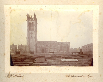
Photograph - Photo, J.W. Mellor, St Michael's and All Angels church and cemetery, Ashton-under-Lyne
... The cemetery area is now covered with grass....The cemetery area is now covered with grass. St Michael's and All Angels church and cemetery, Ashton-under-Lyne Photograph Photo J.W. ...The Church of St Michael and All Angels dates from the 15th century and is the Parish Church for Ashton under Lyne. It is believed there was a church on this site before the Norman Conquest as the Domesday Book mentions a St Michael's Church in the east of the ancient parish of Manchester. Much of the structure was re-constructed in Victorian times. The church with large windows in Perpendicular style. Buttresses were required with this type of building as the large window area reduced the strength of the walls. The church boasts boasts some of the best examples of fifteenth century stained glass left in Britain. There are eighteen panels illustrating the life of St. Helena. The church tower is 145 feet high and has a peel of thirteen bells. (From ashton-under-lyne.com) .1) Sepia photograph mounted onto card showing St Michael's and all Angels church and graveyard in Ashton-Under-Lyne. The gravestones shown in the photograph are no longer evident today. The cemetery area is now covered with grass.cemetery, st michael s and all angels, ashton under lyne, j w mellor, church -
 Federation University Historical Collection
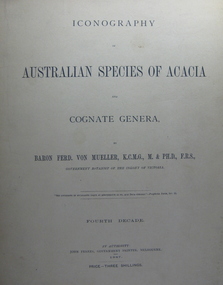
Book, Baron Ferdinand Von Mueller, Iconography of Australian Species of Acacia and Cognate Genera by Ferdinand Von Mueller
... area along the School's northern boundary, fronting Lydiard Street South, and oversaw the establishment of the new Botanical Gardens. Baron von Mueller took a practical role the development of SMB's Botanical Gardens from the beginning. He became a generous benefactor who 'donated collections of seeds and leguminous fodder plants, including valued grasses...area along the School's northern boundary, fronting Lydiard Street South, and oversaw the establishment of the new Botanical Gardens. Baron von Mueller took a practical role the development of SMB's Botanical Gardens from the beginning. He became a generous benefactor who 'donated collections of seeds and leguminous fodder plants, including valued grasses ...Ferdinand von Mueller was an examiner of botany at the Ballarat School of Mines (SMB) between 1880 and 1888. During that era he was active in donating related items to the School. When the Ballarat School of Mines Council agreed to introduce pharmacy and botany classes in 1879, it was apparent students would require access to botanical specimens in order to further their studies. Council members, who were inspired by the work of Baron Ferdinand von Mueller, authorised development of an area along the School's northern boundary, fronting Lydiard Street South, and oversaw the establishment of the new Botanical Gardens. Baron von Mueller took a practical role the development of SMB's Botanical Gardens from the beginning. He became a generous benefactor who 'donated collections of seeds and leguminous fodder plants, including valued grasses of interest and use to agriculturalists and graziers generally' to SMB over many years. Ferdinand von Mueller's entry on the University of Ballarat Honour Roll can be found at http://www.ballarat.edu.au/curator/honour-roll/honourroll_von_mueller.shtml Large format, brown, soft covered books with beautiful line drawings. Set contains 6 of 13 parts, Part 1 covers the fourth decade, Part 2 the fifth decade, Part 3 the eight decade, Part 4 the ninth decade, Part 5 the tenth decade and Part 6 the eleventh decade.botany, ferdinand von mueller, von mueller, botanic illustrations, government botanist, acacia -
 Ballarat Tramway Museum
Photograph - View of Wendouree Parade north end, c1977
... Shows the roadside nature of gardens area at the time - long grass and before the construction of a gutter and paths. ...Shows the roadside nature of gardens area at the time - long grass and before the construction of a gutter and paths. ...Photograph from the window of a tram (possibly No. 28) looking along the BTPS track from St Aidans Drive with another tramcar in the distance. Shows the roadside nature of gardens area at the time - long grass and before the construction of a gutter and paths. Possibly taken at the same time as item 9642.Yields information about Wendouree Parade near St Aidans Drive.Black and white print on Kodak paper.tramcars, trams, btps, tram 26, tram 28, st aidans drive, wendouree parade -
 Sunshine and District Historical Society Incorporated
Photograph - Albion State School 1934 Class Photographs
... The school is set around a courtyard with spacious playing areas including a grassed oval, running track, games courts, an adventure playground, sand pit, jumping pits, shady courtyard and garden areas, a vegetable garden and fruit tree orchard. ...The current school, Albion Primary School, No 4265 opened in 1926. It was built on a site once owned by John Fitzgerald (1850s). The land was later acquired by H. V. McKay who had transferred his Sunshine Harvester Works to the area in 1905 - 7. In 1920, the Albion railway station was moved nearer Ballarat Road at the request of Mr McKay. More people came to live in the area including soldier settlers.Albion Primary School's mission is to 'Aim High' in all we do so that our students grow to be socially capable, reach their full academic potential and become caring, respectful community minded people. Albion Primary School is located in a residential area in Albion, a small pocket of the local government area of Brimbank, approximately 10 kilometres west of Melbourne and was established in 1926. Our current enrolment is 199 students. We have a rich cultural diversity amongst our school community. The school is set around a courtyard with spacious playing areas including a grassed oval, running track, games courts, an adventure playground, sand pit, jumping pits, shady courtyard and garden areas, a vegetable garden and fruit tree orchard. As well as classroom groups, we have our learning teams, student house groups (siblings are allocated to the same house) and a Junior School Council. The school has four main buildings. All classrooms have air conditioning and interactive screens. Block A houses classrooms, staff areas and the administration offices. Our newest building has classrooms and some small group/office spaces. Block B includes our library, canteen and a multi-purpose room used for indoor physical education, Perceptual Motor Program, drama, visiting performers, and community activities. Block C houses classrooms and specialist rooms. We expect and receive the best from our students in terms of their learning and behaviour. The school’s dedicated and effective staff is strongly committed to helping students achieve personal, behavioural, social and academic success. In terms of learning, the highest priority is placed on the work in English and Mathematics. We also have a range of specialist and extra-curricular programs that we provide. Our specialist teacher-librarian is involved in reading extension programs that support development in literacy. All children are able to develop their artistic abilities through visual arts and music program. Our music program is supported by the Australian Children's Music Foundation. A specialist Physical Education teacher provides lessons for all children as well as the opportunity for students to participate in organised lunch time sporting competitions between the house groups. Auslan is the additional language all students learn at Albion. All children participate in a student wellbeing program that focuses on developing strong connections and a sense of belonging within the school. Our school student leaders participate in programs that help develop their leadership skills. 5100.01 - Albion State School 1934 Grade 1 5100.02 - Albion State School 1934 Grade 2 5100.04 - Albion State School 1934 Grade 4 5100.05 - Albion State School 1934 Grade 5 5100.06 - Albion State School 1934 Grade 6 albion state school, albion primary school, adelaide street, albion -
 Sunshine and District Historical Society Incorporated
Photograph - Albion State School 1935 Class Photographs
... The school is set around a courtyard with spacious playing areas including a grassed oval, running track, games courts, an adventure playground, sand pit, jumping pits, shady courtyard and garden areas, a vegetable garden and fruit tree orchard. ...The current school, Albion Primary School, No 4265 opened in 1926. It was built on a site once owned by John Fitzgerald (1850s). The land was later acquired by H. V. McKay who had transferred his Sunshine Harvester Works to the area in 1905 - 7. In 1920, the Albion railway station was moved nearer Ballarat Road at the request of Mr McKay. More people came to live in the area including soldier settlers.Albion Primary School's mission is to 'Aim High' in all we do so that our students grow to be socially capable, reach their full academic potential and become caring, respectful community minded people. Albion Primary School is located in a residential area in Albion, a small pocket of the local government area of Brimbank, approximately 10 kilometres west of Melbourne and was established in 1926. Our current enrolment is 199 students. We have a rich cultural diversity amongst our school community. The school is set around a courtyard with spacious playing areas including a grassed oval, running track, games courts, an adventure playground, sand pit, jumping pits, shady courtyard and garden areas, a vegetable garden and fruit tree orchard. As well as classroom groups, we have our learning teams, student house groups (siblings are allocated to the same house) and a Junior School Council. The school has four main buildings. All classrooms have air conditioning and interactive screens. Block A houses classrooms, staff areas and the administration offices. Our newest building has classrooms and some small group/office spaces. Block B includes our library, canteen and a multi-purpose room used for indoor physical education, Perceptual Motor Program, drama, visiting performers, and community activities. Block C houses classrooms and specialist rooms. We expect and receive the best from our students in terms of their learning and behaviour. The school’s dedicated and effective staff is strongly committed to helping students achieve personal, behavioural, social and academic success. In terms of learning, the highest priority is placed on the work in English and Mathematics. We also have a range of specialist and extra-curricular programs that we provide. Our specialist teacher-librarian is involved in reading extension programs that support development in literacy. All children are able to develop their artistic abilities through visual arts and music program. Our music program is supported by the Australian Children's Music Foundation. A specialist Physical Education teacher provides lessons for all children as well as the opportunity for students to participate in organised lunch time sporting competitions between the house groups. Auslan is the additional language all students learn at Albion. All children participate in a student wellbeing program that focuses on developing strong connections and a sense of belonging within the school. Our school student leaders participate in programs that help develop their leadership skills. 5101.01 - Albion State School 1935 Grade 1 5101.02 - Albion State School 1935 Grade 2 5101.04 - Albion State School 1935 Grade 4 5101.05 - Albion State School 1935 Grade 5 albion state school, albion primary school, adelaide street, albion