Showing 144 items
matching gravel hill
-
 Bendigo Historical Society Inc.
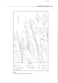
Map - SECTIONS ACROSS BENDIGO GOLDFIELD
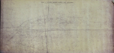
... fault, Hustlers fault, Gravel Hill fault, Ordes fault, Thanet... fault, Gravel Hill fault, Ordes fault, Thanet fault. This map ...Map in three sections showing sections across Bendigo Gold Field, showing anticlines, synclines, faults, stratigraphical zones and mines along the reef lines. Key shows rock types Castlemaine, Bendigo B1, B2, B3 and B4, and Lancefieldian. First part of map shows sections A-A, B-B and C-C. Reef lines drawn with mines listed: Fault line shown are the Carshalton, Stafford, New Chum, Virginia and Clarence. A datum line shows 600 ft above sea level. On bottom of plan: ' Prepared in the Geological Survey Office, Bendigo, under the direction of H. Herman, late Director of Geological Survey, from surveys by H.S. Whitelaw, Field Geologist, assisted by E.S. Usher, A.J.J. Moore and R.A. Keble.' Second section of map shows sections D-D, and E-E. Fault lines listed are the Tambour Major fault, Carshalton fault, Stafford fault, Nell Gwynne fault, New Chum fault, Deborah fault. Third section shows sections F-F and G-G. Fault lines listed are the Bird Reef fault, Kangaroo Gully fault, Langdon fault, Carshalton fault, Nell Gwynne fault, Spring Gully fault, Hustlers fault, Gravel Hill fault, Ordes fault, Thanet fault. This map forms part of the Geological Survey of Victoria, Structure of Bendigo Goldfield report, No. 47, 1923. H.Herman, late Director of Geological Survey.Geological Survey of Victoriabendigo, gold mining, reef line maps -
 Bendigo Historical Society Inc.
Document - CAROL HOLSWORTH COLLECTION: GEOLOGICAL REPORT BENDIGO
... . Third page describes the White Hills gravels. Fourth page... the White Hills gravels. Fourth page is a table showing thel ...Four page document, not sequential. Front page: structural trends, major faults and folds in the Bendigo area are depicted in a diagram. Fault lines and folds include the Leichardt Fault, the Break O'Day Fault, Sebastian Fault, Whitelaw Fault, the Yankee Creek Fault and the Fosterville Fault. Aecond page shows the typical reef forms on the Bendigo goldfield (Willman 1988) in a diagram. The Sebastian goldfield is described, with its four lines of reef, the Eureka, Gaskill's, Frederick the Great and Gamboni. Third page describes the White Hills gravels. Fourth page is a table showing thel biostratigraphic zonation of the Ordovician bedrock based on key graptolite forms and assemblages.bendigo, mining, geological bulletin -
 Federation University Historical Collection
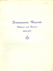
Booklet - Book, Albert Steane, Freemasonic Records Ballarat and District 1854 - 1957, 16/10/1957 (exact)
... , Albert Steane attended the Gravel Hill State School until... the Gravel Hill State School until the fourth class, then transferred ...Born at the Victorian town of Sandhurst (now Bendigo, Albert Steane attended the Gravel Hill State School until the fourth class, then transferred to the Central School 1976 where he gained the Merit Certificate. The monitor system of teacher training had been introduced and he passed as a fourth, third, second and first class pupil teacher. At about 16 years of age Steane was appointed a teacher monitor at £12 per annum. Albert Steane was awarded the Teachers' Certificate of Competency in 1897. He was the first headmaster of the Ballarat Technical School, and opened the Sloyd (woodwork) Centre in 1902 at the Ballarat East Art School (later known as the Ballarat East Free Library). According to the Ballarat Courier of 23 March 1957 Steane established the Ballarat Junior Technical School in February 1913, a part of the School of Mines and Industries Ballarat. The beginning classes with 86 pupils were held at a temporary site at the Dana Street School. Classrooms were so scattered that Steane recalled without his motorbike he would never have covered the ground! By 9 September 1921 the Junior Technical School Building was officially opened on the site of the old Ballarat Gaol. In a confidential report of 1916 Steane was described as one of the best organizers in schools at that time, and he was noted for his strong but fair discipline. In the 1926 school report the Chief Inspector wrote that 'no boy is neglected'. Steane held the position of headmaster at the Ballarat Junior Technical School for 29 years retiring on 16 April 1942. Steane is known for the teaching of Sloyd or woodwork, which was an important point in his career, and for his love of gymnastics. He was made a life member of the Ballarat Y.M.C.A. in 1968 aged 91 years. The teaching of woodwork in Victoria began in 1901 and Steane was chosen, among 18 others for the inaugural training course at Queensberry State School in Melbourne. Because of his lifelong love of gymnastics Steane organized a gymnastic display for the Education Department in 1902 at Bendigo's Golden Jubilee Exhibition. He was one of those instrumental in establishing the Ballarat Y.M.C.A. and directed its physical culture evening classes in 1906. In 1908 Steane toured the world visiting the Swedish Naas Institute and the Gymnastic Festival in Germany. Steane in his reminiscences recalls: "In 1908 I obtained leave of absence and undertook a world trip to further my knowledge of both manual art training and physical training. On this trip I visited U.S.A., Canada, Scotland, England and Europe. Notable events were the attendance at the great 11th Deutche Turnfest at Frankfurt, inspection of the Naas Training School for Sloyd at Naas, Sweden inorgorated [sic] by Otto Solomon, and attendance at Physical Education Demonstrations at London given by the Swedish institution. These P.E. demonstrations were given to assist the organization and introduction of P.E. training in London schools.On returning to Ballarat I resumed my position at the Ballarat East Sloyd Centre and continued my studies at the Ballarat Art School gaining the Drawing Teachers' Certificate." Steane died, aged 93 years, on 13 July 1970, at Sydney, leaving his widow Grace Elliott Steane and children Eric and Violet. Steane is listed on the University of Ballarat Honour Roll at https://www.ballarat.edu.au/curator/honour-roll/honourroll_steane.shtml Printed green book with soft cover. The book lists all masonic bodies, including lodges and chapters, that have worked within 30 miles of Ballarat during the first 100 years of Freemasonry in the district. Includes a Loose, one page addenda et Corrigenda.The image of Albert Steane in the front of the book is inscribed "Yours faithfully A.W. Steane."ballarat, freemason, freemasonic, lodge, albert steane, a a w steane, a j dean, mark lodges, royal ark mariners, royal arch chapters, masonic orders -
 Bendigo Historical Society Inc.
Slide - Dunn's Rock Eppalock, 2012
... Hills Gravel are also found in the area. Another unique... Hills Gravel are also found in the area. Another unique ...The low rolling hills of the Kimbolton countryside consist of ancient, hard and fractured Ordovician rock up to 65 million years old, which was originally deposited deep under the sea. Rocks mainly are sandstone, mudstone, black shale and quartz conglomerates. Marine fossils can be found in the area. Around seven million years ago a basalt flow buried the original bedrock along the along the Campaspe River. Ongoing weathering, wind and water movement over the following years has produced younger clay, sand, silt and gravel deposits throughout the area. Patches of White Hills Gravel are also found in the area. Another unique geological feature of this area is the Permian Glacial Pavement rocks north and south of Eppalock and glacial sediments (such as “Dunn’s Rock” and “Kellams Rock”). During the ice age (up to 280 million years ago) large glaciers moving over the countryside, scoured out sediments, pulverized bedrock, polished and cut grooves into bedrock in the direction of ice movement. When the ice melted boulders etc where left behind in areas of entirely different rock types, such as a 100 Tonne granite block known as ‘The Stranger’ near Derrinal. Dunn's Rock (Glaciated Pavement) Eppalock - Photos of the rock and a field group collecting date with Lake Eppalock (Knowsley) in the backgroundhistory, bendigo, dunn's rock eppalock, kimbolton forest, lake eppalock, gately collection -
 Bendigo Historical Society Inc.
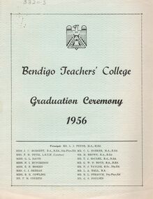
Document - LA TROBE UNIVERSITY BENDIGO COLLECTION: BENDIGO TEACHERS' COLLEGE GRADUATION CEREMONY 1956
... of Gravel Hill State School. Finally the Occasional Address... of Gravel Hill State School. Finally the Occasional Address ...A light blue document titled "Bendigo Teachers' College Graduation Ceremony 1956". Also on the front page is a list of the staff working at the college. On the inside cover is the "Significance of the Ceremony" and the "Order of the Ceremony". A welcome to visitors was given by Mr. F. M. Courtis and the Principal gave the college charge. The signing of the 'Graduation Book' was presented to Mr. A. L. Harris Inspector of Schools, by Miss J. C. Burnett. The final call of the roll for 1956 was given by Mr. C. L. Barker. Congratulations were offered by the Mayor Cr. A .S. Craig and Mr. S. J. Tongway Head Teacher of Gravel Hill State School. Finally the Occasional Address was presented by Mr. J. G. Cannon Chief Inspector of Primary Schools. The next page has a list of the "Students of 1955-56". The back page has the "Principal's Charge". Bolton Bros., Printers, Bendigo. The staff members names are Miss J. C. Burnett, Mrs. F. M. Petri, Miss G. L. Davie, Miss N. L. Hutcheson, Miss E. B. Morris, Mrs C. I. Skehan, Miss B. H. Cowling, Mr. F. M. Courtis, Mr. L. J. Pryor (Principal), Mr. C. L. Barker, Mr. M. Brown, Mr. T. J.McCabe, Mr. G. W. D. Boyd, Mr. N. J. Taylor, Mr. L. A. Hall, Mr. R. L. Strauch and Mr. G. S. Poulsen. The graduating students are - Margaret Carolyn Allinson, Robert Eric Allison, Diane Backhouse, Mary Elizabeth Barbour, Patricia Mary Blake, Peter Brian Cook, Edgar Vincent Crampton, Heather Lorraine Dalrymple, Josephine Margaret Delle Vergini, Roy Stanislaus Dickson, Margaret Isobel Diss, Barry Edwards, Margaret Lorraine Edwards, Edith Dawn Ellis, Graeme Leslie Evans, Dorothea Helen Farrell, Maureen Margaret Forrester, Roma June Hamilton, Carmel Catherine Hart, Esma Olive Haw, Margaret Helen Hogben, Beverley Norwood Hutchinson, Ronald Ireland, Edith Dawn Ireson, Joy Amelia Jeffrey, Valerie Margaret Jones, Noel Charles Kilby, Maxene Shirley King, Dorothy Lorraine Lee, Maxwell John Lovelace, Marie Joan Madin, Margaret Mary Mannes, William Daniel Manson, Janice Renyra Martin, Margaret Dawn Merlo, Anne Mills Moodie, Garry Norman Muller, Janice Nancy McKean, Ronald Walter McKendrick, Norma Maud Neal, Trevor Raymond Oakley, Bruce Peake, Marjorie Peile, Elaine Margaret Plant, Helen Rae Rawiller, Lynette Theresa Reid, Philip William Eric Reid, Geoffrey Rolf Richards, Margaret Rodgers, Anne Marie Sanders, Kenneth Maxwell Sargeant, Pamela Marie Saunders, Jessica Evelyn Scoones, Jean Neilson Shadforth, Beverley Mabel Slade, Nancye Elizabeth Smith, Margaret Eleanor Speers, Elizabeth Stewart, Leon Maurice Thompson, Margaret Gwen Till, Maureen Alma Trimble, George Walter Vincent, John Fairbank Phillip Waddington, Joyce May Walker, Austin Edward Walsh, Anne Elizabeth Warman, Raymond Henry Way, Dorothea Lillian Wearne, Aileen Margaret Weeks, Gordon Raymond Williams, Janice Margaret Wood, Doreen Amelia Worsnop and Marie Ethel Wright.bendigo, education, bendigo teachers' college graduatio, la trobe university bendigo collection, collection, bendigo teachers' college, bendigo, education, teaching, teachers, students, bendigo teachers' college staff, bendigo teachers' college students, tertiary education, teacher training, history, graduation, graduation ceremony, graduates, graduands -
 Bendigo Historical Society Inc.
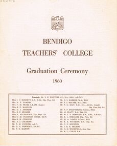
Document - LA TROBE UNIVERSITY BENDIGO COLLECTION: BENDIGO TEACHERS' COLLEGE GRADUATION CEREMONY 1960
... Teacher of Gravel Hill State School. Finally the Occasional... Teacher of Gravel Hill State School. Finally the Occasional ...A cream document titled "Bendigo Teachers' College Graduation Ceremony 1960". The front page also contains a list of the staff working at the college. They are Mr. S. H. Walters (Principal), Miss J. C. Burnett, Mrs. N. F. Fawdry, Mrs. F. M. Petri, Miss R. E. Manlein, Mrs. D. J. Andrew, Mrs. B. F. Hughes, Miss K. Alexander, Miss C. M. Oughton Jones, Miss B. H. Cowling, Mrs. A. J. Coleman, Mr. F. M. Courtis, Mr. D. A. Newbury, Mr. F. X. Martin, Mr. C. L. Barker, Mr. T. J. McCabe, Mr. F. G. East, Mr. P. F. Fitzpatrick, Mr. M. Pratt, Mr. W. J. F. Bernoth, Mr. R. L. Strauch, Mr. M. A. James, Mr. R. E. Wittman, Mr. C. F. Houston, Mr. J. R. R. McLeod, Mr. G. G. Woodfield and Mr. K. C. Coles. The inside cover contains the "Significance of the Ceremony" and "Order of the Ceremony". Mr. F. M. Courtis welcomed the visitors whilst the Principal read the College Charge. The 'Graduation Book' was presented to Mr. A. L. Harris Inspector of Schools by Miss J. C. Burnett.The final roll call for 1960 was read by Mr. C. L. Barker. Congratulations were offered by The Mayor of Bendigo Cr. R. H. Wilson,J. P., Cr. T. A. Drechsler President of Strathfieldsaye Shire and Mr. G. Salathiel, Head Teacher of Gravel Hill State School. Finally the Occasional Address was presented by Mr. F. H. Brooks Assistant Director of Education. The following page contains a list of "Students of 1958-1960 Trained Infant Teacher's Certificate" - Marjorie May Allen, Janice Helen Ashman, Grada Ali Bos, Joan Margaret Busfield, Barbara Joan Cameron, Shirley Margaret Cribbes, Marcia Ann Davison, Margaret Mary Frances Dick, Lorraine Jean MacIntosh Goddard, Beverley Lorraine Goudie, Jennifer Joy Hamilton, Maureen Margaret Hunt, Shirley Joyce Innocent, Monica McKenna, Eileen Bernadette Mulvahil, Nola Ellen Parker, Jeanette Mary Pearson, Maureen Anne Pentland, Elaine Denise Pochon, Marian Judith Rechter, Marilyn Joy Rose, Catherine Shiels, Margaret Evelyn Stevenson, Rosemary Sutherland, Patricia Helen Tassicker, Eileen Monica Tuohey, Robin Elizabeth Walters, Patricia Ann Wenn and Ethel Dawn Whitelock. The back page contains a list of "Students of 1959-1960 Trained Primary Teacher's Certificate". - Kathleen Anne Algie, Ian Armstrong, Lorna Constance Barbour, Ronald Lindsay Bell, Michael Laurence Brown, Ross Ernest Brown, Graeme Lambden Budd, Duncan Leslie Thomas Cameron, Peter Morgan Clutterbuck, Joan Christine Connor, Allen William Cornelius, Glenys Elaine Cussins, Jean Elizabeth Davis, Denis William DeCann, Robert Alain Denham, Janet Carmel Doyle, Patricia May Edwards, Walter Kenneth Espagne, Fay Iris Evans, Brenda Gertrude Farrell, Malcolm George Ferguson, Elizabeth Joyce Fitzgerald, Kevin Joseph Foley, Barbara Violet Forrester, Lawrence Joseph Ginnivan, Peter Murray Graham, Thelma Elaine Grist, Dorothy Robyn Haines, William Jon Hall, Patricia Jeanette Hancock, Robert John Harris, William Ian Hart, Lorraine Moira Holmes, Lynette Ann Ireland, Morris Raymond Jackman, Christine Jackson, Margaret Nancy Jackson, Nanette Elizabeth Johnson, Trevor John Kellam, Robert Bruce Kemp, Ross Eliot Koochew, Henry Francis Lean, Janet Bobbie Leabeter, Rosemary Elizabeth Lowe, Graeme Stanley Lucas, Joy Patricia Maxwell, Terence Michael Mulvihill, George Alan Murdoch, Kevin Michael Murphy, Ann-Marie McCallum, Helen June Nixon, Kerry Joy O'Brien, William John O'Connell, Christine Lynette Olsen, William Stanley Page, Janice Anne Preston, John Stuart Reed, William Francis Reeves, Gary Desmond Robbins, Peter John Schlitz, Donald John McIntosh Shadforth, Gavin James Smith, John Archibald Spark, Illar Streimann, Janice Margaret Taylor, Ian Leonard Thornton, Rosemary Fay Wait, Russell Gilbert Walker, James John Wallis, Clare Mary Ward, David Ross Wiedermann, and Stephen Wilkinson.bendigo, education, bendigo teachers' college graduatio, la trobe university bendigo collection, collection, bendigo teachers' college, bendigo, education, teaching, teachers, students, graduation, tertiary education, graduation ceremony, history, book, bendigo teachers' college staff, graduands, graduates, bendigo teachers' college students, teacher training -
 Bendigo Military Museum
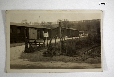
Postcard - POSTCARD - CODFORD AIF CAMP, UK, c1918
Photograph of AIF Codford Camp No. 7. R.H. Baron was stationed here in 1918 during WW1. He later transferred to Herdcott Camp. Part of the Robert H. Baron (No. 3596) and Cooper Collections. See Catalogue No. 1981P for details of Baron's service.Black and white photograph featuring three buildings fronting a gravel road. Two signs appear in the foreground. One is labelled 'No. 7 Camp', the other taller one is labelled 'Salvation Army Rest Hut'. A tree lined hill is in the background.On back, handwritten in black ink: 'Dear Mother, this is the entrance to our camp, the 3rd hut down on the outside is our hut, Robert H. Baron.robert h. baron, cooper collection, postcard, codford aif camp -
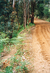
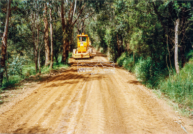
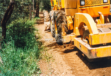
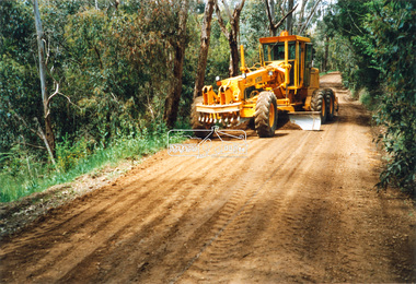
 Eltham District Historical Society Inc
Photograph - Colour Print, Eltham Shire Council, Council oerations road grading and gravel water truck, c.1990
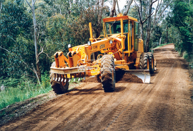
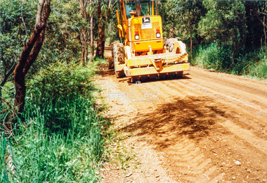
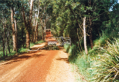
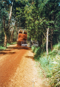
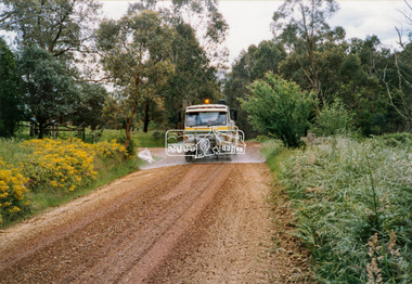
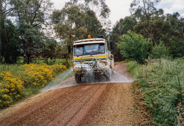
The cost of providing equivalent levels of services to the more rural areas of the Shire with respect to those in the more urban areas of Eltham, Montmorency and Briar Hill was relatively expensive. Road maintenance of rural unsealed gravel roads is one of those areas of higher costs particulary as a result of water erosion. The same applies for Nillumbik Shire Council today. Here we see Council operations grading a road and laying new gravel, followed by a gravel water truck to help bed the surface down. Unfortunately there is no information with these prints as to where this particular location is.graders, infrastructure, road maintenance, roads, shire of eltham, rural road, unidentified -
 Eltham District Historical Society Inc
Photograph - Colour Print, Eltham Shire Council, Council oerations road grading and gravel water truck, c.1990
The cost of providing equivalent levels of services to the more rural areas of the Shire with respect to those in the more urban areas of Eltham, Montmorency and Briar Hill was relatively expensive. Road maintenance of rural unsealed gravel roads is one of those areas of higher costs particulary as a result of water erosion. The same applies for Nillumbik Shire Council today. Here we see Council operations grading a road and laying new gravel, followed by a gravel water truck to help bed the surface down. Unfortunately there is no information with these prints as to where this particular location is.graders, infrastructure, road maintenance, roads, shire of eltham, rural road, unidentified -
 Eltham District Historical Society Inc
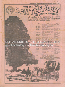
Newspaper - Supplement, Leader Associated Newspapers, Shire of Eltham Centenary; 100 Years of Progress, March 30, 1971
Poduced as a supplement to the Diamond Valley News in celebration of the centenary of the Shire of Eltham in 1971. Contains stories of historical note about people and places of the shire as well as numerous advertisng by local businsesses. Also on page 1 lists the program of events commencing Friday, April 2 commencing with a dinner and previewing of paintings by Justus Jorgensen at Montsalvat attended by the Prime Minister, the Rt. Hon. W. H. McMahon running through to the publication of Pioneers & Painters edited by Alan Marshall. Contents: Page 1 Program of Events Page 2 Wingrove . . man of Eltham Page 3 Council people of 100 years Page 5 Capt. Sweeney, Eltham’s first Irish settler Page 6 Station a tribute to ex-concillor Page 7 Eltham 25 Years Ago just a street Page 9 Kangaroo Ground – once the hub of the shire Page 10 Festival of Arts and Crafts at Montsalvat Page 11 Obelisk honours their memory Page 11 Henry Dendy – an Eltham venture Page 12 Free by rail – if they worked Page 12 The long shadow of Ween Cameron Page 13 McMahon’s – a momentous era Page 14 50 Years Ago . . . Lyon Bros Ford Page 15 Beer at 3d. a pint Page 17 Oldest Home Built in 1850 Page 19 History in black and white . . . . Page 20 Historical Pigeon Bank Page 22 Bridge over log crossing Page 22 Pioneer shot by outlaw Page 23 Milestone for Smith Family Page 24 The Eltham Chamber of Commerce Mardi Gras Advertisers: F.J. & R. Favier (Butcher & Delicatessen Lower Plenty) Eltham Hotel Country Art Store (Eltham) A.R. Warren (Eltham) Heidelberg Travel Service Williams Butcher (Lower Plenty) Greensborough Bulk Store Mac’s Meats (Eltham) Buxton Garden Ornaments (Eltham) Hugh Fisher Photographer (Eltham) Para (Mach. Trading Co. (Greensborough) Westfield Shoppingtown (Doncaster) Clinton’s (Eltham) Gillespie & Lewis P/L (Soft Furnishings Greensborough) T. Hutchinson’s Engineers (Greensborough) Knox & Hellemons Pty Ltd (Builders) Angliss Butchers (Eltham) Rainbow Real Estate (Research) Research Licensed Supermarket Gibsons Research Meat Supply Owen Holmes Motors (Greensborough) Research Pharmacy R. & P. Humphries Delicatessen (Eltham) Montsalvat Eltham Apex Mowerama (Eltham) R.H. Dean & Son Real Estate (Greensborough) L.J. & J.D. Avery Butchers (Eltham) Deylen & Torikov (Motor Engineers Eltham) George Lovitt & Co. Pty Ltd Precision Engineers and Toolmakers Montmorency) Fred’s Mower Repairs (Lower Plenty) Gray’s Milk Bar (Montmorency) Maranne Beauty Salon (Montmorency) Evans Bros. & Newell Pty Ltd (Printing Greensborough) La Ronde Restaurant (Eltham) Terry & Margaret’s Garage (Caltex Lower Plenty) Kevin Dawson Building & Joinery Contractors (Eltham) Montmorency Authorised Newsagency Eltham Produce Store (W.J. Cameron) Consolidated Aluminium (Aust.) Pty Ltd (Eltham) Briar Hill Timber & Trading Co. Pty Ltd Diamond Valley Coaches (Eltham) Lyon Bros Ford (Eltham) The Natural Development Association (Eltham Shire) Alan Whitmore R.E.S.I. (Eltham) Keith Wilkie’s Mensland (Montmorency) Eltham Home Supplies (Eltham) Safeway (Greensborough) Lower Plenty Fish Supply Blue Gum Milk Bar (Eltham) W. Hutchinson Sand Soil & Gravel Suppliers (Greensborough) Keyzers Milk Bar (Greensborough) P.J. Timber & Trading Pty Ltd (Eltham) Diamond Valley Motocycles (Honda Macleod) Neville F. Emerson Real Estate (Lower Plenty) Edon Engineering (Eltham) Mobil Service Centre (Eltham) C.A. & J.M. Kohlman (Panton Hill General Store) C.A. & J.M. Kohlman (Smiths Gully General Store) ANZ (Eltham) Diamond Valley Demolition (Eltham) Volkswagen Specialists (D. Young Greensborough) N.F. Thorpe Pty Ltd Precision Engineers (Briar Hill) Ashley’s Milk Bar (Montmorency) J. Turnbull (General Blacksmith Greensborough) Airlook Service Station (Montmorency) A. & L. Mallios (Grocer Hurstbridge) United Refrigeration Pty Ltd (Greensborough) Peter McDougall & Associates Real Estate (Eltham) Hurstbridge Bus & Taxi Service Pty Ltd Browne Bros. Safeway (Eltham) St Andrews Hotel Eltham Real Estate Pty Ltd Eltham Chamber of Commerce B.P. Evergreen Service Station (Eltham) A.R. Warren Fuel Merchant (Eltham) W. Penna Chemist (Eltham) PPH Produce Paint Hardware (Eltham) Eltham Cake Kitchen (Eltham) Fred Ramak Continental Hairdresser (Eltham) Clinton’s (Eltham) Thompson’s Pharmacy (Eltham) Tillings Timber Supermarket (Eltham) Lyon Bros Ford (Eltham) Bob Clarke’s Men’s Wear (Eltham) Eltham Glen Service Station (Eltham) Miss V. Rampton Naturopath (Eltham) Eltham South Milk Bar (Eltham) Eltham Jewellers (Eltham) Baines Supa-Valu Supermarket (Eltham) Sibbel Builders P/L (Eltham) G. & E. Reivers Fly and Shower Screens (Eltham) Kenton Shoeland (Eltham) Eltham Newsagency (Eltham)One copy marked '1971' on fronta. & l. mallios (grocer hurstbridge), a.r. warren (eltham), a.r. warren fuel merchant (eltham), airlook service station (montmorency), alan whitmore r.e.s.i. (eltham), angliss butchers (eltham), anz (eltham), ashley’s milk bar (montmorency), b.p. evergreen service station (eltham), baines supa-valu supermarket (eltham), blue gum milk bar (eltham), bob clarke’s men’s wear (eltham), briar hill timber & trading co. pty ltd, browne bros. safeway (eltham), buxton garden ornaments (eltham), c.a. & j.m. kohlman (panton hill general store), c.a. & j.m. kohlman (smiths gully general store), clinton’s (eltham), consolidated aluminium (aust.) pty ltd (eltham), country art store (eltham), deylen & torikov (motor engineers eltham), diamond valley coaches (eltham), diamond valley demolition (eltham), diamond valley motocycles (honda macleod), edon engineering (eltham), eltham apex, eltham cake kitchen (eltham), eltham chamber of commerce, eltham glen service station (eltham), eltham home supplies (eltham), eltham hotel, eltham jewellers (eltham), eltham newsagency (eltham), eltham produce store (w.j. cameron), eltham real estate pty ltd, eltham south milk bar (eltham), evans bros. & newell pty ltd (printing greensborough), f.j. & r. favier (butcher & delicatessen lower plenty), fred ramak continental hairdresser (eltham), fred’s mower repairs (lower plenty), g. & e. reivers fly and shower screens (eltham), george lovitt & co. pty ltd precision engineers and toolmakers montmorency), gibsons research meat supply, gillespie & lewis p/l (soft furnishings greensborough), gray’s milk bar (montmorency), greensborough bulk store, heidelberg travel service, hugh fisher photographer (eltham), hurstbridge bus & taxi service pty ltd, j. turnbull (general blacksmith greensborough), keith wilkie’s mensland (montmorency), kenton shoeland (eltham), kevin dawson building & joinery contractors (eltham), keyzers milk bar (greensborough), knox & hellemons pty ltd (builders), l.j. & j.d. avery butchers (eltham), la ronde restaurant (eltham), lower plenty fish supply, lyon bros ford (eltham), mac’s meats (eltham), maranne beauty salon (montmorency), miss v. rampton naturopath (eltham), mobil service centre (eltham), montmorency authorised newsagency, montsalvat, mowerama (eltham), n.f. thorpe pty ltd precision engineers (briar hill), neville f. emerson real estate (lower plenty), owen holmes motors (greensborough), p.j. timber & trading pty ltd (eltham), para (mach. trading co. (greensborough), peter mcdougall & associates real estate (eltham), pph produce paint hardware (eltham), r. & p. humphries delicatessen (eltham), r.h. dean & son real estate (greensborough), rainbow real estate (research), research licensed supermarket, research pharmacy, safeway (greensborough), shire of eltham centenary, sibbel builders p/l (eltham), st andrews hotel, t. hutchinson’s engineers (greensborough), terry & margaret’s garage (caltex lower plenty), the natural development association (eltham shire), thompson’s pharmacy (eltham), tillings timber supermarket (eltham), united refrigeration pty ltd (greensborough), volkswagen specialists (d. young greensborough), w. hutchinson sand soil & gravel suppliers (greensborough), w. penna chemist (eltham), westfield shoppingtown (doncaster), williams butcher (lower plenty), a. roy ford, a.g. thomas, agnes bell, albert h. price, andrew ross, anton w. brinkkotter, arthur brindley, b. bessant, b.w. plant, bell family, charles wingrove, culla hill, dave lyon, david w. bell, e.j. andrew, edwin smith, eltham court house, eltham obelisk, ewen hugh cameron, f.e. griffith, f.v. squire, frank mcmahon, george green, george stebbing, h. eric rundle, harold e. bartlett, henry dendy, henry hurst, henry stooke, herbert a. davies, herbert hewitt, i.g. smedley, j.a. mcdonald, jack baker, jack williams, james k. brice, james rossiter, john lyon, john s. smedley, justus jorgensen, kangaroo ground, larry burke, martin mcmahon, menzies jackson, mott family, mrs andrew, mrs harper, p. harmer, p.j. lester, patrick joseph mcmahon, r.j. galbraith, robert burke, robert charles harris, rosehill, s. willey, shillinglaw cottage, shire of eltham war memorial tower, thomas sweeney, tiny carroll, tom orford, w.b. thomas, william morris -
 Eltham District Historical Society Inc
Film - Video (VHS), Phil Burke et al, Shire of Eltham Grants Commsission Submission (Series 69, Item 7), 1993
Shire of Eltham Archives: Series 69, Item 7 Opens with aerial views of the Shire, 85% of the shire covered by the Green wedge principal. Discusses the obligations required of the Shire to maintain the Green Wedge. The Shire covers over 27,000 hectares with a population in excess of 45,000 residents, more than 70% living in the southern 10% of the Shire in suburbs of Eltham, Montmorency, Lower Plenty and Research. 85% of the Shire in the more sparsely populated northern area which is covered by the Green Wedge. Council is committed to providing a parity of services to all residents such as garbage collection and maintenance of roads. Views of rubbish collection trucks in Montmorency. It is emphasised that the cost of these services in highly populated areas is relatively low whereas in the sparsely populated Green Wedge areas, considerable. There are hundreds of kilometres of roads throughout the Shire, many unmade and maintenance is high to check overhanging trees and erosion especially on the steep hills is expensive and disproportionate to servicing the population in the dense urban areas. Shows views of hilly gravel roads and graders at work maintaining them. Shows scenes of assessing planning applications in these rural areas which takes significantly more time as well as other services provided such as Meals on Wheels, building permits, Ranger services. Provision of recreational facilities in hilly areas requires the acquisition of expensive river flats (views of cricket ground surrounded by hills) and where not possible, costly earthmoving required. Also, views highlighting extensive tracks of natural habitat home to significant bird, animal and plant life. Shire emphasises its commitment highlighted by the Eltham Copper Butterfly which the Shire maintains small pockets of bushland to ensure its survival at significant expense (views of Pauline Toner Copper Butterfly Reserve.) Short interview with Pat Vaughan, Environmental Officer for the Shire discussing the Eltham Copper Butterfly who also mentions many other species in the Shire of high significance from bats to mammals to plants as well as the importance of the Green Wedge to Melbourne – the lungs of Melbourne - and ensuring the protection of very important habitat which requires a great deal of planning and management to look after. Views of Wingrove Park to emphasise this maintenance by machinery in some areas is too damaging and introduced species, etc must be removed by hand. Balancing the services and facilities expected by the community with the needs of the environment requires careful planning demands requires careful planning and the principals of the Green Wedge require constant attention in the face of growing need for housing. Director of Planning & Environment, Richard Allen advises there are approximately 1,300 planning permits and development applications each year ranging from simple subdivision, boundary realignments to further complicated non-urban developments for agricultural pursuits and the level of expertise required from architectural and engineering to land degradation, flora and fauna. Video finishes with aerial views and parklands, streetscapes and rural areas. VHS Video cassette Converted to MP4 file format 00:07:39; 89MBshire of eltham, video recording, shire of eltham archives, eltham shire council, eltham, building permits, cricket ground, development applications, eltham copper butterfly, garbage collection, graders, green wedge, lower plenty, meals on wheels, montmorency, pat vaughan, pauline toner reserve, planning applications, planning permits, ranger services, recreational facilities, research, richard allen, roads, rural areas, wingrove park, victoria grants commission -
 Federation University Historical Collection
Book - Booklet, Seriously History Press et al, The Astonishing History of Ballarat Volume 2: 1856-1883, 2018
Book with greenand white cover.non-fictionballarat, sebastopol hill, lydiard street, powder magazine, deep leads, james oddie, mortality, statistics, shares, stock market, alexander dewar, old gravel pits, koh-i-noor, cobb corner, wesleyan church, henry richards caselli, band of hope mine, sir william don, mine sites -
 Eltham District Historical Society Inc
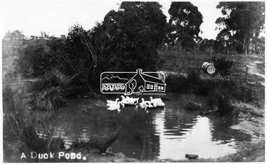
Photograph, Tom Prior, A Duck Pond, c.1900
... at top of hill in Gumtree Road. Gravel from this location... at top of hill in Gumtree Road. Gravel from this location ...The location was Fernie Hill where Ivy Reynolds's mother was born, over from Mr Traill's property at the corner of Reynolds and Main Road, Research - used to be called 3 Chain Road, now renamed Gumtree Road. The old Yarra River bed goes through here at top of hill in Gumtree Road. Gravel from this location was used for the driveways in Government House.This photo forms part of a collection of photographs gathered by the Shire of Eltham for their centenary project book,"Pioneers and Painters: 100 years of the Shire of Eltham" by Alan Marshall (1971). The collection of over 500 images is held in partnership between Eltham District Historical Society and Yarra Plenty Regional Library (Eltham Library) and is now formally known as the 'The Shire of Eltham Pioneers Photograph Collection.' It is significant in being the first community sourced collection representing the places and people of the Shire's first one hundred years.Digital image 4 x 5 inch B&W Negsepp, shire of eltham pioneers photograph collection, eltham, duck pond, reynolds prior collection, pond, fernie hill, gumtree road, research (vic.) -
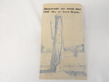 Kiewa Valley Historical Society
Sketch Tree Bark, Aboriginal - bark removed from tree
This sketch of a tree whose bark was cut, by aboriginal craftsmen, to produce a canoe for fishing in the rivers running through the Kiewa Valley either before or just after the 1800's. The tree trunk depicted in the sketch would have been used at the beginning of European settlement in the Kiewa Valley or just before contact was made.As this sketch was of a tree found along the Kiewa River it indicates that Aborigines lived by the river. This sketch depicts the usage of tree bark by the Aboriginal fisher person in crafting a canoe to cross rivers and to fish in the deeper sections of the river course.This freehand sketch detailing the outline of bark removed to provide a canoe is in ink portraying a tree trunk with one branch which has a plaque in front a gravel section to the right and open fields in the mid background and scattered trees on a hill slope in the far background. The sketch is on thick cardboard with a plastic protective cover over it (fastened on the flip side). It is a sketch of the tree now exhibited at the Kiewa Consolidated School.Written in black ink on the top section (heading) "ABORIGINES CUT CANOE FROM TREE. NOW AT KIEWA SCHOOL"crafted canoe, aboriginal craftsmanship, tree usage, early aboriginal craftsmen, kiewa river. kiewa consolidated school -
 Eltham District Historical Society Inc
Photograph, Briar Hill Hall, 1988, 1988
Photograph of gravel car park with cars outside the Briar Hill Hall, 1988. Colour photographBriar Hill Hall 1988briar hill, bob manuell -
 Eltham District Historical Society Inc
Photograph, Entrance to Shire of Eltham Memorial Park, Garden Hill, Eltham-Yarra Glen Road, Kangaroo Ground, c.1923
View to south-east from Shire of Eltham Soldiers' Memorial Park showing the carriageway from the road to top of Memorial Park. Accompanying notes state that the entry gate was put in place in May 1921. Eltham and Whittlesea Shire Advertiser and Diamond Creek Valley Advocate Fri 21 May 1920 p 2 reported: Kangaroo Ground Memorial Park "It was decided to arrange for a working bee on Saturday, 29th inst., for the purpose of forming and gravelling the track leading to the Park, and of carrying out other necessary works." A history summary of the Shire of Eltham Soldiers’ Memorial Park • The summit at Garden Hill was a popular tourist lookout and picnic spot from the 1880s. Virtually the entire Shire of Eltham and beyond could be viewed from this location. • A local farmer, Mr Walter A. D. Wippell is credited as being the first to propose the idea of a war memorial park and offered £50 towards the purchase of the land. • The earliest public reference to this project is to be found in the local Advertiser newspaper edition of August 9th, 1918. A report of the August Council meeting records the Eltham Shire President, Cr. Robert White, saying: "some time back it was proposed that the Council obtain and place on an Honour Board in the Council Chamber [at Kangaroo Ground] containing names of the lads who had enlisted. Just recently however, it had been suggested that a more fitting memorial would be the obtaining of a piece of land on the summit of Garden Hill, Kangaroo Ground, and the formation of a memorial park in which a monument could be erected to represent the whole of Shire. If a couple of acres could be obtained a gentleman had promised to donate 50 pounds, and another one would fence it, and other contributions, he was sure, could be obtained." • Councillors were favourable of the proposal and the President, Shire Secretary and Shire Engineer were deputised to wait on Messrs Mess Bros. (the owners of the Garden Hill farm) and ascertain if they would gratuitously give the land. The Mess Bros. land adjoined the farm/stud of Mrs Fanny White (Cr Robert White’s mother), daughter of Andrew Harkness who established their property on Garden Hill around 1846. • Access to the land came in February 1919 when several Councillors and the Shire Engineer surveyed the actual two acres of '5 chains along the road and 4 chains deep'. The Engineer volunteered his services free to do this task. The Mess brothers however demanded £100 per acre but eventually agreed to take £50 per acre. • Entry from the Kangaroo Ground-Yarra Glen road was seen to be a problem and Mrs. White, who owned the land beside the park, was asked to donated a triangle of her property to allow this access. • By September 1919 returned soldiers were employed by the Shire and volunteers were called to clear the hilltop by ploughing up the rocks and clearing the area, the fencing was put into place and in May 1921 the Council erected three gates, within an archway, at the entrance to the drive and pathway to the summit. • Public subscriptions were sought through the Advertiser newspaper to beautify the site. The views of the Curator of the Melbourne Botanical Gardens were sought as to the ‘class of ornamental trees most suitable for planting in the Park area”. • The Memorial Park or Shire of Eltham Soldiers’ Memorial Park was officially opened by Mr. W.H. Everard, M.L.A., 3 September 1921. • In 1922 plans were made to place a War Memorial in the Park. Funds were donated by the Council of £250 and a challenge to the community, to match this money with contributions was met. • On Anzac Day 1923, 1,000 people gathered on the summit in the park for a memorial service. A much smaller group of about 50 people gathered around a newly constructed cairn and flagstaff in the afternoon of Anzac Day 1924 amidst rain and a squally southerly wind, the morning service being cancelled. • A meeting for those interested in establishing a War Memorial monument within the park was held in January 1924 and the Eltham Shire War Memorial League was formed and a design competition decided upon. • The Shire of Eltham War Memorial tower was built in 1926 at a cost of £1,023 and 5 shillings with locally quarried stone donated by Dr Ethel and Professor William Osborne. It was formally known as the ‘Shire of Eltham War Memorial’ and was unveiled on 11 November 1926. The large bronze inscription above the entrance to the tower states: SHIRE OF ELTHAM WAR MEMORIAL THESE MEN DIED FOR THEIR COUNTRY 1914 IN REMEMBRANCE THIS TOWER WAS BUILT 1918 • The Caretaker’s hut was built in 1927 with left over from the tower construction. • A returned soldier was appointed to act as caretaker for the memorials. Tiny Carrol, a huge man, was the first caretaker and lived in the stone hut. There was a push to have alterations made at one stage to provide additional rooms for a married caretaker but was rejected. • A new Caretaker Cottage was built in 1951 at a cost £2,500. The cottage had been subjected to raids by thieves three times during construction until a guard from the Returned Servicemen’s League was posted until its opening. • The War Memorial tower was re-dedicated by Sir Dallas Brooks on 8 November 1951, unveiling new bronze plaques containing the names of those who fell during the Second World War. Sir Dallas also officiated the opening of the new Caretaker’s Cottage. • A toilet block was built in 1965. • A further dedication of the Shire of Eltham War Memorial tower took place 11 November 2001 to recognise the men who fell in subsequent campaigns up to and including Vietnam. • Four land titles are involved: o The purchase of the two acres from owners Ruth Gosling, Alexander Mess, James Johnson Mess and Joseph Mess is recorded in two actions, the first being the payment of £100 for the two acres, the second showing that the Shire of Eltham did not get a transfer of title until 14th January 1952. o The access land donated by Mrs. Fanny White is dated 26 February 1924. A further need to widen the entry came after the deepening of the road cutting and another land donation was given by Sir Herbert Gepp, title dated 15th May 1952. This would have been about the time he sold off the former White ‘Garden Hill’ property. o The land reserve to increase the area and possibly allow a circuit road to be put in place on the western side of the park was purchased by the Shire of Eltham, title dated 16th February 1973. Rare photograph of the entrance to the Shire's Memorial Park during early stages of development prior to the erection of the Shire of Eltham War MemorialSepia photograph printed with white border with slight crack lower left hand corner and three significant vertical cracks fanning from lower centre edge to upper edge Digitally enhanced version to minimise impact of crackseltham-yarra glen road, entrance gate, garden hill, kangaroo ground, shire of eltham memorial park, shire of eltham war memorial, kangaroo ground war memorial park -
 Orbost & District Historical Society
black and white photographs, late 19th century - early 20th century
3254.1 shows aTculvert over the gully at the foot of Burn’s Hill cutting at Newmerella and has been taken looking up tpward Burn's Cutting at Newmerella .Photograph 3254.2 has been taken from below the cutting. More information in Newsletter, November 2010.These photographs are pictorial records of Burn's Cutting and the old coach road in a time before the establishment of the Orbost to Bairnsdale railway line.Two black / white photographs of a gravel road on the side of a cutting. Both have a coach on the road. burn-road-newmerella cutting-newmerella coach-road-newmerella -
Federation University Historical Collection
Document, Eureka Stockade Site
... Free Trade Hotel Huyghue Stockyard Hill Eureka Lead Gravel Pits ...It is thought this document was produced when determining the site for the replica Stockade on the Eureka Stockade Memorial Gardens. Nine pages of typed information relating to the Site of the Eureka Stockadeeureka, eureka stockade, eureka stockade site, clingin, iain stuart, withers, free trade hotel, huyghue, stockyard hill, eureka lead, gravel pits, m15582 -
 Federation University Historical Collection
Book, Stanley B. Hunter, Memoirs of the Geological Survey of Victoria No 7., The Deep Leads of Victoria, 1909
Pink paper covered book by Stanley Hunter, Engineer in Charge of Boring Operations. Contents include tunnelling, deep sinking, the Chiltern Method, the Ballarat Method, Stawell, Ararat, Moyston, Raglan, Wimmera, Landsborough, Avoca, Ballarat West Leads, Berry-Moolort-Loddon Lead System, Clunes, Creswick, Bullarook Affluent, Corinella, Daylesford-Castlemaine Tributary, Majorca-Carisbrook tributary, Huntly, Coliban, Campaspe, Rutherglen., Smythesdale, Durham Lead, Tanjil, Evolution of Mining Machinery, size of claims, Definition of a Deep Lead, Discovery of Gold in Victoria, Geographical Position of Deep Leads, Water in Deep Leads, Methods of Deep Lead Mining, Cost of Deep Lead Mining, Stawell, Ararat, Moyston, Raglan, Wimmera, Landsborough, Avoca, Ballarat West, Berry, Springs Hill, Loddon Valley, Charlotte Plains, , Timor, Burn Creek, Huntly, Colinan, Goulburn, Ovens Valley, Chiltern, Indigo, Morrison's Lead, Plans include: geological Map of Stawell, ararat, Raglan and Landsborough; Kempson's Freehold Mine, Stawell; Geological Map of Beaufort, Avoca, Maryborough, Ballarat west, Berry-Moolort, Loddon, Creswick, Marong, &c; Cardigan Propriety Gold Mine; Working Miners United Gold Mine, Homebush; Hepburn Deep Lead Plan; Madame Berry West Mine; West Berry Consols Mine; Spring Hill and Central Leads; Berry Consols Extended Mine; Loddon Valley Goldfields; Chalk's No 3 Mine; Charlotte Plains Considated Mine; Duke United Mine; Geological Map of Bendigo, Huntley, Campaspe, Malmsbury, Kyneton, trentham, &c; Geological Map of Chiltern, Rutherglan, Eldorado, Beechworth, &c; Chiltern Valley Gold Mine; Wallace Chiltern Valley Consols Mine; great Southern and Chiltern Valley United Mine; great Northern extended Consols; Prentice and Southern deep Leads; Glenfine South Gold Mine; Geological map of Pitfield, Rokewood, Mt Mercer, Ballark, Meredith, &c.; McEvoy Mine; Dargo . . . . . . . . . . . . . . . . . . . . . . . mining, deep leads, squire, tools, gold panning, gold cradle, cradling, puddling, tubbing, mining shaft, shaft sinking, whip, horse whip, whim, horse whim, chalk's no. 1 mine, maryborough, mining cage, shaft, mining trucks, maryborough, washdirt, puddler, tunnelling, deep sinking, chiltern method of working, ballarat method of working, sampling washdirt. gravels, balmoral, mt william, stawell, moyston, great western, ararat, raglan, wimmera valley, landsborough, cardigan, haddon, beaufort, waterloo, avoca, lamplough, caralulup, ballarat west, ballarat, smythesdale, glenfine, illabarook, durham lead, morrison's lead, bullengarook, berry-moolort-loddon system, clunes, creswick, spring hill, bullarook, castlemaine - daylesford, majorca, carisbrook, timor, burnt creek tributary, tarnagulla, marong, rheola, inglewood, huntly, coliban, campaspe, goulburn lead system, ovens valley system, mitta mitta, kiewa valley, tarago, tanjil, moondarra, bogong, dargo high plains -
 Federation University Historical Collection
Book, Mines Department, Victoria, Deep Leads of Victoria, 1937, 1937
Charcoal green soft covered book of 64 pages. Contents include Ballarat, berry Consols, Canadian Lead, Castlemaine-Daylesford System, Chiltern, Duke of Cornwall Mine, Dyke's Freehold, Frenchman's Lead, Garibaldi Shaft, Glenfine, Guidlford, Hepburn Estate Co., Hepburn Home Paddock, Italian Gully, Henderson's Lead, Langi Logan, Leigh Consols, Sebastopol Plateau; Talbot, Woady Yalloak, A definition of a deep lead, formation of deep leads, water in deep leads, methods of deep lead mining (Tunnelling, Deep sinking, Chiltern method of working, Ballarat method of working), sampling washdirt and gravels, Balmoral, Mt William, Stawell, Moyston, Great Western, Ararat, Raglan, Wimmera Valley, Landsborough, Cardigan, Haddon, Beaufort, Waterloo, Avoca, Lamplough, Caralulup, Ballarat West, Ballarat, Smythesdale, Glenfine, Illabarook, Durham Lead, Morrison's Lead, Bullengarook, Berry-Moolort-Loddon System, Clunes, Creswick, Spring Hill, Bullarook, Castlemaine - Daylesford, Majorca, Carisbrook, Timor, Burnt Creek Tributary, Tarnagulla, Marong, Rheola, Inglewood, Huntly, Coliban, Campaspe, Goulburn Lead System, Ovens Valley System, Mitta Mitts, Kiewa Valley, Tarago, Tanjil, Moondarra, Bogong, Dargo High Plains, glossarymining, deep leads, mines department, squire, leigh consols, chiltern, duke of cornwall mine, dyke's freehold, frenchman's lead, garibaldi shaft, glenfine, guidlford, hepburn estate co., hepburn home paddock, italian gully, henderson's lead, langi logan, sebastopol plateau, talbot, woady yalloak, tunnelling, deep sinking, chiltern method of working, ballarat method of working, sampling washdirt. gravels, balmoral, mt william, stawell, moyston, great western, ararat, raglan, wimmera valley, landsborough, cardigan, haddon, beaufort, waterloo, avoca, lamplough, caralulup, ballarat west, ballarat, smythesdale, illabarook, durham lead, morrison's lead, bullengarook, berry-moolort-loddon system, clunes, creswick, spring hill, bullarook, castlemaine - daylesford, majorca, carisbrook, timor, burnt creek tributary, tarnagulla, marong, rheola, inglewood, huntly, coliban, campaspe, goulburn lead system, ovens valley system, mitta mitta, kiewa valley, tarago, tanjil, moondarra, bogong, dargo high plains -
 Federation University Historical Collection
Plan, Station Reserve Bakery Hill, Ballaarat
.1) Oversized photocopy of large plan depicting railway right of way where Mair and Humffray Streets meet. Main landmarks include Duke of Richmond Hotel, Prince of Wales Hotel, Duke of York Hotel, Welcome Nugget Claim and Shaft, Imperial Hotel, Union Hotel, Kingston St, Otway St, Wellington Claim, Gravel Pits Gold Working and Robert Burns Hotel. .2) Same of above. station reserve, bakery hill, railway, ballarat, mair street, humffray street north, duke of york hotel, duke of richmond hotel, union hotel, kingston st, otway st, wellington claim, gravel pits, gold workings, robert burns hotel