Showing 442 items matching "lands, victoria"
-
 Federation University Historical Collection
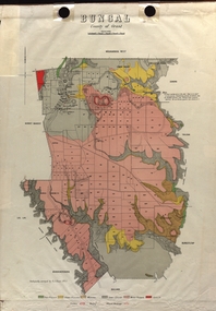
Map - Plan, E.J. Dunn, Bungal County of Grant Parish Plan
E.J. Dunn was the surveyor of this parish plan.Colour geological plan of Bungal in the County of Grant, Victoria. The areas circled in red ar craters.plan, bungal, bungeltap, black horse co. egerton, egerton, mount egerton, sister rose shaft, south learmonth co, kerrit bareet, bungaeeltap, yaloak, eastern moorabool river, corong, bungal station preemptive right, lal lal, western moorabool river, moorabool rover, borhoneychurck, mount egerton battery, bungal creek -
 Marysville & District Historical Society
Map (Item) - Tourist Map, Tourists Resorts' Committee, Tourist's Map of Healesville Marysville and Warburton Districts, 13.10.1925
A tourist map for Healesville, Marysville and Warburton that was produced by the Tourists Resorts' Committee. This map was produced in 1925.A tourist map for Healesville, Marysville and Warburton that was produced by the Tourists Resorts' Committee.Photo Lithographed at the Department of Lands and Survey, Melbourne by W.J. Butson./ 13.10.25healesville, marysville, warburton, victoria, tourists resorts' committee, ben cairn, mount donna buang, the black's spur, the acheron valley, narbethong, launching place, tourist information, tourism, map, tourist map -
 Marysville & District Historical Society
Map (Item) - Tourist Map, Department of Lands & Survey, Tourist's Map of Narbethong and Marysville Districts Victoria, 1913
... by the Department of Lands & Survey in 1925. narbethong marysville victoria ...A tourist map for the Narbethong and Marysville Districts that was originally produced by the Department of Lands & Survey in 1925.A tourist map for the Narbethong and Marysville Districts that was originally produced by the Department of Lands & Survey in 1925.Reprint of the 1925 Tourist brochure by permission R.E. Holmes Surveyor General By Authority: ALBERT J. MULLETT, Government Printer, Melbourne. Photo Lithographed at the Department of Lands and Survey Melbourne by W.J. Butson/ 26.8.13narbethong, marysville, victoria, department of lands & survey, the acheron valley, warburton, map, tourist map -
 Flagstaff Hill Maritime Museum and Village
Document - Map, Department of Lands & Survey, Victoria / Panmure, 1942
This Emergency Edition of the map of Panmure, Victoria, is part of the W.R. Angus Collection. It was printed in 1942 during World War II. It is one of two maps donated to Flagstaff Hill Maritime Village by the family of Doctor William Roy Angus, who served as Surgeon Captain in the Australian Defence Department. The map was compiled for the Dept. of Army by the Dept. of Lands and Survey in Melbourne, prepared by the Australian Section of the Imperial General Staff, which was a British Government body created in 1907 to co-ordinate the defence of Britain and its Empire. It was printed by A.H.Q. Cartographic Company, Survey Corps, which was formed in 1941. The Corp changed its name to L.H.Q. Cartographic Company of Bendigo. In 1947 the name reverted back to the A.H.Q. Cartographic Company until 1955 when it became the A.H.Q. Survey Regiment. The W.R. Angus Collection includes historical medical equipment, surgical instruments and material once belonging to Dr Edward Ryan and Dr Thomas Francis Ryan, (both of Nhill, Victoria) as well as Dr Angus’ own belongings. The Collection’s history spans the medical practices of the two Doctors Ryan, from 1885-1926 plus that of Dr Angus who began practice in 1924. Dr. Angus served with the Australian Department of Defence as a Surgeon Captain during the Second World Was from 1942 to 1945. He served in Ballarat, Victoria, and in Bonegilla, N.S.W. until he suffering from a heart attack just before the war ended. ABOUT THE “W.R.ANGUS COLLECTION” - Doctor William Roy Angus M.B., B.S., Adel., 1923, F.R.C.S. Edin.,1928, was generally known as Dr Roy Angus. His working life included a position as a doctor with the Flying Doctor Service in Australia’s rural and remote areas. After many varied experiences Dr Angus and his family moved to Warrnambool in 1939 where he purchased “Birchwood,” the 1852 home and medical practice of Dr John Hunter Henderson. He was appointed on a part-time basis as Port Medical Officer in Warrnambool and held this position until the 1940’s when the government no longer required the service of a Port Medical Officer. Dr Angus was a surgeon at the Warrnambool Base Hospital 1939-1942. After further studies he commenced practice as an ophthalmologist in Warrnambool, pioneering in artificial eye improvements. He was Honorary Consultant Ophthalmologist to Warrnambool Base Hospital for 31 years and made monthly visits to Portland to perform eye surgery. Dr Angus and his wife Gladys were very involved in Warrnambool’s community with a strong interest in civic affairs. They were both involved in the creation of Flagstaff Hill Maritime Village, including the layout of the gardens. After his death on 28th March 1970 his family requested his practitioner’s plate, medical instruments and some personal belongings be displayed in the Port Medical Office surgery at Flagstaff Hill Maritime Village, and be called the “W. R. Angus Collection”. This Emergency Edition of the Map of Panmure is significant as an example of the documents prepared for the defence of Australia in World War 2. The Map is also significant for its connection between the Australian Army and the involvement of Dr WR Angus as a Surgeon in the Medical Services during World War II. The W.R. Angus Collection is significant for still being located at the site it is connected with, Doctor Angus being the last Port Medical Officer in Warrnambool. The collection of medical instruments and other equipment is culturally significant, being an historical example of medicine, administration, household equipment and clothing from late 19th to mid-20th century. Dr Angus assisted Dr Tom Ryan, a pioneer in the use of X-rays and in ocular surgery. The collection includes Dr Angus’s Army objects and is significant as an example of items issued to Doctors and Surgeons in the Medical Services of the Australian Army in World War IIMilitary map of Panmure, Victoria, Australia; part of the W.R. Angus Collection. Rectangular coloured map on cream paper for the Australian Army. Details include sea, waterways and land, contour lines, grid lines, names of districts, towns and roads, bridges, swamps, rail lines, cuttings, tracks, buildings (including blacksmiths), pumps, lighthouses, telegraph, telephones and electric transmission lines, and fire stations. The map has margin notes that include distances in miles to nearby towns. The map was compiled for the Dept. of Army by the Dept. of Lands and Survey in Melbourne, prepared by the Australian Section, Imperial General Staff and printed by A.H.Q. Cartographic Company, Melbourne in 1942. Crown Copyright Reserved. Inscriptions in red print state that it is and Emergency Edition and an Official document. An oval purple stamp includes the price.Printed in black; 'Victoria / Panmure", "No. 930 / Zone 6" Printed in red; “EMERGENCY EDITION”, “THIS MAP IS AN OFFICIAL DOCUMENT. IF FOUND, IT MUST BE HANDED / IN TO THE NEAREST MILITARY HEADQUARTERS OR POLICE STATION” Stamped: within concentric ovals (“- - - FOR SALE / PRICE 2/- / - - - - - OF THE ARMY”)flagstaff hill, warrnambool, flagstaff hill maritime museum, maritime museum, shipwreck coast, flagstaff hill maritime village, great ocean road, dr w r angus, dr ryan, warrnambool base hospital, flying doctor, surgeon captain, australian department of defence, royal australian army, world war 2, map panmure 1942, roy angus, port medical officer, nhill base hospital, military map, emergency map, military service australian army, department of army, department of lands and survey, a.h.q. cartographic company melbourne, panmure 1942, australian section, imperial general staff -
 Flagstaff Hill Maritime Museum and Village
Document - Map, Department of Lands & Survey, Victoria / Port Campbell, 1942
This Emergency Edition of the map of Port Campbell, Victoria, is part of the W.R. Angus Collection. It was printed in 1942 during World War II. It is one of two maps donated to Flagstaff Hill Maritime Village by the family of Doctor William Roy Angus, who served as Surgeon Captain in the Australian Defence Department. The map was compiled for the Dept. of Army by the Dept. of Lands and Survey in Melbourne, prepared by the Australian Section of the Imperial General Staff, which was a British Government body created in 1907 to co-ordinate the defence of Britain and its Empire. It was printed by A.H.Q. Cartographic Company, Survey Corps, which was formed in 1941. The Corp changed its name to L.H.Q. Cartographic Company of Bendigo. In 1947 the name reverted back to the A.H.Q. Cartographic Company until 1955 when it became the A.H.Q. Survey Regiment. The W.R. Angus Collection includes historical medical equipment, surgical instruments and material once belonging to Dr Edward Ryan and Dr Thomas Francis Ryan, (both of Nhill, Victoria) as well as Dr Angus’ own belongings. The Collection’s history spans the medical practices of the two Doctors Ryan, from 1885-1926 plus that of Dr Angus who began practice in 1924. Dr Angus served with the Australian Department of Defence as a Surgeon Captain during the Second World Was from 1942 to 1945. He served in Ballarat, Victoria, and in Bonegilla, N.S.W. until he suffering from a heart attack just before the war ended. ABOUT THE “W.R.ANGUS COLLECTION” - Doctor William Roy Angus M.B., B.S., Adel., 1923, F.R.C.S. Edin.,1928, was generally known as Dr Roy Angus. His working life included a position as a doctor with the Flying Doctor Service in Australia’s rural and remote areas. After many varied experiences Dr Angus and his family moved to Warrnambool in 1939 where he purchased “Birchwood,” the 1852 home and medical practice of Dr John Hunter Henderson. He was appointed on a part-time basis as Port Medical Officer in Warrnambool and held this position until the 1940’s when the government no longer required the service of a Port Medical Officer. Dr Angus was a surgeon at the Warrnambool Base Hospital 1939-1942. After further studies he commenced practice as an ophthalmologist in Warrnambool, pioneering in artificial eye improvements. He was Honorary Consultant Ophthalmologist to Warrnambool Base Hospital for 31 years and made monthly visits to Portland to perform eye surgery. Dr Angus and his wife Gladys were very involved in Warrnambool’s community with a strong interest in civic affairs. They were both involved in the creation of Flagstaff Hill Maritime Village, including the layout of the gardens. After his death on 28th March 1970 his family requested his practitioner’s plate, medical instruments and some personal belongings be displayed in the Port Medical Office surgery at Flagstaff Hill Maritime Village, and be called the “W. R. Angus Collection”. This Emergency Edition of the Map of Port Campbell is significant as an example of the documents prepared for the defence of Australia in World War 2. The Map is also significant for its connection between the Australian Army and the involvement of Dr WR Angus as a Surgeon in the Medical Services during World War II. The W.R. Angus Collection is significant for still being located at the site it is connected with, Doctor Angus being the last Port Medical Officer in Warrnambool. The collection of medical instruments and other equipment is culturally significant, being an historical example of medicine, administration, household equipment and clothing from late 19th to mid-20th century. Dr Angus assisted Dr Tom Ryan, a pioneer in the use of X-rays and in ocular surgery. The collection includes Dr Angus’s Army objects and is significant as an example of items issued to Doctors and Surgeons in the Medical Services of the Australian Army in World War IIMilitary map of Port Campbell, Victoria, Australia; part of the W.R. Angus Collection. Rectangular coloured map on cream paper for the Australian Army. Details include sea, waterways and land, contour lines, grid lines, names of districts, towns and roads, bridges, swamps, rail lines, cuttings, tracks, buildings (including blacksmiths), pumps, lighthouses, telegraph, telephones and electric transmission lines, and fire stations. The map has margin notes that include distances in miles to nearby towns. The map was compiled for the Dept. of Army by the Dept. of Lands and Survey in Melbourne, prepared by the Australian Section, Imperial General Staff and printed by A.H.Q. Cartographic Company, Melbourne in 1942. Crown Copyright Reserved. Inscriptions in red print state that it is and Emergency Edition and an Official document. An oval purple stamp includes the price.Printed in black; 'Victoria / Port Campbell", "No. 932 / Zone 6" Printed in red; “EMERGENCY EDITION”, “THIS MAP IS AN OFFICIAL DOCUMENT. IF FOUND, IT MUST BE HANDED / IN TO THE NEAREST MILITARY HEADQUARTERS OR POLICE STATION” Stamped: within concentric ovals (“- - - FOR SALE / PRICE 2/- / - - - - - OF THE ARMY”)flagstaff hill, warrnambool, flagstaff hill maritime museum, maritime museum, shipwreck coast, flagstaff hill maritime village, great ocean road, dr w r angus, dr ryan, warrnambool base hospital, nhill base hospital, flying doctor, surgeon captain, map port campbell 1942, roy angus, port medical officer, military map, emergency map, australian department of defence, royal australian army, military service australian army, department of army, department of lands and survey, world war 2, a.h.q. cartographic company melbourne, australian section, imperial general staff, port campbell 1942 -
 Phillip Island and District Historical Society Inc.
Book, MORGAN, Marjorie, Crown lands pre-emptive right applications : Victoria 1850-1854, 1987
Stamped 'Phillip Island & District Historical Society'. Facsim. reprint. First published as: Valuation of Crown Lands under Pre-emptive Right. Melbourne : 1855.land settlement, victoria, history, land subdivision -
Glenelg Shire Council Cultural Collection
Medal, Stokes and Martin, Portland Golden Jubilee Medal, 1884
Medal issued to commemorate the 50th anniversary of Edward Henty's arrival in Portland, Victoria. Edward Henty was born in England in 1809 and migrated to Australia, as did his parents and brothers, in 1829. On 19 November 1834 he sailed from Launceston in the Hentys' own schooner, the Thistle, with stock and a small party. His brother Francis followed the next month with a small flock of merino sheep, the first in Victoria. The Henty brothers began whaling at Portland Bay and took their flocks and herds inland to the rich area on the Wannon River. In the 1840s they were eventually granted pre-emptive rights over most of their lands. Henty was known as a capable and energetic man and regarded as the chief actor in the early history of Portland Bay. He and his wife Anne Marie Gallie moved to Muntham, a 60,000-acre property that became widely known for its merino sheep and Durham cattle. It was also known for its extravagant hospitality - to which Henty's social ambition and vanity contributed considerably. This extravagance and Henty's obstinacy eventually led to the degradation of the flocks. Henty lived in Portland and in his Melbourne mansion, Offington, while he served as a member of the Victoria Legislative Assembly. He died on 14 August 1878Portland Jubilee Medal, 1884. White metal, circular, holed at top as issued. One side features portrait of Edward Henty and text 'HENTY JUBILEE / PORTLAND / 19 NOV 1884' on the other side. -
 Mission to Seafarers Victoria
Film - Documentary, Wind and Sky Productions, Harbour Lights, 2019-2020
Synopsis: “In WW1 Melbourne a pioneering network of women at the Mission to Seafarers called the Ladies Harbour Lights Guild supported sailors who risked their lives at sea. The documentary “Harbour Lights” tells the remarkable story of the Ladies Harbour Lights Guild and the lives of seafarers in early 20th century Melbourne. It focuses on Melbourne’s iconic Mission to Seafarers building, its connection to the Great War and to a unique community of ships crew and volunteers. Featuring Melbourne historians, commentators, archivists and architects and rare footage and images of sailing and social life in and around the ports of Melbourne, this film will inform and connect audiences young and old.” Commissioned by Victorian Government The movie was produced in collaboration with the Mission to Seafarers Victoria. It was directed by Jary Nemo and written and produced by Lucinda Horrocks and Jary Nemo with executive producers Sue Dight and Gordon MacMillan. The film features: Jill Garner Kate Darian-Smith Chris McConville Janet Miller (curator) Gordon MacMillan (former seafarer and board committee member) Narrated by Sharon Turley. Music by Richard Chew (professor of the Arts Academy in Ballarat) The film was presented at several festival in Australia and abroad in 2020-2021. Credits: Narrator Sharon Turley Featuring (in order of appearance) Dr Chris McConville, Gordon MacMillan, Janet Miller, Professor Kate Darian-Smith and Jill Garner With Raul S Gantalao Jr, Escoto Lemuel, Ben Schroeder, Cinda Manins And Ian Fletcher, Yuan Jia, Uma Kothari, Gordon Lansley, William Reed and Cheka Samaranayake Directed by Jary Nemo Written and Produced by Lucinda Horrocks and Jary Nemo Music by Richard Chew Executive Producers Sue Dight and Gordon MacMillan Research advisors Geraldine Brault, Maria Culka, Professor Kate Darian-Smith, Ros Fletcher, Professor Uma Kothari, Dr Barbara Lemon, Catherine McLay, Dr Chris McConville, Janet Miller, Rick Mitchell, Duncan ‘John’ Perryman, Dr Annette Sheill and Peter Taylor Archival photographs, music and footage courtesy of Australian Red Cross Society, Central Highlands Libraries, Internet Archive, National Film and Sound Archive, National Library of Australia, Mackarness Family Personal Archives, Mission to Seafarers Victoria, Public Record Office Victoria, State Library of Victoria and US National Archives Music Harbour Lights. Music by Richard Chew. Westering. Music by Richard Chew. Twilight (Crépuscule) by Jules Massenet. Performed by Amelita Galli-Curci. I Love You So, Waltz from The Merry Widow by Franz Lehár. Performed by Elise Stephenson and Harry Macdonough with Orchestra. Harbour Lights 2. Music by Richard Chew. If I Could Fly by Walking Hearts featuring Jennifer Holm. Courtesy of Epidemic Sound. With thanks to Peter Barrow, Sarah Bartak, Lin Bender AM, Patty Braumueller, Csilla Csongvay, Emer Diviney, Moira Drew, Ian Fletcher, Ajith Jayasuriya, Ben Jones, Patience Jones, Cinda Manins, Madeleine Martiniello, Georgia Melville, Elisabeth Moglia, Tara Oldfield, Lyn Pasquier, Nigel Porteous, Rev’d Onofre (Inni) Punay, Dr Rosalie Triolo, Ben Schroeder, David Simpson, Cheka Samaranayake, Daria Wray, the Helen Macpherson Smith Trust and KPMG. A special thanks to The women of the Ladies Harbour Lights Guild 1906 to 1961 Produced in collaboration with The Mission to Seafarers Victoria Created with the support of The Victorian Government Licensing This film has been released under a Creative Commons BY-NC-ND 4.0 International license Acknowledgement of country Project production and development took place on the lands of the Kulin nation. We acknowledge Traditional Owners and pay our respects to Elders past, present and future. Production company A Wind & Sky Production Copyright with © Wind & Sky Productions MMXIX The film was launched on Wednesday 26th February 2020 at the Mission. Speech by Veterans Affairs. Amongst the guests were current and former volunteers (Maria Culka, Gordon MacMillan, Elisabeth Moglia), curators (Georgia Melville, Jay Miller, Geraldine Brault)18mn documentary mixed of photographs from teh collection and interviews about the Ladies Harbour Lights Guild work during WWIladies harbour lights guild, documentary, jay miller, janet miller, geraldine brault, lucinda horrocks, gordon macmillan, jary nemo, kate darian-smith, jill garner, chris mcconville, sharon turley, richard chew, footage, archive -
![Map, Public Lands Office, Township of Sandridge [cartographic material] / lithographed at the Public Lands Office, March 30th 1859, 30 March 1859](/media/collectors/4f729f5897f83e0308601603/items/63c6354eae7bf372478c58b7/item-media/63c635d4ae7bf372478c7627/item-fit-380x285.jpg) Mission to Seafarers Victoria
Mission to Seafarers VictoriaMap, Public Lands Office, Township of Sandridge [cartographic material] / lithographed at the Public Lands Office, March 30th 1859, 30 March 1859
The map shows where the land of the Customs House was and where the Bethel church was built in 1860. It also shows the name Gregory, a family of land owners who became the managers of the new building on the same site in 1889.sandridge, bethel church, customs house, gregory -
 Greensborough Historical Society
Map, Keelbundora. Counties of Bourke and Evelyn, 1950_11
... Victoria. Department of Lands and Survey... of Bourke and Evelyn Map Victoria. Department of Lands and Survey ...Covers area bounded by Merri Creek, Yarra River, Plenty River and Crown Portions 24 to 28, with section including Maroondah Aqueduct and Darebin Creek.Photocopy of digitised mapkeelbundora (parish) -
 Greensborough Historical Society
Map, Victoria. Department of Crown Lands and Survey, Keelbundoora; Counties of Bourke and Evelyn, 1950c
... Victoria. Department of Crown Lands and Survey...; Counties of Bourke and Evelyn Map Victoria. Department of Crown ...Map of the Victorian counties of Bourke and Evelyn showing parish boundaries and land ownership.Show the original landholders for this area.Map on light brown parchment, covered in plastic."L.5305" and "3462" -
 Greensborough Historical Society
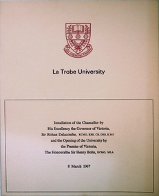
Program, La Trobe University: Installation of Chancellor and opening of the University 1967, 08/03/1967
Installation of Chancellor Sir Archibald Glenn at La Trobe University by Sir Rohan Delacombe, Governor of Victoria. Official opening of La Trobe University in Bundoora on 8th March 1967 by Premier Sir Henry Bolte. Contains background on the development of the university.Celebration of the establishment of the Third University of Victoria. Named after after Charles Joseph La Trobe, Victorias first Lieutenant Governor. It will grow to serve Victoria's North Western Community. The Setting is River Red Gums and grass lands which will be be maintained throughout.Manila coloured card folder with red coloured coat of arms of La Trobe University on cover. Development Plan of university on back cover. (3 copies)la trobe university, bundoora, archibald glenn. -
 Eltham District Historical Society Inc
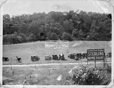
Negative - Photograph, Cricket match, Central Park, Eltham, c.1931
The new Central Park was opened on Monday, 21 April 1930 by Mr. W.H. Everard, M.L.A. followed by a sports carnival. The Advertiser reported on Friday, April 25, 1930 that – “Perfect weather prevailed on Monday for the sports gathering in aid of the recently-acquired park near the railway station, and from every point of view the day was a success. The Central Park contains 9½ acres, and has the Diamond Creek on one side and the railway line on the other. It cost £760, of which the council contributed £500, and the citizens, are finding the balance. Already about £80 has been spent in levelling, and a pavilion has been erected by the footballers, who will use the ground for training until it is sufficiently, improved for matches. There is ample shade along the banks of the creek, where there were numerous picnic parties. The committee has already done some planting on the railway side of the park, and where the trees grow on the higher side, overlooking the arena, the natural stand will have shade, command a view of the events, and have the trees on the banks of the creek in the distance. There were between 600 and 700 people present, many in motor cars having a little difficulty in, finding their way under the aqueduct to the ground, but the council is at present effecting improvements to the road. A merry-go round was a source of pleasure to the children, and the Northcote Soldiers and Citizens Band under Bandmaster Gore, de-lighted everyone with their varied selections of good music.” “Cr. E. J. Andrew, president of the Park Committee, said it was the first function held in the park, and although the citizens have guaranteed £420 towards it, there is still some-thing owing. Mr. W. H. Everard, M.L.A., who can always be relied upon to attend any gathering which draws the people together, said that he and Mrs. Everard had great pleasure in being present to declare the park open. He congratulated the Eltham people upon their public spirit, and the new park would be more appreciated in years to come. The other park is a splendid one, but it is far away, and one is required close to the station, so that young people can have a day's enjoyment, without having to go far from the station. The trouble in Victoria is not having enough parks. The early settlers did a lot in getting park lands, but the present generation is not doing enough. Eltham people are entitled to the highest commendation for their action, and Cr. Andrew and the council are to be thanked for what they have done. What is wanted is ingress and egress so that people can get in comfortably. When he was motoring in his wife said, "Surely you are not going down that precipice," and he replied that he would go anywhere where the people were. In the future it will be the big centre of Eltham.” Reproduced on page 96 of 'Pioneers & Painters'This photo forms part of a collection of photographs gathered by the Shire of Eltham for their centenary project book,"Pioneers and Painters: 100 years of the Shire of Eltham" by Alan Marshall (1971). The collection of over 500 images is held in partnership between Eltham District Historical Society and Yarra Plenty Regional Library (Eltham Library) and is now formally known as the 'The Shire of Eltham Pioneers Photograph Collection.' It is significant in being the first community sourced collection representing the places and people of the Shire's first one hundred years.Digital image 4 x 5 inch B&W Neg 9 x12.5 cm printsepp, shire of eltham pioneers photograph collection, eltham, eltham central park, automobile, central park, cricket match, pioneers and painters -
 Kiewa Valley Historical Society
Photograph of Kiewa Valley Panorama, Farming lands within the Kiewa Valley in1950s, Circa 1950
This photograph shows how (early to mid1900s), before the establishment of the Mount Beauty "gated" village, the Kiewa Valley was farmed and the scarce population was spread out over acres of productive land. This photograph catches a time before (what appeared to the local farmers as the invasion by a mass of construction workers) when this remote valley was part of a "lay back" rural landscape,occasionally visited by friends and some wayward tourists. The mountain ranges provided an adequate barrier against the way-would traveller. The immigration numbers coming into Australia was still quite small ( due to the "white" Australia policy) which was in force before World War II. After World War II a mass of displaced European refugees and migrants boosted the Australian population and provided for a greater degree of diverse professions and rural related work force.This photograph depicts the borderline in time between an exclusively rural based population and respective activities(early 1900s)to the present (2000 on wards) integrated village, tourist and retiree/holiday area. The time when land was exclusively used in agriculture is over and the impact of cheaper rural produce from Asian markets will see a shift of land useage and population activities. The Kiewa Valley is loosing its hiding place and is becoming more and more a source of untapped residential land. Black and white photograph of farming/grazing land useage, before the establishment of the Mount Beauty Village. Small pockets of residentual houses can be viewed. Road access (unsealed dirt) was typical of that provided in rural regions in the 1950s. The photo is on 200gms paper and not on photographic paper.kiewa valley in the early1900s, grazing in the kiewa valley, sec victoria -
 Kiewa Valley Historical Society
Book - Bogong High Plains x2, Early History and Discovery of the Bogong High Plains, 1968
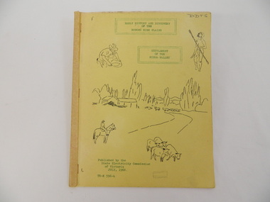
The State Electricity Commission of Victoria constructed the Kiewa Hydro Electric Scheme in the north east of Victoria. Mr R.M. Duncan prepared the notes. He was a member of the S.E.C. Kiewa Branch from 1949 - 1966. This book was commissioned by the State Electricity Commission of Victoria. It consists of the early history of the Bogong High Plains and the origin of names of places and creeks in the area.This book was researched in 1968 by Mr R.M. Duncan who worked for the S.E.C. on the Kiewa Hydro Electric Scheme from 1949 to 1966. His sources were the Melbourne Public Library, the Victorian Historical Society, the North Eastern Victorian Historical Society and the Dept. of Crown Lands & Survey, Melbourne. The book is an accurate history of the Bogong High Plains given the available records at the time. Yellow cardboard covered book with black sketches and green print. 9 one-sided pages held together by 3 staples and taped over the staples. One - has sheets enclosed "The Three Floras of Bogong" and "General Geology of the Kiewa Area". 6 copies including 1 that is a photocopyDDTS hand written on front cover "Early History and Discovery / of the / Bogong High Plains" on cover top centre. "Settlement / of the / Kiewa-Valley" on cover towards the top slightly to the right. "Published by the / State Electricity Commission / of Victoria / July, 1968" on cover bottom left. "TR-K 596-4" on cover bottom left.bogong high plains. state electricity commission of victoria. kiewa. aborigines. kiewa valley. mullindollingong pastoral run. flora. geology -
 Kiewa Valley Historical Society
Book - Book - Alpine Area - Department of Conservation, Forests & Lands, Alpine Area / Planning Proposals / a basis for management. 1987
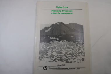
It is the policy of the Government that most of the State's alpine area will be proclaimed as an Alpine National Park, which would complement the Kosciusko National Park in N.S.W.. This is yet to be achieved (1987), however there is a need for sound, efficient and coordinated management based on the area's natural features, values and uses. Planning is proceeding on this basis.Victoria's alpine area is one of the State's most outstanding and spectacular natural areas. It is noted for its diverse plant and animal life, scenery, recreation opportunities and as a water catchment. This country is at the upper end of the Kiewa Valley and the planning for it is of interest to the Kiewa Valley inhabitants.White bound book with green print for title at the top, black & white picture and black print at the bottom for the name of the government authority publishing the book.143 pages with fold out map after page 7. The map is coloured green to indicate the planning area.alpine area, bogong national park, victorian department of conservation forests & lands -
Eltham District Historical Society Inc
Folder, Ewen Cameron
Cameron, Ewen Hugh, M.L.A.., J.P. Kangaroo Ground, is a native of Inverness-shire, Scotland, and came out to Victoria in the ship Hurricane, 13th September, 1853. After he had been engaged for two years int eh building trade in Melbourne in company with is two brothers, since dead, he carried on storekeeping for several years at the Caledonia gold diggings. In 1860 he purchased 80 acres of land at Kangaroo Ground, where he now resides, and later 160 aces of lands at Yarra Flats; he has also 600 acres rented, and is occupied in grazing and agricultural pursuits generally. Mr Cameron holds the prize given by the agricultural society for the best-kept farm in the district. In 1863 he was elected a member of the shire council, and has held the position to represent the Castlemaine mining board, which office he still holds, and in 1874, he was elected to a seat in the Legislative Assembly for the County of Evelyn, which seat he still retains, having the contested the constituency five times, and been elected once without opposition. from "Victoria and its Metropolis: Past and Present" written in 1888 by Alexander Sutherland. Chapter 19, "The Upper Yarra District" pages [402] - 415. Includes descriptions of some townships and short biographies of local residents. Page 405 Folder of information on Ewen Hugh Cameron, MP, Kangaroo Groundewen cameron, pigeon bank -
Eltham District Historical Society Inc
Folder, J.D. and E. Cameron, 1850s
Cameron, Ewen Hugh, M.L.A.., J.P. Kangaroo Ground, is a native of Inverness-shire, Scotland, and came out to Victoria in the ship Hurricane, 13th September, 1853. After he had been engaged for two years int eh building trade in Melbourne in company with is two brothers, since dead, he carried on storekeeping for several years at the Caledonia gold diggings. In 1860 he purchased 80 acres of land at Kangaroo Ground, where he now resides, and later 160 aces of lands at Yarra Flats; he has also 600 acres rented, and is occupied in grazing and agricultural pursuits generally. Mr Cameron holds the prize given by the agricultural society for the best-kept farm in the district. In 1863 he was elected a member of the shire council, and has held the position to represent the Castlemaine mining board, which office he still holds, and in 1874, he was elected to a seat in the Legislative Assembly for the County of Evelyn, which seat he still retains, having the contested the constituency five times, and been elected once without opposition from "Victoria and its Metropolis: Past and Present" written in 1888 by Alexander Sutherland. Chapter 19, "The Upper Yarra District" pages [402] - 415. Includes descriptions of some townships and short biographies of local residents. Page 405 Folder of information on J D and E Cameron, land purchasers, Eltham, c.1850sj.d cameron -
 Orbost & District Historical Society
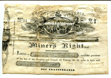
Certificate, September 1867
Following a Royal Commission in 1855, the Gold License was changed to the Miner’s Right, which reduced the fee and required annual payment, rather than monthly or quarterly.The fourth Goldfields Act, passed in early 1858, gave increased privileges to holders of Miner's Rights. These included the right to make residential claims, allowing the cutting of timber on claims and giving the right to build races and dams on any crown lands for mining purposes. This certificate is in the name of Samuel Richardson who brought it to Orbost.This item is of historical significance as it is associated with positive outcomes for gold miners brought about by the Eureka Stockade rebellion and its subsequent democrat changes. It is also associated with the Richardsonfamily who were early settlers in Orbost.A certificate for a miner's right printed on paper. It cost one pound. It was Not Transferable. Details have been filled out in ink. At the top of the licence is an elaborate etching, under the heading 'Colony of Victoria'. Inside a shield is a young woman, crowned, seated, with shipping in the background. oO her left is a miner with hat presenting her with a gold nugget while on her right, a farmer presents grain to her. Mottoes include 'Honi Soit Que Mal Y Pense'; 'Dieu et Mon Droit' and 'Advance Australia' There are handwritten notes in faded ink on the back.miner's right, colony of victoria, samuel richardson, no 14, government act -
 Ringwood and District Historical Society
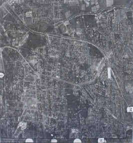
Photograph, Aerial photograph of Heathmont, Victoria - c.1960s, 1975
Aerial view of Heathmont - black and white photograph on chipboard backing. (Protected by slightly damaged plastic cover which could be removed for clearer image.)Department of Crown Lands and Survey Melbourne, Project Run 31A 27-12-1975, Lens 209 1951M ASL. -
 Orbost & District Historical Society
survey sheet, circa 1870's
E.L. Bruce, born in Ireland on July 1,1854, came to Australia in 1854 and joined the Lands Department. He spent most of his service in Gippsland. The journey to Sale then was made by ship to Port Albert and thence on horseback. He began his service in Gippsland as assistant district surveyor and for the last 12 years before retirement he was district surveyor and land officer. His territory extended from the boundary of Victoria in east Gippsland down to Wilson's Promontory with his headquarters at sale.This map is a useful reference tool.A survey map - Sheet No 3 SnowyRiver Survey. This is a copy of the original survey. It shows the properties of W.J.T. Clarke - two in Orbost and one in Newmeralla (sic),. it has a faded, undecipherable red stamp in the bottom right corner.Gipps Land Rivers No 32B E.L. Brucesurvey bruce-e.l snowy-river-c19th -
 Orbost & District Historical Society
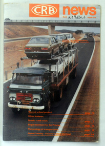
magazine, CRB News, August 1976
By 1910 it had become apparent that there was a need for a central roads authority to take over responsibility from the Board of Lands and Works for the care and management of the main roads of the state of Victoria. Because there was no consistent and systematic policy for road maintenance Victorian roads were in a deplorable condition. At this time the use of the motor car accentuated the demands for better roads. As a result of these needs the Country Roads Act 1912 was proclaimed in 1913 providing for the establishment of the Country Roads Board as a central road authority with responsibility for those roads within the State considered to be main roads. the C.R.B. was responsible for the construction of roads and bridges including the Snowy River road bridges in Orbost. This was a major project involving not only a new bridge over the Snowy River (including Lochiel Lagoon), but other bridges over Ashby’s Gulch and Watt’s Gulch. These new bridges were opened in November 1976 with the unveiling of a plaque on the eastern end of the $2.4M Snowy River Bridge. (ref. May Leatch) This is a useful reference tool on the history of the construction of the Snowy River road bridges.A journal, titled "CRB News" . On the front cover the title is in orange print with No. 33 August 1976 above a coloured photo of a truck carrying two tiers of new vehicles along a main sealed road. It contains information and photos of the construction of the Snowy River road bridges.on front cover - handwritten in black - "M. I. Gilbert"crb-news country-roads-board snowy-river-road-bridges -
 Marysville & District Historical Society
Map (Item) - Tourist Map, Tourists Resorts' Committee, Tourist's Map of Healesville Marysville and Warburton Districts, 13.10.1925
A tourist map for Healesville, Marysville and Warburton that was produced by the Tourists Resorts' Committee. This map was produced in 1925.A tourist map for Healesville, Marysville and Warburton that was produced by the Tourists Resorts' Committee.Photo Lithographed at the Department of Lands and Survey, Melbourne by W.J. Butson./ 13.10.25healesville, marysville, warburton, victoria, tourists resorts' committee, ben cairn, mount donna buang, the black's spur, the acheron valley, narbethong, launching place, tourist information, tourism, map, tourist map -
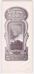 Marysville & District Historical Society
Map (Item) - Tourist Map, Department of Lands & Survey, Tourist's Map of Narbethong and Marysville Districts Victoria, 1913
... by the Department of Lands & Survey in 1925. narbethong marysville victoria ...A tourist map for the Narbethong and Marysville Districts that was originally produced by the Department of Lands & Survey in 1925.A tourist map for the Narbethong and Marysville Districts that was originally produced by the Department of Lands & Survey in 1925.Reprint of the 1925 Tourist brochure by permission R.E. Holmes Surveyor General By Authority: ALBERT J. MULLETT, Government Printer, Melbourne. Photo Lithographed at the Department of Lands and Survey Melbourne by W.J. Butson/ 26.8.13narbethong, marysville, victoria, department of lands & survey, the acheron valley, warburton, map, tourist map -
 Marysville & District Historical Society
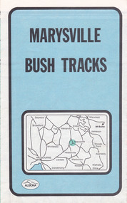
Map (Item) - Bush tracks map, John Siseman et al, MARYSVILLE BUSH TRACKS, 1987
A fold out map of the bush tracks in and around Marysville with information regarding each track. This map was published by Pindari Publications and distributed by Algona Publications. The track notes were compiled by John Siseman in 1987. The map was drawn by Glenn van der Knijff.A fold out map of the bush tracks in and around Marysville with information regarding each track.marysville, victoria, australia, map, bush tracks, pindari publications, algona publications, john siseman, gleen van der knijff, lady talbot forest drive, beauty spot walk, michaeldene track, steavenson falls, tree fern gully walk, trestle track, phantom falls, marysville town walk, marysville lookouts round walk, keppel falls, the beeches round walk, cumberland scenic reserve, cambarville, lake mountain, lake mountain walking track -
Federation University Historical Collection
Document, Zelda Martin, Central Victorian Goldmining towns - Boom Towns or Ghost Towns?, c1996
Zelda Martin was a PhD candidate at the University of Melbourne.[.1] 4th item in light blue display book titled Research Approach/Overview of Chapters/Confirmation of Canditure/Chapters1,2,3&4 of proposed thesis. *Twenty-seven page article on Victorian goldfields towns titled: Central Victorian Goldmining Towns - Boom Towns or Ghost Towns. The article was written during the author's PhD study. It outlines the context methodology, and resources and the chapters of the proposed thesis: (1) Central Victorian Goldmining Towns - The Context (2) Contemporary Views of the Factors Necessary for Town Growth (3) Outward Manifestations of Town Growth (4) The Trappings of Government (5-9) The Main Towns and Their Hinterland. [.2] 5th item in Light Blue display book as above item. *Chapter 1 of proposed thesis titled 'Pick, Shovel and Tin Dish Mining.' Covers in Section A: Central Victoria - Pre 1851: Aborigines in Central Victoria, Squatters, and Government. Section B: The years 1851-1854: The Early Gold Rushes, Government Reaction, Township Surveys, Legislation, Town Development, Local Government and Early Settlement. [.3] 6th item in Light Blue display book as above item. *2A of proposed thesis titled 'Contemporary Views of the Factors Necessary for Town Growth'. Similar information to Chapter 1 plus extra re towns and maps. Sections: Introduction, Context of Place - Geographical Towns Listed, The Context of Time - Pre1851 Aborigines, Governance of Port Phillip, The Squatters, The Villages of Central Victorian Highlands, Conclusion, Condensed Version of Chapter2B. [.4] 7th item in Light Blue display book as above item. *Chapter2B of proposed thesis. Sections: Area of Research, Schools, Banks, Newspapers, Progress Association, Town Development - Sandhurst (Bendigo), Ballarat, Castlemaine,, Maryborough, Ararat and Stawell. [.5] 8th item in Light Blue display book as above item. *Chapter 3 of proposed thesis titled 'Outward Manifestations of Town Growth'. Sections: Introduction, Contemporary Writing, Educationalists, The Bankers, The Townsfolk, Current Theory, General Theories of Urban Development, and Conclusion. [.6] 9th item in Light Blue display book as above item. *Chapter 4 of proposed thesis titled 'Trappings of Government' Sections: Introduction, Early Government Attitudes to Mining and Town Development, Law and Order, Township Surveys, Legislation, Local Government, Transport and Communication, The People and Lobbyists. [.7] 10th item in Light Blue display book as above item. *'The Rise and Fall of Central Victorian Goldmining Towns'. Includes a map showing main Goldfields, a table showing towns and villages at two points in time - 1857 and 1871; a Bibliography of Primary and Secondary Sources. [.8] Resource No1. Black display book titled Local Towns 1 : Alma: *Brief history *Directory *Maps Amphitheatre / Mountain Hut: *Brief History Post Office Directory Ararat: *Brief History *Post Office Directory 1869 - Alphabetical Listing by Occupation *Ararat - Prominent Citizens of 1858 *Langi-Morgala Museum Avoca: *Brief History *Excerpts from 'Avoca The Early Years', Margery and Betty Beavis; pg1 - Beginnings; pg11 - The Midas Touch; pg25 - Local Gold Escorts; pg27 - A Town is Born; pg51- The Administration of Justice; pg53 - The Ways of the Law; pg61 - News of the Day; pg65 - A Time to Play; pg72 - Land Ownership *Post Office Directory (Bailliere's) 1869 *Tourism Map and Information of area *Historic Avoca - A 5.5km Tour *Avoca & the Pyrenees Region - information pamphlet Ballarat: *Early History of Ballarat - Ballarat Historical Society, Publication No.1: origin of the name; Ballaarat - the Beginning; Fabulous Yields from the Ballaarat Goldfield; *Streetscape Lydiard Street. *Hand drawn map showing Leigh River, Old Portland Bay Road, plaque on road to Colac; etc. *Newspaper article re 'The Theatre Royal' ( which stood in the vicinity of the current Owen Williams store) - 'The News'15/04/1998 *Article - 'Ballarat's Mechanics' Institute Lives On' Ballarat Courier, 14/09/1985 *Article - Standing the Test of Time' The News 17/11/1993 re The Mechanics Institute & picture of the Reading Room *'Ballarat a Study of a City, Phyllis Reichl, pub. Nelson, 1968; no.3 place, time and people field studies series *Investigator Vol.33 No.2, 1998 Geelong Historical Society. Article on pg75 describes Ballarat in 1861 *Folded poster - 'Ballarat 100' a history of telegraph communication, pub. Telecom. Beaufort (Fiery Creek): *Brief history *Post Office Directory [.9] Resource No.2 Black Folder Titled Towns cont.No2 Bendigo (Sandhurst): *'Family & Local History at the Bendigo Library - 1851-2001 150 years of gold'. *Bendigo Government Camp in 1853 illustration; key to sketch and names of Government officers stationed there *Excerpts from 'Bendigo and Vicinity' Adolph Haman *The Bendigo Goldfield Registry - pgs 1-7 Introduction *Excerpt: 'Breaking the Grip' *Excerpt: The Most Go-Ahead Place *Excerpts from 'History of Bendigo' - anti license agitation; laying out of town; proposed railway; gold calls and dividends; the Sandhurst Municipality; journalism *Bibliography Blackwood: *Excerpts from 'Aspects of Early Blackwood - The Goldfield, the Landmarks, the Pioneers' Alan J Buckingham and Margaret F Hitchcock, JG Publishing,1980 Buninyong: *A Brief History *Investigator Vol1 No.2 Feb 1966 Geelong Historical Society. Pg3 - Article re gold escort route - Mt Alexander to Adelaide - (see a simple monument on the Western Highway a few miles out of Horsham. Pg 15 - Ballarat Excursion - re the finding of gold. *Three articles published by Buninyong and District Historical Society Inc: (Magpie Exploration; Finding Gold In The Green Hills; Magpie Exploration; Burnt Bridge to Cargarie to Mt Mercer) *Copies of newspaper articles/items *Buninyong Street Directory Carisbrook: *In the Beginning There Was Carisbrook *The History of the Carisbrook Racecourse Carngham / Snake Valley: *Brief History *Directory Castlemaine: *Directory 1865-1866 - Alphabetical and Street *Poster - Castlemaine A Contemporary Guide "The Great Centre" 1866 - A Contemporary Guide to the Fascinating Past *Pamphlet - Castlemaine District Community Hospital *Map - Castlemaine, Maldon & Surrounding Districts *Map and Information - The Dry Diggings Track - a 55kl walk among historic goldfields relics ( Castlemaine Fryerstown Vaughan Mt Franklin Hepburn Daylesford) *Postcard - Former Court House *Directory 1867 - Alphabetical, Trade [.10] Resource No.3 Grey folder Titled Towns 3 Creswick to Maryborough Creswick: *Brief History *Booklet - "Creswick Cemetery Walk" *Booklet - The Buried Rivers of Gold Heritage Trail Creswick *Creswick Historical Museum Information Sheet *Chronological History of Creswick *Alphabetical Directory of the Borough of Creswick *Creswick's Creek Directory 1856 *Historic Creswick Walking Tour *A Brief Account of the Schools of Creswick - Past and Present *100 Years of Railway Travel in Creswick *The Berry Deep Leads *The Spence Home at Jackass Gully in the Creswick State Forest ( William Guthrie Spence - Pioneer) *The New Australian Mine and the 1882 Disaster *Creswick District News, Issue 7, July August 1999 *The Creswick Miners Walk - Information and Map *Maps Chewton: *Brief History *Directory Clunes: *Brief History *Clunes Street Directory Daylesford: *Brief History *Notable Bushfires in Daylesford District Over More Than a Century - "Black Thursday" 1851; 1862; 1899; the Disastrous Hepburn Fire of 1906; 1939; 1944; 1969. *Post Office Directory -Daylesford and Hepburn Dunolly / Inkerman: *Brief History *Directory *Pamphlet - Goldfields Historical Museum *Pamphlet - Historic Dunolly - Victoria's Best Kept Secret *Map of Gold Workings at Dunolly Area - showing where the main gold rushes occurred *Brief History - Inglewood *Directory - Inglewood - Name Occupation, Dwelling Kingower: *Brief History *Directory - Name / Ocupation / Dwelling Linton / Happy Valley / Piggoreet: *Brief History *Directory - Lintons McIvor: *"A History of the Shire and the Township of Heathcote" by J.O. Randell Majorca: *Brief History *Official Post Office Directory 1869 - Name / Occupation/ Address Maldon (Tarrangower): *Brief History Part 1 *Brief History Part 2 *Post Office Directory *List - Alphabetical Order by Names plus Business and Trade (Tarrangower Times Oct/1858) *List - Alphabetical Order by Trade plus Name and Business *Directory - Name / Occupation / Dwelling Maryborough: *Worsley Cottage - built by Arthur Worsley, a contractor in stonework in 1894 [.11] Resource No. 4 Blue Display Book titled Towns 4 Moliagul to Stawell Moliagul: *Brief History *Moligul Legislative Assembly (Voting?) List - Names and Occupations *Moliagul Victorian Post Office Directory 1868 - Name / Ocupation / Address / Comments *"The Welcome Stranger" gold nugget *The Sunday School *The Welcome Stranger Discovery Walk - information and map Moonambel (Mountain Creek) Redbank *Brief History *List of names extracted from advertisments of the Pioneer and Mountain Creek Advertiser 16/02/1861. *Bailliere's Directory 1869 - Alphabetical List of Name / Occupation / Place St Arnaud: *Brief History Sebastapol: *Brief History *Directory 1869 - Alphabetical by Name; plus occupation and address. Browns and Scarsdale: *Brief History *Browns Street Directory - Name and Occupation Smythesdale: *Brief Description *Smythesdale Street Directory -Name and Occupation Stawell (Pleasant Creek) *Brief History *Victorian Official Post Office Directory - Name /Occupation / Dwelling *Chronology - 1841-1920 *Production of gold statistics - 1879 - 1900 *Big Hill *Extracts from "The Golden Years of Stawell". Chapt 1 - Stawell's Coming Out. Capt. 2 - The Gold Rush. Caapt.3 - Cradle of Democracy. Chapt.4 - The Reefs Becomes Stawell. Chapt. 5 - Rushing In. Chapt.6 - The Pioneers. Chapt 7 - The Decade of Optimism. [.12] Resource No. 5: Blue Display Book titled 'Towns Steiglitz to the The Golden Triangle. Steiglitz: Brief History Victorian Post Office Directory 1869 *Map of Steiglitz *List of maps relevant to Steiglitz history *Information 6 tables of data from "Reports of Mining Surveyors Talbot (Back Creek) Brief History Taradale: Post office Directory 1869 - Name/Occupation/Street. Also list in alphabetical order by Occupation Taradale *Chronological Reference to Taradale Mines *Water - The Coliban System of Waterworks *Joseph Brady *The Syphon Tarnagulla (Sandy Creek) *Brief History *Tarnagulla Businessmen Cameos to give depth to advertisments in 'The Tarnagulla Courier' various issues 1864-1871 *Directory - Name/Occupation /Address *List - Name/Business/Trade Wedderburn (Koorong) *Brief History *List - Name/Occupation The Golden Triangle: *The Early Rushes - Wedderburn / Moliagul / Sandy Creek - Tarnagulla / Jones Creek - Waanyarra / Kingower / Dunolly - Goldsborough / Inglweood *Census of 1857 - Population / Occupations *1858-1871 - A Time of Consolidation- Wedderburn / Moliagul / Sandy Creek- Tarnagulla / Arnold *Census 1871 - Population *Information gleaned from the census data - Demographics / Population / Occupations / marital / Birthplace / Religion / Literacy/ Occupation and Housing Cameos *Graphs - Birthplace of settlers /Male-Female Ratio / Married males / Children under 15 as Percentage of Population / Religion *Census 1857 - Statistical data *Maps *Bibliography [.13] Resource No. 6 - Black Display Book Information and Research in Central Victoria including: *Banking - Research from ANZ Bank Archives *Institutions - also includes articles listed from the Ballarat Times Newspaper *Australian mining History Association - A.M.H.A. Bibliography *Australia's Mining History * Bibliography - Land Surveys Victoria - *1853 Administration (Statistics and Other) includes: schools / ministers of religion / police / military / local administration / licences for sale of spirits / distances between various Victorian gold fields. * Victoria Government Gazette (Copy) - N0. 116, 12/12/1854 includes: Gold Felds Commission of Enquiry & No. 85, 15/09/1854 - Addresses presented to the Lieutenant Governor (Sir Charles Hotham) during his tour through the Gold Fields of Victoria,1854. Addresses on behalf of : the people of Bendigo; Members of the Church of England, Bendigo; Members of the Wesleyan Church on the Bendigo Gold Fields; Bendigo Gold District General Hospital; the Bendigo Prospecting Association; Committee of the Bendigo Local Exhibition; Bendigo District Medical Association; Coloured Americans Resident at Bendigo; German Inhabitants of Bendigo; Landowners, Inhabitants, and Miners of Castlemaine; Inhabitants of Forest Creek; Inhabitants of Heathcote and Gold Miners of McIvor; Residents and landholders of the District of Bacchus Marsh; Inhabitants of Kilmore and Vicinity. *Gold Fields Correspondence 1853: letter from Lieutenant Colonel Valiant, (Officer commanding the Troops in Victoria) to the Lieutenant Governor re threatened disturbance at Sandhurst (Bendigo) regarding the Gold License Fee. * Extracts from a book "Victoria" re Gold Fields Commission of Enquiry involving mainly Ballarat and Castlemaine and a chapter titled 'A Tour to the Victorian Gold-Fields' *Lists of central Victorian newspapers - listed by date published 1851to 1874; by first date available to State Library. *A list of cities and towns showing County, population in 1861 &1871, and municipal status. [.14] Resource no.7. Black display book. *Reference: Papers presented to Parliament Victoria - 1859-1860 4 volumes - relevant sections copied. Contains information on Branches of Government. General / Finance / Gold / Gazette / Commission and Warrant / Statistic. *Gold Fields Act. In accordance with the Act the gold fields are divided into six districts - Ballaarat, Castlemaine , Sandhurst, Avoca, Ararat, and Beechworth.. Official staff in each gold district consists of a Resident Warden, Wardens, Wardens' Clerks, Bailiffs, Chinese Protectors, Chinese Interpreters, and Mining Surveyors. *Gold Receiver *Gaols *Police magistrates and Clerks of Petty Sessions, etc. *Field Branch *Immigration and Emigration Overland - Chinese - 1859 *Population on the Goldfields *The Geological Survey - The Government Geologist is assisited by staff from four branches - the office Branch; the Publishing Branch; the Field Branch and the Museum Branch. *Commission to Enquire Into Sludge dated 10/02/1859 (Some sections copied) - Report to the Honorable Chief Commissioner of Public Works, Melbourne re the mode of carrying the sludge from the puddling mills in Sandhurst without interfering with the drainage of the town and the roads in the neighbourhood. [.15] Resource No.8: Camel display book titled Resource No. 8. Aborigines *Lists of book titles - +"Readings in Victorian prehistory" +"The Aborigines of Port Phillip" +Aboriginal languages and clans" +"A History of the Port Phillip District" +"Langi Ghiran 1: Aboriginal Rock...." +"Koorie History: sources for aboriginal studies in the State Library of Victoria", ed. Tom Griffiths, Melb. Friends of the State Library, 1989 +"The Public Lands of Australia Felix"; settlement and land appraisal in Victoria1834-91 with special reference to the Western Plains", J.M.Powell, Melb. Oxford University Press 1970 +*Bibliography of the Victorian Aborigines' from the earliest manuscripts to 31st December 1970, Massoa, Aldo, Melb. Hawthorn Press, 1971 +"Aborigines in Colonial Victoria, 1836-1886", M.F. Christie, Sydney University Press, 1979 +"Urban and Industrial Australia: readings in Human Geography" ed J.M. Powell, Melb. Sorrett Pub. 1974 *Extracts: -Processes of Pioneer Settlement - The Squatting Occupation of Victoria, 1834-60. J.M. Powell -Areal Variations in the Class Structure of the Central-Place Hierarchy. P. Scott - Volume1 and Volume 2: Notes Relating to the Habits of the Natives of Other Parts of Australia and Tasmania. Compiled from various sources for the Government of Victoria by R Brough Smyth. John Curry, O'Neil, Melb. 1st pub. Melb. 1876. p31-45 - Numbers and Distribution of the Aborigines in Victoria -Victorian Aborigines 1835-1901 - A Resource Guide to the Holdings of the Public Record Office, Victoria; published by the Government Information Centre 1984. *History of the Aboriginal Artefacts Displayed in the Daylesford Museum. F. G. Powell (4 page pamphlet) *Letter to Zelda Martin from Peter Lovett, Cultural Officer, Ballarat & District Aboriginal Co- Operative, 05/02/1997 *Map: Ian Clarke Victorian Tribunal Boundary Map - Clans of Central Victoria. *Victorian Rock Art and Mythology - Article about Mount Langhi Ghiran and myths of the Tjapwarong people. *Two Aboriginal myths relating to the Grampians - 'The Monster Emu' / 'The Aquisition of Fire', by the Aborigines in the Grampians Areas *Article titled (chapter 8) Ballarat - information re camping sites in the region. Lake Wendouree / Lake Burrumbeet (includes a myth) / Mt Bunninyong / Lal Lal / Pitfield / Mount Elephant / Mount Egerton / Meredith / Lake Goldsmith / Lake Learmonth / Ercildoune *Notes on the Aborigines of the Wider Ballarat Region plus European names=Aboriginal names. John Morris 26/07/1995 *Role of Aborigines in Town Development in Central Victoria. Mentions Native Police Force est. in Port Phillip 1842 and Central Board for Aborigines est. 1860 *The Grave of King Billy. (Frank Wilson) Pamphlet. *Camping Places in Central and Northern Victoria. Article re Lake Burrumbeet site. *Programme for the Unveiling of Memorial Cairn for Edward Stone Parker 1802-1865. Note portrait not accurate. Accurate portrait is available in the book "A Successful Failure A Trilogy The Aborigines and Early Settlers", Edgar Morrison, Graffiti Publications, 2002. * Large envelope addressed to Mr G Netherway containing newspaper cuttings regarding the life of Edward Stone Parker, the unveiling of the Memorial Cairn as mentioned above, articles titled 'Episodes from Our Early Days' (Edgar Morrison, Yandoit)- The Black's School, A School At Last and The Final years. Also a typed page titled 'Historical Background to E.S.Parker's Career. Includes an interesting tale titled 'When the cat lay doggo' re laying power leads for the unveiling ceremony at the memorial site. [.16] green display folder titled 'Research Aids' *List of references to Commissioners' & W'ardens' Reports (formerly held at La Trobe Library Archives, now at Public Records Office [PRO]). Indicates town referred to / date of report / name of camp if different to town. * Archive information re Anglican Records *Movement around the Goldfields - Miners and Storekeepers - usefulness of newspapers in providing information - areas covered - Castlemaine, Maldon, Ararat, Stawell, Tarnagulla, Dunolly. *Port Phillip /Victoria Directories 1839/1867 - Chronological list of Directories included in this series. *"Notes on the History of Local Government in Victoria" A.W. Greig Melb. University Press 1925 - Photo-copied extract p5-p40. (Source - Deakin University Library) - Introduction by W.Harrison Moore. Section 1 - Development in New South Wales Before Separation. Section 2 - Development in Victoria After Its Separation from New South Wales. Hand written notations: 'roads, markets, and local government 1855 on' ;'opportunity of squatters in parliament' and 'opportunities of matters in parliament p33' * Notes on the Establishment of Surveyor General's Department 1851and Commissioner of Crown Lands and Survey. * Newspaper articles from The Argus, 1849, re the discovery of gold in the Pyrenees region. * Excerpt - a report on schools - A.B.Orlebar, Inspector; re the need for permanent school buildings rather than tents. *Excerpt from - 'Approaches to Urban History', Sean Glynn: The Case for Caution * Except from - 'The Urban Sprinkle', Weston Bate: Country Towns and Australian Regional History *Reference- 'The History of Land Tenure in the Colony of Victoria', John Quick. References the Haines Land Bill, land tenure and Land Leagues. [.17] Light blue envelope folder titled 'Birtchnell's Ballarat, etc. Directory 1862 *Contains various directories for Smythesdale, Buninyong, Clunes, Brown's and Creswick. [.18] Red envelope folder no.2 titled Victorian Gazetteer *Selected pages from 1869 Victorian Gazetteer on A4 paper (with a handwritten note questioning if some pages are from 1868 Victorian Gazetteer as appears to be different sizes - A3 pages.) Information includes locations and descriptions of towns, hotels, banks, communications and populations. (Does not include names, residences and occupations) [.19] Red Envelope folder titled Bailliere's Official Post Office Directory 1868 (or1869 or a mixture of both?) *Preface *Contains a selection of pages of towns highlighted in yellow in the the index *Work on this directory was commenced in 1867. *Information includes: Municipalities - mayors and councilors; lists of towns naming male inhabitants and their occupations. [.20]Yellow manila folder titled Post Grad Seminar Presentation 1996 *Gives some background to Zelda Martin's proposed thesis and why she chose the topic Gold Mining Towns Boom or Bust [.21] A3 display book - No. 1A * A list of 'Relevant Newspapers collected: The Tarrangower Times and Maldon Advertiser (first published 1858) Includes dates 1858-1867. The Mount Alexander Mail. Includes dates 1854-1866 The Tarnagulla Courier. Includes dates from1864-1871 Dunolly and Burnt Creek Express. Includes dates from 1862-1871 * Selection of newspaper pages from The Mount Alexander Mail 1854 to 1856, mostly showing advertisements for businesses and services provided to that community. [.22] A3 display book - No. 1B * Selection of newspaper pages from The Mount Alexander Mail 1857 to 1866, mostly showing advertisements for businesses and services provided to that community. [.23] A3 display book -No. 2 * Selection of newspaper pages from The Tarnagulla Courier 1864 to 1871, mostly showing advertisements for businesses and services provided to that community. [.24] A3 display book - No. 3 *Selection of newspaper pages from The Tarrangower Times (and Maldon and Newstead) Advertiser 1858 to1867, mostly showing advertisements for businesses and services provided to that community. [.25] A3 display book - No.4 * Selection of newspaper pages from The Dunolly and Burnt Creek Express; and The Dunolly and Betbetshire Express 1862 to 1871, mostly showing advertisements for businesses and services provided for that community. [.26] A3 display book - No.5 Includes: * Bryce Ross's Diggings Directory. Includes instructions for using this directory. This directory was used by "all persons having connexion or desiring to communicate with 'working parties, private friends, or Stores at the Diggings." As a directory for each area wwas completed it was published in each month's issue of Bonwick's "Digger's Magazine." Years c1852/1853. This Directory commences first at the head of Forest Creek. Includes a directory for Bendigo and Ballarat. Of interest at the end of the Bendigo and Ballarat directory is a list of the number of storekeepers, butchers, doctors, smiths, eating houses, lemonade sellers and chapels. * The Castlemaine Directory and Book of General Information Comprehending Glass's Model Calendar for the Two Years 1862 and1863. "zelda martin, victorian goldfield towns, bendigo, castlemaine, ballarat, maldon, stawell, ararat, maryborough, creswick, avoca, heathcote, banks, bank of australasia, union bank of australia, government camp, sandhurst, water supply, tarnagulla, talbot, back creek, mountain creek, police court, carisbrook, dunolly, thompson's foundry, charles clacy, anthony trollope, robert cecil, mount alexander, urbanisation, national schools, education, govenrment, industry, railway, transport, settlement, land settlement in central victoria, steiglitz, joseph brady, the new australian mine, berry deep leads, william guthrie spence, creswick state forest, arthur worsley, worsley cottage, the welcome stranger, moliagul, moonambel, redbank, st arnaud, sebastapol, brown's, scarsdale, clunes, chewton, daylesford, bushfires, inkerman, inglewood, kingower, lintons, happy valley, piggoreet, mcivor, majorca, tarrangower, taradale, the coliban system, the syphon, sandy creek, wedderburn, koorong, arnold, jones creek, waanyarra, the golden triangle, census 1857, blackwood, buninyong, durham lead, magpie, carngham, snake valley, alma, amherst, daisy hill, amphitheatre, mountain hut, beaufort, fiery creek, counties, population, gold fields commission of enquiry1854, william westgarth, gold license fee, lieutenant colonel valiant, administration of the victorian gold fields, commission to enquire into sludge 1859, e.s. parker, edward stone parker, edgar morrison, mount franklin protectorate, dja dja wurrung, memorial cairn, franklinford, mt franklin memorial cairn, jajowurrong, dja dja wurung, tjaowarong, wothowurong, assistant protectors, daylesford museum, buluk, rock art - grampians, aboriginal mythology - grampians, aborigines, first nations people, mount franklin, aboriginal artifacts, lake burrumbeet, native police force, central board of aborigines, yandoit, commissioners' reports, wardens' reports, port phillip/victoria directories 1839-1867, local government - victoria 1853/1854, surveyor general's department - 1850's, victorian schools 1850's, a.b.orlebar, haines land bill, william charles haines, wilson gray, land tenure, land leagues, victorian gazetteer, the tarrangower times and maldon advertiser - 1858-1867, the mount alexander mail 1854-1866, the tarnagulla courier 1864, dunolly and burnt creek express 1862-1871, bryce rose's diggings directory, the castlemaine directory 1862-1863 -
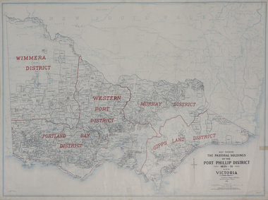 Federation University Historical Collection
Plan, Map Showing the Pastoral Holdings of the Port Phillip District 1835-1851 Now Victoria, 1932, 1932
... on Alfred Stephen Kenyon of the Historical Society of Victoria can ...Another name for Pastoral Holdings is squatting runs. Information on Alfred Stephen Kenyon of the Historical Society of Victoria can be found at http://adb.anu.edu.au/biography/kenyon-alfred-stephen-6936/text12035 Map of Victoria showing the boundaries of the Port Phillip District (Victoria) pastoral boundaries. pastoral holdings, squatters, squatting, victoria, land, crown lands, a.s. kenyon, alfred stephen kenyon -
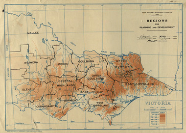 Federation University Historical Collection
Map, Victoria: Regions for Planning and Development, 1944, 1944
This map was produced for the State Regional Boundaries Committee Two colour map of Victoria showing the regions for planning and development. The regions are Central Highlands, Mallee, Wimmera, Glenelg, Corangamite, Barwon, Loddon, Goulburn, Upper Goulburn, Upper Murray, East Gippsland, West Gippsland, Port Phillip.central highlands, mallee, wimmera, glenelg, corangamite, barwon, loddon, goulburn, upper goulburn, upper murray, east gippsland, west gippsland, port phillip, victoria, m4486 -
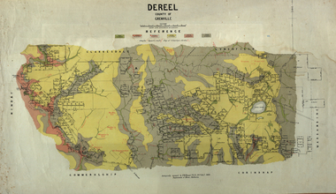 Federation University Historical Collection
Map, Dereel, County of Grenville, 1890, 1890
Dereel is in western Victoria.Geological map of Dereel in the County of Grenville featuing six colours (predominantly grey and yellow). WGS 84 Centroid Lat: 37 degrees 48 feet 50 inches S Long:143 degrees 42 feet 10 inches S N-S: 6.4 km E-W: 15.2 km dereel, ferdinand krause, crown lands department, plan -
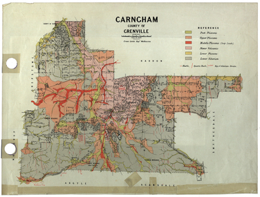 Federation University Historical Collection
Plan, Carngham, County of Grenville
A plan of Carngham, Victoria.snake valley, timber reserve, poverty point, recreation reserve, carngham, county of ripon, county of grenville, plan