Showing 172 items matching "lines plan"
-
 University of Melbourne, Burnley Campus Archives
Plan, The Oak Lawn, 1989
Tracing paper and paper copies of plan dated 20.01.1989. Scale 1:100. Sketch with grid lines. Possibly student workoak lawn, burnley gardens -
Canterbury History Group
Document - Station Buildings at Canterbury, October 1899
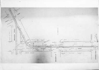
Drawing for Contract no.8826. Railway buildings at Canterbury for Victorian Railways 1899.canterbury, canterbury station, plans, railway stations, railway place, railway lines, victorian railways, canterbury road -
 Melton City Libraries
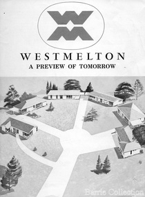
Document, West Melton: A preview of tomorrow, c.1969
"In April 1969, the first major residential development in Melton began with the release of 148 homes for purchase. This was the first stage of a staggered release of a planned 30,000 homes for 100,000 people by 1990. The development, called Westmelton Satellite City, was described as ‘a preview of tomorrow’.101 It was the first estate built in a ‘modern’ style, with curved streets, and dozens of culs de sac. Westmelton was also the first major development in Victoria to build all the supply lines to the houses – including electricity and telephone lines – underground. The six different home designs in Westmelton were ‘specially designed for the future’, and with allotments ten feet wider than regulations required, there was plenty of ‘space for gracious living’ and for a family swimming pool. The developers of this new estate were active in promoting Westmelton as a new community within the Shire of Melton. By 1971, the Westmelton City News reported that Ian McIntosh, General Manager of Westmelton, had given away $100,000 on behalf of the company ‘to aid community projects’. This included a $72,000 donation towards building a community centre in Westmelton, and $25,000 for the shire’s Olympic-sized swimming pool. Ian McIntosh and his family moved to Melton and Ian said he was ‘very much aware of the needs of [the] Westmelton community’. By the end of 1971, Westmelton was home to 100 new families. The modern residences were obviously an appealing drawcard, but so was the country feel that characterised Melton. Mrs C. Allen, described as a ‘housewife’, said she and her husband chose to move to Westmelton because of ‘the quality homes ... and we both love the clean, fresh, natural environment that surrounds us’. Similarly, Mr W. Coxhead, insurance consultant, moved to Westmelton because of the ‘clean, fresh country air’. Accountant Mr B. Swanton echoed their sentiments, describing Westmelton as ‘far enough away from the industrial pollution carried over Melbourne suburbs by prevailing westerly winds’. The new development attracted an increasing number of young, professional couples and families, representing the beginning of a significant shift from the predominantly rural and farming community of the district’s past. The Westmelton development had four different ‘neighbourhoods’ designed to cater to a variety of different lifestyle needs. Westmelton was the first to be established, followed by Brookfield, which offered ‘superb land in a rustic setting’. Brookfield Acres offered ‘wide open spaces with lots of room for a pool and even a tennis court’ on huge one-acre blocks, while Westlake was an innovative development with ‘different sized homesites’ and ‘lakeside living’.Westmelton was the first of many residential developments that would come to play a huge role in shaping the shire in the decades to follow".A marketing brochure for the Westmelton Satellite City developmentlocal significant events, council -
 Mont De Lancey
Book, Ruby M Ayres et al, The Princess Passes, Reprint 1932
A romance novel with a sweet storyline by Ruby M Ayres. Priscilla Marsh is in a bind, she needs money as her brother is in debt and she is looking after her invalid father. In love with one man she finds herself engaged to "new money" Jonathan Corbie whom she doesn't really love. A drama tears their carefully laid plans apart. Love prevails.Red cloth covered hardcover book, The Princess Passes, by Ruby M Ayres with black lettering of title, author and publisher on spine. Flower, lines and publisher initials embedded on front cover. fictionA romance novel with a sweet storyline by Ruby M Ayres. Priscilla Marsh is in a bind, she needs money as her brother is in debt and she is looking after her invalid father. In love with one man she finds herself engaged to "new money" Jonathan Corbie whom she doesn't really love. A drama tears their carefully laid plans apart. Love prevails.romance fiction, fiction -
 Bacchus Marsh & District Historical Society
Map, Lerderderg District Proposed Irrigation and Water Supply Trust (B) Plan Showing Proposed Works
The 1886 Irrigation Act in Victoria introduced the first legislation in Australia designed to enable the creation of a detailed scheme for agricultural irrigation. Part of the legislation saw the use of government funds for local irrigation projects. These local projects were managed by local irrigation trusts. The Lerderderg Irrigation and Water Supply Trust was formed in 1890. This map depicts the proposed area of the Trust and proposed works such as channels and weirs.Printed paper map of the proposed Lerderderg District Irrigation and Water Supply area showing proposed works. The map scale is 40 chains + 1 inch. The Lerderderg District lies within the Parishes of Korkuperrumul and Merrimu in the County of Bourke. At the top of the map above its title is the letter 'B; in capital lettering. A series of proposed channels are indicated on the map in red lines. A proposed weir site and alternative weir site are also indicated on the map. irrigation, water supply, lerderderg irrigation and water supply trust -
 Bacchus Marsh & District Historical Society
Map, Lerderderg District Proposed Irrigation and Water Supply Trust (C). Plan showing overlap in boundaries of the Trust District
The 1886 Irrigation Act in Victoria introduced the first legislation in Australia designed to enable the creation of a detailed scheme for agricultural irrigation. Part of the legislation saw the use of government funds for local irrigation projects. These local projects were managed by local irrigation trusts. The Lerderderg Irrigation and Water Supply Trust was formed in 1890. Printed paper map of the proposed Lerderderg District Irrigation and Water Supply. Plan showing overlap in boundaries of Trust District referred to in Mr Burke's report. The Lerderderg District lies within the Parishes of Korkuperrumul and Merrimu in the County of Bourke. At the top of the map above its title is the letter 'C; in capital lettering. A note on this map states: 'Portion of Bacchus MarshUrban District included in area of proposed Trust District shown by hatched shaded lines thus /////////////irrigation, water supply, lerderderg irrigation and water supply trust -
 Wodonga & District Historical Society Inc
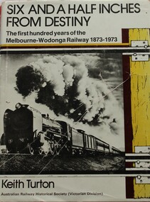
Book - Six and a Half Inches from Destiny: First 100 Years of Melbourne to Wodonga Railway, 1873 - 1973, Keith W. Turton
Inter-colonial railway communication was established in 1883 when the Melbourne - Wodonga railway was extended over the River Murray to meet the New South Wales railhead at Albury. When the two lines finally met a significant fact became apparent - the track gauges of the two systems differed by six and a half inches. For 80 years this difference created havoc until a new railway of uniform gauge was built parallel to the Victorian gauge line from Melbourne to Wodonga. This book deals with the planning, construction and the first 100 years of operation or the railway to Wodonga, together with its locomotives, stations and trains which travelled its tracks.non-fictionInter-colonial railway communication was established in 1883 when the Melbourne - Wodonga railway was extended over the River Murray to meet the New South Wales railhead at Albury. When the two lines finally met a significant fact became apparent - the track gauges of the two systems differed by six and a half inches. For 80 years this difference created havoc until a new railway of uniform gauge was built parallel to the Victorian gauge line from Melbourne to Wodonga. This book deals with the planning, construction and the first 100 years of operation or the railway to Wodonga, together with its locomotives, stations and trains which travelled its tracks.railways victoria, railway melbourne to wodonga -
![Map, [Coornmill land area available for leasing for grazing, Parish of Coornmill]. Circa 1904](/media/collectors/5e461d8021ea67224c82f2a1/items/677cde147f2053f3e5d277c3/item-media/677cdeea7f2053f3e5d27bb4/item-fit-380x285.jpg) Bacchus Marsh & District Historical Society
Bacchus Marsh & District Historical SocietyMap, [Coornmill land area available for leasing for grazing, Parish of Coornmill]. Circa 1904
This map shows an area of land north of Bacchus Marsh in the Larderderg State Park area known as the Parish of Coornmill.The map indicates an area of land which was to be made available by public tender for grazing leaseholders. The plan to do this was discussed in the Bacchus Marsh Express newspaper on the 16 July, 1904, page 2, column 7. The area reserved for grazing leases is identified by red lines on the map. The Express described the area available for grazing was 12,000 acres.A single page paper map showing an area of land in the Parish of Corrnmill to be made available for grazing leases. A photo lithographed Lands Department Map. No scale indicated. The map is pasted into a bound volume containing 76 maps or plans in total. High resolution digital image stored on BMDHS computer network. coornmill parish maps, lerderderg state park maps, agriculture bacchus marsh area -
 Department of Energy, Environment and Climate Action
Coloured mapping inks and pens
Coloured ink used to mark lines of paper maps. Could be used in pen or as a "wash" to colour areas with a soft sable hair paint brush Strict cartographic guidance was provided by the FCV’s 1947 publication - “Handbook of Conventional Signs and Symbols for Use in Forest Mapping and Plan Drawing”. It was slow and exacting work but very rewarding.Pelikan coloured inks in small glass bottlesPelikan forests commission victoria (fcv), mapping, forest measurement, surveying -
 Melbourne Tram Museum
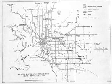
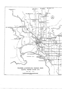
Drawing, Melbourne & Metropolitan Tramways Board (MMTB), "Melbourne & Metropolitan Tramways Board Electric Tramway System 1979", 1979
Drawing of the track plan for the Melbourne Tramway System in 1979 over two separate sheets - titled "Melbourne & Metropolitan Tramways Board Electric Tramway System 1979". Shows the route numbers and terminus names, depot locations, rail lines, cross overs and junctions. Has the name J.Chau in bottom left hand corner. Yields information about the the Melbourne tram system in 1979Drawing - print on paper P15060. Two copies held.trams, tramways, map, mmtb, trackwork, depots, route numbers, railways, junction -
 Melbourne Tram Museum
Drawing - Linking Essendon Tram lines, Melbourne & Metropolitan Tramways Board (MMTB), 1926
Set of three images of the track plans for the temporary connection between Haymarket (Flemington Road), Elizabeth St, Victoria St, and Swanston St to enable the transfer of electric trams between Essendon Depot and the workshops or other depots. From drawing P2466, dated 24-8-1926. Built during 1926. For details see the article by Mal Rowe "Linking up Melbourne's Electric Trams" in Bellcord No. 63, Sept. 2024.Yields information about the temporary trackwork that was laid in Elizabeth St Set of three A4 sheets reproduced from photographs of the large format drawing P2466.trams, tramways, trackwork, plans, victoria st, temporary track -
 Melbourne Tram Museum
Drawing - LaTrobe St - track proposal, Melbourne & Metropolitan Tramways Board (MMTB), late 1940s
Drawing is marked up in red to show the proposed track work in LaTrobe St, noting junctions, crossings, and green for existing north-south tracks. Has a note that the cable track in Spencer St was to be converted and a junction installed at the corner of LaTrobe and Spencer Sts. This junction was not installed, just the curve into Spencer St.Yields information about the LaTrobe St planning of the late 1940s.Drawing - marked up plan with red and green lines, folded with punch holes on the left hand side.latrobe st, new tramways, trackwork, cable trams -
 Federation University Historical Collection
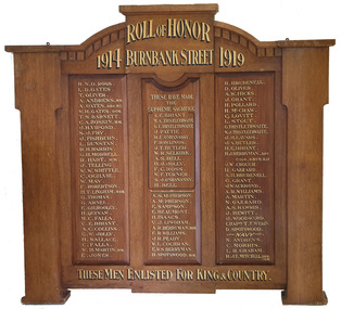
Furniture - Object, Burnbank Street Methodist Sunday School Honor Board
This honour board is thought to have been made to a design by a student of the Ballarat Technical Art School, a division of the Ballarat School of Mines. "Honor Boards. — During the past few months very many honor boards have been manufactured by Messrs R. Tunbridge and Sons, and their handsome design and workmanship have given complete satisfaction to purchasers. Some time ago, the firm gave five guineas, for prizes to the architectural class at the School of Mines for the best honor board designs, and some magnificent suggestions were submitted by the competitors. Messrs Tunbridge and Sons, in adopting this plan, gave encouragement to the students to develop along the lines of originality in architecture, and at the same time secure a very fine collection of designs. The whole of the honor boards turned out by the firm are of local manufacture and only the very choicest of Australian timbers are used. As Tunbridge and Sons have made the manufacture of honor boards a speciality they are employing a couple of first-class cabinetmakers on the work of making honor hoards only, and the lettering is also done by a local firm. An honor board which has just been completed by Tunbridge and Sons is at present on view in the firm's window facing Sturt street. It is for Holy Trinity Church, Stawell, is manufactured from Queensland maple, beautifully grained, and is of handsome gothic design. This honor Board is 8 feet in height, and measures 5 feet 6 inches across, and it contains 142 names, including 10 heroes who have won distinctions, and 37 soldiers who have made the supreme sacrifice. Tunbridge and Sons have manufactured honor boards for Miners' Rest:, Weatherboard, Scotchman's Lead, Durham lead, the Buninyong Methodist Church, Ballarat Shire south riding, St. Arnaud High School, Knox Sunday School, and Bungaree Shire Council, and there are boards for the Watchem South State School, and Springdallah in hand. People are realising that there is no need to go to Melbourne for honor boards, which are manufactured by Tunbridge and Sons of superior material, and are better finished and their prices are much below metropolitan rates." (Ballarat Star, 27 April 1918) Geoffrey Blainey's father was the pastor at the Burnbank Methodist church. Geoffrey Blainey became the first Chancellor of the University of Ballarat, a predecessor of Federation University Australia. The Honour Board was removed from the Wendouree Uniting Church when it was closed on August November 2019. Timber honour board for the Burnbank Methodist Church in Ballarat.burnbank street methodist sunday school honor board, world war one, honour board, honor board, wendouree uniting church -
 Melbourne Tram Museum
Drawing, Melbourne & Metropolitan Tramways Board (MMTB), "Melbourne & Metropolitan Tramways Board Electric Tramway System 1979", 1979
Photocopy of the track plan for the Melbourne Tramway System in 1979 over two separate sheets - titled "Melbourne & Metropolitan Tramways original pr Board Electric Tramway System 1979". Shows the route numbers and terminus names, depot locations, rail lines, cross overs and junctions. Has the name J.Chau in bottom left hand corner. See item 7740 for an original print.trams, tramways, melbourne, map, trackwork, depots, route numbers, railways, junction -
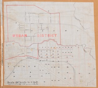 Bacchus Marsh & District Historical Society
Map, Bacchus Marsh Urban District
The date of this map has not been established but the date would be sometime after 1887 as the Bacchus Marsh Railway Station, which opened in 1887, is shown on the map. A single page paper map showing blocks of land in the urban district of Bacchus Marsh. The 'urban district' is indicated by red drawn lines on the map and includes streets and blocks on the northern side of the Werribee River in Bacchus Marsh, and streets and blocks south of the Werribee in Maddingley. Scale 10 chains to 1 inch. The map is pasted into a bound volume containing 76 maps or plans in total. High resolution digital image stored on BMDHS computer network. bacchus marsh victoria maps, maddingley victoria maps -
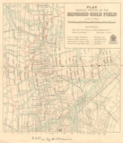 Bendigo Historical Society Inc.
Map - DEPARTMENT OF MINES VICTORIA : PLAN SHOWING PORTION OF THE BENDIGO GOLD FIELD
Department of Mines Victoria. Plan showing portion of the Bendigo Gold Field. On the back is written, in ink, J. J. Tyler 1937 Northern Area. (He was a teacher at Bendigo High - see donation notes). Across the bottom of the map is written ' M. Hill cr. Myrtle & Barnard' .The named reef lines have been numbered with ink across the bottom of the map. The gullies have been coloured with green pencil and a red pencil line is drawn through the western side of the map. Additional information: anticlinal axial lines at surface, alluvial workings, shaft sites, area of Main Goldfield, Deepest mine workings, Gold output of field to 1935, and Dividends paid 1870 - 1935.bendigo, gold mining, bendigo gold field. gold mining. tyler, j. j. -
 Warrnambool and District Historical Society Inc.
Legal record - Warrnambool City Council
These items are original records from the Warrnambool City Council and contain information on land sales and sub-divisions within the city area for the second half of the 20th century. The ledger contains the names of those involved in the sale and transfer of land and the file cards give illustrative details of the allotments – plans, maps etc. These items are of considerable significance as they are Warrnambool City Council records dealing with land sales and sub-divisions in the second half of the 20th century. They will be useful for research. .1 A metal-bound ledger with a dark red leather cover and pages printed with red and blue lines. There are red alphabetical tabs with gold print attached to the outer edges of the pages. The entries are handwritten in blue ink. .2 A grey metal cabinet, rectangular in shape and rusted on the base. The cabinet has two drawers with handles and these drawers contain file cards. The cards have a negative or transparency inserted into the top corner. .3 File cards with a negative inserted and a green backing .4 File cards similar to .3 above but of a different size. .5 A packet of unused file cards with tabs land sales and sub-divisions, warrnambool city council -
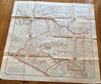 Melbourne Tram Museum
Map, Department of Lands and Survey Melbourne, Commonwealth Electoral Division of Fawkner, 1-10-1912
Shows a detailed street plan of South Melbourne, Albert Park, Prahran, South Yarra and parts of Melbourne in 1912. Used to mark the electoral boundaries of the Commonwealth Electoral Division of Fawkner. Shows all the then cable tram lines, rail lines and the electric line of the PMTT along with docks, gardens and significant buildings.Gives details of the Fawkner Electoral district in 1912.Folded sheet - Map - Commonwealth Electoral Division of Fawkner - two colours showing the subdivisions and polling placesmelbourne, fawkner, tram lines, cable trams, maps, electoral maps, south melbourne, albert park, prahran -
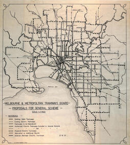 Melbourne Tram Museum
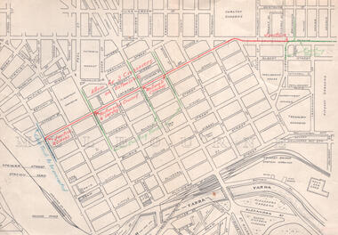
Drawing, Robert Green, Melbourne and Metropolitan Tramways Board Proposals for General Scheme, 2-1968
Drawing prepared by Robert Green for the TMSV showing the MMTB Proposals for tramway construction in the Melbourne Metropolitan Area. Traced and redrawn from the original drawing dated 27-8-1923. Shows the proposed tram lines submitted to Parliament for the report into the General Scheme as required by the MMTB Act when it was formed. See items 2088 for the original report and 2089 for a coloured print of this plan. Demonstrates the MMTB General scheme and a copy that could be used to produce further copies.Drawing - ink on mylar film.trams, tramways, mmtb, general scheme, development, parliamentk, map -
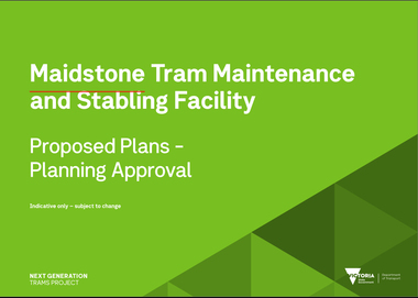 Melbourne Tram Museum
Document, Maidstone Tram Maintenance and Stabling Facility - Proposed Plans - Planning Approval
Provides the proposed plans for the Maidstone Tram Maintenance and Stabling Facility - Proposed Plans - Planning Approval stage - site plans, perspective, land use and sight lines from various locations. The information booklet looks at the project steps, planning approval, heritage issues, environmental, construction, timing and operations.Yields information about the proposed Maidstone tram depot.Digital copy of a 13 A3 page document titled - Maidstone Tram Maintenance and Stabling Facility - Proposed Plans - Planning Approval and a 12 A4 page Information booklettrams, maidstone, tramways, new depot -
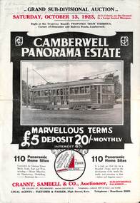 Melbourne Tram Museum
Ephemera - Real estate sale, Cranny Sambell & Co, "Camberwell Panorama Estate", Oct. 1923
... shows proposed plans for tram lines in Belmore Road and Burke... shows proposed plans for tram lines in Belmore Road and Burke ...Pamphlet advertising the sale of land at the "Camberwell Panorama Estate" - Doncaster and Bulleen Road 13-10-1923. Gives terms of sale, photos showing the views and a nearby shopping centre. Has a large photo of MMTB No. 20 on the front cover. The tramcar is of the Hawthorn Tramways Trust four-door bogie type. MMTB No 20 was an ex-Prahran and Malvern single trucker or small tram A class. Gives details of the 110 lots to be sold, terms, location, and that the tram was proposed to be extended to the corner. This extension took place in 1937. The locality plan shows proposed plans for tram lines in Belmore Road and Burke Road north of Whitehorse Road. Demonstrates the style of land sale pamphlet including the availability of tram services to prospective purchasers.Pamphlet - folded - printed in two colours of cream coloured paper with photographs and plans.has pencil notes on the top of the front page.sale of land, trams, real estate, camberwell panorama estate, east camberwell, doncaster road, bulleen road, tram 20 -
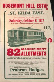 Melbourne Tram Museum
Ephemera - Real estate sale, Prahran Hodges, "Rosemont Hill Estate", Oct. 1917
Pamphlet advertising the sale of land at the "Rosemont Hill Estate", Balaclava Road, St Kilda East, 6-10-1917. On the front cover has a photo of PMTT tram No. 27. Gives terms of sale, the plan of the subdivision, and a general locality plan showing tram and rail lines. Land prices have been written in for some blocks on the pamphlet. Demonstrates the style of land sale pamphlet including the availability of tram services to prospective purchasers.Pamphlet - folded - printed in two colours of cream coloured paper with photographs and plans.has pencil notes re sale price and notes for some blocks.sale of land, trams, real estate, balaclava road, st kilda east, pmtt, tram 27, rosemont hill estate -
 City of Kingston
Pamphlet - Colour, Arthur Tuckett & Son, Auctioneers and Subdivisional Specialists, Auction of Station Estate, Moorabbin, 1923
Sales plan for land in the suburb of Moorabbin, bounded by Railway Crescent, South Road, Jasper Road and Pattersons Road.The developing urban area of Moorabbin within the City of Kingston. This land sale pamphlet illustrates the subdivision of land within the municipality and the changing demographic of the district as new houses are constructed.Colour pamphlet advertising an auction of the Station Estate Moorabbin. Incorporates details of the shopping facilities, proximity to the railway line, variety of schools and churches in the area, and a sales plan for home sites and shop fronts. Incorporates a map of the estate bordered by Pattersons Road, Japer Road, South Road and Railway Crescent. Handwritten in grey pencil top right front page: Station Estate / late [indecipherable] Handwritten in red pencil on subdivision map: x [on majority of properties marked on the map] Handwritten in grey pencil on subdivision map: additional subdivisions drawn in and large lines drawn across the mapmoorabbin, land sales, estate -
University of Melbourne, Burnley Campus Archives
Map, Map of Showgrounds, c. 1970
... Tracing paper plan with grid lines. Student project?...Tracing paper plan with grid lines. Student project? Map ...Tracing paper plan with grid lines. Student project? -
University of Melbourne, Burnley Campus Archives
Plan, Plan of Creswick Park - Hawthorn, c. 1970
... 2 Photocopies of plan showing irrigation lines. No 885.... Photocopies of plan showing irrigation lines. No 885. Plan of Creswick ...2 Photocopies of plan showing irrigation lines. No 885.creswick park, hawthorn, webb-way irrigation system -
Glenelg Shire Council Cultural Collection
Plan - Plans / Line Drawings - Port of Portland Authority Trawling Vessel Sensation, Victoria, n.d
... copy lines streak the page. Plan Plans / Line Drawings - Port ...PORT OF PORTLAND AUTHORITYFront: '30' - black texta, top right corner -
 Melbourne Tram Museum
Pamphlet, Yarra Trams, "The New Preston Depot Redevelopment", 4/2016
Pamphlet issued to crews and staff about the "The New Preston Depot Redevelopment", including a track and building plan, showing the locations of the various buildings, rail lines and roadways. On the rear cover has the logos of Keolis Downer, Yarra Trams, PTV and the Victorian Government. Yields information about the New Preston Depot and Workshops.Pamphlet, printed in colour with fold out corners and matching images - approx A3 size when opened.tramways, preston workshops, preston depot, trams, yarra trams -
Bendigo Historical Society Inc.
Map - SECTIONS ACROSS BENDIGO GOLDFIELD
Map in three sections showing sections across Bendigo Gold Field, showing anticlines, synclines, faults, stratigraphical zones and mines along the reef lines. Key shows rock types Castlemaine, Bendigo B1, B2, B3 and B4, and Lancefieldian. First part of map shows sections A-A, B-B and C-C. Reef lines drawn with mines listed: Fault line shown are the Carshalton, Stafford, New Chum, Virginia and Clarence. A datum line shows 600 ft above sea level. On bottom of plan: ' Prepared in the Geological Survey Office, Bendigo, under the direction of H. Herman, late Director of Geological Survey, from surveys by H.S. Whitelaw, Field Geologist, assisted by E.S. Usher, A.J.J. Moore and R.A. Keble.' Second section of map shows sections D-D, and E-E. Fault lines listed are the Tambour Major fault, Carshalton fault, Stafford fault, Nell Gwynne fault, New Chum fault, Deborah fault. Third section shows sections F-F and G-G. Fault lines listed are the Bird Reef fault, Kangaroo Gully fault, Langdon fault, Carshalton fault, Nell Gwynne fault, Spring Gully fault, Hustlers fault, Gravel Hill fault, Ordes fault, Thanet fault. This map forms part of the Geological Survey of Victoria, Structure of Bendigo Goldfield report, No. 47, 1923. H.Herman, late Director of Geological Survey.Geological Survey of Victoriabendigo, gold mining, reef line maps -
 Federation University Historical Collection
Map, Ballaarat Gold Field, 1861, 1861
A party of surveyors camped by Yuille's Swamp (later Lake Wendouree) and surveyed the countryside for a map to be produced by the Geological Survey of Victoria. In November 2004 the Central Highlands Regional Library presented a special edition of 200 copies of the 1861 map reproduced from a copy in their collection. Original 1861 map of Ballarat showing streets and leads. Blue dots indicate gold leads, and red lines indicate auriferous quartz reef and outcrops of quartz veins."Compiled & Drawn from the Survey of Mining Surveyors Davidson, Fitzpatrick and Cowan & the Plans in the Surveyor General's Office by J. Brahe, 21st October 1861. R. Brough Smyth, Secretary for Mines. The Honourable J.B. Humffray, M.L.A. Commr of Mines.”ballarat, map, ballarat east, lake wendouree, survey, mines, robert davidson, ballarat gold field 1861, yuille's swamp, wendouree swamp, little bendigo diggings, gold leads, old post office hill, specimen hill, bakery hill, black hill, dead horse creek, brown hill, pennyweight hill, clayton hill, soldiers hill, golden point, gum tree flat, white flat, poverty hill, chinese village, robert brough smyth, ballarat map 1861, ballaarat vineyard, dead horse gully, deadhorse creek, invermay, black hill flat, gaelic church, police reserve, magpie range, dalton's flat, caadian lead, rifle butts, powder magazine, bathing house, government camp, gold office, chinese, llanberrris, victoria theatre, charlie napier hotel, united states hotel, grape's hoel, clayton's hill, cattleyard hill, free trade hotel, esmond lead, bakery hill, black hill lead, juvenile reformatory, ballarat orphanage, lady barkly lead, triffet's slaughter yard, little bendigo, melbourne road, t. cowan, thomas cowan -
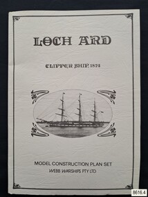 Flagstaff Hill Maritime Museum and Village
Document - Ship Model Plans, Webb Warships Pty Ltd, Loch Ard Clipper Ship, 1874; Model Construction Plan Set, 1978
The plans are presented in a keepsake folder. They show marks of sections copied and assembled together. Overall, the plans are similar to those drawn by Mr P Webb to the order of the Loch Ard Shipwreck Centenary through Mr P Williams, the organizer of the Centenary competition. “The details were based on all available information which resulted in considerable historical research…and received favourable comment from model makers because of their attention to detail…In excess of 650 sets of plans were sold before entries closed…Many plans were probably purchased by collectors and interested persons for historical reference. An illustrated historical story sheet…was prepared and enclosed with the plans…” (‘Loch Ard Shipwreck Centenary 1878-1978 Report’, November 1978). An example of the attention to historical detail on the plans is the inclusion of the following useful information about the original vessel … Tonnage….1,693 G.R.T., 1,624 N.R.T. Dimensions, Builders….Charles Connell & Co., Ltd., Scotstoun, 1873. Owners….General Shipping Co., Glasgow, (Aitken Lilburn & Co., Ltd.), and the ship’s fate. The plans, in conjunction with the scale Ship Model of the LOCH ARD also on display, are of interpretive significance to Flagstaff Hill Maritime Village. The plans provide historical and technological context to artefacts from the shipwreck, increasing understanding and appreciation of those objects. Flagstaff Hill’s collection of artefacts from LOCH ARD is significant for being one of the largest collections of artefacts from this shipwreck in Victoria. It is significant for its association with the shipwreck, which is on the Victorian Heritage Register (VHR S417). The collection is significant because of the relationship between the objects, as together they have a high potential to interpret the story of the LOCH ARD. The LOCH ARD collection is archaeologically significant as the remains of a large international passenger and cargo ship. The LOCH ARD collection is historically significant for representing aspects of Victoria’s shipping history and its potential to interpret sub-theme 1.5 of Victoria’s Framework of Historical Themes (living with natural processes). The collection is also historically significant for its association with the LOCH ARD, which was one of the worst and best known shipwrecks in Victoria’s history.Model ship plans for building the LOCH ARD. The three sets of plans are presented in a textured cream card folder with the supplier’s details and an oval cameo drawing of the LOCH ARD. The plans are detailed and drawn to scale. They and printed on good quality paper with details, scale and legends. Sheet 1: Sails and Rigging Sheet 2: Lines, Decks and Details Sheet 3: Masts and Spars Details include deck fittings, the wheel, lights and the shipping company’s house flag. The ship model plans are copyrighted in 1977 and 1978 to Webb Warships Pty Ltd. The folder has details of four locations; Australia, USA, UK and New Zealand. Sheet has a handwritten inscription.On Folder: "LOCH ARD CLIPPER SHIP, 1874, MODEL CONSTRUCTION PLAN SET, WEBB WARRIORS PTY LTD." "CONTENTS COPYRIGHT (C) 1978, WEBB WARSHIPS PTY LTD" "WEBB WARSHIPS PTY LTD, PO BOX 50, WILLIAMSTOWN, VICTORIA 3016, AUSTRALIA" Handwritten inscription on sheet 3: "834" "THE FLOATING DRYDOCK, PO BOX 16066, PHILADELPHIA, PENNA. 14114, USA" "SAMBROOK MARINE (PLANS), 84 BROAD ST. TEDDINGTON, MIDDLESEX, UK" "BYMODELS, PO BOX 3037, FORBURY, DUNEDIN, NEW ZEALAND" flagstaff hill, warrnambool, shipwrecked coast, flagstaff hill maritime museum, maritime museum, shipwreck coast, flagstaff hill maritime village, great ocean road, loch line, loch ard, captain gibbs, eva carmichael, tom pearce, glenample station, mutton bird island, loch ard gorge, ship model plans, loch ard model plans, sailing ship, loch ard centenary, webb warriors pty ltd, 1977, 1978, centenary competition