Showing 167 items matching "nepean highway"
-
 City of Kingston
Photograph - Black and white, 20 December 1945
... ), Nepean Highway and Jamieson Street. Highett Gas Works is visible...), Nepean Highway and Jamieson Street. Highett Gas Works is visible ...This aerial photograph depicts the changing landscape of Cheltenham and Highett since WWII. Photographed in 1945, there is a mix of urban dwellings and industrial development and precedes the major transformation of Cheltenham with the development of the Southland shopping centre in the 1960s and expansion in the 1990s.A large part of Cheltenham was originally established as a rural market gardening community. The railway line and station brought urban development to the area and in the north, the Highett area was dominated by the Highett Gas Works. Cheltenham became a major destination for shopping in the 1960s with the opening of Southland.Aerial photograph taken in 1945 of Cheltenham and Highett within the City of Kingston. The image includes the Highett Reserve, (top right), the Methodist Children Homes (now Southland), Nepean Highway and Jamieson Street. Highett Gas Works is visible in the top left and the land now named William Fry Reserve at the intersection of Bay Road and Nepean Highway. A visible large parcel of land on the corner of Bay Road and Nepean Highway was developed in the 1990s as the west side addition to Southland. The densely vegetated area in the upper right sector of the image is now dense with housing. Tulip Grove, Heather Grove and Gilford Street are visible bottom left. This image is possibly from the collection of aerial photographs commissioned by the Department of Crown Lands and Survey and taken by Adastra Airways.Black type: Reverse lettering VIC-10 57252 20.12.45 [lens information indecipherable] PROJ. No.5 MELB. METROP AREA White lettering: Reverse writing 57252cheltenham, highett, highett gas works, urbanisation -
 City of Kingston
Photograph - Black and white, 17 January 1951
... (top left), Park Road, Cheltenham (top right), Nepean Highway... on the Nepean Highway was a significant feature of the landscape and has ...Moorabbin, Cheltenham and Highett are suburbs in the City of Kingston with a diverse mix of development and zoning. This 1954 image shows the market gardens, farms and paddocks of the Moorabbin and Cheltenham area. which have gradually been sub-divided into The Highett Gas Works is visible and Cheltenham Park and Victoria Golf Club.The suburbs of Cheltenham and Moorabbin were originally developed with extensive market gardens. Over time the district has been transformed with the farms and paddocks replaced by housing, factories and shopping centres. The Highett Gas Works on the Nepean Highway was a significant feature of the landscape and has now been demolished. and the site has undergone remediation.Aerial photograph of Cheltenham, Moorabbin and Highett within the City of Kingston. The area depicted in this 1951 aerial view includes Wickham Road, Highett (bottom right), Keys Road, Moorabbin (bottom left), Centre Dandenong Road Cheltenham (top left), Park Road, Cheltenham (top right), Nepean Highway (left section), Graham Road and Middleton Street, Highett (bottom right). Cheltenham Park and Victoria Golf Club are visible. Nepean Highway and the Frankston railway line run centrally through the image.White type: 1416-37 538 RUN239 LENS 5312" MELBOURNE METROPOLITAN 12150 17-1-51 ↆ M539 Black pencil: N [arrow]cheltenham, highett, highett gas works, market gardens -
 Chelsea & District Historical Society Inc
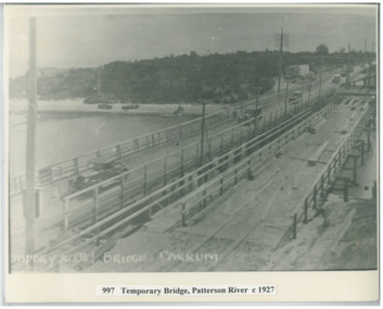
Photograph - Patterson River, Temporary and Old Bridge, c 1927
... Nepean / Nepean Highway), and a temporary bridge over Patterson... Nepean / Nepean Highway), and a temporary bridge over Patterson ...The first bridge over the river was built in the early 1880's, prior to this it was a pontoon bridge. In 1927 the construction of a concrete bridge was undertaken.Black and white photo of the old wooden road bridge (Point Nepean / Nepean Highway), and a temporary bridge over Patterson River, Carrum near the mouth of the river. Cars using the old bridge. Rowing boats on shore. Temporary and old bridge, Carrumpatterson river, road bridge, rail bridge, chelsea, transport, patterson river bridge, carrum bridge, temporary bridge, cars -
 Chelsea & District Historical Society Inc
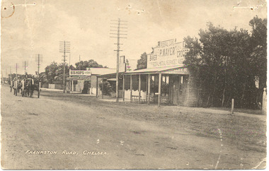
Photograph - Chelsea, Shops, c 1915
... Nepean Highway) showing P. Mayer's Store and Bishop's Store... Nepean Highway) showing P. Mayer's Store and Bishop's Store ...Black and white postcard of the main road, Chelsea (now Nepean Highway) showing P. Mayer's Store and Bishop's Store. Bishop's store is on the corner of Wimbourne Avenue, Chelsea. The road is unmade and two wagons are traveling down the road.Frankston Road, Chelseachelsea, mr p. mayer, mr bishop, wagons -
 City of Kingston
Photograph - Black and white, Aerial photograph Highett, 26 March 1956
... , Nepean Highway, Chesterville Road, Wickham Road...., Nepean Highway, Chesterville Road, Wickham Road. The photograph ...Part of broad aerial photographic survey of the area. Aerial photograph Highett - Highett Reserve, Sandpits, Gasworks, Nepean Highway, Chesterville Road, Wickham Road.The photograph shows the development of the city of Highett, suburban expansion and industrialisationsquare black and white photographic print on paper, with thick black border; printed text on bottom indicating date and other reference codeshighett, city of moorabbin, aerial photograph, suburbs, highett gas works, recreation, infrastructure -
Glen Eira Historical Society
Document - BOX FAMILY
... Nepean Road/Highway... Eastern Market Victoria Market St. Kilda Road Nepean Road/Highway ...Extensively detailed family history from 1838 in UK to present day. Provides much local history and social history into early pioneering and market gardening families. Forty one page computer print out with numerous black and white photographs.box w.h. george, box george, box mary nee cripps, box caroline, box william, box henry, box john, box anna, box eliza, box elizabeth nee avis, box francis, box lydia, moeller a., mclean n., robilliard george james, box ester, box fanny (downard), box eleanor, philbrick richard, fairlam richard, hale jasper, dendy henry, renick mark, renick stefanie (nee riemann), brighton cemetery, ormond, east brighton, prahran, centre road, jasper road, manchester road, mckinnon road, north road, brighton, box cottage, moorabbin historical society, thomas street, elsternwick, paterson road, east bentleigh, tucker road, jasper road, harwood thomas, box violet, hordeen lebbens, augustus arthur, wattle, pioneers, ancient order of foresters, council of moorabin, elster creek, primitive methodist church, lewis’ timber yard, grape growing, paling house, wells, water wagon, market gardens, farming, aboriginal people, king billy, chinese, kayon (?), kay you (yu?), cheong ki, boxer rebellion, chinese missionary, brickmakers, midwife, corben’s monumental masons, sculptor, cottage, parlour, verandah, scullery, le man’s swamp, flower nursery, chook houses, ladies college, moorabbin roads board, western market, eastern market, victoria market, st. kilda road, nepean road/highway, mckinnon, ormond, carnegie, oakleigh, murrumbeena, moorabbin, mordialloc, heathcote, bentleigh, brighton east, manchester road, brighton council, city of moorabbin, west joseph, porter harriet, moore henry, moeller a (moller), box mary, lindsay mccurry elizabeth, lindsay elizabeth, lindsay henry, lindsay frederick, schmidt william, robilliard james cpt., beckett ida, beckett nellie, beckett martha, beckett martha maud, robinson eleanor, robinson joyce, dowling thomas, anderson william snowden, mccurry henry mr & mrs, box emily jane (nee mccurry), jorgensen justin, jorgensen dr., jorgenson bertha, ross william murray, st. kilda, merrie creek, pentridge (now coburg), murray road, wyuna dunoos st, grange road, rosstown, tucker rd, elizabeth st, common school no 213 east brighton, bentleigh, steel roads tracks, rabbits, cheltenham, brighton cemetery, cheltenham cemetery, paterson road, east boundary road, baptist church, lay preachers, missionaries- china, oakleigh tyre works, belfast hotel sandhurst (bendigo), mornington, gas street lighting, brighton historical society, moorabbin primary school, bravis road, lewis street, chalmers street, grange road, butcher shops, ormond state school, oakleigh council, wedding dress, methodist children’s home cheltenham, bentleigh baptist church, auctioneer, lindsay mark, balkham jane, balkham stephen, reitman august william, fitzwilliam catherine, quashdorf (?phonetic) mr, box violet, montford paul, reitman stephanie (renick mrs), reitman william, box ada, downard alicia (lill), downard arthur, downard edward, graham elizabeth, downard octavia rose, downard william alfred, downard arthur henry (harvey), downard fanny, thompson eliza jane, box lena caroline, viloudaki rebecca, box anna (pay), pay henry, box eliza (gurr), johnson geoffrey, rushall eleanor (nellie), gurr eliza nee box, gurr jabez henry tasman, marriot william mrs, ross william murray, box gladys (nee battersby), box dulcie (bussell), bussell samuel robert, bussell norma (hoult), bussell darren lyle, bussell craig andrew, bussell sylvia june (barry), barry j. haydon, barry rachael alexandra, barry phillipa anne, barry vanessa kate, bussell joan lorraine (millie), millie john, bussell harold leslie, euston mr, purdue edgar robert, box lydia elizabeth, wilkinson coral doreen, mitchell donald, centre road, court pride of st george aof, dunoon street, vickery street, darey street/ave., oakleigh state school, methodist church, mill street, koornang road, regent street, marriage road, box olivia christina, box ernest charles, box walter william, lawson robert, lawson nancy eunice (curtis), box walter stanley, box eleanor (nellie) rushall, box martha, box john, box nellie gladys, andrews william (bill), box ray, mccurry mrs elizabeth, box william henry george, schreiber family, jorgensen family, downward arthur, downward alicia – lill, downward octavia rose, downward william alfred, downward arthur henry/harvey, cummings ida, cummings william, downward alice (nee cleary), downward ada, downward lucy (mrs bailey), downward alice, downward arthur harvey, bailey lawrence, bailey ian, bailey carol viola (bartlett), bailey colin harvey, bailey julie alison (hardware), bailey val, bailey adina, bailey david, bartlett brian, bartlett bradley grant, bartlett clayton lawrence, hardware michael, hardware dion michael colin, hardware jevon michael bailey, box elanor, box alice amelia (dale), dale george, dale elizabeth, dale lilly, dale john, dale thomas, dale rose, dale ethelbert, dale george, dale elsie, box thomas henry, box annie lavinia (rogers), rogers annie elizabeth, rogers william richard, box arthur walter, nelson dagma marie (box), box walter kingston, box marie, box cecilia eliza (ainger), ainger james, box ida may, cumming william george, cumming wendy (nee mansell), cumming susan, cumming paul, cumming felicity (steel), cumming shane, cumming melissa, cumming angel, box harold, box dorothy may (jackson), jackson frederick, jackson margaret (walker), jackson judith, walker david, walker michelle (neville), neville andrew, walker darren, walker rebecca (coyne), walker joshua, walker bradley, johnson steven, johnson carl, johnson judith (jackson), johnson peter, johnson melissa (hamid), johnson craig, ely johnson/jackson judith, ely steven, linham arthur, box thelma elizabeth (eagle), eagle keith, eagle nancye elizabeth (harpin), harkin john, harkin mary anne (howe), howe barry, howe samuel, harkin michael, harkin christopher, harkin elizabeth, eagle roddan, eagle carolyn (mansell), eagle gerard, eagle kerri – lee, box avis ann (eldridge), eldridge alf, eldridge robert, eldridge sandra, eldridge adam, eldridge nicholas, eldridge patric, eldridge john, eldridge carol (biggs), eldridge robert james, eldridge catherine elizabeth, eldridge meredith, box william john, box maud (nee hanchette), box malcome, box sandra (ede), box stephen, box nicolle, box andrew, box christine (dormer), box corrina, box jennifer (turpin), turpin phillip, box herbert, box olwyn (richard), box elaine henry, henry bruce, henry james, henry robin, henry david, box richard, box nerida (bowen), box duncan, box john, box cerwiden, box ewan, box bryan, box collen (malony), box kieran, box eden, box christopher, box pam (smith), box sue (tirchett), box thomas, box william, box george frederick, box olive (cameron), box eliza jane (thompson), box francis george, box lena caroline, box-hembrow mable alma, box charles francis, clinch mr., box robinson jessie melinda, box clay edith florence, north brighton, waun alex, waun robert, marquis peter, sheppard w., warnbach mr, marriott william mrs, box dorothy (seabrook), box hazel, box jessie, box frank (francis), seabrook len, box henry, seabrook albert, seabrook stanley allan, barry j. haydon, barry rachel alexandra, millie john, bussell harold leslie, bussell sue, bussell leanne melinda, bussell benjamin leslie, bussell lynette, box george, box jean (holms), box george, box alisa (hughes), hughes justin, hughes ebony, hughes tasman, box robin, box veronica (roman), box andrea roman, box lisa roman, box jodi roman, box malcome, box sue (kerrison), box amanda, box anthony, clay john (jack) francis, clay lynda blanche (nee sibte), clay vivien, clay majory joy, lipman vernon (vern) ronald, clay kenneth graham, clay laura jean -
 Bayside Gallery - Bayside City Council Art & Heritage Collection
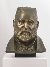
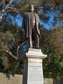
Sculpture, Margaret Baskerville, Sir Thomas Bent, c. 1911
... Baskerville that is located on the corner of Bay Street and Nepean... Baskerville that is located on the corner of Bay Street and Nepean ...This work is a plaster maquette of a large bronze statue of politician and land speculator Sir Thomas Bent by Margaret Baskerville that is located on the corner of Bay Street and Nepean Highway, Brighton.Margaret Baskerville, Sir Thomas Bent c.1911, patinated plaster, 55 x 49 x 49 cm. Bayside City Council Art and Heritage Collection. Donated by Charles Douglas Richardson, 1931.patinated plaster thomas bent, politician, mayor, premier, bust, sculpture, margaret baskerville, land speculator, speaker, local government, councillor, member of lower house, portrait -
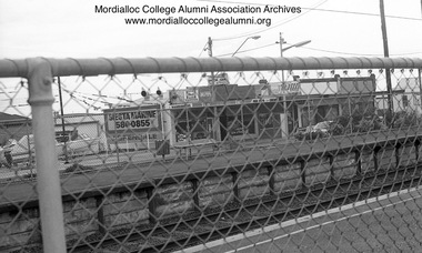 Mordialloc College Alumni Association Inc (MCAA)
Photograph, 1981 - Aspendale Station photographed from Station Street
... Photograph depicts shops on Nepean Highway side... Street Aspendale melbourne Photograph depicts shops on Nepean ...Photograph depicts shops on Nepean Highway side of Aspendale Station - Siesta Marine, the pin-ball parlour, Velo’s hairdresser/barber and The Coq au Vin Restaurant corner Foster Streetaspendale shops -
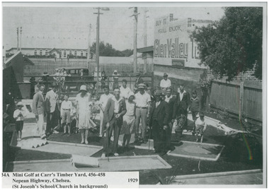 Chelsea & District Historical Society Inc
Photograph - Mini Golf, Carr's Timber Yard, 1929
... , 456-458 Nepean Highway Chelsea. In the background you can see..., 456-458 Nepean Highway Chelsea. In the background you can see ...Adults and children playing Mini Golf at Carr's Timber Yard, 456-458 Nepean Highway Chelsea. In the background you can see the Frankston railway line and St Joseph's School/Church.Black and white photo of adults and children playing mini golf at Carr's Timber Yard.sport, entertainment, mini golf, carr's timber yard, chelsea -
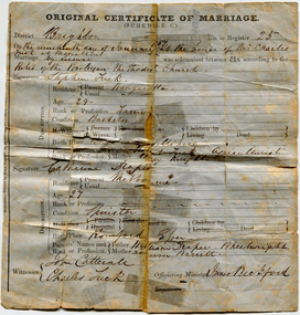 City of Moorabbin Historical Society (Operating the Box Cottage Museum)
Certificate - Certificate of Marriage for Stephen Tuck & Catherine Draper, 1857
... of the district, he had a market garden on Nepean Highway, Cheltenham... a market garden on Nepean Highway, Cheltenham. The family continued ...Stephen Tuck was one of the original settlers of the district, he had a market garden on Nepean Highway, Cheltenham. The family continued the market garden for over 70 years. It was subdivided and sold as residential blocks in 1940. Original Marriage Certificate of Stephen Tuck and Catherine Draper, in Moorabbin on 19 January 1857.stephen tuck, cheltenham, market gardens, city of moorabbin, land sales, marriage, catherine draper -
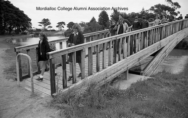 Mordialloc College Alumni Association Inc (MCAA)
Photograph, 1985 - Mordialloc-Chelsea High School students cross the newly completed footbridge
... Creek so that students no longer had to cross over the Nepean... to cross over the Nepean Highway bridge. This enabled a safer ...The footbridge finally linked either side of a Mordialloc Creek so that students no longer had to cross over the Nepean Highway bridge. This enabled a safer and quicker journey for many pupils living north of the school.Image digitised from negativemordialloc creek, foot bridge -
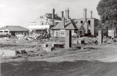 City of Kingston
Photograph - Black and white, c. 1965
... on Nepean Highway Chletenham, and was previously known... on Nepean Highway Chletenham, and was previously known ...The St John of God Home for Disadvantaged Boys was located on Nepean Highway Chletenham, and was previously known as the Methodist Children's Home. It opened in approximately 1953 and was later demolished to make way for Southland Shopping Centre. The Brothers of St John of God were a Catholic order that first arrived in Australia in 1947, establishing their first school for boys with learning difficulties. They soon acquired 20 acres in Cheltenham in 1953, which became home to 100 boys and young men who could no longer live with their familiesBlack and white image of a demolition site where the St John of God Home for Disadvantaged Boys once stood. Buildings are visible behind the boys' home site, although also slated for demolition.Black printed text on white round sticker on reverse: 231 Handwritten in red ink on reverse: 95%religion, cheltenham, orphanage, boys home -
 Melbourne Tram Museum
Photograph - TMSV tour trams 217 & 164, Keith Stodden, 13/6/1988
... , Elizabeth St) and the East Brighton (Hawthorn Road and Nepean...) and the East Brighton (Hawthorn Road and Nepean Highway) Yields ...Photographs show trams S164 and X 217 on a TMSV tour 13/6/1988 at Haymarket junction (Royal Parade and Flemington Road, Elizabeth St) and the East Brighton (Hawthorn Road and Nepean Highway) Yields information about TMSV toursSet of two colour prints.tramways, trams, tmsv, tours, haymarket, east brighton, tram 217, tram 164 -
City of Kingston
Photograph - Black and white, 20 December 1945
... Street. A large block of land runs between the Nepean Highway... Street. A large block of land runs between the Nepean Highway ...This aerial image covers a section of Cheltenham, with a large paddock yet to be converted to an industrial and later a commercial zone.This aerial photograph provides evidence of the changing landscape of Cheltenham and Highett since WWII. Photographed in 1945, the image features a large block of land now the site of site the major transformation of Cheltenham with the development of the Southland shopping centre in the 1960s and expansion in the 1990s.Aerial photograph of the Cheltenham area in the City of Kingston. This 1945 image is concentrated on the area between Bay Road and Garfield Lane with the distinctive bend into Jean Street. A large block of land runs between the Nepean Highway and the rail line. This is now the area occupied by the extension of Southland in the 1990s.cheltenham, southland, aerial photograph, highett -
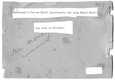 Chelsea & District Historical Society Inc
Photograph - Heffernan's Hotel, Carrum, c 1912
... situated in Point Nepean Road (now Nepean Highway). The hotel... situated in Point Nepean Road (now Nepean Highway). The hotel ...Thomas Heffernam (1860-1934) purchased the Carrum Hotel situated in Point Nepean Road (now Nepean Highway). The hotel was previously called Long Beach Hotel. The Riviera Hotel now occupies this site (2025).Black and white photo of a group of people standing in front of Carrum Hotel (Heffernan's), CarrumHeffernan's Carrum Hotel; Afternoon Teacarrum, seaford, carrum hotel, horse and cart, long beach hotel, riviera hotel, heffernan -
City of Kingston
Photograph - Black and white, 20 December 1945
... Street. A large block of land runs between the Nepean Highway... of land runs between the Nepean Highway and the rail line ...This aerial image covers a section of Cheltenham, with a large paddock yet to be converted to an industrial and later a commercial zone.This aerial photograph provides evidence of the changing landscape of Cheltenham and Highett since WWII. Photographed in 1945, the image features a large block of land now the site of site the major transformation of Cheltenham with the development of the Southland shopping centre in the 1960s and expansion in the 1990s.Aerial photograph of the Cheltenham area in the City of Kingston. This 1945 image is concentrated on the area between Bay Road and Garfield Lane with the distinctive bend into Jean Street. A large block of land runs between the Nepean Highway and the rail line. This is now the area occupied by the extension of Southland in the 1990s. It is a negative version of VKHC124.cheltenham, southland, market garden -
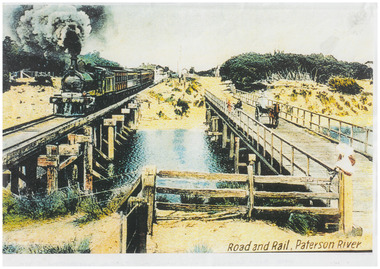 Chelsea & District Historical Society Inc
Photograph - Patterson River Postcards, Rail and Road Bridge, c 1905
... Two postcards of the road bridge (Nepean Highway... VICTORIA Two postcards of the road bridge (Nepean Highway ...The first bridge over the river was built in the early 1880's, prior to this it was a pontoon bridge. Dr. Sheldon's Magnetic Liniment was advertised as being able to relieve "at once rheumatism, lumbago, lame back, cuts, bruises or burns, will effect a cure in a remarkably short time. Price 1s 6d and 3s"Two postcards of the road bridge (Nepean Highway) with a horse and cart and people crossing and single line rail bridge , with a steam train crossing over Patterson River, near the mouth of the river. One card has been coloured, the other has been modified to advertise Dr Sheldon's Magnetic Liniment.DR SHELDON'S NEW DISCOVERY 16' & 3' BANISHES ALL PAINS AT CARRUM VICTORIApatterson river, road bridge, rail bridge, dr sheldon's linament, chelsea, steam train, transport, chelsea bridge, patterson bridge -
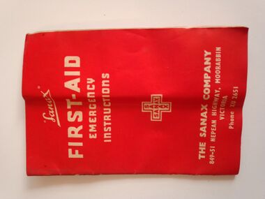 Warrnambool RSL Sub Branch
Equipment - WW2 Field Medical Kit- contents, part of, Sanax FIRST AID EMERGENCY INSTRUCTIONS Booklet
... . THE SANAX COMPANY 849-51 NEPEAN HIGHWAY MOORABIN VICTORIA. Phone... INSTRUCTIONS. THE SANAX COMPANY 849-51 NEPEAN HIGHWAY MOORABIN VICTORIA ...Small booklet, 23 pages. Red Cover of thin cardFront Cover: Sanax FIRST AID EMERGENCY INSTRUCTIONS. THE SANAX COMPANY 849-51 NEPEAN HIGHWAY MOORABIN VICTORIA. Phone XU2651 Inside Pages: first-aid treatment instructions and advertising of Sanax products -
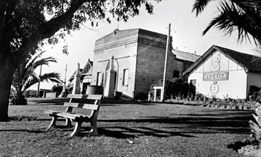 City of Kingston
Photograph - Black and white, c.1945
... This photograph shows the Protestant Hall on Nepean Highway... when Nepean Highway was widened. The Protestant Hall still ...This photograph shows the Protestant Hall on Nepean Highway Cheltenham, which at the time of the photograph was used by the Returned Sailors' Soldiers' and Aimen's Imperial Leage of Australia (RSSAILA). The building facade, World War I memorials, fire station building and road plantation are also in view. The Protestants Hall was built by the Cheltenham Protestant Hall Company Limited in 1886. The hall has been used for a wide variety of purposes; in earlier times it served as the Sunday School for the Methodist Home for Children, and later as a schoolhouse when the Beaumaris School (now Cheltenham State School) No 84 met with overcrowding problems. It was also a popular venue for annual balls and regular dances held by church groups and sporting organisations. The City of Moorabbin purchased the building in the 1920's for use by the Returned Soldiers and Sailors League, in whose hands it remained until the late 1970s when it was taken over by a catering firm. During the 1920s, and right up to the late 1950s, it also served as Cheltenham's picture theatre. The three memorial columns, one from the South African War, one from World War I and one from World War II previously located in front of the hall were relocated when Nepean Highway was widened. The Protestant Hall still stands at 1261 Nepean Highway CheltenhamBlack and white digital image depicting three buildings. The right hand building bears a sign that reads RSSAILA. There are trees and a bench seat in the foreground. There is a World War I memorial pictured. world war i, world war ii, protestant hall, cheltenham, returned sailors' soldiers' and aimen's imperial leage of australia (rssaila), returned and service's league (rsl) -
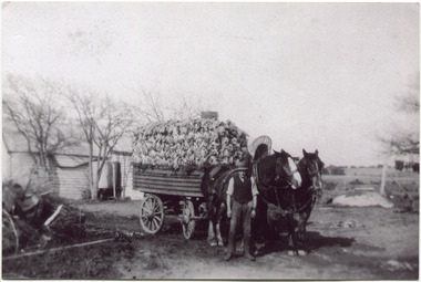 City of Moorabbin Historical Society (Operating the Box Cottage Museum)
Photograph, Black & White, V Peterson East Boundary Rd East Bentleigh loaded wagon c1900, original c1900
... the Plateways that ran along Centre Road and Nepean Highway. ... the Plateways that ran along Centre Road and Nepean Highway. The early ...The Peterson family were early settlers in Moorabbin Shire and established a market garden in East Boundary Road East Bentleigh. Vic Peterson and family loaded the crop - cabbages - onto the horse drawn wagon and set off to the Melbourne market using the Plateways that ran along Centre Road and Nepean Highway. The early settlers like the Petersons , in the Parish of Moorabbin County of Bourke after Henry Dendy's Special Survey Brighton 1841, established market gardens, fruit & flower gardens, poultry & dairy farms, vineyards as well as shop businesses, blacksmiths, chemists, nursing homes and schools & Churches.Black & White photograph showing Vic Peterson beside the horse drawn wagon loaded with 35dozen ( 12x 35) cabbages setting off to market c 1900 Original re-digitised by H Stanley 2005Back Hand written informationwagons, vulcan trucks, draught horses,, peterson vic, marriott dick, cabbage crops, vegetable crops, poliomyelitis epidemics 20thc , elster creek, plateways moorabbin shire, smith j l; smith mary ann, stanley helen, smith vic, smith harry redvers, chaff cutter, horse drawn carts, toll gates brighton, motor cars 1900, steam engines, early settlers, bentleigh, mckinnon, parish of moorabbin, city of moorabbin, county of bourke, moorabbin roads board, shire of moorabbin, henry dendy's special survey 1841, were j.b.; bent thomas, o'shannassy john, king richard, charman stephen, highett william, ormond francis, maynard dennis, market gardeners, vineyards, orchards -
 Chelsea & District Historical Society Inc
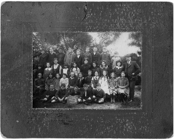
Photograph - Chelsea State School, Parents Committee at "Joss House", 1914
... , near the Nepean Highway. Due to its Oriental appearance..., near the Nepean Highway. Due to its Oriental appearance ...In January 1912, a small school was established at Chelsea, with 65 students, in Hoadley’s Hall, located on Main Road, Chelsea, near the Nepean Highway. Due to its Oriental appearance, the local people called this hall “The Joss House.” A new brick school was built on Argyle Avenue and officially opened on 27 January 1915.Black and white photo Parents Committee of Chelsea State School, in front of the school with four scouts with English flags.chelsea, education, chelsea primary school, school, parents committee, scouts, joss house, chelsea state school -
 Chelsea & District Historical Society Inc
Photograph - Chelsea State School, Grade 6, 1920
... , near the Nepean Highway. Due to its Oriental appearance..., near the Nepean Highway. Due to its Oriental appearance ...In January 1912, a small school was established at Chelsea, with 65 students, in Hoadley’s Hall, located on Main Road, Chelsea, near the Nepean Highway. Due to its Oriental appearance, the local people called this hall “The Joss House.” A new brick school was built on Argyle Avenue and officially opened on 27 January 1915.Black and white photo of Grade 6 children at Chelsea State School, in 1920, with the Headmaster, George Rogerschelsea, education, grade 6, george rogers, school, chelsea state school -
 City of Moorabbin Historical Society (Operating the Box Cottage Museum)
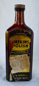
Domestic object - Watkins Polish, J. R. Watkins Co (USA), 20thC
... at Highett on a six acres on the east side of Nepean Highway... acres on the east side of Nepean Highway (no. 1123) in 1954 ...The J. R. Watkins Co. opened its first overseas branch in Australia in 1935. The J. R. Watkins built a large factory at Highett on a six acres on the east side of Nepean Highway (no. 1123) in 1954. The J. R. Watkins company was founded in 1868 in Plainview, Minnesota USA, moving to Winona in 1885, by J. R. Watkins.Example of industry in the City of Moorabbin.Amber glass bottle with a metal screw on lid. A paper label is on the front of the bottle 'Watkins Polish" printed in yellow, black and white.PRINTED ON LABEL: 11 Fluid ounces - WATKINS POLISH - Gives a hard dry lustre excellent for Dusting For cleaning, dusting and polishing furniture, pianos, woodwork, linoleum, hardwood floors and all polished surfaces. Directions: If the article to be polished is dirty or gummy, clean it by washing with mild soap and warm water. Apply Watkins Polish with a damp, soft cloth (Dampened with water and wrung almost dry). The Polish may be poured on the damp cloth or on the surface to be polished. In either case rub it all with a dry cloth to obtain a high polish. When dusting, dampen the cloth with Watkins Polish - it keeps down the dust and gives a lustre which is neither greasy not gummy. The J. R. Watkins Co. Melbourne - Sydney - Adelaide - Kogarah EMBOSED ON BOTTLE: "The J.R.Watkins co. Made in Australia" the j. r. watkins co, highett, polish -
 Bayside Gallery - Bayside City Council Art & Heritage Collection
Sculpture, Margaret Baskerville, Sir Thomas Bent, 1913
... in her career. Originally located in the centre of the Nepean... career. Originally located in the centre of the Nepean Highway ...Arguably Margaret Baskerville’s most famous work, the bronze statue of politician and land speculator Sir Thomas Bent was Baskerville’s first public commission and a significant turning point in her career. Originally located in the centre of the Nepean Highway, in Brighton, it became somewhat of signpost for many Melbournians until it was relocated to the corner of Bay Street in 1980.The statue of Sir Thomas Bent is of historic and social significance to the State of Victoria. The statue is historically significant for commemorating Bent's long, active and infamous political career in Victoria. He was responsible for many important speculative ventures both within his electorate and in the wider context of Victoria. Although not without thought for personal gain, Bent was a committed advocate of public utilities, railways, roads, tramways and gasworks. The statue is historically significant as the first large public commission given to a woman sculptor in Victoria. This work helped the sculptor, Margaret Baskerville, preserve her name as Victoria's first professional woman sculptor. The statue is socially significant as testimony to the late nineteenth century land boom and the financial and political corruption and scandals that accompanied it. https://vhd.heritagecouncil.vic.gov.au/places/12614bronze and granite thomas bent, politician, mayor, premier, bust, sculpture, margaret baskerville, speaker, member of parliament, member of lower house, local government, councillor, brighton, public art, bayside -
 City of Kingston
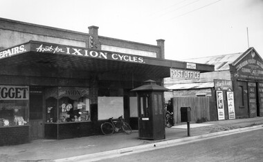
Photograph - Black and white, c. 1940
... , the post office and the Poultry Auction Centre along Nepean Highway..., the post office and the Poultry Auction Centre along Nepean Highway ...Black and white image featuring Mr Whalebone's bicycle shop, the post office and the Poultry Auction Centre along Nepean Highway, Moorabbin. In front of the shops is a telephone booth. There is a bike leaning against the front window of the post office and between the post office and the poulty auction shop is a picket fence with a gate, and two boys are coming through the gate, one of them wheeling a bike.Black printed ink on a round white sticker on reverse: 160 -
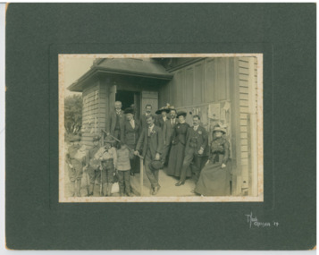
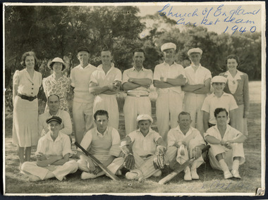 City of Moorabbin Historical Society (Operating the Box Cottage Museum)
Photograph, Black & White, St Matthew's Church of England Cricket Team c 1940, c1940
... of England was erected in Cheltenham beside the Nepean Highway near... was erected in Cheltenham beside the Nepean Highway near Charman Road ...The Cheltenham parish was created in 1865 by excising a portion of the parish of St Andrews Brighton. A small brick church was completed in 1867 to serve a rural community stretching from Brighton South (Moorabbin) to Mordialloc. 1867 St Matthew's Church of England was erected in Cheltenham beside the Nepean Highway near Charman Road. The early settlers established a tennis club, cricket team and social groups.St Matthew's Church of England Cheltenham was erected in 1867 and was integral to the spiritual well being and social life of the early settlers.Black & White photograph of the St Matthews Church of England Cricket team Cheltenham c 1940Front ; Church of England Cricket Team 1940 Back ; Written - Ladies / Hilda Biehl, Bertha Schneeberber, Mrs Wootton, / We made afternoon tea from / a kerosene tin for 30 players / each Saturday they played at home !!smith j l; smith mary ann, stanley helen, chaff cutter, horse drawn carts, toll gates brighton, motor cars 1900, steam engines, early settlers, bentleigh, parish of moorabbin, city of moorabbin, county of bourke, moorabbin roads board, shire of moorabbin, henry dendy's special survey 1841, were j.b.; bent thomas, o'shannassy john, king richard, charman s, highett william, ormond francis, maynard dennis, market gardeners, vineyards, orchards, -
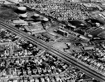 City of Kingston
Photograph - Black and white, c. 1970
... The Highett Gas Works were a landmark along the Nepean... Parkdale The Highett Gas Works were a landmark along the Nepean ...The Highett Gas Works were a landmark along the Nepean Highway for many years. With the cessation of the gasification of coal and the introduction of natural gas to Victoria, the gas holders were demolished and the Sir William Fry Reserve was developed on the southern end of the site. The Gas and Fuel redeveloped the northern end of the site with modern offices and laboratories for the organisation's scientific services. At this time, the chimney and retort house were retained.The Highett Gasworks had its beginning in 1939 operated by the Central Brighton and Moorabbin Gas Co Ltd. The company had expanded its gas production facilities to Highett where it had purchased 45 acres of land adjacent to the Melbourne-Frankston railway line. The first gasholder was erected on the Highett site in 1927 and connected with high pressure mains to the Brighton Gas Works. In 1939 the building program including gasometers, the vertical retort house and coal store was completed and gas making commenced. Its area of supply covered approximately 70 square miles and included the municipalities of Brighton, Sandringham, Moorabbin, Mordialloc, Chelsea and part of Dandenong. The Gas and Fuel Corporation eventually took over operations and with the disaggregation and privatisation of the organisation, the site was eventually closed c. 2002.Black and white aerial photograph featuring the Highett Gas Works with gasholders and retort house. In the top right-hand corner, a former Highett Primary School on Graham Road can be viewed. Photograph includes Bay Road, Royal Avenue, Princess Avenue and Jackson Road (Highett) and Alfred, Turner and Sandford Streets (Moorabbin).Handwritten in black ink: [indecipherable] in a circle Handwritten in red ink: 70% Four velcro display adhesivesgasification of coal, gas and fuel corporation of victoria, gasholders, highett, moorabbin, utilities -
City of Kingston
Photograph - Black and white, 5 January 1984
... and Nepean Highway (bottom left), Balmoral Drive/McSwain Street... and Nepean Highway has now been replaced by high rise apartments ...Cheltenham and Heatherton are suburbs in the City of Kingston that were originally established as a rural market gardening community. The market gardens, farms and paddocks have gradually been sub-divided into housing and industrial estates and associated infrastructure such as schools and shopping facilities. This aerial image covers a diverse section of the City of Kingston, taking in the suburbs of Cheltenham, Heatherton, Mentone and Parkdale. By 1984, the market gardens of the district have been replaced by housing and factories. The Nylex factory is visible and now closed. Mentone Bowl on the corner of Warrigal Road and Nepean Highway has now been replaced by high rise apartments, another feature of the changing landscape in the City of Kingston. The vacant land now occupied by the Moorabbin Airport Direct factory Outlet (DFO) is also depicted.Aerial photograph of Cheltenham, Heatherton, Mentone and Parkdale within the City of Kingston. The area depicted in the 1984 aerial view includes Centre Dandenong Road and Cheltenham East Primary School (top left), Kingston Heath Reserve (top right), intersection of Lower Dandenong Road, Warrigal Road, Balcombe Road and Nepean Highway (bottom left), Balmoral Drive/McSwain Street Parkdale (bottom right).White text: 3831-179 Lens information [indecipherable] RINGWOOD M/S 7922-3 RUN 16 [Clockface image] 5,300' ASL VIC DLS© 5-1-84cheltenham, heatherton, mentone, parkdale, market gardens, urbanisation -
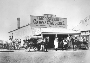 City of Kingston
Photograph - Digital image, Black and white, Moorabbin Co-operative Store, c. 1910
... standing in front of Moorabbin Co-operative Stores, Nepean Highway... standing in front of Moorabbin Co-operative Stores, Nepean Highway ...Black and white image depicting two men wearing aprons standing in front of Moorabbin Co-operative Stores, Nepean Highway Cheltenham. Exchange Hotel to the right. Three horse drawn wagons, on the left two white horses with a man holding the reins, one carrying a load with hessian sacks and another on the far right with a man in the seat of the wagon also wearing an apron, suggesting they are workers at the store.Black and white image of two men wearing aprons standing in front of Moorabbin Co-operative Store with three horse drawn wagons, on the left two white horses with a man holding the reins, one carrying a load with hessian sacks and another on the far right with a man in the seat of the wagon also wearing an apron. A sign on the left hand side of the building Havelock Tabacco.Printed in black text a round white sticker: 75 Hand written in red ink: 75%horse drawn wagon, workers, moorabbin, cheltenham, commerce, trade -
City of Kingston
Photograph - Colour, 31 January 1993
... , Kananook Creek and Nepean Highway. The railway line can be seen... and Nepean Highway. The railway line can be seen as it veers inland ...Patterson Lakes is a suburb in the City of Kingston that is built one kilometre upstream of the mouth of the Patterson River. The area is bordered by the Patterson River and Eel Race Drain which enters the Kananook Creek. The suburb consists predominantly of newer housing developments and the tidal canal system of the development joins Port Phillip Bay. Patterson Lakes and the Kananook Creek were previously part of the extensive Carrum Carrum Swamp. The area was once a source of fish and eels for the Mayone-Bulluk clan of the Bunurong people. Over time the area was drained and in 1973 investigations commenced into the development of a unique residential area that would be built adjacent to canals and waterways. It was originally proposed to be known as "Gladesville". The development would give the suburb's homeowners access to Port Phillip Bay "from their back door". Circa 1974, the area was rezoned from rural to residential and named Patterson Lakes. Development has been continuous since the 1970s with construction of residential housing, schools, shopping centres, marinas, a hotel and library.Laminated colour aerial photograph of the Carrum and Patterson Lakes region within City of Kingston. This 1993 image includes Patterson River Secondary College, Roy Dore Reserve, Kananook Creek and Nepean Highway. The railway line can be seen as it veers inland from Eel Race Road, Seaford. The section of Ocean Reef Drive and Palm Beach Drive in Patterson Lakes appears to be a recent development with many spare blocks and new houses under construction.Black typed lettering on white adhesive label: 31.1.93 Black typed lettering on white adhesive label: 27E/7140 31/1/93 12.55 pm Black typed lettering on white label: 7140 Yellow round adhesive label located on left sidepatterson lakes, seaford, kananook creek, carrum carrum swamp, canals and waterways