Showing 278 items
matching original survey
-
 City of Moorabbin Historical Society (Operating the Box Cottage Museum)
Document - Copy of Death Certificate Elizabeth Box 1914, 1914
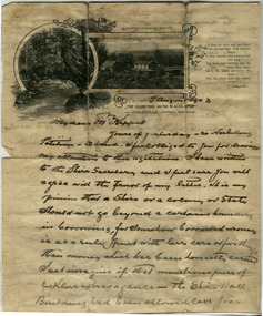
Elizabeth Avis- Box 1835-1914 was born in Sussex, married William Box in 1854 and arrived in Melbourne in 1855. William’s parents George and Mary Box and his siblings sailed with them. William & Elizabeth at first leased land in the area of the ‘Dendy Special Survey Brighton 1841’ and then purchased the property with the pioneer cottage 1868 & 1869. William & Elizabeth established a market garden and raised 13 children. 1888 they built a larger 2nd house in front of the original cottage. William died in 1902 and Mary sold 9acres in 1908 to W. .Snowden Anderson – it later became Joyce Park where the reconstructed Box Cottage Museum now stands. After Elizabeth died her daughters Ada and Violet lived on the 1acre property until 1917 when August Reitman, a potter and monumental mason, leased the house and land. He established his pottery business and purchased the property in 1935. The business moved in 1953 but continued to use the cottage as a workshop/ storeroom until it was sold to Lewis Timber P/L in 1970 Elizabeth & William Box settled in the pioneer Cottage in Jasper Road East Brighton 1868 and established a market garden whilst raising their 13 children. This Cottage was reconstructed in Joyce Park, Ormond 1984 and is the home of City of Moorabbin Historical Society. In 1960 many local residents responded to a call for the donation of historical artefacts and the Box Cottage Museum now preserves this eclectic collection for the community. A certified true copy of the Death Certificate of Elizabeth Avis- Box 1835 -1914 in a wooden picture frame, obtained from The Births, Deaths and Marriages Office Melbourne Victoria 18/6/1985 THIRD SCHEDULE / DEATHS in the District of East Brighton in the State of Victoria Registered by George William Ward / Dated 1914 / 1st July 1914 Jasper Rd Bentleigh Shire of Moorabbin County of Bourke / Elizabeth Box / Home duties/ …… Dr A T Joyce Certified ‘true copy of an entry in a register’……… Signed by Paul Kenny Registration Officer 18 June 1985 box elizabeth avis, box william, moorabbin, bentleigh, brighton, ormond, pioneers, market gardeners, brighton cemetery, box george, box mary cripps, reitman august, anderson w. snowden, joyce park ormond, box cottage museum dendy’s special survey brighton 1841, -
 City of Moorabbin Historical Society (Operating the Box Cottage Museum)
Document, Death Certificate William Box 1902, 1985
William Box1834-1902 and Elizabeth Avis Box 1835-1913 came to Australia with his parents George and Mary Cripps-Box and siblings in 1856. Caroline Box, the eldest daughter of George and Mary Cripps-Box, remained in England working as a cook until she joined the family in Australia in 1863. William Box with his wife Elizabeth Avis Box at first leased market garden allotments in Brighton that was part of the Henry Dendy Special Survey 1841. In 1868 and 1869 they purchased 2 blocks with a pioneer’s cottage in Jasper Road East Brighton ( now Ormond / McKinnon ) where they established a market garden, built a 2nd house and raised 13 children. In 1908 Elizabeth sold most of the land retaining 1 acre with the dwellings in which she resided with her two daughters until her death 1913. The original pioneer cottage was reconstructed in 1984 and is known as Box Cottage Museum William & Elizabeth Avis- Box settled in the pioneer Cottage in Jasper Road East Brighton 1868 and established a market garden whilst raising their 13 children. This Cottage was reconstructed in Joyce Park, Ormond 1984 and is the home of City of Moorabbin Historical Society. In 1960 many local residents responded to a call for the donation of historical artefacts and the Box Cottage Museum now preserves this eclectic collection for the community. A certified true copy of the Death Certificate of William Box 1834 -1902 in a wooden picture frame, obtained from The Births, Deaths and Marriages Office Melbourne Victoria 1985 THIRD SCHEDULE / DEATHS in the District of East Brighton in the State of Victoria Registered by W. Ward Certified ‘true copy of an entry in a register’……… Signed by Paul Kenny Registration Officer 1985 box william, box elizabeth, brighton, moorabbin, cottages, pioneers, ormond, colonial, mckinnon, dendy henry, museums, box alonzo, market gardeners, box cottage museum -
 City of Moorabbin Historical Society (Operating the Box Cottage Museum)
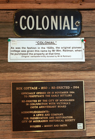
Furnishings, 'Colonial' metal name plate c1917, c1917
c1917 it became fashionable to give residences a 'name' . Mr August Reitman attached this metal nameplate to the Cottage.when he began leasing the property. The Reitman family purchased the property in 1935 and resided there until 1953 . The property was sold to Lewis Timber Co . c1970. William Reitman, the son of August, donated the sign to the CMHS c1984 during the reconstruction of the pioneer cottage in Joyce Park ,Ormond.An unknown pioneer built the Cottage c1840 then William Box purchased it 1868 and his family resided there until it was leased to August Reitman in 1917. August placed this nameplate on the Cottage c1917. William Reitman, the son of August donated the sign to CMHS in 1984 when the Cottage was reconstructed in Joyce Park Jasper Road OrmondThe original metal name plate attached to Box Cottage c1917 by August Reitman when he and his wife began renting the property. 'COLONIALbox william, box elizabeth, reitman august, moorabbin, bentleigh, brighton, ormond, dendy's special survey 1841, market gardeners, sculptors, reitman william, lewis timber co ltd, box cottage museum -
 City of Moorabbin Historical Society (Operating the Box Cottage Museum)
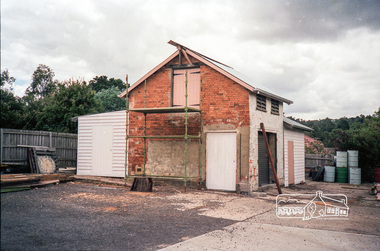
Plaque, Official Opening Reconstruction Box Cottage 1984, 1984
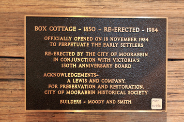
The original small, pioneer cottage was built in the late 1840s to early1850s, by an unknown pioneer. It was located on part of a 30 Acre allotment that was originally part of Dendy’s Special Survey granted in 1841. The doors and window sashes, (made of red deal joinery timber), as well as the brass locks and fittings, are from the original cottage, and were imported from England. The fire-place bricks are from the original cottage, and are sun-dried, (not kiln fired), and are hand-made. Convict marks can be seen on two bricks. There is a small display of external cladding shingles from the original pioneer cottage. These shingles were hand-split, and most likely made from locally collected timber The nails included in this display were used to fasten the shingles on the original cottage, and are also hand-made. The enamel nameplate, “Colonial”, on the wall of the cottage, was the name chosen for the original pioneer cottage when Mr August Reitman, a sculptor, began leasing the property in 1917. August purchased the property c 1935, for 1200 Pounds approximately and resided there until 1953. He sold it to Lewis Timber Co Pty Ltd in 1970. In 1974 Mr Lewis, a timber specialist, found the dilapidated building on the property he had recently purchased in Jasper Rd and suggested it be reconstructed and relocated. Moorabbin City Council agreed and the cottage was rebuilt about 250 metres from its original site. The cost of the rebuild was met by 'Victoria's 150th Committee, plus a small grant from the City of Moorabbin, and Mr Laurie Lewis donated much of the timber for the reconstruction. CMHS volunteer members operate the Box Cottage Museum which is open to the public on the last Sunday of the month or by appointment. the Official Opening of the Reconstructed Box Cottage on November 18th 1984A plaque commemorating the Official Opening of the Reconstructed Box Cottage on November 18th 1984BOX COTTAGE - 1850 - RE-ERECTED - 1984box william, box elizabeth avis, deny's special survey 1841, brighton, moorabbin, ormond bentleigh, mckinnon, market gardeners, pioneers, early settlers, reitman august, reitman william, lewis timber co pty ltd, moorabbin city council 1934 – 1994, -
 City of Moorabbin Historical Society (Operating the Box Cottage Museum)
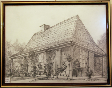
Drawing, charcoal of reconstructed Box Cottage c 1985, c1985
The original small, pioneer cottage was built in the late 1840s to early1850s, by an unknown pioneer. It was located on part of a 30 Acre allotment that was originally part of Dendy’s Special Survey granted in 1841. The doors and window sashes, (made of red deal joinery timber), as well as the brass locks and fittings, are from the original cottage, and were imported from England. The fire-place bricks are from the original cottage, and are sun-dried, (not kiln fired), and are hand-made. Convict marks can be seen on two bricks. There is a small display of external cladding shingles from the original pioneer cottage. These shingles were hand-split, and most likely made from locally collected timber The nails included in this display were used to fasten the shingles on the original cottage, and are also hand-made. The enamel nameplate, “Colonial”, on the wall of the cottage, was the name chosen for the original pioneer cottage when Mr August Reitman, a sculptor, began leasing the property in 1917. August purchased the property c 1935, for 1200 Pounds approximately and resided there until 1953.. In 1974 Mr Lewis, a timber specialist, found the dilapidated building on property he had recently purchased in Jasper Rd and suggested it be reconstructed and relocated. Moorabbin Council agreed and the cottage was rebuilt just about 250 metres from its original site. The cost of the rebuild was met by 'Victoria's 150th Committee, plus a small grant from the City of Moorabbin, and Mr Laurie Lewis donated much of the timber for the reconstruction. A charcoal drawing of the reconstructed 'Box Cottage', in a wooden frame with glass, by Joe Becker c 1985signed : Joe Beckerbox cottage reconstruction, moorabbin, ormond, box william, box elizabeth, brighton, pioneers, market gardeners -
 Geelong RSL Sub Branch
Mess Tins, 1939
This mess tin has been issued to VX 26729 Thomas J Patullo who served with the AIF Field Survey Unit, RAE, during WW2.This mess tin is the original that was issued to VX26729 Thomas J Patullo during his service in WW2.Two Silver Colour, metal, oblong shaped mess tins with handles. One tins is smaller and fits inside the other when not in use.On the back of the small tin - VX26729 T J Patullo. On the back of both tins where the handle is attached to the body - L A Co 1939 and the Defence Logo.mess tins, ww2 -
 Eltham District Historical Society Inc
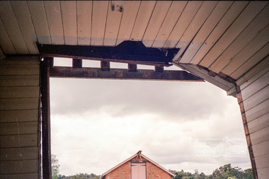
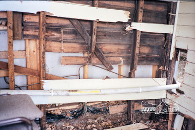
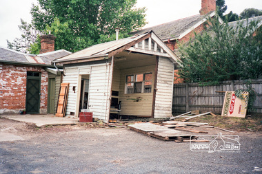
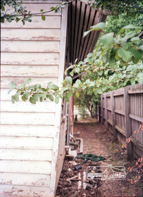
Photograph, The former Police residence at 728 Main Road under renovation work for future Shire of Eltham use, c.Nov. 1991
The original Eltham Police Station was used up till about 1960. The building was then taken over and used by the Vermin and Noxious weeds Destruction Section of the Department of Crown Lands and Survey. They vacated the building c.March 1981 and it remained unoccupied for a period of time whilst its future was discussed in Council. About 1986 the Shire took over use of the Police Residence and renovated it for use by the Shire Parks and Environment Office. The original Police Station was termite infested and was removed. It was later replaced by a replica building which was used as a lunchroom for Council employees working at the site. Based on photos contained in the 1992 Bick Heritage Study of the Police Residence and Stable, this roll of film was taken Nov 1991.Roll of 35mm colour negative film, 7 stripsKodak GA 100 5095shire of eltham, justice precinct, police residence, police station, local history centre -
 Eltham District Historical Society Inc
Photograph, The original Police Stables at 728 Main Road under renovation work for future Shire of Eltham use, c.Nov. 1991
The original Eltham Police Station was used up till about 1960. The building was then taken over and used by the Vermin and Noxious weeds Destruction Section of the Department of Crown Lands and Survey. They vacated the building c.March 1981 and it remained unoccupied for a period of time whilst its future was discussed in Council. About 1986 the Shire took over use of the Police Residence and renovated it for use by the Shire Parks and Environment Office. The original Police Station was termite infested and was removed. It was later replaced by a replica building which was used as a lunchroom for Council employees working at the site. Based on photos contained in the 1992 Bick Heritage Study of the Police Residence and Stable, this roll of film was taken Nov 1991.Roll of 35mm colour negative film, 7 stripsKodak GA 100 5095shire of eltham, justice precinct, police residence, police station, local history centre -
 Eltham District Historical Society Inc
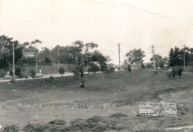
Photograph, Alistair Knox Park, Eltham, c.1970, 1970c
View from northwest corner showing survey pegs for trees and two ponds. Main Road has been duplicated. Bridge Street intersection showing the rock wall on the east side of the original Main Road (Maria Street). Burgoyne's Store and Eltham Uniting Church in distance at centre right and Our Lady Help of Christians at centre left.In February 1968 an unknown person took a series of photos from the Eltham Hotel at Pitt Street heading north along Main Road through the shopping centre to just north of Elsa Court covering the length of the section of Main Road which was duplicated shortly thereafter. Shows the condition and environment of the streesscape of Main Road, Eltham immediately prior to the duplication between Pitt Street and Elsa Court through the shopping centre. Also shows a number of shops and businesses that operated at that time.Black and white photographduplication, eltham, main road, bridge street, burgoyne's shop, eltham uniting church, our ladys church, maria street -
 Warrnambool RSL Sub Branch
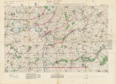
MAP TO ACCOMPANY HEAVY ARTILLERY SCHEME FOR MOBILE WARFARE".....marked with 'Lanes' and Corps/Division Boundaries, Ordnance Survey, 1:40,000, France. Sheet 62c, Dec 1917. (centring on Peronne and Mont St Quentin), December 1917
Shows detail of Artillery Planning in the area of Peronne & Mont St Quentin. Inscribed "Map to accompany H.A. Scheme for Mobile Warfare". Marked with 'Lanes' and Corps/Division Boundaries.The donor, Staff Sergeant R.O. (Bob) Snape, Reg No 8651, enlisted as a Stretcher Bearer in 1915 but, because of his secretarial skills was employed in HQ positions as soon as he arrived in France and as a stenographer who worked as Confidential Clerk to General Sir John Monash from June to December 1918; and subsequently, for General Sir Talbot Hobbs until June 1919. The map was very likely directly used in the planning of the 1918 battles such as Mont St Quentin.Original Item recovered from possibly Australian Corps HQ, probably between the Armistice, 11 November 1918, and June 1919, when Staff Sergeant R.O.(Bob) Snape was repatriated. Shows detail of Artillery Planning in the area of Peronne & Mont St Quentin. Inscribed "Map to accompany H.A. Scheme for Mobile Warfare". Marked with 'Lanes' and Corps/Division Boundaries.snape collection -
 Warrnambool RSL Sub Branch
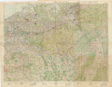
1:250,000 COMPOSITE WALL-MAP NORTHWEST EUROPE. Ordnance Survey Office, Southampton, 1914
Original Item recovered from possibly Australian Corps HQ, probably between the Armistice, 11 November 1918, and June 1919, when the Staff Sergeant R.O.(Bob) Snape was repatriated.Cloth-backed paper. 6 map sheets glued together to form one large wall map of NW Europe, covering from Normandy beaches to Cologne and Paris to Strasbourg.snape collection -
 Marysville & District Historical Society
Letter (Item) - Hand written letter, John William Lindt, 1903
A letter written to Maurice Keppel by John William Lindt in 1903.A letter written to Maurice Keppel by John William Lindt in 1903. John William Lindt was born in Germany in 1845. At 17 he took a working passage to Australia on a Dutch sailing ship. Taking up work as an itinerant piano-tuner, he traveled amongst towns in Victoria and New South Wales before settling in Grafton in 1863 where he became assistant and apprentice to photographer Conrad Wagner. After a brief return to Germany in 1867 Lindt took over management of Wagner’s studio in 1869. He married Wagner’s daughter, Anna on 13 January 1872. Over 1873-1874, using the slow and laborious wet-plate collodion process, John Lindt produced photographs of the local indigenous people both in their environment conducting actual traditional ceremonies in the Clarence River district, and in his studio. Twelve of this series is included in his 1874 album Australian Aboriginals. John Lindt moved to Melbourne in 1876 where he worked for Batchelder & Co. before opening his own opulent studios at number 7 at the top of Collins Street opposite the Treasury, in 1877. John Lindt's business of this period was wide-ranging, and included portraits, records of Melbourne public buildings and streetscapes, the Botanical Gardens, and Port Melbourne. He was a welcome photographer of members of parliament and other Melbourne personalities, their society and cultural life including the theatre, and was known as a ‘rich man’s photographer’ for those whose families he grouped informally on the lawns in front of their mansions, with servants at the rails of the upstairs balconies. He continued with landscape, producing folios Fernshaw and Watt River Scenery, Victoria ( c.1878-82), Scenery on the Ovens and Buckland Rivers, Victoria (c.1878–82) and Lorne, Louttit Bay and Cape Otway Ranges (1883). Sales of his Black Spur scenery amounted to approximately 25,000 copies printed from the original negatives between 1882 and 1892. John Lindt, in collaboration with Nicholas John Caire, produced a tourist booklet on the area around "The Hermitage" in 1913. Maurice Keppel, from Ireland, was one of the first landholders in the newly surveyed town of Marysville in 1864. He and his wife ran the successful Keppel’s Australian Hotel. Two of their sons, John and Jerry, established a farm and opened up the surrounding high country. The Keppel lease was one of the longest held in the high country and the Keppel Family were amongst Marysville's pioneering families.maurice keppel, keppel family, keppel's australian hotel, marysville, victoria, john william lindt, conrad wagner, australian aboriginals, batchelder & co, nicholas john caire, anna lindt -
 Flagstaff Hill Maritime Museum and Village
Book, A Treatise on Surveying
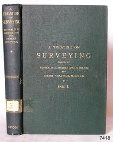
This item is from the ‘Pattison Collection’, a collection of books and records that was originally owned by the Warrnambool Mechanics’ Institute, which was founded in Warrnambool in 1853. By 1886 the Warrnambool Mechanics’ Institute (WMI) had grown to have a Library, Museum and Fine Arts Gallery, with a collection of “… choice productions of art, and valuable specimens in almost every branch and many wonderful national curiosities are now to be seen there, including historic relics of the town and district.” It later included a School of Design. Although it was very well patronised, the lack of financial support led the WMI in 1911 to ask the City Council to take it over. In 1935 Ralph Pattison was appointed as City Librarian to establish and organise the Warrnambool Library as it was then called. When the WMI building was pulled down in 1963 a new civic building was erected on the site and the new Warrnambool Library, on behalf of the City Council, took over all the holdings of the WMI. At this time some of the items were separated and identified as the ‘Pattison Collection’, named after Ralph Pattison. Eventually the components of the WMI were distributed from the Warrnambool Library to various places, including the Art Gallery, Historical Society and Flagstaff Hill. Later some were even distributed to other regional branches of Corangamite Regional Library and passed to and fro. It is difficult now to trace just where all of the items have ended up. The books at Flagstaff Hill Maritime Village generally display stamps and markings from Pattison as well as a variety of other institutions including the Mechanics’ Institute itself. RALPH ERIC PATTISON Ralph Eric Pattison was born in Rockhampton, Queensland, in 1891. He married Maude Swan from Warrnambool in 1920 and they set up home in Warrnambool. In 1935 Pattison accepted a position as City Librarian for the Warrnambool City Council. His huge challenge was to make a functional library within two rooms of the Mechanics’ Institute. He tirelessly cleaned, cleared and sorted a disarrayed collection of old books, jars of preserved specimens and other items reserved for exhibition in the city’s museum. He developed and updated the library with a wide variety of books for all tastes, including reference books for students; a difficult task to fulfil during the years following the Depression. He converted all of the lower area of the building into a library, reference room and reading room for members and the public. The books were sorted and stored using a cataloguing and card index system that he had developed himself. He also prepared the upper floor of the building and established the Art Gallery and later the Museum, a place to exhibit the many old relics that had been stored for years for this purpose. One of the treasures he found was a beautiful ancient clock, which he repaired, restored and enjoyed using in his office during the years of his service there. Ralph Pattison was described as “a meticulous gentleman whose punctuality, floorless courtesy and distinctive neat dress were hallmarks of his character, and ‘his’ clock controlled his daily routine, and his opening and closing of the library’s large heavy doors to the minute.” Pattison took leave during 1942 to 1942 to serve in the Royal Australian Navy, Volunteer Reserve as Lieutenant. A few years later he converted one of the Museum’s rooms into a Children’s Library, stocking it with suitable books for the younger generation. This was an instant success. In the 1950’s he had the honour of being appointed to the Victorian Library Board and received more inspiration from the monthly conferences in Melbourne. He was sadly retired in 1959 after over 23 years of service, due to the fact that he had gone over the working age of council officers. However he continued to take a very keen interest in the continual development of the Library until his death in 1969. The Pattison Collection, along with other items at Flagstaff Hill Maritime Village, was originally part of the Warrnambool Mechanics' Institute’s collection. The Warrnambool Mechanics’ Institute Collection is primarily significant in its totality, rather than for the individual objects it contains. Its contents are highly representative of the development of Mechanics' Institute libraries across Australia, particularly Victoria. A diversity of publications and themes has been amassed, and these provide clues to our understanding of the nature of and changes in the reading habits of Victorians from the 1850s to the middle of the 20th century. The collection also highlights the Warrnambool community’s commitment to the Mechanics’ Institute, reading, literacy and learning in the regions, and proves that access to knowledge was not impeded by distance. These items help to provide a more complete picture of our community’s ideals and aspirations. The Warrnambool Mechanics Institute book collection has historical and social significance for its strong association with the Mechanics Institute movement and the important role it played in the intellectual, cultural and social development of people throughout the latter part of the nineteenth century and the early twentieth century. The collection of books is a rare example of an early lending library and its significance is enhanced by the survival of an original collection of many volumes. The Warrnambool Mechanics' Institute’s publication collection is of both local and state significance. A Treatise on Surveyin Compiled by Reginald Middleton,Osbert Chadwick, & J. Du T. Bogle Publisher: E & F N Spon Ltd Date: 1911 Label on spine with typed text PAT 562.9 MID Pastedown end page has sticker from Corangamite Regional Library Service over a sticker from Warrnambool Mechanics Institute and Free Library warrnambool, shipwrecked-coast, flagstaff-hill, flagstaff-hill-maritime-museum, maritime-museum, shipwreck-coast, flagstaff-hill-maritime-village, shipwrecked-artefact, book, warrnambool mechanics’ institute, pattison collection, warrnambool library, ralph eric pattison, warrnambool city librarian, mechanics’ institute library, victorian library board, warrnambool books and records, warrnambool children’s library, a treatise on surveying, reginald middleton, osbert chadwick, j. du t. bogle -
 Glen Eira Historical Society
Map - CAPLES PLACE SUBDIVISION
This file contains a copy of a map of the CAPLES PLACE SUBDIVISION, undated and author unknown. The map provides the dimensions of roads and allotments in the area, including also handwritten notes from the original document and others written directly onto the copy.land subdivisions, documents, maps, glen eira, caples place, caples place subdivision, land surveys, orrong road, mulgrave road, prahran grove, somerset road, prahran grove, prahran grove, east walk, land allotments, town planning, garden road -
 Glen Eira Historical Society
Article - Caulfield Park
This file has thirteen items. 1/Typed note date and author unknown, titled development in Caulfield Park, describing the statuses commissioned for the park in 1975. 2/Photocopies undated of photographs of two of the statues. 3/Article dated 19/03/1980 in the Southern Cross newspaper about Caulfield Councils frisbee and golf day at the park. 4/Invitation for Mr. and Mrs. Campbell to attend tree planting ceremony at Caulfield Park on 23/10/1988 to commemorate Raoul Wallenberg. 5/Black and white photograph, undated, photographer unknown, of lake and fountain at Caulfield Park. 6/Three colour photographs dated June 1982 of Caulfield park. 7/Photocopy of photograph of War Memorial at Caulfield Park. 8/Leaflet advertising a parade and fair at the park on 25/05/1997. 9/Two black and white photographs, date and photographer unknown, of conservatory at the park after it burnt down, possibly in the 1920’s. 10/Friends of Caulfield Park newsletter dated July 2007 concerning the council’s plans for the park. 11/Article dated 19/10/2011 from Melbourne Weekly Bayside about the conservatory and its future, includes photograph. 12/Article dated 07/05/2013 in the Glen Eira Leader concerning the council’s plans for the conservatory. Includes dot points that original glasshouse (ex-Ripponlea) destroyed by fire in 1977 and replaced by existing hothouse. 13/Article dated 23/07/2013 from Glen Eira/Port Phillip Leader about public society survey concerning the conservatory’s future.caulfield park, north caulfield, balaclava road, caulfield city council, cannizzo phillip, statues, sculpture, hawthorn road, meserow hale, campbell jack, campbell mrs., braun emil, huppert michelle, wallenberg raoul, fountains, parks and reserves, monuments and memorials, parades and processions, festivals and celebrations, greenhouses, conservatories, catherine street, st aloysius school hall, friends of the caulfield park., caulfield park pavillion, pavilions, sportsgrounds, playing fields, playgrounds, glen eira council, wilde david, pilling neil, lipschutz michael, rippon lea mansion, magee jim, lobo oscar, sounness thomas -
 Federation University Historical Collection
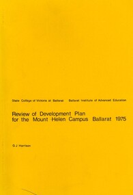
Book, G.J. Harrison, Review of Development Plan for the Mount Helen Campus Ballarat, 1975, 1975
In 1967 the site for the Mt Helen Campus was selected and purchased to permit the tertiary division of the Ballarat School of Mines - the Ballarat Institute of Advanced Education (BIAE) to move from the crowded Lydiard Street site, to occupy new accommodation designed for the purpose. The brief given to the campus master planners called for the creation of a modern, attractive, efficient and stimulating concept. It called for careful landscaping and enhancement of the environment, but above all it demanded flexibility for an unpredictable future. During 1974 major new directions were made at Government level quite beyond the scale of change that had been foreseen in 1967. This change was to be that of merging BIAE and the State College of Victoria at Ballarat (formerly Ballarat Teachers' College) into one large new college of broadened scope. By the end of 1974 joint committees representing the still separate, autonomous Councils of the two institutions had agreed on the means of achieving the merger to the extent that a new brief as prepared and given to G.J. Harrison, one of the original master planners who had been chosen to revise the plan to meet the new needs. Yellow soft covered book of 63 pages reviewing the Development Plan for Mount Helen Campusuniversity of ballarat, ballarat institute of advanced education, mount helen, master plan, ballarat college of advanced education, mb john, ian gordon, pdf, development plan, mount helen campus, g.j. harrison, state college of victoria ballarat, m.b. john, canadian valley, aquinas college, site survey, land use zones, landscaping, campus plan, mt helen campus -
 Federation University Historical Collection
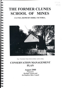
Book, The Former School of Mines Clunes Conservation Management Plan, 2000, 08/2000
The Clunes School of Mines was a campus of the Ballarat School of Mines. The conservation plan was prepared for Hepburn Shire Council and Heritage Victoria to guide the future management of the former Clunes School of Mines in Service Street, Clunes, The building was opened in February 1892 as the Clunes branch of the Ballarat School of Mines, and ceased operating in June 1893.Spiral bound black and white copy of the Conservation Plan for the Clunes School of Mines. Contents include the history, chronology development, context of the building and site, current and past function of the building, original fabric, impact of later alterations, condition of the building, statement of significance, conservation action plan, caring for the site, collecting and keeping information, structural engineers Report, Department of Lands Survey 1955, Memorandum of Agreement 1956.ballarat school of mines, clunes school of mines, australian native association, ana, australian native association clunes branch, eygelaar inner spring mattress factory, clunes infant welfare centre, clunes angling club -
Federation University Historical Collection
Map, Creswick Gold Field Map, 1981
A fragment of the original 1880 map is also held in the collection. See 116Rectangular geological map with brown paper strip on top edge with 4 holes on top edge. Scale is 40 chains to one inch.Geologically and topographically surveyed by Ferdinand M Krause. Lithographed by R. Shepherd. Printed by J. Finnie. Mining Department, Melbourne. Preprinted with additional shaft and lead detail. F. D. Atkinson, Government Printer 1981creswick, krause, surveyor, smeaton, spring hill, tourello, ascot, dean, bullarook, gold fields, gold -
Federation University Historical Collection
Document - Reports, Martin Westbrooke, Nanya Station
Nanya Station, owned and managed by the University of Ballarat (now Federation University Australia), was purchased with assistance from the Department of Environment and Heritage Government Caring for our Country program. Nanya Station is located in the Scotia country, west of the Darling Ana-Branch in far western New South Wales and consists of the Nanya Western Lands Pastoral Lease 3281 – Perpetual Leasehold Lot 1244 in Deposited Plan 762778, Parish of Winnebaga, County of Tara and part of Lot 1242 County of Windeyer. Nanya is within the tribal area of the Danggali Aboriginal people, a sub-group of the Barkindji. Many Aboriginal sites have been recorded adjacent to major rivers in the region providing evidence that these areas supported a large population. The Scotia region has one of the shortest stock grazing histories of western NSW. Along with five other Scotia properties, Nanya was created as a pastoral lease in 1927. The first European settlement on the land followed exploration of the area by Sturt and Eyre. In 1854, the Lake Victoria lease which encompassed this area comprised 465,000ha.included Scotia blocks 1, 2, 3 and 4, Amoskeag and Winnebaga which formed the area known as the Scotia. It was described as a region of thick mallee scrub, interspersed with bluebush flats and Belah woodland. In the 1920s artesian water was found and the dry Scotia country was surveyed and divided into six Homestead leases allocated by ballot (Withers 1989). All properties were approximately 30,000ha, with a recommended stocking level of 3,000 sheep. Winnebaga (renamed Nanya) was taken up by Gordon Cumming. He initially dug a dam near the southeast corner of the property. A larger ground tank and rudimentary dwelling at the site of the present complex was later established. An adjacent area was cleared and cropped to provide feed for the horses used in digging the earth tanks. The ruins of the original building are located between the shearing shed and Homestead Tank. A cottage was built in the 1930s and a more substantial Red Gum framed homestead in the early 1950s. The lease was held by Mr Gordon Cumming until 1984 when it was purchased by Mr Norm Scadding as an extension to the adjacent lease, Belvedere. It was sold in 1995 to Mr Rob Taylor of Waikerie then in 1999 to BeMax Pty. Ltd., a sand mining company. These last three owners all permitted use of the property by the University for teaching and research. The Centre for Environmental Management at the University of Ballarat had been involved in studies of flora and fauna in western New South Wales since 1988. Studies became concentrated on the Scotia region with its variety of intact ecosystems due to a short pastoral history. Of particular significance is a system of natural salt lakes of which the most extensive is the Scotia Discharge Complex located on Nanya Station. An extensive vegetation survey of the Scotia region Westbrooke et al. 1998) highlighted the significance of the area both in terms of the range of communities in relatively intact condition and the occurrence of species and communities of restricted distribution. Nearly 400 species were recorded of which nine had either not previously been recorded or have restricted distribution in western NSW. Twenty-two plant communities occur on Nanya Station of which two, Halosarcia lylei low open shrubland and Hemichroa diandra/Halosarcia/Frankenia low open shrubland, are dominated by species not previously recorded from NSW. H. lylei and Acacia loderi shrublands are listed as endangered under the NSW Threatened Species Conservation Act. As noted, the area has a relatively short grazing history and, due to the presence of large areas of mallee with a Triodia understorey and restricted water supplies, stocking rates have been low. The diversity of ecosystems in relatively intact condition and extensive areas of old growth mallee made Nanya a highly significant refuge for biological diversity. This factors led to the purchase of Nanya Station by the University of Ballarat in 2004 with the assistance of the Department of Environment and Heritage for the purposes of conservation, research and education. In 2010 the southern paddocks of Nagaella Station (10,000ha.) which lie along the northern boundary, were purchased with the assistance of Lower Murray Darling Catchment Management Authority and added to the Nanya lease to provide complete protection for the communities of the Nanya Discharge Complex and further high quality Malleefowl habitat. Four digital reports documents relating to Federation University's Nanya Station, Western New South Walesnanya station, scotia country, pastoral lease, winnebaga county, darling ana-branch, martin westbrooke, environmental education, nagaella station, lower murray darling catchment management authority, conservation research education, ian gribble, pat prevett, ian henderson, danggali -
Federation University Historical Collection
Map, Town of Buninyong, 1927, 09/1927
The date of this map is September 1927 revised from the original 1910 map. Buninyong was created a district on 09 July 1858, proclaimed a Shire on 16 February 1864, and the Buninyong Borough united on 01 October 1915.Township plan of the Town of Buninyong showing government roads and crown allotments. Earlier detail pencilled on (commercial buildings, etc) appears to be from an 1850 survey. Scale: 4 chains to 1 inch (1:3168)buninyong, map, buninyong botanical gardens, tannery dam, buninyong reservoir, chapel school, rev. hastie -
 Flagstaff Hill Maritime Museum and Village
Award - Certificate of Service, F. W. Strahle, James Patten, 23-08-1907
This certificate acknowledges 21 years of service given by James Patten, one of the original 1859 Lifeboat Warrnambool as a boatman and bowman. At the time, all retiring Volunteer lifeboatmen were honoured with this award. It was made as a lithograph that was created by F. W. Strahle at the request of the Department of Lands & Survey, Melbourne, Victoria. During his time of service, James Patten was awarded a medal and certificate by the Royal Humane Society of Australasia for his bravery. Patten and his friend Joseph Lowe, who couldn't swim, were with their friend James Ferrier in a boat on the Hopkins River, Warrnambool, when their boat capsized. Ferrier made it to shore, and Patten tried unsuccessfully to hold onto Lowe and bring him to shore. The event occurred on 18th April 1890. The images on the Certificate show a collage of rescue events performed by the lifesavers; a shipwreck rescue in progress, lifeboat conveying five boatmen using two oars each, and a bowman standing at the bow, a linesman wearing a life jacket and holding a rescue line, a lifesaver ring with images of three sailing ships inside it, a shipwreck near shore, a woman and girl in shallow water, a rescue using a breeches buoy on the lifeline, two rescuers walking towards the survivor, rescue crew wearing waterproof clothing, a rocket machine with a pulley to bring the survivor in a breaches buoy to shore, and a rescue crew member holding a flare. Volunteers at the time received a small payment, or 'retainer'', for their practices and a payment of gratitude for the rescues they attended. Across the years between 1856 to 1979 the combined service in Victoria saved 260 lives. Amazingly, some of the volunteers could not even swim.This certificate shows the State and Local Government's appreciation for the years of service spent by in the endeavour to save lives in peril in and on the local waters in the early 20th Century. The lithographed design depicts the many skills and services performed by the lifesavers of the era.Certificate of Service, unframed, awarded to James Patten on 23rd August 1907, recognising his 21 years of service with the original Warrnambool Life Boat Service as a Boatman and Bowman. Certificate is on rectangular, cream paper, lithographed design, printed and handwritten. Letterhead with the Royal Coat of Arms of the United Kingdom and a French motto. Images depict lifesaving crew, lifeboat, rescue equipment and a rescue in progress. The border is waves inside of frame of looped rope. Signatures of Commissioner of Public Works, Secretary of Public Works, and Engineer in charge of Ports and Harbours, Melbourne. Printed from a lithograph produced by F.W. Strahle on 23rd June 1907.MOTTO: "Dieu Droit Et Mon, Ni Soit Qui Mal y" TREXT: "Certificate granted to James Patten as a mark of appreciation of his esteemed services of 21 years as Boatman and Bowman connected with the Departmental Life-Boat service at Warrnambool - dated the 23rd day of August 1907." SIGNATURES: [Commissioner of Public Works], [Secretary of Public Works], [Engineer in charge of Ports and Harbours Melbourne] "Lithographed at the Dept of Lands & Survey - Melb/ by F.W. Strahle, 23.6.07"flagstaff hill, warrnambool, flagstaff-hill, maritime museum, maritime village, shipwreck-coast, flagstaff hill maritime museum & village, james patten, life-saving, lifesaving, rescue, bravery, drowning, joseph lowe, james ferrier, hopkins river, boat accident, certificate of service, 1890, 1907, bowman, boatman, departmental life-boat service, life-boat service, lifeboat service, august 1907, commissioner of public works, public works, ports and harbours melbourne, lands & survey melbourne, f w strahle, lithograph, 1856-1979, 260 lives saved, victorian volunteers, lifeboatmen, retired lifeboatmen -
 Flagstaff Hill Maritime Museum and Village
Book, The Logbooks of The Lady Nelson, 1915
This hardcover book, The logbooks of the 'Lady Nelson' : with the journal of her first commander, Lieutenant James Grant, R.N., by Ida Lee (Mrs Charles Bruce Marriott) was published over 100 years after the Lady Nelson arrived in Australia to navigate and survey this ‘new colony’. Included in the book are sixteen charts and illustrations from the originals in the Admiralty Library, showing the surveyed land and water. The transcribed Contents, below, summarise the trips of the Lady Nelson during this time. Book’s Content PLUS text of the Chart of ‘Part of Bass Strait’ - Chapter 1: The Lady Nelson built with centreboards. Her voyage to Sydney under James Grant. The first ship to pass through Bass Strait. - Chapter 2: Returns to explore the Strait. Her visits to Jervis Bay and to Western Port in 1801 - Chapter 3: Colonel Paterson and Lieutenant Grant survey Hunter River - Chapter 4: Murray appointed commander of the Lady Nelson. His voyage to Norfolk Island. - Chapter 5: Murray’s exploration of Bass Strait. - Chapter 6: Discovery of Port Phillip. - Chapter 7: The Lady Nelson in company with HMS Investigator examines the North-Eastern shores of Australia. - Chapter 8: The French ships in Bass Strait. The founding of Hobart. - Chapter 9: Symons succeeds Curtoys as commander of the Lady Nelson. His voyages to Tasmania, Port Phillip and New Zealand. - Chapter 10: The Lady Nelson in Tasmania. The founding of Port Dalrymple. - Chapter 11: The Estramina is brought to Sydney. The Lady Nelson visits Norfolk Island and Port Dalrymple. - Chapter 12: Tippahee and his four sons are conveyed to New Zealand in the Lady Nelson. - Chapter 13: The Lady Nelson accompanies HMS Tamar to Melville Island. - Chapter 14: The loss of the Lady Nelson Text included with the ‘Chart of Bass Strait’ … “Part of Bass Strait, including the discoveries made by Acting Lieut. J. Murray, commander of His Majesty’s armed surveying vessel Lady Nelson, between November 1801 and March 1802. By command of His Excellency Governor King.” “This chart, which bears Murray’s autograph, shows his explorations of Western Port, Port Phillip and King Island. It should be noted that Flinders Island is named Grand Capuchin. This is one of the charts referred to as "unfortunately missing” in the Historical Records of N.S. Wales, vol. iv. P. 764” The story of the Lady Nelson In 1798 the British Admiralty ordered a cutter of 60 tons to be built along the design of the armed cutter Trial that was developed by Captain John Schanck, with three sliding keels or centreboards that could be individually raised and lowered, for use on the River Thames. The new cutter was to be named Lady Nelson. Philip Gidley King, prior to taking up his appointment as third Governor of the colony of New South Wales, was in England at the time of the Lady Nelson’s fit-out and was aware of the need for such a ship for survey work in the colony in New South Wales. He convinced Captain Schanck, the Commissioner of Transport in England, to construct and rig the Lady Nelson as a brig rather than a cutter, keeping the feature of the three sliding keels, which would be very useful for mapping in shallow waters. The new Lady Nelson was launched at Deptford, England on the River Thames in November 1798, with the official commission to discover and survey the unknown parts of the coast of New Holland (Australia) and establish British sovereignty over the continent. The Lady Nelson sailed from Portsmouth, England on March 1800 under the command of Lieutenant James Grant. She carried an armament of two original and four extra brass carronade carriage guns and set sail as part of a convoy heading to Port Jackson, in New South Wales, New Holland. After a while she continued to sail on her own. Her journey was troubled with problems at times; damaged and broken keels, troublesome crew and leaking topsides between the waterline and the deck due to poor seals. She arrived at the Cape of Good Hope in July and waited for the winter to pass to avoid the strong winds of the ‘Roaring Forties’. While at the Cape, Grant received a despatch to travel to Port Jackson via the newly discovered Bass Strait, rather than the usual route via the tip of Van Diemen’s Land (Tasmania). This also gave him the opportunity to survey the strait on the way. He departed the Cape in October and in December he made his first sighting of New Holland near Mount Gambier in what is now South Australia. A report by Ecclestone in 2012, ‘The Early Charting of Victoria’s Coastline’, mentions that Grant charted and named Capes Banks and Northumberland, and sighted inland hills that he named Mt Gambier and Mt Schanck, the latter after the designer of his ship. Grant then reached the south-western shores of what is now Victoria on 3-4 December 1800, and from Cape Bridgewater he examined the coast eastward to Cape Patton. Although he had not continuously sighted the coast in the vicinity of Port Fairy and Warrnambool, the western part of Victoria became known as Grant’s Land. The Lady Nelson continued eastward and passed through Bass Strait, becoming the first vessel to reach the east coast of New Holland from the west, and arrived at her destination of Port Jackson later in December 1800. Grant, in the Lady Nelson, then left Port Jackson and began survey work. He discovered Port Phillip on Victoria’s coast and explored King Island, he helped establish the first European settlement in Tasmania on the Derwent River, and Port Dalrymple, Newcastle and Port Macquarie. He made several trips from Norfolk Island to Hobart Town. Governor Macquarie sailed on with him to Van Diemen’s Land for a tour of inspection in 1811. Grant helped establish the first settlement on Melville Island in Northern Australia. The Lady Nelson was used to transport cargo, civilians and convicts and to source pigs from Timor. In February 1825 the Lady Nelson sailed again for Timor and never returned. One report said that “Every soul on board, we regret to state, was cruelly massacred, and the hull of the vessel was seen some time after with the name painted on her stern.” The hull was sighted on the island of Babar, which is almost 200 kilometres east of Timor. This particular copy of the book ... This item is from the ‘Pattison Collection’, a collection of books and records that was originally owned by the Warrnambool Mechanics’ Institute, which was founded in Warrnambool in 1853. By 1886 the Warrnambool Mechanics’ Institute (WMI) had grown to have a Library, Museum and Fine Arts Gallery, with a collection of “… choice productions of art, and valuable specimens in almost every branch and many wonderful national curiosities are now to be seen there, including historic relics of the town and district.” It later included a School of Design. Although it was very well patronised, the lack of financial support led the WMI in 1911 to ask the City Council to take it over. In 1935 Ralph Pattison was appointed as City Librarian to establish and organise the Warrnambool Library as it was then called. When the WMI building was pulled down in 1963 a new civic building was erected on the site and the new Warrnambool Library, on behalf of the City Council, took over all the holdings of the WMI. At this time some of the items were separated and identified as the ‘Pattison Collection’, named after Ralph Pattison. Eventually the components of the WMI were distributed from the Warrnambool Library to various places, including the Art Gallery, Historical Society and Flagstaff Hill. Later some were even distributed to other regional branches of Corangamite Regional Library and passed to and fro. It is difficult now to trace just where all of the items have ended up. The books at Flagstaff Hill Maritime Village generally display stamps and markings from Pattison as well as a variety of other institutions including the Mechanics’ Institute itself. RALPH ERIC PATTISON Ralph Eric Pattison was born in Rockhampton, Queensland, in 1891. He married Maude Swan from Warrnambool in 1920 and they set up home in Warrnambool. In 1935 Pattison accepted a position as City Librarian for the Warrnambool City Council. His huge challenge was to make a functional library within two rooms of the Mechanics’ Institute. He tirelessly cleaned, cleared and sorted a disarrayed collection of old books, jars of preserved specimens and other items reserved for exhibition in the city’s museum. He developed and updated the library with a wide variety of books for all tastes, including reference books for students; a difficult task to fulfil during the years following the Depression. He converted all of the lower area of the building into a library, reference room and reading room for members and the public. The books were sorted and stored using a cataloguing and card index system that he had developed himself. He also prepared the upper floor of the building and established the Art Gallery and later the Museum, a place to exhibit the many old relics that had been stored for years for this purpose. One of the treasures he found was a beautiful ancient clock, which he repaired, restored and enjoyed using in his office during the years of his service there. Ralph Pattison was described as “a meticulous gentleman whose punctuality, floorless courtesy and distinctive neat dress were hallmarks of his character, and ‘his’ clock controlled his daily routine, and his opening and closing of the library’s large heavy doors to the minute.” Pattison took leave during 1942 to 1945 to serve in the Royal Australian Navy, Volunteer Reserve as Lieutenant. A few years later he converted one of the Museum’s rooms into a Children’s Library, stocking it with suitable books for the younger generation. This was an instant success. In the 1950’s he had the honour of being appointed to the Victorian Library Board and received more inspiration from the monthly conferences in Melbourne. He was sadly retired in 1959 after over 23 years of service, due to the fact that he had gone over the working age of council officers. However he continued to take a very keen interest in the continual development of the Library until his death in 1969 This book about the logbooks of the Lady Nelson is locally significant for its association with the brig Lady Nelson, in which Lt. James Grant made the first documented European discovery of the area later known as Warrnambool in December 1800. This book is also nationally significant for its association with Grant in the Lady Nelson being the first to sail from west to east through Bass Strait, opening up a shorter, faster route to the colony of Port Jackson rather than going all the way south around Van Diemen’s Land. The book is nationally significant for its contents of the logbooks of the journeys of the Lady Nelson under various commanders and the copies of the charts created from the surveyed information and the new land of Australia was discovered. This book is also significant for its association with the full-size non-sailing replica of the Lady Nelson from Mount Gambier’s visitor centre, which was restored by Flagstaff Hill’s Master Boat Builder in Warrnambool in 2012, and with a ship mode of the Lady Nelson in our Collection The Pattison Collection, along with other items at Flagstaff Hill Maritime Village, was originally part of the Warrnambool Mechanics' Institute’s collection. The Warrnambool Mechanics’ Institute Collection is primarily significant in its totality, rather than for the individual objects it contains. Its contents are highly representative of the development of Mechanics' Institute libraries across Australia, particularly Victoria. A diversity of publications and themes has been amassed, and these provide clues to our understanding of the nature of and changes in the reading habits of Victorians from the 1850s to the middle of the 20th century. The collection also highlights the Warrnambool community’s commitment to the Mechanics’ Institute, reading, literacy and learning in the regions, and proves that access to knowledge was not impeded by distance. These items help to provide a more complete picture of our community’s ideals and aspirations. The Warrnambool Mechanics Institute book collection has historical and social significance for its strong association with the Mechanics Institute movement and the important role it played in the intellectual, cultural and social development of people throughout the latter part of the nineteenth century and the early twentieth century. The collection of books is a rare example of an early lending library and its significance is enhanced by the survival of an original collection of many volumes. The Warrnambool Mechanics' Institute’s publication collection is of both local and state significance. The Logbooks of The Lady Nelson Author: Ida Lee ( Mrs Charles Bruce Marriott) Publisher: Grafton & Co Date: 1915Label on spine with typed text RA 910.994 LEE Inside front cover has a sticker that reads Warrnambool Mechanics Institute and Free Library shipwrecked-coast, flagstaff-hill, warrnambool, flagstaff-hill-maritime-museum, maritime-museum, shipwreck-coast, flagstaff-hill-maritime-village, shipwrecked-artefact, book, warrnambool library, warrnambool mechanics’ institute, warrnambool city librarian, mechanics’ institute library, victorian library board, warrnambool books and records, warrnambool children’s library, great ocean road, the logbooks of the lady nelson, ida lee, mrs charles bruce marriott, captain john schanck, sliding keels or centreboards, lady nelson, british brig hms lady nelson, lieutennant james grant, bass strait discovery, surveying king island and port phillip bay, philip gidley king, survey map