Showing 147 items
matching parapets
-
 Bendigo Historical Society Inc.
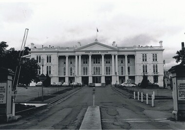
Photograph - ANNE CAUDLE CENTRE, 1995
Black and white photo: 3 storey rendered building with parapet. 8 columns at front. Driveway with grass and garden beds each side. Hinged traffic barrier at front left. Motor vehicles in front of building. In image on building ' Anne Caudle Centre' on back in grey lead pencil O 24. ( Noelene Wild 7.2000 Photo, Peter Hyett 1995. Anne Caudle Centre, main entrance from Barnard Street. ( formerly Home and Hospital for the Aged, originally Bendigo Benevolent Asylum )Peter Hyattbuildings, hospital, anne caudle centre -
 Bendigo Historical Society Inc.
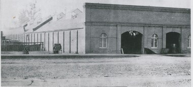
Photograph - BRICK BUILDING, 1861
black and white photo: brick bulding . Commercial ? Brick front with parapet , 2 arched doorways,3 arched windows, building frontrs street. 2 doors to underground cellar open. Windows barred, Side wall has brick buttresses. Galvanised iron roof with 6 glass skylights and louvred ventilator. Rear of Batchelder's cart to left. Male seated near cart. 3 males in timber pens rear of Batcherlders cart to left. Raised footpath. Protective stanchions at entrance door. On back in pencil ' not known' ' 13'Batchelderbuildings, commercial -
 Kew Historical Society Inc
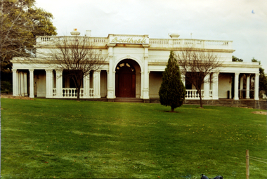
Photograph, Façade of ‘Southesk', Cotham Road, 1970
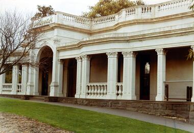
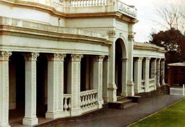
Colour enlargement of a photograph (slide) of Southesk (formerly Ordsall) in Cotham Road, Kew (demolished 1970).Colour photograph of the front lawn and façade of ‘Southesk’ (formerly ‘Ordsall’, built for John Halfey in 1882). The house was located on the corner of Cotham Road and Charles Street, Kew. The Italianate mansion was built in the Renaissance villa style on a bluestone plinth. Two balustrades surrounded the parapet of the roof and ran between the groups of pillars on either side of the entrance porch. The verandah was tiled and wide and Corinthian columns supported its roof. When the house passed into the hands of the City of Kew in 1948, the landscaping and formal flower beds were removed and replaced by lawns.The house was demolished in 1970.david carnegie, john halfey, southesk - cotham road - kew (vic), ordsall - cotham road - kew (vic) -
 Kilmore Historical Society
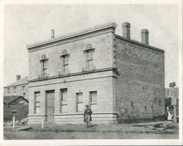
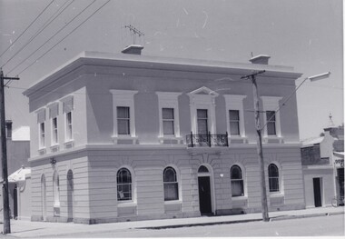
Photograph, Oriental Bank Corporation, 1866
This photograph was most likely taken for the 1866 Intercolonial Exhibition in Melbourne.25cm x 20cm black and white reproduction of a photograph of the Oriental Bank Corporation, 7 Sydney Street Kilmore, from the State Library of Victoria. Double storey building with decorative parapet along roofline, wrought iron balconets at upper storey windows, decorative hood molds above windows, name of bank in stone under ground floor cornice, a man standing on path in front of bank. Woman standing at back of building in shadow. A sign on post at back of building reads: Land for Sale Apply to W. Grace Solicitor Kilmore.Printed on back: REPRODUCTION RIGHTS RESERVED Copied by State Library of Victoria Tenders called for erection of this building in March 1864.banks, 19th century -
 Charlton Golden Grains Museum Inc
Photograph, Victoria Hall, Armstrong St Charlton c. 1960, c.1960
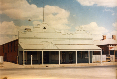
Victoria Hall, Armstrong St Charlton was built for E. Miles in 1884. Sid Rosewall's house is on the right. This photo taken c. 1960.Colour photograph of a single storey, triple fronted red brick building. The front of the building is painted. There are double doors for the main entrance and three single doors - one to the left and two to the right of the main doors. There is a large, ornamental parapet wall on the front of the building with a flag pole. A wide verandah runs the length of the front of the building with a pitched section over the main entrance. The LH side of the building is unpainted and has four windows high on the wall. A red brick building is partially visible on the RH side of the photo. It has two chimneys and iron roof.e. miles, s. rosewall, victoria hall, armstrong street, charlton, halls -
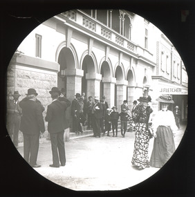
 Bendigo Historical Society Inc.
Photograph - BEEHIVE BUILDING
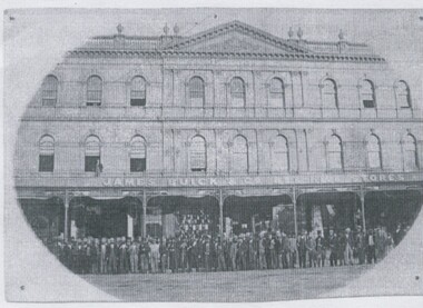
Black and white photocopy of photograph on board. Oval shaped image. Beehive Building. Large group of men standing at front. Inscriptions: In image - on verandah 'James Buick & Co. Beehive Stores'. On building below parapet 'Beehive Chambers, James Buick & Co, Beehive Chambers'. On windows 'Bee Hive, Billiard Saloon'. 'H? Birch, Legal Manager'. 'CW Bell, Legal Manager'. History of object: James Lerk 2000 'James Buick's Beehive Store & Mining Exchange, Pall Mall Bendigo. Legal Managers staff and speculators are standing on the roadway' Photographed for Bendigo Advertiser 11.1.2001.buildings, commercial, beehive building -
 Bendigo Historical Society Inc.
Photograph - A.W.PULFER MOTORS PTY LTD: CORNER OF MUNDY AND HARGREAVES STREET, BENDIGO
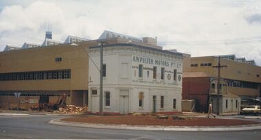
Black and white photograph, rendered brick 2 storey building, parapet, single storey section at back with tall square brick chimney. Includes bus shelter, electricity pole with transformer. 2 small trees plnated in nature strip. Rocks around trees. ' The Technical and Further education 'Ted Thompson'building under construction C 1982. In the centre is the former Royal Princess Hotel (now shown as A. W. Pulfer Motors), on the corner of Mundy and Hargreaves Streets which was demolished in February 1983. Specimen Cottage is to the right. ' On back '11' Ward/A/FSP/1204' 'O'organization, education, tafe college -
 Kew Historical Society Inc
Photograph, Façade of ‘Southesk', Cotham Road, 1970
Colour enlargement of a photograph (slide) of Southesk (formerly Ordsall) in Cotham Road, Kew (demolished 1970).A colour photograph of the façade of ‘Southesk’ taken at an oblique angle. Formerly known as ‘Ordsall’, the house was built for John Halfey in 1882 on the corner of Cotham Road and Charles Street. The Italianate mansion was built in the Renaissance villa style on a bluestone plinth. Two balustrades surrounded the parapet of the roof and ran between the groups of pillars on either side of the entrance porch. The verandah was tiled and wide and Corinthian columns supported its roof. When the house passed into the hands of the City of Kew in 1948, the Council used it for a kindergarten, an elderly citizen centre and as a home for the Leo Baeck Centre. The house was demolished in 1970.david carnegie, john halfey, southesk - cotham road - kew (vic), ordsall - cotham road - kew (vic) -
 Kew Historical Society Inc
Photograph - Façade of ‘Southesk', Cotham Road, Stewart West, 1970
Colour enlargement of a photograph (slide) of Southesk (formerly Ordsall) in Cotham Road, Kew (demolished 1970).A colour photograph of the façade of ‘Southesk’ taken at an oblique angle. Formerly known as ‘Ordsall’, the house was built for John Halfey in 1882 on the corner of Cotham Road and Charles Street. The Italianate mansion was built in the Renaissance villa style on a bluestone plinth. Two balustrades surrounded the parapet of the roof and ran between the groups of pillars on either side of the entrance porch. The verandah was tiled and wide and Corinthian columns supported its roof. When the house passed into the hands of the City of Kew in 1948, the Council used it for a kindergarten, an elderly citizen centre and as a home for the Leo Baeck Centre. The house was demolished in 1970.david carnegie, john halfey, southesk - cotham road - kew (vic), ordsall - cotham road - kew (vic) -
 The Beechworth Burke Museum
Photograph, Saunders, Unknown
The photograph depicts the two-storey building of the Bank of Victoria which was built in 1858 and was replaced in 1867 after a fire destroyed the original building. The branch had originally opened under John Farran in 1856 before the office building was erected in Beechworth. The building was located on the corner of Ford and Camp streets and embodied the dignified appearance of Beechworth during the mid-1800s due to the building's features. The Bank of Victoria was designed by "Smith and Watts" and built from white brick and render, which cost three thousand and seven hundred pounds to construct. The building was inspired by a formal Italian villa, including square-headed windows, cornices, and a parapet. The ground floor consisted of banking chambers, a strong room, and servants' quarters. The residential quarters were located on the second floor.The photograph is significant as it depicts not only depicts a building of importance to the town of Beechworth but it also shows aesthetic significance due to the style it was built in. As the Bank of Victoria was constructed in the classic Italian style, it exemplifies the classic quality and refined manner of this architectural style. This building style represents the image Beechworth held for itself at that time, which was a sophisticated and distinguished town.Black and white rectangular photograph printed on paper.Reverse: 23/80 / Beechworth / (Indecipherable) / Banking to (Indecipherable) / Sydney / “Bank of Victoria” / BMM 8692.1 / [Stamped: ILFORD]bank of victoria, beechworth, banks, beechworth bank, 1858, 1867, ford street, camp street, victoria, john farran, smith and watts, italian architecture, italian style building, brick building, brick, banking, money, fire, building destroyed -
 Federation University Historical Collection
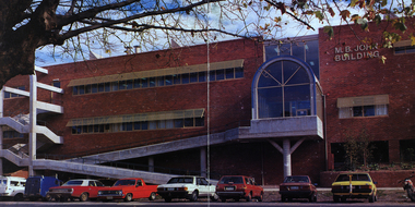
Photograph - black and white, Clare Gervasoni, Ballarat School of Mines M.B. John Buildings, 2016, 08/09/2016
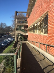
The M.B. John Building (Building K), a three storey, face red brick, restrained Late Twentieth Century International styled building with an elongated, cuboid form (defined by the parapeted facades) that is offset by projecting exposed concrete framed, round‐arched entrance and stair wells on the east (Albert Street) elevation (the centrally located entrance breaking the brick façade with glazing). The facades are also characterised by banks of aluminium framed, horizontal ribbon windows, which wrap around the building corners. Metal shades project beyond the windows, while post‐supported bullnosed verandahs and hoods and projecting concrete stairs are other features. On the west elevation, the cuboid façade is punctuated by projecting curved concrete and glazed, elongated bays at first floor level. (David Rowe/Wendy Jacobs)Colour photograph of a red brick building on Albert Street. It was build to house trade workshops and Ceramics at the Ballarat School of Mines. m.b. john, m.b. john building, ballarat school of mines -
 Kew Historical Society Inc
Photograph - Lalla Rookh : 41 Fellows Street, Progress Press, 1978
The National Trust (Victoria) citation on the Heritage Victoria Database describes Lalla Rookh as charming and rare example of a substantial domestic building from the depths of the depression of the 1890s. It was Classified by the Trust on 22/04/1971. The first Kew Urban Conservation Study established that the house was built in 1897 for John Duncan, civil servant. By 1910 William Robert Frayne, chemist, had purchased the property. When the building was listed by the National Estate the building was described as: '... Single-storied, the symmetrical, stuccoed house features a central porch with an arched opening and pedimented consoles and a bull-nose verandah which returns down both sides and is constructed with cast iron columns and friezes. A balustraded parapet crowns the main walls of the house. The encaustic tiled verandah is distinctive.'"Lalla Rookh", 41 Fellows Street, Kew, is of architectural interest as a representative example of a villa house of the period and also forms pan of the townscape of Kew. In a late version of Boom Style Classicism, the basically modest and conventionally planned house is proportioned to emphasise the porch and heavy balustrade, contrasting with the verandah and plain wall surfaces. The parapet may have had urns originally. The encaustic tiled verandah is of note. ... Of local significance.'Photographic print positive of the facade of Lalla Rookh at 41 Fellows Street, Kew.lalla rookh, houses -- fellows street -- kew (vic.), boom style architecture, architecture -- melbourne -- 1890s -
 Bendigo Historical Society Inc.
Photograph - VIEW POINT HOTEL: BENDIGO
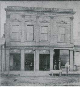
Black and white photo: View Point Hotel, Charing Cross, Bendigo. 2 storey rendered building with parapet. 4 rectangular windows at top. 3 large windows and doorway at bottom. Portion of single storey building at left with corrugated roof verandah. At right, single storey building without verandah. At front, slab lined drain, wooden trough at front with horse. 2 males standing in doorway. Inside building at bar, 1 male, 1 female behind bar. Lamp at front centre. In image: M. Langridge's/View Point Hotel/ Imperial Fire Insurance co./Office/Gilles & Co/Stock and Share brokers. ' Williams' on back in pencil '15'.batchelderbuildings, hotel, view point hotel -
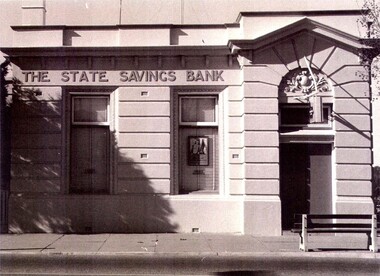 Wodonga & District Historical Society Inc
Photograph - State Bank of Victoria, Wodonga
The Title for the land on which this building stands was granted on 27 August 1857 and the land was bought by Keith Field and A. Maitland. It stood on 1 / 2 acre of land with 250 lengths down South Street and 200 lengths along Sydney Road. The 1 / 2 acre block on the northern side was also purchased by the same buyers. The State Savings Bank was built in 1915, just three years after the State Savings Bank of Victoria was established. It was branch number 731. The building served as a bank until about 1970. It is now owned and used as an office by a local law firm. It is a single storey rendered masonry building with a parapet concealing the roof. Key features of the High Street facade are horizontal bands of masonry, timber windows outlined with moulded details and ornamentation accentuated the door. A more modern branch was opened in a more central location in HIghs Street. The State Bank of Victoria was taken over by the Commonwealth Bank in 1990. These images record the premises of a bank which served the Wodonga community and businesses for many years.3 photos of the State Bank of Victoria in High Street Wodonga at various points in its history.state bank, wodonga businesses, financial institutions wodonga -
 Bendigo Historical Society Inc.
Photograph - ABBOTT & CO BOOT AND SHOE MANUFACTURERS, c.1900
Sepia toned photograph of two story building. Cast iron supports to verandah and balcony. Ornate cast iron trim. New Times sign on parapet. Various sale signs on windows and front doors. Hitching post? In front of shop. Bags of grain, two males, 1 femal figures, four adolescents in front of building. Brick gutter. Wooden case on right. 'Abbott's & Co. Pall Mall Bendigo Boot and Shoe Store' . Check directories for dates of occupation. James Lerk 17/12/1999. History of object: The very flamboyant front for Abbott & Co Boot and Shoe Manufacturers. Abbotts conducted a tannery at Sheepwash - a wonderful example of an industry 'adding'. Photos. C1900. James Lerk caption.buildings, commercial, abbotts boot & shoe manufacturers -
 Glen Eira Historical Society
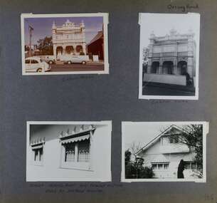
Album - Album page, Orrong Road, Circa 1972
... parapets ...This photograph is part of the Caulfield Historical Album 1972. This album was created in approximately 1972 as part of a project by the Caulfield Historical Society to assist in identifying buildings worthy of preservation. The album is related to a Survey the Caulfield Historical Society developed in collaboration with the National Trust of Australia (Victoria) and Caulfield City Council to identify historic buildings within the City of Caulfield that warranted the protection of a National Trust Classification. Principal photographer thought to be Trevor Hart, member of Caulfield Historical Society. Most photographs were taken between 1966-1972 with a small number of photographs being older and from unknown sources. All photographs are black and white except where stated, with 386 photographs over 198 pages.Victorian Heritage Database https://vhd.heritagecouncil.vic.gov.au/places/35576 No. 70 Orrong Road is important as an exceptionally ornate Boom style villa residence in the terraced form and in this respect is rare in Caulfield. Its architectural value is enhanced by its intact state and by the manner in which its bold architectural expression is carried through into the hallway and staircase. Victorian Heritage Database - National Trust local significance 284 Orrong Road Caulfield https://vhd.heritagecouncil.vic.gov.au/places/65700 A house designed by Harold Desbrowe Annear in 1917 and believed to have been the first "all electric" house in Melbourne. It has been extensively altered.Page 164 - four photographs of 2 different houses on Orrong Road. The top left photo is in colour while the others are in black and white.Handwritten: Orrong Road [top right] / Lisborn House [ (ed. correct name is LISBON HOUSE), under top left photo] / Lisborn House [under top right photo] / [under bottom right photo] / CORNER ORRONG ROAD AND PEARSON AVENUE / HOUSE BY DESBROWE ANNEAR [under bottom left photo] / 164 [bottom right]trevor hart, orrong road, lisbon house, lisborn house, elsternwick, pearson grove, st kilda east, caulfield north, terrace houses, cast iron work, verandahs, balconies, parapets, arches, cars, streetscapes, attic houses, desbrowe annear -
 Glenelg Shire Council Cultural Collection
Souvenir - Tea Towel - Maretimo, Portland, n.d
From the National Trust register: Statement of Significance Maretimo, a 22 room single storey Australian Colonial Georgian style mansion set on a prominent bluff overlooking Portland harbour, was erected c. 1854 for John Norman McLeod. The design of Maretimo, which is constructed of basalt ashlar with fine-axed parapet entablature, delicate open timber work verandah and Regency interior, has been tenuously attributed to Adelaide architect James Barrow. Maretimo is rivalled only by the stylistically similar Henty residence, Burwsood of 1853 by James Barrow, as perhaps the finest Australian Colonial Georgian style residence erected within the first twenty years of settlement in Victoria. The residence, which was occupied for twenty years by distinguished English-born gentleman parliamentarian, pastoralist and former Van Deimen's Land settler, J H McLeod, is now notable for the disciplined facade and elegantly crafted interiors. Maretimo has been meticulously maintained and is presented in near perfect original condition. The interiors have been sensitively enhanced and redecorated.Linen souvenir tea towel 'Maretimo'. Green and black on cream. 'MARETIMO' at top, front view of Maretimo beneath, then map of locaion, then view from air. 'HISTORIC HOME PORTLAND, VICTORIA' beneath 'Pure Linen', bottom right.historic building, historic homestead, maretimo, henty, souvenir -
 Federation University Historical Collection
Image - Colour, Ballarat School of Mines M.B. John Building, Albert Street, Ballarat, 1987, 1987
The M.B. John Trade–Art building (Albert Street front) of SMB was officially opened by the Hon. John Cain, Premier of Victoria, in the presence of Morgan B. John. Programs include 3 Dimensional Art, Painting & Decorating, and Engineering Trades. (SMB Institutional Plan 1989) The M.B. John Building (Building K), a three storey, face red brick, restrained Late Twentieth Century International styled building with an elongated, cuboid form (defined by the parapeted facades) that is offset by projecting exposed concrete framed, round‐arched entrance and stair wells on the east (Albert Street) elevation (the centrally located entrance breaking the brick façade with glazing). The facades are also characterised by banks of aluminium framed, horizontal ribbon windows, which wrap around the building corners. Metal shades project beyond the windows, while post‐supported bullnosed verandahs and hoods and projecting concrete stairs are other features. On the west elevation, the cuboid façade is punctuated by projecting curved concrete and glazed, elongated bays at first floor level. (David Rowe/Wendy Jacobs)Image of a multi-storey brick building on the Ballarat School of Mines campus. The building is known as the M.B. John Building.ballarat school of mines, m.b. john building, morgan b. john, albert street, m.b. john -
 Bendigo Historical Society Inc.
Photograph - E W HANDS, BUTCHER
Black and white photograph mounted on green board. Two storey building with verandahs, iron lace, decorative curved parapet. Brick and stone building to the left. Brick house to the R. Six horse drawn vehicles at front - five decorated. Tram track across the front. Eight people on 1st floor verandah. Eight people on footpath corner. All vehicles have 2 or 3 people. Inscriptions: in image - 'Estd 1859, E W Hands, Butcher Co, Poulterer', Estd 1859 E W Hands' 'Butcher & Poulterer', 'Refrigerating Chambers on the Premises'. On front BR corner. Impressed 'W Bug, View St, Bendigo, Rosalind Studio'. On back - circular rubber stamp 'Royal Historical Society of Victoria, Bendigo Branch'. Helen Mainka 20.7.2001 '2001.187.01 taken by Ernest Bugg, Camperdown Terang'.buildings, commercial, ew hands, butcher -
 Bendigo Historical Society Inc.
Photograph - E.W. HANDS, BUTCHER, 1902-04
Black and white photograph on green mount. Two storey brick building with verandahs, parapet. Eight men wearing striped aprons standing at front. Six children at bottom left. Meat carcasses hanging in doorway. Electricity pole. Pole on corner. Tree at L. Tram wires. Inscriptions: in image - on building 'EST. 1859, EW Hands, Butcher, Poulterer', Refrigerating Chamber on the premises'. On back - hand written in ball point pen 'EW Hands Butcher Shop, Crn Barnard and Forest Sts., Bendigo. Period about 1902-04. 'Note carcasses of meat hanging in open doorway on the footpath'. 'Hands 1204 fsp' IN BALL POINT PEN. 'Hands' in lead pencil. (2), 'Royal Historical society of Victoria, Bendigo Branch' Circular stamp on back of photo. 71% reduction copy in plastic bag.buildings, commercial, ew hands, butcher -
 Wodonga & District Historical Society Inc
Photograph - Gundrowing House, Wodonga
Dr James Taverney set up practice in Wodonga on Monday 19th August 1946. His practice was initially located in rooms at the residence of Mr J. F. Turner in Beechworth Road. In the following years, Dr Taverney purchased a large part of the garden from the Turner family and built this two-storey building where he went into practice with Dr Schlink. The building contained the surgery and a residence. It has features of Art Deco architecture. The exterior consists of painted brick with a curved parapet that conceals the roof. The windows are metal framed and the door frames are timber. The verandahs feature wrought iron balustrading and posts. There is also an upper balcony. Dr Taverney - known to many as Dr Tav - was a loyal medical practitioner in Wodonga for 40 years, retiring in 1987. He was also a member of the committee which helped to establish the Wodonga District Hospital which opened with 60 beds in 1954. Other doctors who practised from this site included Dr Fitzpatrick, Dr Leberne and Dr Robinson. In about 1991 the building was purchased by a group of local businessmen led by Tom Christiansen who named it Gundowring House after his hometown. This photograph is significant because it depicts a building which was the location of two prominent doctors in Wodonga.A coloured photo of Gundowring House in Wodonga.gundowring house, dr taverney, dr schlink, wodonga district hospital -
 Federation University Historical Collection
Photograph - Photograph - Black and White, Proposed Ballarat School of Mines Trade Workshops, c1984
A design for a Trade and Art Workshop at the Ballarat School of Mines was prepared by Ewan Jones and Associates on the Albert Street boundary around 1984. The M.B. John Building (Building K), a three storey, face red brick, restrained Late Twentieth Century International styled building with an elongated, cuboid form (defined by the parapeted facades) that is offset by projecting exposed concrete framed, round‐arched entrance and stair wells on the east (Albert Street) elevation (the centrally located entrance breaking the brick façade with glazing). The facades are also characterised by banks of aluminium framed, horizontal ribbon windows, which wrap around the building corners. Metal shades project beyond the windows, while post‐supported bullnosed verandahs and hoods and projecting concrete stairs are other features. On the west elevation, the cuboid façade is punctuated by projecting curved concrete and glazed, elongated bays at first floor level. (David Rowe/Wendy Jacobs) The M.B. John Trade–Art building of SMB was officially opened by the Hon. John Cain, Premier of Victoria, in the presence of Morgan B. John. Programs include 3 Dimensional Art, Painting & Decorating, and Engineering Trades. (SMB Institutional Plan 1989)Black and white photograph of a sketch for the proposed Trade Workshops at the Ballarat School of Mines, from the Albert Street vantage point. This building is known as the M.B. John Building on the SMB Campus.ballarat school of mines, trade workshops, flecknoe, m.b. john, ewan jones and associates pty ltd, albert street, morgan b. john, ewan jones and associates -
 The Beechworth Burke Museum
Photograph - Lantern Slide, c1900
This image depicts people walking down the street in the early 1900s, giving a glimpse into everyday life of the Edwardian era in rural Australia. The image also captures the Beechworth Post Office, located on the corner of Ford and Camp Streets. The stone post office building was built in 1858 to replace the inadequate wooden building on the same location. It was built from granite sourced from the area and features Architectual designs of the era including a hipped slate roof and a colonnaded entrance surmounted by a parapet. Lantern slides, sometimes called 'magic lantern' slides, are glass plates on which an image has been secured for the purpose of projection. Glass slides were etched or hand-painted for this purpose from the Eighteenth Century but the process became more popular and accessible to the public with the development of photographic-emulsion slides used with a 'Magic Lantern' device in the mid-Nineteenth Century. Photographic lantern slides comprise a double-negative emulsion layer (forming a positive image) between thin glass plates that are bound together. A number of processes existed to form and bind the emulsion layer to the base plate, including the albumen, wet plate collodion, gelatine dry plate and Woodburytype techniques. Lantern slides and magic lantern technologies are seen as foundational precursors to the development of modern photography and film-making techniquesThis glass slide is significant because it provides insight into Beechworth's social amenities and religious infrastructure in the late Nineteenth Century. It is also an example of an early photographic and film-making technology in use in regional Victoria in the time period.Thin translucent sheet of glass with a square image printed on the front and framed in a black backing. It is held together by metals strips to secure the edges of the slide.burke museum, beechworth, lantern slide, slide, glass slide, plate, burke museum collection, photograph, monochrome, 1900s, edwardian era, architecture, granite building -
 Glen Eira Historical Society
Album - Album page, Rosemont, 112 Kooyong Road, Circa 1972
... parapets ...This photograph is part of the Caulfield Historical Album 1972. This album was created in approximately 1972 as part of a project by the Caulfield Historical Society to assist in identifying buildings worthy of preservation. The album is related to a Survey the Caulfield Historical Society developed in collaboration with the National Trust of Australia (Victoria) and Caulfield City Council to identify historic buildings within the City of Caulfield that warranted the protection of a National Trust Classification. Principal photographer thought to be Trevor Hart, member of Caulfield Historical Society. Most photographs were taken between 1966-1972 with a small number of photographs being older and from unknown sources. All photographs are black and white except where stated, with 386 photographs over 198 pages.From Victorian Heritage Database citation for Rosemont HO124 - 112 Kooyong Road Caulfield North https://vhd.heritagecouncil.vic.gov.au/places/35588 Rosemont'' is situated at no.112A Kooyong Road, Caulfield North and was built in 1869 for Godfrey Howitt, physician, president and honorary physician of the Melbourne Benevolent Society, Council member of the University of Melbourne and founding vice president of the Royal Society of Victoria. It is historically significant (Criterion A) as an early and substantial villa residence demonstrating Caulfield's early attraction as a residential retreat for Melbourne's elite. This significance is enhanced by the associations of the place with Godfrey Howitt and later James Grice, National Bank chairman and owner of "Stonnington" in Glenferrie Road, Malvern and Thomas King, councillor and successful negotiator for the extension of the electric tramway system to the Municipality.Page 110 of photograph album with 4 photos (portraits) of varying views of Rosemont's exterior and garden.Handwritten: "Rosemont" 112 Kooyong Road [top right] / Neg 97 1972 / [under top right photo] / 110 [bottom right]trevor hart, caulfield, john bakewell, francis mcdonnell, gabled slate roofs, rosemont, caulfield north, kooyong road, 1860's, godfrey howitt, james grice, thomas king, villa residence, decorative brickwork, curved windows, bay window, garden, victorian style, mansions, polychrome bricks, porches, arches, parapets, verandahs, slate roofs -
 Rutherglen Historical Society
Photograph - Image, 1970s
All Saints Estate is a family owned winery established in 1864 and located on the banks of the Murray River in Wahgunyah, North East Victoria. Original owners George Sutherland Smith, and John Banks, arrived from Caithness, Scotland in 1852. They were just 23 and 20 years of age. Choosing to settle in the Wahgunyah area, they used their training as engineers from the Edinburgh Railway Institute to build a bridge over the Edwards River at Deniliquin. They were also involved in the construction of several buildings in Beechworth including the Presbyterian Church, part of the Gaol and the original hospital of which the granite facade still remains today. Smith and Banks began growing vines at ‘Sunday Creek’ closer to Wahgunyah than the present All Saints Estate winery, before relocating to build the 'All Saints castle' just three miles north of Wahgunyah, in 1864. The partners took up 100 acres and proceeded with planting vines in earnest whilst also constructing pise cellars made from the estate soil. The All Saints Estate castle was based on the design of ‘The Castle of Mey’, including turrets and a tower. The castle was constructed mainly of handmade bricks that were fired in the All Saints Estate Brick Kiln (classified on the Victorian Heritage Register) on the property. However, only the battement parapets of the lower wall and a turrets were copied, not the main castle style. The Castle of Mey, most recently owned by the late Queen Mother, was where George Sutherland-Smiths’ father was a carpenter and joiner.Black and white photograph showing a view, up a road between the Elm Tree entry drive of All Saints Winery wineries, north east victoria, wine industry, all saints winery, rutherglen, wahgunyah, winemaking, castle, winery -
 Rutherglen Historical Society
Image, 1970s
All Saints Estate is a family owned winery established in 1864 and located on the banks of the Murray River in Wahgunyah, North East Victoria. Original owners George Sutherland Smith, and John Banks, arrived from Caithness, Scotland in 1852. They were just 23 and 20 years of age. Choosing to settle in the Wahgunyah area, they used their training as engineers from the Edinburgh Railway Institute to build a bridge over the Edwards River at Deniliquin. They were also involved in the construction of several buildings in Beechworth including the Presbyterian Church, part of the Gaol and the original hospital of which the granite facade still remains today. Smith and Banks began growing vines at ‘Sunday Creek’ closer to Wahgunyah than the present All Saints Estate winery, before relocating to build the 'All Saints castle' just three miles north of Wahgunyah, in 1864. The partners took up 100 acres and proceeded with planting vines in earnest whilst also constructing pise cellars made from the estate soil. The All Saints Estate castle was based on the design of ‘The Castle of Mey’, including turrets and a tower. The castle was constructed mainly of handmade bricks that were fired in the All Saints Estate Brick Kiln (classified on the Victorian Heritage Register) on the property. However, only the battement parapets of the lower wall and a turrets were copied, not the main castle style. The Castle of Mey, most recently owned by the late Queen Mother, was where George Sutherland-Smiths’ father was a carpenter and joiner.Black and white photograph showing a view, up a road between the Elm Tree entry drive of All Saints Winery On back of photo: "250% [upper case D in small circle] All Saints"wineries, north east victoria, wine industry, all saints winery, rutherglen, wahgunyah, winemaking, castle, winery -
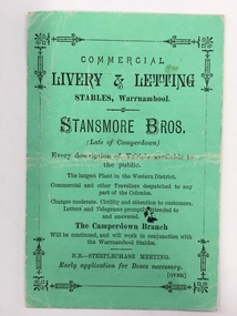 Warrnambool and District Historical Society Inc.
Document, Business Advertising Livery & Letting, 1882
The Warrnambool Amateur Turf Club was first formed in September 1859, but didn't become a properly constituted club until April 1873, when a meeting was held at the Commercial Hotel, now the Whaler's Inn, and a committee was elected.Part of the present racecourse of 100 acres was set aside as a racing and recreation reserve in August 1855. It is one of the finest racecourses in Australia, ringed by the gentle slopes of a huge basin.The first race meeting was held on the course in August 1858. The Warrnambool Racing Club has managed racing at Warrnambool since it was formed on 5 April 1873.Apart from a number of smaller meetings held throughout the year, the feature of racing in the district is the Grand Annual Steeplechase. The first steeplechase over the now famous cross-country course was run on 13th June 1872 then known as the Grand Annual Steeplechase. The paddocks now know as Brierly and Granters were first used on that date. The course, over four miles, was made up of different kinds of jumps including a stone wall, a log fence, a ditch and parapet, a paling fence and numerous post and rails.This card has Warrnambool Racing Club acceptances on one side for the Winter steeplechase meeting for the June meeting in 1882. Stansmore Bros. operated livery stables near the Commercial Hotel in Liebig Street around this time having commenced their business in Camperdown.They later moved to Kepler Street. The Stansmore family had a long association with the racing and agricultural industry in the Camperdown and Heytesbury areas. This little card has links to one of Warrnambool's premier sporting events and a local business which has strong family connections in the district.Small green card with black text on front and back. Edged with small lined border. The back has a racing schedule.Commercial Livery & letting Stables Warrnambool.Stanmore Bros. Warrnambool Racing Club, J.A Archibald Secretary WRCwarrnambool,, commercial livery & letting stables, stansmore brothers stables, warrnambool racing club 1882 -
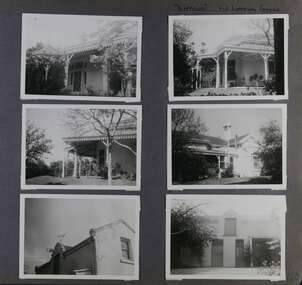 Glen Eira Historical Society
Album - Album page, Lirrewa, 1-3 Lirrewa Grove, Circa 1972
... parapets ...This photograph is part of the Caulfield Historical Album 1972. This album was created in approximately 1972 as part of a project by the Caulfield Historical Society to assist in identifying buildings worthy of preservation. The album is related to a Survey the Caulfield Historical Society developed in collaboration with the National Trust of Australia (Victoria) and Caulfield City Council to identify historic buildings within the City of Caulfield that warranted the protection of a National Trust Classification. Principal photographer thought to be Trevor Hart, member of Caulfield Historical Society. Most photographs were taken between 1966-1972 with a small number of photographs being older and from unknown sources. All photographs are black and white except where stated, with 386 photographs over 198 pages.From Victorian Heritage Database citation for Lirrewa - HO39 Tarqua and Stables, 1-3 Lirrewa Grove Caulfield South https://vhd.heritagecouncil.vic.gov.au/places/120932 (as at 26/10/2020) "Tarqua", now "Lirrewa", is situated at nos. 1-3 Lirrewa Grove, Caulfield South, and was built in 1886 for Montague William Langdon, son of the merchant Joseph Henry Langdon of nearby "Rosecraddock". It is historically and aesthetically significant. It is historically significant (Criterion A) as one of the Langdon family residences, comparing in Glen Eira also with "Rosecraddock" at 10 Craddock Avenue (1857) and "Hengar" at 356 Glen Eira Road (1889-90). It is aesthetically significant (Criterion E) for its capacity to demonstrate the stylistic influences prevailing at the time especially for substantial residences. At "Tarqua", the design acknowledges the prevailing popularity of the Italian Style in the shallow hipped roof form and symmetrical facade as well as the picturesque Gothic Revival style demonstrated especially by the use of pointed arches, fretted barges and the battlemented parapeted section. This latter style was particularly attractive to persons of means on account of its English precedents, the combination of influences being skillfully handled in this instance.Page 120 of Photograph Album with six photographs (all landscape) of views of Lirrewa, mostly including its garden.Handwritten: "Lirrewa" 1-3 Lirrewa Grove [top right] / 120 [bottom right]trevor hart, verandah, lirrewa, tarqua, 1880's, montague william langdon, italian style, shallow hipped roof, symmetrical facade, gothic revival, pointed arches, fretted barges, battlemented parapet, terraces, boom era, single storey, timber roof brackets, frieze, gables, cast iron ridging, lirrewa grove, cast iron work, caulfield, arches, parapets, gardens, houses, victorian style, caulfield south -
 Ballarat Heritage Services
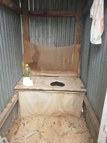
Photograph - Photograph - Colour, Clare Gervasoni, Toilet at St Laurence O'Toole Catholic Church, Sandon, 2017, 08/04/2023
St Laurence O'Toole church and cemetery is located in a rural setting at 801/821 Creswick-Newstead Rd, Sandon. Originally a small wooden school (22’x14’) was erected in Sandon by Father Patrick Smyth (who was involved in the Eureka Stockade movement) in 1859. It was also used for Mass and became known as a chapel. In June 1882 tenders were called for the construction of a brick Church by the Castlemaine architect, T.F. Kibble, and it was built at a cost of 1000 pounds. The church was blessed by Archbishop Goold on 06 May 1883 and dedicated to St Laurence O'Toole. The brick building demonstrates original design qualities of a Victorian Rudimentary Gothic style, including the steeply pitched, parapet gable roof form, together with a central steeply pitched, gabled porch that projects slightly from the main gable end. Other intact qualities include the exposed brick wall construction, lapped galvanised corrugated iron roof cladding, minor gabled porch at the rear, small ventilation dormers nearby the roof ridgeline, series of stone steps that lead to the central porch with its double pointed door opening and vertical boarded doors, simple rose window in the main gable end, pointed windows, brick buttresses with double lower copings, and the light masonry detailing (the banding marking the floor level within, buttress copings, window and door surrounds and quoins, and the drip moulds).(Shire of Mount Alexander: Heritage Study of the former Shire of Newstead, 2000) The visually connected cemetery demonstrates important visual qualities formed by the regular rows of graves and cemetery architecture, and the grassed and treed rural landscape. It is a rare and substantially intact example of a Victorian Catholic Church with a cemetery in its churchyard. Many headstones and cemetery architecture, date from the 19th century and represent some fine examples of masonry craftsmanship. Some refurbisments occurred during the 1940s and in 2002 a major restoration project was undertaken from roof to footings, by a dedicated band of volunteers and trades people. Work was completed mid 2003 and in November 2003 St Laurence’s was re-dedicated with the celebration of Mass and a picnic tea. Colour photograph of a long drop toliet at the Catholic Church, Sandon, Victoria.sandon, sandon cemetery, st laurence o'toole catholic church, sandon -
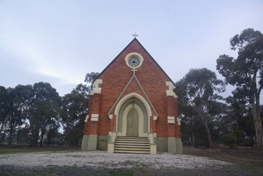 Ballarat Heritage Services
Photograph - Photograph - Colour, Lisa Gervasoni, St Laurence O'Toole Catholic Church, Sandon, 2017, 16/07/2017
St Laurence O'Toole church and cemetery is located in a rural setting at 801/821 Creswick-Newstead Rd, Sandon. Originally a small wooden school (22’x14’) was erected in Sandon by Father Patrick Smyth (who was involved in the Eureka Stockade movement) in 1859. It was also used for Mass and became known as a chapel. In June 1882 tenders were called for the construction of a brick Church by the Castlemaine architect, T.F. Kibble, and it was built at a cost of 1000 pounds. The church was blessed by Archbishop Goold on 06 May 1883 and dedicated to St Laurence O'Toole. The brick building demonstrates original design qualities of a Victorian Rudimentary Gothic style, including the steeply pitched, parapet gable roof form, together with a central steeply pitched, gabled porch that projects slightly from the main gable end. Other intact qualities include the exposed brick wall construction, lapped galvanised corrugated iron roof cladding, minor gabled porch at the rear, small ventilation dormers nearby the roof ridgeline, series of stone steps that lead to the central porch with its double pointed door opening and vertical boarded doors, simple rose window in the main gable end, pointed windows, brick buttresses with double lower copings, and the light masonry detailing (the banding marking the floor level within, buttress copings, window and door surrounds and quoins, and the drip moulds).(Shire of Mount Alexander: Heritage Study of the former Shire of Newstead, 2000) The visually connected cemetery demonstrates important visual qualities formed by the regular rows of graves and cemetery architecture, and the grassed and treed rural landscape. It is a rare and substantially intact example of a Victorian Catholic Church with a cemetery in its churchyard. Many headstones and cemetery architecture, date from the 19th century and represent some fine examples of masonry craftsmanship. Some refurbisments occurred during the 1940s and in 2002 a major restoration project was undertaken from roof to footings, by a dedicated band of volunteers and trades people. Work was completed mid 2003 and in November 2003 St Laurence’s was re-dedicated with the celebration of Mass and a picnic tea. Colour photograph of a brick church at Sandon, Victoria.sandon, sandon cemetery, st laurence o'toole catholic church, sandon