Showing 247 items matching "pathway"
-
 Stawell Historical Society Inc
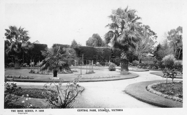
Photograph, Rose Series, Central Park Gardens, c 1910 - 1920
Central Park Gardens Rose Series Postcards P1664. Shows Several Palm trees circular gardens and pathways. c1910-1920.Postcard of The Rose Series P. 1644 Central Park, Stawell. Also included are two enlarged copies of the post card. Post card shows hedge of cypress in the background and various sized Palm trees in round garden beds in the foreground. c1910 - 1920With best wishes for the New year from Bob & Mary written on the back of the post card. Issued by The Rose Stereographs Armadale Victoriastawell, tourism -
 Port Melbourne Historical & Preservation Society
Book, Phil Rickard, Light Railways; Australia's Magazine of Industrial and Narrow Guage Railways, 2019
June 2019 issue of Light Railways; Australia's Magazine of Industrial and Narrow Guage Railways. Article - Pathways around Melbourne page 2, page 8 containing details of Port Melbourne.Number 267 ISSN 07278101 June 2019. $7.95 recommended retail price onlytransport - railways, history, industrial and narrow guage railways -
 Bendigo Historical Society Inc.
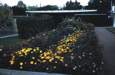
Slide - BENDIGO VIEWS, Mar 1971
Slide. Bendigo Views. A flower bed with marigolds, roses and another red flower along the left edge. There is a pathway along the right edge of the bed. Behind the flower bed are shrubs and a shed.slide, bendigo, bendigo views, bendigo views -
 Stawell Historical Society Inc
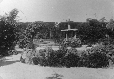
Photograph, Central Park Gardens, c1910
Photograph of Central Park Gardens showing rockery and fountain at center. c1910 Records state the copy was made from original loaned by Barry Griffin.Enlarged Black & White photo of Central Park Gardens showing water fountain surrounded by pathways, lawns and gardens. Duplicate photo also in Griffin Album on page 25, measurements given.stawell -
 Kew Historical Society Inc
Photograph - Men on the bank of the Yarra River, circa 1953
This is one of a series of 17 black and white undated photographic proofs donated to the Kew Historical Society in 2013 by the Queenscliffe Historical Museum. The series includes images of individuals, tea rooms, ferries, motor launches, ocean liners and tugs. The subject of the photograph is a Hicks Bros ferry, which from circa 1921 operated a ferry service from Princess Walk (Melbourne) to Studley Park.Very faded and degraded photograph of a group of men walking down pathways on the bank of a river in Melbourne. The location may be the Hawthorn Tea Rooms. The undated photographic positive was probably taken in the 1950s.melbourne, tourism -
 Eltham District Historical Society Inc
Photograph, Doug Orford, Completion of bridge works across Yarra River at rear of Eltham Lower Park, July 2004
Bitumen shared pathway under construction at the new Eltham-Templestowe footbridge over the Yarra River off Homestead Road, Eltham which was completed in July 2004. The Yarra River Footbridge was opened in August 2004 and links the Diamond Creek Trail between the Shire of Nillumbik and City of Manningham. It is a shared pathway and also links with the Main Yarra Trail. It affords lovely views over the Yarra River.Three colour photographs showing commencement of construction of Eltham-Templestowe footbridge over Yarra River off Homestead Road, Eltham which was completed July 2004. Third photograph of dedictaion plaque at opening 30 Aug 2004bridges, yarra river, eltham south, eltham lower park, lenister farm, homestead road, asphaldt, bitumen, shared pathway, diamond creek trail -
Bendigo Historical Society Inc.
Programme - 125th Anniversary, March 1998
Strathfieldsaye State School (SS 1211) began in the Shire Hall in March 1873. Five acres was gazetted in January 1874 and a three roomed, weatherboard school building opened in January 1875.Stathfieldsaye Primary School 125th Anniversary programme and tour guide. 1873 to 1998. The six pages includes a song called Pathways to the future by Gail Godber; a programme; history of the school and a plan of the school.history, bendigo, strathfieldaye primary school, back to celebrations 125th anniversary, gail godber -
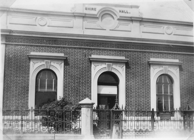 Stawell Historical Society Inc
Photograph, Stawell Shire Hall 1866
Stawell Shire Hall built 1866. In this black & white photograph of the Shire Hall a white panel can be seen over the top section of the doorway to the building. Stawell Shire Hall built in c 1866. This black and white photograph shows just the front of the building with a white panel over the doorway. A small shrub on the left of the pathway behind the decorative fence.c 1937.stawell -
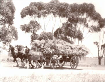 Sunbury Family History and Heritage Society Inc.
Photograph, Clydesdale Horses
The photograph was taken on the property owned by the Beer family, situated on Lancefield Road. When Europeans first settled the area and the property was acquired by Michael Coolaton in the 1850s, it straddled either side of the Emu Creek. After the death of Michael Coolaton in 1896 and until the Beer family purchased it in 1953, the property was leased to a number of tenants who concentrated on a variety of grazing and cereal growing pursuits. The Beer family have raised cattle and a Clydesdale stud. Today there are remains of drystone fences and some stone buildings on the property.The Clydesdale Stud raised on this property is of significance in the former Shire of Bulla.A non-digital black and white photograph with a narrow cream border of a man driving a team of three Clydesdale horses pulling a wagon loaded with hay along a pathway . A row of gum trees is in the background.beer family, lancefield road, clydesdale stud, horses, cattle, emu creek -
Bialik College
Work on paper - Bialik Primary School Upgrade Architect images
Bialik Primary School Upgrade March 2014 Level One as created by Ron Unger Architects. No descriptive labels. Looks like ECC and outside pathways.84 x119cm Colour printed boards of plansNo descriptive lables -
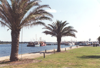 Lakes Entrance Historical Society
Photograph - Cunninghame Arm, L E Tidy Town Committee, Lakes Entrance Victoria, 1994 c
Colour photograph of pathway with newly planted palm trees beside Cunninghame Arm, tourist launch jetty and moored boats in distance Lakes Entrance Victoria. Also a second colour photograph of similar view tourism, jetties, boats and boating -
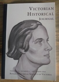 Tatura Irrigation & Wartime Camps Museum
Book, Victorian Historical Journal Volume 87 Number 2 December 2016
Articles on various topics, including Melbourne Labour Market, Storm Centre of Asia, Beechworth Goldfields, Wirrengren-Kulkyne Pathway, Messrs Gellibrand and Hesse. 336 pages.Soft cover book, front cover has title in dark grey on cream background. Picture of a lady looking to the right. Volume, number and date and Royal Historical Society of Victoria at the bottom. Spine is black with white writing. Back is brown with Royal Historical Society logo and address.melbourne labour market, storm centre of asia, beechworth goldfields, wirrengren-kulkyne pathway, mr gellibrand, mr hesse -
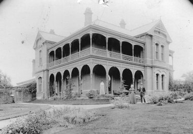 Stawell Historical Society Inc
Photograph, "Oban" House with ladies and gentleman
Lady and gentleman standing on garden pathway in front of home and younger girl standing on verandah. Note on left behind building is the now demolished kitchen/servants area. stawell houses -
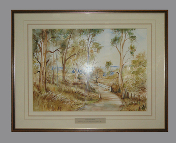 South Gippsland Shire Council
Framed watercolour painted by Bianca Biesuz, "Dryings Road Bridge", 1987
Painted by Bianca BiesuzCream card window mount with pink edging lines. Text panel cut out lower edge. Brown wood frame with gold edging. Painting portrays trees with a pathway through them, white bridge,"Dryings Road Bridge" -
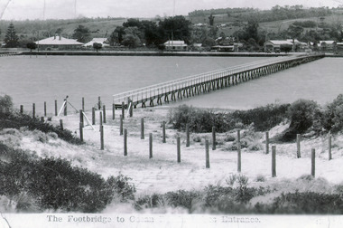 Lakes Entrance Historical Society
Photograph - Footbridge, 1937c
Two other copies 6.5 x 9 imageBlack and white photograph showing waterfront, Esplanade, some buildings and background hill almost completed footbridge across Cunninghame Arm. Posts defining pathway over sand dune to ocean beach. Lakes Entrance VictoriaFootbridge to Ocean Beach, Lakes Entrancewaterways, bridges, township -
 Greensborough Historical Society
Booklet, BNLLEN, BNLLEN Annual Report 2019, 2019_
2019 Annual Report for BNLLEN (Banyule Nillumbik Local Learning & Employment Network). Outlines activities, staff and finances for the year. BNLLEN provides education, training and employment pathways for young people.22 pages, colour illus.bnllen, banyule nillumbik local learning & employment network, youth employment -
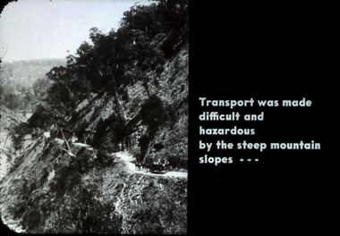 Bendigo Historical Society Inc.
Slide - DIGGERS & MINING. DIGGERS AND MINERS, c1800s
Diggers & Mining. Diggers and miners. Walhalla - Gold Town. Transport was made difficult and hazardous by steep mountain slopes - - - Photo depicts a steep slope with a pathway around the mountain. Markings: 16 995 WAL. Used as a teaching aid.hanimounteducation, tertiary, goldfields -
 Sunbury Family History and Heritage Society Inc.
Photograph, Sunbury Asylum, c1920s
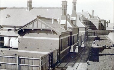
The brick buildings in the photograph are of the former Sunbury Asylum and F3 Ward is in the foreground. Initially the site on Jackson Hill also known as She0ak Hill opened as an Industrial School for orphaned or neglected children and in 1879 it became an asylum where it continued to function as an asylum until the Victorian Government closed it on 20th November 1992.The Sunbury Asylum played an important part in Sunbury and wider community's development over 150 years. throughout its existence there was much interaction between the residents, staff and local community, many of whom were employed at 'The Hill' as it was known locally. A sepia non-digital photograph of a large brick hospital building with three nurses standing outside it on a narrow pathway edging a garden bed. A picket fence is at the rear of the building enclosing a small yard where washing is drying on the line.sunbury asylum, jackson hill, caloola, sheoak hill, ward f3 -
 Lakes Entrance Historical Society
Photograph - Fraser Island, Holding M, 2000c
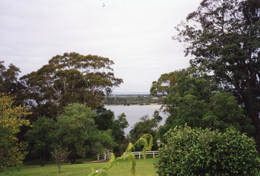
Colour photograph taken from the veranda of Nyerimilang Homestead, Gippsland Lakes. It shows a glimpse of Fraser Island through the trees and ornamental shrubs of the homestead garden. Fence and pathway to viewing platform in centre foreground. Lakes Entrance Victoriaislands, historic site -
 Lakes Entrance Historical Society
Photograph - Cunninghame Arm looking west from Post Office jetty Lakes Entrance Victoria c1994, 1994 c
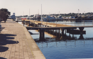
Colour photograph of new jetty beside pathway on Cunninghame Arm looking west from Post Office jetty Lakes Entrance Victoria. Also a second colour photograph of new jetty VTMH04256.1 10 x 15 cmboats and boating, jetties -
 Bendigo Historical Society Inc.
Slide - PETER ELLIS COLLECTION: SLIDE, May 1970 - Jan 1972
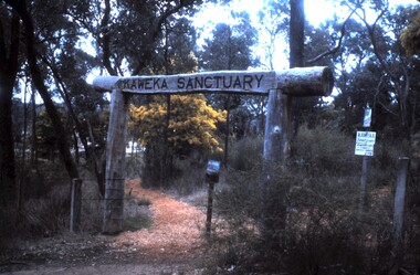
Coloured slide transparency. Image is of the entrance to a sanctuary. A wooden frame is across the entrance with the words Kaweka Sanctuary across the top of the frame. A donation box is underneath the frame and some signage is to the left. A pathway winds to the background and trees and scrub are also there.Kodachrome Transparencyslide, bendigo, bendigo institute of technology -
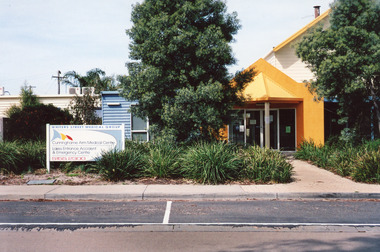 Lakes Entrance Historical Society
Photograph - Medical Centre, Holding M, 2009
Date made September 2009 Site building was originally (games room) part of caravan park Also one other colour photograph closer view of front entrance doorway.Colour photograph of the front entry to Cunninghame Arm Medical Centre at 8 Whiters Street. Appears to be brick or concrete slab facade painted bright yellow. Information sign in native plant garden, brick pathways. Lakes Entrance Victoriamedical facilities, local history -
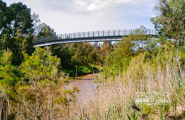 Eltham District Historical Society Inc
Photograph, Footbridge across the Yarra River at Eltham Lower Park
The Yarra River Footbridge was opened in August 2004 and links the Diamond Creek Trail between the Shire of Nillumbik and City of Manningham. It is a shared pathway and also links with the Main Yarra Trail. It affords lovely views over the Yarra River.Colour photographbridge, eltham lower park, eltham south, homestead road, lenister farm, yarra river, footbridge, lookout, diamond creek trail -
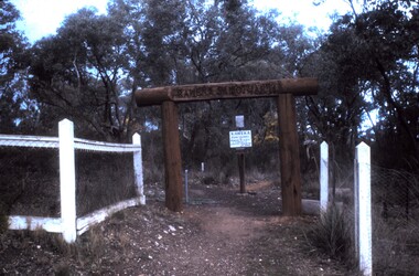 Bendigo Historical Society Inc.
Slide - PETER ELLIS COLLECTION: SLIDE, May 1970 - Jan 1972
Coloured slide transparency. Image is of the entrance to a sanctuary. A wooden frame is across the entrance with the words Kaweka Sanctuary across the top of the frame. A donation box is beyond the frame and a white fence flanks either side.. A pathway winds to the background and trees and scrub are also there.Kodachrome Transparencyslide, bendigo, bendigo institute of technology -
NMIT (Northern Melbourne Institute of TAFE)
Brochures: Career opportunities Northern Metropolitan College of TAFE 1995, Brochures: Career oportunities Northern Metropolitan College of TAFE 1995
A4 size, four sided brochures, one for each course, describing career paths, pathways to further study, and facilities and courses available. Years held 1995 Northern Metropolitan College of TAFE, 1996-1998 Northern Melbourne Institute of TAFE, 2000- NMIThandbooks, northern metropolitan college of tafe, northern melbourne institute of tafe, nmit -
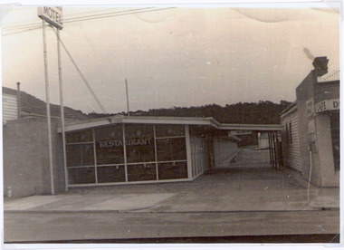 Lakes Entrance Historical Society
Photograph, 1960c
The first 20 units and restaurant were built in 1959 with firsts guests on Dec. 22nd.1959. The units 21-27 plus the front residence and office were built in 1962.Black and white photograph of Tween Lakes Motel, showing restaurant on Esplanade frontage, view through driveway to Marine Parade. Vacancy sign outside office, and pathway beside motel units, corner of Johns Cafe visible opposite restaurant. Lakes Entrance Victoriamotels, restaurant, township -
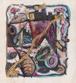 Bendigo Art Gallery
Work on paper, Michael DOWNS, Urban Winter, 1990
l.r; DOWNS 90abstract, city, australian artist, collage, urban, winter, season, pathway, house -
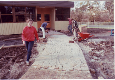 University of Melbourne, Burnley Campus Archives
Photograph - Colour print, James (Jim) Pleasance, Students Building Brick Paths Around Relocatable Buildings, 1985
Note in paper catalogue, "Hard surfacing the pathways around the new relocatable buildings erected on the site of the old Lagoon fill (completed 1977). Students completed most of the work with the central garden area designed by Californian exchange staff member Steve Mullany, 1985." 2 similar colour photographs. Students building brick paths around relocatable buildings in the Quad. On reverse, "13.Sep.1985," and, "Hard surfacing with brick.hard surfacing, bricks, pathways, students, gardens, californian exchange, staff, steve mullany, quad, relocatable buildings, students working outside -
Unions Ballarat
The Paraguayan experiment, Wilding, Michael, 1984
A fictional account of the New Australia Movement, founded by William Lane in 1892. The group sought a socialist utopia and their chosen site was Paraguay. The pathway for the new community was not smooth, but the colony is still in existence. Some people formed colonies elsewhere and others returned to either Britain or Australia.Relevant to the history and development of left-wing politics and socialism in Australia.Paper; book. Front cover: white and yellow text on red background; dominant image is of the settlers amongst flowers with a hut and palm trees in the background.Front cover: author's name and title.btlc, ballarat trades and labour council, ballarat trades hall, lane, william, socialism, paraguay, utopia, new australia movement, nueva australia, politics, collective settlements, new australia co-operative settlement association -
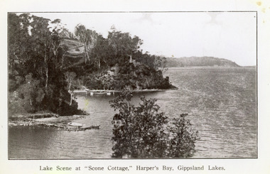 Lakes Entrance Historical Society
Photograph - Scone Cottage, 1920c
Copied from a postcardBlack and white photograph of Harpers Bight, Gippsland Lakes. It shows rustic jetty in foreground with boat moored, jetty below zigzag pathway to Cliff Crest Tea Rooms, a popular tourist venue, run by Mrs Westerson. Distant view of Jemmys Point. Lakes Entrance VictoriaLakes Scene at Scone Cottage, Harpers Bay, Gippsland Lakes tearoom, tourism, waterways