Showing 282 items
matching punting
-
 Melbourne Tram Museum
Photograph - South Yarra Substation, Melbourne & Metropolitan Tramways Board (MMTB), 1966
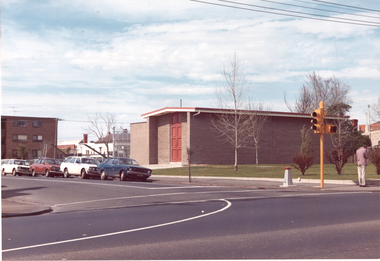
Shows the completed sub-station, built during 1966 at the corner of Greville St and Punt Road South Yarra. See also item 4515 for construction photographs.Shows substation architecture of the 1960sSet of three colour photographs.trams, tramways, substation, electrical equipment, electrical switching, buildings -
 Lakes Entrance Historical Society
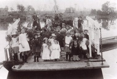
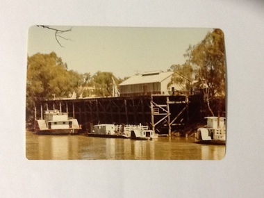
Photograph - Johnsonville Punt, 1921
Black and white photograph of the Johnsonville State School students posed on the Johnsonville Punt moored to the bank of the Tambo River. Many of the children are holding bunches of greenery, perhaps, indicating Arbor Day. Some adults also present. Johnsonville Victoria waterways, schools, transport -
 Melbourne Legacy
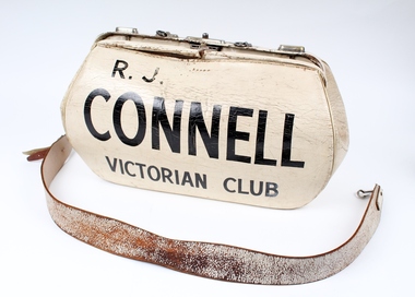
Functional object - Bookmaker's Bag
Bookmaker's bag used as a prop during Legacy golfing and social events. Bags such as this one were used by bookmakers to collect and securely hold punters' bet at racing events.Legatees had many social events together and used items like this.White painted leather bag with metal fastening mechanism. A short painted leather handle is joined to the bag by metal fastening clips. A long painted leather strap is joined to the bag by metal fastening clips.'R.J. Connell / Victorian Club' painted in black and 'U. Pickem / K.E.R.C.' Handwritten in black on other side.legatee event, legatee, golf -
 Lakes Entrance Historical Society
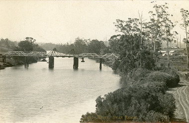
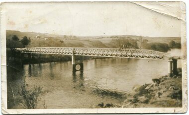
Postcard - Bridges, 1906
Postcard dated 3 December 1913, Bairnsdale, addressed to Mrs Brewer, Metung, Gippsland.Black and white postcard showing wooden lift bridge over Tambo River, Swan Reach, Victoria. Old punt visible at left bank under bank, thick vegetation on right bank, houses in right background above Metung Road.Tambo River, Swan Reachbridges, waterways -
 Eltham District Historical Society Inc
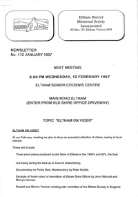
Newsletter, Newsletter, No. 112 January 1997
Contents: • Next meeting, Eltham on Video • 1997 Program • Former Eltham Shire Office Site – Planning Appeal • The “Shillinglaw Trees” • Yarra River Punt, Warrandyte • Annual General Meeting The Shire of Eltham Historical Society was formed in October 1967. The first newsletter of the Society was issued May 1978 and has been published continuously ever since on a bi-monthly basis. With the cessation of the Shire of Eltham in late 1994, the Society's name was revised to Eltham District Historical Society and this name first appeared with issue No. 103, July 1995. The collection of the Society's newsletters provides a valuable resource on the history of the Society's activities, office bearers and committee members, guest speakers and subjects of historical interest pertinent to the former Shire of Eltham and the Eltham District.A4 photocopied newsletter distributed to membersnewsletter, eltham district historical society, shire of eltham historical society -
 Glenelg Shire Council Cultural Collection
Booklet - Booklet - Nelson and Glenelg River, Victoria, Compiled by N.F. Learmonth, Three Ways to Cross a River, Mar-63
Booklet - 'Three Ways to Cross a River', a short history of Nelson, focussing on the crossings of the Glenelg River - ford, punt and bridge. Blue card, cover, black print. Complied to mark the occasion of the opening of the new Glenelg River bridge at Nelson, 14 Mar 1963 -
 Melbourne Tram Museum
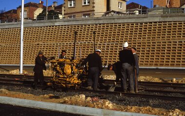
Slide, Keith Kings, 10/08/1968 12:00:00 AM
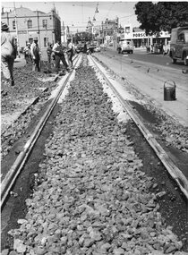
35mm Kodak white cardboard colour slide by Keith Kings of 10/8/1968 Queensway, St Kilda Junction road works, track tamping using a VR hired tamper. Note the cloth wrapped up caps on two of the workers - Italian immigrants most likely. See Keith's slide notes.Keith Kings stamp and number "32-27", with details of exposure. "VR tampers on hire in Freeway section of new track near Punt Road 10/8/68".trams, tramways, st kilda junction, trackwork, road works, queensway, ballast -
 Eltham District Historical Society Inc
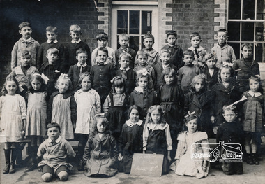
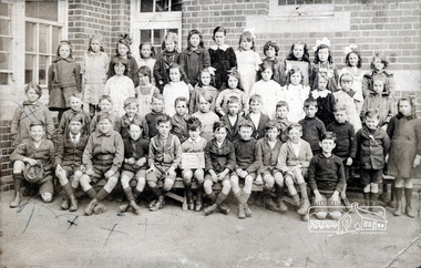
Photograph, Grade IIB, Yarra Park State School No.1406, c.1928, 1928c
Yarra Park State School No.1406 (also known as Yarra Mews) was located at 1055 Punt Road, East Melbourne. It was built 1874 - 1877. Its current use is residential appartments. It is listed in the Victorian Heritage Database. yarra park state school no. 1406, schools, yarra park, yarra mews, class photo, east melbourne, state school no. 1406 -
 Eltham District Historical Society Inc
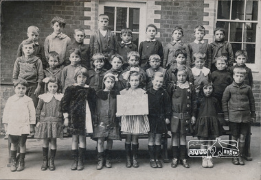
Photograph, Grade IIC, Yarra Park State School No.1406, c.1928, 1928c
Yarra Park State School No.1406 (also known as Yarra Mews) was located at 1055 Punt Road, East Melbourne. It was built 1874 - 1877. Its current use is residential appartments. It is listed in the Victorian Heritage Database. yarra park state school no. 1406, schools, yarra park, yarra mews, class photo, east melbourne, state school no. 1406 -
 Eltham District Historical Society Inc
Photograph, Grade 3B, Yarra Park State School No.1406, c.1928, 1928c
Yarra Park State School No.1406 (also known as Yarra Mews) was located at 1055 Punt Road, East Melbourne. It was built 1874 - 1877. Its current use is residential appartments. It is listed in the Victorian Heritage Database. yarra park state school no. 1406, schools, yarra park, yarra mews, class photo, east melbourne, state school no. 1406 -
 Melbourne Tram Museum
Photograph - Black & White Photograph/s, Melbourne & Metropolitan Tramways Board (MMTB), late 1964
Black and white photographs of Swan St Richmond looking east from near Punt Road - shows the plastic coated rail laid during the late 1950's. See also Reg item 4516 for photos of the methodology. On the photographic box with the photos was a date "11/59"trams, tramways, track laying, track materials, trackwork, swan st, rails -
 Phillip Island and District Historical Society Inc.
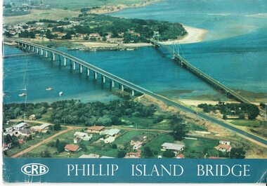
Booklet, Official Opening of the Phillip Island Bridge at San Remo 1969 and notes by the Bridge engineer, Tom Russell, 1969
Prior to 1939 access to the Island was by punt from San Remo or car ferry from Stony Point. A bridge was opened in 1940 but increased traffic and low load capacity was a problem. The decision to build a new bridge was made in the 1960s.HistoricalColoured, bound booklet with a photo of the old and new Phillip Island bridges on the cover and the CRB logo and name on rear. It includes the order of proceedings for the opening and bridge statistics, plans and contractor information. Also photos of construction and a history of travel to the Island before a bridge was built and the first bridge. There is also a 2 page typed document written by the bridge engineer who gives a brief history of access to the Island and problems at the opening with access and a rebel who tried to open it unofficially.Official Opening of the Phillip Island Bridge at San Remo by The Hon. M.V. Porter, MLA. Minister of Public Works. November 21 1969bridges, 2nd phillip island bridge construction, tom russell, phillip island bridge opening 1969 -
 Melbourne Tram Museum
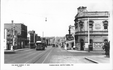
Postcard, Rose Stereograph Co, "Toorak Road South Yarra Vic", c1910
Rose Series postcard No. P 3614 of Toorak Road looking east from Punt Road. Has four cable trams in the view along with horse-drawn carts. Adverts for Dewars. Pears soap, Cadburys, and Carlton Ale. Yields information about Toorak Road c1910Postcard - printed real photograph with Rose Stereograph Co. name on the rear.Has the Ken Magor stamp on the reartrams, tramways, cable trams, toorak road, south yarra -
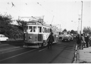 Melbourne Tram Museum
Photograph - Black & White, David Menzies, Tram 245 Normanby Rd Caulfield Races, c1975
Black and white print of W2 class tram 245 picking up passengers in Normanby Road after a race meeting at Caulfield. The tram has the destination of Domain Road. Many punters wait on the kerb while an Inspector supervises.Yields information about the Caulfield Race Traffic.Black and White photograph - printed on plain paper with photographers stamp and notes on rear.Has stamp of David Menzies on rear. and in ink "Caulfield Races '75"tramways, trams, mmtb, caulfield, normanby road, tram 245, domain road, w2 class, race traffic -
 Melbourne's Living Museum of the West
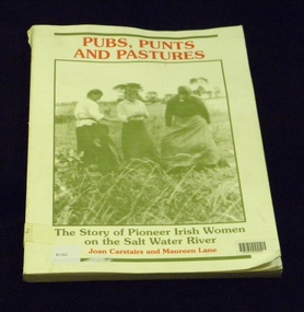
Book, St Albans History Society Inc, Pubs, Punts and Pastures, 1988
Tells the story of early Irish Pioneering Women who settled the Maribyrnong River Valley (formerly Salt Water River) and founded the first hotels, punts (river crossing barges) and farms in the region; and focuses on six particular women and their stories.Book now out of print. Funds from the sales of this book were used to build the monument "The Pioneer Womens Shelter" in Pipemakers Park.Book, soft card cover, 178 pagesISBN 0958808406 Book dedication "This book is dedicated to all women who made the voyage under sail"book, womens history, irish women, pioneers, maribyrnong river, salt water river -
 Melbourne Athenaeum Archives
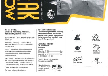
Theatre Flyer, Freak Show (play)by Back to Back Theatre and Circus OZ performed at Athenaeum Theatre Two, Melbourne commencing November 1995
The Dates we sourced on the flyer were November 15 - 25 with night and matinee shows avaible. This Performnce was in association with AAustralian Drug Foundation, BE YOUR bEST. ,VICHEALTH, Playing Australia ,Arts Victoria ,Australiian Council of the Arts and Punt Hill Spirital Apartments .colored yellow and black flyer in the profile of someone wearing a paper bag on his/her head.back to back theatre, circus oz, freak show, athenaeum theatre two -
 Returned Nurses RSL Sub-branch
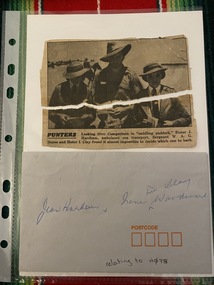
Ephemera - Envelope & two pieces torn newspaper clipping, Punters
Envelope & newspaper clipping with photograph with caption 'PUNTERS Looking Over Competitors in "saddling paddock," Sister J. Harham, ambulance sea transport, Sergeant W. A. G. Heyes and Sister I. Clay found it almost impossible to decide which one to back.'Small envelope and torn newspaper clipping'Jean Hardham & Irene ^ nee Clay Woodward' 'relating to H078' [on envelope]sister j hardham, sergeant w a g heyes, sister i clay -
 Kew Historical Society Inc
Work on paper - Sepia Wash & Ink, G B Richardson, Creek and Old Watering Stage, on the Yarra, East Collingwood, 1854, 1854
Blind Creek was located between the Abbotsford Convent and what is now the Collins Bridge in Studley Park. In an 1858 map of East Collingwood by Clement Hodgkinson, in the State Library of Victoria, one can see how the creek was originally a significant landmark in Collingwood; remaining vacant land until a barrel drain enclosed it. The area was later filled in, surveyed and developed. The position where Blind Creek entered the Yarra was in the immediate vicinity of Hodgson’s Punt, which had linked Kew to the other side of the Yarra from 1839. The Punt was purchased by the Colonial Government in 1852 and was in use until the opening of the Studley Park Road (Johnston Street) Bridge in 1858 made its continued use redundantThe point of view selected by the artist for the watercolour is from the banks of Blind Creek in East Collingwood, looking across the Yarra to the Kew side of the river.Inscribed verso 'Creek and Old Watering stage, on the Yarra East Collingwood 1854 / Trees, stage, &c have long since disappeared / [Artist Signature] / FT 110 / Creek itself now being filled in 1903.gb richardson, blind creek - abbotsford, yarra river - abbotsford (vic) - kew (vic), colonial artists, australian art - 19th century, george bouchier richardson -
Tatura Irrigation & Wartime Camps Museum
Photograph - copy, William Day's Flour Mill, 1987 copy
Copy of photograph of flour mill l built by William Day in 1858. The earliest flour mill in the Goulburn Valley. Overlooking the Goulburn River, where a punt carried people, livestock and mill products to and from the mill. Classified by National Trust. Photographs courtesy of R. Day.Black and white copy of photograph of exterior of William Day's Flour Mill, near Murchison. Built 1858.on back: Description taped to back -
 Port of Echuca
Colour Photograph, Approx.1979
P. S. PEVENSEY: Dimensions: 111ft 5 ins X 23 ft X 6ft 8 ins. Tonnage:130 tons Built: 1910 at Moama, N. S. W. References : Book: Murray river Paddle Steamers by D. Wardle Permewan , Wright & Co. : pp. 72, 129, 157 The P. S. PEVENSEY holds historical and social significance for the Port of Echuca, being the cornerstone of their paddlesteamer fleet. The PEVENSEY was renamed for the TV series All the Rivers Run, to P. S. Philadelphia , playing a staring role in the program, which has resulted in the PEVENSEY becoming a tourist attraction and has increased tourism to the Port of Echuca. The PEVENSEY was originally designed for use on the Murrumbidgee river, named after Pevensey station on that river. It was then owned by Permewan Wright & co operating out of Echuca for many years. She returned to Echuca in 1975 to begin another life as part of the Port of Echuca tourism operation.Colour photograph of the wharf and the back of the P. S. Pevensey, moored at the Port of Echuca wharf , c.1979. In front of her is a punt , a small paddle boat and to the right of the photograph part of the back of the P. S. Etona. The Cargo shed and the cranes can be seen on the wharf. Photograph taken looking south along the river.. Printed on reverse: This paper manufactured by Kodakriverboats, p.s.pevensey, echuca, port of, paddle steamers, echuca wharf -
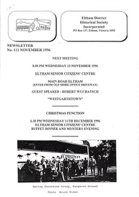 Eltham District Historical Society Inc
Newsletter, Newsletter, No. 111 November 1996
Contents: • Next meeting, guest speaker; Robert Wuchatsch: Westgarthtown • November Meeting • Christmas Function • Society Headquarters • President’s Report • Spring Excursion • Eltham Heritage Trail • Nillumbik Heritage Study • More News • A Punt Across the Yarra at Eltham? • Former Eltham Shire Office Site The Shire of Eltham Historical Society was formed in October 1967. The first newsletter of the Society was issued May 1978 and has been published continuously ever since on a bi-monthly basis. With the cessation of the Shire of Eltham in late 1994, the Society's name was revised to Eltham District Historical Society and this name first appeared with issue No. 103, July 1995. The collection of the Society's newsletters provides a valuable resource on the history of the Society's activities, office bearers and committee members, guest speakers and subjects of historical interest pertinent to the former Shire of Eltham and the Eltham District.A4 photocopied newsletter distributed to membersnewsletter, eltham district historical society, shire of eltham historical society -
 Melbourne Tram Museum
Photograph - Set of 12 Black & White Photograph/s, Melbourne & Metropolitan Tramways Board (MMTB), 1966
Series of 12 black and white photographs of the construction of a new substation, during 1966 at the corner of Greville St and Punt Road, South Yarra. Shows the vacant block, construction of the foundations, walls and a part of the roof. In the box was a slip of paper marked - "To Architect 6.6.66" See item 7269 for three colour photographs of the completed building.On the rear of some of the photos are dates eg 30/5 on .1 trams, tramways, substation, electrical equipment, electrical switching, buildings -
 Bendigo Historical Society Inc.
Photograph - DAWN SMITH COLLECTION: PHOTOS OF BENDIGO, c1929
Dawn Smith Collection. Another Black & White Photograph of Baths at The Upper Reserve Bendigo c1929, which changed its name to The Queen Elizabeth Oval (QEO) in the 1950s to commemorate the coronation of Queen Elizabeth II. A small punt glides ably along observed by a solitary onlooker dressed in dark suit and hat carrying a towel.Souvenir Photograph Set Bendigo ? Rose Collectionbendigo, tourism, the upper reserve bendigo (qeo) -
 Orbost & District Historical Society
black and white photograph, first half 20th century
This is the Dalgety bridge across the Snowy River. It is a steel construction.The first bridge over the river was constructed in 1888. There was a punt across the river before the bridge was built . Dalgety is a small service centre, located on the Snowy River approximately 235 km from Orbost. It was an early consideration for the site of Australia,s capital city. The Dalgety Bridge over the Snowy River has been an important item of infrastructure in the history of New South Wales for over 110 years. It was designed by noted bridge engineer J. A. McDonald,and was a technically sophisticated bridge structure for its time. This is a pictorial record of a significant structure on the Snowy River.A small black / white photograph of a large bridge over a river.bridge-dalgety-snowy-river -
 Orbost & District Historical Society
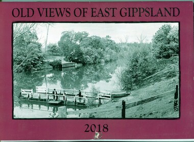
calendar, E-Gee Printers, Old Views of East Gippsland 2018, 2017
This is one a series of calendars compiled annually by East Gippsland Historical Society.This is a useful pictorial reference tool.A 2018stapled calendar, titled "Old Views of East Gippsland". On the purple coloured front is a black/white photograph of a punt on the Tambo River. It has a manual winding winch, three men on a small wharf, one man is fishing. It contains early photographs of East Gippsland, one for each month. There is a hole for hanging. The title is at the top and the year at the bottom in black print. calendar-old-views-of-east-gippsland photographs-historic-east-gippsland -
Federation University Historical Collection
Book, Wrapped in a Possum Skin Cloak
Soft covered book with the image of sewn possum skin pelts on the cover. The book outlines the Toolyn Koortakay collection (National Museum of Australia) comprising of artwork, possum skin dance ornaments, tools, and two cloaks: a reproduction of the Maiden's Punt Yorta Yorta possum skin cloak collected in 1853 and a reproduction of the Lake Condah Gunditjmara possum skin cloak. aboriginal, aborigine, possum skin cloak, possum skin rug, debra couzens, vicki couzens, lee darroch, trehna hamm, amanda reynolds -
 Wodonga & District Historical Society Inc
Album - Ringer's River by Des Martin - Plate 23 - Plans for a ring-in at Nuggety track
Keiran, Artie Klinberg, and an old horse trainer named Tim Byrne combine to make friends with Grapeshot. Nightly they row across the river, feed him on oats, and train him. Their intention is to ring Grapeshot in for Smokey at the Nuggety Flat meeting where Klinberg will punt him well. Des Martin as Byrne. Lt. Col. Tony Hammett as Klinberg.The album and images are significant because they document literature written by a prominent member of the Wodonga community. The presentation of this precis was supported by several significant district families and individuals.Ringer's River Album Coloured photo Plate 23des martin, many a mile, ringer's river, northeast victoria stories -
 Port of Echuca
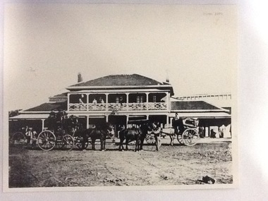
Photograph, Approx. 1970's
The Bridge Hotel was built by Henry Hopwood to house visitors to the town crossing the Murray River on his punt , which was situated just below the Bridge Hotel on the Murray River. The accommodation was spacious and grand! In the right back corner of the photograph, the 'lantern' roof of the St George's Hall can be seen. The street is level with the front entrance to the Hotel, which is very different to what it is today.The photograph shows hotel activities and accommodation in the late 19th Century. The Bridge Hotel was a very busy place as can be seen with women on the balcony, a stage coach full of people, laden carts and buggies.The Bridge Hotel Echuca - photo taken looking south towards front of building. Four people can be seen on the balcony and several gathered under the verandah. In the foreground are several horse-drawn carriages. The road in front of the hotel is unmade and very wide, with the roof of St.George's Hall seen over the right (western) wing of the hotel. Verso: Bridge Hotel, 1860s? St. George's Hall in background.bridge hotel, henry hopwood, lantern roof, st.george's hall, 1870s -
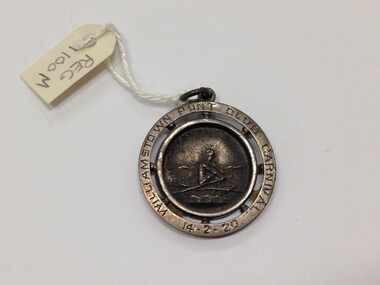 Geelong Naval and Maritime Museum
Medallion, Cadet Cutter Race Medallion, c.1920
UnknownA circular silver metal medallion showing a man rowing in relief. An eyelet at the top is present for hanging the object. "Williamstown Punt Club Carnival 14/2/1920" has been engraved/stamped around the edge. Engraving on the back reads "Cadet Cutter Race won by Geelong No.2 Crew/ J. Kroger" "__SILVER" stamped on back of medallion.williamstown punt club, j. kroger, cadet cutter race -
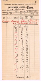 Melbourne Tram Museum
Document - Report, Melbourne & Metropolitan Tramways Board (MMTB), Passenger check - preprinted form 3/201, 15/08/1943 12:00:00 AM
Passenger check - preprinted form 3/201, dated June 1941, for the MMTB as a passenger check or passenger numbers. Completed for the Collingwood to Point Ormond Bus route, at Brunton Ave and Punt Rd of the Sunday 15/8/1943, football game Combined Services vs Essential Services at Richmond Ground - gives passenger numbers from 1.18pm to 3.08pm, completed by Inspector Ellis.On top edge in heavy black pencil "Easter Season 1941"trams, tramways, mmtb, public transport, buses, services, point ormond, collingwood, richmond, football