Showing 104 items
matching regional maps
-
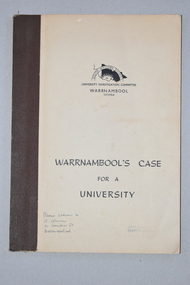 Warrnambool and District Historical Society Inc.
Booklet, Warrnambool's Case for a university, 1961
The information in this booklet was prepared by a University Investigation Committee formed in Warrnambool in 1961 to present the case for the establishment of a university in the Warrnambool area. The chairman of this committee was the Mayor of Warrnambool, Cr P. O’Sullivan and the secretary was W. L. George of Warrnambool. This submission was unsuccessful at the time but campaigning for a university continued. In 1961 Warrnambool Technical School in Timor Street was offering both secondary and tertiary courses in the technical and trades areas and in 1969 the tertiary section of this Technical School became the Warrnambool Institute of Advanced Education. The tertiary section was relocated in 1984 to Sherwood Park, a 94 hectare site on the Princes Highway five kilometres from Warrnambool’s C.B.D. In 1990 Deakin University established a regional campus at Sherwood Park after a merger with the Warrnambool Institute of Advanced Education. This booklet has some historical significance as it contains the information collated on the campaign in Warrnambool and the Western District for a university to be established in the Warrnambool area.This is a soft cover booklet of 48 pages. It has a beige-coloured cover with black printing. The booklet has been bound with brown tape. It has printed information, black and white photographs, a fold-out map, graphs and tables.deakin university, history of warrnambool -
 Bacchus Marsh & District Historical Society
Map, Tracing of plan shewing portion through Bacchus Marsh District of proposed new Main Road between Gisborne and Blackwood
Road construction and planning was a primary function of the early local government authorities in rural and regional Victoria. This plan is indicative of the sort of documentation which generated considerable public interest and comment in rural communities. The date of this plan is not clear. Newspaper articles in the Bacchus Marsh Express around 1869 contain numerous references to the proposed new road between Gisborne and Blackwood which suggests this plan may date from the late 1860s or early 1870s.A single page paper map showing the proposed route of a main road to be constructed between Gisborne and Blackwood. The map is pasted into a bound volume containing 76 maps or plans in total. High resolution digital image stored on BMDHS computer network. roads, road plans, bacchus marsh victoria maps, gisborne to blackwood main road -
 Federation University Historical Collection
Booklet, University of Ballarat, Research@YourUB, 2007 -2010
Research@YourUB is a newsletter highlighting research at the University of Ballarat.1) Spring 2009 .2) Spring 2007 - Rob Wallis, green packaging, mould, food safety, Zhaohao Sun, Widcorp, Jesica Block, Arts Academy anniversary, Dorothy Wickham, Dora Pearce, Loris Button, SmartGreen, Marilyn Davidson, Overcoming bullying in schools, overweight patients. .3) Autumn 2009 - Australian Security Laboratory to fight cybercrime, brewing better beer, John Yearwood, Centre do Informatics and Applied Optimizaton, John Smyth, Angela Murphy? Willows by the water. Patrice Braun, Laura Kostanski, preventing injuries, why should we research art. .4) October 2009 - Future Research Directions .5) January 2009 - Research themes, Wayne Robinson, John yearwood, Andrew Stranieri, Peter Gell, Julian Lowe, John Smyth, John McDonald, Caroline Finch, Dennis Else, Informatics and Applied Optimization, Regional Futures, Disadvantage and Inequality in Education and Health, Injury Prevention and Safety Promotion. .6) Spring 2010 - Frank Stagnitti, Brad Mitchell, Diane Clingin, Robyn Brandenburg, Amanda McGraw-Pleban, Charlynn Miller, Fadi Charchar, Robert Hodder, Amber Stabek, ACSL maps, Murray Darling Basin, Peter Gell, John Smyth, Kate Brass, gaming machines, John McDonald, Helen Aucote, Andrew Cooper, Deborah greeenslade, Dara twomey, Andrew Warnock, synthetic grass, .7) Autumn 2006 - Wayne Robinson, toenail research, Dora Pearce, biodiversity in modified lansdscapes, Centre for Informatics and Applied Optomization (CIAO), John Yearwood, Lawrie Angus, Barry Golding, Georgina Tsolidis, John Smyth, Maxine Cooper, Mary Hollick, Emil Milos, Jeff Woodger, Michelle Ziccolo, Rosemary Green, Raelene Gregory, Julian Lowe, Jessie Harman, Debora Campbell, John McDonald, Denise Corboy, Catherine Knox, Henry Lawson, Meg Tasker, Warren Young, Amanda Telford.university of ballarat, wallis, wickham, wayne robinson, toenail research, dora pearce, biodiversity in modified landscapes, centre for informatics and applied optimization, john yearwood, lawrie angus, barry golding, georgina tsolidis -
 Lakes Entrance Historical Society
Book, Regional Coordination Group and Strategy Steering Committee, The East Gippsland Planning and Development Strategy, 1997
An outline of planning and proposed development by the East Gippsland, Victoria, Shire Council from 1997 to the year 2010. Maps included.township, land settlement, tourism -
University of Melbourne, Burnley Campus Archives
Book - Report, E.B. Littlejohn, Victoria 1944 State Regional Boundaries Committee Report on Regional Boundaries, 1944
See paper catalogue for complete contents. Item formerly property of E.B. LittlejohnReport includes maps of Regions for Planning and Development, geographical, weather, power, water resources, crops, livestock, etc.e.b. littlejohn, planning, development, regions -
 Warrnambool and District Historical Society Inc.
Booklet - Booklet Collection: City of Warrnambool Tourist Guides, Collett, Bain and Gaspar, Warrnambool
This is a collection of sixteen tourist guides dating from the mid 1970's to 2013. These contain listings of businesses, accommodation, eateries and events in Warrnambool and district. They also include maps of Warrnambool and surrounds, advertising and photographs of various attractions. While mainly covering Warrnambool a small number of the guides cover the South West Region. These directories have mainly been published by the Warrnambool City Council and are a selection of the types of information provided to visitors at the Tourist information centre during this time period.These tourist guides give snapshots of the City of Warrnambool for the years covered and will be useful for research.[.1] An 8 page paper booklet with black printing and a black & white photo of the pond at the Botanical Gardens on the front cover. [.2] two photocopied A4 black and white pages from the book "On the Trail" K Winser 1956 (Main Roads of Australia) [.3] A trifold colour brochure with a stylised map of the coast on the yellow and blue front cover. The inside has stylised colour drawings on Warrnambool attractions. The rear cover has coloured photographs of bush, Liebig Street and Fletcher Jones gardens [.4] A trifold black and white brochure with a black line drawing of a whale on the front cover. [.5] A trifold white card with mauve printing. The front cover has a line drawing of the former Timor Street post office and a map of businesses and landmarks in Timor Street. The reverse side contains a brief history of Warrnambool. [.6] A 98 page stapled booklet with a foreword by Vanda Savill. There are 4 pages of coloured photographs. The remainder are black and white photographs. The front cover is purple with white writing in the lower third. There is an outline of the coast and five colour photographs of district attractions. The inside middle page has a map of the Western wonderland region. The content covers towns in this area. Content relating to Warrnambool is in the last six pages. [.7] Twelve loose photocopied black and white pages. The front cover has the Warrnambool Premier Town 1988-1991 logo and a photo of a Southern Right Whale and calf. The bottom right hand corner has a Standard Warrnambool logo. [.8] 44 page booklet printed with blue ink. The staples have been removed. The glossy front cover has blue printing with a coloured photo of Flagstaff Hill Maritime Village pond. The centre pages has a fold out map of the City of Warrnambool. The rear cover has photos of The Twelve Apostles and Hopkins Falls. [.9] 4 loose photocopied pages with Warrnambool Library and Corangamite Regional Library Service Warrnambool City Library black ink stamps. The front page line drawing illustrations of Warrnambool attractions [.10] A single sheet of glossy white paper folded in half to make four pages. The front page has a Warrnambool premier town logo 1979-1982 and blue printing and a visitor survey. [.11] A conference pack of light card folded to make a pocket containing three brochures, a shipwreck coast tourist directory and a Australian Heritage Parks Association conference program dated 24 to 27 May 1992. The front cover of the pack has green writing over a stylised upward arrow. There is a City of Warrnambool logo in the top right hand corner and two film strips diagonally across the cover containing photographs of Warrnambool. The rear cover has a coloured Warrnambool Premier Town logo. [.12] A 63 page stapled booklet with coloured photographs of Warrnambool. The front cover has black writing on white background. There is a coloured photograph of Flagstaff Hill in the middle of the cover and a Warrnambool City and Visit Victoria logos on the lower edge. The middle pages has a coloured of the city of Warrnambool with an inset map of Allansford. [.13] A single large sheet of white paper folded in ten to make a brochure. The front cover has black printing. The rear cover has a purple ink stamp for the City of Warrnambool Tourist Information Centre. When folded out the reverse side has a green, grey and white map of the South West Region of Victoria. [.14] A 48 page colour booklet on glossy paper. The front cover has white writing on a blue background and includes photographs of the Twelve Apostles, the Promenade walk, Flagstaff Hill and a southern right whale's tail. The rear cover has photographs of The Twelve apostles, a passenger train from Melbourne passing the Lake Pertobe playground, and a rural scene. There is white writing and a white Warrnambool City logo on a blue background. The centre pages have a stylised green and blue map of the city of Warrnambool. [.15] A 48 page colour booklet on glossy paper. The front cover has white writing over colour photographs of two people at a lookout, Flagstaff Hill, three southern right whales and a child at the Lake Pertobe playground. The lower edge has blue upper case writing on a white background. The rear cover has a colour photograph of the Twelve Apostles. The lower white border on the rear covers has a a blue and green City of Warrnambool logo and blue writing. The centre pages have a stylised green and blue map of the city of Warrnambool. [.16] A 64 page colour booklet on glossy paper. The front cover has black writing on a black background and there is a photograph of a southern right whale's tail. The lower edge has the Warrnambool City and Visit Victoria Logos. The centre pages have maps of Warrnambool and surrounds. [.1] This week in Warrnambool Vol 2 No. 5 Thurs 1st Feb. For the time of your life [.2] Warrnambool Way [.3] Warrnambool The Holiday Host on the South West Coast with compliments City of Warrnambool and Warrnambool Chamber of Commerce [.4] MMI Insurance presents Whales Giants of the Deep Whale Watcher's Logbook Warrnambool [.5] Warrnambool History began in Timor Street [.6] Western Wonderland Tourist Association [.7] A Premier Arrow Tour of Warrnambool Victoria's Premier Town Australia's Southern Right Whale Nursery [.8] Warrnambool The Heart of Victoria's Great Southwest Visitor's Handbook [.9] What to see in Warrnambool Victoria's Premier City 1979-1982 [.10] Win a Free Holiday & $200 Cash in Victoria's Premier Town [.11] Advancing Warrnambool together! [.12] Great Ocean Road Warrnambool Official Visitor Guide [.13] Tourist guide to the South West Region Victoria All it needs is you [.14] Warrnambool visitor guide 2005 the great ocean road experience attractions accommodation entertainment dining [.15] Warrnambool Visitor Guide 2006 the great ocean road experience Attractions Accommodation Entertainment Dining [.16] Official Visitors' Guide Warrnambool Victoria Australia Discover the Great Ocean Road warrnambool, warrnambool tourist guides -
 Federation University Historical Collection
Map, Ballaarat Gold Field, 1861, 1861
A party of surveyors camped by Yuille's Swamp (later Lake Wendouree) and surveyed the countryside for a map to be produced by the Geological Survey of Victoria. In November 2004 the Central Highlands Regional Library presented a special edition of 200 copies of the 1861 map reproduced from a copy in their collection. Original 1861 map of Ballarat showing streets and leads. Blue dots indicate gold leads, and red lines indicate auriferous quartz reef and outcrops of quartz veins."Compiled & Drawn from the Survey of Mining Surveyors Davidson, Fitzpatrick and Cowan & the Plans in the Surveyor General's Office by J. Brahe, 21st October 1861. R. Brough Smyth, Secretary for Mines. The Honourable J.B. Humffray, M.L.A. Commr of Mines.”ballarat, map, ballarat east, lake wendouree, survey, mines, robert davidson, ballarat gold field 1861, yuille's swamp, wendouree swamp, little bendigo diggings, gold leads, old post office hill, specimen hill, bakery hill, black hill, dead horse creek, brown hill, pennyweight hill, clayton hill, soldiers hill, golden point, gum tree flat, white flat, poverty hill, chinese village, robert brough smyth, ballarat map 1861, ballaarat vineyard, dead horse gully, deadhorse creek, invermay, black hill flat, gaelic church, police reserve, magpie range, dalton's flat, caadian lead, rifle butts, powder magazine, bathing house, government camp, gold office, chinese, llanberrris, victoria theatre, charlie napier hotel, united states hotel, grape's hoel, clayton's hill, cattleyard hill, free trade hotel, esmond lead, bakery hill, black hill lead, juvenile reformatory, ballarat orphanage, lady barkly lead, triffet's slaughter yard, little bendigo, melbourne road, t. cowan, thomas cowan -
 Bendigo Historical Society Inc.
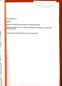
Book - STRAUCH COLLECTION: A SOCIAL HISTORY OF DIAMOND HILL AND VICINITY
BHS CollectionGraduate diploma of regional studies history thesis submitted to La trobe University College of Northern Victoria 1992 'A Social History of Diamond Hill and vicinity 1851-1900' contains maps, graphs & black and white photographs.Diane Dougallbendigo, history, diamond hill, bendigo-history-mining -
 Mont De Lancey
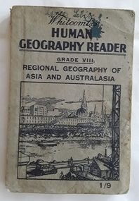
Book, Whitcombe & Tombs Limited, Whitcombe's Human Geography Reader Grade VIII - Regional Geography of Asia and Australasia, c 1930's
A Human Geography Reader for Grade VIII. Regional Geography of Asia and Australasia specially written to meet the requirements of the Social Studies (Geography) Course of Study in Victorian Schools. It stresses the necessity to win the interest of pupils and the important part geography has played in the history of the world. There is an emphasis on the regional study of Australasia.A small grey paperback reader or textbook with black lettering on the front cover at the top for the title Whitcombe's Human Geography Reader Grade VIII. A cost of 1/9 is printed in the lower right hand corner. A black and white illustration inside a square shape is of a city near a river and wharf activities. Throughout are black and white charts, maps, diagrams, photographs and illustrations. Inside the front and back covers are further Whitcombe and Tombs titles as well as on the outside of the back cover. Blue ink writing on the front of Lance Sebire. Some ink stains inside with a damaged worn cover and stains. 208p.non-fictionA Human Geography Reader for Grade VIII. Regional Geography of Asia and Australasia specially written to meet the requirements of the Social Studies (Geography) Course of Study in Victorian Schools. It stresses the necessity to win the interest of pupils and the important part geography has played in the history of the world. There is an emphasis on the regional study of Australasia.children's books, handbooks, textbooks, geography -
 Melbourne Tram Museum
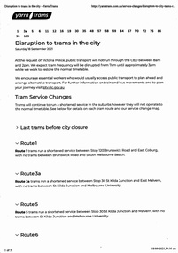
Ephemera - Timetable, Public Transport Victoria (PTV), "Disruption to trams in the City", 17/09/2021 12:00:00 AM
Set of four documents associated with a planned major Demonstration over COVID-19 lockdowns planned to be held in the city on Saturday 18/9/2021. The actual event took place outside Richmond Town Hall and then in Barkers Road Hawthorn. News stories of the night did show some trams were caught up in the event. .1 - set of 5 pages printed from the Yarra Trams website showing changes route by route and a map. .2 - set of 6 sheets from the PTV website including Metro Trains and regional services. Note many VLine crews were impacted by a COVID outbreak and were isolating. .3 - Yarra Trams Employee Notice Y21653 - digital image copy only .4 - Map of the event - digital image.trams, tramways, covid-19, timetables, tram services, events -
 Federation University Historical Collection
Map, Ballaarat Gold Field, 1861, 21/10/1861
A party of surveyors camped by Yuille's Swamp (later Lake Wendouree) and surveyed the countryside for a map to be produced by the Geological Survey of Victoria. In November 2004 the Central Highlands Regional Library presented a special edition of 200 copies of the 1861 map reproduced from a copy in their collection. Original geological map of Ballarat showing property, waterways, mines, churches, schools, water races, and garden reserves. It was compiled and drawn from the surveys of Mining Surveyors Davidson, Fitzpatrick and Cowan.Compiled & Drawn from the Survey of Mining Surveyors Davidson, Fitzpatrick and Cowan & the Plans in the Surveyor General's Office by J. Brahe, 21st October 1861. R. Brough Smyth, Secretary for Mines. The Honourable J.B. Humffray, M.L.A. Commr of Mines.ballarat, map, davidson, robert brough-smyth, fitzpatrick, cowan, yuille's swamp, public garden reserve, manure depot, black hill, ballarat east, old post office hill, pennyweight hill, claytons hill, golden point, mining, railway, cricket ground, swamp creek, cemetery, sludge reserve, bakery hill, gaelic church, juvenile reformatory, orphanage, specimen hill, eureka lead, cattle yard hill, dalton's flat, chinese village, poverty hill, railway reserve, little bendigo diggings, pound reserve, allied armies, flour mill, agricultural reserve, marsh, survey reserve, survey corps, white flat, yarrowee, yarrowee creek, brache, j. brache, survey, ballaarat gold field 1861 -
Lakes Entrance Historical Society
Book, Commonwealth Forests Taskforce, Regional 1999 Assessment Report for Forest Agreement, 1999
... to support the forest agreement process containing many maps ...Comprehensive report prepared by officials to support the forest agreement process containing many maps in Gippsland Victoriaforest, heritage -
Clunes Museum
Book - BUSINESS DIRECTORY, UNIVERSAL BUSINESS DIRECTORIES (AUST) PTY LTD, UBD BUSINESS AND STREET DIRECTORY 1971, 1971
BUSINESS AND STREET DIRECTORY OF BALLARAT AND SURROUNDING DISTRICTSRED COVERED DIRECTORY WITH MAP OF VICTORIA ON THE COVER. 36 PAGES OF BUSINESS ADVERTISING AND ADDRESSES WITH SOME MAPS OF BALLARAT AND SURROUNDING DISTRICTS. PAGE 46 SHOWS CLUNES BUSINESSES.non-fictionBUSINESS AND STREET DIRECTORY OF BALLARAT AND SURROUNDING DISTRICTSregional businesses, clunes businesses -
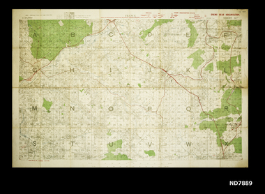 Whitehorse Historical Society Inc.
Map - WW1 map of France, WW1 map of France - regional. Field Survey Map of Enemy Rear Organisation, 08/10/1918
... WW1 map of France - regional. Field Survey Map of Enemy... of Enemy Rear Organisation WW1 map of France - regional. Field ...Enemy Rear Organisation map Scale 1 : 40,000Field Survey Map of Enemy Rear Organisationnon-fictionEnemy Rear Organisation map Scale 1 : 40,000maps, world war 1914 - 1918