Showing 307 items
matching stone wall
-
 Bendigo Historical Society Inc.
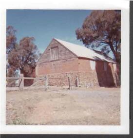
Photograph - FARM BUILDING
... has stone base, brick walls and timber and iron roof... BUILDINGS farming stone building architecture heritage Photo ...Photo: coloured photo off farm (?) building. Building has stone base, brick walls and timber and iron roof. In front of photo, post and rail fence with iron gate.buildings, farming, stone building, architecture, heritage -
 Federation University Historical Collection
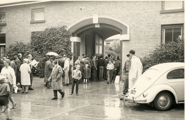
Photograph - Photograph - Black and White, W.G.(Geoff) Little, Open Day at the Former Ballarat Gaol, 1964, 07/03/1964
... tower; .5) Looking through bars to stone wall; .6) Walking... through bars to stone wall; .6) Walking down the narrow steps from ...On 7 March 1964 the Former Ballarat Gaol was opened to the public resulting in a large turnout. These photos were taken during the visit and show various sections, inside and outside, of the gaol. .1) Shows the ground queued up; .2) Front entrance, people starting to move inside; .3) Looking through the bars; .4) view of the curved wall with sentry's walk and guard's tower; .5) Looking through bars to stone wall; .6) Walking down the narrow steps from the top of the wall. This would have been used by guards; .7) Area showing the individual cell doors; .8) People in cell area. An upper level is shown. The gallows is on this level; .9) Stairs leading up to the gallows; .10) Turret above the cell block; .11) Cell area; .12) Cobbled area.Twelve black and white images taken at the open day of the Former Ballarat Gaol, held by the Ballarat Branch of the National Trust on 7 March 1964.ballarat gaol, ballarat school of mines, gaol, bluestone, national trust tours, entrance to gaol, sentry's walk, guard's tower, cells, gallows, stairs to gallows, cobbled area, geoff little -
 Bendigo Historical Society Inc.
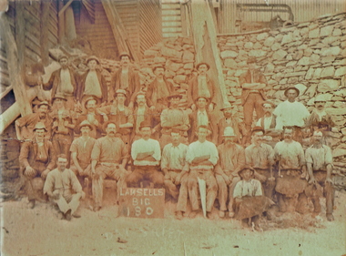
Photograph - LANSELL'S BIG 180 MINE WORKERS, c.1870's - 1880's
... lines. High stone retaining wall behind. Timber and iron... posed in three lines. High stone retaining wall behind. Timber ...Sepia photograph. Twenty nine mine workers posed in three lines. High stone retaining wall behind. Timber and iron buildings behind. Some men holding tools - blacksmiths with leather aprons holding hammers. One man holding a shovel, one man holding a saw. Inscriptions: on board in front of men 'Lansell's Big 180'person, group, mining -
 Nillumbik Shire Council
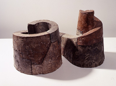
Sculpture: Mark STONER (b.1951 UK, arrived 1957 AUS), Untitled Spiral, 1991
... in the notion that ancient man-made structures such as stone walls... structures such as stone walls, which are intrinsic to many ...A small scale concrete work that can be imagined as an ancient monolithic fortress or religious edifice. It suggests ideas like perpetuity, worship, preservation and history. Untitled Spiral is made up of three spirals, the first is constructed as a closed form, the second is open and the third is the space created within the second. The sense of enclosure is powerful but this is offset by the ledge which traces the top edge of the spiral shapes. This pathway leads from a precarious position to the highest point of sanctuary, or to what Stoner refers to as Nirvana. The structure is built of masonry-like units which "suggest a material presence and earthiness". Stoner is absorbed by how we define landscape and what is meant by natural. He is interested in the notion that ancient man-made structures such as stone walls, which are intrinsic to many landscapes, can now be accepted as being natural, organic forms. -
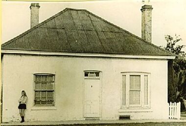
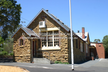
 Eltham District Historical Society Inc
Photograph, Fay Bridge, Eltham Primary School No. 209, Dalton Street, Eltham, 12 August 2006
... of stone walls with wooden shingles on the roof. That building... of stone walls with wooden shingles on the roof. That building ...ELTHAM PRIMARY SCHOOL CELEBRATIONS (EDHS Newsletter No. 170 September 2006) On 12 August the school celebrated its 150th anniversary with a most successful open day. Many former students, teachers and parents attended, together with local members of parliament and councillors. A congratulatory message from Premier Steve Bracks and Education Minister Lynne Kosky was read to the large crowd assembled to listen to the various speakers. Our members Jock Read and Geof Braithwaite were there as two of the longest surviving former students. Jock joined the youngest present day student in cutting the large birthday cake. Displays included historical information on Eltham and the school arranged by our Society and photos of school groups arranged into decades. The celebrations included the launch of a book to commemorate the event and titled "We Did Open a School in Little Eltham". The title is taken from a line in a letter from first head teacher David Clark who opened his first private school in a bark hut. This excellent publication of some 262 pages far exceeds the standard of most school commemorative histories, both in content and presentation. The three joint writers are all parents of students at the school. Ian Anderson, Barry Carozzi and Tarja Fellowes have spent many months researching and writing and are congratulated on the outcome. In the book they acknowledge the contribution of our President Harry Gilham and of Peter Cuffley, great grandson of Eltham pioneer Thomas Sweeney, Many of the photographs were provided by our Society. The stone building is the earliest building remaining on site today. It was built in 1875 and was the second school building replacing the original 1856 building of stone walls with wooden shingles on the roof. That building needed to be replaced after the stone walls collapsed outwards. In August 1912 the school issued a requisition for remodelling of the school concerned with replacement of the existing windows with larger and wider windows to allow additional light into the school rooms and the erection of a wooden partition in the centre of the room. An extension to the building at rear and skylights in the roof were added in 1921. Only two low wooden stairs were originally provided to enter the porch. These were rebuilt by 1928. A steel mud grate was introduced 1930s/1940s and an infant shelter shed circa 1945.fay bridge collection, eltham, 150th anniversary, 2006-08-12, eltham primary school, eltham state school no. 209 -
 Bendigo Military Museum
Photograph - New Printing Building Construction, Lithographic Squadron - Army Survey Regiment, Fortuna, Bendigo, c1989
... Regiment’s Collection. .1) to .2) - Photo, colour, 1989. Old stone... Regiment’s Collection. .1) to .2) - Photo, colour, 1989. Old stone ...This is a set of 12 photographs of contractors constructing Lithographic Squadron’s new Printing Building at Fortuna, Bendigo circa 1989. The building was purpose built to house a new computer-controlled Heidelberg Speedmaster five colour lithographic offset Printing Press. The print room was named Wayzgoose Hall after a medieval printing house festival. Wayzgoose Hall and the Speedmaster Press printing capability was commissioned by the Commander of the 3rd Military District BRIG P. Davies AM, ADC on Wednesday 27th June 1990. This occasion is covered in more detail in page 145 of Valerie Lovejoy’s book 'Mapmakers of Fortuna – A history of the Army Survey Regiment’ ISBN: 0-646-42120-4. See items 6131.18P and 6444.16P for photos of earlier phases of the construction process.This is a set of 12 photograph of the construction of Lithographic Squadron’s new Printing Building, Army Survey Regiment at Fortuna, Bendigo, c1989. Colour photographs are on 35mm negative film and scanned at 96 dpi. They are part of the Army Survey Regiment’s Collection. .1) to .2) - Photo, colour, 1989. Old stone retaining wall .3) to .12) - Photo, colour, 1989. Construction of new printing building.No personnel are identified. royal australian survey corps, rasvy, army survey regiment, army svy regt, fortuna, asr, litho sqn, printing -
 Melbourne Legacy
Photograph, Tyne Cot Cemetery, Passchedale. Photo L. Duhameeuw, Ypres, 1930
... . Stone wall at back has soldiers names engraved on same. Those.... Stone wall at back has soldiers names engraved on same. Those ...A photo of the Tyne Cot Cemetery in Passchendale dated September 24, 1930. It appears to be a professional photograph purchased as a souvenir. See also 01024 Menin Gate, Ypres, as it is by the same manufacturer. The Tyne Cot Commonwealth War Graves Cemetery and Memorial to the Missing is a Commonwealth War Graves Commission (CWGC) burial ground for the dead of the First World War in the Ypres Salient on the Western Front (source Wikipedia). The hand written inscription on the back of the photo says: "This memorial in Cemetery was built over a German dugout. 12,000 men are buried here. Stone wall at back has soldiers names engraved on same. Those unknown - words in stone 'Australian Soldier of the Great War Known unto God.' Australians captured Passchendale from the Germans Oct 4th 1917. Beautiful cemetery, all well kept, gardens, lawns, flowers. Ypres, Belgium Sept 24/30" The source of these photos is not known but they were stored together in the archives. The founders of Legacy were returned servicemen from the first world war and may have returned to France in the 1930s. Manufactured by L. Duhameeuw, Ypres.The professional photos from France imply that Legatees were making pilgrimages to the battlefields of France in the 1930s in memory of their comrades.Black and white photo of Tyne Cot Cemetery, Passchendale, France.Indistinct round stamp on the back and a handwritten message.world war one, souvenir, cemetery, memorial -
 Tatura Irrigation & Wartime Camps Museum
Painting - Painting - Water Colour, Franz Korbler, Darfeingang bei Damghan Iran, 1944 Loveday SA
... Water colour of brick wall, with stone entrance. Lady... colour of brick wall, with stone entrance. Lady standing ...Painting by Franz Korbler. Architect/artist, born Vienna Austria, arrested Teheran Persia September 12941. Interned Loveday Camp SA and Tatura Camp Victoria 1945-1947.Water colour of brick wall, with stone entrance. Lady standing in doorway, pot to right of her. Man standing centre of picture just in front of the entrance. Blue sky at top of picture.franz korbler -
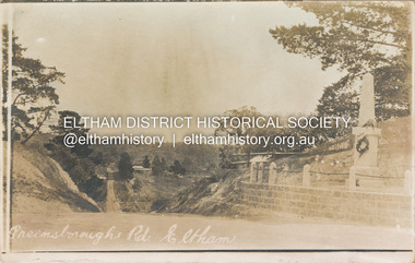 Eltham District Historical Society Inc
Postcard - Photograph postcard, Greensborough Road, Eltham, c.1925
... provision was made of a stone retaining wall topped with a chain... provision was made of a stone retaining wall topped with a chain ...Rare postcard showing view looking down Bridge Street with the Eltham Obelisk in situ in its original location. The Obelisk War Memorial was unveiled 3 August 1919. Subsequent to the unveiling provision was made of a stone retaining wall topped with a chain link and granite stone boundary. Along with the use of the name Obelisk Corner, the Bridge Street bridge was also known as Obelisk Bridge. The Obelisk was relocated to the fornt garden of the Eltham RSL sub-branch in the mid 1950s as a result of road widening and corner improvements. The Bridge Street Bridge was replaced with a new concrete bridge in 1956-1957.Digital file only Postcards scanned from the collection of Michael Aitken on loan to EDHS, 2 Sep. 2022michael aitken collection, eltham, postcards, bridge street, bridge street bridge, obelisk, obelisk corner, eltham cenotaph, eltham obelisk, war memorial, main road -
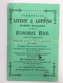 Warrnambool and District Historical Society Inc.
Document, Business Advertising Livery & Letting, 1882
... , was made up of different kinds of jumps including a stone wall..., was made up of different kinds of jumps including a stone wall ...The Warrnambool Amateur Turf Club was first formed in September 1859, but didn't become a properly constituted club until April 1873, when a meeting was held at the Commercial Hotel, now the Whaler's Inn, and a committee was elected.Part of the present racecourse of 100 acres was set aside as a racing and recreation reserve in August 1855. It is one of the finest racecourses in Australia, ringed by the gentle slopes of a huge basin.The first race meeting was held on the course in August 1858. The Warrnambool Racing Club has managed racing at Warrnambool since it was formed on 5 April 1873.Apart from a number of smaller meetings held throughout the year, the feature of racing in the district is the Grand Annual Steeplechase. The first steeplechase over the now famous cross-country course was run on 13th June 1872 then known as the Grand Annual Steeplechase. The paddocks now know as Brierly and Granters were first used on that date. The course, over four miles, was made up of different kinds of jumps including a stone wall, a log fence, a ditch and parapet, a paling fence and numerous post and rails.This card has Warrnambool Racing Club acceptances on one side for the Winter steeplechase meeting for the June meeting in 1882. Stansmore Bros. operated livery stables near the Commercial Hotel in Liebig Street around this time having commenced their business in Camperdown.They later moved to Kepler Street. The Stansmore family had a long association with the racing and agricultural industry in the Camperdown and Heytesbury areas. This little card has links to one of Warrnambool's premier sporting events and a local business which has strong family connections in the district.Small green card with black text on front and back. Edged with small lined border. The back has a racing schedule.Commercial Livery & letting Stables Warrnambool.Stanmore Bros. Warrnambool Racing Club, J.A Archibald Secretary WRCwarrnambool,, commercial livery & letting stables, stansmore brothers stables, warrnambool racing club 1882 -
 Bendigo Military Museum
Photograph - PHOTOGRAPH, FRAMED WW1, Wayne Eels, C.2008/09
... of six men. Background - wall of stone and timber building... of six men. Background - wall of stone and timber building. Frame ...The Grinton Collection. Photo taken at a 38th Bn reunion at Bert Grintons Farm Myers Flat near Bendigo. Left to Right in photo; Jack Grinton, Fred Lehmann "MM", Dick Verso, Bert Grinton "DCM" , ..........Poppin. "Jack Grinton No. 1038," 38th Battalion - Refer Cat No. 1280 for his service history. "Bert Grinton DCM, No. 5024" - Refer Cat No. 1320 for his service history. Photograph - framed. Photograph - black and white photograph on paper depicts an informal group, full length portrait of six men. Background - wall of stone and timber building. Frame - timber, light varnish finish, Perspex front, cardboard backing."Single photos Group 2 (end of show): 38th Battalion Reunion".framed accessories, camera on the somme, ww1, 38th bn, grinton -
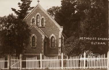 Eltham District Historical Society Inc
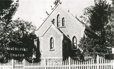
Photograph, Eltham Methodist Church, 1909, 1909
... constructed with stone from the walls of the first Eltham State... constructed with stone from the walls of the first Eltham State ...Situated at 810 Main Road on the corner of John Street. The Church was surrounded by a picket fence and tall pine trees. The Church was built by George Stebbings in the 1850s and is an example of fine craftmanship. Formerly Wesleyan, Methodist then Uniting church; the foundations of the church building were constructed with stone from the walls of the first Eltham State Primary School (No. 209) building which collapsed in 1874 and were purchased by Robert David Taylor. REVISED STATEMENT OF SIGNIFICANCE, CONTEXT, 2010 via Victorian Heritage Database What is significant? The 1880 bichromatic brick church and the surrounding site to the title boundaries. How is it significant? The church is architecturally, historically, socially and spiritually significant to the Shire of Nillumbik. Why is it significant? The church is architecturally significant as a finely detailed example of a brick 19th century rural community church, one of only four in the Shire (Criteria E & B). The church is historically significant as an important link with the time when Eltham was a small, insular country settlement. Also for the historical evolution visible in the complex, with the modest 1880s church and larger red brick rear hall from the early 20th century as a reflection of population growth in the area (Criterion A). The church is historically, spiritually and socially significant because it has played, and continues to play, an important part in the spiritual and social life of the community (Criterion G).Sepia postcard of Eltham Methodist Church, 1909eltham, methodist church, church, state school no. 209, eltham state school, robert david taylor, eltham uniting church, uniting church, wesleyan church -
 Hume City Civic Collection
Photograph, 1993
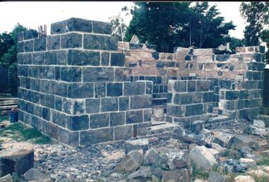
... has commenced on the front and back walls. Some stones... has commenced on the front and back walls. Some stones ...The Aitkens Gap Gaol was removed from its original site at Gap Village on the Calder Highway and relocated in front of the Sunbury Police Station in 1993.A coloured photograph of the resiting and rebuilding of the Aitken Gap Gaol outside the Police Station in Sunbury. The two end walls have been constructed as far as the windows and work has commenced on the front and back walls. Some stones are scattered around the site.peter free, aitkens gap gaol, sunbury police station, police historical association, george evans collection -
 Buninyong & District Historical Society
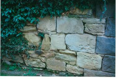
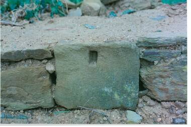
Photograph - Original Photograph, C J Brooks, Section of sandstone wall, 405 Learmonth St. Buninyong, July 1995
... Stone of which wall is constructed is believed to have been..., Buninyong Town Hall Learmonth Street Buninyong goldfields Stone ...Stone of which wall is constructed is believed to have been used in the construction of Jamieson's Buninyong Inn, built for Margaret Jamieson starting about 1853. She owned the earlier Buninyong Inn which impinged on they surveyed Learmonth St. and was demolished. Margaret died in 1854 before the building was completed by her son, who built the third Buninyong Inn on the corner of Learmonth and Warrenheip. The two story hotel was tenented for a while, then bought by Dr. Sparling who demolished it.Colour photo, Section of sandstone wall, 405 Learmonth St. Buninyong.buninyong, jamieson, sparling, buninyong inn, wall, sandstone -
 Buninyong & District Historical Society
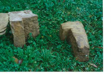
Photograph - Original Photograph, C J Brooks, Sandstone blocks awaiting incorporation into reconstruction of wall, 405 Learmonth St. Buninyong, July 1995
... Stone of which wall is constructed is believed to have been..., Buninyong Town Hall Learmonth Street Buninyong goldfields Stone ...Stone of which wall is constructed is believed to have been used in the construction of Jamieson's Buninyong Inn, built for Margaret Jamieson starting about 1853. She owned the earlier Buninyong Inn which impinged on they surveyed Learmonth St. and was demolished. Margaret died in 1854 before the building was completed by her son, who built the third Buninyong Inn on the corner of Learmonth and Warrenheip. The two story hotel was tenented for a while, then bought by Dr. Sparling who demolished it.Colour photo, Sandstone blocks awaiting incorporation into reconstruction of wall, 405 Learmonth St. Buninyongbuninyong, jamieson, sparling, buninyong inn, wall, sandstone -
 Buninyong & District Historical Society
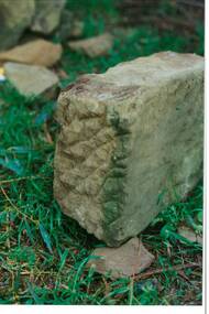
Photograph - Original Photograph, C J Brooks, Individual Sandstone block, awaiting incorporation into reconstruction of wall, for Mr. H & Mrs. D Westbrooke, 1995, at 405 Learmonth St. Buninyong, July 1995
... Stone of which wall is constructed is believed to have been..., Buninyong Town Hall Learmonth Street Buninyong goldfields Stone ...Stone of which wall is constructed is believed to have been used in the construction of Jamieson's Buninyong Inn, built for Margaret Jamieson starting about 1853. She owned the earlier Buninyong Inn which impinged on they surveyed Learmonth St. and was demolished. Margaret died in 1854 before the building was completed by her son, who built the third Buninyong Inn on the corner of Learmonth and Warrenheip. The two story hotel was tenented for a while, then bought by Dr. Sparling who demolished it.Colour photo, Individual Sandstone block, awaiting incorporation into reconstruction of wall, for Mr. H & Mrs. D Westbrooke, 1995, at 405 Learmonth St. Buninyongbuninyong, jamieson, sparling, buninyong inn, wall, sandstone -
 Buninyong & District Historical Society
Photograph - Original Photograph, C J Brooks, Individual Sandstone block showing hole to support wooden strut, in reconstruction of wall, at 405 Learmonth St. Buninyong, July 1995
... Stone of which wall is constructed is believed to have been..., Buninyong Town Hall Learmonth Street Buninyong goldfields Stone ...Stone of which wall is constructed is believed to have been used in the construction of Jamieson's Buninyong Inn, built for Margaret Jamieson starting about 1853. She owned the earlier Buninyong Inn which impinged on they surveyed Learmonth St. and was demolished. Margaret died in 1854 before the building was completed by her son, who built the third Buninyong Inn on the corner of Learmonth and Warrenheip. The two story hotel was tenented for a while, then bought by Dr. Sparling who demolished it.Colour photo, bottom section of wall, showing individual Sandstone block with hole to support wooden strut, in reconstruction of wall, at 405 Learmonth St. Buninyongbuninyong, jamieson, sparling, buninyong inn, wall, sandstone -
 Buninyong & District Historical Society
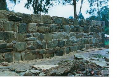
Photograph - Original Photograph, C J Brooks, Sandstone wall after rebuilding at 405 Learmonth St. Buninyong, July 1995
... Stone of which wall is constructed is believed to have been..., Buninyong Town Hall Learmonth Street Buninyong goldfields Stone ...Stone of which wall is constructed is believed to have been used in the construction of Jamieson's Buninyong Inn, built for Margaret Jamieson starting about 1853. She owned the earlier Buninyong Inn which impinged on they surveyed Learmonth St. and was demolished. Margaret died in 1854 before the building was completed by her son, who built the third Buninyong Inn on the corner of Learmonth and Warrenheip. The two story hotel was tenented for a while, then bought by Dr. Sparling who demolished it.Colour photo, Sandstone wall after rebuilding at 405 Learmonth St. Buninyongbuninyong, jamieson, sparling, buninyong inn, wall, sandstone -
 Tatura Irrigation & Wartime Camps Museum
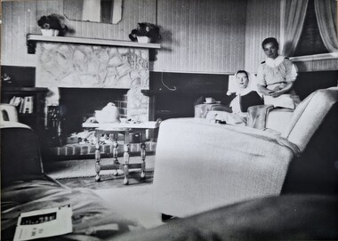
Photograph, Sisters sitting room, Original 1943, copy 1989
... stone fireplace. Centre left wall with low white bowls... duty nurses sitting room, local stone fireplace. Centre left ...WW2 internment camp 1 hospital nursing staffTwo A.A.N.S. sisters. Off duty nurses sitting room, local stone fireplace. Centre left wall with low white bowls of flowers. Books in book case. L/coffee table (round) with tray, teapot, etc. centre. Large armchair, right foreground.nursing staff, internment camp 1, a.a.n.s. -
 Bendigo Historical Society Inc.
Map - BENDIGO HISTORICAL SOCIETY COLLECTION: EAGLEHAWK MINE MAP
... (1) stone walls G. North Lightning Hill Mine, engine... Moon Mines Dams (1) stone walls G. North Lightning Hill Mine ...Base map Australian map grid of Eaglehawk area. Map has letter attached from the Department of Conservation, Forests and Lands, 22 March, 1990, addressed to Felicity Kingerlie, BHS, requesting information regarding the historic mining sites marked on the map. Sites marked are: A. Golden Age Mine, engine mountings present B. Johnson's No. 2 Mine, engine mountings, old boiler foundations C. Johnson's No. 1 Mine, mullock retaining wall made from sandstone, engine mountings, remains of old building demolished? D. Toma's Eucalyptus Factory, old boiler still there, boiler shed, chimney (remnants of) outlet drain, distilling vats, dam, remnant of winch. E. New Argus Mine,mullock heap F. New Moon Mines Dams (1) stone walls G. North Lightning Hill Mine, engine mountings, quartz retainer wall, Pascoe and Simmons open cuts and other open cuts here too H. New Prince of Wales Mine and Poppet Head I. Quarry site for stone, excavation (for miners cottages in Clarke Street) J. Lancashire open cut mine K. Virginia Hill (cynaide vats etc) L. South Prince of Wales mine, now capped and fenced M (possibly ) Catherine United Mine, engine mountings, battery mountings?bendigo, mining, eaglehawk mines -
 Wodonga & District Historical Society Inc
Photograph - Stonleigh, Wodonga
... with the stone walls being 18 inches (46cm) thick. It was a four-room... with the stone walls being 18 inches (46cm) thick. It was a four-room ...Stonleigh is one of Wodonga’s earliest buildings and stands on land granted to Daniel Rhodes in 1854, in one of the first land sales conducted in Wodonga. The building commenced soon after with the stone walls being 18 inches (46cm) thick. It was a four-room granite rubble stone building with central door and a window on either side, with a separate kitchen, as was typical of the worker's cottage of the day. The original roof would have been shingles but it was replaced with corrugated iron. It passed through several owners including Paul Huon in 1858. Peter Tenner, a farmer and vigneron took over in 1866 when it was described as “built of stone and having a cellar and a detached kitchen plus outside toilet, and a shed or two.” In the late 1880’s it was owned by William Smith who had come to Wodonga as a missionary for the Presbyterian Church and who, together with John Whan, storekeeper, was instrumental in building the Presbyterian Church nearby. Between 1890 and 1910 further buildings were added, consisting of double brick walls, two bedrooms, kitchen, laundry with brick and copper, bathroom and side verandah. William Smith established Wodonga Cordage Works in the Stonleigh buildings. The front room of the house was the display room for the business which manufactured and sold fishing lines, various types of cordage and water bags, the latter being of hand-sewn canvas. After 1954 Stonleigh became a bottle depot and bottle museum under ownership of Ramon Porta. At one stage he had over 50,000 bottles on display. In 1991 it was purchased by Mark Fraser, a cabinet maker, who made extensive renovations at the rear of the premises and internally, but left the façade untouched. Over recent times, Stonleigh was the home of several business including a florist, a patchwork maker and a café. Stonleigh was sold in 2021 and is now a private residence.These images capture one of Wodonga's oldest buildings.A series of photos, both colour and black and white, showing the building "Stonleigh' at different periodsstonleigh wodonga, old buildings wodonga, wodonga businesses, wodonga pioneers -
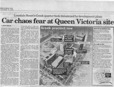 Queen Victoria Women's Centre
Newspaper excerpt, The Sunday Age, Car Chaos fear at Queen Victoria Site: Lonsdale Street's Greek quarter feels threatened by development plans, 29 October 2000
... of blue-stone and cast-iron wall which was to be demolished... of blue-stone and cast-iron wall which was to be demolished ...Newspaper excerpt from The Sunday Age. Page 5 and a smaller introduction probably from the front page. Smaller excerpt colour photo of blue-stone and cast-iron wall which was to be demolished. Larger excerpt, a black and white aerial view of QVWC and the block where it is situated. building construction, building permits, historic building -
 Eltham District Historical Society Inc
Photograph - Digital Photograph, Alan King, Eltham Primary School No. 209, Dalton Street, Eltham, 28 December 2007
... replacing the original 1856 building of stone walls with wooden... replacing the original 1856 building of stone walls with wooden ...This building is the earliest building remaining on site today. It was built in 1875 and was the second school building replacing the original 1856 building of stone walls with wooden shingles on the roof. That building needed to be replaced after the stone walls collapsed outwards. In August 1912 the school issued a requisition for remodelling of the school concerned with replacement of the existing windows with larger and wider windows to allow additional light into the school rooms and the erection of a wooden partition in the centre of the room. An extension to the building at rear and skylights in the roof were added in 1921. Only two low wooden stairs were originally provided to enter the porch. These were rebuilt by 1928. A steel mud grate was introduced 1930s/1940s and an infant shelter shed circa 1945. Covered under Heritage Overlay, Nillumbik Planning Scheme. Published: Nillumbik Now and Then / Marguerite Marshall 2008; photographs Alan King with Marguerite Marshall.; p49 Eltham Primary School at Dalton Street, bustling with hundreds of students, has changed dramatically since it began in July 1855.1 A reminder of its early days is the building in local sandstone with a slate roof. First head teacher was David G Clark who was officially in charge from June 1856 until 1889.2 This school was not the settlement’s first. That was the Church of England Little Eltham School, west of Diamond Creek in 1853 and closed in 1872. In 1855 David Clark and his sister Catherine, opened what was to become the present school, with eight students. The school operated elsewhere in a temporary slab building, also used for worship by the Wesleyans,3 which allowed the wind and rain easy access. As well as having to endure such Spartan conditions, the students paid one penny a week for the privilege. But in June 1856 the patrons objected to the conditions, and they and the Clarks wrote to the National Schools Board, asking for a suitable school. They asked for a grant to buy land for a school, and to appoint the Clarks. As a result, inspector Mr A B Orlebar visited the school. He found 33 children aged from four to 13 and noted, among other things: ‘There is no attempt at classification, and this is owing chiefly to the want of books, every child bringing with it any spelling or reading book he or she may find at home,4 and partly to the master and mistress having little idea of anything but individual instruction.’ Of Mr Clark, Mr Orlebar said: ‘I cannot pass him as coming up to the full standard of a probationer. He promises however to pursue a course….if the commissioners take him into their service.’ Of Catherine: ‘She makes a promise similar to that of her brother. Pupils were orderly and the school seemed well conducted. I cannot therefore hesitate to recommend them both personally as probationers.’ Later at a public meeting, Mr Orlebar pledged the commissioners would give £150 for a school, if this was matched by local residents. The meeting decided the commissioners would acquire two acres (0.8ha) for the school site. The building, constructed with local sandstone, was completed in December 1857, measuring 40 feet x 16 feet (12mx5m) and 10 feet (3m) high. It was divided into two rooms – one for the school and the other for teacher accommodation. So the Eltham school was born, in an area regarded as ‘one of the poorest in the colony’. Excerpts from inspectors’ reports in the following years, show that in some ways school has not changed that much since then: ‘Discipline only moderate. Too much chattering!’ (1873); ‘Several slates were cleaned with saliva applied by the hand! Damp rags would be much nicer.’(1891).5 In 1863 the Board of Education took over the school giving it its current name and number, Eltham Primary School No 209. Overcrowding has dogged the school over much of its history. In 1875 overcrowding spilled part of the school into the local courthouse. But that year the sandstone building, which is still standing, was built for 100 children, costing £553 and replacing the National School building. Now, this section, even following renovations, still bears part of its original graciousness, with lofty timber ceilings, tall vertical windows and original floors.This collection of almost 130 photos about places and people within the Shire of Nillumbik, an urban and rural municipality in Melbourne's north, contributes to an understanding of the history of the Shire. Published in 2008 immediately prior to the Black Saturday bushfires of February 7, 2009, it documents sites that were impacted, and in some cases destroyed by the fires. It includes photographs taken especially for the publication, creating a unique time capsule representing the Shire in the early 21st century. It remains the most recent comprehenesive publication devoted to the Shire's history connecting local residents to the past. nillumbik now and then (marshall-king) collection, dalton street, eltham primary school, state school no. 209 -
 Stawell Historical Society Inc
Photograph, Fluming Water Supply in the Grampians 1991 -- 9 Photos -- Coloured
... . Halls Gap Old metal flume and man made stone supporting wall. g.... Halls Gap Old metal flume and man made stone supporting wall. g ...Coloured photos of Fluming Water Supply in the Grampians. a. Grampians Exit of tunnel through Mt William Range built 1874. b. Halls Gap Fyan's Creek with buried pipe from new diversion Weir Nov 24/91 (Fume Main). c. Halls Gap New Diversion Weir (Keith Phillips) Nov 24/1991. d. Halls Gap Old pipe to open flume adapter Nov 24/1991. e. Halls Gap Old metal open flume Nov24/91. f. Halls Gap Old metal flume and man made stone supporting wall. g. Halls Gap Overhanging rocks above old fume line Nov 24/1991. h. Halls Gap Old pipe to open flume adapter Bill Holmes Nov 24/91. i. Grampians Old hut for controlling flow valves etc. at Stawell side of Mount William Range after tunnel exit. Nine colour photographs of various views around a tunnel through a hill site.grampians water supply flume -
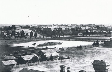 Bendigo Historical Society Inc.
Photograph - LANDSCAPE VIEW OF BENDIGO
... or dam with small island centre, stone brick wall with lookout... building behind. Lake or dam with small island centre, stone brick ...Black and white photograph. In foreground, roof and chimneys. Row of 3 small weatherboard houses with verandah, picket fences. 1 small and 1 larger building behind. Lake or dam with small island centre, stone brick wall with lookout tower at corner ( Bendigo gaol ) at right centre distanc,e large building. Benevolent Asylum. Many other buildings in distance. James Lerk 11.2.2000 ' view from the Corporate High School, Benevolent Asylum in centre' Unknown BHS member 5.11.1999 ' lower dam ( site of present tennis courts, Park Road, pumped out C 1926' Written on back of photo 'Bendigo Victoria 1860's, Sandhurst North view 100 miles north from Melbourne. C. Nettleton, Victorian Views'C. Nettleton ?place, landscape view, bendigo -
 Eltham District Historical Society Inc
Photograph, Tom Prior, Methodist Church, Eltham
... constructed with stone from the walls of the first Eltham State... constructed with stone from the walls of the first Eltham State ...Situated at 810 Main Road on the corner of John Street. The Church was surrounded by a picket fence and tall pine trees. The Church was built by George Stebbings in the 1850s and is an example of fine craftmanship. Formerly Wesleyan, Methodist then Uniting church; the foundations of the church building were constructed with stone from the walls of the first Eltham State Primary School (No. 209) building which collapsed in 1874 and were purchased by Robert David Taylor. The Reynolds/Prior Photograph Collection, Presented to the Eltham District Historical Society, 14 June 2006 by Ross McDonald. A second copy was also presented to the Andrew Ross Museum, Kangaroo Ground The Reynolds family were early settlers in Research. Reynolds Road is named after this family. RERVISED STATEMENT OF SIGNIFICANCE, CONTEXT, 2010 What is significant? The 1880 bichromatic brick church and the surrounding site to the title boundaries. The church is architecturally, historically, socially and spiritually significant to the Shire of Nillumbik. Why is it significant? The church is architecturally significant as a finely detailed example of a brick 19th century rural community church, one of only four in the Shire (Criteria E & B). The church is historically significant as an important link with the time when Eltham was a small, insular country settlement. Also for the historical evolution visible in the complex, with the modest 1880s church and larger red brick rear hall from the early 20th century as a reflection of population growth in the area (Criterion A). The church is historically, spiritually and socially significant because it has played, and continues to play, an important part in the spiritual and social life of the community (Criterion G). - Victorian Heritage Database The Reynolds family were early settlers in Research. The Reynolds/ Prior collection of photographs were taken by Tom Prior, the maternal uncle of Ivy Reynolds, around 1900 and the 60 photos in the album give a fine overview of many of the landmarks of Research and Eltham over 100 years ago. lvy lived in the family home for many years at 106 Thompson Cres Research. Ivy's father, Ernst Richard Reynolds and grandfather, Richard Reynolds, lived at the same address. Ivy's father Richard worked for Mr. Trail on his property in Research. Reynolds Road is named after the family. Mr Tom Prior (wife Eva) worked at the Melbourne zoo. He was very innovative and made his own camera, using the black cloth hood to exclude the light. The photographs are a reminder of the rural nature of Research and Eltham and its rich heritage. Black and white photograph mounted in an album, the Reynolds/Prior Photograph Collection, this being one of 53 reproduced black and white images of early Eltham."Methodist Church" reynolds prior collection, eltham, methodist church -
 Warrnambool and District Historical Society Inc.
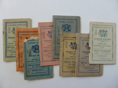
Document - Warrnambool. Woodford. Winslow. Purnim Race Books, Modern Print, W’Bool, Victoria, 1920's and 1930's
... , was made up of different kinds of jumps including a stone wall... of different kinds of jumps including a stone wall, a log fence ...The Warrnambool Amateur Turf Club was first formed in September 1859, but didn't become a properly constituted club until April 1873, when a meeting was held at the Commercial Hotel, now the Whaler's Inn, and a committee was elected.Part of the present racecourse of 100 acres was set aside as a racing and recreation reserve in August 1855. It is one of the finest racecourses in Australia, ringed by the gentle slopes of a huge basin.The first race meeting was held on the course in August 1858. The Warrnambool Racing Club has managed racing at Warrnambool since it was formed on 5 April 1873.Apart from a number of smaller meetings held throughout the year, the feature of racing in the district is the Grand Annual Steeplechase. The first steeplechase over the now famous cross-country course was run on 13th June 1872 then known as the Grand Annual Steeplechase. The paddocks now know as Brierly and Granters were first used on that date. The course, over four miles, was made up of different kinds of jumps including a stone wall, a log fence, a ditch and parapet, a paling fence and numerous post and rails. The name Grand Annual was first used for this steeplechase in May 1895. It is the longest horse race in Australia, and the thirty three fences of the course, the most of any steeplechase in the world is raced over 5,500 metres. The three day May racing carnival is the major racing event on the horseracing and social calendar. Many of these race booklets relate to those May meetings. The Warrnambool Racecourse has been the home of district racing clubs such as Woodford, Purnim and Koroit over the latter part of the 20th century. The Woodford Racing club holds their annual meeting after Christmas each year. The Winslow races were held from approximately mid-19th century to around 1946. It began as a small picnic race club in Tobin’s paddock to a splendid race course on the property, “Green Hills” owned by Mr. John O’Keefe about one mile north of the Winslow township.. The annual meetings held on New Year’s Day drew crowds of seven to eight thousand people. All of these books contains family names which in some cases are still strongly linked to horse racing in the district.These booklets are a tangible link to a great sporting and social event in the Western District. A collection of programmes for race meetings. They relate to Warrnambool, Woodford, Purnim, Winslow and Victoria Racing Club meetings in the period 1922 to 1931. All are soft card covers with approximately 16 pages in each in white paper. They are numbered as follows: 001250.1 WRC Soft green cover with blue text 01/05/1923 001250.2 WRC Mauve cover with blue text 03/05/1923 001250.3 WRC fawn cover with red text 06/05/1924 001250.4 WRC Orange cover with blue text 08/05/1924 001250.5 WRC Soft green cover with light brown text 05/05/1925 001250.6 WRC Soft green cover with red text 07/05/1925 001250.7 WRC fawn cover with brown text 04/05/1926 001250.8 Woodford racing Club soft pink cover, Blue text 01/04/1922 001250.9 Woodford racing Club green cover, Blue text 07/04/1923 001250.9 Woodford racing Club grey cover, Blue text 05/04/1924 001250.10 Woodford racing Club grey cover, Blue text 05/04/1924 001250.11 Woodford Racing Club green cover, Blue text 22/11/1924 001250.12 Woodford Racing Club green cover, brown text 04/04/1925 001250.13 Woodford Racing Club orange cover, blue text 10/04/1926 001250.14 Woodford Racing Club pink cover, green text 10/04/1926 001250.15 Warrnambool Racing Club pink cover, blue text 18/11/1922 001250.16 Warrnambool Racing Club pink cover, red text 13/11/1926 001250.17 Warrnambool Racing Club cream cover, brown text 15/11/1924 001250.18 Warrnambool Racing Club cream cover, green text 18/01/1922 001250.19 Warrnambool Racing Club grey cover, blue text 15/01/1924 001250.20 Warrnambool Racing Club cream cover, blue text 13/01/1925 001250.21 Warrnambool Racing Club pink cover, blue text 15/01/1925 001250.22 Warrnambool Racing Club olive green cover, blue text 12/01/1926 001250.23 Warrnambool Racing Club blue cover, blue text 14/01/1926 001250.24 Warrnambool Racing Club soft green cover, blue text 13/01/1931 001250.24 Warrnambool Racing Club orange cover, black text 16/01/1930 001250.25 Warrnambool Racing Club orange cover, black text 16/01/1930 001250.26 Purnim Racing Club green cover, blue text 19/05/1924 001250.27 Winslow Racing Club pink cover,black text 21/04/1923 001250.28 Winslow Racing Club green cover,black text 06/12/1924 001250.29 Victoria Racing Club cream cover,green text 11/07//1923 001250.30 Victoria Racing Club cream cover, red text 14/07//1923 Most of the booklets have markings with place getters and jockeys marked in pencil. Warrnambool Racing club books have R U Forbes, C T Alexander A H Davies and William White as secretaries. Woodford club has Thomas Gleeson as secretary, Winslow 's secretary is W Latta and Purnim is P J Kelly. The local booklets are printed by The Modern Print Co Koroit St Warrnambool.warrnambool, warrnambool racing club, winslow racing club, woodford racing club, purnim racing club, victoria racing club -
 Eltham District Historical Society Inc
Negative - Photograph, Warrandyte Bridge over River Yarra, c.1910
... consist of dry stone walls, 6ft. thick at the base, and tapering... consist of dry stone walls, 6ft. thick at the base, and tapering ...View of the 1875 timber trestle bridge over the Yarra River reproduced from a newsprint image. Also known as Anderson's Creek (Road) Bridge A contract was accepted for William Elliot to erect a bridge over the Yarra River at Warrandyte on Anderson's Creek Road and other improvements for £1,331.6.2 - Gazette No. 143. Tuesday, November 13th 1860 - http://gazette.slv.vic.gov.au/view.cgi?year=1860&class=general&page_num=2161&state=V&classNum=G143&id=). The bridge was washed away by floods in 1863. It was replaced with a taller timber trestle structure in October 1875, designed and built by C.S. Wingrove, Shire Clerk, Engineer and Surveyor for Eltham Shire Council. A replacement for this bridge was commenced in 1955 to cope with increasing traffic and this structure was widened in 2018 to meet further traffic demands. Argus (Melbourne, Vic. : 1848 - 1957), Thursday 23 September 1875, page 7 ________________________________________ THE WARRANDYTE BRIDGE. The ceremony of formally opening the newly erected bridge over the Yarra at Ander-son's Creek was performed on Monday last, in the presence of the members of the Eltham and Bulleen shire councils whose territories it joins, and a goodly number of the residents of the district. The task was delegated to Mr. Cameron, M.L.A., who, after a few introductory remarks declared the bridge to be opened, and christened it the " Warrandyte Bridge." The party then adjourned to Grant's Hotel, where a cold collation had been prepared. The chair was taken by the president of the Eltham shire (Mr. John Bell) and the vice chair by Mr. Kent, a member of the Bulleen council. Mr Robert Williamson proposed "Success to the bridge," coupling with it the name of Mr. Cameron, to whose exertions was in the main to be attributed the erection of that structure which was an ornament to the district and would prove of great service to both sides of the river. Mr. Cameron, in responding, alluded to the great difficulties, mainly of a pecuniary nature, that had been encountered in carrying out the project, and which had only been got over by their united efforts and by the liberal spirit in which the late Commissioner of Roads had dealt with the case. The healths of the contractor and the engineer were also drunk. The bridge is a trussed timber one, resting on yellow box piles sunk into the solid rock, each pier being weighted with 50 tons of stone. The abutments consist of dry stone walls, 6ft. thick at the base, and tapering to 3ft. on the top, the face of the work having a batter of 1 to 1. The length of the bridge is 308ft., there being four openings in the centre of 66ft. each, and two at the ends of 20ft. each. The width in the clear is 9½ft., and the height from the bed of the river about 33ft. The approaches comprise 1,100 cubic yards of earthwork, and the formation of 48 chains of sideling, the whole cost of the work, which was carried out under the direction of the engineer to the Eltham Shire Council, being £1,413.This photo forms part of a collection of photographs gathered by the Shire of Eltham for their centenary project book,"Pioneers and Painters: 100 years of the Shire of Eltham" by Alan Marshall (1971). The collection of over 500 images is held in partnership between Eltham District Historical Society and Yarra Plenty Regional Library (Eltham Library) and is now formally known as the 'The Shire of Eltham Pioneers Photograph Collection.' It is significant in being the first community sourced collection representing the places and people of the Shire's first one hundred years.Digital image 4 x 5 inch B&W Neg B&W Print 12.5 x 9 cmsepp, shire of eltham pioneers photograph collection, warrandyte, bridge -
 Eltham District Historical Society Inc
Document, Prospectus: Kinloch Gardens, Eltham Victoria, 1998c
... from the outside world behind high stone retaining walls... from the outside world behind high stone retaining walls ...“Kinloch Gardens at Eltham, Victoria is planned as a comprehensively designed and cohesive residential environment.” “Only twelve innovatively designed houses ,will be situated within the established gardens and grounds of this historic Eltham estate. Building design and development will be under the control of the Kinloch Gardens design and construction team.” “Kinloch Gardens is situated on one of the highest points in Eltham and enjoys panoramic views in all directions.” “Kinloch Gardens lies hidden from the outside world behind high stone retaining walls, terraced embankments and extensive landscaping. The existing buildings, amongst the most significant of the Eltham / Montsalvat domestic building tradition are set in park like surrounds and enjoy panoramic views of the ranges to the north east and the city sky line to the west. New houses combined with sensitive landscaping will blend immediately into the established garden environment and will share the amenity and ambience of a very private and unique estate. The central theme of the landscape master plan is a garden reserve and a planted avenue terminating in a -small square.” “Houses vary in size from 120m2 (12.9 squares) to 210m2 (22.6 squares) (or larger) and include an extensive range of planning options. House types include: The Studio House The Tower House The Pergola House The Gallery House 'The Barn' is one of the existing buildings of Kinloch Gardens and is situated on the premium Lot 11.” Developer: Kinloch Pty Ltd. Project Managers: Creative Block Design Pty Ltd. Architects: Graeme Gunn and Ian Jelbart. Landscape Architect: Suzy Boyd. Builder: Vizarje Homes Pty Ltd. Surveyors and Engineers: Miller Merrigan.Digital file only; created from scan undertaken by EDHSarthur street, creative block design pty ltd., eltham, graeme gunn, houses, ian jelbart, kinloch gardens, kinloch pty ltd, miller merrigan, real estate, suzy boyd, vizarje homes pty ltd. -
 Eltham District Historical Society Inc
Document, Kinloch Gardens Property Album; Elders Real Estate sales material, 1998
... from the outside world behind high stone retaining walls... from the outside world behind high stone retaining walls ...“Kinloch Gardens at Eltham, Victoria is planned as a comprehensively designed and cohesive residential environment.” “Only twelve innovatively designed houses ,will be situated within the established gardens and grounds of this historic Eltham estate. Building design and development will be under the control of the Kinloch Gardens design and construction team.” “Kinloch Gardens is situated on one of the highest points in Eltham and enjoys panoramic views in all directions.” “Kinloch Gardens lies hidden from the outside world behind high stone retaining walls, terraced embankments and extensive landscaping. The existing buildings, amongst the most significant of the Eltham / Montsalvat domestic building tradition are set in park like surrounds and enjoy panoramic views of the ranges to the north east and the city sky line to the west. New houses combined with sensitive landscaping will blend immediately into the established garden environment and will share the amenity and ambience of a very private and unique estate. The central theme of the landscape master plan is a garden reserve and a planted avenue terminating in a -small square.” “Houses vary in size from 120m2 (12.9 squares) to 210m2 (22.6 squares) (or larger) and include an extensive range of planning options. House types include: The Studio House The Tower House The Pergola House The Gallery House 'The Barn' is one of the existing buildings of Kinloch Gardens and is situated on the premium Lot 11.” Developer: Kinloch Pty Ltd. Project Managers: Creative Block Design Pty Ltd. Architects: Graeme Gunn and Ian Jelbart. Landscape Architect: Suzy Boyd. Builder: Vizarje Homes Pty Ltd. Surveyors and Engineers: Miller Merrigan.Digital file only; created from scan undertaken by EDHSarthur street, elders real estate, eltham, kinloch gardens, real estate agent, the barn